Correlation of Ground Deformation Induced by the 6 February 2023 M7.8 and M7.5 Earthquakes in Turkey Inferred by Sentinel-2 and Critical Exposure in Gaziantep and Kahramanmaraş Cities
Abstract
1. Introduction
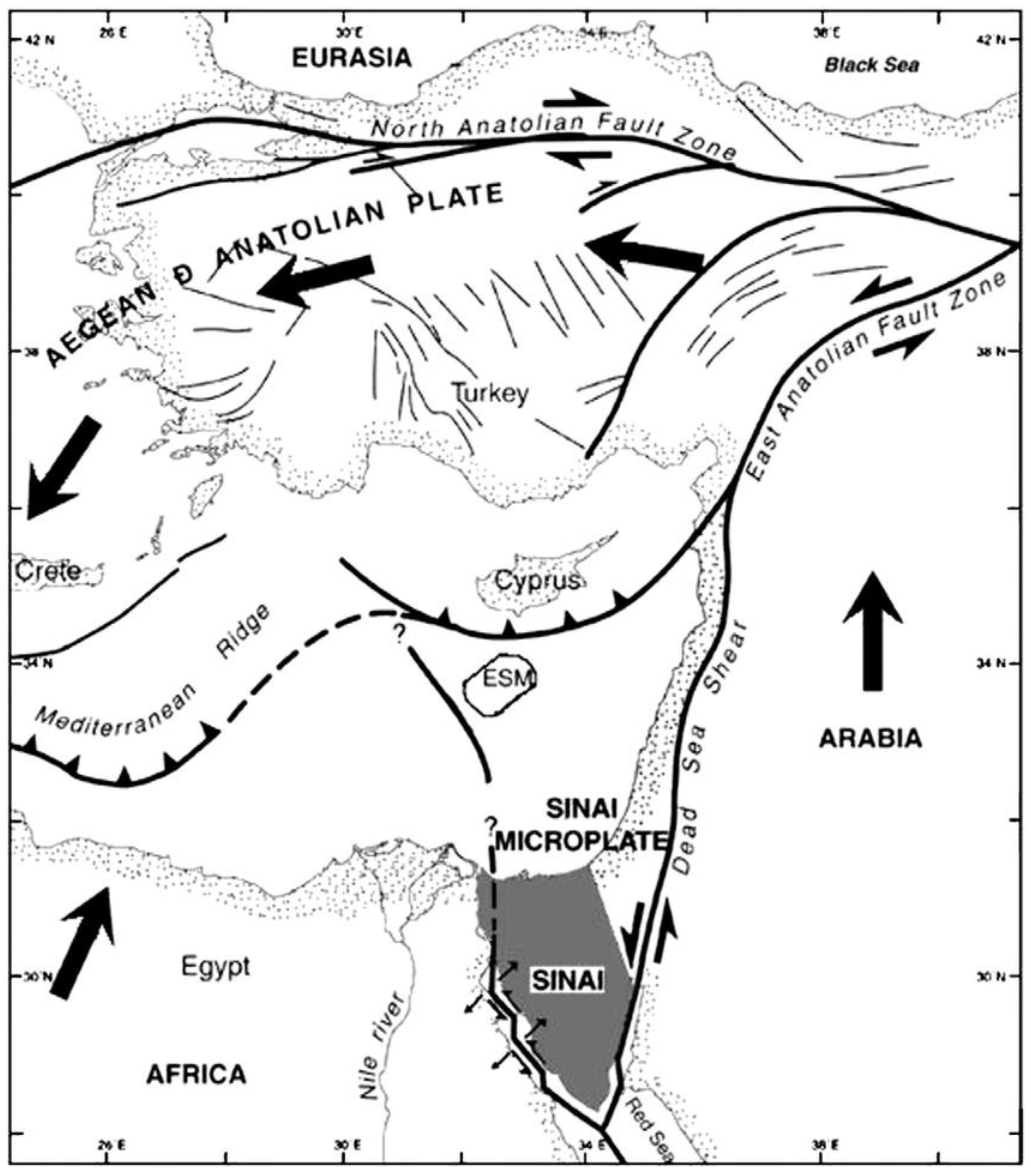
2. Tectonic Setting of the Broader Area
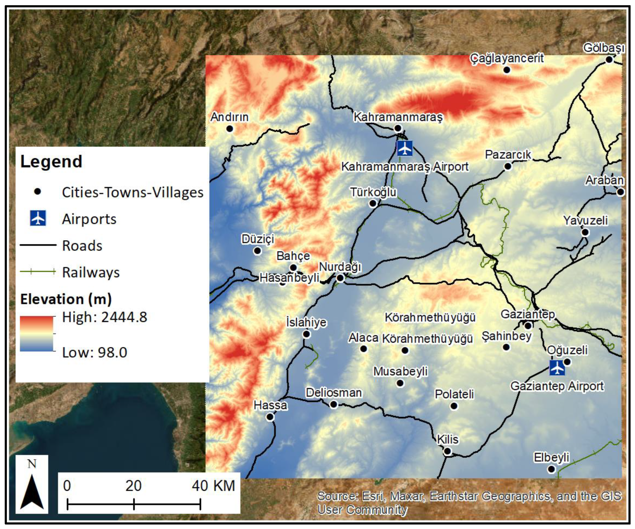
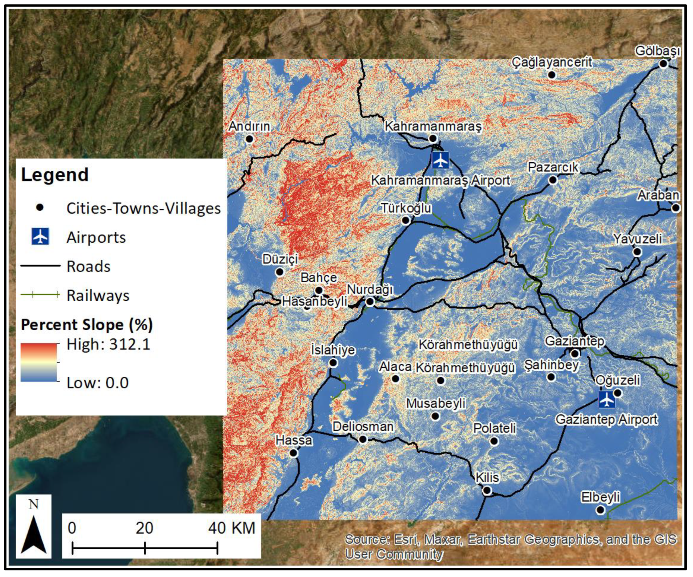
3. Urban Setting of Gaziantep and Kahramanmaraş

4. The Seismic Event
5. Data and Methodology
5.1. Data
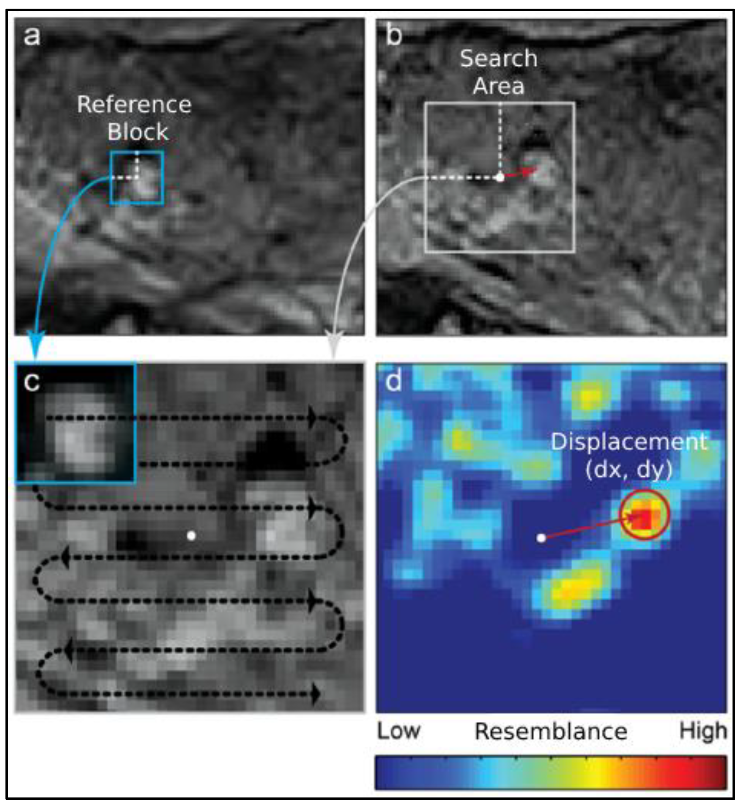
5.2. Methodology
6. Results
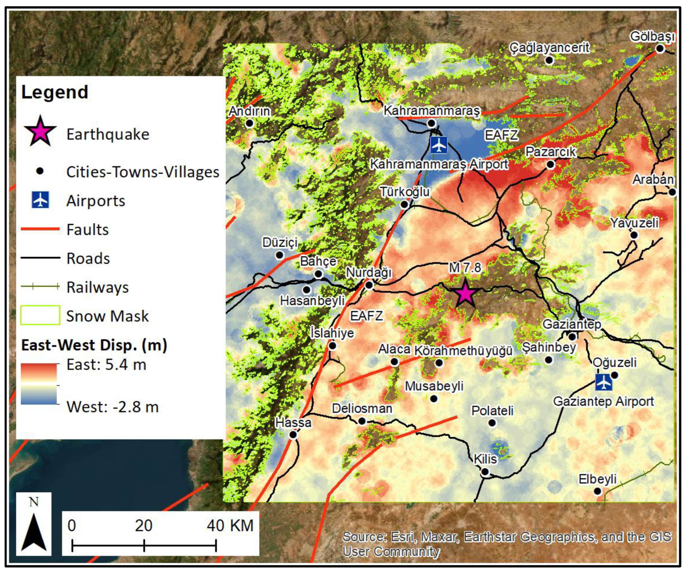
6.1. East–West Displacement
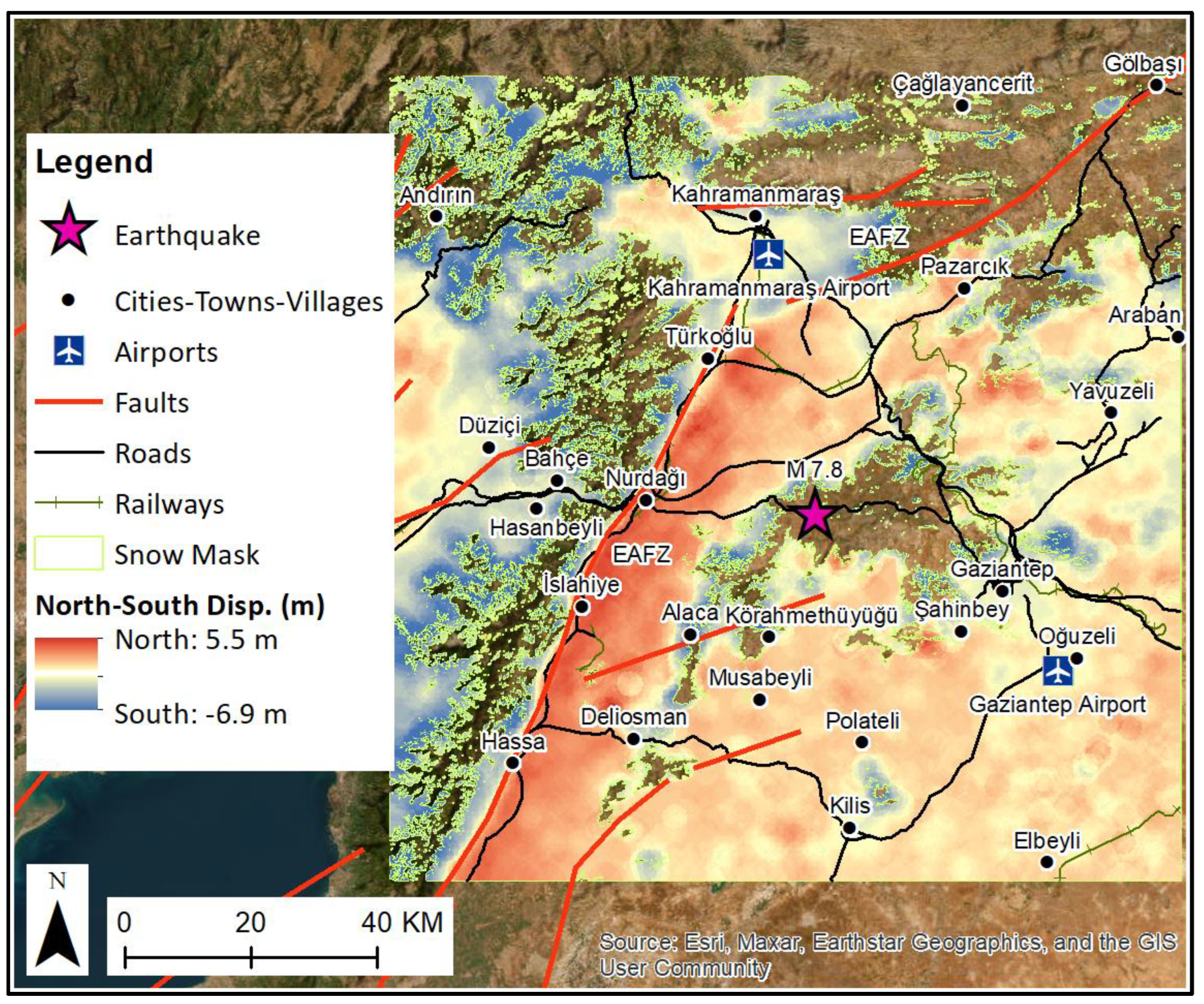
6.2. North–South Displacement
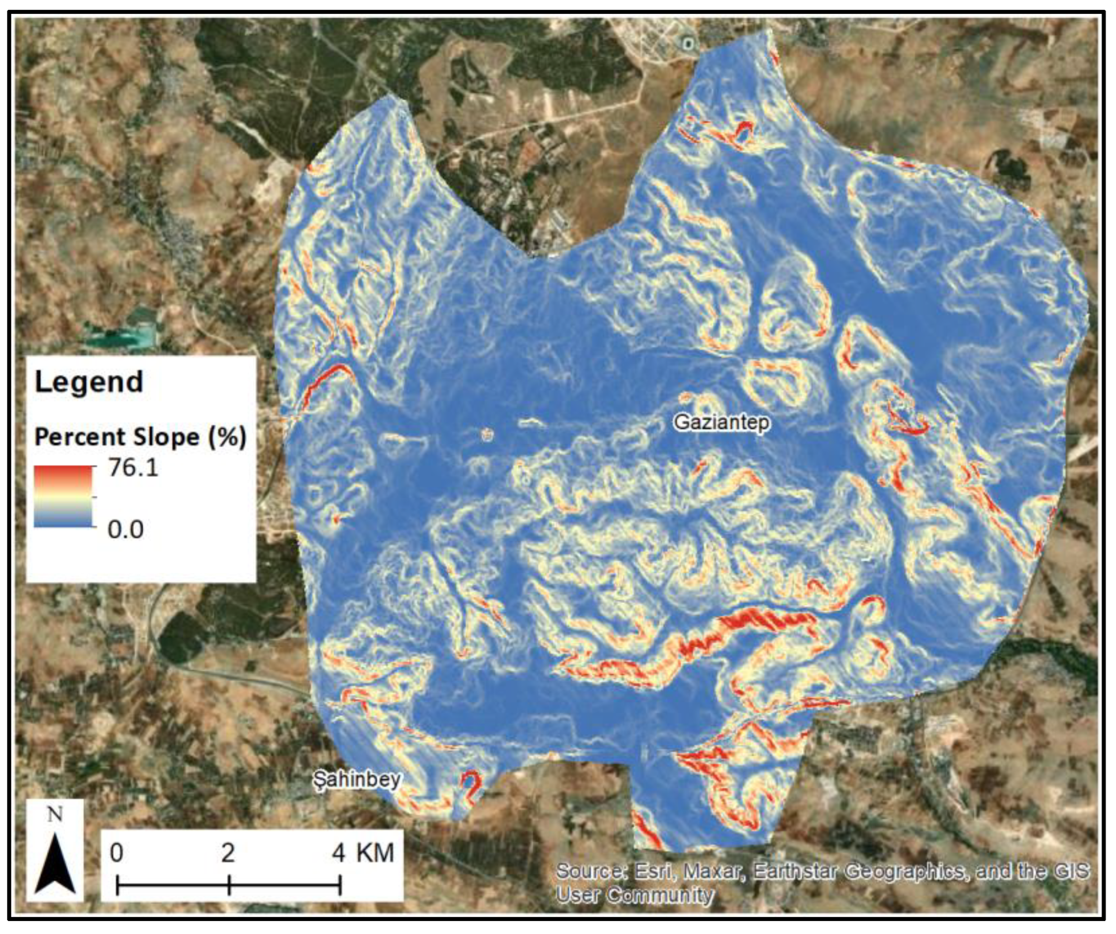
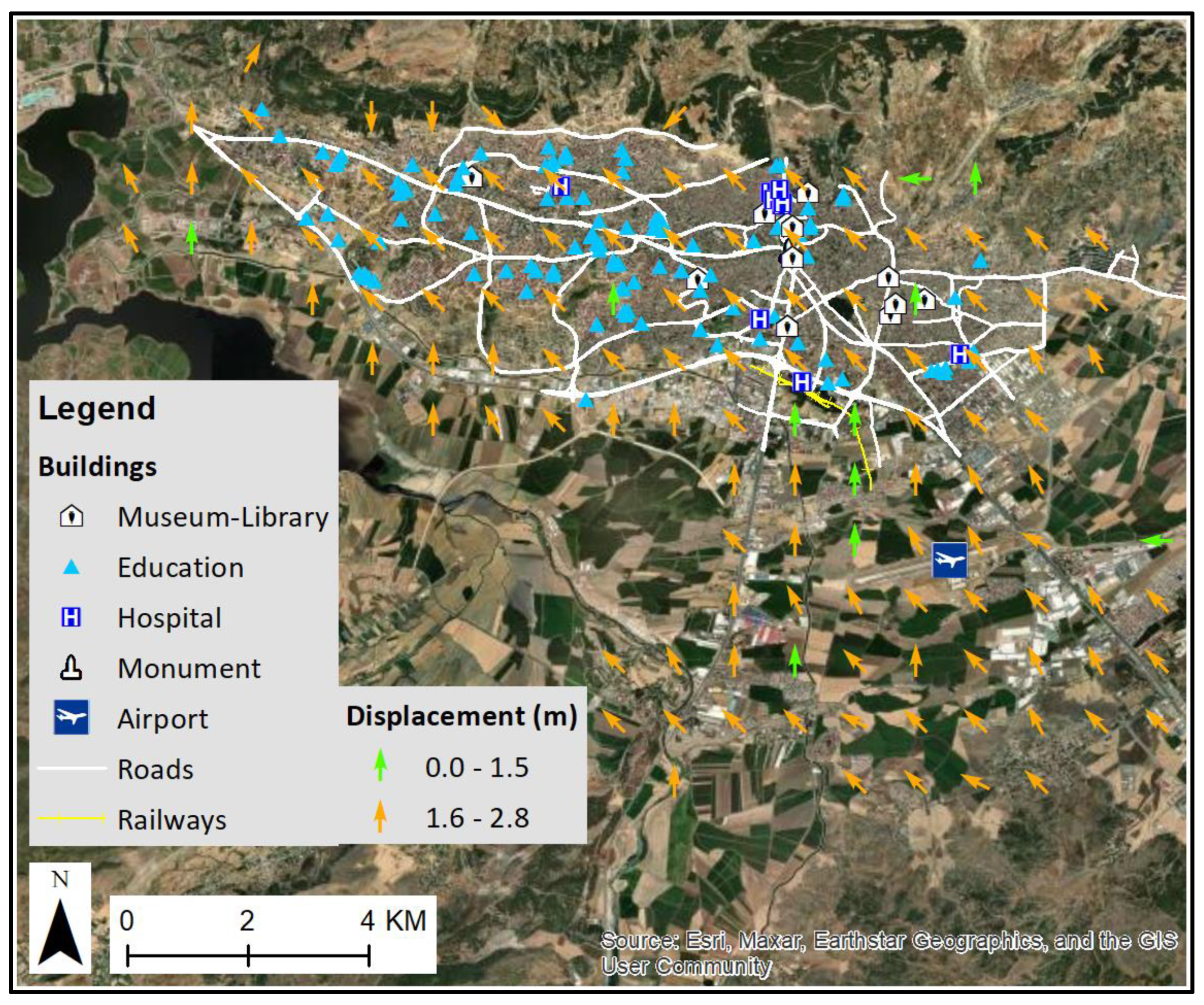
6.3. Displacement and Critical Exposure in Gaziantep City
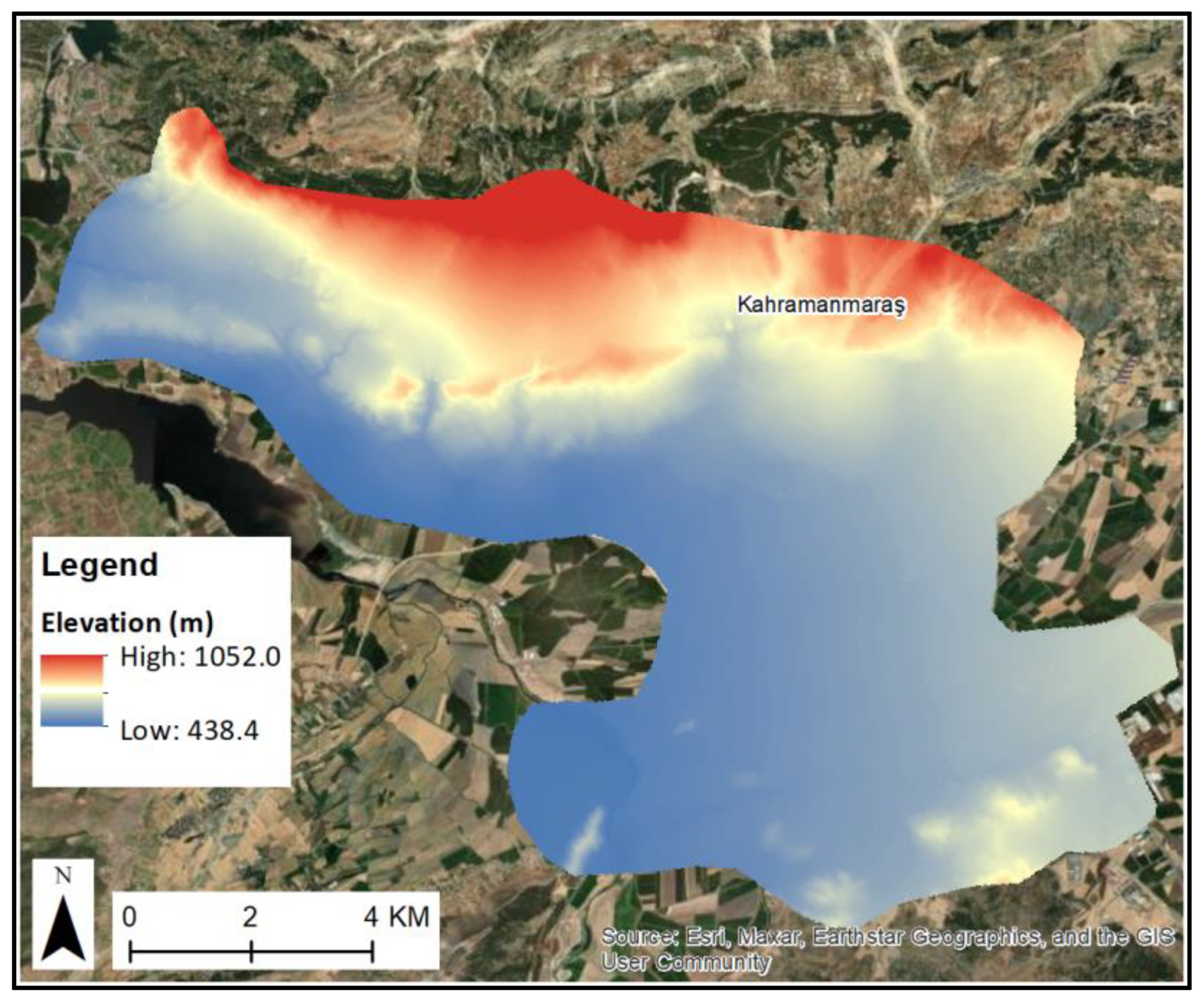
6.4. Displacement and Critical Exposure in Kahramanmaraş City
7. Discussion and Conclusions
Author Contributions
Funding
Data Availability Statement
Acknowledgments
Conflicts of Interest
Data Sources
References
- U.S. Geological Survey. The Science of Earthquakes. Available online: https://www.usgs.gov/programs/earthquake-hazards/science-earthquakes (accessed on 3 March 2023).
- Ferretti, A. Satellite InSAR Data: Reservoir Monitoring from Space; EAGE Publications: Kosterijland, The Netherlands, 2014. [Google Scholar] [CrossRef]
- Stumpf, A.; Malet, J.P.; Puissant, A.; Travelletti, J. Monitoring of Earth Surface Motion and Geomorphologic Processes by Optical Image Correlation. Land Surface Remote Sensing; Elsevier: Amsterdam, The Netherlands, 2016; pp. 147–190. ISBN 9781785481055. [Google Scholar] [CrossRef]
- UiO Department of Geosciences. Image Correlation Software CIAS. Available online: http://www.mn.uio.no/geo/english/research/projects/icemass/cias/ (accessed on 5 March 2023).
- Debella-Gilo, M.; Kääb, A. Sub-pixel precision image matching for measuring surface displacements on mass movements using normalized cross-correlation. Remote Sens. Environ. 2011, 115, 130–142. [Google Scholar] [CrossRef]
- Heid, T.; Kääb, A. Evaluation of existing image matching methods for deriving glacier surface displacements globally from optical satellite imagery. Remote Sens. Environ. 2012, 118, 339–355. [Google Scholar] [CrossRef]
- Kääb, A.; Vollmer, M. Surface geometry, thickness changes and flow fields on creeping mountain permafrost: Automatic extraction by digital image analysis. Permafr. Periglac. Process. 2000, 11, 315–326. [Google Scholar] [CrossRef]
- Smithsonian Institution. 7.8-Magnitude Earthquake Felt ‘Like the Apocalypse’ in Turkey and Syria. Available online: https://www.smithsonianmag.com/smart-news/78-magnitude-earthquake-felt-like-the-apocalypse-in-turkey-and-syria-180981587/ (accessed on 3 March 2023).
- African/Arabian Tectonic Plates. The Arabian Plate. Available online: https://africa-arabia-plate.weebly.com/arabian-plate.html (accessed on 4 March 2023).
- Mascle, J.; Benkhelil, J.; Bellaiche, G.; Zitter, T.; Woodside, J.; Loncke, L. Prismed II Scientific Party, Marine geologic evidence for a Levantine–Sinai plate, a new piece of the Mediterranean puzzle. Geology 2000, 28, 779–782. [Google Scholar] [CrossRef]
- Mahmoud, Y.; Masson, F.; Meghraoui, M.; Cakir, Z.; Alchalbi, A.; Yavasoglu, H.; Yönlü, O.; Daoud, M.; Ergintav, S.; Inan, S. Kinematic study at the junction of the East Anatolian fault and the Dead Sea fault from GPS measurements. J. Geo-Dyn. 2013, 67, 30–39. [Google Scholar] [CrossRef]
- USGS. The 2023 Kahramanmaras, Turkey Earthquake Sequence. Available online: https://earthquake.usgs.gov/storymap/index-turkey2023.html?utm_source=hootsuite (accessed on 5 March 2023).
- Reilinger, R.E.; McClusky, S.C.; Oral, M.B.; King, R.W.; Toksoz, M.N.; Barka, A.A.; Kinik, I.; Lenk, O.; Sanli, I. Global Posi-tioning System measurements of present-day crustal movements in the Arabia-Africa-Eurasia plate collision zone. J. Geophys. Res. 1997, 102, 9983–9999. [Google Scholar] [CrossRef]
- Encyclopædia Britannica. Aleppo Earthquake of 1138. Available online: https://www.britannica.com/event/Aleppo-earthquake-of-1138 (accessed on 26 April 2023).
- Darawcheh, R.; Abdul-wahed, M.K.; Hasan, A. The 13th-August-1822 Aleppo Earthquake: Implications for the Seismic Hazard Assessment at the Antakia Triple Junction. In On Significant Applications of Geophysical Methods. CAJG 2018. Advances in Science, Technology & Innovation; Sundararajan, N., Eshagh, M., Saibi, H., Meghraoui, M., Al-Garni, M., Giroux, B., Eds.; Springer: Cham, Switzerland, 2019. [Google Scholar] [CrossRef]
- Lekkas, E.; Carydis, P.; Vassilakis, E.; Mavroulis, S.; Argyropoulos, I.; Sarantopoulou, A.; Mavrouli, M.; Konsolaki, A.; Gogou, M.; Katsetsiadou, K.N.; et al. The 6 February 6 2023 Turkey-Syria Earthquakes. In Newsletter of Environmental, Disaster and Crises Management Strategies; National and Kapodistrian University of Athens: Athens, Greece, 2023; p. 29. ISSN 2653-9454. [Google Scholar] [CrossRef]
- British Geological Survey. The Kahraman Maraş Earthquake Sequence, Turkey/Syria. Available online: https://www.bgs.ac.uk/news/the-kahraman-maras-earthquake-sequence-turkey-syria/ (accessed on 5 March 2023).
- Citypopulation. Population Statistics, Charts and Map. Available online: https://www.citypopulation.de/en/turkey/admin/ (accessed on 3 March 2023).
- Encyclopædia Britannica. Kahramanmaraş. Available online: https://www.britannica.com/place/Kahramanmaras (accessed on 3 March 2023).
- GSNL. Kahramanmaraş Event Supersite. Available online: https://geo-gsnl.org/supersites/event-supersites/active-event-supersites/kahramanmaras-event-supersite/ (accessed on 9 June 2023).
- European-Mediterranean Seismological Centre. Available online: https://www.emsc-csem.org/#2 (accessed on 16 May 2023).
- ESA. Sentinel-2 Overview. Available online: https://sentinel.esa.int/web/sentinel/missions/sentinel-2/overview (accessed on 5 March 2023).
- ESA. Sentinel-2 Product Types. Available online: https://sentinel.esa.int/web/sentinel/user-guides/sentinel-2-msi/product-types (accessed on 5 March 2023).
- ESA. Sentinel Online, Level-2A Product. Available online: https://sentinel.esa.int/web/sentinel/user-guides/sentinel-2-msi/product-types/level-2a (accessed on 5 March 2023).
- Meteostat. Gaziantep|Weather History & Climate. Available online: https://meteostat.net/en/station/17260?t=2023-01-25/2023-02-09 (accessed on 9 June 2023).
- Meteostat. Kahramanmaras|Weather History & Climate. Available online: https://meteostat.net/en/station/17255?t=2023-01-25/2023-02-09 (accessed on 9 June 2023).
- Copernicus. Copernicus Emergency Management Service–Mapping. Available online: https://emergency.copernicus.eu/mapping/copernicus-emergency-management-service#zoom=4&lat=33.51964&lon=44.12109&layers=0BT00 (accessed on 5 March 2023).
- Uhe, P.; Hawker, L.; Paulo, L.; Sosa, J.; Sampson, C.; Neal, J. FABDEM-A 30m Global Map of Elevation with Forests and Buildings Removed. In Proceedings of the EGU General Assembly 2022, Vienna, Austria, 23–27 May 2022. [Google Scholar] [CrossRef]
- ForM@Ter–EOST. Terrain Displacement from the Turkiye-Syria Earthquakes of February 6, 2023 Obtained with the GDM-OPT-ETQ Service Applied on Sentinel-2 Optical Imagery; ForM@Ter–EOST: 2023. Available online: https://doi.data-terra.u-strasbg.fr/GDM_OPT_Turkey_Syria/ (accessed on 9 June 2023).
- Ou, Q.; Lazecky, M.; Watson, C.S.; Maghsoudi, Y.; Wright, T. 3D Displacements and Strain from the 2023 February Turkey Earthquakes, Version 1; NERC EDS Centre for Environmental Data Analysis: Didcot, UK, 2023. [Google Scholar] [CrossRef]





| Earthquake | Date | Magnitude |
|---|---|---|
| 1 | 6 February 2023 | 5.1 |
| 2 | 6 February 2023 | 5.6 |
| 3 | 6 February 2023 | 6.7 |
| 4 | 6 February 2023 | 5.0 |
| 5 | 6 February 2023 | 5.2 |
| 6 | 6 February 2023 | 5.7 |
| 7 | 6 February 2023 | 5.3 |
| 8 | 6 February 2023 | 5.1 |
| 9 | 6 February 2023 | 5.0 |
| 10 | 6 February 2023 | 5.0 |
| 11 | 6 February 2023 | 6.0 |
| 12 | 6 February 2023 | 5.0 |
| 13 | 7 February 2023 | 5.0 |
| 14 | 7 February 2023 | 5.5 |
| 15 | 7 February 2023 | 5.3 |
| 16 | 8 February 2023 | 5.1 |
| Product | Satellite | Date |
|---|---|---|
| Pre-event Image 1 | Sentinel-2B | 25 January 2023 |
| Pre-event Image 2 | Sentinel-2B | 25 January 2023 |
| Pre-event Image 3 | Sentinel-2B | 25 January2023 |
| Pre-event Image 4 | Sentinel-2B | 25 January 2023 |
| Post-event Image 1 | Sentinel-2A | 9 February 2023 |
| Post-event Image 2 | Sentinel-2A | 9 February 2023 |
| Post-event Image 3 | Sentinel-2A | 9 February 2023 |
| Post-event Image 4 | Sentinel-2A | 9 February 2023 |
| Direction | Displacement (m) | Area (km2) |
|---|---|---|
| East | 2.0−5.4 | 190.51 |
| East | 0.0−2.0 | 8162.28 |
| West | 0.0−2.0 | 2659.55 |
| West | 2.0−2.8 | 11.40 |
| Direction | Displacement (m) | Area (km2) |
|---|---|---|
| North | 2.0−5.5 | 5293.02 |
| North | 0.0−2.0 | 4315.48 |
| South | 0.0−2.0 | 1075.97 |
| South | 2.0−6.9 | 339.27 |
Disclaimer/Publisher’s Note: The statements, opinions and data contained in all publications are solely those of the individual author(s) and contributor(s) and not of MDPI and/or the editor(s). MDPI and/or the editor(s) disclaim responsibility for any injury to people or property resulting from any ideas, methods, instructions or products referred to in the content. |
© 2023 by the authors. Licensee MDPI, Basel, Switzerland. This article is an open access article distributed under the terms and conditions of the Creative Commons Attribution (CC BY) license (https://creativecommons.org/licenses/by/4.0/).
Share and Cite
Gkougkoustamos, I.; Krassakis, P.; Kalogeropoulou, G.; Parcharidis, I. Correlation of Ground Deformation Induced by the 6 February 2023 M7.8 and M7.5 Earthquakes in Turkey Inferred by Sentinel-2 and Critical Exposure in Gaziantep and Kahramanmaraş Cities. GeoHazards 2023, 4, 267-285. https://doi.org/10.3390/geohazards4030015
Gkougkoustamos I, Krassakis P, Kalogeropoulou G, Parcharidis I. Correlation of Ground Deformation Induced by the 6 February 2023 M7.8 and M7.5 Earthquakes in Turkey Inferred by Sentinel-2 and Critical Exposure in Gaziantep and Kahramanmaraş Cities. GeoHazards. 2023; 4(3):267-285. https://doi.org/10.3390/geohazards4030015
Chicago/Turabian StyleGkougkoustamos, Ioannis, Pavlos Krassakis, Georgia Kalogeropoulou, and Issaak Parcharidis. 2023. "Correlation of Ground Deformation Induced by the 6 February 2023 M7.8 and M7.5 Earthquakes in Turkey Inferred by Sentinel-2 and Critical Exposure in Gaziantep and Kahramanmaraş Cities" GeoHazards 4, no. 3: 267-285. https://doi.org/10.3390/geohazards4030015
APA StyleGkougkoustamos, I., Krassakis, P., Kalogeropoulou, G., & Parcharidis, I. (2023). Correlation of Ground Deformation Induced by the 6 February 2023 M7.8 and M7.5 Earthquakes in Turkey Inferred by Sentinel-2 and Critical Exposure in Gaziantep and Kahramanmaraş Cities. GeoHazards, 4(3), 267-285. https://doi.org/10.3390/geohazards4030015


