1. Introduction
Urban design is important for fostering sustainable and resilient cities capable of meeting the diverse needs of their inhabitants. This can be achieved by designing and regulating land use, infrastructure, and public services to create harmonious, efficient, and resilient urban environments [
1]. Thus, effective urban design considers the optimal utilization of available resources in order to reduce environmental impact and respect the architectural landscape, providing resilience against hazards of climate change such as extreme heat, heavy rain, and flooding while improves health, wellbeing, and quality of life for residents [
2,
3]. In addition, efficient urban design mitigates urban sprawl, manages traffic congestion, and minimizes traffic accidents. As a result, an urban planner must consider several socioeconomic parameters [
4,
5] related to social equity, economic growth, and environmental protection in order to provide environments that are livable, inclusive, and capable of adapting to future challenges such as climate change or population growth in the city environment.
Even if an urban intervention meets the aforementioned criteria, it may not be accepted by the public [
6]. In this case, citizens can downgrade the benefits of the intervention by damaging structures as a reaction to express their disapproval [
7]. Co-participation, co-design, and co-creation in urban design processes are essential to foster inclusive, democratic, decentralized, and responsive urban environments. These collaborative approaches ensure that the voices and needs of multi-diverse community stakeholders (i.e., citizens, authorities, architects, urban planners, policymakers, etc.) are heard and considered in the planning process, leading to more equitable and user-centered urban solutions [
8].
The participation of residents, local businesses, and other related stakeholders in the decision-making process can help urban designers to harness local knowledge and creativity, resulting in innovative and contextually urban design solutions capable of satisfying the majority of the local community. Moreover, co-design and co-creation enhance transparency and trust between the public community (i.e., citizens, local businesses, etc.) and the planners’ group (i.e., planners, authorities, policymakers, etc.), providing a feeling and sense of ownership and accountability for the outcome solution(s). This participatory approach leads to more socially sustainable urban development and promotes civic participation, empowering communities to actively shape their living environments and ultimately fostering a stronger sense of community and resilience.
Although the benefits of co-participation, co-design, and co-creation in urban design are recognizable, their application faces several significant challenges in contemporary settings [
9]. A major obstacle is the lack of adequate communication and understanding between experts on the one hand and multi-diverse communities and stakeholders on the other. In particular, urban designers use technical jargon and complex processes that are usually not understood by the general public, leading to disengagement and a sense of exclusion. Furthermore, socioeconomic disparities can hinder participation because marginalized communities may lack the time, resources, or platforms to effectively express their opinions.
Bureaucratic inertia and rigid regulatory frameworks can also stifle innovation and responsiveness, making the incorporation of meaningful community feedback difficult to collect. Political dynamics and vested interests play an additional role, as powerful stakeholders can dominate the planning process and marginalize less influential opinions [
10]. Finally, the sheer scale and complexity of urban issues can make coordinated participation a challenge [
11], as it requires substantial effort to organize, manage, and synthesize input from a representative number of participants. The limitations mentioned above [
12] highlight the need to develop and suggest approaches (i.e., tools and methodologies) which provide inclusive, transparency, and flexibility to urban design procedures in a way that promotes lowering of barriers by better accommodating and empowering all community members.
This work presents a gamified solution leveraging open-source geospatial data and software to address accessibility challenges in urban design participation. Many digital tools exclude elderly users or require physical attendance and technical expertise, resulting in limited public engagement. The euPOLIS game overcomes these barriers by offering a freely available cross-platform tool with intuitive mechanics inspired by classic video games. The game is easily downloadable and installable on any device and requires no specialized skills or equipment, making urban design participation more inclusive and accessible to diverse user groups.
To explore the potential of the proposed methodology, impressions and feedback were gathered from 30 individuals who voluntarily engaged with the euPOLIS game during the TNOC 2024 Festival. Rather than being a structured trial with a predefined participant group, this open-ended approach allowed attendees to freely experience the tool and share their thoughts through a short questionnaire (
Appendix A). The responses provided valuable insights into public engagement with gamified urban design solutions, with the majority of participants expressing the opinion that such tools can serve as an interactive and enjoyable means of fostering co-participation, co-design, and co-creation in urban planning.
The rest of this paper is organized as follows: (a)
Section 2 presents the current state-of-the-art approaches; (b)
Section 3 provides information related to the game’s development; (c)
Section 4 presents the results of the workshop event; and (d)
Section 6 concludes this work.
2. The Current State-of-the-Art Approaches
Several approaches regarding the enhancement of co-participation, co-design, and co-creation have been proposed and investigated in the past years. Indicative examples are the following: (a) the use of digital tools and platforms; (b) participatory design workshops; (c) gamification and simulation applications; and (d) social media and mobile applications. These approaches not only increase citizens’ participation in urban design processes, they also help in urban design management. The following paragraphs present current state-of-the-art approaches based on a literature review.
Stelzle et al. [
13] investigated decision-making in co-design contexts by developing the U_CODE (Urban COllective Design Environment) platform, which allows for simultaneous participation by a huge number of participants. This tool includes several criteria settings, such as initial brief, co-brief, co-design, design competition, sentiment analysis, ranking/voting differentiation, and integration. The European Digital Platform [
14] is another example of a tool that supports co-design in urban design applications. Collaboration between citizens and administration groups is achieved at four distinct levels of interaction: (a) self-organization; (b) information sharing (c) interaction; and (d) co-production.
Such platforms are usually developed on the basis of Geographic Information Systems (GIS) [
15], which provides advanced features such as interactive mapping for online participation platforms (i.e., coUrbanize [
16] and Commonplace [
17]). These tools permit broader and more inclusive participation that enables community members to visualize the suggested interventions and provide feedback. In addition, these tools allow for active participation in planning processes from anywhere via online access, increasing accessibility and convenience (i.e., e-participation) [
18]. A strong limitation of e-participation is the creation of challenges and barriers for the majority of elderly people, who may not be as good at using such technologies compared to other groups [
19].
In order to include elderly people in the urban design co-participation, co-creation, and co-design processes, one suggestion is to utilize participatory practices such as workshops [
20]. The work of Lee et al. [
21] described three types of participation: (a)
public participation, which refers to participation involving experts (abstract space); (b)
community participation, which refers to non-experts (concrete space); and (c)
design participation, which involves both experts and non-experts (collaboration). They also introduced other participation approaches that involve common practices between experts and non-experts, such as the creation of a common language (i.e., terminology) that can empower games and design challenges for community workshops.
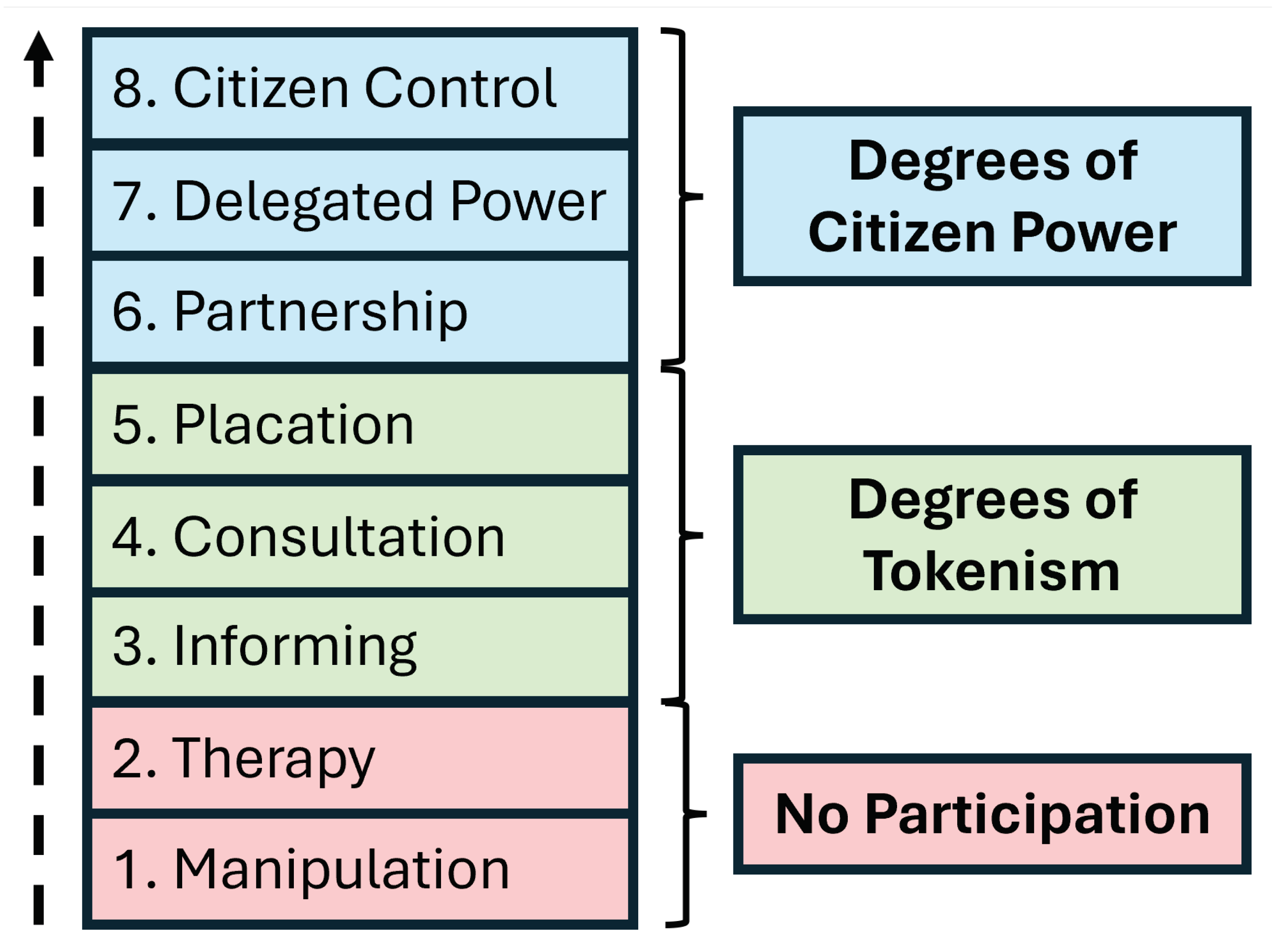
According to Arnstein’s ladder [
22] of participation (
Figure 1), several layers of participation [
23] can be achieved by involving different stakeholders. As an example, the work of Nochta et al. [
24] investigated the concepts of co-production and co-development in urban design by organizing three workshops. These workshops all involved small groups of 10–15 stakeholders from different domains, such as local and regional public sector bodies and representatives of different departments and units from built environment sectors. Such workshops can utilize a wide range of stakeholders (i.e., elderly, young, experts, non-experts, etc.) and technologies (i.e., digital twins, gamification, traditional paper mockup creation, etc.), including interactive games for co-design [
25].
The Zurich digital twin [
26] is an indicative example of the applicability of digital 3D technologies in urban design procedures. Digital twins can be used effectively for multiscale intervention planning, from renovating a room [
27] to visualizing possible transformations of a square [
28]. Digital twins provide high-fidelity models and interaction [
29]. A robust architecture [
30] utilizing this technology as a co-participatory, co-design, and co-creation tool might consist of the following steps: (a) data acquisition; (b) digital modeling; (c) city simulation; and (d) offline/online participation.
Minecraft is an indicative example of a simulation game that can be used to enhance participation in urban design [
31,
32,
33]. This game ha been shown to inspire groups consisting of children [
34], teenagers [
35], and adults [
36] to participate in offline or online workshops. Game engines (i.e., Unreal Engine, Unity) can provide an interactive environment for design ideas, either inside the engine’s environment or in a packaged single-player or multiplayer video game [
37,
38]. All of these tools can be further empowered by deploying virtual reality (VR), augmented reality (AR), or expanded reality (XR) capabilities to an improved and interactive environment [
39].
Finally, social media and mobile applications [
40] can be deployed for both in situ (offline) and online workshops to share information, chat, or vote. The use of the correct equipment [
41], such as on-site cameras, GPS, mobile phones, VR/AR glasses, etc., creates an interactive environment that allows for the in situ visualization of the suggested interventions. Especially for elderly people, VR/AR technologies [
42] can be a fun experience that can inspire them to participate in urban design through co-design and co-creation events.
A complete summarization of the advantages and limitations of the aforementioned technologies is provided in
Table 1.
Contribution
This work investigates the acceptability of a simulator game on the part of both urban designers and the general public. The game was developed under the EU Horizon-2020 euPOLIS project [
43]; thus, it is named the euPOLIS Game. This game was developed as an interactive simulation tool intended for increasing the number of participant in urban design via the linked concepts of co-participation, co-design, and co-creation, and is equipped with several capabilities. It is composed by two distinct gameplay modes, aiming to inspire both citizens and experts to collaborate in proposing and evaluating their own nature-based solutions. The effectiveness of the game was tested at the 2024 TNOC (The Nature of Cities) Festival in Berlin, Germany [
44], where a group of 30 people participated by playing the game and provided feedback by answering a small questionnaire. The participants consisted of different groups in terms of age, academic education, expertise, and experiences, composing a diversity of opinions. Thus, the contributions of this research are as summarized below:
We use a serious game simulator completely developed with free and open-source data and technologies (i.e., open GIS data and software) as an urban design tool.
We investigate the usability and acceptance of this game by sharing it with several people, including both experts and non-experts.
Our collected feedback indicates the importance and limitations of this approach.
By analyzing the comments of the participants, we provide important insight for further development and research related to co-participation, co-design, and co-creation practices in urban design intended for democratizing and decentralizing the urban design processes.
Overall, the whole proposed methodology can help to improve urban design management and policies through the adoption of more inclusive strategies.
3. Proposed Methodology
The proposed methodology outlines the development and application of the euPOLIS game as a participatory tool for urban design. The approach leverages open-source geospatial data, digital twin technology, and gamification principles to foster collaboration between experts and non-experts. The methodology is structured to include two distinct gameplay modes: Feedback Mode, designed for evaluating pre-existing solutions, and Building Mode, aimed at enabling users to design and visualize their own interventions. This section provides a detailed description of the development process, including technical implementation, game mechanics, and how the game integrates the co-participation, co-design, and co-creation framework.
3.1. The euPOLIS Game Development Process
EuPOLIS is an EU Horizon-2020 funded project [
43] that supports the development of urban environments based on NBS for increasing citizens’ health and wellbeing. The euPOLIS project integrates its suggested solutions in four European cities: (a) Piraeus, Greece; (b) Lodz, Poland; (c) Belgrade, Serbia; and (d) Gladsaxe, Denmark. The common factor of these cities is their lack of quality green spaces in certain areas, leading to citizens avoiding these areas. Thus, the following question is formulated: How can the urban environment be redesigned using nature-based solutions in such a way that citizens accept it and start visiting these areas?
To answer this question, the euPOLIS game [
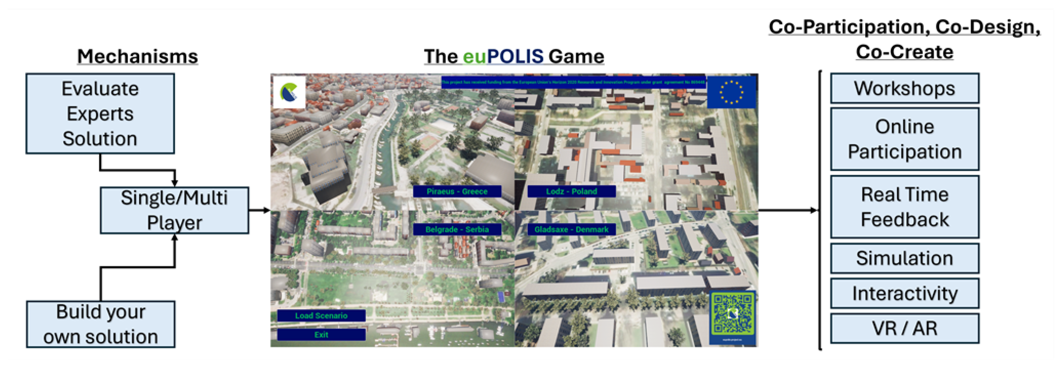
45] was developed as a tool for communication between the several stakeholders, who can be both experts or non-experts. For testing and demonstrating the capabilities of the proposed methodology, the euPOLIS game supports two different and distinct modes, with the possibility of further expansion in future updates. In the first mode, called “Feedback Mode”, the main purpose is to ask the player (i.e., citizens or other designers) to evaluate an existing solution. The second mode, called “Building Mode”, provides the necessary tools for players to create their own solutions. Currently, the game supports only offline playing; however, online capabilities can be supported in future updates. Thus, the euPOLIS game can be used for in situ participation workshops [
46] to promote co-participatory, co-design, and co-creative urban design inside a fun and interactive VR/AR digital environment.
Figure 2 illustrates the complete game framework as described above.
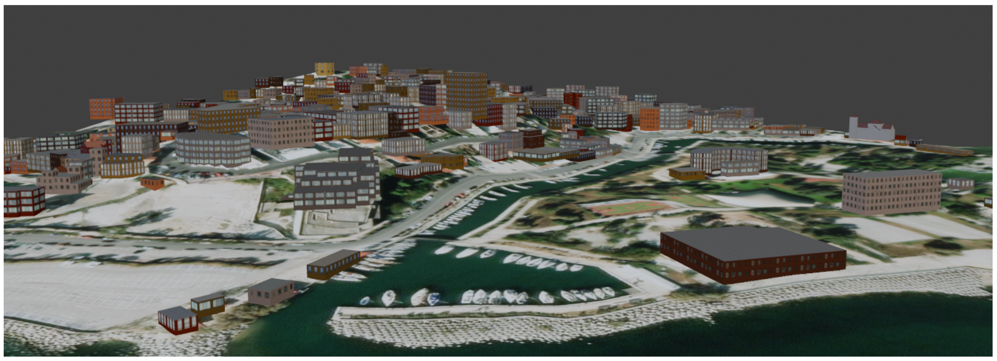
The euPOLIS game was developed utilizing open GIS data, Blender, Unreal Engine 5, and the C++ programming language to create meshes and implement game mechanics. The landscape mesh model, which functions as a digital twin of the intervention area, was generated within Blender using the Blender-OSM plugin. This process involves three key steps: (a) selecting and generating the terrain model; (b) applying texture overlays; and (c) integrating 3D building information.
Figure 3 visually outlines this workflow, while
Figure 4 showcases an example of the digital twin for the Dilaveri Coast region of the city of Piraeus, Greece, one of the four case study areas within the euPOLIS project.
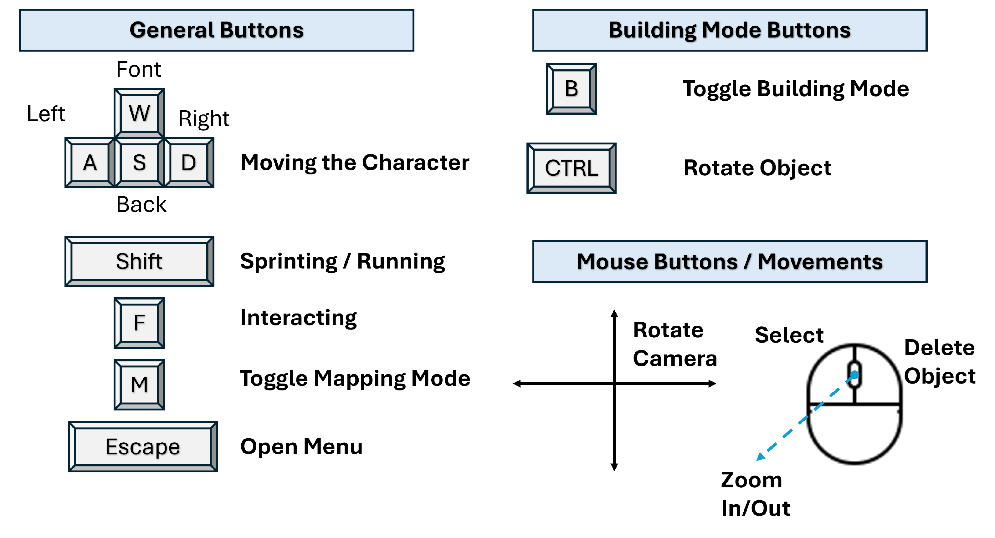
The final DT model is exported as an FBX file format and imported to the game engine (i.e., UE5), where the game is developed according to the needs of the project. For the euPOLIS game, the aforementioned process was repeated four times to generate digital twins for all the areas of interest. These meshes were imported to UE5 environment, where the euPOLIS game was developed using the C++ programming language for the different mechanics (i.e., walk, run, add/remove features to/from scene). In addition, UE5 supports advance lighting systems (e.g., Lumen); in combination with additional mesh settings such as Nanite, it is quite intuitive to create a realistic 3D scene.
Figure 5 presents the key mapping of the game; for testing the game there is a download link at [
45]. The game is funded by the EU and has been developed by the authors of this manuscript. It is a free-to-play game and does not require any permission or license for downloading or distributing the material, as it is part of the dissemination activities of the euPOLIS project.
Comparison of euPOLIS Game Development with State-of-the-Art
The development of the euPOLIS game was strictly restricted to Open GIS data and free and open-source tools; thus, the euPOLIS game is a zero-cost production in terms of material acquisition, 3D-Mesh/BIM generation, and code development. Our previous work [
28] has thoroughly explained the technologies used for generating the BIM models and retrieval of the necessary material for the development of such a game using Unreal Engine 5. At this point, it is worth mentioning that the inspiration behind the euPOLIS game development considers game development franchises of several genres (i.e., simulation, survival, action-adventure, etc.) that take place in exact copies of existing cities.
Usually, the production of such games involves a team of many people and the process of generating of the city model is expensive. In contrast, the euPOLIS game development approach investigated the generation of a low-cost BIM production completely related to Open GIS data as an early assistive tool in the production of urban planning solutions by both experts and non-experts.
Table 2 provides a comparison between the development process of the euPOLIS game and the approaches used in state-of-the-art game development franchises.
3.2. Feedback Mode
The Feedback Mode is one of the two modes of the euPOLIS game. In this mode, the player navigates a demo solution predesigned by a team of experts. Its primary aim is to achieve communication between the experts (i.e., the urban designers who proposed the solution) and the general public (i.e., citizens, visitors, etc.). The player navigates the demo solution and “feels” the intervention planning inside a virtual environment. When the player is ready, he/she can visit certain points where a Non-Playable Character (NPC) will ask whther the player likes the solution, providing three different options for answer: (a) Yes, the player likes the solution; (b) No, the player dislikes the solution; and (c) I (the player) need more time and will answer later. In the case of an (a) or (b) answer, the game stores the player’s response for that checkpoint and the NPC will not ask for feedback again. The third option retains the opportunity to the player to renavigate the solution and answer when ready.
Figure 6 illustrates a sample from the game’s Feedback Mode. Panel 1 in
Figure 6 illustrates the starting position of the player when selecting the option to navigate over Dilaveri Coast, while Panel 2 shows the map of the area, with feedback points marked by blue bubbles. Panel 3 shows an illustrative example in which the second pocket park has been designed by experts. Finally, Panel 4 of
Figure 6 shows the NPC asking the user for feedback. At this point, it is important to note that the feedback can be provided in a way that supports the expert team’s project. For this reason, it is necessary to define from the beginning a feedback system which applies to the project, as this system needs to be developed during the game’s creation. For the euPOLIS game, two feedback systems where provided, the first consisting of a binary (Yes/No) question and the second of a QR code that can be scanned using a mobile phone. This QR code forwards the players to a questionnaire that has been designed to collect feedback related to the specific demonstration solution.
3.3. Building Mode
The second gameplay mode supported by the euPOLIS game is called Building Mode. The main purpose of this mode is to provide an interactive environment for building and visualizing different solutions. The player has to choose among several objects (i.e., trees, benches, etc.) that are provided as a predetermined pool related to the final intervention theme. For instance, if the intended area of the intervention is to be a park, the player is given park-related objects. Moreover, the player can rotate the z-axis (yaw rotation) of the objects to place them as preferred. Objects can also be erased in case they are mistakenly positioned.
This gameplay design was inspired by several different simulation-like games, including Minecraft, Palworld, and The Sims, in which the player has the ability to build a base for various reasons. However, the euPOLIS game aims for use as a tool for planning interventions rather than as a simulation tool that can be used in education, like Minecraft [
48]. This is achieved by providing a digital twin of a real area where the player (expert or non-expert) can build a solution.
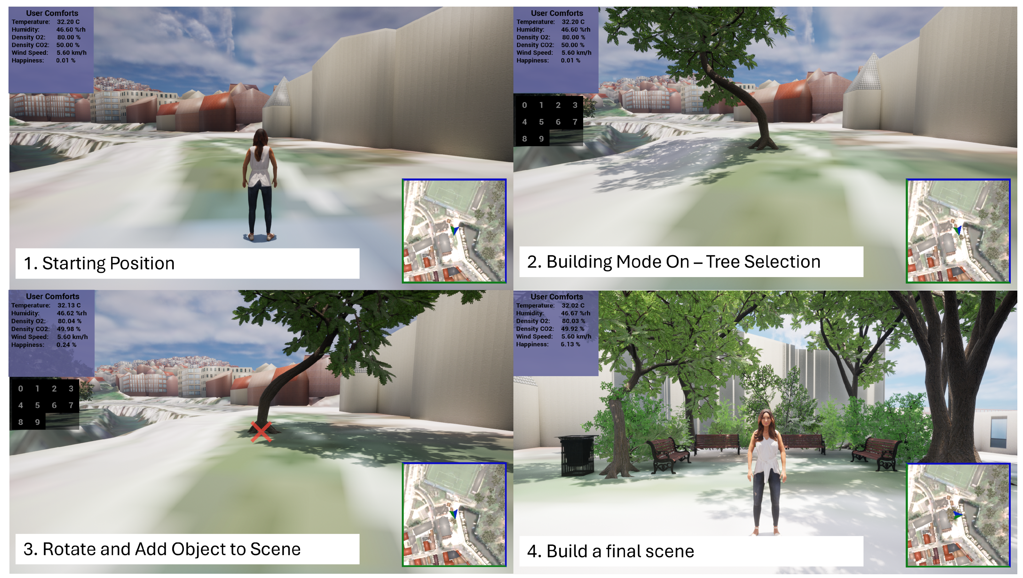
Figure 7 illustrates the four-step process of building a small scene in the Dilaveri Coast region.
The fist step indicates the initial position of the player when Building Mode has been selected. In the second image, the player has toggled Building Mode; the game permits the player to select an object of interest and add it to the screen. The player can change the z-rotation of the object and place it as desired, which is illustrated in the third image. By repeating the the two previous steps, the player designs a final scene, as shown in the fourth image. At this point, it is worth mentioning that the player receives real-time in-game feedback about the selections in the form of a score system named “User Comforts”.
3.4. User Comforts Metric System
To provide real-time feedback to the player in both modes, a real-time evaluation metric system named “User Comforts” is introduced. This system is currently at a basic level, using a linear equation (Equation (
1)) to calculate the impact of the scene objects on different parameters. The “User Comforts” feedback approach considers different climate parameters such as temperature, humidity, density of CO
2, density of O
2, and wind speed to describe the benefits of building environmentally friendly solutions. The player can add other objects to the scene such as canteens, tables, and chairs, which increase an additional happiness parameter, though these objects may have a negative impact on the climate parameters as they increase the temperature and the density of CO
2. For instance, adding canteens burns additional oil and a furnace to cook food.
In the current version of the game (alpha version), the equations behind the calculations of these parameters are weighted linearly; thus, each object impacts the environment based on its distance from the player, then the final value is calculated by adding the scores provided by each object to the original value without any objects. Equation (
1) provides the generalized equation for calculating these comforts. Because this equation is calculated each frame for each user comfort item, only objects close to the player are taken into account in order to minimize possible lag. Thus, a threshold of 1 km radius around the player is used for estimating the calculation of the user comfort items, and only objects within this distance are used in the calculation.
Figure 8 illustrates a simple example for calculating the climate-related user comforts. It is important to note that the numbers in the example are simplified. In the game, the impact of each foliage object corresponds to its size and type (i.e., a large tree has more shading impact than a smaller tree, while any type of tree has more overall shading impact than any bush or grass). In addition, it is worth mentioning that this simplified linear equation was incorporated specifically for euPOLIS game scenarios and applications. In different applications that require more accurate and complicated and climate analysis, it is recommended to use a locally defined and estimated climate model; however, the usa of such models is considered out-of-scope in this case study analysis.
3.5. Workshop Experimental Setup
To demonstrate the effectiveness of the euPOLIS game and its acceptance as an urban design simulation tool, the euPOLIS team participated in the TNOC 2024 festival as a workshop entry. In this festival, the euPOLIS game was shared with 30 participants of different age groups, educational backgrounds, and nationalities. The workshop involved voluntarily participation in which the participants were informed about the euPOLIS game research and provided verbal consent with respect to both participation and publication of the results.
Figure 9 shows a visual example of the workshop event and a participant playing the game. To obtain adequate feedback, participants were asked to complete a short questionnaire consisting of nine questions (eight multiple-choice question and one open question).
4. Experimental Results
The experimental results section presents the findings of the workshop conducted to evaluate the usability and effectiveness of the euPOLIS game. Participants provided feedback on various aspects of the game, including its usability, interactivity, and potential as a participatory urban design tool. This section analyzes both quantitative and qualitative data, including participant responses to the questionnaire, correlation scores between key metrics, and insights derived from open-ended feedback. The results aim to highlight the strengths of the methodology while identifying areas for further development and refinement.
4.1. Performance Metrics
The euPOLIS game was developed using UE5, which offers significant advantages for game development. In particular, it offers cutting-edge graphic capabilities such as real-time ray tracing and the nanite system for supporting high fidelity environments. These features permit support for both low-resolution and high-resolution BIM models, creating visually stunning and immersive experiences. Moreover, UE5 supports both C++ and Blueprint visual scripting for the development of the necessary game mechanics (i.e., Building Mode, navigation, etc.), as well as supports cross-platform development. This permits deployment of the final game to PC (Windows, Mac, Linux), consoles, and mobile/tablet platforms. However, its high performance demands can pose limitations, as older hardware may struggle to handle the engine’s advanced features, potentially narrowing the audience for the game. The minimum hardware requirements on both the developer and end-user sides are summarized in
Table 3.
During the development of the euPOLIS game, additional advantages and limitations related to the technologies used were observed. First, the free 3D software named Blender was used to generate the BIM models for the intervention areas. This was achieved by using the Blender-OSM add-on, which retrieves data from free and open-license data sources such as OpenStreetMap. These data can include the geometry of the mesh, color of textures, and geometry of buildings. Using this tool, developers can bypass the tedious and high-cost process of in-field data collection to self-produce BIM models. However, this approach only generates low-fidelity BIM models, which can be inappropriate in some urban design applications. Second, the development of the euPOLIS game considered realistic and high-fidelity models of features such as trees, bushes, benches, etc. These models can be found either for free or for low cost through many online marketplaces, which is highly beneficial, as it minimizes the development time of this type of game. Though these models can be used for visualizing the intervention planning, in most cases their shapes and size differs from the actual ones (i.e., differences between tree shapes, shading, different bench types, etc.).
Table 4 summarizes the advantages and limitations related to the development of the euPOLIS game.
4.2. Participation Metrics
Participation metrics can offer valuable insights into the effectiveness and inclusiveness of the euPOLIS game as a tool for co-participation, co-design, and co-creation. This section analyzes the key feedback data collected during the workshop, summarizing participants’ responses, exploring correlations between questionnaire topics, and examining word frequency patterns from open-ended user feedback. The findings aim to shed light on the extent to which the game engaged participants and fostered collaboration.
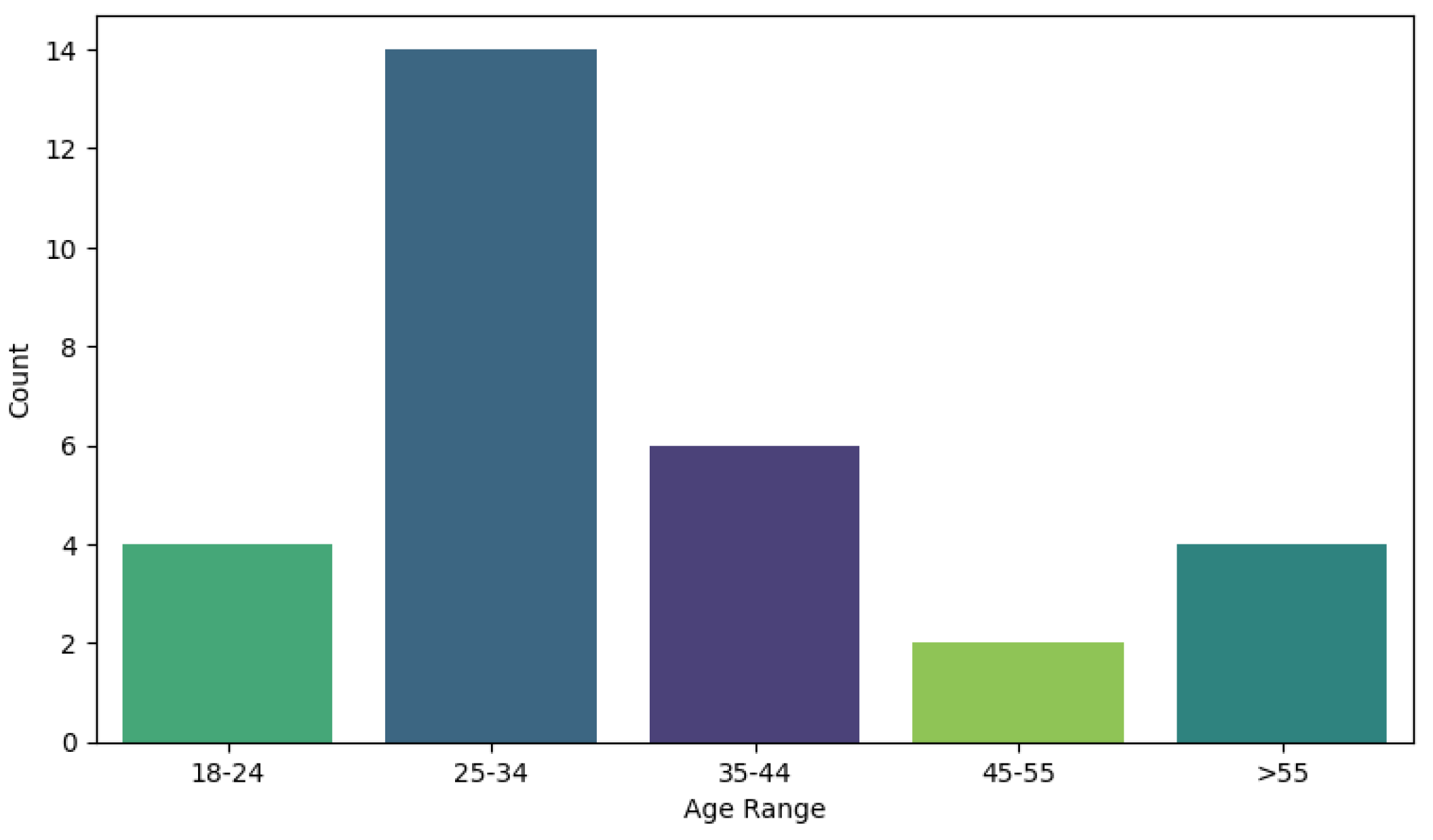
Figure 10 illustrates articipants’ age distribution.
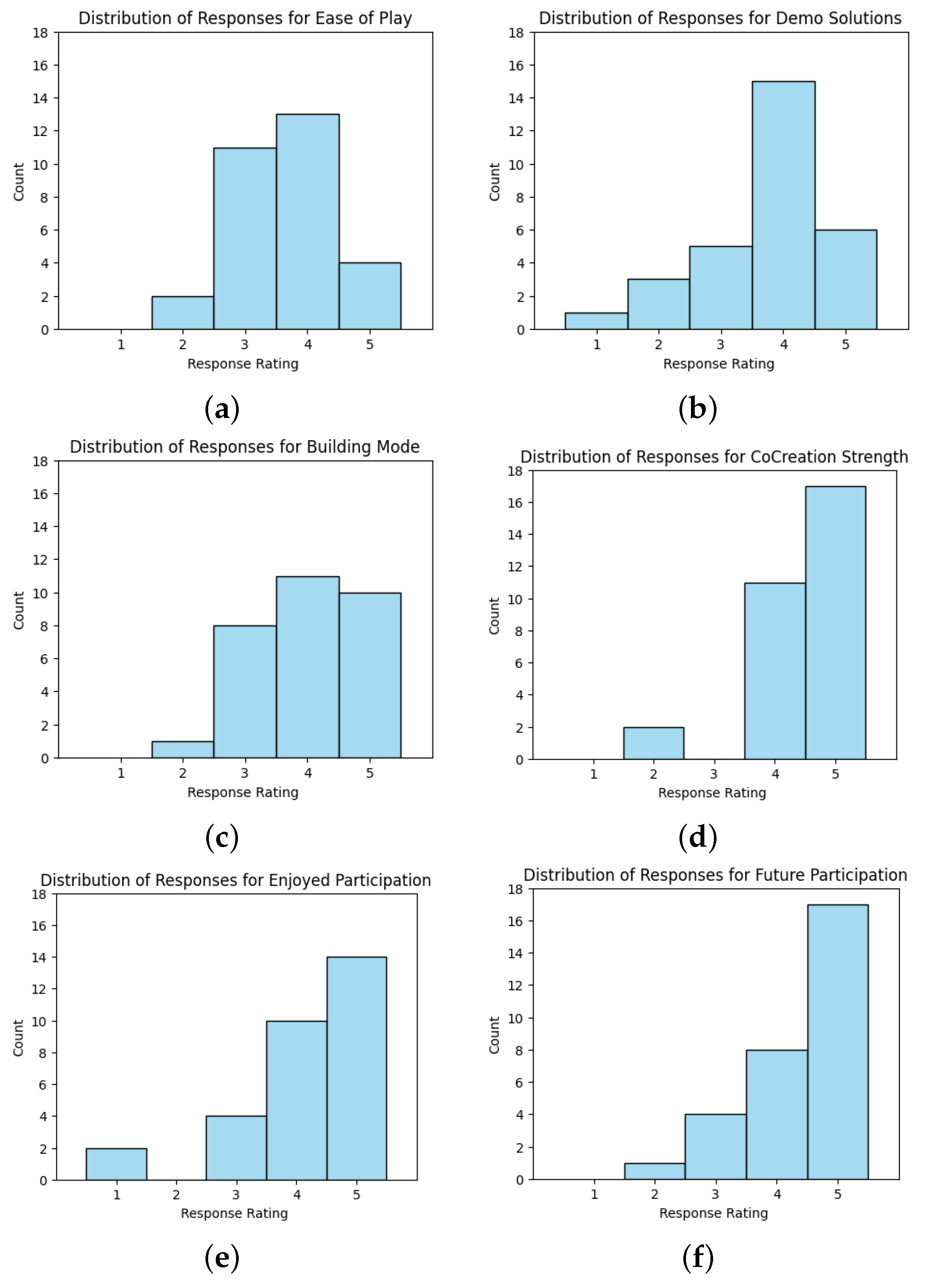
Figure 11 illustrates a summary of participants’ responses to the post-experiment questionnaire. Each question was rated on a Likert scale from 1 (poor/unlikely) to 5 (great/very likely). The majority of responses were concentrated in the 4–5 range, indicating positive perceptions of the game’s design, usability, and potential as a participatory urban planning tool. For example, over 80% of participants rated the game’s ability to facilitate urban design discussions as “very likely” (score of 5). Similarly, the game’s ease of navigation and interactivity were highly praised, with a median score of 4.5. These results highlight the participants’ appreciation of the gamified approach to urban design and the accessibility it offers to both experts and non-experts.
However, some participants raised concerns about the technical aspects of the game. For instance, 10% of respondents assigned lower scores (2 or 3) regarding the realism of environmental feedback provided in the game. This indicates room for improvement in aligning the simulated scenarios with real-world conditions. Overall, the positive skew in the responses confirms the potential of the euPOLIS game to enhance community participation in urban planning.
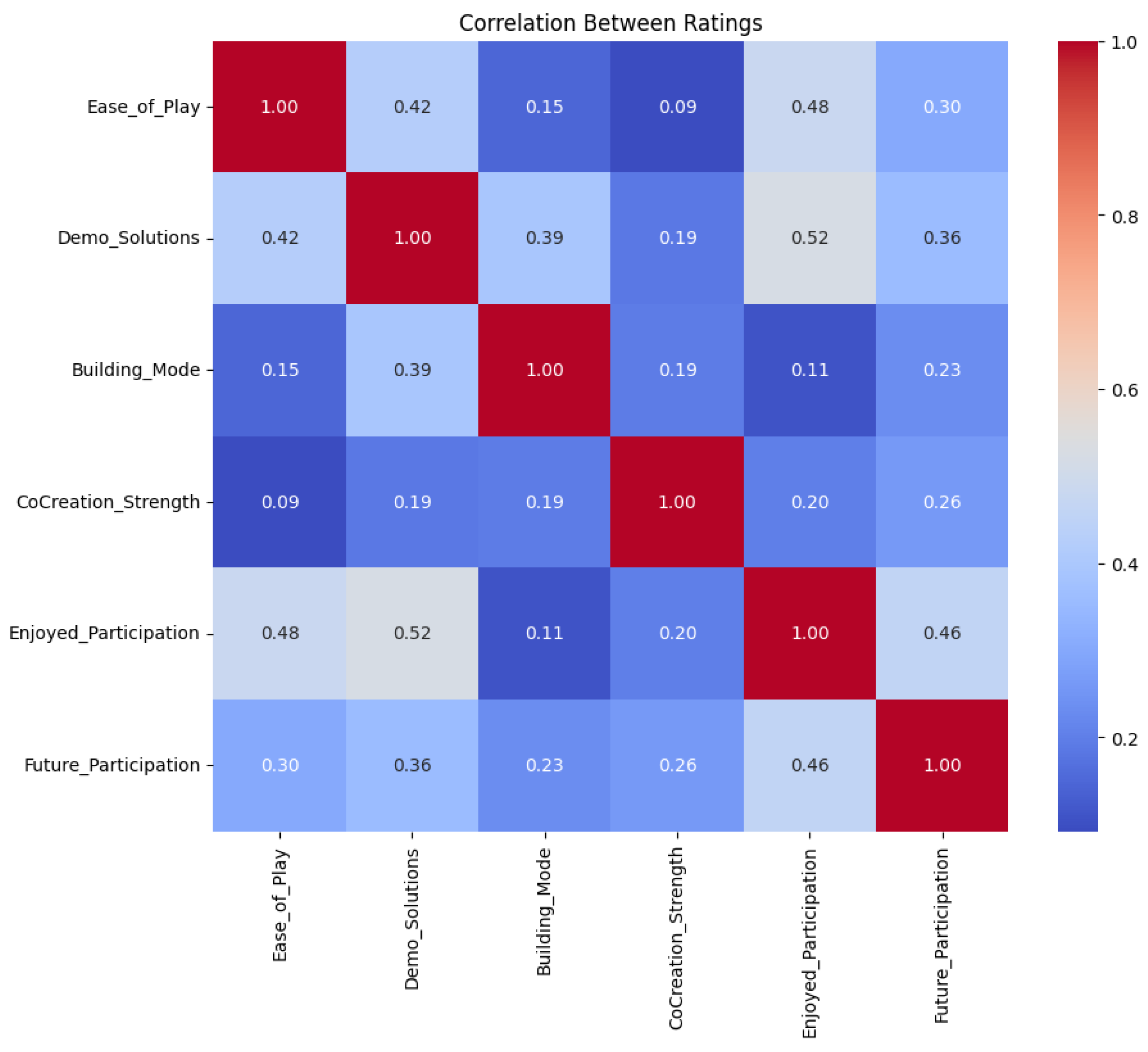
Figure 12 investigates the correlation scores among different questionnaire topics using Pearson’s correlation coefficient. Despite overwhelmingly positive ratings for individual questions, the correlations between some topics remained low. This discrepancy may stem from differences in participants’ priorities or interpretations of the questions. For instance, while most participants appreciated the game’s usability, their views on its educational value or long-term impact varied significantly. This divergence could indicate that participants engaged with the tool from distinct perspectives, with some focusing on its entertainment value and others evaluating its practical utility in real-world urban planning.
These low correlations also suggest that participants may have been influenced by external factors, such as prior familiarity with urban design concepts or personal preferences for interactive media. While the overall feedback was positive, the diverse range of participant opinions underscores the need to further tailor the game to meet varied user expectations. We should clarify that such techniques are often applied in larger datasets. Nonetheless, they can provide value in identifying recurring themes and highlighting common perceptions even in smaller participant groups as well, since they help to capture both trends in general sentiment and key discussion points in a systematic manner.
The word frequency distribution from the open-ended feedback is visualized in
Figure 13, revealing key themes highlighted by the participants. Commonly recurring words included “interactive”, “engaging”, “visualization”, and “collaborative”, reflecting the primary strengths of the euPOLIS game. These terms emphasize the importance of interactivity and collaboration as core elements of the gaming experience.
Interestingly, words such as “complexity” and “learning curve” appeared less frequently, but indicate areas where participants felt challenged. The feedback also included specific suggestions for enhancing the game, such as incorporating more diverse environmental scenarios and improving the interface for novice users. Overall, the word frequency distribution provides qualitative support for the quantitative metrics, illustrating both strengths of the game’s design and areas for further development.
4.3. Urban Regeneration Metrics
The third and final evaluation method of the euPOLIS game involved its ability to provide in-game metrics for intervention planning evaluation. For this purpose, urban planners can view the user comfort parameters that represent the “feeling” of being in that part of the area in the upper left corner of the screen. As an example,
Table 5 presents the user comforts of the solutions proposed by five of the participants in the workshop. To maintain consistency between the solutions in the comparison, the values of the user comforts were all retrieved from the same location. The major observations of this analysis are as follows. First, the temperature decreased in all solutions. By applying similar solutions in a real intervention, a decrease of 0.53 °C is estimated by adding trees to provide shade. Second, the humidity increased by 0.17%rh. (Finally, the air quality improved by increasing the density of O
2 by 0.17% and decreasing the density of CO
2 by 0.18%.
5. Discussion
The euPOLIS game represents a strong step toward decentralizing and democratizing urban planning by empowering citizens to contribute meaningfully to the design process. One of its major strengths lies in its ability to simplify complex urban planning concepts into an accessible and interactive format. Participants appreciated the visualizations and collaborative potential, with many highlighting its capacity to foster engagement in typically underrepresented groups. Another advantage is the game’s dual modes, Feedback and Building, which cater to both evaluative and creative tasks. By leveraging open-source technologies, the game ensures affordability and adaptability for diverse urban contexts.
The integration of Building Information Modeling (BIM) in gaming presents significant opportunities for participatory urban planning by enhancing realism, accuracy, and accessibility in decision-making processes. The euPOLIS game leverages BIM principles by incorporating open GIS data and digital twin models, allowing users to navigate and modify urban environments in an interactive and data-driven manner. Unlike conventional urban planning tools that require specialized expertise, the euPOLIS game provides an intuitive and inclusive platform where both experts and non-experts can visualize, assess, and refine urban interventions. Additionally, using open-source technologies such as Blender-OSM and Unreal Engine 5 ensures cost-effective development while maintaining a balance between accessibility and technical sophistication. By embedding BIM methodologies within a gamified framework, euPOLIS enhances public participation in urban design, fostering a more democratic and transparent planning process.
This study was conducted within the context of a specific research project, where the goal was to test the tool’s reception and usability rather than to apply it directly to ongoing urban interventions. Future research could expand upon this work by integrating the game into real-world planning processes and measuring its impact in those settings. To be more precise, expanding the euPOLIS game to support smart city development would further enhance its role as a collaborative urban design tool. Future improvements could incorporate IoT-based real-time environmental data, AI-driven decision-support systems, and cloud-based multiplayer capabilities to enable more dynamic and data-responsive urban simulations. For example, integrating real-time air quality, traffic, and climate data could allow users to assess the long-term impact of their design choices on sustainability and livability. Additionally, AI-powered urban planning suggestions could guide participants in developing optimized, resilient, and resource-efficient solutions while maintaining flexibility for creative contributions. The introduction of cloud-based collaboration features would also allow for broader engagement across different geographic locations, reinforcing the euPOLIS game as a scalable and adaptive platform for co-creating smart and sustainable urban environments.
During the TNOC festival a random sample of 30 participants provided adequate feedback by filling out the provided questionnaire. Based on their feedback, the euPOLIS game provided a fun and interactive way of participating in urban design procedures, especially in Building Mode, where the users are free to suggest their own solutions. Although the euPOLIS game represents an innovative approach to the promotion of co-design, co-creating and co-participation principles in urban planning procedures, it remains a prototype idea, and several limitations remain at hand.
First of all, compared to the limitations of state-of-the-art approaches, the euPOLIS game has been developed with the idea of asynchronous participation; thus, each participant is free to download the game from online repositories (i.e., the following Google Drive link: [
45]) and easily install it on their machine. This characteristic addresses the issues of in situ workshops without removing the possibility of organizing such events. As an example, this manuscript presents the participation and demonstration of the euPOLIS game at the 2024 TNOC festival.
Furthermore, development of the euPOLIS game utilized open-source software and Open GIS data, minimizing the time and cost of developing the entire game while at the same time providing cross-platform packaging capability if necessary. As a result, the only necessary equipment for playing the euPOLIS game is an internet connection for downloading the game and e-mailing the solution if wanted, along with a computer to install and play the game.
A significant limitation of existing gamified solutions in the literature is that they exclude individuals without digital experience, particularly elderly populations. While this challenge cannot be entirely resolved, the euPOLIS game mitigates this gap by incorporating simple and intuitive game mechanics. The game employs traditional key mappings reminiscent of retro video games from the late 1980s and early 1990s, catering to individuals familiar with that era. For instance, a person aged 30–40 in the 1990s would now be 65–75 years old, representing the target demographic with a higher likelihood of engagement. Although the euPOLIS game does not fully eliminate this challenge, it significantly narrows the gap compared to other approaches.
Several additional limitations of the euPOLIS game were identified during the workshop, primarily related to participant diversity. The workshop involved 30 randomly selected participants with no prerequisite expertise in architecture, landscape, or urban design. This approach aligns with the core objective of the euPOLIS gaame, namely, to decentralize and democratize urban planning processes, particularly during early design stages where diverse brainstorming is essential for guiding experts in developing resilient and sustainable solutions. However, while the game’s environmental simulation was recognized as a valuable feature, some participants noted its lack of precision in terms of mesh fidelity and user comfort estimation compared to real-world conditions. Additionally, the game’s usability faced minor criticism from users unfamiliar with virtual environments. To address this, incorporating a comprehensive onboarding tutorial and simplifying the navigation controls even further could enhance accessibility for less tech-savvy participants.
An additional limitation of the euPOLIS game pertains to the calculation of “User Comforts”. The game employs a linear model to provide a rough estimation of the impact of each object on climate change parameters. This feature aims to deliver real-time feedback to participants, encouraging them to propose realistic and sustainable solutions. However, the “User Comforts” metrics were intentionally simplified to the bare minimum; while functional, this limits their potential. A more advanced approach could involve integrating local climate models derived from national observatories.
Such models were unavailable during the development of the euPOLIS game, making distance-based impact calculations the most feasible option for prototyping. While more sophisticated models could yield more accurate and realistic results, their exploration remains a topic for future research. Furthermore, incorporating additional metrics, such as the cost of proposed solutions, could enhance realism by encouraging participants to consider budgetary constraints. An alternative approach could involve predefining a budget limit and requiring players to design solutions within that range, thereby promoting practicality and feasibility.
In light of the workshop’s limited scale, this case study also highlights the need for broader validation. Future research should expand participant diversity and test the game in varied urban contexts. Enhancements such as improved environmental models, an online multiplayer system, and advanced building tools could further enrich engagement. Integrating climate and socioeconomic impact models along with scenario-based challenges and AI-driven constraints would enhance realism and applicability. These refinements could strengthen the game’s role in fostering inclusive and participatory urban planning.
6. Conclusions
In summary, this work introduces the euPOLIS game as a promising gamified approach to enhance urban design through co-participation, co-design, and co-creation. By leveraging open-source software and open GIS data, the euPOLIS game provides an accessible VR/AR platform that fosters public engagement in urban planning in an interactive and enjoyable manner, effectively bridging the gap between technical experts and the general public. The game empowers players to propose resilient and sustainable solutions for real urban environments. It is freely distributed and can be shared without licensing restrictions.
While the euPOLIS game demonstrates innovation in creating a simple yet comprehensive tool for urban redesign, it currently faces limitations such as low-fidelity models and simplified “User Comforts” metrics. Despite these challenges, its presentation at the TNOC 2024 festival highlighted its potential to inspire citizens to actively participate in urban design processes. The euPOLIS game represents a foundational step toward integrating such technologies into urban development, particularly in decentralizing and democratizing urban planning procedures.
Compared to existing literature, the euPOLIS game innovatively addresses many limitations; however, new challenges have emerged from its current iteration. For instance, adopting high-fidelity models instead of rough open-source approximations could enhance user engagement. In addition, incorporating accurate local climate models would better visualize the real-world impact of proposed solutions, while introducing modes such as budget constraints could help to encourage more realistic and practical designs. These advancements represent the next phase in the euPOLIS game’s evolution.
In conclusion, further research in this field is essential. The integration of digital technologies, particularly VR/AR environments enhanced by AI, can create precise digital replicas of real-world regions, enabling safe and non-disruptive urban planning experimentation. Even if non-expert proposals are not entirely realistic, they can still provide valuable insights during early brainstorming stages. Additionally, such applications hold potential for educational purposes and real-time collaboration through multiplayer features in virtual or hybrid workshops. This case study underscores that gamified technologies have vast potential in urban planning, with their deployment representing a natural progression towards rebuilding cities in a sustainable, resilient, and nature-friendly direction.
