Article

Water Efficiency in the Construction of Water Channels and the Ancestral Constructive Sustainability of Cumbemayo, Peru

by
Doris Esenarro
1,2,
Dayana Palomino Gutierrez
1,
Katherin Santa Cruz Peña
1,
Jesica Vilchez Cairo
1,2,*,
Vicenta Irene Tafur Anzualdo
3,
Maria Veliz Garagatti
4,
Geoffrey Wigberto Salas Delgado
5 and
Crayla Alfaro Aucca
6
1
Faculty of Architecture and Urbanism, Ricardo Palma University (URP), Santiago de Surco, Lima 15039, Peru
2
Research Laboratory for Formative Investigation and Architectural Innovation (LABIFIARQ), Ricardo Palma University (URP), Santiago de Surco, Lima 15039, Peru
3
Institute of Research (ININ), Marcelino Champagnat University (UMCH), Santiago de Surco, Lima 15049, Peru
4
Faculty of Geographical, Environmental and Ecotourism Engineering, Federico Villareal National University UNFV, Cercado de Lima, Lima 15082, Peru
5
Postgraduate University School (EUPG), Federico Villarreal National University (UNFV), Cercado de Lima, Lima 15001, Peru
6
Faculty of Engineering and Architecture, Architecture, Universidad Andina del Cusco (UAC), San Jeronimo, Cusco 08006, Peru
*
Author to whom correspondence should be addressed.
Heritage 2025, 8(9), 345; https://doi.org/10.3390/heritage8090345
Submission received: 27 May 2025 / Revised: 11 August 2025 / Accepted: 20 August 2025 / Published: 24 August 2025
(This article belongs to the Section Biological and Natural Heritage)

Abstract

The ancestral water channels are affected by a lack of awareness regarding their preservation, the deterioration of their structure, and the pollution of nearby water bodies due to waste discharge. Additionally, the growth of vegetation, sediment accumulation, and the presence of crab burrows have caused blockages and erosion of the stone, compromising their stability. Therefore, this research aims to analyze the water efficiency in the construction of water channels and the ancestral constructive sustainability of Cumbemayo, Peru. The methodology is based on an on-site study, taking into account the terrain, climate, and water flow from a spatial, functional, and constructive perspective, supported by digital tools such as Google Earth Pro 2024, AutoCAD 2024, SketchUp 2024, 3D Sun Path 2024, and D5 Render 2024. Regarding the findings, it was evidenced that the channel contains carvings in the rock that reflect their reverence for nature. It also maintains a constant slope of 1.5 mm per linear meter along its 18.9 km length. Its design, which combines straight and zigzag sections, optimizes water flow and may be linked to astronomical and ceremonial knowledge. Its dimensions range between 0.35 and 0.50 m in width and between 0.10 and 0.30 m in depth, with a precise leveling system that allows for flow control. Its stone construction demonstrates the technical mastery of its creators, ensuring strength and long-term durability. In conclusion, this study highlights the importance of the canal and the challenges it faces in terms of conservation. Erosion, vegetation, and sediment accumulation threaten its stability, making it essential to implement protective measures that ensure its long-term preservation.

1. Introduction

Throughout history, ancient civilizations have developed ingenious systems to manage water, adapting them to their needs and geographic conditions. From early irrigation canals to large aqueducts, these infrastructures not only ensured water supply for agriculture, trade, and urban life but also reflected the technical advancements and power of the societies that built them.
Today, in the face of the global water crisis, the study of these systems can offer sustainable solutions for water management and conservation [1]. As an example of this evolution, Figure 1 shows some of the most representative canals and aqueducts in the world.
A notable example is the development of aqueducts in the Roman Empire, such as those in Rome and Segovia, which transported large volumes of water from distant sources using elevated arches and gravity [2]. Beyond their functionality, they symbolized the power of Rome. Similarly, Emperor Trajan promoted the construction of the Fossa Traiana to address the flooding of the Tiber River, connecting it to the sea and reducing overflows [3], as shown in Figure 1A.
In other regions of the world, less monumental hydraulic systems were also essential. In Paquimé, Mexico, a network of dams, ditches, and canals was built to capture rainwater and distribute it throughout the city [4], as illustrated in Figure 1B.
In Babylon, a complex network of canals and reservoirs made it possible to transform desert areas into fertile lands [5], as seen in Figure 1C.
Meanwhile, the Carioca aqueduct in Rio de Janeiro, with its 42 arches, supplied water and became a colonial architectural symbol [6], as shown in Figure 1D.
Figure 1. Hydrological map showing the location of canals and aqueducts around the world. (A) The Rome and Segovia canals in Europe, adapted with permission from ref. [2], 2024, N.G. (B) The Zaragoza canal in Mexico, North America, adapted with permission from ref. [4], 2020, Roo. (C) The Babylon canal in Iraq, Western Asia, adapted with permission from ref. [5], 2024, Ancient Orient. (D) The Carioca aqueduct in Brazil, South America, adapted with permission from ref. [6], 2014, Arcos de Lapa.
Heritage 08 00345 g001
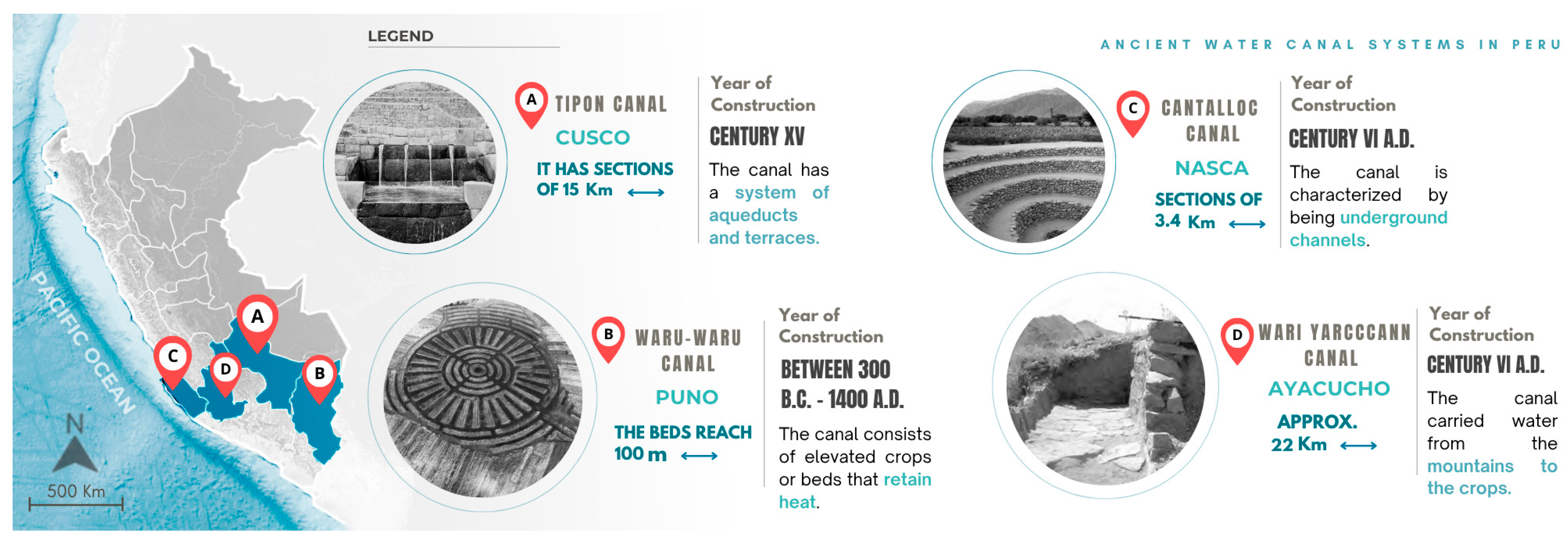
Similarly, Peruvian civilizations developed sophisticated hydraulic systems to ensure water supply and optimize irrigation across diverse geographical environments. Figure 2 presents some of the most representative canals and aqueducts in the country, demonstrating the ingenuity and adaptability of these cultures to their surroundings. The canal system of Tipon is one of the most remarkable examples of hydraulic engineering in ancient Peru, designed to regulate water flow through gravity and land slope. This structure not only ensured irrigation for agricultural terraces but also provided water for human consumption in an environment marked by dry and rainy seasons [7], as shown in Figure 2A.
Continuing with Andean innovations, the Waru system was an ingenious solution that combined raised agricultural beds with water-filled ditches, optimizing irrigation and protecting crops from extreme conditions such as frost and drought [8], as shown in Figure 2B.
On the arid coast, the Cantalloc aqueducts were essential for capturing water from both natural sources and seasonal rains, ensuring a continuous supply for agriculture and the population [9,10], as illustrated in Figure 2C.
Finally, the canals of Wari Yarccann demonstrate advanced knowledge in water management and utilization, as they enabled the development and sustainability of a city in a semi-arid environment for over 300 years [11], as shown in Figure 2D.
Figure 2. Map of Peru showing the location of ancient water canal systems. (A) Tipon, adapted with permission from ref. [7], 2023, Inca Hydraulics. (B) Waru-Waru, adapted with permission from ref. [12], 2022, NANDI PERU. (C) Cantalloc aqueduct Puquio, with permission from ref. [9], 2010, Jaime Deza Rivasplata. (D) Wari Yarccann canal, adapted with permission from ref. [11], 2012, Pérez, I.; Salvatierra.
Heritage 08 00345 g002
Peru stands out for its water diversity, with over a thousand rivers and 107 main watersheds, which are essential for human consumption, agriculture, and industry [13]. Its varied geography—from the Andes to the coast and the rainforest—enabled the development of advanced hydraulic systems since pre-Hispanic times [13]. Figure 3 presents a hydrographic map that shows how these canals and aqueducts capture and distribute water throughout the territory [13].
Various civilizations designed infrastructures adapted to their environment. In Tipon, the Apurimac River (Vilcanota-Urubamba watershed) enabled efficient irrigation in rugged Andean areas, as shown in Figure 3A [12]. On the high plateau, the Waru-Waru system, developed around Lake Titicaca (8372 km2), improved drainage and protected crops from cold temperatures, as seen in Figure 3B [8,14]. On the southern coast, the Cantalloc aqueducts made use of groundwater from the Grande River (275 km), as shown in Figure 3C [9]. In the central highlands, the Wari Yarccann canals, fed by Lake Yanaqocha, extended 30 km and supported agriculture in semi-arid areas, as illustrated in Figure 3D [11].
In northern Peru, the Cajamarca watershed stands out as a hydrological system of vital importance to the region, having played a fundamental role in the development of local communities. Its network of rivers and tributaries not only ensures the supply of water for human consumption but also plays a key role in agriculture by enabling the irrigation of vast cultivated areas in a territory characterized by its climatic diversity [15]. Moreover, its significance extends to industry, as it provides the necessary water resources for various economic activities, including mining and livestock farming—sectors that are essential to the regional economy [15]. Thanks to its capacity to regulate and distribute water, this watershed has been a pillar of environmental sustainability and ecological balance, ensuring the continuity of local ecosystems and the stability of the communities that depend on it [15].
As shown in Figure 4A, the Cajamarca watershed constitutes a fundamental hydrographic network composed of multiple rivers and springs that supply both urban and rural areas. The different sub-watersheds and their connections can also be identified, highlighting the complex distribution of water in the region. This natural structure has been key to the development of agricultural and industrial activities, as well as to the implementation of hydraulic systems throughout history [15].
Within this watershed, one of the most representative systems is the Cumbemayo canals—an example of pre-Hispanic engineering designed for efficient water management. As shown in Figure 4B, the Chonta River and other tributaries are part of this system, allowing water to be transported from high-altitude zones to lower valleys. The image details the path of the Magdalena River and its connections to the Chonta River, highlighting their importance in supplying water to the city of Cajamarca and its surroundings. The Cumbemayo canals, carved into volcanic rock, take advantage of these watercourses to ensure irrigation and human consumption, demonstrating advanced hydraulic knowledge by ancient civilizations [16].
The Cumbemayo canals, located in the Cajamarca region at over 3500 m above sea level, represent an exceptional example of pre-Hispanic engineering. Their name derives from Quechua: “Cumbe” comes from Kumpi, meaning “well-worked” or “stones used as defense,” and “Mayo” comes from Mayu, meaning “river.” This meaning—interpreted as “skillfully channeled river”—highlights the meticulous planning and precision involved in constructing this hydraulic system. Strategically designed to collect, distribute, and regulate water efficiently, this complex enabled the management of water resources in a mountainous landscape with seasonal rainfall, ensuring availability for both irrigation and human consumption [17,18].
Over time, its existence remained in the memory of local inhabitants, but it was not until February 1937 that Ernesto Puente Vélezmoro, administrator of the San Cristóbal estate, rediscovered it among tall grass and carved stone petroglyphs. Months later, in September of the same year, archaeologist Julio C. Tello, during his Expedition to the Marañón, studied its configuration and suggested that it supplied water to Cajamarca through the Agua Tapada system and the reservoirs of Cerro Santa Apolonia [18]. Although its presence had been embedded in local legends—such as those of the Cuismango and the Secses—it had not been scientifically studied or documented until then [18].
One of its most remarkable features was its capacity to regulate water flow, ensuring balanced distribution, even across uneven terrain. Carved into volcanic rock, the canals had curved forms that reduced water velocity, preventing erosion and optimizing irrigation in agricultural areas. Beyond serving as a transportation system, they functioned as an integrated water management strategy, guaranteeing access to water year-round, even during droughts [17].
The knowledge of pre-Hispanic cultures regarding water cycles is reflected in the design of this system, which minimized evaporation and prevented waste or overflow. This not only ensured efficient use of the resource but also prevented soil erosion, contributing to sustainable agriculture in these mountainous regions [19].
Additionally, the Cumbemayo system possesses a symbolic dimension, as water was considered sacred in pre-Hispanic cultures and was associated with fertility deities. This is evidenced by petroglyphs and sculptures found along the canals, suggesting a connection between their practical function and ritual significance. Thus, the Cumbemayo canals represent a fusion of hydraulic engineering and the spiritual worldview of the ancient inhabitants [20].
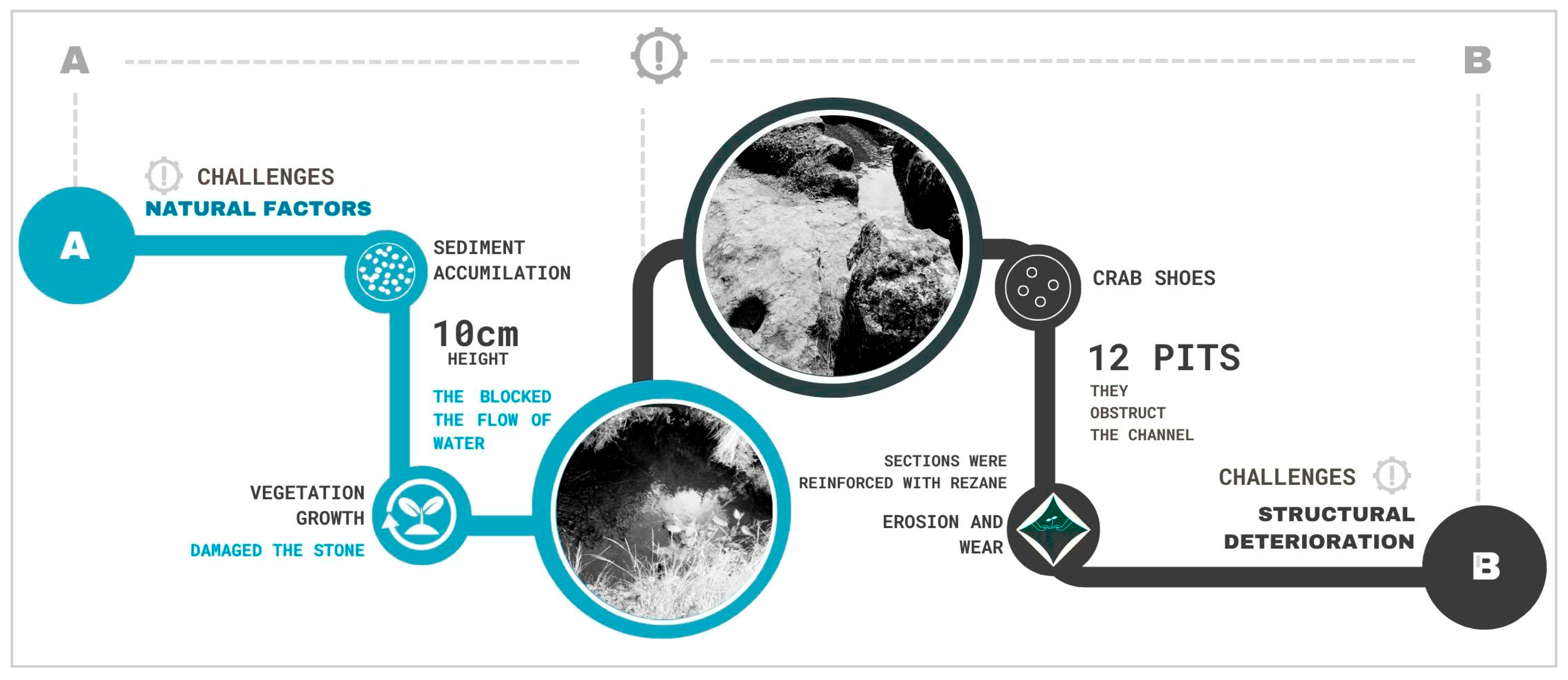
Despite its many benefits, the conservation of the Cumbemayo hydraulic system faces various challenges, stemming from both natural factors and structural deterioration over time. As shown in Figure 5A, the growth of vegetation and the accumulation of sediments up to 10 cm high obstruct the water flow and erode the stone, gradually compromising the structure. Furthermore, Figure 5B shows structural damage caused by the presence of crab burrows, with 12 openings that threaten the canal’s stability. In light of this situation, a comprehensive action plan is required, including regular technical monitoring, scheduled cleanings, and community participation. It is essential to remove invasive vegetation and accumulated sediments to restore water flow and prevent erosion. In sections affected by burrows, it is recommended to stabilize the structure using compatible materials. Additionally, unstable areas should be reinforced with containment elements, and surface drainage should be improved. Finally, local training in conservation and the proper management of tourism will contribute to its sustainable protection.
Erosion and wear have made various interventions necessary, such as restoration work in certain sections, to preserve this invaluable marvel of pre-Hispanic engineering [21].
This leads to the research question: To what extent does the water efficiency in the construction of the canals reflect the ancestral constructive sustainability in Cumbemayo, Peru?
Therefore, the present research aims to analyze the water canals of Cumbemayo in Cajamarca, 2024, from a spatial, functional, and constructive perspective.

2. Materials and Methods

2.1. Methodological Framework

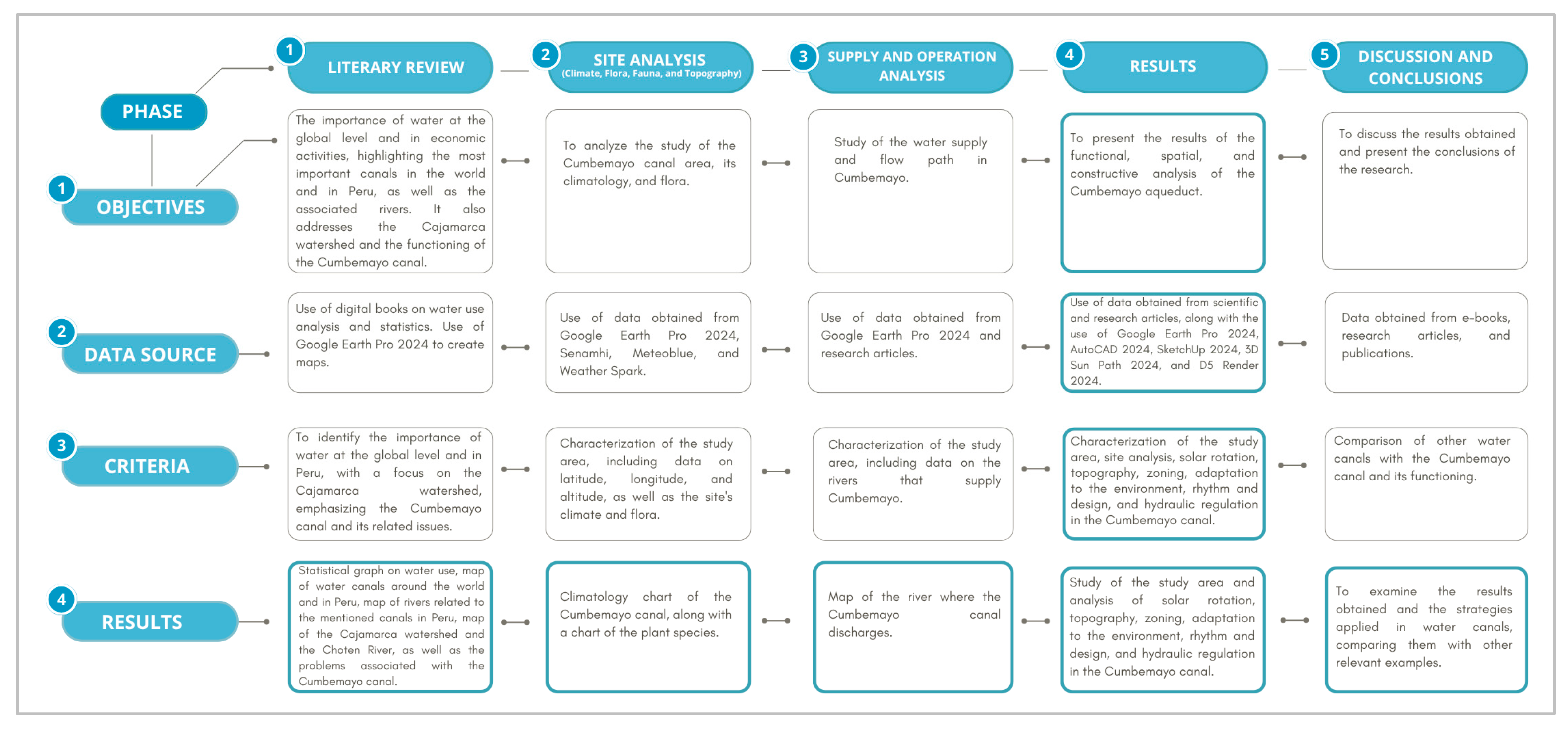
This study was divided into five phases, as shown in Figure 6, ranging from the literature review and site analysis to the evaluation of materials and results. Each phase made it possible to understand the importance of the hydraulic system, its relationship with the environment, and its constructive functionality.

2.2. Methodological Process

2.2.1. Literature Review

In the initial phase of this study, a detailed literature review was conducted to contextualize the spatial, functional, and constructive analysis of the Cumbemayo water canals. This process made it possible to gather key information on water resource management in ancient Andean civilizations, as well as on the cultural and symbolic significance associated with these structures. Various sources were consulted, including research on the Cumbemayo canal network, studies exploring the relationship between pre-Hispanic societies and water, and scientific publications specializing in the preservation of hydraulic heritage.
In addition, an in-depth examination of the presence of petroglyphs in the area was carried out, analyzing their possible meanings, their connection to the natural environment, and the reasons behind their forms. As a result, this review identified the construction techniques used in the canals, the geological and climatic factors that influenced their design, and the way this infrastructure adapts to the Andean landscape. It also allowed for a broader understanding of the interaction between the stone carvings and the hydraulic system, revealing the importance of Cumbemayo not only as a masterpiece of engineering but also as a site rich in symbolism and ancestral knowledge.

2.2.2. Study Analysis, Climatic Analysis, and Flora

The study of the site, carried out using tools such as Google Earth, allows for a more precise identification of the physical, environmental, and climatic conditions of the intervention area [22]. This analysis is essential for understanding the terrain’s limitations and the specific needs of the natural environment in areas like Cumbemayo.
The use of tools such as Google Earth Pro 2024 is essential for obtaining accurate information about the location of the archaeological site and for exploring areas in greater detail. Although certain sections of the canals are covered by the rock forest, Google Earth allowed the visualization of inaccessible points in the terrain, enabling the measurement of distances, areas, and coordinates. This contributed to a more comprehensive understanding of the site and the identification of elements that could not be directly observed.
Additionally, a climatic analysis was conducted to better understand the interaction between the environment and the Cumbemayo canals. Since this pre-Incan hydraulic system is located in a high mountain area with marked seasonal rainfall, its design responds to the need to efficiently capture, channel, and distribute rainwater and surface runoff. The climate has played a crucial role in the preservation of the canals, as factors such as temperature variation, rain-induced erosion, and wind impact have influenced their state of conservation over time [23].
Therefore, essential variables, such as temperature (maximum, minimum, and average), wind speed and direction, relative humidity, and precipitation, were analyzed, as these factors directly impact the functionality and conservation of this pre-Incan engineering work. The process of acquiring these data is described below:
  • Collection of hydrometeorological data from SENAMHI for the Magdalena meteorological station over the past five years (2020–2024), including maximum and minimum temperatures (°C), relative humidity (%), and precipitation (mm). This information made it possible to analyze average climatic conditions and their variations.
  • Additional historical records from Climate-Data for the year 2024 were considered to complement the climatic analysis and obtain a more comprehensive view of the meteorological conditions in Cajamarca.
  • A detailed statistical evaluation of the information obtained was carried out, with the aim of identifying climatic trends that have influenced the design and conservation of the Cumbemayo hydraulic system.
  • A summary climate chart was prepared, including the parameters mentioned in the previous points.
The study of flora in Cumbemayo provides essential information about the ecosystem and its connection to the pre-Incan hydraulic systems. The vegetation reflects soil conditions and water availability. Analyzing this aspect helps to understand how ancient inhabitants used natural resources and adapted their techniques to the environment.
The topography in Cumbemayo demonstrates how the terrain influenced the construction of the canals, enabling efficient water management and allowing the infrastructure to adapt to the natural conditions of the environment.

2.2.3. Analysis of Water Supply and Functioning

The first stage involves locating the study area using cartographic maps of the Cumbemayo canal, taking into account its extension and the surrounding environment. This allows for an understanding of the canal’s point of origin and how it develops along its course. The analysis will focus on its functionality within the geological context, including its relationship with rock formations, the direction it follows, its depth, and the water flow.

2.2.4. Results

Site and Solar Rotation Analysis: This aspect is fundamental as it allows for the evaluation of the relationship between the climate and the intervention area. For this purpose, factors such as geographic location, topography, and surrounding flora are considered. These elements are not only key for architectural planning but also for understanding the local ecosystem and efficiently managing the available resources.
Spatial Analysis: This analysis identifies the presence of natural elements along the canal, allowing for its zoning. Based on this study, the Cumbemayo canal is divided into catchment, distribution, and storage zones. Additionally, to detail its dimensions and characteristics, certain sections of the canal were modeled in SketchUp. In parallel, an adaptation-to-environment analysis was conducted to understand the canal’s flow and the factors contributing to its integration with the landscape. The rhythm and design of the canal are also studied—essential aspects for understanding its forms and the dynamics it maintains in relation to its surroundings.
Functional Analysis: In this phase, a detailed analysis of the symbols engraved in the rock, as well as the drawings that decorate its surface, is carried out. This study is essential as it shows that the canal not only served an agricultural function but also held deep symbolic value. At the same time, the water flow throughout the system and the possible storage sources used are examined. In this way, a comprehensive view is obtained that highlights both the canal’s practical utility and its cultural and spiritual significance within the society that built it.
Constructive Analysis: At this stage, the materials and construction systems of the Cumbemayo canal are studied, considering its division into three sections. This involves analyzing the use of materials such as granite rock, stone, and other local resources. Likewise, the types of soil present and their impact on the hydraulic system’s functioning are examined. This analysis allows for an understanding of how geological conditions influenced the construction and preservation of the canal over time.
As detailed in Figure 7, the modeling process of the Cumbemayo canal includes a thorough analysis of its geographical location and topography, represented through an accurate 3D model. This process also incorporates a study of its solar orientation using advanced digital tools. The main objective of this analysis is to consolidate technical information to determine the supply methods and functioning of the hydraulic system. This process is developed in specific stages to ensure a comprehensive study of the environment and water flow.
In the first stage, as shown in Figure 7A, Equator was used as a tool to obtain the terrain file in Rhino format, along with contour lines that facilitated modeling. In the second stage, according to Figure 7B, Rhinoceros was used to open the file and generate both 3D views and a terrain render, which allowed for a detailed analysis of elevation changes. In the third stage, as seen in Figure 7C, Google Earth Pro 2024 provided precise terrain sections and data, ensuring a more complete study of the profiles. Finally, in the fourth stage, shown in Figure 7D, an analysis of solar radiation impact on the 3D model was conducted using the Development-Andrew’s Blog software, which was key to evaluating the effects of sunlight on the Cumbemayo canal.

2.2.5. Discussions and Conclusions

In the final phase of the study of Cumbemayo, the findings were compared to previous references of other pre-Hispanic hydraulic systems, such as Tipon and Cantalloc. This comparison made it possible to evaluate similarities and differences in the design, functionality, and construction techniques for water management, highlighting the ability of ancient civilizations to adapt their hydraulic infrastructures to diverse geographic and climatic conditions.

2.3. Study Area

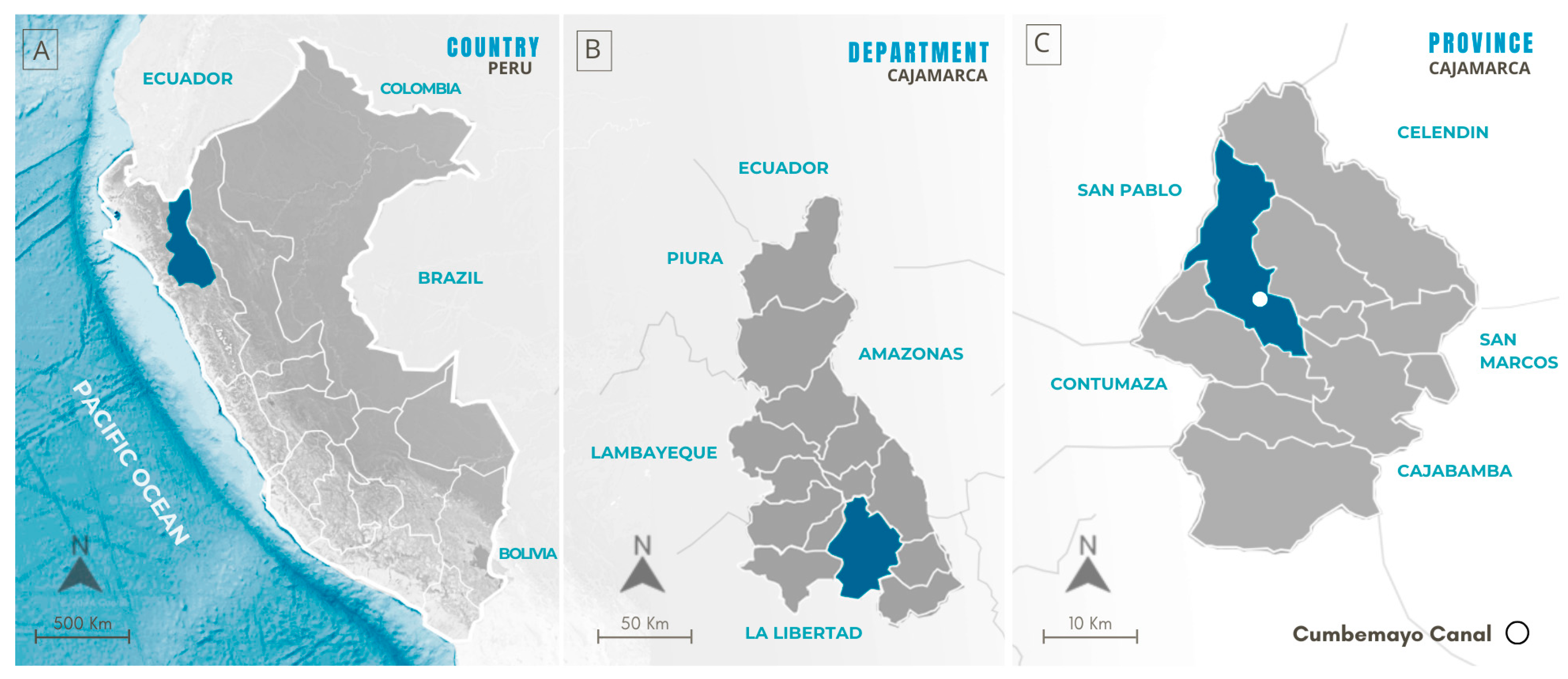
Figure 8 shows the location of the Cumbemayo canal, a remarkable work of hydraulic engineering located in the district, province, and department of Cajamarca, Peru [17]. This ancient system is situated approximately 9 km from the main square of the city of Cajamarca, one of the most important urban centers in northern Peru, renowned for its historical and cultural richness [18]. It is part of the Cajamarca watershed, a key hydrographic network for water supply in the region, and is primarily fed by the Chonta River, one of the most significant tributaries contributing to the distribution of water resources in the area [16].

2.4. Climatic Analysis

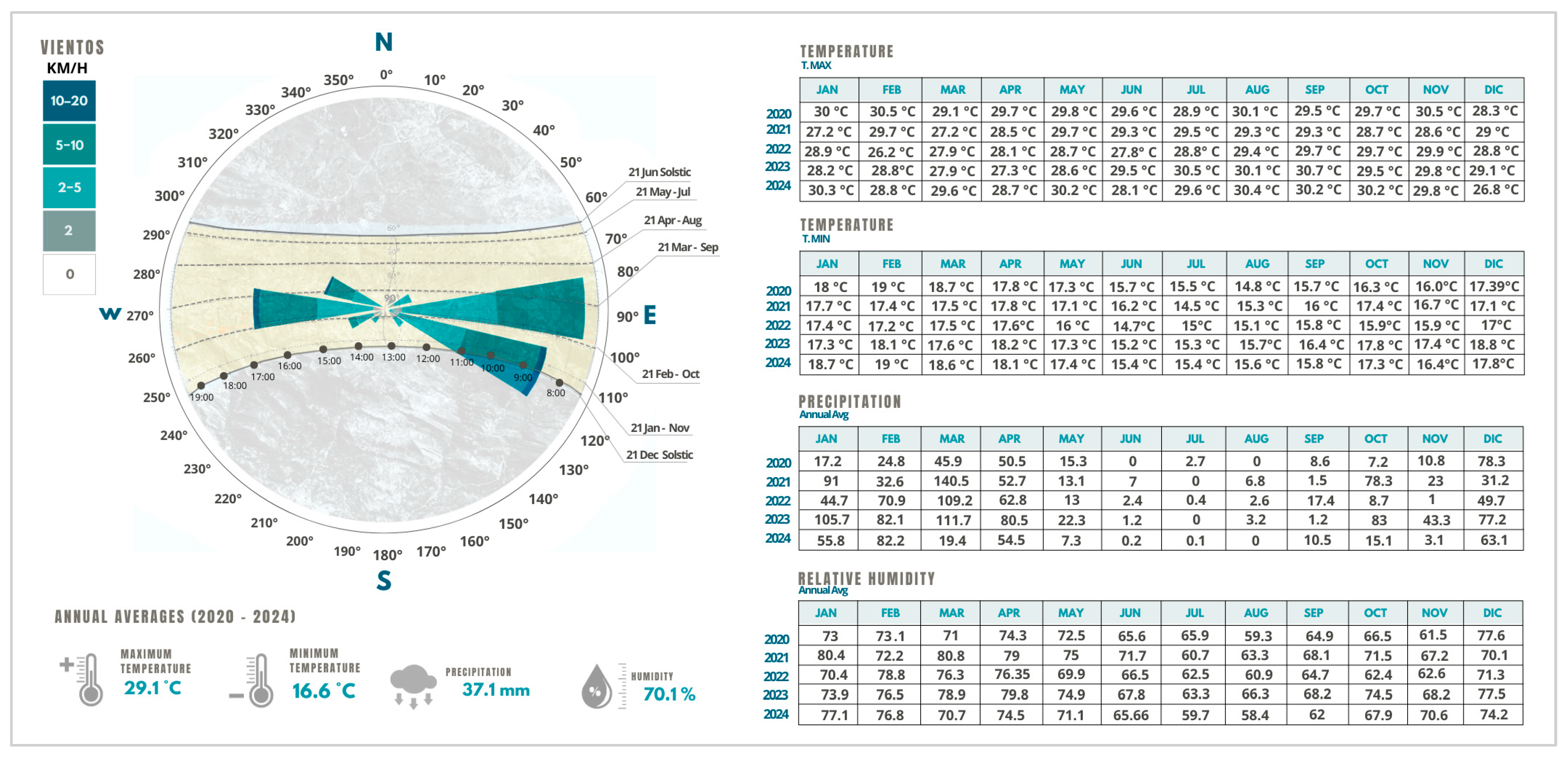
According to the SENAMHI climate classification, the Cajamarca region—specifically in Cumbemayo—has a Cwb climate, which corresponds to a temperate, moderately rainy climate with dry winters and mild summers [24]. The solar diagram, as shown in Figure 9, highlights key points of the sun’s path, such as the solstices and equinoxes, showing the variation in the sun’s trajectory throughout the year. The wind distribution, measured in kilometers per hour, reveals predominant speeds between 2 and 10 km/h, with a main direction towards the east [25]. This analysis helps to understand the incidence of solar radiation and local climatic conditions, essential factors for the efficient design of hydraulic systems and architectural planning in Cumbemayo.
The climate is characterized by average annual maximum temperatures reaching 29.1 °C, while during the coldest months—from June to August—the minimum temperatures can drop to 14.2 °C, e.g., in July 2023. The highest maximum temperature recorded was 30.6 °C in January 2020, and the lowest maximum temperature was 26.8 °C in December 2024. The year 2023 had the highest average maximum temperatures of the five-year period, whereas 2022 recorded some of the lowest minimum temperatures. The highest minimum temperature was 19 °C in February 2020, and the lowest was 14.2 °C in July 2023 [26].
The average annual relative humidity was 70.1%, with monthly values ranging from 55.3% in July 2020 to 80.4% in January 2021, with winter and spring months showing the lowest humidity levels [26].
Regarding precipitation, the annual average was 37.1 mm, with the highest concentration occurring in the early months of the year, especially in March 2022, when a peak of 109.2 mm was recorded. Conversely, rainfall is almost nonexistent from June to August, evidencing a marked seasonality in the hydrological regime [26]. These patterns are consistent with the climate changes reported in Peru over the last two decades, which include increases in temperature and variations in precipitation in the highlands [27].

2.5. Analysis of Flora

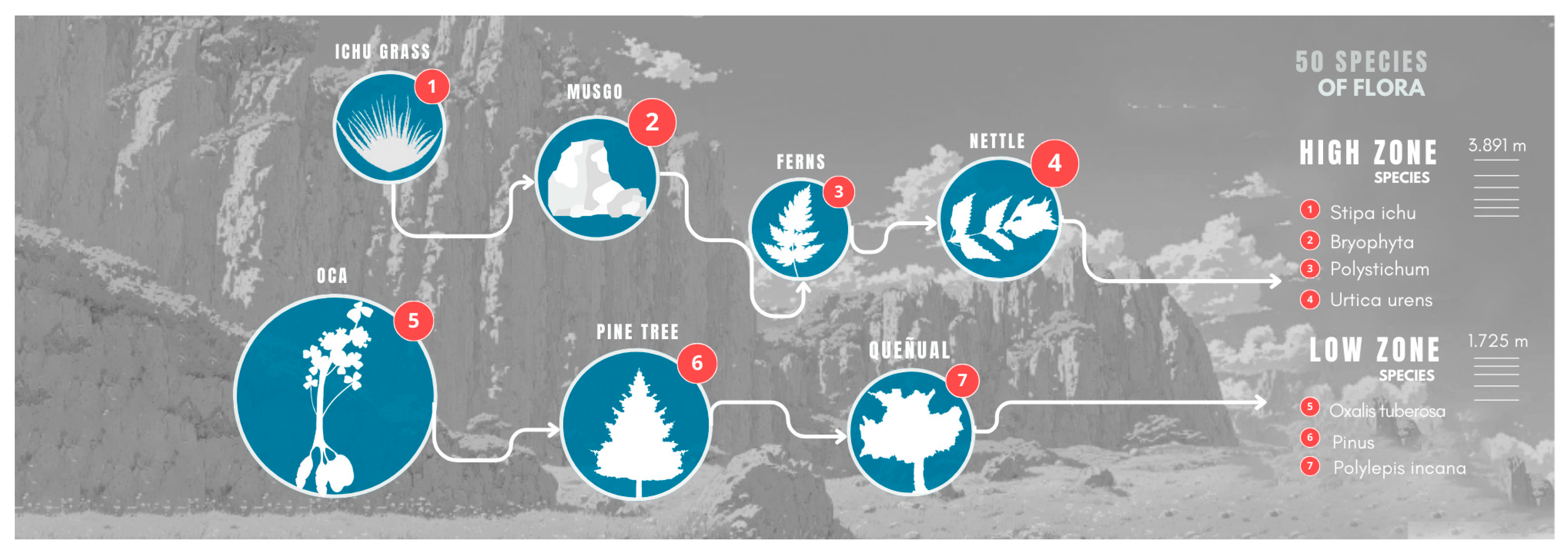
As shown in Figure 10, the flora of Cumbemayo, in Cajamarca, is characterized by remarkable diversity, with approximately 50 species distributed across high and low altitude zones. In the higher-altitude area, notable species include ichu (Stipa ichu), a grass well-adapted to high elevations. Additionally, mosses (Bryophyta) play a crucial role as essential bryophytes for soil moisture retention. Other important species in this region include ferns (Polystichum) and nettle (Urtica urens), a medicinal plant contributing to the area’s biodiversity [28,29].
In the lower zone, the oca (Oxalis tuberosa), an Andean tuber with high nutritional value, stands out. Pine trees (Pinus spp.), which are evergreen species, provide shade and soil stability. Lastly, the quenual (Polylepis incana), a native tree, is notable for its adaptation to cold climates and its distinctive bark. This plant diversity not only enriches the landscape but also plays a fundamental role in ecosystem conservation and hydric regulation in the region [28,29].

2.6. Analysis of Water Supply and Functioning

The Cumbemayo canal is primarily supplied by the Chonta River, which has an approximate length of 85 km, a flow rate of 120 m3/s, and a velocity of 1.5 m/s. Among its tributaries is the Magdalena River, with a length of 70 km, a flow rate of 90 m3/s, and a velocity of 1.3 m/s, as well as various springs originating in the Upper Jequetepeque basin [15,16]. This hydrographic network plays a fundamental role in supplying the pre-Hispanic canal systems, enabling the capture and distribution of water in the Cajamarca region. Through this interconnected system, ancient civilizations optimized the use of water resources for agriculture, human consumption, and other economic activities in the lower valleys.
However, the Chonta River faces contamination problems due to the impact of mining activities along its course, which directly affects the water quality of both the river and its tributaries [16]. This situation poses a risk to the local flora and fauna, as well as to agricultural activities and the water supply for the city of Cajamarca.

3. Results

3.1. Site Analysis and Solar Rotation

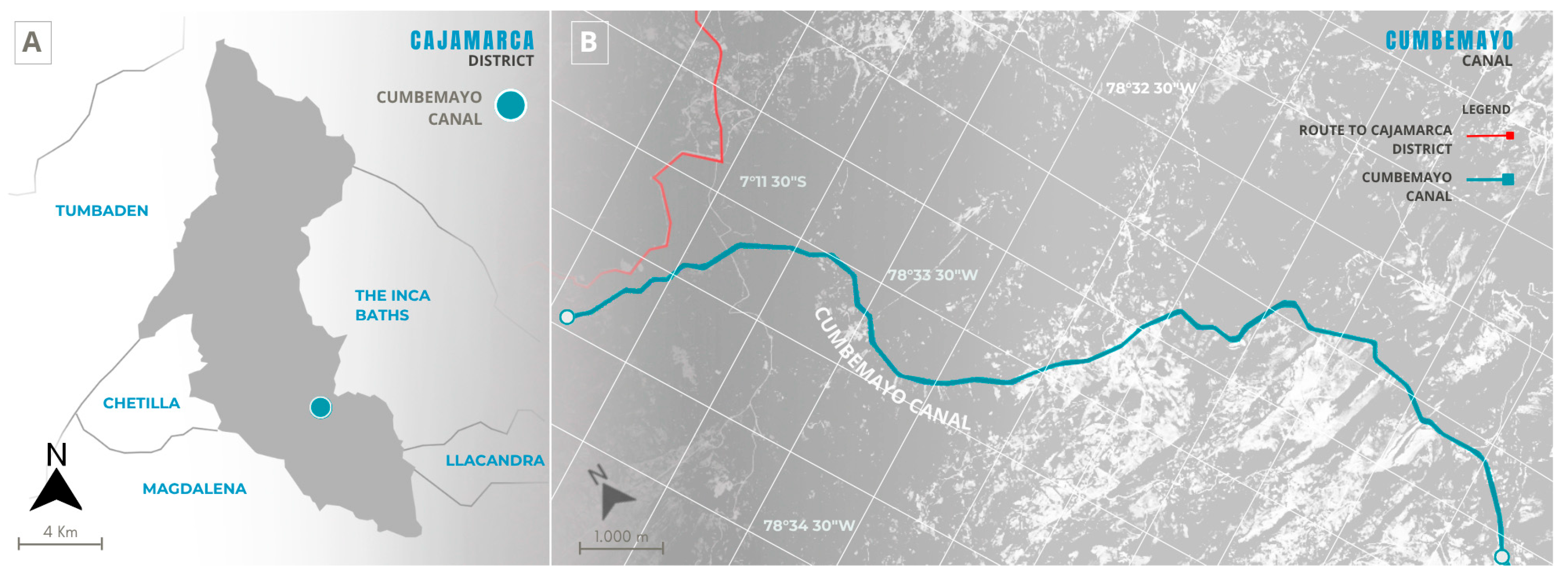
The hydraulic system of Cumbemayo is located in the Cajamarca basin, approximately 7.5 km southwest of the city of Cajamarca, at an altitude of about 3500 m above sea level, with the following coordinates: latitude of −7.1925 and longitude of −78.5375 [30]. This system includes a stone canal approximately 9 km long, designed for water capture and distribution. Figure 11A shows the location of the Cajamarca district and the position of the Cumbemayo canal within the territory, while Figure 11B presents a detailed map of the canal, highlighting its route in relation to the path towards Cajamarca.
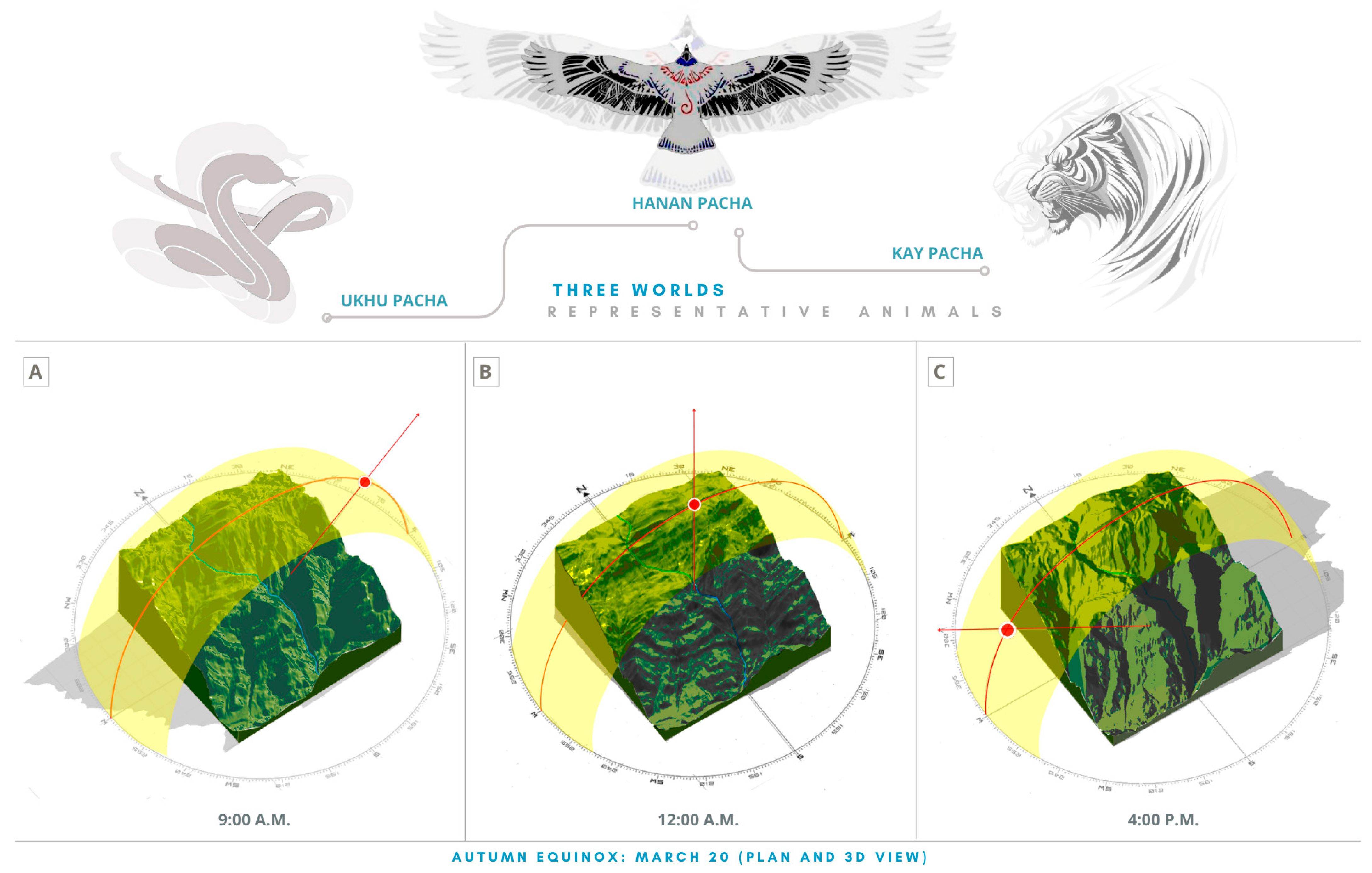
In addition to its hydraulic function, the Cumbemayo canal held symbolic meaning within the Andean worldview, being considered a bridge between the three worlds: Hanan Pacha (the upper world of gods and stars), Kay Pacha (the earthly world of humans), and Ukhu Pacha (the underground world of ancestors and spirits) [18]. The relationship between the canal and astronomical cycles suggests advanced knowledge to predict planting and harvesting periods, linking hydraulic engineering with astronomy [18]. This connection is evident in the solar rotation observed in the canal during the autumn equinox on March 20, when the illumination follows a precise east-to-west pattern, highlighting the integration of Andean hydraulic and astronomical knowledge. As shown in Figure 12, this phenomenon reinforces the bond between the canal’s construction and the Andean conception of the universe.
The coincidence of this phenomenon with the period of greatest precipitation in March seems to emphasize the abundance of water flowing through the canal. As shown in Figure 12A, at 9:00 a.m., the sun’s rays incline from the east, casting elongated shadows over the rock formations from north to south, symbolizing the connection between Hanan Pacha (the upper world) and Kay Pacha (the earthly world), where the light descends as a manifestation of the gods to fertilize the land. As illustrated in Figure 12B, at 12:00 p.m., the sun reaches its highest point at the zenith, illuminating the surface directly and evenly, representing the perfect balance among the three worlds and the blessing of Inti (the Sun god), ensuring the fertility of the fields and the abundance of water channeled from Ukhu Pacha (the underworld). Finally, as shown in Figure 12C, at 4:00 p.m., the light comes from the west, taking an opposite inclination and casting shadows from south to north, marking the end of the day and the transition of the light toward Ukhu Pacha, ensuring the return of water to the depths to renew the cycle.
This distribution of light demonstrates a profound knowledge of astronomy and the symbolic integration of the sun and the three worlds into pre-Hispanic constructions, highlighting the relationship between solar phenomena and the water cycles that sustained the canal.

3.2. Spatial Analysis

3.2.1. Topographic Analysis

The Cumbemayo region is characterized by mountainous terrain with steep slopes, which allows water to flow naturally by gravity, facilitating its movement toward lower areas and optimizing its use [31].
This terrain consists of volcanic rock formations, whose hardness has been utilized to guide the water’s course in a controlled manner, reducing erosion effects and ensuring the canal’s stability over time [31].
Additionally, the area is located within a stone forest sculpted by millennia of erosive processes, where a hydraulic engineering work over 3000 years old can be found [32]. These formations, known as “Los Frailones” or “The Rock Monks,” not only influence the direction of the canal but also act as natural barriers that regulate the water flow [31]. Regarding altitude, Cumbemayo is located at approximately 3500 m above sea level, with variations ranging from 1250 m in the lowest areas to 3647 m at the highest points. This altitudinal difference plays a fundamental role in water conveyance, allowing it to move without the need for mechanical intervention.
As for the canal’s construction, it can be divided into two sections. The first, approximately 850 m in length, has been carved directly into volcanic rock, incorporating volumetric forms and petroglyphs on its surface [20]. The second section extends for 8220 m, adapting to the terrain through excavations in the soil, ensuring its functional continuity and the efficient conveyance of water to its final destination [20].
In relation to the slope of the terrain, as shown in Figure 13, the topographic cross-sections A-A, B-B, and C-C present significant variations: cross-section A-A has a maximum slope of 25.5% and an average slope ranging between 12.9% and 12.1%, with moderate inclines that allow controlled water flow; cross-section B-B, with maximum slopes ranging between 49.3% and −56.2%, reveals areas with steeper gradients and abrupt elevation changes, with an average slope between 26.3% and −30.1%, suggesting faster and more turbulent flow in certain sections; while cross-section C-C shows maximum slopes of 11.6% and −65.9%, with an average slope between 4.0% and −24.8%, indicating transitional zones between gentle and steep slopes.
These topographic variations not only influence the path of the water but also determine the distribution of Andean grasslands and the strategic placement of crops. The combination of these elements creates a unique and dynamic landscape, where the natural architecture of the rocks and the ancestral engineering of the canals come together to ensure the availability and efficient use of water resources.

3.2.2. Zoning and Dimension

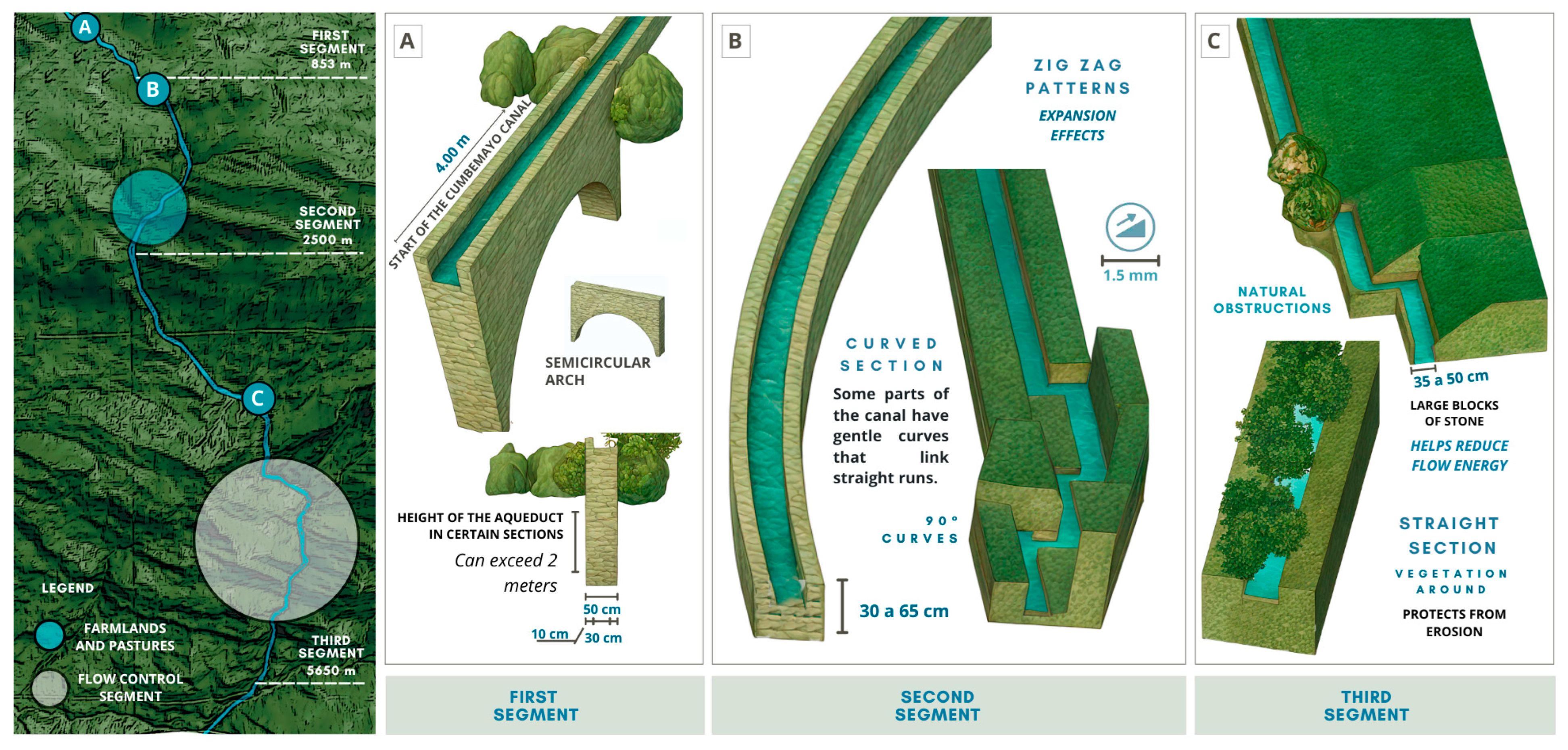
The entire canal spans 9 km and is divided into three sections with distinct characteristics [33]. The first section, 853 m in length, consists of a straight and continuous segment, carved entirely into the rock with mathematical precision, demonstrating the advanced hydraulic knowledge of its builders. Its constant slope of 1.5 mm per linear meter ensures a stable water flow without the need for additional regulation structures [17]. In this section, the depth varies between 10 and 30 cm in the surface areas, which corresponds to the gentle slope and the need to maintain a constant flow without generating turbulence or excessive losses due to infiltration.
Being at the initial part of the route, where the water flow is lower, this depth is sufficient to ensure efficient water conveyance without an uncontrolled increase in velocity [33]. This initial segment represents one of the best-preserved sections of the canal, evidencing the detailed planning behind its construction, as shown in Figure 14A.
The second section, extending 2500 m, incorporates design modifications to adapt to the slope of the terrain. In this section, the zigzag pattern plays a fundamental role in slowing down the water and distributing its flow evenly [17]. The depth varies between 20 cm and 1 m in elevated areas, in response to the need to control the increase in water velocity due to the steeper incline. The greater depth in these areas helps dissipate the flow’s energy, preventing the water from eroding the canal walls. Additionally, the curves, ranging from 30 to 45 cm in width, and the elevated canals, rising over 2 m in height, help redirect the water toward agricultural and grazing areas, minimizing resource loss and optimizing its use. The combination of these elements ensures a uniform distribution of water without causing overflows or accelerated erosion along the edges of the canal [17]. This section clearly demonstrates the canal’s adaptation to the topography, as shown in Figure 14B.
The third section, measuring 5650 m, is characterized by sharper angles and curves designed to stabilize the water flow. As the canal descends into lower areas, natural storage and filtration structures help temporarily retain the resource, reducing flow velocity and preventing erosion [34]. In this section, the width and depth of the canal range between 0.3 and 0.6 m, depending on the terrain slope and the volume of water being transported. The increased depth in certain areas is necessary to prevent overflows and ensure efficient storage prior to final distribution. Since this area is more exposed to evaporation and infiltration due to the looser soil texture, the design of this section seeks to minimize these losses, ensuring that a sufficient amount of water reaches the agricultural fields [17]. The planning and flow control in this final section can be observed in Figure 14C.

3.2.3. Adaptation to the Environment

The canals of Cumbemayo demonstrate exceptional adaptation to the natural environment, taking advantage of the topography to ensure efficient water flow without drastically altering the landscape. In Figure 15A, the canal follows the edge of the terrain, running along the side of the path while maintaining a defined trajectory that optimizes its integration with the surroundings. Then, in Figure 15B, the canal adheres to the mountainside, avoiding abrupt changes in its course and ensuring terrain stability without causing erosion. Finally, in Figure 15C, the canal runs beneath large rock formations, a recurring strategy along its route, either bypassing obstacles or passing underneath them. This planning reveals an advanced understanding of the terrain and precise engineering, enabling efficient water distribution without modifying the area’s geography, ensuring its availability for various uses and preserving harmony with the landscape [18]. Likewise, the system also adapts to the cultural landscape, as it is accompanied by ceremonial altars carved into rock, a rock sanctuary with a human shape, and petroglyphs linked to ritual practices. The canal coexists with traditional paths used by local inhabitants, agricultural areas with Andean crops, and small structures related to community life. These elements reveal a physical as well as a symbolic and social integration of the hydraulic system into the territory [18].

3.2.4. Rhythm and Design

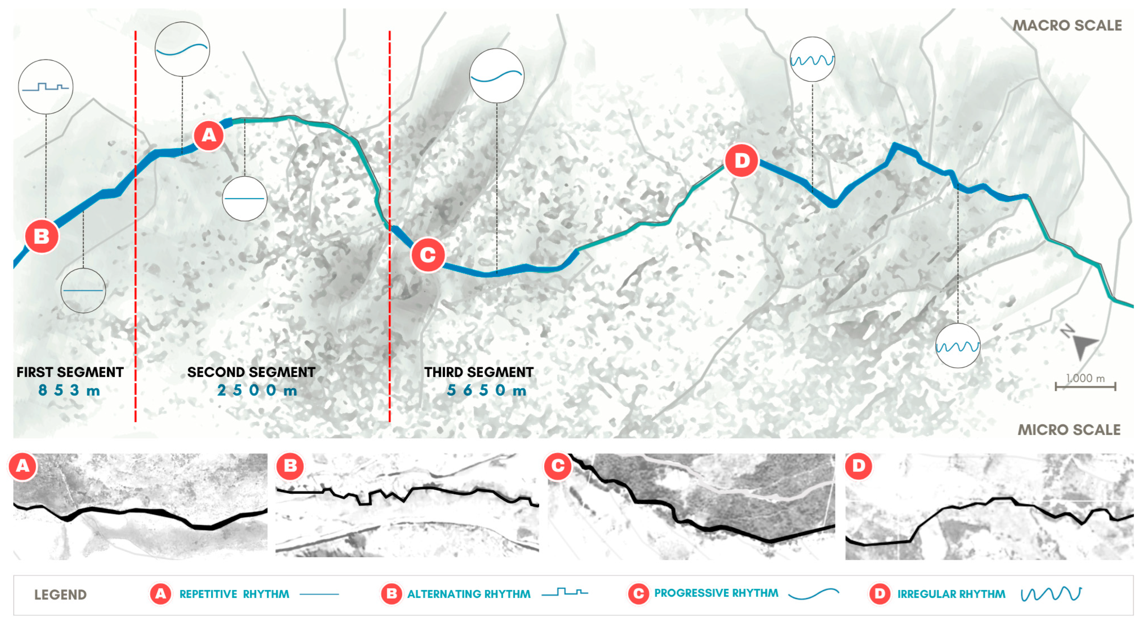
The Cumbemayo canal exhibits four types of architectural rhythm, in accordance with the principles described by Ching in Architecture: Form, Space, and Order, which highlights a combination of functionality and adaptation to the environment [35].
First, repetitive rhythm is observed in the straight sections of the canal, where the shape and width remain constant, creating a sense of continuity and order, as shown in Figure 16A. In these segments, the slope is minimal, ranging from 1.5 mm/m to 3 mm/m, which allows a uniform flow with an approximate velocity of 0.4 m/s. Thanks to this configuration, the water flows steadily, without generating turbulence or excessive erosion. Additionally, the low incline maintains a moderate and constant discharge, avoiding sudden fluctuations in the water flow [17,35].
On the other hand, alternating rhythm is manifested in the zigzag sections, where directional variations help control the water’s speed and reduce erosion, as seen in Figure 16B. In these areas, the slope increases up to 2 cm/m, accelerating the flow to 0.8 m/s. To counteract this effect, the canal depth varies between 20 cm and 1 m, dissipating the water’s energy and ensuring a stable flow. Moreover, the width fluctuates between 30 and 45 cm, especially in the sections where water must be redistributed to crops and pasturelands, optimizing its use without causing overflows. This rhythm ensures efficient flow distribution, avoiding excessive accumulation at a single point and guaranteeing an even distribution of the resource [17,35].
Progressive rhythm is observed in the canal’s gradual descent from the continental divide, with subtle slope changes that regulate the flow and balance the water distribution, as illustrated in Figure 16C. In this section, the slope can reach up to 3 cm/m, increasing the flow velocity to 1.2 m/s. To mitigate the effects of this acceleration, the depth and width of the canal vary between 0.3 and 0.6 m, minimizing evaporation and allowing for efficient storage before the final distribution. This design is essential for maintaining flow stability, preventing stagnation or significant losses along the route [17,35].
Finally, irregular rhythm appears in segments where the canal’s geometry abruptly adapts to the topography, altering its width and depth without a fixed pattern, as shown in Figure 16D. These variations respond to the terrain’s conditions, requiring structural modifications to prevent water loss, maintain stability, and optimize functionality. In these sections, the flow velocity is variable, depending on changes in slope and canal shape, with values ranging from 0.5 to 1.1 m/s. Additionally, the irregularity of the design influences flow distribution, allowing water to temporarily accumulate at certain points before continuing its course, which facilitates a natural regulation of the discharge according to the system’s needs [17,35].
From a geometric perspective, the Cumbemayo canal can be described as an articulated linear form, combining straight lines with strategically placed curves to guide the water efficiently. This design follows Ching’s concept of regulating lines, where the geometry of the canal serves not only a technical function but also an aesthetic and symbolic one. In this way, hydraulic engineering is harmoniously integrated with the natural environment, reflecting the advanced knowledge of the civilization that built it [17,35].

3.3. Functional Analysis

3.3.1. Hydraulic Design and Flow Regulation in the Cumbemayo Canal

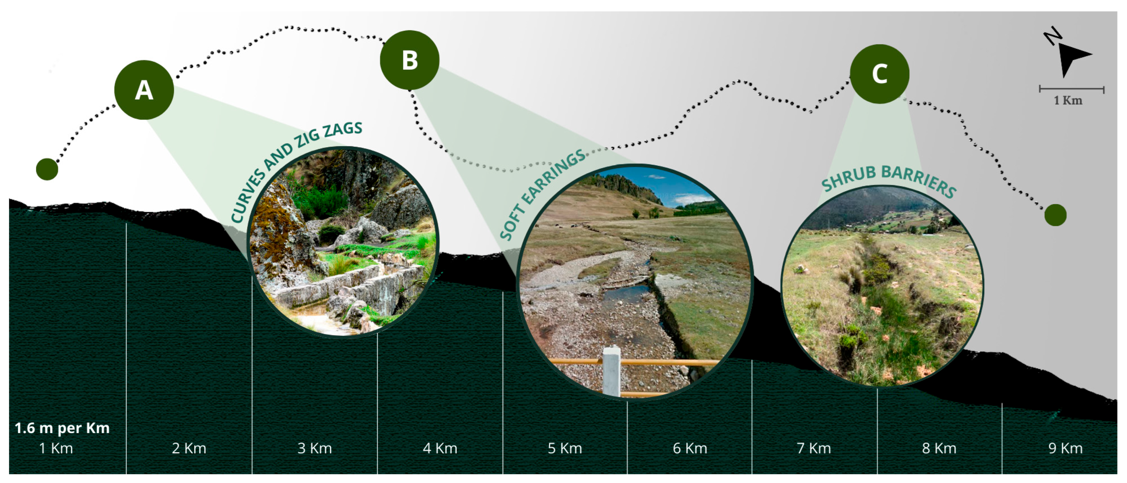
The Cumbemayo canal is a pre-Incan hydraulic engineering work that demonstrates a deep understanding of water flow regulation along its approximately 9 km route. Its design allows for the control of both the speed and volume of the water, preventing erosion and ensuring efficient use. The controlled slope, which ranges between 1.6 m/km and up to 7 mm/m, maintains a stable flow velocity of approximately 0.29 m/s, resulting in a uniform subcritical flow and minimizing turbulence that could affect the canal’s structure [17]. To achieve this hydraulic balance, various flow regulation strategies were implemented along its course.
The section of the canal where curves and zigzags are found forces the water to constantly change direction, dissipating its kinetic energy and reducing its speed. This configuration not only prevents accelerated erosion of the canal walls but also allows for more precise flow control. Additionally, this technique helps to distribute the flow evenly, avoiding water accumulation in a single area and ensuring efficient conveyance to the following sections of the system [17], as shown in Figure 17A.
Complementarily, the gentle slopes have been designed to maintain a stable flow velocity, as their moderate inclination prevents abrupt variations in discharge, favoring continuous water transport without the risk of overflows or excessive accumulation. Thanks to this characteristic, the canal ensures efficient conveyance of the water resource without generating turbulence that could compromise its structure. Furthermore, the planning of these slopes demonstrates advanced knowledge in flow management and terrain adaptation [17], as observed in Figure 17B.
On the other hand, shrub barriers play a key role in protecting the surrounding land from erosion and stabilizing the canal structure. These barriers reduce sediment accumulation in the canal bed, preventing blockages that could interfere with the water flow. Their presence reflects a sophisticated approach to environmental management, ensuring the preservation of the canal and the long-term sustainability of the hydraulic system [17], as shown in Figure 17C.
Taken together, each of these design strategies demonstrates the advanced hydraulic knowledge applied in Cumbemayo, integrating the canal harmoniously with its natural environment and optimizing its functionality to guarantee a stable and efficient water flow [17].

3.3.2. Symbolism

The canals not only fulfilled a hydraulic function but also held deep symbolic value within the Andean worldview, representing the spiritual connection between people, nature, and deities [18]. Elements such as petroglyphs and labyrinths reflect beliefs, rituals, and sacred relationships, turning architectural design into a medium for conveying spiritual meanings.
As shown in Figure 18A, the Andean crosses symbolize harmony and natural cycles, while the radiant star may represent Venus, associated with fertility and astronomical references, as shown in Figure 18B. Additionally, the stone with hieratic figures depicting faces and serpents suggests symbolic practices, as observed in Figure 18C, and finally, the solitary block with carved sandals may have been used in unknown ceremonies, as shown in Figure 18D. These elements highlight how architecture and rock art converge in a symbolic expression that integrates functionality into the sacred element [17].

3.4. Constructive Systems and Materials Analysis

The Cumbemayo canal is an advanced hydraulic engineering work with a strong ritual component, built by a pre-Incan civilization, possibly an ancestor of the Cajamarca culture. According to tradition, the Cuismango were the first inhabitants of the region and experts in water management, organizing their work in teams, where some carved the rock, while others directed the water flow, and some supervised the canal’s alignment to ensure its proper functioning [18].
Additionally, the legend mentions the Secses, outsiders who altered the course of the water, affecting agriculture and local supply. Although there is no archaeological evidence of their existence, it is believed that they may have been a rival group whose presence motivated the Cuismango to improve the capture and distribution of water resources [18].
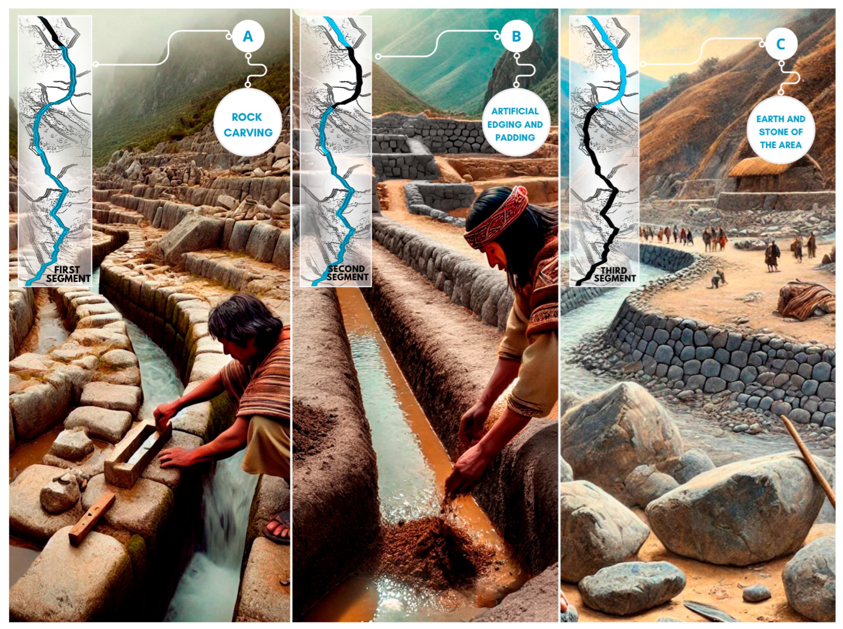
The canal was built in three sections using different techniques and materials. As shown in Figure 19A, the first section, 853 m in length, was entirely carved into granite rock using simple tools such as ropes and compasses, achieving precise shapes with 90° angles [17]. Then, as shown in Figure 19B, the second section, measuring 2500 m, combined rock carving with the construction of artificial edges made from local stones and fill material. To adapt to the terrain’s slope and extend its reach, the edges were reinforced with retaining walls [17]. Finally, as shown in Figure 19C, the third section, 5650 m long, was built as an open-air channel using earth and stones from the area. In this section, priority was given to its use for agricultural irrigation, incorporating a slight additional slope to ensure continuous flow [17].

4. Discussion

Ancestral hydraulic systems have been essential for ensuring water supply in various regions, serving both human consumption and agriculture. These infrastructures stand out for their ability to efficiently manage water resources, including their collection, storage, and distribution. Moreover, their design ensured equitable access within the community, allowing for the sustainable use of water over time.
From a spatial perspective, the canals of Tipon, Cumbemayo, and Cantalloc exhibit significant differences in their layout and adaptation to the environment. In terms of zoning and dimensions, Tipon is composed of stepped terraces interconnected by water channels, with a total length of 1.2 km, allowing for efficient irrigation on steep slopes [35]. In contrast, Cumbemayo has a length of 853 m, designed to follow the natural terrain and optimize water flow [17]. Meanwhile, Cantalloc is structured through a system of filtration galleries and underground tunnels covering 371.8 m, ensuring water capture in an arid zone [23].
Regarding adaptation to the environment, Tipon uses gravity to distribute water through its agricultural terraces, preventing erosion and maximizing its use with an average slope of 2 cm per linear meter [36]. Cumbemayo channels water over a rocky surface with a constant slope of 1.5 mm/m, allowing for water transport without the need for large additional structures [17]. Cantalloc, due to its location in a desert zone, employs a natural filtration system with a slope of 1.8 mm/m, facilitating the capture of groundwater and its efficient storage [23].
Rhythm and design also vary among the systems: Tipon follows an orderly and symmetrical layout of terraces and channels, with terrace heights ranging from 0.5 to 1.2 m [34]. Cumbemayo features a curving layout with straight and zigzag sections, with canal depths between 0.35 and 0.50 m and widths of 0.10 to 0.30 m [18]. Meanwhile, Cantalloc uses a spiral pattern in its galleries, with diameters ranging from 1.5 to 3 m, optimizing water capture and structural stability [23].
From a functional analysis perspective, these systems not only performed the task of water distribution but also featured hydraulic designs tailored to their specific needs. For flow regulation, Tipon used a series of waterfalls and channels with a slope of 2 mm/m, enabling equitable distribution of water across different terrace levels without causing erosion [35]. In Cumbemayo, the 1.5 mm/m slope allowed for continuous flow without the need for additional mechanisms to control water speed [17]. In Cantalloc, water was regulated through underground galleries with vertical access points every 20 to 30 m, allowing for gradual and controlled water capture [23].
From a symbolic and cultural perspective, Tipon had a strong ceremonial component associated with the fertility of the land and the worship of water as a sacred element, with stepped fountains up to 2 m high symbolizing the purity of water [36]. In Cumbemayo, the presence of petroglyphs along the canal suggests a connection with religious rituals related to the water cycle and its importance in the pre-Incan worldview; these petroglyphs are distributed every 50 to 100 m [17]. In contrast, Cantalloc had a more survival-oriented focus, with a functional structure and no clear evidence of ritual use, but with a system designed to facilitate periodic maintenance and cleaning every 3 to 5 years [23].
From a constructive analysis perspective, each system used different materials and techniques adapted to its environment. Regarding the construction system and materials, Tipon used precisely fitted stone walls, with average blocks measuring 0.5 × 0.4 m, which prevented erosion and facilitated water channeling [36]. Cumbemayo stands out for its canal carved into volcanic rock, with a geometric design that optimizes water conveyance with minimal losses and canal walls 0.30 m thick, enhancing its durability [17]. Cantalloc, in turn, used underground galleries with spiral openings designed to facilitate aquifer recharge and efficient water access, with reinforced stone walls and tunnels with diameters ranging from 1.5 to 3 m [23].
The comparative analysis shows that despite their differences, Tipon, Cumbemayo, and Cantalloc share the use of local materials and environment-specific solutions. Cumbemayo stands out for its precision rock carving linked to religious practices [17]; Tipon combines carved stone with agricultural and ceremonial design [36]; and Cantalloc employs spiral structures and underground channels that ensure durability and continuous water flow [23].

5. Conclusions

The Cumbemayo hydraulic system not only represents a milestone in pre-Hispanic engineering but is also essential for understanding its maintenance and functionality. The connection between its canals and the meticulous regulation of water flow prevents erosion and waste, ensuring an efficient supply and reducing the risk of sedimentation or contamination. However, the influence of external factors, such as human activity and environmental degradation, poses a challenge to the preservation of the system and water quality in the region, making the implementation of conservation and restoration strategies essential.
The analysis of the canal’s spatial distribution, functionality, and construction techniques highlights the builders’ ability to integrate the structure with the natural environment. Its layout respects the area’s topography, adapting to irregularities in the terrain without significantly altering it. This allowed for the optimization of water flow while maintaining a balance between efficiency and ecosystem preservation. From a functional perspective, the system not only facilitated water supply but also formed part of a sustainable infrastructure that ensured its rational use across various activities [17,18].
Beyond its practical utility, the Cumbemayo canal is also a manifestation of the beliefs and worldview of its builders. The presence of petroglyphs and carved symbols along its route suggests that it held value beyond the technical aspects, being linked to ritual practices and the perception of water as a sacred element. This relationship between functionality and symbolism reflects a deep respect for nature and its integration into daily life.
From a construction standpoint, the canal features a highly precise design, with angular cuts and stone modeling that optimize water flow. The use of local materials and adaptation to the terrain have allowed the system to remain functional to this day. Its uniform slope and the strategic distribution of its segments demonstrate advanced knowledge of hydraulic principles, ensuring its durability [17,18].
The ancestral hydraulic techniques of Cumbemayo not only reflect the ingenuity of its creators but also offer valuable references for sustainable water management today [37]. Its integration into the environment and efficiency in water distribution align with several Sustainable Development Goals (SDGs), such as SDG 6 (clean water and sanitation), SDG 11 (sustainable cities and communities), SDG 13 (climate action), and SDG 15 (life on land) [38]. This connection between ancestral knowledge and current challenges highlights the importance of preserving and learning from these infrastructures to address present and future environmental issues.

Author Contributions

Conceptualization, D.P.G., K.S.C.P. and J.V.C.; methodology, D.E. and J.V.C.; software, D.P.G., K.S.C.P., V.I.T.A. and M.V.G.; validation, D.E. and J.V.C.; formal analysis, V.I.T.A., M.V.G., G.W.S.D. and C.A.A.; investigation, D.P.G., K.S.C.P. and J.V.C.; resources, V.I.T.A., M.V.G., G.W.S.D. and C.A.A.; data curation, J.V.C.; writing—original draft preparation, D.P.G., K.S.C.P. and J.V.C.; writing—review and editing, D.P.G., K.S.C.P. and J.V.C.; visualization, D.P.G. and K.S.C.P.; supervision, D.E. and J.V.C.; project administration, D.E.; funding acquisition, V.I.T.A., M.V.G., G.W.S.D. and C.A.A. All authors have read and agreed to the published version of the manuscript.

Funding

This research received no external funding.

Data Availability Statement

All the data are included in the manuscript.

Acknowledgments

We sincerely thank our colleagues for the opportunity to carry out the study on Water Efficiency in the Construction of Water Channels and the Ancestral Constructive Sustainability of Cumbemayo, Peru.

Conflicts of Interest

The authors declare no conflicts of interest.

References

  1. World Bank. Gestión de los Recursos Hídricos. Available online: https://www.bancomundial.org/es/topic/waterresourcesmanagement (accessed on 29 June 2025).
  2. Rodà, I. Acueductos, una obra Maestra de la Ingeniería Romana. National Geographic. 2023. Available online: https://historia.nationalgeographic.com.es/a/acueductos-obra-maestra-ingenieria-romana_19151 (accessed on 12 April 2024).
  3. World History Encyclopedia. Available online: https://www.worldhistory.org/trans/es/1-518/acueducto/ (accessed on 12 April 2024).
  4. INAH Chihuahua. Available online: https://www.inahchihuahua.gob.mx/sections.pl?id=43 (accessed on 1 July 2025).
  5. World History Encyclopedia. Available online: https://www.worldhistory.org/trans/es/1-17206/jardines-colgantes-de-babilonia/ (accessed on 29 June 2025).
  6. Needell, J.D. Mere Gutter: The Carioca Aqueduct and Water Delivery in Mid-Nineteenth-Century Rio de Janeiro. Urban Hist. 1987, 14, 23–45. [Google Scholar]
  7. Ancajima, R. Inca Hydraulics. Available online: https://hidraulicainca.com (accessed on 12 April 2024).
  8. Waru Waru—Puno. Inca Hydraulics. 2013. Available online: https://hidraulicainca.com/puno/waru-waru-puno/ (accessed on 15 February 2025).
  9. Deza-Rivasplata, J.D.R. El Agua de los Incas: Sistema de Riego en el Perú Prehispánico; Universidad Alas Peruanas, 2010; pp. 1–85. Available online: https://repositorio.uap.edu.pe/xmlui/handle/20.500.12990/9621 (accessed on 12 April 2024).
  10. Schreiber, K.J.; Lancho Rojas, J. Aguas en el Desierto: Los Puquios de Nasca; Pontificia Universidad Católica del Perú. Fondo Editorial, 2006; 321p, Available online: https://repositorio.pucp.edu.pe/index/handle/123456789/181450 (accessed on 12 April 2024).
  11. Pérez, I.; Salvatierra, A. El Canal de Agua que Abastecía a la Ciudad de Wari, Ayacucho: Proceso Constructivo y Componentes de Funcionalidad. Arqueol. Soc. 2012, 24, 283–300. Available online: https://www.researchgate.net/publication/353562728_EL_CA-872NAL_DE_AGUA_QUE_ABASTECIA_A_LA_CIUDAD_DE_WARI_AYACUCHO_PROCESO_CONSTRUCTIVO_Y_COMPO-873NENTES_DE_FUNCIONALIDAD (accessed on 12 April 2024).
  12. Nature and Interpretation Peru, Nandi Peru (nandi Peru). Técnica Agrícola Hidráulica Ancestral: Waru Waru/Sukaqullu/Camellón—Puno Perú. 2022. Available online: https://ip.nandiperu.com/blog/tecnica-agricola-hidraulica-ancestral-waru-waru-sukaqullu-camellon-puno-peru/ (accessed on 12 April 2024).
  13. Ministerio de Desarrollo Agrario y Riego (MIDAGRI). Ríos. Available online: https://www.midagri.gob.pe/portal/42-sector-801875agrario/recurso-agua/325-rios (accessed on 12 April 2024).
  14. Autoridad Administrativa del Agua—Titicaca Drupal. Available online: https://www.ana.gob.pe/organos-desconcentrados/autoridad-administrativa-del-agua-titicaca (accessed on 9 August 2025).
  15. León, A.; Ripa, A. La Cuenca Intramontañosa de Cajamarca: Significado del Registro de Incisiones y Relleno para la Orogenia Andina en el Norte del Perú. Gob.pe. Available online: https://app.ingemmet.gob.pe/biblioteca/pdf/CPG18-154.pdf (accessed on 28 January 2025).
  16. Sanchez Peña, M.; Arana Maestre, J.; Cruz Gutierrez, J. Ecological assessment of the fluvial ecosystem of the Chonta River with mining influence in northern Peru. In Education, Research and Leadership in Post-Pandemic Engineering: Resilient, Inclusive and Sustainable Actions, Proceedings of the 20th LACCEI International Multi-Conference for Engineering, Education and Technology; Boca Raton, FL, USA, 18–22 July 2022; Available online: https://laccei.org/LACCEI2022-BocaRaton/meta/FP54.html (accessed on 12 April 2024).
  17. Deza Rivasplata, J.; Castañeda-Norie, H. Hierofanía y matemática del canal Cumbemayo, Cajamarca, Perú. Cienc. Desarro. 2024, 23, 67–101. Available online: https://dialnet.unirioja.es/servlet/articulo?codigo=7697133 (accessed on 5 February 2025). [CrossRef]
  18. Deza-Rivasplata, J. Cumbemayo, el Camino del Agua; Universidad Alas Peruanas, Lima, Peru. 2012. Available online: https://issuu.com/destinocajamarca/docs/cumbemayo_-_el_camino_del_agua (accessed on 20 January 2025).
  19. Izarra, P.P. El agua en el Perú: Pasado, Presente y Futuro. Com.ar. 2013. Available online: https://www.produccion-animal.com.ar/agua_cono_sur_de_america/63-Agua_incas.pdf (accessed on 20 January 2025).
  20. López Aldave, N.L. La sacralidad del agua en Kumbe Mayo Perú. Cuad. Arte Prehistórico 2021, 12, 220–244. Available online: https://www.academia.edu/49513866/La_sacralidad_del_agua_en_Kumbe_Mayo_Peru (accessed on 2 February 2025).
  21. Ponen en valor Complejo Arqueológico Cumbemayo en la Región Cajamarca. Gob. pe. Available online: https://www.gob.pe/institucion/cultura/noticias/620574-ponen-en-valor-complejo-arqueologico-cumbemayo-en-la-region-cajamarca (accessed on 25 January 2025).
  22. Cuya, N.; Estrada, P.; Esenarro, D.; Vega, V.; Vilchez Cairo, J.; Mancilla-Bravo, D.C. Comfort for Users of the Educational Center Applying Sustainable Design Strategies, Carabayllo-Peru-2023. Buildings 2024, 14, 2143. [Google Scholar] [CrossRef]
  23. Esenarro, D.; Vilchez, J.; Adrianzen, M.; Raymundo, V.; Gómez, A.; Cobeñas, P. Management Techniques of Ancestral Hydraulic Systems, Nasca, Peru; Marrakech, Morocco; and Tabriz, Iran in Different Civilizations with Arid Climates. Water 2023, 15, 3407. [Google Scholar] [CrossRef]
  24. Sánchez Rojas, A.; Vásquez Peralta, C. Mapa Climático Departamento de Cajamarca; Gobierno Regional de Cajamarca. 2010, pp. 1–33. Available online: https://zeeot.regioncajamarca.gob.pe/sites/default/files/MapaClimatico.pdf (accessed on 7 February 2025).
  25. Datos Climáticos y Meteorológicos Históricos Simulados Para Cajamarca. Meteoblue. Available online: https://www.meteoblue.com/en/weather/historyclimate/climatemodelled/cajamarca_peru_3699088 (accessed on 18 January 2025).
  26. Senamhi—Stations. Gob.pe. Available online: https://www.senamhi.gob.pe/?&p=estaciones (accessed on 14 August 2024).
  27. Tafur Anzualdo, V.I.; Aguirre Chavez, F.; Vega-Guevara, M.; Esenarro, D.; Vilchez Cairo, J. Causes and Effects of Climate Change 2001 to 2021, Peru. Sustainability 2024, 16, 2863. [Google Scholar] [CrossRef]
  28. Journal Portal. Edu.ec. Available online: https://revistadigital.uce.edu.ec (accessed on 21 March 2025).
  29. Gob.pe. Available online: https://www.regioncajamarca.gob.pe/media/portal/KJDIG/documento/13281/INFORME_FINAL_CUMBEMAYO.pdf?r=1619620965 (accessed on 21 March 2025).
  30. Google Earth. Available online: https://earth.google.com/web/@-7.19275385,-78.56657382,3655.35427544a,5981.81835846d,35y,-9160h,0t,0r/data=CgRCAggBMikKJwolCiExWDBjRGlQSkhnOXpjSlFaNU1lOXVaYXRhNjZrMDcycEogAToDCgEwQgIIAEoICI-917el8QGEAE (accessed on 22 January 2025).
  31. Medina, G. Complejo Arqueológico de Cumbemayo en Cajamarca. Perú en Videos. 2023. Available online: https://www.peruenvideos.com/cumbemayo-en-cajamarca/ (accessed on 14 February 2025).
  32. Peruvian Company of Editorial Services S.A. EDITORA PERÚ. Cumbemayo: El Asombroso Bosque de Piedras Escondido en lo más alto de Cajamarca. 5 September 2021. Available online: https://andina.pe/agencia/noticia-cumbemayo-asombroso-bosque-piedras-escondido-lo-mas-alto-cajamarca-860089.aspx (accessed on 11 January 2025).
  33. Cumbemayo Canal—Inca Hydraulics. Available online: https://hidraulicainca.com/cajamarca/canal-cumbemayo/ (accessed on 5 July 2025).
  34. Calderón Gutiérrez, J.P.; Chávez Farro, R.R. Cumbemayo: Topography and Hydraulic Features of the Inca Canal; Kuntur Publishing: Cusco, Peru, 2024. [Google Scholar] [CrossRef]
  35. Ching, F.D.K. Arquitectura: Forma, espacio y Orden; GG Publishing: Barcelona, Spain, 2016; Available online: https://elateoriaarq.wordpress.com/wp-content/uploads/2016/12/arquitectura-forma-espacio-y-orden-francis-d-k-ching_redacted.pdf (accessed on 21 September 2024).
  36. Esenarro, D.; Lescano, J.; Chalco, B.; Tapia, N.; Vilchez Cairo, J.; Vargas Beltran, C.; Arriola, C.; Ruiz Reyes, R. Spatial, Functional, 931 and Constructive Analysis of the Water Resource at the Archaeological Center of Tipon, Cusco, Peru, 2023. Heritage 2024, 7, 6629–6656. [Google Scholar] [CrossRef]
  37. Huaman, F.; Esenarro, D.; Prado Meza, J.; Vilchez Cairo, J.; Vargas Beltran, C.; Alfaro Aucca, C.; Arriola, C.; Peña Calle, V. Biophysical, Spatial, Functional, and Constructive Analysis of the Pre-Hispanic Terraces of the Ancient City of Pisaq, Cusco, Peru, 2024. Heritage 2024, 7, 6526–6565. [Google Scholar] [CrossRef]
  38. Esenarro, D.; Arteaga, D.; Vilchez, J.; Villena, M.; Raymundo, V.; Sanchez, A. Structural System in Wood and Its Impact on Environmental Design in the Surfer Bungalow in Canoas, Tumbes, Peru. In Proceedings of the 8th ASRES International Conference on Intelligent Technologies (ICIT 2023), Banten, Indonesia, 15–17 December 2023; Tripathi, V.K., Arya, K.V., Rodriguez, C., Eds.; Lecture Notes in Networks and Systems; Springer: Singapore, 2025; Volume 1031, pp. 431–451. [Google Scholar] [CrossRef]
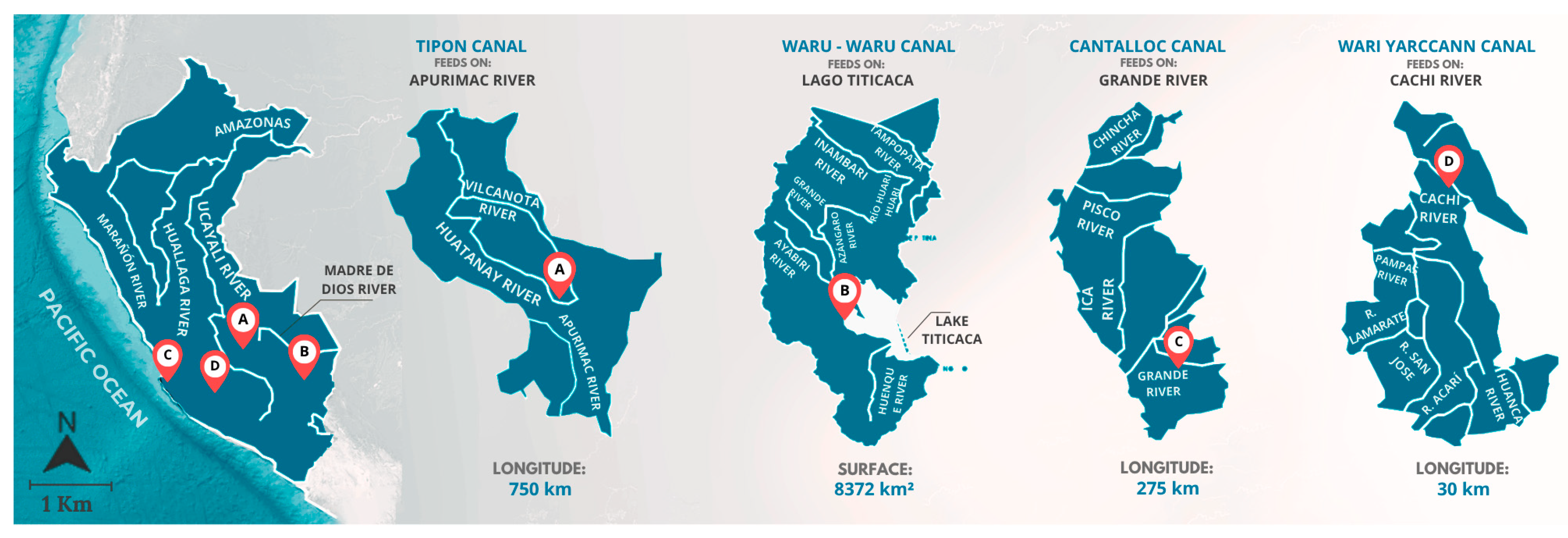
Figure 3. Hydrological map of Peru. (A) Apurimac River, Tipon. (B) Lake Titicaca, Waru-Waru. (C) Grande River, Cantalloc. (D) Cachi River, Wari Yarcann.
Heritage 08 00345 g003
Figure 4. (A) Map of the Cajamarca watershed, Upper Jequetepeque. (B) Map of the Upper Jequetepeque, Chonta River, and Cumbemayo canal.
Heritage 08 00345 g004
Figure 5. (A) Natural environmental factors in Cumbemayo that obstruct water flow. (B) Reinforcement of certain canal sections due to structural deterioration.
Heritage 08 00345 g005
Figure 6. Methodological framework.
Heritage 08 00345 g006
Figure 7. Steps for conducting the analysis. (A) Equator with topography file. (B) Rhinoceros with 3D model edits. (C) Google Earth Pro 2024 showing terrain sections. (D) Andrew’s blog assessing sunlight impact.
Heritage 08 00345 g007
Figure 8. (A) Map of Peru, Cajamarca. (B) Department of Cajamarca, province of Cajamarca. (C) Province of Cajamarca, district of Cajamarca.
Heritage 08 00345 g008
Figure 9. Climate analysis of Cumbemayo.
Heritage 08 00345 g009
Figure 10. Flora of Cumbemayo, Cajamarca.
Heritage 08 00345 g010
Figure 11. (A) Cajamarca district, Cumbemayo canal. (B) Map of the Cumbemayo canal.
Heritage 08 00345 g011
Figure 12. (A) Solar rotation analysis at 9:00 a.m. (B) Solar rotation analysis at 12:00 p.m. (C) Solar rotation analysis at 4:00 p.m.
Heritage 08 00345 g012
Figure 13. Topographic sections of the Cumbemayo canal and its surroundings.
Heritage 08 00345 g013
Figure 14. (A) Segment 1 with a straight element of the canal. (B) Segment 2 with a curved element of the canal. (C) Segment 3 with a zigzag element of the canal.
Heritage 08 00345 g014
Figure 15. (A) Meandering canal in the landscape. (B) Canal adhered to the mountain. (C) Canal passing through rocks.
Heritage 08 00345 g015
Figure 16. Layout of the Cumbemayo channel and signage of the forms. (A) Repetitive rhythm. (B) Alternating rhythm. (C) Progressive rhythm. (D) Irregular rhythm.
Heritage 08 00345 g016
Figure 17. Slope per kilometer of the Cumbemayo channel. (A) Curves and zigzags, reprinted with permission from ref. [17]. (B) Gentle slopes, reprinted with permission from ref. [17]. (C) Shrub barriers, reprinted with permission from ref. [17].
Heritage 08 00345 g017
Figure 18. Petroglyphs found in the Cumbemayo channels. (A) Andean crosses, reprinted with permission from ref. [18]. (B) Shining star, reprinted with permission from ref. [18]. (C) Stone with hieratic figures, reprinted with permission from ref. [18]. (D) Solitary block with two pairs of carved sandals, reprinted with permission from ref. [18].
Heritage 08 00345 g018
Figure 19. (A) Rock carving construction system. (B) Filling construction system. (C) Open-air channel construction system.
Heritage 08 00345 g019
Disclaimer/Publisher’s Note: The statements, opinions and data contained in all publications are solely those of the individual author(s) and contributor(s) and not of MDPI and/or the editor(s). MDPI and/or the editor(s) disclaim responsibility for any injury to people or property resulting from any ideas, methods, instructions or products referred to in the content.