
A Systematic Literature Review to Assist in Defining New Guidelines and Practical Handbooks for the Documentation of Built Heritage


Abstract
1. Introduction and Framing of the Research Project
Some Examples from the International Context
2. Systematic Literature Review Methodology
- Definition of the research question and eligibility criteria
- Identification and selection of the databases/sources for the SLR
- Definition of the search terms
- Checking data and looking for duplicates
- Inclusion or exclusion of the results (via screening by title, abstract, and full-text)
- Review
- Summary of the results
2.1. Search Terms and Eligibility Criteria
- It should be clear, simple, and straight to the point. What is the aim of the SLR? What questions should be answered, and what issues should be addressed?
- It must be defined before starting the SLR.
- It should be general enough to yield a broad range of results, yet sufficiently specific to keep the research focused on the topic of interest.
- Geomatics: “discipline concerned with the collection, distribution, storage, analysis, processing, presentation of geographic data or geographic information” [8];
- Digital technologies: all the instruments and techniques that produce data that are natively digital;
- 3D metric survey: a survey aimed at the 3D documentation of a specific asset that is metrically controlled and validated;
- Built heritage: single or groups of buildings. From well-preserved portions of historical structures to small urban centres (see Section 1 for more details).
- Geographical frame: no constraints
- Time frame: from 1 January 2014 to 31 December 2024
- Language: English
- Type of publication: Scientific manuscript (research articles, Reviews, Technical notes, Conference Proceedings, Book chapters)
- Type of review: at least single-blind
- Availability of full text for academics: yes
2.2. Identification and Selection of Databases
- Scopus by Elsevier13 uniquely combines a comprehensive, expertly curated abstract and citation database with enriched data and linked scholarly literature across various disciplines.
- Web of Science by Clarivate14 provides access to multiple databases that provide reference and citation data from academic journals, conference proceedings, and other documents in various academic disciplines.
2.3. Definition of Search Terms
- Title
- Keywords
- Abstract
3. Analysis of the SLR Results
3.1. Formal Analysis
3.2. Application of Eligibility Criteria
3.3. Summary of the Results: Co-Occurrence of Keyworks
3.4. Summary of the Results: Co-Authorship
4. Other Quantitative Analysis
5. Results of the SLR to Define Practical Handbooks
- Teaching and capacity building. This includes results that report activities related to university teachings or capacity-building initiatives connected to the documentation of built heritage. Summer schools, workshops, training experiences, and international exchange programmes are part of this topic.
- Topography/metric control (e.g., GCPs—Ground Control Points, CPs—Check Points). This concept includes all the search results where at least some minimal strategy for metric control and accuracy evaluation is considered. Generally speaking, this is achieved using traditional topographic techniques, but other strategies can be adopted as well.
- TLS (Terrestrial Laser Scanner). This concept is applied to all the results where the use of this technology is foreseen.
- Mobile Mapping Systems (MMS)/HMLS (Handheld Mobile Laser Scanner). This concept is applied to all the results where mobile mapping systems are used; more specifically, if the instruments are carried by the operators, these systems are referred to as HMLS.
- Terrestrial photogrammetry. This concept is for all the results where the use of this technique is foreseen.
- Aerial acquisitions (e.g., photogrammetry/LiDAR). For this concept, all the data acquired from the sky have been considered. These acquisitions are, in most cases, performed via UAV (Uncrewed Aerial Vehicles), but, for the architectural scale, they could also be performed by traditional aircraft.
- 2D drawings. This concept has been counted if the documentation process also led to the creation of traditional 2D representations.
- Other analyses (e.g., decay, cracks, FEM-Finite Elements Modelling, GPR—Ground Penetrating Radar). This voice was used to count all the sources that used the data acquired in the documentation process for performing several types of analyses.
- 3D model/HBIM (Historical Building Modelling). If the 3D data acquired in the documentation process led to the generation of 3D models in different forms (also HBIM), sources have been counted under this category.
- 360 (images or photogrammetry). This concept was used to count all the sources that reported the use of 360 data in terms of video, images, or photogrammetric approaches.
- VR (Virtual Reality)/AR (Augmented Reality)/ER (Extended Reality)/Virtual Tour. If one of the products of the documentation process falls into these categories, more related to the immersive dissemination of heritage, it has been counted in this voice.
- Risk assessment/management/post-event. If the experiences described in the results deal with some of the phases of risk assessment and management, they have been counted in this concept.
- Online viewer. This concept was used to report the sources where online viewers were created to disseminate the results of the documentation process.
- Other sensors (multi and hyperspectral/thermal). If other less commonly used sensors were adopted in the search results, they were counted here.
- Heritage management. If one of the declared aims of the work reported in the search results is the facilitation of the processes of heritage management, they were counted under this category.
- Point Cloud/Raster segmentation and classification. If AI (Artificial Intelligence) tools were used to segment and/or classify the data from the documentation process, sources were counted here.
- GIS (Geographical Information System). If the data of the documentation process is managed or analysed via GIS software, sources are counted under this category.
5.1. Topography/Metric Control (e.g., GCPs, CPs)
5.2. Acquisition Techniques
5.2.1. Terrestrial Laser Scanner
5.2.2. Photogrammetry
5.2.3. UAV
5.2.4. Mobile Mapping Systems/Handheld Mobile Laser Scanner
5.2.5. 360° Images
5.2.6. Other Sensors: Multispectral, Hyperspectral, and Thermal
5.3. Use of the Acquired Data
5.3.1. 2D Drawings
5.3.2. Other Analysis/Applications
5.3.3. Decay Analysis and Identification
5.3.4. FEM and Structural Analysis
5.3.5. GPR and Geophysics
5.3.6. HBIM/3D Models
5.3.7. VR/AR/XR/Virtual Tour
5.3.8. Online Viewer
5.3.9. GIS
5.3.10. Teaching and Capacity Building
5.4. Use of AI
6. Discussion and Conclusions
- Designing for objectives
- Data for supporting analyses
- Techniques for products
- Topography for accuracy and metric control
- Strategies for data processing and product generation
- Data for dissemination and management
- The design for objectives is the first phase of the process and starts with the definition of the objectives of the documentation process and the needs of the commissioner of the documentation. In this phase, preliminary research on already available materials on the object of documentation needs to be completed together with an in-depth reflection with the commissioner to try to understand the needs of the project. This is also the phase where the products that will be generated need to be defined, and also how these products will be used. The following phases of the documentation activities are linked to what is defined in this step. Preliminary knowledge of the site to be documented and the available preexisting materials is also crucial to designing the documentation process; an on-site visit is also advised.The design of the process will thus collect all the information retrieved in this phase and start setting up the necessary next steps. In the field of built heritage, it is also necessary to consider the conventional accuracy requested by the national or international entities in terms of traditional nominal scales of the products. In Italy, for example, the graphic error is by convention set to 0.2 mm (the minimum sise of a line plottable and recognisable by the human eye), and to simplify, this value is used to define the accuracy and tolerance acceptable at the different representational scales. Usually, this value is multiplied by the scale factor to obtain the accuracy of our products and doubled to obtain the tolerance. To recap, after defining the survey objectives, we defined the needed products and the relevant representational scale to adopt, and finally, we selected the appropriate techniques to meet the accuracy and tolerance defined using the graphic error.
- Data for supporting analyses is the next principle to be considered in the development of the documentation process. As clearly noticeable in the SLR, the documentation phase is always targeted at contributing to the knowledge process of the built heritage considered. In the search results, data are used in multiple ways to complete different types of analyses and support other research domains. Depending on the focus targeted by the knowledge process, it is necessary to adjust the documentation process. The examples reported in the previous sections are multiple: if the target is the decay or materials analysis, more effort in the documentation process must be placed on the radiometric information, which is crucial for this type of study. On the other hand, if structural analyses need to be performed, e.g., using FEM methodology, attention should be on the geometrical information. We have also seen that information coming from other sensors could be available, e.g., thermal or multispectral data, and these should be integrated into the documentation process as well. The coordination and cooperation with all the experts and the disciplines involved in the management and study of the documented built heritage is central and mandatory. Nevertheless, this is something that affects the overall strategy to be adopted in the documentation process and that needs to be considered in the design phase of the documentation activities. This phase is also connected to the final products, and thus, it influences the overall process, becoming the starting point of the process.
- The techniques for products step are where all the information gathered in the first phases is used to determine which approaches to use in the field to achieve the expected results. Several factors need to be considered in this phase. First of all, the final products to be delivered at the end of the process highly impact the choice of the techniques. The products have an impact in terms of level of detail, type of information, accuracy, etc. As described in the two previous steps, products need to be defined with the commissioner and all the other experts involved in the study of the heritage considered.What is clear in the SLR results is the fact that one single technique is hardly ever enough to satisfy all the needs of the documentation process. The solutions that are deployed are always based on multi-sensor and multi-scale approaches. This approach also led to a reflection on how to perform data fusion and integration, and the need to have operators that can deploy and manage complex processes. This is an aspect that needs to be considered as well when designing the documentation process and both the field and laboratory activities. The results of the SLR cover almost all the available geomatics techniques that could be deployed for built heritage documentation. TLS is a consolidated approach that is also often used as a ground reference for testing and validating new technologies. Photogrammetry still plays a central role and is still one of the preferred techniques thanks to its versatility, low cost, and automation level. The latter is deployed in the SLR both from the ground and using UAV systems. The aerial platforms have become more and more popular in recent years and are nowadays a consolidated approach in the field of built heritage documentation. In the realm of photogrammetry, spherical data faced a new growth in popularity, and despite being less consolidated in terms of data acquisition and processing, their use is rapidly growing, as reported by the number of results in the SLR. More recently, thanks to the evolution of portable devices and the sensors embedded in our smartphones, the use of personal devices is also gaining popularity. As described by the research present in the SLR, this technology is still evolving, and its use in the built heritage domain is still at an experimental stage, waiting to be evaluated and validated. Nevertheless, preliminary results are promising.Finally, HMLS are the newest topic in terms of data acquisition in recent years. These solutions have been deeply tested in the field of built heritage documentation and have proved to be a valid alternative in contexts where other techniques are less efficient, time is a crucial aspect, and some level of detail and accuracy can be sacrificed.
- Topography for accuracy and metric control emerged as a central theme in the SLR. Despite the technological evolution of the techniques available for the metric survey of built heritage, traditional topography is still a core expertise that needs to be deployed in the field. The documentation process and its products need to be metrically validated both during the data processing and within the final report delivered to the commissioner. Moreover, the generated products need to meet the expected accuracy defined at the beginning of the documentation process. To comply with this need, first and second-order control networks need to be implemented. Depending on several factors, GNSS or Total Station might be used alone or integrated. The choice of which techniques to use is related, for example, to the extension of the site, the need to work indoors or outdoors, the final accuracy expected from the products, the techniques chosen, etc.It is clear and well-known that first and second-order control networks should be carefully designed and documented, considering all the requirements described in the previous sections. Approaches of direct georeferencing have been developed and tested in the last few years, especially for photogrammetry in the UAV scenario; nevertheless, at this stage of development, they often still need to be supported by traditional topography.
- Strategies for data processing and product generation is the phase where data needs to be processed and interpreted after fieldwork. An aspect that emerged from the SLR is the fact that we assisted in the automation and speed-up of the fieldwork phases. Nowadays, considering the same level of operators’ expertise, it is easier to collect more data in less time; however, the discretization of data has been moved from the field to the office. The need for new strategies to manage and interpret the huge amount of data acquired in the field is clear in most of the SLR results. Aside from the optimisation of the standard processing pipeline, which is still a topic of research, attention has also been focused on the availability of new tools to enhance this phase. The use of AI is also reaching the geomatics field, with an approach that is sometimes referred to as GeoAI. These new tools might assist the researchers in managing the huge amount of data collected in the field and speed up the steps of data processing and interpretation. As emerged from the SLR, this field of research is strongly emerging, but it is in the early stage of development, and potentialities and limits need to be fully explored. In the SLR, the multifaceted nature of the products derived from the documentation process also emerged clearly. Excluding the need for traditional 2D drawings, which is still very often required, the attention in recent years has moved to more complex systems to manage 2D and 3D data. In particular, in the field of built heritage, HBIM and GIS have become a point of attention for researchers, driving a lot of the SLR results in deepening the use of these approaches and testing their potential.
- Data for dissemination and management is the last step of the documentation process. It is again clear in the SLR that several research groups invested their effort in designing strategies to share and disseminate the results of the documentation process. This dissemination can be performed at different levels and to different stakeholders. On the one side, it is a tool for the operators and the entities that are in charge of managing the considered heritage as well as performing important tasks like risk assessment, management, and post-disaster intervention. On the other side, it is a way to promote this heritage among citizens and local communities. The collected and processed data must be available via online platforms and tools to assist the processes of managing, protecting, and safeguarding heritage.
Supplementary Materials
Author Contributions
Funding
Data Availability Statement
Conflicts of Interest
| 1 | https://www.english-heritage.org.uk/ (accessed on 11 March 2025). |
| 2 | https://historicengland.org.uk/ (accessed on 11 March 2025). |
| 3 | https://www.icomos.org/ (accessed on 11 March 2025). |
| 4 | https://www.isprs.org/ (accessed on 11 March 2025). |
| 5 | https://www.cipaheritagedocumentation.org/ (accessed on 11 March 2025). |
| 6 | https://digitallibrary.cultura.gov.it/ (accessed on 11 March 2025). |
| 7 | https://digital-strategy.ec.europa.eu/en/library/basic-principles-and-tips-3d-digitisation-cultural-heritage (accessed on 11 March 2025). |
| 8 | |
| 9 | https://eureka3d.eu/ (accessed on 11 March 2025). |
| 10 | http://3dicons-project.eu/ (accessed on 11 March 2025). |
| 11 | https://www.3d4ch-competencecentre.eu/home (accessed on 11 March 2025). |
| 12 | https://www.prisma-statement.org/ (accessed on 11 March 2025). |
| 13 | https://www.elsevier.com/products/scopus (accessed on 11 March 2025). |
| 14 | |
| 15 | https://www.zotero.org/ (accessed on 11 March 2025). |
| 16 | https://www.vosviewer.com/ (accessed on 11 March 2025). |
References
- UNESCO. Convention Concerning the Protection of the World Cultural and Natural Heritage; UNESCO: Paris, France, 1972. [Google Scholar]
- Letellier, R. Recording, Documentation and Information Management for the Conservation of Heritage Places, 1st ed.; Routledge: London, UK, 2015; ISBN 978-1-315-79391-7. [Google Scholar]
- Andrews, D.; Bedford, J.; Bryan, P. Metric Survey Specifications for Cultural Heritage; Historic England: York, UK, 2009; ISBN 978-1-84802-296-6.
- Historic England. Geospatial Survey Specifications for Cultural Heritage; Historic England: York, UK, 2024.
- Page, M.J.; McKenzie, J.E.; Bossuyt, P.M.; Boutron, I.; Hoffmann, T.C.; Mulrow, C.D.; Shamseer, L.; Tetzlaff, J.M.; Akl, E.A.; Brennan, S.E.; et al. The PRISMA 2020 Statement: An Updated Guideline for Reporting Systematic Reviews. BMJ 2021, 372, n71. [Google Scholar] [CrossRef] [PubMed]
- Briner, R.; Denyer, D. Systematic Review and Evidence Synthesis as a Practice and Scholarship Tool. In Handbook of Evidence-Based Management: Companies, Classrooms and Research; Oxford University Press: Oxford, UK, 2012; pp. 112–129. ISBN 978-0-19-976398-6. [Google Scholar]
- Cooke, A.; Smith, D.; Booth, A. Beyond PICO: The SPIDER Tool for Qualitative Evidence Synthesis. Qual. Health Res. 2012, 22, 1435–1443. [Google Scholar] [CrossRef] [PubMed]
- ISO/TR 19122:2004(en); Geographic Information/Geomatics—Qualification and Certification of Personnel. ISO: Geneva, Switzerland, 2014.
- Webster, J.; Watson, R.T. Analyzing the Past to Prepare for the Future: Writing a Literature Review. MIS Q. 2002, 26, 13–23. [Google Scholar]
- De Fino, M.; Galantucci, R.; Fatiguso, F.; Ragia, L.; Moullou, D. Condition Assessment of Heritage Buildings via Photogrammetry: A Scoping Review from the Perspective of Decision Makers. Heritage 2023, 6, 7031–7066. [Google Scholar] [CrossRef]
- Münster, S. Digital Heritage as a Scholarly Field-Topics, Researchers, and Perspectives from a Bibliometric Point of View. ACM J. Comput. Cult. Herit. 2019, 12, 22. [Google Scholar] [CrossRef]
- Bonora, V.; Maseroli, R.; Mugnai, F.; Tucci, G. Gnns Control Network Supporting Large Historical Building Architectural Survey. Int. Arch. Photogramm. Remote Sens. Spat. Inf. Sci. 2021, 46, 87–91. [Google Scholar] [CrossRef]
- Betti, M.; Bonora, V.; Galano, L.; Pellis, E.; Tucci, G.; Vignoli, A. An Integrated Geometric and Material Survey for the Conservation of Heritage Masonry Structures. Heritage 2021, 4, 585–611. [Google Scholar] [CrossRef]
- Sammartano, G.; Patrucco, G.; Perri, S.; Ceravolo, R.; Lenticchia, E.; Spanò, A. Documenting Complexity for the 20th Century Heritage: The Enriched 3d Models of the Turin Exposition Nervi’s Halls Digitization. ISPRS Ann. Photogramm. Remote Sens. Spat. Inf. Sci. 2021, 8, 141–148. [Google Scholar] [CrossRef]
- Balletti, C.; Guerra, F. The Survey of Cultural Heritage: A Long Story. Rendiconti Lincei 2015, 26, 115–125. [Google Scholar] [CrossRef]
- Saulli, T.; Wahbeh, W.; Nardinocchi, C. 3D Survey and Digital Models as the First Documentation of Hypogeum of S. Saba in Rome. Appl. Geomat. 2018, 10, 377–384. [Google Scholar] [CrossRef]
- Ursini, A.; Grazzini, A.; Matrone, F.; Zerbinatti, M. From Scan-to-BIM to a Structural Finite Elements Model of Built Heritage for Dynamic Simulation. Autom. Constr. 2022, 142, 104518. [Google Scholar] [CrossRef]
- Bertellini, B.; Gottardi, C.; Vernier, P. 3D Survey Techniques for the Conservation and the Enhancement of a Venetian Historical Architecture. Appl. Geomat. 2020, 12, 53–68. [Google Scholar] [CrossRef]
- Castagnetti, C.; Dubbini, M.; Ricci, P.C.; Rivola, R.; Giannini, M.; Capra, A. Critical Issues and Key Points from the Survey to the Creation of the Historical Building Information Model: The Case of Santo Stefano Basilica. Int. Arch. Photogramm. Remote Sens. Spat. Inf. Sci. 2017, 42, 467–474. [Google Scholar] [CrossRef]
- Cordero, M.H. Geomatics Approach to Surveys for Late Antiquity Buildings. The Episcopal Palace in Side, Turkey. Archeol. E Calcolatori 2017, 28, 457–467. [Google Scholar] [CrossRef]
- Fabris, M.; Granotto, P.; Monego, M. Expeditious Low-Cost SfM Photogrammetry and a TLS Survey for the Structural Analysis of Illasi Castle (Italy). Drones 2023, 7, 101. [Google Scholar] [CrossRef]
- Piras, M.; Di Pietra, V.; Visintini, D. 3D Modeling of Industrial Heritage Building Using COTSs System: Test, Limits and Performances. Int. Arch. Photogramm. Remote Sens. Spat. Inf. Sci. 2017, 42, 281–288. [Google Scholar] [CrossRef]
- Selvaggi, I.; Bitelli, G.; Serantoni, E.; Wieser, A. Point Cloud Dataset and Fem for a Complex Geometry: The San Luzi Bell Tower Case Study. ISPRS Ann. Photogramm. Remote Sens. Spat. Inf. Sci. 2019, 42, 1047–1052. [Google Scholar] [CrossRef]
- Adami, A.; Treccani, D.; Fregonese, L. Lessons Learnt from the High-Resolution Uas Photogrammetric Survey of a Historic Urban Area: Unesco Site of Sabbioneta. Int. Arch. Photogramm. Remote Sens. Spat. Inf. Sci. 2023, 48, 19–25. [Google Scholar] [CrossRef]
- Al-Ruzouq, R.; Venkatachalam, S.; Abueladas, A.; Abu Dabous, S. Geomatics for Economic Archaeological Documentation and Management. Appl. Geomat. 2018, 10, 341–360. [Google Scholar] [CrossRef]
- Calantropio, A.; Chiabrando, F.; Sammartano, G.; Spanò, A.; Teppati Losè, L. UAV Strategies Validation and Remote Sensing Data for Damage Assessment in Post-Disaster Scenarios. Int. Arch. Photogramm. Remote Sens. Spat. Inf. Sci. 2018, 42, 121–128. [Google Scholar] [CrossRef]
- Bevilacqua, M.G.; Caroti, G.; Piemonte, A.; Ruschi, P.; Tenchini, L. 3D Survey Techniques for the Architectutal Restoration: The Case of St. Agata in Pisas. Int. Arch. Photogramm. Remote Sens. Spat. Inf. Sci. 2017, 42, 441–447. [Google Scholar] [CrossRef]
- Chiabrando, F.; Teppati Losè, L. Performance Evaluation of COTS UAV for Architectural Heritage Documentation. A Test on s.Giuliano Chapel in Savigliano (CN)—Italy. Int. Arch. Photogramm. Remote Sens. Spat. Inf. Sci. 2017, 42, 77–84. [Google Scholar] [CrossRef]
- Garcia-Leon, J.; Murrieri, P.; Collado-Espejo, P.E. Hbim as a Tool for the Analysis and Conservation of Architectural Heritage. Case Study: The Rame Tower’s Digital Twin. Int. Arch. Photogramm. Remote Sens. Spat. Inf. Sci. 2023, 48, 637–644. [Google Scholar] [CrossRef]
- Lo Brutto, M.; Dardanelli, G.; Ebolese, D.; Milazzo, G.; Pipitone, C.; Sciortino, R. The Main Portal of the Cathedral of Monreale: First Geometric Analysis and Interpretive Assessment of Architectural Features. Int. Arch. Photogramm. Remote Sens. Spat. Inf. Sci. 2017, 42, 381–387. [Google Scholar] [CrossRef]
- Ebolese, D.; Lo Brutto, M.; Dardanelli, G. The Integrated 3d Survey for Underground Archaeological Environment. ISPRS Ann. Photogramm. Remote Sens. Spat. Inf. Sci. 2019, 42, 311–317. [Google Scholar] [CrossRef]
- Lo Brutto, M.; Iuculano, E.; Lo Giudice, P. Integrating Topographic, Photogrammetric and Laser Scanning Techniques for a Scan-to-Bim Process. Int. Arch. Photogramm. Remote Sens. Spat. Inf. Sci. 2021, 43, 883–890. [Google Scholar] [CrossRef]
- Mahasuwanchai, P.; Athisakul, C.; Sairuamyat, P.; Tangchirapat, W.; Leelataviwat, S.; Chucheepsakul, S. An Alternative Method for Long-Term Monitoring of Thai Historic Pagodas Based on Terrestrial Laser Scanning Data: A Case Study of Wat Krachee in Ayutthaya. Adv. Civ. Eng. 2021, 2021, 5587046. [Google Scholar] [CrossRef]
- Sairuamyat, P.; Mahasuwanchai, P.; Athisakul, C.; Leelataviwat, S.; Chucheepsakul, S. Application of 3D Laser Scanning Technology for Preservation and Monitoring of Thai Pagoda: A Case Study of Wat Krachee Ayutthaya. IOP Conf. Ser. Earth Environ. Sci. 2020, 463, 012082. [Google Scholar] [CrossRef]
- Aricò, M.; Lo Brutto, M.; Maltese, A. A Scan-to-BIM Approach for the Management of Two Arab-Norman Churches in Palermo (Italy). Heritage 2023, 6, 1622–1644. [Google Scholar] [CrossRef]
- Bianchini, C.; Russo, M. Massive 3D Acquisition of CH. In Proceedings of the 2018 3rd Digital Heritage International Congress (Digital HERITAGE) Held Jointly with 2018 24th International Conference on Virtual Systems & Multimedia (VSMM 2018), San Francisco, CA, USA, 26–30 October 2018. [Google Scholar]
- Grillo, S.M.; Pilia, E.; Vacca, G. Protocols of Knowledge for the Restoration: Documents, Geomatics, Diagnostic. The Case of the Beata Vergine Assunta Basilic in Guasila (Sardinia). In Lecture Notes in Computer Science (Including Subseries Lecture Notes in Artificial Intelligence and Lecture Notes in Bioinformatics); Springer: Cham, Switzerland, 2022; Volume 13379 LNCS, pp. 670–685. [Google Scholar]
- Macher, H.; Grussenmeyer, P.; Kraemer, C.; Guillemin, S. Overview of 3D Documentation Data and Tools Available for Archaeological Researches: Case Study of the Romanesque Church of Dugny-Sur-Meuse (France). Int. Arch. Photogramm. Remote Sens. Spat. Inf. Sci. 2015, 40, 323–330. [Google Scholar] [CrossRef]
- Patrucco, G.; Chiabrando, F.; Dameri, A.; Teppati Losè, L. Geomatic Contribution for the Restoration Project of the Valentino Castle Green Room. From Data Acquisition to Integrated Documentation. Int. Arch. Photogramm. Remote Sens. Spat. Inf. Sci. 2020, 43, 885–892. [Google Scholar] [CrossRef]
- Rodríguez-Gonzálvez, P.; Nocerino, E.; Menna, F.; Minto, S.; Remondino, F. 3d Surveying & Modeling Of Underground Passages in Wwi Fortifications. Int. Arch. Photogramm. Remote Sens. Spat. Inf. Sci. 2015, 40, 17–24. [Google Scholar]
- Ronchi, D.; Limongiello, M.; Ribera, F. Field Work Monitoring and Heritage Documentation for the Conservation Project. The “Foro Emiliano” in Terracina (Italy). Int. Arch. Photogramm. Remote Sens. Spat. Inf. Sci. 2019, 42, 1031–1037. [Google Scholar] [CrossRef]
- Russo, M.; Panarotto, F.; Flenghi, G.; Russo, V.; Pellegrinelli, A. Ultralight UAV for Steep-Hill Archaeological 3D Survey. DISEGNARECON 2022, 15, 3.1–3.17. [Google Scholar] [CrossRef]
- Teppati Losè, L.; Sammartano, G.; Chiabrando, F.; Spanò, A. Challenging Multi-Sensor Data Models and Use of 360 Images. The Twelve Months Fountain of Valentino Park in Turin. IOP Conf. Ser. Earth Environ. Sci. 2020, 949, 012060. [Google Scholar] [CrossRef]
- Monego, M.; Fabris, M.; Menin, A.; Achilli, V. 3-D Survey Applied to Industrial Archaeology by Tls Methodology. Int. Arch. Photogramm. Remote Sens. Spat. Inf. Sci. 2017, 42, 449–454. [Google Scholar] [CrossRef]
- Monego, M.; Menin, A.; Fabris, M.; Achilli, V. 3D Survey of Sarno Baths (Pompeii) by Integrated Geomatic Methodologies. J. Cult. Herit. 2019, 40, 240–246. [Google Scholar] [CrossRef]
- Montesanto, M.; Carletti, M.; Alvaro, C.; Pucci, M.; Saad, H. 3D Scanning for the Preservation of the Archaeological Heritage: The Case of Amrit (Syria) 3d. Int. Arch. Photogramm. Remote Sens. Spat. Inf. Sci. 2023, 48, 1073–1080. [Google Scholar] [CrossRef]
- Pavelka, K.J.; Pacina, J. Using Of Modern Technologies for Visualization of Cultural Heritage. Civ. Eng. J.-STAVEBNI Obz. 2023, 32, 549–563. [Google Scholar] [CrossRef]
- Radulescu, V.; Radulescu, G.; Nas, S.; Radulescu, A.; Bondrea, M.; Radulescu, C. Synthetic Analysis Of Geoinformatics Technologies for Preservation of Cultural Heritage, Methodological Approach. J. Appl. Eng. Sci. 2021, 11, 33–40. [Google Scholar] [CrossRef]
- Vacca, G.; Dessi, A. Geomatics Supporting Knowledge of Cultural Heritage Aimed at Recovery and Restoration. Int. Arch. Photogramm. Remote Sens. Spat. Inf. Sci. 2022, 43, 909–915. [Google Scholar] [CrossRef]
- Allegra, V.; Di Paola, F.; Lo Brutto, M.; Vinci, C. SCAN-TO-BIM for the MANAGEMENT of HERITAGE BUILDINGS: The CASE STUDY of the CASTLE of MAREDOLCE (PALERMO, ITALY). Int. Arch. Photogramm. Remote Sens. Spat. Inf. Sci. 2020, 43, 1355–1362. [Google Scholar] [CrossRef]
- Bolognesi, C.; Fiorillo, F. Virtual Representations of Cultural Heritage: Sharable and Implementable Case Study to Be Enjoyed and Maintained by the Community. Buildings 2023, 13, 410. [Google Scholar] [CrossRef]
- Alshawabkeh, Y. Color and Laser Data as a Complementary Approach for Heritage Documentation. Remote Sens. 2020, 12, 3465. [Google Scholar] [CrossRef]
- Aricò, M.; La Guardia, M.; Lo Brutto, M. 3D Data Integration for Web Fruition of Underground Archaeological Sites: A Web Navigation System for the Hypogeum of Crispia Salvia (Marsala, Italy). Heritage 2023, 6, 5899–5918. [Google Scholar] [CrossRef]
- Chiabrando, F.; Di Pietra, V.; Lingua, A.; Maschio, P.; Noardo, F.; Sammartano, G.; Spanò, A. TLS Models Generation Assisted By UAV Survey. Int. Arch. Photogramm. Remote Sens. Spat. Inf. Sci. 2016, 41, 413–420. [Google Scholar] [CrossRef]
- Grasso, N.; Spadavecchia, C.; Di Pietra, V.; Belcore, E. LiDAR and SfM-MVS Integrated Approach to Build a Highly Detailed 3D Virtual Model of Urban Areas. In Proceedings of the 9th International Conference on Geographical Information Systems Theory, Applications and Management, GISTAM—Proceedings, Lisbon, Portugal, 25–27 April 2023; Volume 2023-April, pp. 128–135. [Google Scholar]
- Aicardi, I.; Chiabrando, F.; Maria Lingua, A.; Noardo, F. Recent Trends in Cultural Heritage 3D Survey: The Photogrammetric Computer Vision Approach. J. Cult. Herit. 2018, 32, 257–266. [Google Scholar] [CrossRef]
- Calantropio, A.; Colucci, E.; Teppati Losè, L. Rapid Mapping for Built Heritage at Risk Using Low-Cost and Cots Sensors. A Test in the Duomo Vecchio of San Severino Marche. Int. Arch. Photogramm. Remote Sens. Spat. Inf. Sci. 2017, 42, 59–66. [Google Scholar] [CrossRef]
- Calantropio, A.; Patrucco, G.; Sammartano, G.; Teppati Losè, L. Low-Cost Sensors for Rapid Mapping of Cultural Heritage: First Tests Using a COTS Steadicamera. Appl. Geomat. 2018, 10, 31–45. [Google Scholar] [CrossRef]
- Carraro, F.; Monego, M.; Callegaro, C.; Mazzariol, A.; Perticarini, M.; Menin, A.; Achilli, V.; Bonetto, J.; Giordano, A. The 3d Survey of the Roman Bridge of San Lorenzo in Padova (Italy): A Comparison Between Sfm and Tls Methodologies Applied to the Arch Structure. Int. Arch. Photogramm. Remote Sens. Spat. Inf. Sci. 2019, 42, 255–262. [Google Scholar] [CrossRef]
- Hanna, E.; Paonessa, A. Using Geomatics to Understand and Valorize Heritage, Three Different Contexts of Study: Syria, Italy, and France. Int. Arch. Photogramm. Remote Sens. Spat. Inf. Sci. 2019, 42, 601–608. [Google Scholar] [CrossRef]
- Gagliolo, S.; Ausonio, E.; Federici, B.; Ferrando, I.; Passoni, D.; Sguerso, D. 3D Cultural Heritage Documentation: A Comparison between Different Photogrammetric Software and Their Products. Int. Arch. Photogramm. Remote Sens. Spat. Inf. Sci. 2018, 42, 347–354. [Google Scholar] [CrossRef]
- Giannaris, I.; Gerotziafa, M.; Prantsidi, M.; Karachaliou, E.; Stylianidis, E. 3d Surveying and Modelling of Roman Monument with Arch. Int. Arch. Photogramm. Remote Sens. Spat. Inf. Sci. 2019, 42, 509–512. [Google Scholar] [CrossRef]
- Gil-Piqueras, T.; Rodríguez-Navarro, P.; Revuelta, E.C.; Álvarez, E.G. Preliminary Studies of the Coastal Defenses of Cullera’s Cape Built during the Spanish Civil War: From Historical Study to Formal Analysis. Heritage 2022, 5, 3032–3048. [Google Scholar] [CrossRef]
- Condorelli, F.; Rinaudo, F. Benchmark of Metric Quality Assessment in Photogrammetric Reconstruction for Historical Film Footage. ISPRS Ann. Photogramm. Remote Sens. Spat. Inf. Sci. 2019, 42, 443–448. [Google Scholar] [CrossRef]
- Condorelli, F.; Rinaudo, F. Processing Historical Film Footage with Photogrammetry and Machine Learning for Cultural Heritage Documentation. In SUMAC’19: Proceedings of the 1st Workshop on Structuring and Understanding of Multimedia heritAge Contents; Association for Computing Machinery Inc.: New York, NY, USA, 2019; pp. 39–46. [Google Scholar]
- Balletti, C.; D’Agnano, F.; Guerra, F.; Vernier, P. From Point Cloud to Digital Fabrication: A Tangible Reconstruction of Ca’ Venier Dei Leoni, the Guggenheim Museum in Venice. ISPRS Ann. Photogramm. Remote Sens. Spat. Inf. Sci. 2016, 3, 43–49. [Google Scholar]
- Bevilacqua, M.G.; Caroti, G.; Piemonte, A.; Ulivieri, D. Reconstruction Of Lost Architectural Volumes By Integration Of Photogrammetry from Archive Imagery with 3-D Models of the Status Quo. ISPRS Ann. Photogramm. Remote Sens. Spat. Inf. Sci. 2019, 42, 119–125. [Google Scholar] [CrossRef]
- Mandelli, A.; Gobeil, C.; Greco, C.; Rossi, C. Digital Twin and 3D Documentation of a Theban Tomb at Deir Al-Medina (EGYPT) Using a Multi-Lenses Photogrammetric Approach. Int. Arch. Photogramm. Remote Sens. Spat. Inf. Sci. 2021, 43, 591–597. [Google Scholar] [CrossRef]
- Perfetti, L.; Fassi, F. Handheld Fisheye Multicamera System: Surveying Meandering Architectonic Spaces In Open-Loop Mode—Accuracy Assessment. Int. Arch. Photogramm. Remote Sens. Spat. Inf. Sci. 2022, 46, 435–442. [Google Scholar] [CrossRef]
- Perfetti, L.; Fassi, F.; Gulsan, H. Generation of Gigapixel Orthophoto for the Maintenance of Complex Buildings. Challenges and Lesson Learnt. ISPRS Ann. Photogramm. Remote Sens. Spat. Inf. Sci. 2019, 42, 605–614. [Google Scholar] [CrossRef]
- Teppati Losè, L.; Matrone, F.; Chiabrando, F.; Giulio Tonolo, F.; Lingua, A.; Maschio, P. New Developments in Lidar Uas Surveys. Performance Analyses and Validation of the Dji Zenmuse L1. Int. Arch. Photogramm. Remote Sens. Spat. Inf. Sci. 2022, 43, 415–422. [Google Scholar] [CrossRef]
- Adami, A.; Chiarini, S.; Cremonesi, S.; Fregonese, L.; Taffurelli, L.; Valente, M.V. The Survey of Cultural Heritage after an Earthquake: The Case of Emilia-Lombardia in 2012. Int. Arch. Photogramm. Remote Sens. Spat. Inf. Sci. 2016, 41, 161–168. [Google Scholar] [CrossRef]
- Avena, M.; Colucci, E.; Sammartano, G.; Spanò, A. HBIM Modelling for an Historical Urban Centre. Int. Arch. Photogramm. Remote Sens. Spat. Inf. Sci. 2021, 43, 831–838. [Google Scholar] [CrossRef]
- Brusa, E. Digital Storage and the Data Collection for the Seismic Prevention: A Comparison from the Italian Recent Experiences. ISPRS Ann. Photogramm. Remote Sens. Spat. Inf. Sci. 2019, 42, 325–329. [Google Scholar] [CrossRef]
- Chiabrando, F.; Di Lolli, A.; Patrucco, G.; Spanò, A.; Sammartano, G.; Teppati Losè, L. Multitemporal 3D Modelling for Cultural Heritage Emergency during Seismic Events: Damage Assessment of S. Agostino Church in Amatrice (RI). Int. Arch. Photogramm. Remote Sens. Spat. Inf. Sci. 2017, 42, 69–76. [Google Scholar] [CrossRef]
- Croce, V.; Martínez-Espejo Zaragoza, I. UAV-Based 3D Photogrammetry for Post-Earthquake Studies on Seismic Damaged Cities—A Case Study: Castelluccio Di Norcia. Proc. IMSCI 2018, 2, 79–84. [Google Scholar]
- D’Auria, S.; Luglio, M.; Roseti, C.; Strollo, R.M.; Zampognaro, F. Real Time Transmission of Cultural Heritage 3d Survey in Case of Emergency. In Proceedings of the 3rd International Conference on Information and Communication Technologies for Disaster Management (ICT-DM), Vienna, Austria, 13–15 December 2016; Duro, R., Pielorz, J., Preinerstorfer, A., Eds.; Institute of Electrical and Electronics Engineers Inc.: New York, NY, USA, 2017. [Google Scholar]
- Grazzini, A.; Chiabrando, F.; Foti, S.; Sammartano, G.; Spanò, A. A Multidisciplinary Study on the Seismic Vulnerability of St. Agostino Church in Amatrice Following the 2016 Seismic Sequence. Int. J. Archit. Herit. 2020, 14, 885–902. [Google Scholar] [CrossRef]
- Baratti, V.; Quercia, G.; Renghini, G. Between Architecture and Digital Twin: The 3d Survey of the Visconti Tower of the Famous Monza Park. Archeomatica-Tecnol. BENI Cult. 2023, 14, 12–15. [Google Scholar]
- Barrile, V.; Bernardo, E.; Fotia, A.; Bilotta, G. Integration of Laser Scanner, Ground-Penetrating Radar, 3D Models and Mixed Reality for Artistic, Archaeological and Cultural Heritage Dissemination. Heritage 2022, 5, 1529–1550. [Google Scholar] [CrossRef]
- Bonora, V.; Centauro, I.; Fiorini, L.; Conti, A.; Salvatici, T.; Calandra, S.; Raffa, R.; Intrieri, E.; Garzonio, C.A.; Tucci, G. Virtual Inspection Based on 3d Survey Supporting Risks Detachment Analysis in Pietraforte Stone-Built Heritage. Int. Arch. Photogramm. Remote Sens. Spat. Inf. Sci. 2023, 48, 273–280. [Google Scholar] [CrossRef]
- Calantropio, A.; Chiabrando, F.; Rinaudo, F.; Teppati Losè, L. Use and Evaluation of a Short Range Small Quadcopter and a Portable Imaging Laser for Built Heritage 3D Documentation. Int. Arch. Photogramm. Remote Sens. Spat. Inf. Sci. 2018, 42, 71–78. [Google Scholar] [CrossRef]
- Casimiro-Bernárdez, J.M.; Martínez-Carricondo, P.; Agüera-Vega, F.; Carvajal-Ramírez, F. Fem Structural Analysis from Uav Photogrammetry Projects. Case Study: Twenty Eyes Aqueduct in the Wadi of Carcauz (Almeria, Spain). Conserv. Sci. Cult. Herit. 2023, 23, 111–139. [Google Scholar] [CrossRef]
- Chiabrando, F.; Spanò, A.; Sammartano, G.; Teppati Losè, L. UAV Oblique Photogrammetry and LiDAR Data Acquisition for 3D Documentation of the Hercules Fountain. Virtual Archaeol. Rev. 2017, 8, 83–96. [Google Scholar] [CrossRef]
- Martínez-Carricondo, P.; Casimiro-Bernández, J.M.; Agüera-Vega, F.; Carvajal-Ramírez, F. Structural Weakness of the Twenty Eyes Aqueduct in the Wadi of Carcauz (Almeria, Spain). Int. Arch. Photogramm. Remote Sens. Spat. Inf. Sci. 2023, 48, 1021–1025. [Google Scholar] [CrossRef]
- Palestini, C.; Basso, A. Geomatics as a Survey Tool to Document and Enhance the Cultural and Landscaped Heritage of the Monumental Complexes in the Mountains of Abruzzo. Int. Arch. Photogramm. Remote Sens. Spat. Inf. Sci. 2017, 42, 373–380. [Google Scholar] [CrossRef]
- Simou, S.; Baba, K.; Nounah, A. The Integration of 3D Technology for the Conservation and Restoration of Ruined Archaeological Artifacts. Hist. Sci. Technol. 2022, 12, 150–168. [Google Scholar] [CrossRef]
- Enríquez, C.; Jurado, J.M.; Bailey, A.; Callén, D.; Collado, M.J.; Espina, G.; Marroquín, P.; Oliva, E.; Osla, E.; Ramos, M.I.; et al. The UAS-Based 3D Image Characterization of Mozarabic Church Ruins in Bobastro (Malaga), Spain. Remote Sens. 2020, 12, 2377. [Google Scholar] [CrossRef]
- Pavelka, K.; Šedina, J.; Pavelka, K. Combined Precise Documentation And Virtual Reconstruction Of Prophet Nahum Shrine In Alqosh, Iraq. Int. Arch. Photogramm. Remote Sens. Spat. Inf. Sci. 2019, 42, 909–913. [Google Scholar] [CrossRef]
- Alicandro, M.; Candigliota, E.; Dominici, D.; Immordino, F.; Quaresima, R.; Zollini, S. Alba Fucens Archaeological Site: Multiscale and Multidisciplinary Approach for Risk Assessment and Conservation. ISPRS Ann. Photogramm. Remote Sens. Spat. Inf. Sci. 2019, 42, 47–53. [Google Scholar] [CrossRef]
- Brocchini, D.; Chiabrando, F.; Colucci, E.; Sammartano, G.; Spanò, A.; Teppati Losè, L.; Villa, A. The Geomatics Contribution for the Valorisation Project in the Rocca of San Silvestro Landscape Site. Int. Arch. Photogramm. Remote Sens. Spat. Inf. Sci. 2017, 42, 495–502. [Google Scholar] [CrossRef]
- Demetrescu, E.; d’Annibale, E.; Ferdani, D.; Fanini, B. Digital Replica of Cultural Landscapes: An Experimental Reality-Based Workflow to Create Realistic, Interactive Open World Experiences. J. Cult. Herit. 2020, 41, 125–141. [Google Scholar] [CrossRef]
- Pepe, M.; Alfio, V.S.; Costantino, D. UAV Platforms and the SfM-MVS Approach in the 3D Surveys and Modelling: A Review in the Cultural Heritage Field. Appl. Sci. 2022, 12, 12886. [Google Scholar] [CrossRef]
- Yordanov, V.; Mostafavi, A.; Scaioni, M. Distance-Training for Image-Based 3d Modelling of Archeological Sites in Remote Regions. Int. Arch. Photogramm. Remote Sens. Spat. Inf. Sci. 2019, 42, 1165–1172. [Google Scholar] [CrossRef]
- Stöcker, C.; Nex, F.; Koeva, M.; Gerke, M. Quality Assessment of Combined Imu/Gnss Data for Direct Georeferencing in the Context of Uav-Based Mapping. Int. Arch. Photogramm. Remote Sens. Spat. Inf. Sci. 2017, XLII-2-W6, 355–361. [Google Scholar] [CrossRef]
- Liu, X.; Lian, X.; Yang, W.; Wang, F.; Han, Y.; Zhang, Y. Accuracy Assessment of a UAV Direct Georeferencing Method and Impact of the Configuration of Ground Control Points. Drones 2022, 6, 30. [Google Scholar] [CrossRef]
- Aricò, M.; La Guardia, M.; Lo Brutto, M.; Rappa, E.M.; Vinci, C. Mobile Mapping for Cultural Heritage: The Survey of the Complex of St. John of the Hermits in Palermo (Italy). Int. Arch. Photogramm. Remote Sens. Spat. Inf. Sci. 2023, 48, 25–32. [Google Scholar] [CrossRef]
- Rinaudo, F.; Scolamiero, V. Comparison of Multi-Source Data, Integrated Survey for Complex Architecture Documentation. Int. Arch. Photogramm. Remote Sens. Spat. Inf. Sci. 2021, 46, 625–631. [Google Scholar] [CrossRef]
- Chiabrando, F.; Naretto, M.; Sammartano, G.; Sambuelli, L.; Spanò, A.; Teppati Losè, L. The 4dilan Project (4th Dimension in Landscape and Artifacts Analyses). Int. Arch. Photogramm. Remote Sens. Spat. Inf. Sci. 2017, 42, 227–234. [Google Scholar] [CrossRef]
- Matoušková, E.; Pavelka, K.; Smolík, T.; Pavelka, K. Earthen Jewish Architecture of Southern Morocco: Documentation of Unfired Brick Synagogues and Mellahs in the Drâa-Tafilalet Region. Appl. Sci. 2021, 11, 1712. [Google Scholar] [CrossRef]
- Chiabrando, F.; Della Coletta, C.; Sammartano, G.; Spanò, A.; Spreafico, A. “TORINO 1911” Project: A Contribution of a SLAM-Based Survey to Extensive 3D Heritage Modeling. Int. Arch. Photogramm. Remote Sens. Spat. Inf. Sci. 2018, 42, 225–234. [Google Scholar] [CrossRef]
- Chiabrando, F.; Sammartano, G.; Spanò, A.; Spreafico, A. Hybrid 3D Models: When Geomatics Innovations Meet Extensive Built Heritage Complexes. ISPRS Int. J. Geo-Inf. 2019, 8, 124. [Google Scholar] [CrossRef]
- Di Stefano, F.; Torresani, A.; Farella, E.; Pierdicca, R.; Menna, F.; Remondino, F. 3D Surveying of Underground Built Heritage: Opportunities and Challenges of Mobile Technologies. Sustainability 2021, 13, 13289. [Google Scholar] [CrossRef]
- Franzini, M.; Casella, V.; Niglio, O. Leica Blk2go Point Cloud Classification with Machine Learning Algorithms: The Case Study of Sant’eusebio’s Crypt in Pavia (Italy). Int. Arch. Photogramm. Remote Sens. Spat. Inf. Sci. 2023, 48, 593–600. [Google Scholar] [CrossRef]
- Gorgoglione, L.; Malinverni, E.S.; Smaniotto Costa, C.; Pierdicca, R.; Di Stefano, F. Exploiting 2D/3D Geomatics Data for the Management, Promotion, and Valorization of Underground Built Heritage. Smart Cities 2023, 6, 243–262. [Google Scholar] [CrossRef]
- Tanduo, B.; Teppati Losè, L.; Chiabrando, F. Documentation of Complex Environments in Cultural Heritage Sites. A Slam-Based Survey in the Castello Del Valentino Basement. Int. Arch. Photogramm. Remote Sens. Spat. Inf. Sci. 2023, 48, 489–496. [Google Scholar] [CrossRef]
- Martino, A.; Breggion, E.; Balletti, C.; Guerra, F.; Renghini, G.; Centanni, P. Digitization Approaches for Urban Cultural Heritage: Last Generation Mms Within Venice Outdoor Scenarios. Int. Arch. Photogramm. Remote Sens. Spat. Inf. Sci. 2023, 48, 265–272. [Google Scholar] [CrossRef]
- Remondino, F.; Gaiani, M.; Apollonio, F.; Ballabeni, A.; Ballabeni, M.; Morabito, D. 3D Documentation Of 40 Kilometers Of Historical Porticoes—The Challenge. Int. Arch. Photogramm. Remote Sens. Spat. Inf. Sci. 2016, 41, 711–718. [Google Scholar] [CrossRef]
- Parrinello, S.; Picchio, F.; De Marco, R. IEEE Documentation Systems for an Urban Renewal Proposal in Developing Territories: The Digitalization Project of Bethlehem Historical Center. In Proceedings of the 2018 Metrology for Archaeology and Cultural Heritage (MetroArchaeo), Cassino, Italy, 22–24 October 2018; pp. 216–221. [Google Scholar]
- Porcelli, F.; Sambuelli, L.; Comina, C.; Spanò, A.; Lingua, A.; Calantropio, A.; Catanzariti, G.; Chiabrando, F.; Fischanger, F.; Maschio, P.; et al. Integrated Geophysics and Geomatics Surveys in the Valley of the Kings. Sensors 2020, 20, 1552. [Google Scholar] [CrossRef]
- Rabbia, A.; Sammartano, G.; Spanò, A. Fostering Etruscan Heritage with Effective Integration of UAV, TLS and SLAM-Based Methods. In Proceedings of the IMEKO TC-4 International Conference on Metrology for Archaeology and Cultural Heritage, Trento, Italy, 22–24 October 2020; International Measurement Confederation (IMEKO): Budapest, Hungary, 2020; pp. 322–327. [Google Scholar]
- Di Stefano, F.; Gorreja, A.; Malinverni, E.S.; Mariotti, C. Knowledge Modeling for Heritage Conservation Process: From Survey to Hbim Implementation. Int. Arch. Photogramm. Remote Sens. Spat. Inf. Sci. 2020, 44, 19–26. [Google Scholar] [CrossRef]
- Pavelka, K.; Kuzmanov, P.; Pavelka, K.; Rapuca, A. Different Data Joining as a Basic Model for Hbim—A Case Project St. Pataleimon in Skopje. Int. Arch. Photogramm. Remote Sens. Spat. Inf. Sci. 2023, 48, 85–91. [Google Scholar] [CrossRef]
- Roman, O.; Farella, E.; Rigon, S.; Remondino, F.; Ricciuti, S.; Viesi, D. From 3d Surveying Data To Bim To Bem: The Incube Dataset. Int. Arch. Photogramm. Remote Sens. Spat. Inf. Sci. 2023, 48, 175–182. [Google Scholar] [CrossRef]
- Di Stefano, F.; Sanita, M.; Malinverni, E.S.; Doti, G. Geomatic Technologies to Valorize Historical Watermills. Int. Arch. Photogramm. Remote Sens. Spat. Inf. Sci. 2023, 48, 511–518. [Google Scholar] [CrossRef]
- Cappellazzo, M.; Baldo, M.; Sammartano, G.; Spano, A. Integrated Airborne Lidar-Uav Methods for Archaeological Mapping in Vegetation-Covered Areas. Int. Arch. Photogramm. Remote Sens. Spat. Inf. Sci. 2023, 48, 357–364. [Google Scholar] [CrossRef]
- Adami, A.; Fregonese, L. Geomatics in the Management of Built Heritage Through Bim Systems. The Training of New Experienced Professional Figures. Int. Arch. Photogramm. Remote Sens. Spat. Inf. Sci. 2020, 43, 9–14. [Google Scholar] [CrossRef]
- Matrone, F.; Colucci, E.; Ugliotti, F.M.; Del Giudice, M. From an Integrated Survey with Mms to a Scan-To-Bim Process for Educational Purposes. Int. Arch. Photogramm. Remote Sens. Spat. Inf. Sci. 2023, 48, 279–286. [Google Scholar] [CrossRef]
- Teppati Losè, L.; Spreafico, A.; Chiabrando, F.; Tonolo, F. Apple LiDAR Sensor for 3D Surveying: Tests and Results in the Cultural Heritage Domain. Remote Sens. 2022, 14, 4157. [Google Scholar] [CrossRef]
- Vacca, G. 3D Survey with Apple LiDAR Sensor—Test and Assessment for Architectural and Cultural Heritage. Heritage 2023, 6, 1476–1501. [Google Scholar] [CrossRef]
- Vacca, G.; Dessi, A. Low-Cost Geomatics Surveys for Emergency Interventions on Cultural Heritage. The Case of Historic Wall in Cagliari. In Proceedings of the International Conference on Computational Science and Its Applications, Athens, Greece, 3–6 July 2023; Volume 14111 LNCS, pp. 650–664. [Google Scholar]
- Fangi, G. The Multi-Image Spherical Panoramas as a Tool for Architectural Survey. CIPA Herit. Doc. 2011, 21, 311–316. [Google Scholar]
- Angeloni, R.; Mariotti, C.; Petetta, L.; Coppetta, L. Enabling Scan-To-Bim Workflow for Heritage Conservation and Management Process. Int. Arch. Photogramm. Remote Sens. Spat. Inf. Sci. 2023, 48, 79–86. [Google Scholar] [CrossRef]
- Achille, C.; Fassi, F.; Mandelli, A.; Del Pero, C.; Leonforte, F.; Aste, N. Designing Remote Places in the Post-War and Pandemic Scenarios. Smart Surveying of the Gahayr Campus in Mogadishu. Int. Arch. Photogramm. Remote Sens. Spat. Inf. Sci. 2021, 46, 1–8. [Google Scholar] [CrossRef]
- Ramos, A.P.; Prieto, G.R. Only Image Based for the 3D Metric Survey of Gothic Structures by Using Frame Cameras and Panoramic Cameras. Int. Arch. Photogramm. Remote Sens. Spat. Inf. Sci. 2016, 41, 363–370. [Google Scholar] [CrossRef]
- Calantropio, A.; Chiabrando, F.; Einaudi, D.; Teppati Losè, L. 360° Images for Uav Multisensor Data Fusion: First Tests and Results. Int. Arch. Photogramm. Remote Sens. Spat. Inf. Sci. 2019, 42, 227–234. [Google Scholar] [CrossRef]
- Gómez-López, J.; García, J.; Mozas-Calvache, A.; Vico-García, D. Documentation of Cultural Heritage Through the Fusion of Geomatic Techniques. Case Study of the Cloister of “Santo Domingo” (JAEN, SPAIN). Int. Arch. Photogramm. Remote Sens. Spat. Inf. Sci. 2023, XLVIII-M-2-2023, 677–683. [Google Scholar] [CrossRef]
- Balletti, C.; Bertellini, B.; Gottardi, C.; Guerra, F. Geomatics Techniques for the Enhancement and Preservation of Cultural Heritage. ISPRS Ann. Photogramm. Remote Sens. Spat. Inf. Sci. 2019, 42, 133–140. [Google Scholar] [CrossRef]
- Paolini, P.; Forti, G.; Catalani, G.; Lucchetti, S.; Menghini, A.; Mirandola, A.; Pistacchio, S.; Porzia, U.; Roberti, M. From “Sapienza” to “Sapienza, State Archives in Rome”. A Looping Effect Bringing Back to the Original Source Communication and Culture by Innovative and Low-Cost 3d Surveying, Imaging Systems and Gis Applications. ISPRS Ann. Photogramm. Remote Sens. Spat. Inf. Sci. 2016, 40, 17–24. [Google Scholar]
- Piccinini, F.; Gorreja, A.; Di Stefano, F.; Pierdicca, R.; Sanchez Aparicio, L.J.; Malinverni, E.S. Preservation of Villages in Central Italy: Geomatic Techniques’ Integration and GIS Strategies for the Post-Earthquake Assessment. ISPRS Int. J. Geo-Inf. 2022, 11, 291. [Google Scholar] [CrossRef]
- Alkhatib, Y.J.; Forte, A.; Bitelli, G.; Pierdicca, R.; Malinverni, E. Bringing Back Lost Heritage into Life by 3D Reconstruction in Metaverse and Virtual Environments: The Case Study of Palmyra, Syria. In Lecture Notes in Computer Science (Including Subseries Lecture Notes in Artificial Intelligence and Lecture Notes in Bioinformatics); Springer: Cham, Switzerland, 2023; Volume 14219 LNCS, pp. 91–106. [Google Scholar]
- Fangi, G. ALEPPO—Before and After. ISPRS Ann. Photogramm. Remote Sens. Spat. Inf. Sci. 2019, 42, 333–338. [Google Scholar] [CrossRef]
- Martino, A.; Balletti, C. From Point Cloud to Video Projection Mapping: Knowing Modern Architecture by Using Light Projection. J. Phys. Conf. Ser. 2022, 2204, 012063. [Google Scholar] [CrossRef]
- Adamopoulos, E.; Rinaudo, F.; Volinia, M.; Girotto, M. Multispectral Sensing and Data Integration for the Study of Heritage Architecture. Eng. Proc. 2020, 2, 64. [Google Scholar] [CrossRef]
- Giuffrida, D.; Nardo, V.M.; Neri, D.; Cucinotta, G.; Calabrò, I.V.; Pace, L.; Ponterio, R.C. A Multi-Analytical Study for the Enhancement and Accessibility of Archaeological Heritage: The Churches of San Nicola and San Basilio in Motta Sant’agata (Rc, Italy). Remote Sens. 2021, 13, 3738. [Google Scholar] [CrossRef]
- Artese, S.; Lerma, J.L.; Aznar Molla, J.; Sánchez, R.M.; Zinno, R. Integration of Surveying Techniques to Detect the Ideal Shape of a Dome: The Case of the Escuelas Pías Church in Valencia. ISPRS Ann. Photogramm. Remote Sens. Spat. Inf. Sci. 2019, 42, 39–43. [Google Scholar] [CrossRef]
- Del Curto, D.; Garzulino, A.; Malik, U.S. Fast or Extensive-Comparing Workflows for the Geometrical Analysis of the Built Heritage. Int. Arch. Photogramm. Remote Sens. Spat. Inf. Sci. 2023, 48, 473–480. [Google Scholar] [CrossRef]
- Martino, A.; Gerla, F.; Balletti, C. Multi-Scale and Multi-Sensor Approaches for the Protection of Cultural Natural Heritage: The Island of Santo Spirito in Venice. Int. Arch. Photogramm. Remote Sens. Spat. Inf. Sci. 2023, 48, 1027–1034. [Google Scholar] [CrossRef]
- Monterroso-checa, A.; Redondo-villa, A.; Gasparini, M.; Hornero, A.; Iraci, B.; Martín-talaverano, R.; Moreno-escribano, J.C.; Muñoz-cádiz, J.; Murillo-fragero, J.I.; Obregón-romero, R.; et al. A Heritage Science Workflow to Preserve and Narrate a Rural Archeological Landscape Using Virtual Reality: The Cerro Del Castillo of Belmez and Its Surrounding Environment (Cordoba, Spain). Appl. Sci. 2020, 10, 8659. [Google Scholar] [CrossRef]
- Hernández Oroza, A.; Diomedes Almeida, A.; Romeo Sáez, A.; Cuétara Pérez, P.R. Diagnosis and Solutions Proposal to the Damages Present in the Ceiling of the Convent of Santa Clara de Asís. Rev. Alconpat 2022, 12, 296–310. [Google Scholar] [CrossRef]
- Martín-Lerones, P.; Olmedo, D.; López-Vidal, A.; Gómez-García-Bermejo, J.; Zalama, E. BIM Supported Surveying and Imaging Combination for Heritage Conservation. Remote Sens. 2021, 13, 1584. [Google Scholar] [CrossRef]
- Patrucco, G.; Gómez, A.; Adineh, A.; Rahrig, M.; Lerma, J.L. 3D Data Fusion for Historical Analyses of Heritage Buildings Using Thermal Images: The Palacio de Colomina as a Case Study. Remote Sens. 2022, 14, 5699. [Google Scholar] [CrossRef]
- Mugnai, F.; Lombardi, L.; Tucci, G.; Nocentini, M.; Gigli, G.; Fanti, R. Geomatics in Bridge Structural Health Monitoring, Integrating Terrestrial Laser Scanning Techniques and Geotechnical Inspections on a High-Value Cultural Heritage. ISPRS Ann. Photogramm. Remote Sens. Spat. Inf. Sci. 2019, 42, 895–900. [Google Scholar] [CrossRef]
- Bacci, G.; Bertolini, F.; Bevilacqua, M.G.; Caroti, G.; Martínez-Espejo Zaragoza, I.; Martino, M.; Piemonte, A. Hbim Methodologies for the Architectural Restoration. The Case of the Ex-Church of San Quirico All’olivo in Lucca, Tuscany. ISPRS Ann. Photogramm. Remote Sens. Spat. Inf. Sci. 2019, 42, 121–126. [Google Scholar] [CrossRef]
- Balzani, M.; Maietti, F. Architectural Space in a Protocol for an Integrated 3d Survey Aimed at the Documentation, Representation and Conservation of Cultural Heritage. Disegno 2017, 2017, 113–122. [Google Scholar] [CrossRef]
- Costantino, D.; Pepe, M.; Restuccia, A.G. Scan-to-HBIM for Conservation and Preservation of Cultural Heritage Building: The Case Study of San Nicola in Montedoro Church (Italy). Appl. Geomat. 2023, 15, 607–621. [Google Scholar] [CrossRef]
- Croce, V.; Caroti, G.; Piemonte, A.; Bevilacqua, M.G. Geomatics for Cultural Heritage Conservation: Integrated Survey and 3D Modeling. In Proceedings of the IMEKO TC-4 International Conference on Metrology for Archaeology and Cultural Heritage, Florence, Italy, 4–6 December 2019; pp. 271–276. [Google Scholar]
- Croce, V.; Caroti, G.; Piemonte, A.; Bevilacqua, M.G. From Survey to Semantic Representation for Cultural Heritage: The 3D Modelling of Recurring Architectural Elements. Acta IMEKO 2021, 10, 98–108. [Google Scholar] [CrossRef]
- D’Agostino, P.; Antuono, G.; Elefante, E.; Amore, R. Digital Management for the Restoration Project. The Case of the Temple of Venus in Baia. Int. Arch. Photogramm. Remote Sens. Spat. Inf. Sci. 2023, 48, 461–471. [Google Scholar] [CrossRef]
- Delpozzo, D.; Treccani, D.; Appolonia, L.; Adami, A.; Scala, B. Hbim and Thematic Mapping: Preliminary Results. Int. Arch. Photogramm. Remote Sens. Spat. Inf. Sci. 2022, 46, 199–206. [Google Scholar] [CrossRef]
- Di Giulio, R.; Maietti, F.; Piaia, E. Advanced 3D Survey and Modelling for Enhancement and Conservation of Cultural Heritage: The INCEPTION Project. In International Conference on Transdisciplinary Multispectral Modeling and Cooperation for the Preservation of Cultural Heritage; Springer: Cham, Switzerland, 2019; Volume 962, pp. 325–335. [Google Scholar]
- Miceli, A.; Morandotti, M.; Parrinello, S. 3D Survey and Semantic Analysis for the Documentation of Built Heritage. The Case Study of Palazzo Centrale of Pavia University. Vitruvio 2020, 5, 65–80. [Google Scholar] [CrossRef]
- Palestini, C.; Basso, A. Cultural Projects and Geomatic Surveys for the Resilience of School Heritage. ISPRS Ann. Photogramm. Remote Sens. Spat. Inf. Sci. 2019, 42, 937–944. [Google Scholar] [CrossRef]
- Saricaoglu, T. Conservation model for basilica of smyrna as an theoretical intention. In Proceedings of the 8th International Congress on Archaeology, Computer Graphics, Cultural Heritage and Innovation, Valencia, Spain, 5–7 September 2016; pp. 215–219. [Google Scholar]
- Stanga, C.; Hasníková, H.; Brumana, R.; Grimoldi, A.; Banfi, F. Geometric Primitives Assessing Italian-Czech Vault Construction Techniques in Baroque Period. ISPRS Ann. Photogramm. Remote Sens. Spat. Inf. Sci. 2019, 42, 1081–1088. [Google Scholar] [CrossRef]
- Tan, J.; Leng, J.; Zeng, X.; Feng, D.; Yu, P. Digital Twin for Xiegong’s Architectural Archaeological Research: A Case Study of Xuanluo Hall, Sichuan, China. Buildings 2022, 12, 1053. [Google Scholar] [CrossRef]
- Tucci, G.; Conti, A.; Fiorini, L. Geomatics for Structural Assessment and Surface Diagnostic of CH. Procedia Struct. Integr. 2018, 11, 2–11. [Google Scholar] [CrossRef]
- Allegretti, F.; Del Curto, D.; Mazza, S. Advanced geomatics and conservation management plan for preserving 20th century architectural heritage. Int. Arch. Photogramm. Remote Sens. Spat. Inf. Sci. 2019, XLII-2/W11, 63–70. [Google Scholar] [CrossRef]
- Barrile, V.; Genovese, E.; Meduri, G.M. Application of Geomatics Techniques for Cultural Heritage Mapping and Creation of an Unsafe Buildings’ Cadastre. WSEAS Trans. Environ. Dev. 2023, 19, 798–807. [Google Scholar] [CrossRef]
- Collado, A.; Heras, V.; Rodas, P.; Delgado, A.; Carrión, C.; Mora-Navarro, G.; Lerma, J.L. Geomatics Documentation Techniques as Monitoring Tools for Rural Built Heritage in Nabón (Ecuador). ISPRS Ann. Photogramm. Remote Sens. Spat. Inf. Sci. 2021, 8, 65–72. [Google Scholar] [CrossRef]
- Collado, A.; Mora-Navarro, G.; Heras, V.; Lerma, J.L. A Web-Based Geoinformation System for Heritage Management and Geovisualisation in Cantón Nabón (Ecuador). ISPRS Int. J. Geo-Inf. 2022, 11, 4. [Google Scholar] [CrossRef]
- Iandelli, N.; Coli, M.; Donigaglia, T.; Ciuffreda, A.L. An Unconventional Field Mapping Application: A Complete Opensource Workflow Solution Applied to Lithological Mapping of the Coatings of Cultural Heritage. ISPRS Int. J. Geo-Inf. 2021, 10, 357. [Google Scholar] [CrossRef]
- Malinverni, E.S.; Pierdicca, R.; Giuliano, A.; Mariano, F. A Geographical Information System to Support Restoration Activities: A Methodological Approach Experienced upon the Case Study of Ascoli Satriano Fortress. Appl. Geomat. 2018, 10, 427–439. [Google Scholar] [CrossRef]
- Balletti, C.; Ballarin, M.; Faccio, P.; Guerra, F.; Saetta, A.; Vernier, P. 3D Survey and 3D Modelling for Seismic Vulnerability Assessment of Historical Masonry Buildings. Appl. Geomat. 2018, 10, 473–484. [Google Scholar] [CrossRef]
- Cortés-Pérez, J.P.; Núñez-Fernández, M.; Cortés-Pérez, A.; Jiménez-Espada, M. First Application of Reinforced Concrete in Spain and First European Application in Bridges: The Rehabilitation of the Roman Bridge of Alcántara. Case Stud. Constr. Mater. 2023, 19, e02350. [Google Scholar] [CrossRef]
- Costantino, D.; Carrieri, M.; Garofalo, A.; Angelini, M.; Baiocchi, V.; Bogdan, A. Integrated Survey for Tensional Analysis of the Vault of the Church of San Nicola in Montedoro. Int. Arch. Photogramm. Remote Sens. Spat. Inf. Sci. 2019, 42, 455–460. [Google Scholar] [CrossRef]
- Fregonese, L.; Campera, A.; Scala, B.; Adami, A. The 2012 Earthquake: An Abacus of Surveys & Interventions in Mantua Churches. Int. Arch. Photogramm. Remote Sens. Spat. Inf. Sci. 2017, 42, 31–38. [Google Scholar]
- Bitelli, G.; Castellazzi, G.; D’Altri, A.M.; De Miranda, S.; Lambertini, A.; Selvaggi, I. On the Generation of Numerical Models from Point Clouds for the Analysis of Damaged Cultural Heritage. IOP Conf. Ser. Earth Environ. Sci. 2018, 364, 012083. [Google Scholar] [CrossRef]
- Cozzolino, M.; Di Meo, A.; Gentile, V. The Contribution of Indirect Topographic Surveys (Photogrammetry and Laser Scanner) and Gpr Investigations in the Study of the Vulnerability of the Abbey of Santa Maria a Mare, Tremiti Islands (Italy). Ann. Geophys. 2019, 62, SE343. [Google Scholar] [CrossRef]
- Fiorillo, F.; Perfetti, L.; Cardani, G. Automated Mapping of the Roof Damage in Historic Buildings in Seismic Areas with UAV Photogrammetry. Procedia Struct. Integr. 2022, 44, 1672–1679. [Google Scholar] [CrossRef]
- Funari, M.F.; Hajjat, A.E.; Masciotta, M.G.; Oliveira, D.V.; Lourenço, P.B. A Parametric Scan-to-FEM Framework for the Digital Twin Generation of Historic Masonry Structures. Sustainability 2021, 13, 11088. [Google Scholar] [CrossRef]
- Girelli, V.A.; Borgatti, L.; Dellapasqua, M.; Mandanici, E.; Spreafico, M.C.; Tini, M.A.; Bitelli, G. Integration of Geomatics Techniques for Digitizing Highly Relevant Geological and Cultural Heritage Sites: The Case of San Leo (Italy). Int. Arch. Photogramm. Remote Sens. Spat. Inf. Sci. 2017, 42, 281–286. [Google Scholar] [CrossRef]
- Manferdini, A.M. Documenting Lost Heritage: The Experience of the Survey of Architectures Damaged by the Earthquake in the Emilia Area, Italy. In Built Heritage: Monitoring Conservation Management. Research for Development; Springer: Cham, Switzerland, 2015; pp. 323–333. ISBN 21987300. [Google Scholar]
- Marsella, S.; Marzoli, M.; Anastasi, D. Ensuring Safety of Cultural Heritage Experts While Safeguarding Historical Buildings: The 3D Survey of the Sacro Convento Di Assisi as Benchmark to Test Innovative Emergency Management Procedures. In Proceedings of the 2022 IEEE International Workshop on Metrology for Living Environment (MetroLivEn), Cosenza, Italy, 25–27 May 2022; Institute of Electrical and Electronics Engineers Inc.: New York, NY, USA, 2022; pp. 91–95. [Google Scholar]
- Mataloni, G.; Palumbo, D.; Pepe, M.; Varagnoli, C. A Multiscale Geomatic Approach for the Survey of Historic Centres Main Streets: The Case Study of Capitignano, Italy. Geogr. Tech. 2023, 18, 113–122. [Google Scholar] [CrossRef]
- Oreni, D.; Brumana, R.; Torre, S.D.; Banfi, F. Survey, HBIM and Conservation Plan of a Monumental Building Damaged by Earthquake. Int. Arch. Photogramm. Remote Sens. Spat. Inf. Sci. 2017, 42, 337–342. [Google Scholar] [CrossRef]
- Parrinello, S.; de Marco, R. Digital Surveying and 3D Modelling Structural Shape Pipelines for Instability Monitoring in Historical Buildings: A Strategy of Versatile Mesh Models for Ruined and Endangered Heritage. Acta IMEKO 2021, 10, 84–97. [Google Scholar] [CrossRef]
- Pepe, M.; Costantino, D.; Crocetto, N.; Restuccia Garofalo, A. 3D Modeling of Roman Bridge by the Integration of Terrestrial and UAV Photogrammetric Survey for Structural Analysis Purpose. Int. Arch. Photogramm. Remote Sens. Spat. Inf. Sci. 2019, 42, 249–255. [Google Scholar] [CrossRef]
- Pepe, M.; Costantino, D.; Garofalo, A.R. An Efficient Pipeline to Obtain 3D Model for HBIM and Structural Analysis Purposes from 3D Point Clouds. Appl. Sci. 2020, 10, 1235. [Google Scholar] [CrossRef]
- Raco, F. Integrated Digital Platforms for the Documentation and Management of Cultural Heritage at Risk. Int. Arch. Photogramm. Remote Sens. Spat. Inf. Sci. 2022, 48, 45–52. [Google Scholar] [CrossRef]
- Sánchez-Aparicio, L.J.; Masciotta, M.G.; Pellegrini, D.; Conde, B.; Girardi, M.; Padovani, C.; Ramos, L.F.; Riveiro, B. A Multidisciplinary Approach Integrating Geomatics, Dynamic Field Testing and Finite Element Modelling to Evaluate the Conservation State of the guimarÃes Castle’S Tower Keep. In Proceedings of the XI International Conference on Structural Dynamics Eurodyn, Athens, Greece, 23–26 November 2020. [Google Scholar]
- Tucci, G.; Bonora, V. Geomatics and Management of At-Risk Cultural Heritage. Rendiconti Lincei 2015, 26, 105–114. [Google Scholar] [CrossRef]
- Dominici, D.; Alicandro, M.; Rosciano, E.; Massimi, V. Multiscale Documentation and Monitoring of l’aquila Historical Centre Using Uav Photogrammetry. Int. Arch. Photogramm. Remote Sens. Spat. Inf. Sci. 2017, 42, 365–371. [Google Scholar] [CrossRef]
- Canciani, M.; Saccone, M. The Representation of Cultural Heritage from Traditional Drawing to 3D Survey: The Case Study of Casamary’s Abbey. Int. Arch. Photogramm. Remote Sens. Spat. Inf. Sci. 2016, 41, 199–205. [Google Scholar] [CrossRef]
- Balzani, M.; Rossato, L. The Lost Memory of Industrial Places: The Ipanema Blast Furnace. Int. Arch. Photogramm. Remote Sens. Spat. Inf. Sci. 2022, 46, 41–48. [Google Scholar] [CrossRef]
- Camagni, F.; Colaceci, S.; Russo, M. Reverse modeling of cultural heritage: Pipeline and bottlenecks. ISPRS Ann. Photogramm. Remote Sens. Spat. Inf. Sci. 2019, 42, 197–204. [Google Scholar] [CrossRef]
- Spadaro, A.; Chiabrando, F.; Teppati Losè, L. 3D Metric Survey of the Mezzagnone Arab Bath. From Point Clouds to 2D Drawings and Parametric Model. In Proceedings of the IMEKO TC-4 International Conference on Metrology for Archaeology and Cultural Heritage, Rome, Italy, 19–21 October 2023; pp. 429–434. [Google Scholar]
- Donato, E.; Giuffrida, D. Combined Methodologies for the Survey and Documentation of Historical Buildings: The Castle of Scalea (Cs, Italy). Heritage 2019, 2, 2384–2397. [Google Scholar] [CrossRef]
- Fiorino, D.R.; Grillo, S.M.; Pilia, E.; Vacca, G. Geomatics and Archaeometric Investigations for the Sustainable Reuse of Ruins. The Santa Chiara Convent Ruin in Cagliari (Sardinia). ISPRS Ann. Photogramm. Remote Sens. Spat. Inf. Sci. 2019, 42, 525–532. [Google Scholar]
- Sammartano, G.; Spanò, A. High Scale 3d Modelling and Orthophoto of Curved Masonries for a Multipurpose Representation, Analysis and Assessment. Int. Arch. Photogramm. Remote Sens. Spat. Inf. Sci. 2017, 42, 245–252. [Google Scholar] [CrossRef]
- Guidi, G.; Micoli, L.; Gonizzi Barsanti, S.; Malik, U. The CHT2 Project: Diachronic 3D Reconstruction of Historic Sites. Int. Arch. Photogramm. Remote Sens. Spat. Inf. Sci. 2017, 42, 309–316. [Google Scholar] [CrossRef]
- Guidi, G.; Micoli, L.L.; Malik, U. 4D Reconstruction by Multi-Source Data Fusion: The Case of the Hidden Roman Circus in Milan. In Proceedings of the 3rd Digital Heritage International Congress (Digital Heritage) Held Jointly with 2018 24th International Conference on Virtual Systems & Multimedia (VSMM 2018); San Francisco, CL, USA, 26–30 October 2018, Addison, A.C., Thwaites, H., Eds.; Institute of Electrical and Electronics Engineers Inc.: New York, NY, USA, 2018. [Google Scholar]
- Micoli, L.; Barsanti, S.G.; Malik, U.; Guidi, G. 3D Data Integration for the Digital Reconstruction of Cultural Heritage Monuments. IOP Conf. Ser. Earth Environ. Sci. 2018, 364, 012043. [Google Scholar] [CrossRef]
- Tucci, G.; Conti, A.; Fiorini, L. 3-D Survey and Structural Modelling: The Case of the San Giovanni Baptistery in Florence. In Proceedings of the Digital Heritage. Progress in Cultural Heritage: Documentation, Preservation, and Protection: 7th International Conference, EuroMed; Nicosia, Cyprus, 29 October–3 November 2018, Ioannides, M., Fink, E., Brumana, R., Patias, P., Doulamis, A., Martins, J., Wallace, M., Eds.; Springer: Cham, Switzerland, 2018; Volume 11196, pp. 271–280. [Google Scholar]
- Costa-Jover, A.; Ginovart, J.; Coll-Pla, S.; Piquer, M.; Samper-Sosa, A.; García, D.; Lorenzo, a. 3D surveying and geometric assessment of a gothic nave vaulting from point clouds. Int. Arch. Photogramm. Remote Sens. Spat. Inf. Sci. 2017, 42, 203–208. [Google Scholar] [CrossRef]
- Versaci, A.; Cardaci, A.; Fauzìa, L.R.; Russo, M. The Aragonese Castle of Piazza Armerina, Sicily: New Surveys for the Conservation and the Valorisation of a Cultural Resource. Int. Arch. Photogramm. Remote Sens. Spat. Inf. Sci. 2021, 46, 777–784. [Google Scholar] [CrossRef]
- Iovane, D.; Cera, V. 3d Survey and Hbim for the Knowledge and Valorization of Archeological Heritage. The Case Studies of the Capua and Telesia Amphitheatres. In Proceedings of the 8th International Congress on Archaeology, Computer Graphics, Cultural Heritage and Innovation, Valencia, Spain, 5–7 September 2016; pp. 464–467. [Google Scholar]
- Versaci, A.; Fauzìa, L.R.; Russo, M.; Cardaci, A. The Integrated Fast Survey for the Risk Assessment. A Proposal for the Safeguarding of the Medieval Castles in Central Sicily. Int. Arch. Photogramm. Remote Sens. Spat. Inf. Sci. 2020, 54, 893–900. [Google Scholar] [CrossRef]
- Grillo, S.M.; Pilia, E.; Vacca, G. Integrated Study of the Beata Vergine Assunta Dome with Structure from Motion and Diagnostic Approaches. ISPRS Ann. Photogramm. Remote Sens. Spat. Inf. Sci. 2019, 42, 579–585. [Google Scholar] [CrossRef]
- Lima, R.; Sykora, T.; Meyer, M.D.; Willems, H.; Vergauwen, M. On Combining Epigraphy, Tls, Photogrammetry, and Interactive Media for Heritage Documentation: The Case Study of Djehutihotep’s Tomb in Dayr al-Barsha. In Proceedings of the GCH—Eurographics Workshop Graph, Vienna, Austria, 12–15 November 2018; pp. 225–229. [Google Scholar]
- Moise, C.; Lazar, A.-M.; Mihalache, C.E.; Dedulescu, L.A.; Dana Negula, I.F.; Badea, A.; Poenaru, V.D.; Moise, R.; Ortan, A.R. Geomatics Technologies in the Framework of Multidisciplinary Project for Integrated Management of Cultural Heritage Sites. Int. Arch. Photogramm. Remote Sens. Spat. Inf. Sci. 2020, 43, 1477–1484. [Google Scholar] [CrossRef]
- Balzani, M.; Maietti, F.; Mugayar Kühl, B. Point Cloud Analysis for Conservation and Enhancement of Modernist Architecture. Int. Arch. Photogramm. Remote Sens. Spat. Inf. Sci. 2017, 42, 71–77. [Google Scholar] [CrossRef]
- Balzani, M.; Maietti, F.; Rossato, L. 3d Data Processing Toward Maintenance and Conservation. The Integrated Digital Documentation of Casa De Vidro. ISPRS Ann. Photogramm. Remote Sens. Spat. Inf. Sci. 2019, 42, 65–72. [Google Scholar] [CrossRef]
- Azzola, P.; Cardaci, A.; Versaci, A. Integrated 3d Survey and Diagnostic Analysis for the Building Engineering: The Former Kindergarten San Filippo Neri in Dalmine. Int. Arch. Photogramm. Remote Sens. Spat. Inf. Sci. 2019, 42, 51–56. [Google Scholar] [CrossRef]
- Battini, C.; Vecchiattini, R. Data Parametric Representation for Monitoring of Cultural Heritage. Appl. Geomat. 2018, 10, 191–204. [Google Scholar] [CrossRef]
- Lanzara, E.; Scandurra, S.; Musella, C.; Palomba, D.; Di Luggo, A.; Asprone, D. Documentation of Structural Damage and Material Decay Phenomena in H-Bim Systems. Int. Arch. Photogramm. Remote Sens. Spat. Inf. Sci. 2021, 46, 375–382. [Google Scholar] [CrossRef]
- Quintilla, M.; Agustín, L. 3D Survey and Virtual Reconstruction of Heritage. The Case Study of the City Council and Lonja of Alcañiz. Vitruvio 2021, 6, 12–25. [Google Scholar] [CrossRef]
- Tommasi, C.; Fiorillo, F.; Jiménez Fernández-Palacios, B.; Achille, C. ACCESS and Web-Sharing of 3d Digital Documentation of Environmental and Architectural Heritage. ISPRS Ann. Photogramm. Remote Sens. Spat. Inf. Sci. 2019, 42, 707–714. [Google Scholar] [CrossRef]
- Idjaton, K.; Janvier, R.; Balawi, M.; Desquesnes, X.; Brunetaud, X.; Treuillet, S. Detection of Limestone Spalling in 3D Survey Images Using Deep Learning. Autom. Constr. 2023, 152, 104919. [Google Scholar] [CrossRef]
- Siu, S.L.K. Application of 3d Scanning Technology in Restoration of Heritage Site Damaged by Natural Disaster. Int. Arch. Photogramm. Remote Sens. Spat. Inf. Sci. 2021, 46, 685–691. [Google Scholar] [CrossRef]
- Catuogno, R.; Amore, R.; Terracciano, M. 3D Survey and Material Characterization of the Archaeological Complex of the Stadium of Antonino Pio in Pozzuoli. Int. Arch. Photogramm. Remote Sens. Spat. Inf. Sci. 2023, 48, 385–395. [Google Scholar] [CrossRef]
- Moreno-Garcia, D.; Coll-Pla, S.; Costa-Jover, A.; Samper-Sosa, A. 3d Surveying and Formal Analysis of a Structural Bay of a Gothic Apse. Int. Arch. Photogramm. Remote Sens. Spat. Inf. Sci. 2022, 46, 381–387. [Google Scholar] [CrossRef]
- Alfio, V.S.; Costantino, D.; Garofalo, A.R.; Herban, S.; Pepe, M. From TLS Data into H-FEM Model Based on the Quad-Mesh: The Case Study of Romanian Church. In Proceedings of the IMEKO TC-4 International Conference on Metrology for Archaeology and Cultural Heritage, Rome, Italy, 19–21 October 2023; pp. 356–360. [Google Scholar]
- Arce, A.; Ramos, L.; Fernandes, F.; Sánchez-Aparicio, L.; Lourenço, P. Integrated Structural Safety Analysis of San Francisco Master Gate in the Fortress of Almeida. Int. J. Archit. Herit. 2018, 12, 761–778. [Google Scholar] [CrossRef]
- Bitelli, G.; Balletti, C.; Brumana, R.; Barazzetti, L.; D’Urso, M.G.; Rinaudo, F.; Tucci, G. Metric Documentation of Cultural Heritage: Research Directions from the Italian Gamher Project. Int. Arch. Photogramm. Remote Sens. Spat. Inf. Sci. 2017, 42, 83–90. [Google Scholar] [CrossRef]
- Bitelli, G.; Balletti, C.; Brumana, R.; Barazzetti, L.; D’Urso, M.G.; Rinaudo, F.; Tucci, G. The Gamher Research Project for Metric Documentation of Cultural Heritage: Current Developments. ISPRS Ann. Photogramm. Remote Sens. Spat. Inf. Sci. 2019, 42, 239–246. [Google Scholar] [CrossRef]
- Rodríguez-Gonzálvez, P.; Muñoz-Nieto, A.; Gozalo-Sanz, I.; Mancera-Taboada, J.; González-Aguilera, D.; Carrasco-Morillo, P. Geomatics and Geophysics Synergies to Evaluate Underground Wine Cellars. Int. J. Archit. Herit. 2014, 8, 537–555. [Google Scholar] [CrossRef]
- Cozzolino, M.; Gabrielli, R.; Galatà, P.; Gentile, V.; Greco, G.; Scopinaro, E. Combined Use of 3D Metric Surveys and Non-Invasive Geophysical Surveys at the Stylite Tower (UMM AR-RASAS, JORDAN). Ann. Geophys. 2019, 62, SE339. [Google Scholar] [CrossRef]
- Banfi, F. Hbim Generation: Extending Geometric Primitives and Bim Modelling Tools for Heritage Structures and Complex Vaulted Systems. Int. Arch. Photogramm. Remote Sens. Spat. Inf. Sci. 2019, 42, 139–148. [Google Scholar] [CrossRef]
- Banfi, F.; Stanga, C.; Brumana, R. A Digital Workflow for Built Heritage: From SCAN-to-BIM Process to the VR-Tour of the Basilica of Sant’Ambrogio in Milan. In Proceedings of the Digital Heritage. Progress in Cultural Heritage: Documentation, Preservation, and Protection: 7th International Conference, EuroMed 2018; Nicosia, Cyprus, 29 October–3 November 2018, Lecture Notes in Computer Science (Including Subseries Lecture Notes in Artificial Intelligence and Lecture Notes in Bioinformatics); Springer: Cham, Switzerland, 2018; Volume 11196 LNCS, pp. 334–343. [Google Scholar]
- Barrile, V.; Bernardo, E.; Bilotta, G. An Experimental HBIM Processing: Innovative Tool for 3D Model Reconstruction of Morpho-Typological Phases for the Cultural Heritage. Remote Sens. 2022, 14, 1288. [Google Scholar] [CrossRef]
- Chiabrando, F.; Sammartano, G.; Spanò, A. Historical Buildings Models and Their Handling via 3d Survey: From Points Clouds to User-Oriented Hbim. Int. Arch. Photogramm. Remote Sens. Spat. Inf. Sci. 2016, 41, 633–640. [Google Scholar] [CrossRef]
- Maietti, F.; Di Giulio, R.; Medici, M.; Ferrari, F.; Piaia, E.; Brunoro, S. Accessing and Understanding Heritage Buildings through ICT. The Inception Methodology Applied to the Istituto Degli Innocenti. Int. J. Archit. Herit. 2021, 15, 921–930. [Google Scholar] [CrossRef]
- Al-Bayari, O.; Shatnawi, N. Geomatics Techniques and Building Information Model for Historical Buildings Conservation and Restoration. Egypt. J. Remote Sens. Space Sci. 2022, 25, 563–568. [Google Scholar] [CrossRef]
- Cera, V. Knowledge and Valorization of Historical Sites through Low-Cost, Gaming Sensors and H-BIM Models. The Case Study of Liternum. Archeol. E Calcolatori 2017, 497–506. [Google Scholar] [CrossRef]
- Farajalah, R.; Töre, T. Photogrammetry-Driven HBIM Approach for Mimar Sinan Fine Arts University Campus. In Proceedings of the 16th International Conference on Developments in eSystems Engineering, DeSE, Istanbul, Turkey, 18–20 December 2023; pp. 94–99. [Google Scholar]
- Lo Brutto, M.; Ebolese, D.; Fazio, L.; Dardanelli, G. IEEE 3D Survey and Modelling of the Main Portico of the Cathedral of Monreale. In Proceedings of the 2018 IEEE International Conference on Metrology for Archaeology and Cultural Heritage, Cassino, Italy, 22–24 October 2018; pp. 271–276. [Google Scholar]
- Rossi, A.; Palmieri, U. Lod for Architectural Heritage: Bim Modelling for the Solimene Factory. Disegno 2019, 2019, 213–224. [Google Scholar] [CrossRef]
- Banfi, F. Building Information Modelling—sA Novel Parametric Modeling Approach Based on 3D Surveys of Historic Architecture. In Proceedings of the Digital Heritage. Progress in Cultural Heritage: Documentation, Preservation, and Protection: 6th International Conference, EuroMed 2016; Nicosia, Cyprus, 31 October–5 November 2016, Lecture Notes in Computer Science (Including Subseries Lecture Notes in Artificial Intelligence and Lecture Notes in Bioinformatics); Springer: Cham, Switzerland, 2016; Volume 10058 LNCS, pp. 116–127. [Google Scholar]
- Biolo, F.; Guzzetti, F.; Anyabolu, K.L.N. Integration of Different Types of Survey Output and the Information Asset in a 3d Model of the Castello Sforzesco in Milan. Int. Arch. Photogramm. Remote Sens. Spat. Inf. Sci. 2023, 48, 219–226. [Google Scholar] [CrossRef]
- Croce, V.; Caroti, G.; Luca, L.D.; Jacquot, K.; Piemonte, A.; Véron, P. From the Semantic Point Cloud to Heritage-Building Information Modeling: A Semiautomatic Approach Exploiting Machine Learning. Remote Sens. 2021, 13, 461. [Google Scholar] [CrossRef]
- Bitelli, G.; Dellapasqua, M.; Girelli, V.; Sanchini, E.; Tini, M. 3d Geomatics Techniques for an Integrated Approach to Cultural Heritage Knowledge: The Case of San Michele in Acerboli’s Church in Santarcangelo Di Romagna. Int. Arch. Photogramm. Remote Sens. Spat. Inf. Sci. 2017, 42, 291–296. [Google Scholar] [CrossRef]
- Agnello, F.; Avella, F.; Agnello, S. Virtual Reality for Historical Architecture. Int. Arch. Photogramm. Remote Sens. Spat. Inf. Sci. 2019, 42, 9–16. [Google Scholar] [CrossRef]
- Banfi, F.; Brumana, R.; Stanga, C. A Content-Based Immersive Experience of Basilica of Sant’ambrogio in Milan: From 3d Survey to Virtual Reality. ISPRS Ann. Photogramm. Remote Sens. Spat. Inf. Sci. 2019, 42, 159–166. [Google Scholar] [CrossRef]
- Banfi, F.; Brumana, R.; Stanga, C. Extended Reality and Informative Models for the Architectural Heritage: From Scan-to-Bim Process to Virtual and Augmented Reality. Virtual Archaeol. Rev. 2019, 10, 14–30. [Google Scholar] [CrossRef]
- Farella, E.; Menna, F.; Remondino, F.; Campi, M. 3d Modeling and Virtual Applications for the Valorization of Historical Heritage. In Proceedings of the 8th International Congress on Archaeology, Computer Graphics, Cultural Heritage and Innovation, Valencia, Spain, 5–7 September 2016; pp. 456–459. [Google Scholar]
- Ferdani, D.; Ronchi, D.; Fanini, B.; Manganelli Del Fa, R.; D’Annibale, E.; Bordignon, A.; Pescarin, S. Brancacci Chapel in Florence: Surveying and Real-Time 3D Simulation for Conservation and Communication Purposes. Int. Arch. Photogramm. Remote Sens. Spat. Inf. Sci. 2023, 48, 535–540. [Google Scholar] [CrossRef]
- Gaspari, F.; Ioli, F.; Barbieri, F.; Rivieri, C.; Dondi, M.; Pinto, L. Rediscovering Cultural Heritage Sites by Interactive 3d Exploration: A Practical Review of Open-Source Webgl Tools. Int. Arch. Photogramm. Remote Sens. Spat. Inf. Sci. 2023, 48, 661–668. [Google Scholar] [CrossRef]
- Nocerino, E.; Menna, F.; Toschi, I.; Morabito, D.; Remondino, F.; Rodríguez-Gonzálvez, P. Valorisation of History and Landscape for Promoting the Memory of WWI. J. Cult. Herit. 2018, 29, 113–122. [Google Scholar] [CrossRef]
- Albourae, A.T.; Armenakis, C.; Kyan, M. Architectural Heritage Visualization Using Interactive Technologies. Int. Arch. Photogramm. Remote Sens. Spat. Inf. Sci. 2017, 42, 7–13. [Google Scholar] [CrossRef]
- Banfi, F. Virtual Museums and Human-VR-Computer Interaction for Cultural Heritage Application: New Levels of Interactivity and Knowledge of Digital Models and Descriptive Geometry. In Proceedings of the Digital Heritage. Progress in Cultural Heritage: Documentation, Preservation, and Protection: 8th International Conference, EuroMed 2020; Virtual Event, 2–5 November 2020, In Lecture Notes in Computer Science (Including Subseries Lecture Notes in Artificial Intelligence and Lecture Notes in Bioinformatics); Springer: Cham, Switzerland, 2021; Volume 12642 LNCS, pp. 346–357. [Google Scholar]
- Banfi, F.; Bolognesi, C.M.; Bonini, J.A.; Mandelli, A. The Virtual Historical Reconstruction of the Cerchia Dei Navigli of Milan: From Historical Archives, 3d Survey and Hbim to the Virtual Visual Storytelling. Int. Arch. Photogramm. Remote Sens. Spat. Inf. Sci. 2021, 46, 39–46. [Google Scholar] [CrossRef]
- Iadanza, E.; Maietti, F.; Medici, M.; Ferrari, F.; Turillazzi, B.; Di Giulio, R. Bridging the Gap between 3D Navigation and Semantic Search. The INCEPTION Platform. IOP Conf. Ser. Mater. Sci. Eng. 2020, 949, 012079. [Google Scholar] [CrossRef]
- Castagnetti, C.; Giannini, M.; Rivola, R. Image-Based Virtual Tours and 3d Modeling of Past and Current Ages for the Enhancement of Archaeological Parks: The Visualversilia 3d Project. Int. Arch. Photogramm. Remote Sens. Spat. Inf. Sci. 2017, 42, 639–645. [Google Scholar] [CrossRef]
- Elbshbeshi, A.; Gomaa, A.; Mohamed, A.; Othman, A.; Ibraheem, I.M.; Ghazala, H. Applying Geomatics Techniques for Documenting Heritage Buildings in Aswan Region, Egypt: A Case Study of the Temple of Abu Simbel. Heritage 2023, 6, 742–761. [Google Scholar] [CrossRef]
- Naranjo, J.M.; Parrilla, Á.; de Sanjosé, J.J. Geometric Characterization and Interactive 3D Visualization of Historical and Cultural Heritage in the Province of Cáceres (Spain). Virtual Archaeol. Rev. 2018, 9, 1–11. [Google Scholar] [CrossRef]
- Giuffrida, D.; Mollica Nardo, V.; Neri, D.; Cucinotta, G.; Irene Calabrò, V.; Pace, L.; Ponterio, R.C. Digitization of Two Urban Archaeological Areas in Reggio Calabria (Italy): Roman Thermae and Greek Fortifications. J. Archaeol. Sci. Rep. 2022, 43, 103441. [Google Scholar] [CrossRef]
- Colica, E.; D’Amico, S.; Galone, L.; Venuti, V.; Caridi, F.; Paladini, G.; Spoto, E.S.; Majolino, D.; Crupi, V.; Foti, S.; et al. Valorizing Underground Cultural Heritage through the Use of Virtual Reality. In Proceedings of the IMEKO TC-4 International Conference on Metrology for Archaeology and Cultural Heritage, Calabria, Italy, 19–21 October 2022; pp. 449–453. [Google Scholar]
- Teruggi, S.; Fassi, F. Machines Learning for Mixed Reality: The Milan Cathedral from Survey to Holograms. In Pattern Recognition. ICPR International Workshops and Challenges: Virtual Event, 10–15 January 2021; Proceedings, Part III; Springer: Berlin/Heidelberg, Germany, 2021; Volume 12663 LNCS, pp. 613–627. [Google Scholar]
- Barrile, V.; Fotia, A.; Bilotta, G. Geomatics and Augmented Reality Experiments for the Cultural Heritage. Appl. Geomat. 2018, 10, 569–578. [Google Scholar] [CrossRef]
- Barrile, V.; Fotia, A.; Bilotta, G.; De Carlo, D. Integration of Geomatics Methodologies and Creation of a Cultural Heritage App Using Augmented Reality. Virtual Archaeol. Rev. 2019, 10, 40–51. [Google Scholar] [CrossRef]
- Canciani, M.; Conigliaro, E.; Del Grasso, M.; Papalini, P.; Saccone, M. 3d Survey and Augmented Reality for Cultural Heritage. The Case Study of Aurelian Wall at Castra Praetoria in Rome. ISPRS Ann. Photogramm. Remote Sens. Spat. Inf. Sci. 2016, 41, 931–937. [Google Scholar]
- Febro, J. 3d Documentation of Cultural Heritage Sites Using Drone and Photogrammetry: A Case Study of Philippine Unesco-Recognized Baroque Churches. Int. Trans. J. Eng. Manag. Appl. Sci. Technol. 2020, 11, 1–14. [Google Scholar] [CrossRef]
- Herrero-Tejedor, T.; Maté-González, M.; Pérez-Martín, E.; López-Cuervo, S.; de Herrera, J.; Sánchez-Aparicio, L.; Llauradó, P. Documentation and Virtualisation of Vernacular Cultural Heritage: The Case of Underground Wine Cellars in Atauta (Soria). Heritage 2023, 6, 5130–5150. [Google Scholar] [CrossRef]
- Scianna, A.; Gaglio, G.F.; La Guardia, M. Augmented Virtual Accessibility of CH: The Web Navigation Model of Inquisition Prisons. Int. Arch. Photogramm. Remote Sens. Spat. Inf. Sci. 2023, 48, 1443–1447. [Google Scholar] [CrossRef]
- Suwardhi, D.; Menna, F.; Remondino, F.; Hanke, K.; Akmalia, R. Digital 3d Borobodur: Integration of 3d Surveying and Modeling Techniques. Int. Arch. Photogramm. Remote Sens. Spat. Inf. Sci. 2015, 40, 417–423. [Google Scholar] [CrossRef]
- Cardaci, A.; Mirabella Roberti, G.; Versaci, A. The Integrated 3d Survey for Planned Conservation: The Former Church and Convent of Sant’agostino in Bergamo. ISPRS Ann. Photogramm. Remote Sens. Spat. Inf. Sci. 2019, 42, 235–242. [Google Scholar] [CrossRef]
- Bianchi, G.; Bruno, N.; Dall’Asta, E.; Forlani, G.; Re, C.; Roncella, R.; Santise, M.; Vernizzi, C.; Zerbi, A. Integrated Survey for Architectural Restoration: A Methodological Comparison of Two Case Studies. Int. Arch. Photogramm. Remote Sens. Spat. Inf. Sci. 2016, 41, 175–182. [Google Scholar] [CrossRef]
- Scianna, A.; La Guardia, M. Main Features of a 3d Gis for a Monumental Complex with an Historical-Cultural Relevance. Int. Arch. Photogramm. Remote Sens. Spat. Inf. Sci. 2017, 42, 519–526. [Google Scholar] [CrossRef]
- Ochoa-Arias, P.; Delgado-Pinos, O. 2D and 3D Photogrammetric Registration Model of the Built Heritage of Cuenca. Univ.-Rev. Cienc. Soc. HUMANAS 2020, 33, 163–180. [Google Scholar] [CrossRef]
- Spanò, A.; Chiabrando, F.; Dezzani, L.; Prencipe, A. Digital Segusio: From Models Generation To Urban Reconstruction. Virtual Archaeol. Rev. 2016, 7, 87–97. [Google Scholar] [CrossRef]
- Fotia, A.; Modafferi, A.; Nunnari, A.; D’amico, S. From Uav Survey to 3d Printing, Geomatics Techniques for the Enhancement of Small Village Cultural Heritage. WSEAS Trans. Environ. Dev. 2021, 17, 479–489. [Google Scholar] [CrossRef]
- Del Curto, D.; Garzulino, A.; Allegretti, F.; Mazza, S. GIS or BIM? A Comparison Applied to the Conservation Management Plan of a 20th Century Architectural Heritage. Int. Arch. Photogramm. Remote Sens. Spat. Inf. Sci. 2019, 42, 365–372. [Google Scholar] [CrossRef]
- Guidi, G.; Barsanti, S.G.; Micoli, L.L.; Malik, U.S. Accurate Reconstruction of the Roman Circus in Milan by Georeferencing Heterogeneous Data Sources with GIS. Geosciences 2017, 7, 91. [Google Scholar] [CrossRef]
- Tucci, G.; Conti, A.; Fiorini, L.; Mei, F.; Parisi, E.I. Digital Photogrammetry as a Resource for Cuban Cultural Heritage: Educational Experiences and Community Engagement within the Innova Cuba Project. Int. Arch. Photogramm. Remote Sens. Spat. Inf. Sci. 2018, 42, 37–44. [Google Scholar] [CrossRef]
- Dell’Amico, A.; Placa, S.L. The Compositional Model of Santo Domingo and Cartagena Fortifications between Old and New World. DISEGNARECON 2020, 13, 22. [Google Scholar] [CrossRef]
- Kersten, T.; Lindstaedt, M.; Maziull, L.; Schreyer, K.; Tschirschwitz, F.; Holm, K. 3D Recording, Modelling and Visualisation of the Fortification Kristiansten in Trondheim (Norway) by Photogrammetric Methods and Terrestrial Laser Scanning in the Framework of Erasmus Programmes. Int. Arch. Photogramm. Remote Sens. Spat. Inf. Sci. 2015, 40, 255–262. [Google Scholar] [CrossRef]
- Quattrini, R.; Ferretti, M.; Berrocal, A.B.; Zamorano, C. Digital heritage&Design Thinking: The Railtoland Workshop as an Innovative Practice in the Higher Education Scenario. Int. Arch. Photogramm. Remote Sens. Spat. Inf. Sci. 2023, 48, 1261–1269. [Google Scholar]
- Rinaudo, F.; Abrahamczyk, L.; Penava, D.; Usmanov, S.; Anvarova, G.; Hidirov, M.; Niyazov, J.; Usmonov, S. Documentation for Environmental Risk Assessment and Mitigation of Built Cultural Heritage in Central Asia: The Eramca Project. Int. Arch. Photogramm. Remote Sens. Spat. Inf. Sci. 2023, 48, 1309–1314. [Google Scholar] [CrossRef]
- Achille, C.; Fassi, F.; Marquardt, K.; Cesprini, M. Learning Geomatics for Restoration: Icomos Summer School in Ossola Valley. Int. Arch. Photogramm. Remote Sens. Spat. Inf. Sci. 2017, 42, 631–637. [Google Scholar] [CrossRef]
- Chiabrando, F.; Lo Turco, M.; Santagati, C. Digital Invasions: From Point Clouds to Historical Building Object Modeling (h-BOM) of a Unesco WHL Site. Int. Arch. Photogramm. Remote Sens. Spat. Inf. Sci. 2017, 42, 171–178. [Google Scholar] [CrossRef]
- Tysiac, P.; Wojtowicz, A.; Bobkowska, K. Cooperation Between University and External Company in Architectural Inventory Using Innovative Measuring Technology. In Proceedings of the 4th International Conference on Education and Social Sciences (Intcess 2017), Istanbul, Turkey, 6–8 February 2017; Uslu, F., Ed.; pp. 743–751. [Google Scholar]
- Murtiyoso, A.; Matrone, F.; Martini, M.; Lingua, A.; Grussenmeyer, P.; Pierdicca, R. Automatic Training Data Generation in Deep Learning-Aided Semantic Segmentation of Heritage Buildings. ISPRS Ann. Photogramm. Remote Sens. Spat. Inf. Sci. 2022, 5, 317–324. [Google Scholar] [CrossRef]
- Pellis, E.; Murtiyoso, A.; Masiero, A.; Tucci, G.; Betti, M.; Grussenmeyer, P. 2D to 3D Label Propagation for the Semantic Segmentation of Heritage Building Point Clouds. Int. Arch. Photogramm. Remote Sens. Spat. Inf. Sci. 2022, 43, 861–867. [Google Scholar] [CrossRef]
- Yang, S.; Hou, M.; Li, S. Three-Dimensional Point Cloud Semantic Segmentation for Cultural Heritage: A Comprehensive Review. Remote Sens. 2023, 15, 548. [Google Scholar] [CrossRef]
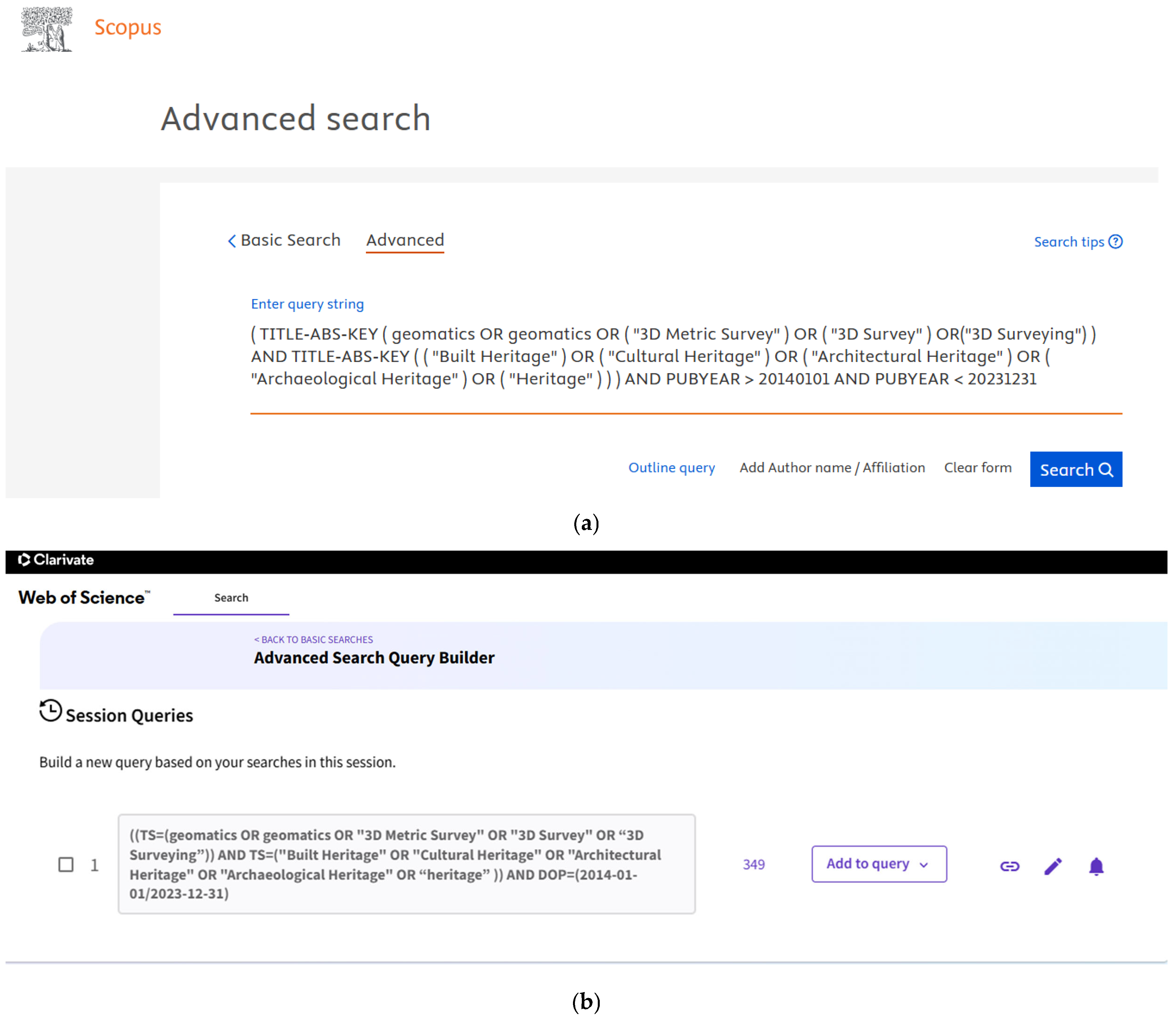
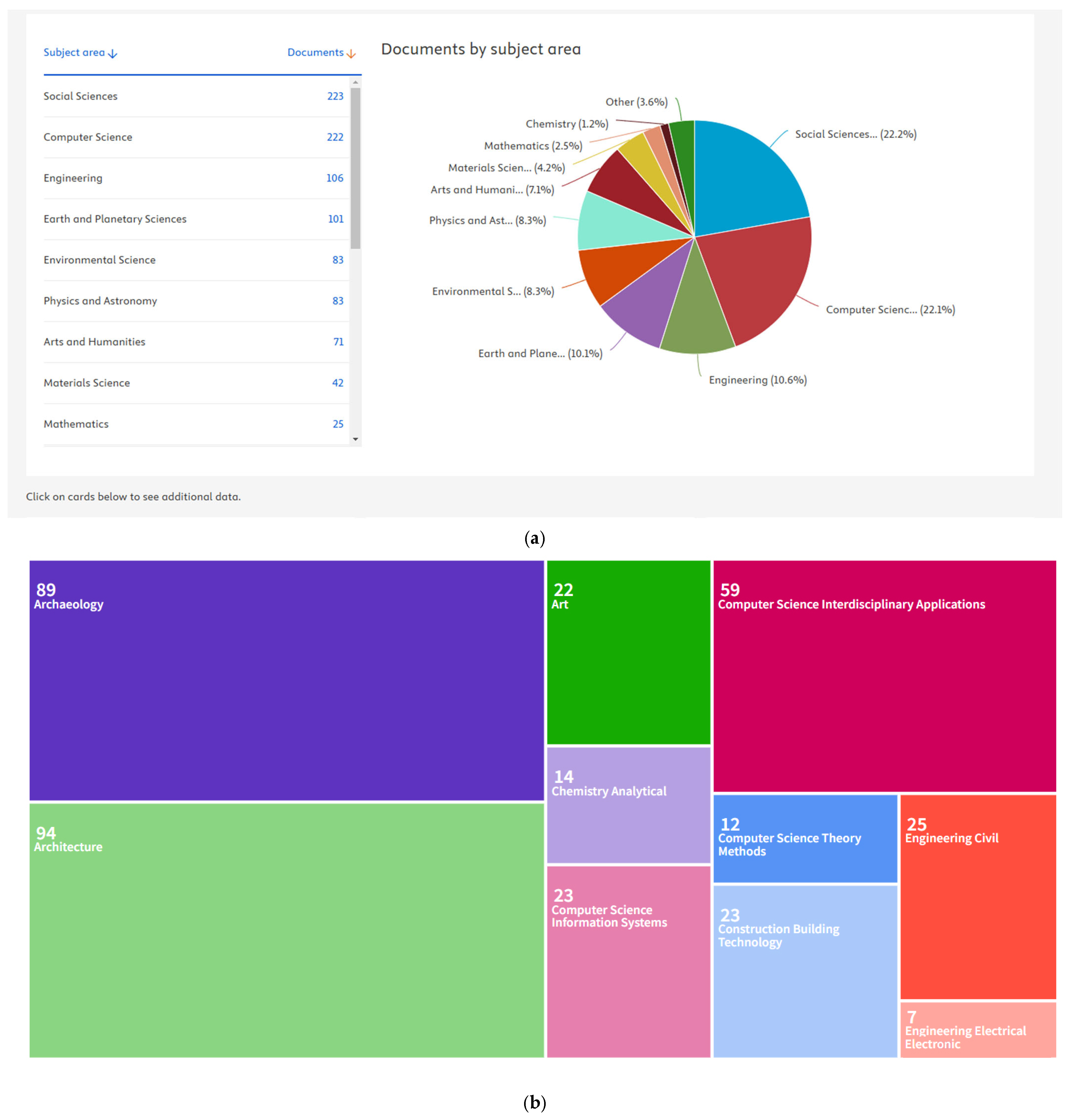

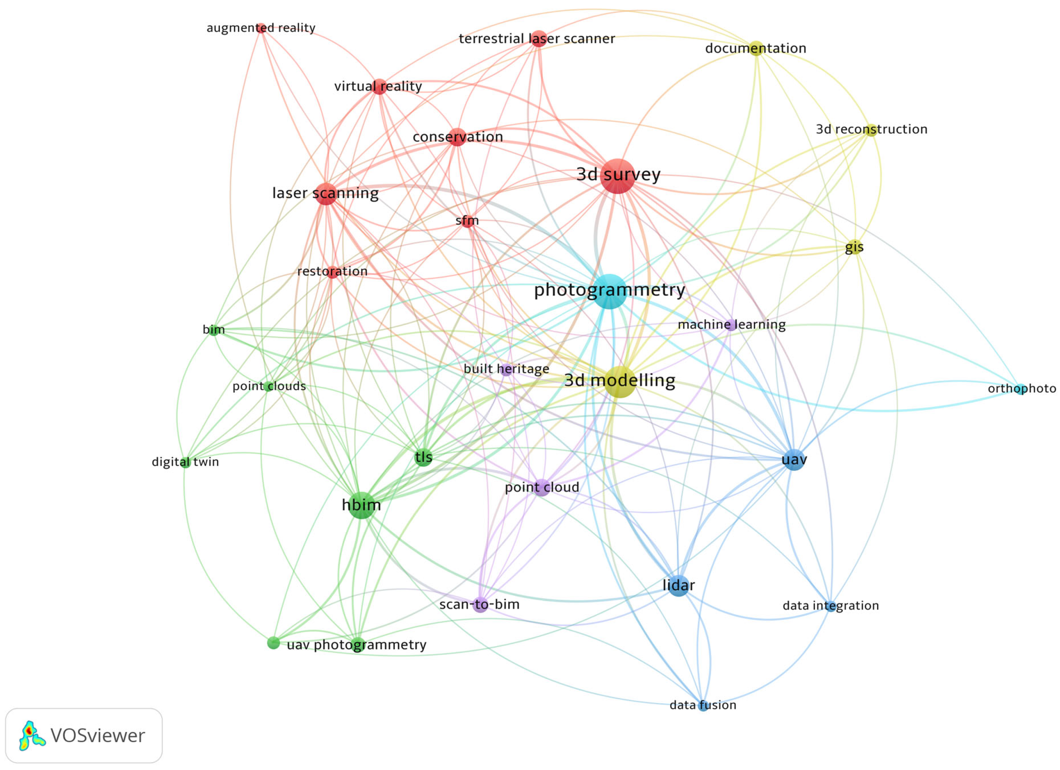
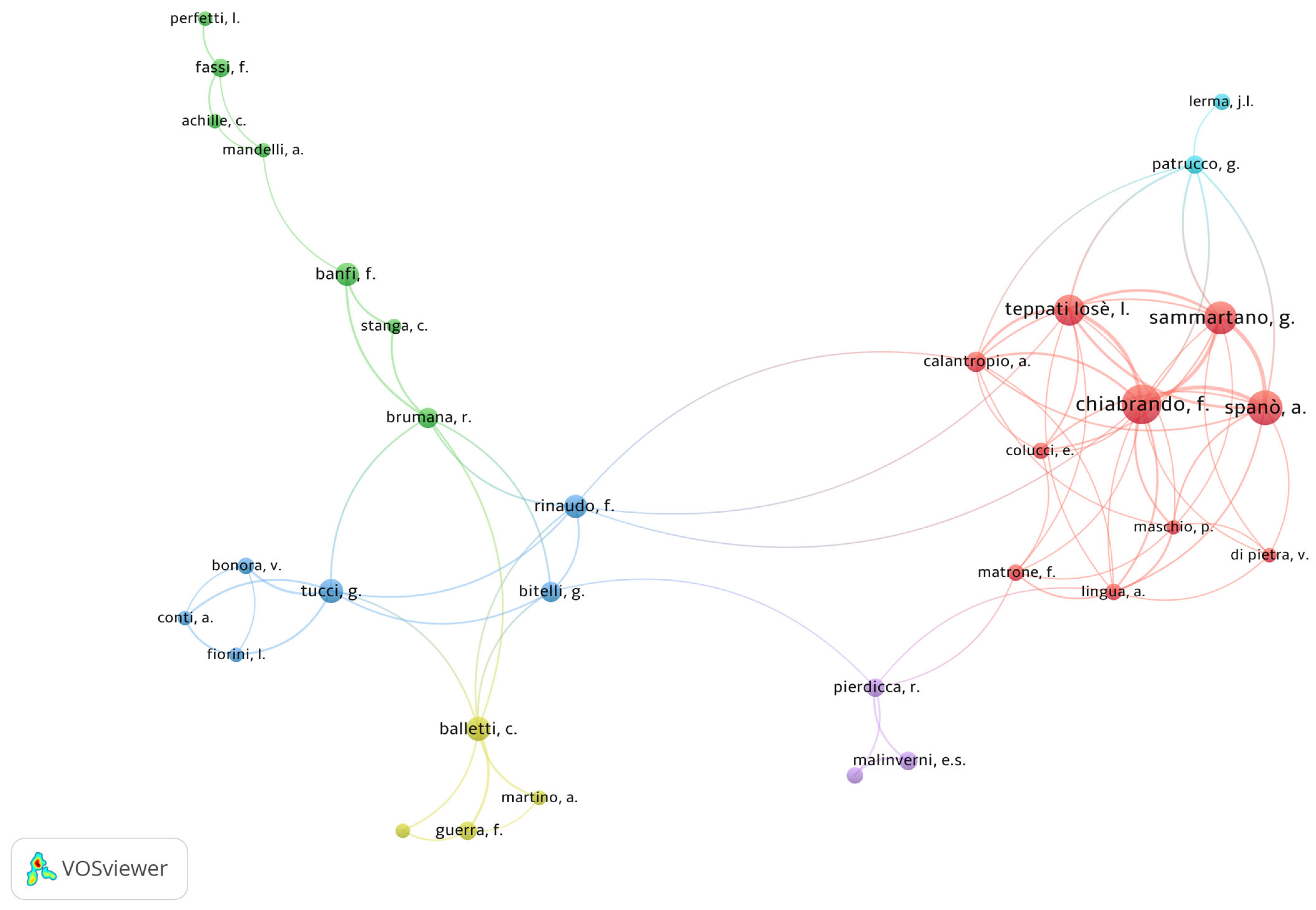
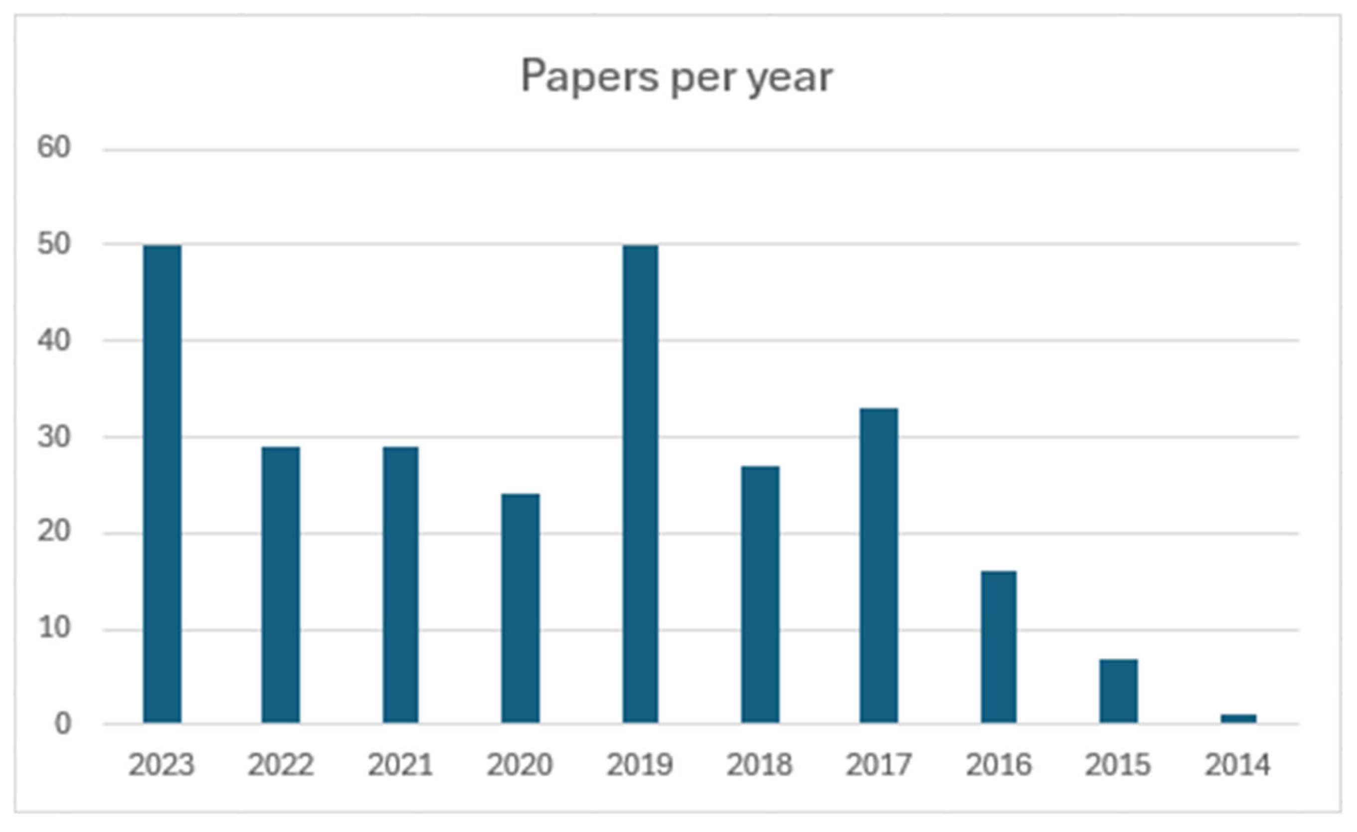
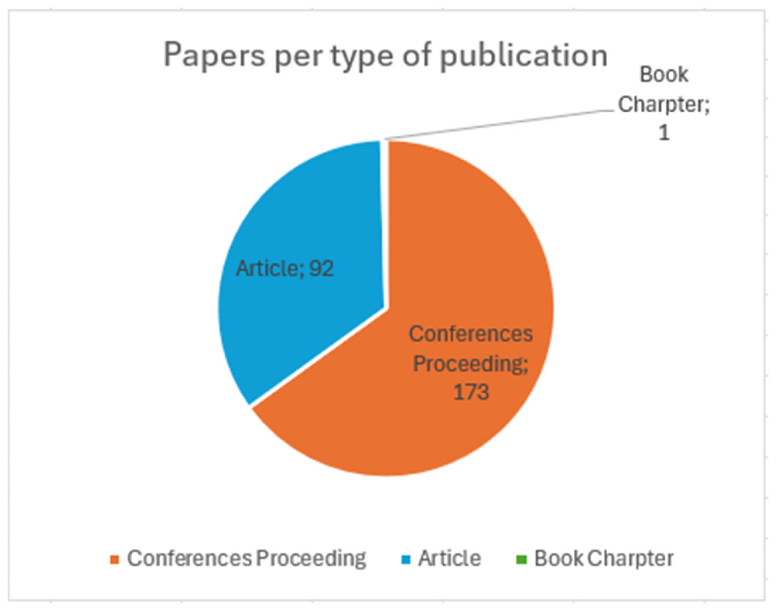
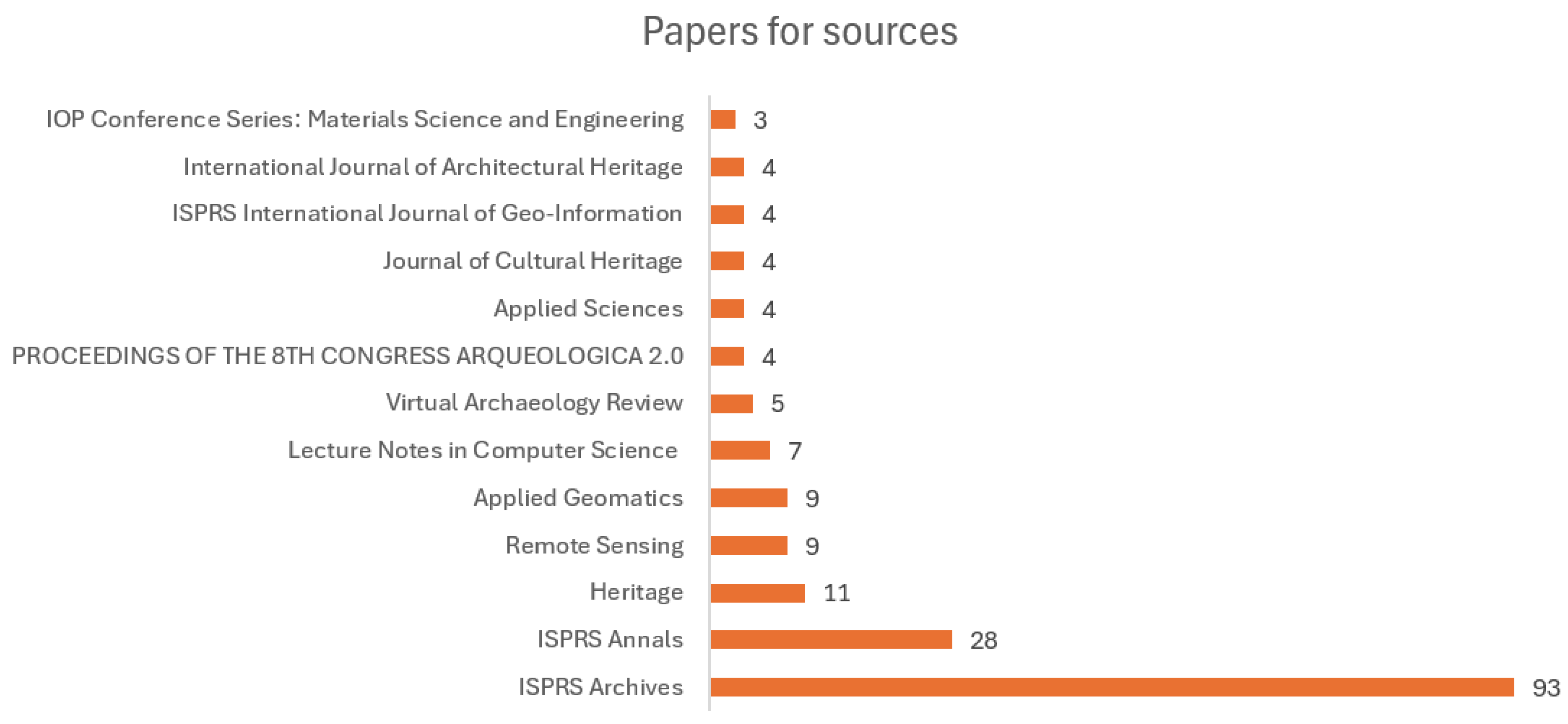
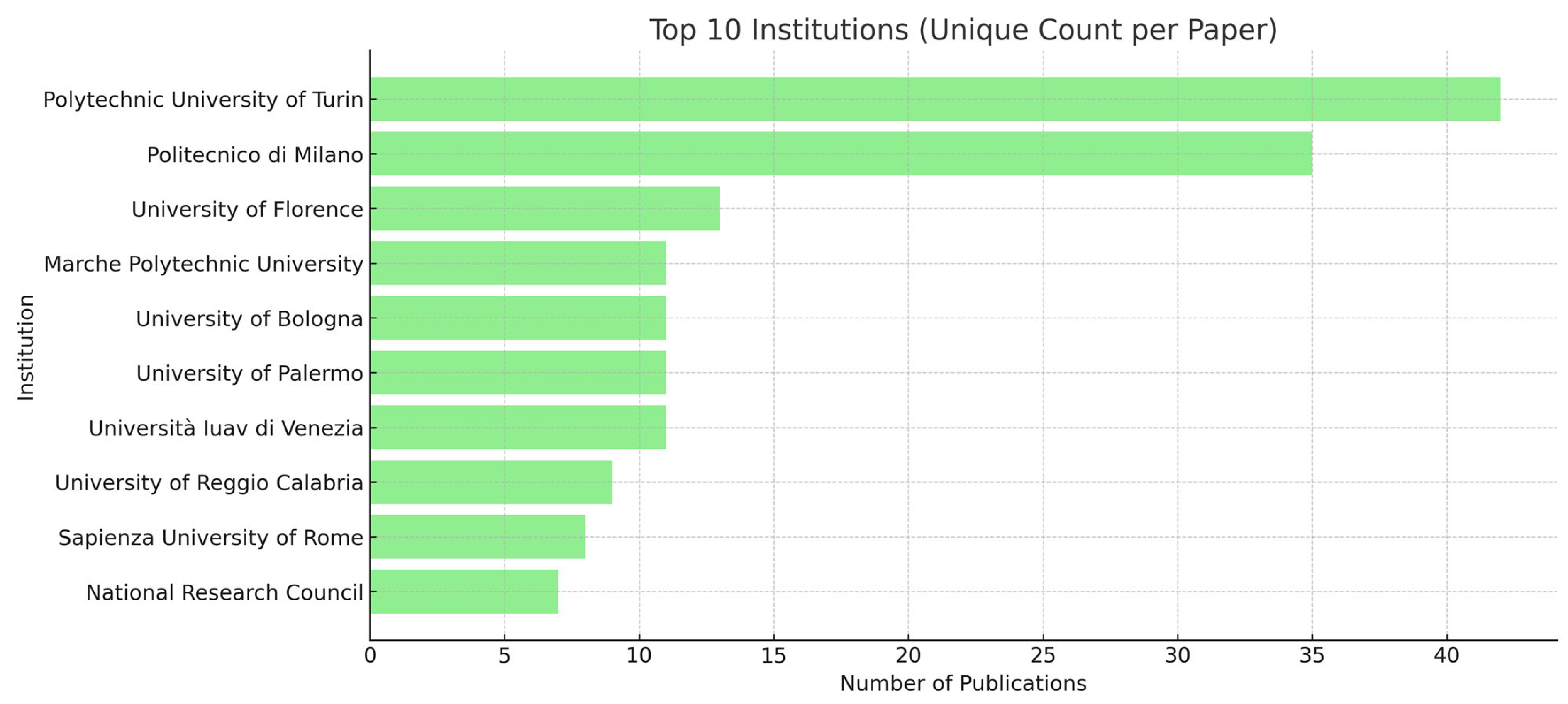

| Search Terms | ||
|---|---|---|
| Block 1 | Block 2 | |
| Terms | geomatics | built heritage |
| Synonyms and complementary words | geomatic 3d metric survey 3d survey 3d surveying | cultural heritage architectural heritage archaeological heritage heritage |
Disclaimer/Publisher’s Note: The statements, opinions and data contained in all publications are solely those of the individual author(s) and contributor(s) and not of MDPI and/or the editor(s). MDPI and/or the editor(s) disclaim responsibility for any injury to people or property resulting from any ideas, methods, instructions or products referred to in the content. |
© 2025 by the authors. Licensee MDPI, Basel, Switzerland. This article is an open access article distributed under the terms and conditions of the Creative Commons Attribution (CC BY) license (https://creativecommons.org/licenses/by/4.0/).
Share and Cite
Teppati Losè, L.; Rinaudo, F. A Systematic Literature Review to Assist in Defining New Guidelines and Practical Handbooks for the Documentation of Built Heritage. Heritage 2025, 8, 249. https://doi.org/10.3390/heritage8070249
Teppati Losè L, Rinaudo F. A Systematic Literature Review to Assist in Defining New Guidelines and Practical Handbooks for the Documentation of Built Heritage. Heritage. 2025; 8(7):249. https://doi.org/10.3390/heritage8070249
Chicago/Turabian StyleTeppati Losè, Lorenzo, and Fulvio Rinaudo. 2025. "A Systematic Literature Review to Assist in Defining New Guidelines and Practical Handbooks for the Documentation of Built Heritage" Heritage 8, no. 7: 249. https://doi.org/10.3390/heritage8070249
APA StyleTeppati Losè, L., & Rinaudo, F. (2025). A Systematic Literature Review to Assist in Defining New Guidelines and Practical Handbooks for the Documentation of Built Heritage. Heritage, 8(7), 249. https://doi.org/10.3390/heritage8070249