Abstract
This paper outlines a methodology for creating an educational and informative communication system for non-specialised audiences in order to preserve and pass on the heritage of ideas and practices adopted in the medieval political and administrative sphere. Through the combined use of digital technologies (such as GISs, 3D modelling and virtual tours), historical sources can potentially reveal how political and administrative aspects affected different areas within the medieval city, not just the main seats of power. Bologna, a prestigious medieval university metropolis, is chosen as a case study because of the remarkable wealth of documentation in its archives from the city’s political culture in the Middle Ages. Written historical sources, including documentary and narrative texts, are among the primary tools employed in the study of European medieval urban communities in general. Documentary sources help us understand and reconstruct the complexities of civic administration, urban policies and the economy, as well as how citizens experience them daily. The involvement of citizens in the political and administrative life of late medieval cities is explored through the management and digital processing of historical documentation. Digital humanities tools can facilitate this analysis, offering a perspective that sheds light on the formation of the pre-modern state. Although digital databases and repositories have significantly contributed to preserving and digitally archiving historical sources, these are often aimed exclusively at the academic level and remain underutilised as privileged didactic and educational tools for a broad audience.
1. Introduction
Late 13th-century European cities were characterised by a proliferation of diverse citizen associations. Prominent among them were the guilds that united people of the same occupation. Max Weber considered these sworn associations (coniurationes) fundamental to the emergence of Western urban life, arguing that the medieval city’s very legal identity was that of an oath-bound community—a spatially rooted association of citizens [1]. While professional guilds are extensively studied [2,3], other forms, such as neighbourhood defence groups, equally integral to the urban fabric received less attention.
Many European cities preserve large archival collections concerning the organisation of medieval community life [4,5]. The integration of digital technologies is opening up new horizons in the access, preservation and valorisation of this material, but this opportunity is mainly addressed to scholars and not yet to a wider public that could benefit instead from the democratisation of political culture.
The medieval communal towns were complex entities, with their political and administrative life characterised by a series of collegial assemblies, offices and magistracies. These institutions were responsible for regulating the functioning of the town, as well as ensuring compliance with the established rules. As municipal government underwent its various phases (consular, podestarial and popular), these political and administrative structures began to include members from diverse socioeconomic backgrounds, such as those belonging to guilds and arms societies that represented the popolo as a political body. The timeframe for public office and participation in government groups was limited to a few months, thereby ensuring, at least in principle, a certain degree of turnover. Consequently, a significant proportion of the population was encouraged to participate in both administrative and political spheres, thereby contributing substantially and in diverse forms to the functioning of municipal councils and associations [6]. This intricate participatory mechanism yielded a substantial corpus of regulatory and administrative documentation (including statutes, deeds and resolutions), a significant proportion of which remains extant in the local State Archives.
These documents serve as direct evidence of the operational functionality of municipal administrations and citizen participation. However, it is important to note that the accessibility of these documents and information is limited to a select group of experts who possess the requisite historical, palaeographical and linguistic expertise. These scholars possess the skills necessary to translate the texts, which are written in Latin, and accurately interpret their content within the context of the medieval and municipal historical eras that gave rise to them.
The numerous digitisation projects that have been implemented in recent years have, as their primary objective, the creation of repositories of high-resolution images to facilitate access for scholars. However, they seldom encompass a component intended for popularisation aimed at a more general audience. It goes without saying that certain initiatives are designed with the objective of ‘facilitated dissemination’. An example of this is the DALME project—the Documentary Archaeology of Late Medieval Europe—[7], where the archival material is presented and transcribed (albeit not translated) and the user is guided to discover the sources through specifically designed thematic paths. The DALME Project is discussed in detail below in Section 3.2.
The objective of our project is to utilise a range of digital humanities methodologies, including Geographic Information Systems (GISs) and three-dimensional (3D) graphics, as instruments to convey the intricacies of archival and documentary materials to users who lack specialised knowledge. This case study of Bologna aims in particular to establish a system, or ‘hub’, that will enable the general public to explore and comprehend the intricacies of the political and administrative knowledge of a 13th-century commune. This will be achieved by navigating the relevant sources and documents through web technologies and multimedia graphic reconstructions.
A further aspect that this work seeks to highlight is how the places of politics in communal cities are not strictly confined to the main buildings of power, such as the town hall or the central piazza, but also extend to other spaces and structures within the urban quarters (Figure 1), thus in turn fostering the involvement of a large number of citizens in the management of the city [8].
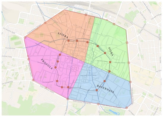
Figure 1.
The medieval four quarters of Bologna. Source: © 2025 ‘Gina Fasoli Research Centre for the History of Cities’, Department of Architecture, Alma Mater Studiorum—University of Bologna.
The acquisition and creation of 3D data through surveying and modelling for both small objects and large geographic areas has constantly evolved, making these techniques an integral part of digital humanities and Digital Heritage [9,10,11,12,13,14,15,16,17]. Similarly, online archival sources for the academic world are increasingly present on the web. However, there is still a lack of direct connection between written documentary sources and the urban space (2D and 3D) with its buildings.
Furthermore, there is a need to facilitate the understanding of such documents (written in Latin and rich in abbreviations and special signs) as well as the understanding of the producers of this documentation. These aspects have not yet been extensively explored by digital humanities projects, which are mainly focused on the creation of digital critical editions of texts [18,19,20,21].
This paper aims to fill this research gap using different digital humanities technologies (web, GISs, 3D) to contribute to the understanding and preservation of medieval written documentary sources as cultural and political heritage. After the Introduction, this paper addresses, in Section 2 (Urban spaces and Associationism), the political role of the medieval Bologna neighbourhood societies. Materials, methods and procedures are described in Section 3, which is subdivided into five subsections. Section 4 (Results) presents the capabilities of the proposed procedures and the actual findings derived from the case study. Conclusions are presented in Section 5, along with reflections on limitations and future research directions.
2. Urban Spaces and Associationism: The Political Role of the Neighbourhood Societies
The institutional and administrative organisation of a communal city in the 13th century was very complex, and citizens who had wide access to political life were required to participate in many ways and at various levels. This extensive engagement of the urban population, found in many communal regimes in medieval Italy, was also reflected in the amount of documentation produced [22], which, in the case of Bologna, has largely survived to the present day.
This article examines documentation from sworn associations, which were groups of people who bound themselves together through solemn oaths to achieve common goals, provide mutual support or assert certain rights. One example is the neighbourhood societies, particularly the arms societies (neighbourhood defence units), that were distributed evenly across Bologna’s four quarters [23].
The arms societies emerged in numerous communal towns across central and northern Italy between 1190 and 1220–1230. The political importance of these societies in Bologna is further evidenced by their capacity to elect the Anziani (members of the executive council) and to send official representatives to other Consigli di Popolo. In Bologna, they were active until the authoritarian government of the Cardinal Legate Bertrando del Poggetto (1327–1334), when there was a drastic change in the political–institutional system, with the suppression of the magistracies of the podesta and the Capitano del Popolo and precisely the dissolution of the societies of arms.
Like other communities born and organised within the communal regimes of the Popolo, the societies of arms were associations of citizens based on an oath. A pivotal element of most associative bonds and a fundamental instrument for regulating relations between people, the oath, which the individual was required to pronounce in the act of joining an association, gave body and substance to the social bond. The oath, for which the term sacrament is used, began with an invocation to the divinity. Thereafter, it assumed a contractual value that constituted the foundation of the mechanisms of public and private life [24].
In the second half of the 13th century, the members of the arms societies in Bologna included citizens residing in the same area. They were essentially groups of neighbours, but the residence factor did not guarantee membership in the arms society, for which applicants needed to have no reason for enmity with any of the members. The documentation produced by the arm societies for the 13th and 14th centuries relates to statutes, matriculae (periodical lists of members) and special legislative acts [22,24]. The association, as recalled, was based on written rules, the statutes, which through a series of rubrics regulated the organisation of community life, such as meeting occasions in which individual members were required to attend as a matter of duty.
Of the twenty-five arms societies that arose in Bologna and were evenly distributed among the four quarters into which the city was subdivided, this article focuses on the one established in the southwestern area, in the quarter Porta Procola (Figure 1). Here, the Societas Armorum Schisarum de Saragozia (Stripes of Saragozza arms society) was organised, made up of members from three adjoining parishes (cappelle): S. Cristoforo di Saragozza, S. Maria delle Muratelle and S. Caterina di Saragozza. The first statutes that have come down to us of this arms society date back to 1254 and were published by A. Gaudenzi in 1889 [25].
Though unpublished, the statutes promulgated in 1262 are worth considering. Of these, a few rubrics will be presented here that have a clear reference to the places and spaces in the society’s area and that, in some cases, have been further detailed compared to the 1254 statutes. After the invocation to God, the Virgin, St. Mary, St. Christopher and St. Catherine and all the confessors and saints, the precise reference to the values of peace (bonum et pacificum statum civitatis Bononie et populi) is highlighted, values that the communal regime had placed at the foundation of civil coexistence and did not fail to exalt in its statutes. The general structure of the statutes of the Stripes of Saragozza includes the oath of the members, various provisions describing the organigram consisting of ministrales (officials), massarius (financial manager), notary, nuntio (messenger), gonfalonerius (standard-bearer), inquisitores rationis (syndics) and sapientes (judges and jurists) as well as their duties towards the association. The duties of all members and the rules concerning events, such as the convivium (banquet) and funeral celebrations in the case of the death of a member, were also set out. The rubrics also explicitly refer to a spatial contextualisation that was missing from the 1254 statutes: the specification that the ministrales to be elected should be distributed evenly across the four morelli into which the area was divided. These morelli were those of S. Cristoforo di Saragozza, S. Maria delle Muratelle, de Medio, and S. Caterina di Saragozza, which will be discussed later. Evidently, in less than a decade, the Stripes arms society’s target population had increased, necessitating a more equitable distribution of ministrales’ shares.
Together with the guilds (societies of arts), the arms societies constituted, as already mentioned, the recruitment base for bodies directly connected to the functioning of the commune and its political structures, such as the Consiglio degli Anziani, the important executive council whose members were ‘elected by various means that changed over time, but in general by an elaborate system of cooption and nominations made by the guilds and arms societies’ [25] (p. 76). The associative dimension expressed by these societies was also further stimulated by compulsory attendance at a monthly mass, which was also an opportunity to assess the entry of new members, and an annual banquet, all activities that also served to cement a sense of belonging, which in turn served to increase effective political strategies.
3. Materials and Methods
3.1. The Evolution of Digital Historical Research: Bologna’s Innovative Approach
The research presented in this article has its roots in the activities of the PhD programme in History and Informatics, established in 1996 at the University of Bologna. In this context, on the initiative of Francesca Bocchi and Pier Ugo Calzolari, the Nu.M.E. (New Electronic Museum of the City of Bologna) project was launched, with the aim of creating a multimedia environment that would retrace the urban evolution of the city, starting from the present day and going back to the Middle Ages. The first planning phase involved specific research on documentary sources, both in terms of textual analysis and content and as constituent elements of the databases necessary for information management. At the same time, work began on the modelling and virtual navigation part. The project, which was also presented at the annual ACM SIGGRAPH conference (Los Angeles, CA, USA, 1999), led to the creation of a four-dimensional city, with the addition of the temporal dimension to the three spatial dimensions. The first implementation of Nu.M.E. was a web-based virtual environment; subsequently, an immersive virtual environment was realised at the CINECA VISIT Theatre [26,27]. The wealth of skills acquired through the activities and research of the PhD programme in History and Informatics was enhanced with the foundation in 2003 of the ‘Gina Fasoli Research Centre for the History of Cities’ where historical research, based on the analysis of numerous types of written sources, is combined with the study of urban transformations, digital cartography and virtual reconstructions of urban quarters, architecture and monuments, offering keys to interpreting the continuous relationship between cities and the communities living in them [28].
3.2. Digital Humanities and Archival Historical Sources
In the field of digital humanities applied to archival historical sources, digital technologies can play a key role in three phases:
- Acquisition of written sources through digital scanning;
- Analysis;
- Dissemination.
While digitisation, creation of repositories and content metadata for analytical and critical edition purposes play a key role in the first two, the most effective techniques for dissemination are related to visual technologies.
The acquisition phase is undoubtedly essential and necessary for all others, as shown by the proliferation of initiatives aimed at digitising the vast documentary heritage preserved in libraries and historical archives.
The most prestigious institutions worldwide, such as the British Library [29], the Bayerische Staatsbibliothek [30] (accessed on 21 May 2025) or the Vatican Library [31], have long since initiated massive digitisation programmes of their archival holdings using high-resolution photographic technologies and often setting up in-house laboratories dedicated to managing the entire process up to the publication of the sources online, such as the Munich Digitisation Centre [32]. These initiatives have also stimulated the development of open standards for the visualisation of images, such as the IIIF framework protocols for online visualisation [33], which are today adopted in most digital collections.
At the national and local level, institutions such as the Italian State Archives have also embarked on a similar approach, e.g., the Archivio di Stato di Firenze [34] or the Archivio Centrale dello Stato [35].
The outcome of these initiatives is the creation of online repositories of digital copies of historical documents, which make them accessible to scholars from all over the world while ensuring their material integrity.
As mentioned in the introduction, however, a few of these projects also include a phase aimed at communication with nonspecialists.
In some cases, such as in the DALME project—the Documentary Archaeology of Late Medieval Europe—[7], the archival collections such as estate inventories are published and transcribed (though with no translation), and the user can discover the materials through specifically designed thematic paths. The main target user of the project remains the scholar/researcher, but there is also a didactic use of the repository: Through the ‘Classroom Use’ section, themes and learning study paths are suggested for students in intermediate and advanced classes.
Similarly, within the project The Great Parchment Book of the Honourable The Irish Society [36,37,38,39], the surviving documents of the Great Parchment Book of 1639 are digitally published: this was a register of the properties in the city of Derry managed by the City of London through the Honourable The Irish Society in the context of the Protestant British colonisation of Ulster under James I (1609). Alongside the publication of the digital image of the parchments, there is both a transcription of the text and a modern language translation. This already represents a more advanced level of use, allowing anyone to read the documents. Furthermore, names of people, places and guilds are tagged within the individual parchments. The project as a whole, although not recent (dating back to 2013), maintains a clear layout even for users without specific historical training and allows anyone to relate directly to the original historical source, without impoverishing the information content.
3.3. Visual Technologies and Archival Historical Sources: Methodological Approach
As already mentioned, to further facilitate the transmission of complex content to a wide audience, it is possible to resort to the use of visual technologies (or data visualisation), through which a graphical rendering of information and concepts can be proposed. Data visualisation today makes use of many tools, which can also be effectively employed in the field of historical sciences. Among these, one of the most effective is the GIS—Geographical Information System—which, as is well known, is a system for the visualisation, management and analysis of geographical data, also used for many years in the archaeological and historical fields. In addition to its analytical functions, today it is also often used in combination with web and Digital Storytelling tools for educational purposes. WebGIS and WebApps, such as those within ESRI’s ArcGIS Online suite (2025 edition), make it possible to create interactive 2D and 3D maps that can be accessed via the web and interconnected with multimedia elements such as text, images, films or 3D objects.
Similarly, 3D graphical reconstructions of historical contexts constitute an immediate and easy-to-understand means of communication for a wide audience. Three-dimensional modelling, rendering and interactive navigation of virtual spaces not only make it possible to visually reproduce vanished historical contexts but can also be used in synergy with the visualisation of digital sources to make complex concepts, such as the political and social organisation of a 13th-century city, more accessible.
Figure 2 illustrates the procedures followed and the technologies used in the present research.
Figure 2.
Methodological workflow.
3.4. The Web Visualisation of Statutory Provisions (The Statutes of the Stripes of Saragozza)
The rubrics selected for this paper refer to ethical and, above all, behavioural rules, which were the basis of societal coexistence but fully reflect those rules found in practice in the civic statutes and applicable to the entire civic body. The first rubric considered (the third of the forty-one rubrics of the statutes) concerns the election of the ministrales, the main officials of the arms society. The second rubric (the twelfth in the sequence) refers to the compulsory monthly meeting of all members. The third rubric (the twenty-seventh in the sequence) ordered that, in times of unrest, the standard-bearer should go with the banner to the trivium of Santa Maria de Muratellis (Figure 3).
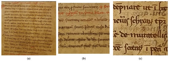
Figure 3.
Detail from the Statutes of the Stripes of Saragozza (Archivio di Stato di Bologna, Comune, Capitano del Popolo, b. IV, no. 66): rubric III (a), rubric XII (b) and rubric XXVII (c).
As a first step, a web page was created as a template for the display of the parchments relative to the statutes of the Stripes of Saragozza and, in particular, those relating to the rubrics taken into consideration for this study. The layout of the page was set up according to a three-part model, with one container dedicated to the image and two to the text (transcribed and translated) according to a 50-25-25 division of the entire width of the page: 50% of the space for the image container, 25% for the original transcription and 25% for the modern translation of the text, so as to maintain a visual balance between the sections.
The images have been rendered using the IIIF (International Image Interoperability Framework) framework, a solution that has become prevalent among cultural institutions for the purpose of web-based visualisation of historical and archival documents. We have made use of the Glycerine platform [40], which provides tools for image visualisation (Glycerine Viewer) and annotation (Glycerine Editor) according to IIIF criteria. The Glycerine Viewer can be embedded within a web page by means of a simple <iframe> tag, while the Editor allows the creation, directly on the images, of graphic annotations connected to pop-ups with text and hypertext links (Figure 4).
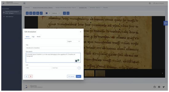
Figure 4.
The Glycerine.io framework: creating an annotation on the rubric image.
To this end, the references linked to the topographical indications of the rubrics, such as the morello of S. Cristoforo of Saragozza, the morello of S. Maria delle Muratelle, the morello ‘de Medio’ and the morello of S. Caterina di Saragozza, were noted. These were subsequently highlighted in the transcription and translation. Finally, links to the following topographical views on WebGIS have been added.
3.5. Visualising Medieval Urban Space
The spatial references cited in the rubrics of the Stripes of Saragozza statutes are not in themselves sufficient to understand the organisation of urban space in the area of via Saragozza. Of the three churches mentioned in the 13th-century document (S. Cristoforo di Saragozza, S. Maria delle Muratelle and S. Caterina di Saragozza), one no longer exists, another has been demolished and rebuilt in a different position, while the last has changed orientation. S. Cristoforo di Saragozza was in fact demolished in the 15th century to allow the construction of the large Corpus Domini monastery complex. The church of S. Maria delle Muratelle was pulled down in the first half of the 17th century because it was an obstacle to the widening of Saragozza Street; it was later rebuilt in a backward position in line with the new street layout. S. Caterina di Saragozza, on the other hand, is still in its original position, although its appearance today has changed entirely, as has its orientation: The original church was in fact arranged according to the ancient liturgical direction, with the main entrance facing westwards on the then via Pizzamorti (today’s S. Caterina Street). In addition to this, it should be added that the urban fabric around these churches has also undergone profound alterations over the centuries: Buildings that today are important urban features, such as the renowned Collegio di Spagna, or entire sections of street such as today’s Via Urbana, were not even present in the mid-13th century when the Stripes of Saragozza arms society was active in this part of the city. This is why we decided to visually transpose the topographical references of the source through the setting up of a historical GIS in order to recreate the urban space of 13th-century Bologna.
As a first step, we set up two parallel maps that can also be used three-dimensionally: one relating to 13th-century Bologna and a second relating to the present-day city. This allows the user to make a direct comparison between the two time frames and visualise the places described in the source and the changes that have taken place over the centuries in this area of Bologna. The basis for both maps was a topographic coverage, including hill shading, which is part of the basic functionality of the software used, ESRI’s ArcGIS Pro 3.5.1. The map of today’s Bologna was mainly characterised by a data layer with the 1:2000 scale restitution of all the buildings present in the Municipal Technical Map of Bologna with the addition of the elevation values for each building. The dataset is freely downloadable from the Open Data portal of the Municipality of Bologna [41] and reusable under the Creative Commons CC BY 4.0 licence. The presence of the elevation values allowed the three-dimensional visualisation, obtained through extrusion, of the heights of the buildings throughout the city.
From this layer, the buildings that now correspond to the places mentioned in the headings examined were then highlighted:
- The parish of S. Caterina di Saragozza;
- The parish of S. Maria delle Muratelle;
- The parish of S. Cristoforo di Saragozza;
- The trivium (junction of three streets) of S. Maria delle Muratelle.
In order to allow even those less familiar with the city to orient themselves more easily, we have also highlighted Bologna’s most famous landmarks, i.e., those landmarks that characterise its appearance and make it immediately recognisable. Through a search of the main Italian and foreign tourist and information portals, it emerged that the city’s best-known landmarks are the Two Towers, Asinelli and Garisenda, in Piazza di Porta Ravegnana and the area of Piazza Maggiore, which is also overlooked by the buildings that have been symbols of the communal regime since the 13th century. The cathedral of St. Peter was also added for completeness. All these places were already extant and frequented during the 13th century and, albeit with changes in appearance, they still are today, making them perfect references for orientation in the urban topography of Bologna (Figure 5).
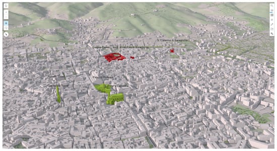
Figure 5.
The 3D map of Bologna today: general buildings are in light grey; landmarks are in green; buildings in the study area are shown in red. Source: © 2025 ‘Gina Fasoli Research Centre for the History of Cities’, Department of Architecture, Alma Mater Studiorum—University of Bologna.
In the second map, as previously mentioned, the data layers characterising the medieval urban elements have been displayed. Thanks to GIS processing resulting from the research on historical urban topography carried out by the ‘Gina Fasoli Research Centre for the History of Cities’, it was possible to reuse georeferenced vector layers, spatially accurate and characterising crucial elements of 13-century Bologna [42]. This aspect is twice as important: firstly, because it makes it possible to reuse data elaborated from historical sources and scientifically validated. Secondly, the reuse of scientific processing of historical data, made possible by the interoperability of the vector shapefile format, guarantees a transmission of knowledge that is often challenged by the rapid technological obsolescence affecting digital data. Being able to access and reuse decades-old datasets that are the result of often long and complex research, is indeed one of the biggest challenges of the digital humanities.
The following spatially validated layers were used to characterise the 13th-century map of Bologna (Figure 6):
- The perimeter of the second ring of walls (Torresotti walls): Derived from a study on the 13-century survey of urban spaces [43], this layer not only shows the layout of the city walls but also shows the other elements related to the walls, which made up the defensive circuit:
- ○
- The street inside the walls;
- ○
- The walls;
- ○
- The moat outside the walls;
- ○
- The street outside the walls.
- The gates, or Serragli, of the second ring of walls (the positions of these elements are known, the demolition of most of them took place even centuries after the Torresotti walls were landed, and four of them are still present today);
- The medieval parishes, or cappelle. The identification and positioning of the cappelle is also the result of an in-depth study of the medieval Bolognese estimi [44];
- The street layout, limited to the extension inside the Torresotti walls and devoid of the modifications that have occurred since the modern age;
- The perimeter and area of the individual plots, obtained from an analysis of the oldest cartographic representation of the city: the Pianta Prospettica della Città di Bologna, a bird’s eye view of 1575 kept in the Vatican’s apostolic palaces [45] (Figure 7).
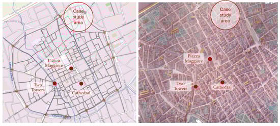 Figure 7. The GIS of medieval Bologna with late medieval urban plots (left) derived from the Pianta Prospettica della Città di Bologna (right). The webmap is oriented according to the Pianta Prospettica.

Figure 6.
The GIS of 13th-century Bologna with Torresotti walls, parishes (cappelle), streams and canals. The highlighted cappelle are those considered in the study. Source: © 2025 ‘Gina Fasoli Research Centre for the History of Cities’, Alma Mater Studiorum—University of Bologna.
Figure 6.
The GIS of 13th-century Bologna with Torresotti walls, parishes (cappelle), streams and canals. The highlighted cappelle are those considered in the study. Source: © 2025 ‘Gina Fasoli Research Centre for the History of Cities’, Alma Mater Studiorum—University of Bologna.

Once the map was set up with these layers, we focused on adding topographical references that could be deduced from the rubrics of the statutes. In the first rubric analysed, for example, it is established that, in the election of the 8 ministrales, 2 must come from the area (morello) of S. Cristoforo di Saragozza, 2 from the area (morello) of S. Maria delle Muratelle, 2 from the ‘middle’ area (morello de medio) and 2 from the area (morello) of S. Caterina di Saragozza.
If the position of the aforementioned cappelle was easily highlighted by filtering the data already present in the historical GIS in the layer of medieval cappelle, the graphic definition of a hypothetical extension of the areas (morelli) referable to each of the 3 cappelle proved less simple. The definition of the extension of the morelli has been the most challenging phase since we lack precise topographical points. Even more complex was the determination of the area described in the document simply as ‘morello de Medio’, an area that must certainly have been familiar to the members of the Stripes of Saragozza but which has lost all topographical clues for us today. In delimiting these areas, the study of coeval sources has provided useful insights, although the historian’s critical interpretation remains an indispensable tool for the correct interpretation of information. For the graphic rendering of the area of each morello, we created a polygon with the reference cappella as its radiating point and the space of the adjacent cappella as its north, east and west limits, following the network of streets and the layout of the blocks. For the southern boundary, on the other hand, we did not stop at the line of the walls since, as the source itself shows, the area of the chapels also included the boroughs outside the walls but proceeded as far as the outermost wall (Circla).
Instead, the space between the morelli of S. Maria delle Muratelle and S. Caterina di Saragozza was interpreted as the morello de Medio, maintaining the same criterion described above to delimit its boundaries.
As a final element, 3D models of buildings were inserted and highlighted in a similar way to what has already been set up for today’s map. For the visualisation of the medieval city, the spatial landmarks of the Asinelli and Garisenda towers (known as Two Towers), the Piazza Maggiore and St. Peter’s Cathedral were also shown to provide useful orientation points when comparing the two maps (Figure 8).
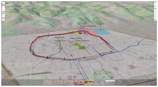
Figure 8.
The 3D map of 13th-century Bologna with the topographical features mentioned in the rubrics of the Stripes of Saragozza’s Statutes. Source: © 2025 ‘Gina Fasoli Research Centre for the History of Cities’, Department of Architecture, Alma Mater Studiorum—University of Bologna.
While the 3D buildings of contemporary Bologna were created all together in an automated manner in ArcGIS Pro by means of extrusion using the value of the altimetric height recorded in the shapefile’s attribute table for each building (see above), the reconstruction of the 3D models of the medieval buildings was performed manually one by one and in detail starting from historical references (such as the aforementioned Pianta Prospettica) and through the use of the specific professional 3D modelling software Blender 4.0.2 (Figure 9 and Figure 10).
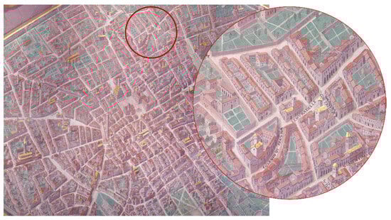
Figure 9.
Pianta Prospettica della Città di Bologna (detail) with a zoom on the area around the church of S. Maria delle Muratelle.
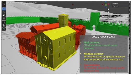
Figure 10.
3D modelling of the buildings forming the urban plot of S. Maria delle Muratelle within the Torresotti walls.
From Blender, they were then individually exported in fbx format, imported into ArcGIS Pro as individual 3D Objects and manually georeferenced in the respective locations, as evidenced by the previous historical studies.
Despite the recent evolution of AI techniques also in the field of 3D modelling [46], the specific reference to historical architectures and the presence of even direct pictorial references pointed towards a more canonical 3D modelling procedure.
Particular attention was paid to the three-dimensional modelling of the cappelle of S. Cristoforo di Saragozza, S. Maria delle Muratelle and S. Caterina di Saragozza, as they must have appeared in the 13th century. For this purpose, the cappelle were recreated using Blender according to specific visual references, such as the aforementioned Pianta Prospettica della Città di Bologna or to coeval buildings, still extant even though only partially, such as the façade of the 13th-century cappella of S. Matteo degli Accarisi. The 3D models of the churches were then included in the 13th-century map. The GIS maps, including all the elements described above, were uploaded to ESRI’s ArcGIS Online portal [47]. They were then published online as WebGIS through specific tools, such as the MapViewer for two-dimensional visualisation and the SceneViewer for rendering 3D scenes (Figure 11).
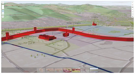
Figure 11.
The 3D map of 13th-century Bologna: detail of the trivium. Source: © 2025 ‘Gina Fasoli Research Centre for the History of Cities’, Department of Architecture, Alma Mater Studiorum—University of Bologna.
The two WebScenes are then integrated within an ArcGIS Online Dashboard to allow their reciprocal movements to be linked so that the user exploring one of the two urban landscapes can maintain the same orientation, point of view and zoom level in the other as well, to facilitate the comparison of the same places (the Via Saragozza crossroads) in space and time (Figure 12). The Dashboard is eventually embedded in the web page by exporting from ArcGIS Online through an iframe code.
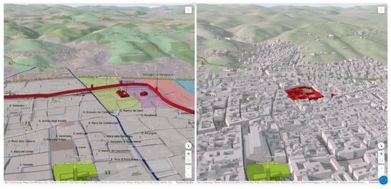
Figure 12.
Three-dimensional dashboard showing the two web scenes side by side: the visualisation of medieval Bologna (left) and nowadays Bologna (right).
4. Results
The result of the procedure described above is an online system that, starting from a simple web page, enables all kinds of users, including those without a specific cultural or historical background, to understand the content of a historical source.
Unlike the typical approach of web repositories and digital editions of sources (which use the digital humanities mainly in the academic world for the digital reproduction of the document and its philological interpretations), the approach proposed here has seen the combined use of visual technologies typical of the digital humanities aimed above all at the content of the archival source and for didactic and dissemination purposes.
The user enters directly into the web page where he/she finds a first level of access to the archival document: Through the IIIF viewer, he/she can view in detail the digital image of the original parchments kept at the State Archives of Bologna; furthermore, an accordion layout presents the Latin transcription of the text, maintaining the division into lines of the source, as well as the transcription in modern language. This allows even a user without any palaeographic or classical linguistic training to read the content of the statutory rubrics and discover how this Bolognese society of arms was structured internally.
A second, thematic level of information is related to the indications of 13th-century urban space contained in the text of the rubrics. The topographical references are highlighted with graphic annotations (in the IIIF viewer) or hyperlinks (in the transcription and translation sections) and displayed in the lower part of the page layout. Here, through an interactive dashboard, the graphic visualisation of the urban space described in the rubrics is integrated. Through two 3D maps (or WebScene), the user can interactively navigate the urban space, comparing the current state with the 13th-century scenario mentioned in the statutes. The two maps are constrained in their movement and scale, allowing the user to move, zoom and rotate independently in each of the two layouts while maintaining the same viewpoint and orientation in the other (Figure 13).
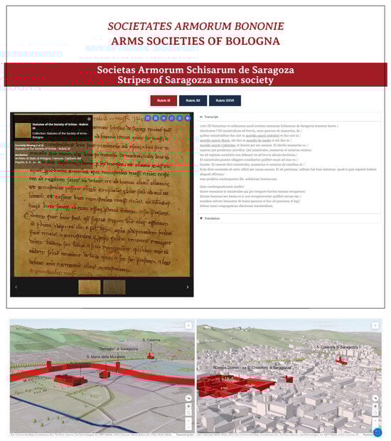
Figure 13.
The web layout showing the written sources (top left), transcription and translation (top right) and the 3D maps (left and right bottom).
The direct visual comparison between the maps makes it possible to grasp aspects of urban space that are not obvious from reading the text alone nor from simply transposing the places mentioned onto contemporary topography. The first and most evident sign is the three-dimensional rendering of the Torresotti walls, which highlights the division between urban and extra-urban space. One can also clearly see how the areas (the morelli) mentioned in the rubrics extend both inside the city (the morello of S. Cristoforo and S. Maria delle Muratelle) as well as in the outer suburbs, such as the morello of S. Caterina and, according to our interpretation, the morello de medio. A further crucial aspect is related to the arrangement of the blocks and streets around the crossroads (trivium) in front of the church of S. Maria delle Muratelle. By comparing the two maps, the user can see how Saragozza street, in the 13th century and until the mid-16th century, ended right at the aforementioned trivium or a little beyond, characterising it even more as a nerve centre and symbolic point in times of unrest. The opening of the current Via Urbana (completed in 1630) and the consequent lengthening of Via Saragozza would cut through the blocks that opened up from this point eastwards. Similarly, it is clear that the cappella di S. Maria delle Muratelle was also in a more forward position than it is today; it too would be pulled down and rebuilt in a more backward position. The analysis of these rubrics of the statutes of the Stripes of Saragozza arms society and their spatial references shows that a medieval city was organised in a precise and complex way, even in less central areas, precisely because of the active and associative involvement of its inhabitants [48].
5. Conclusions
In conclusion, the numerous documentary sources that have thankfully survived to the present day and have been carefully kept in local and national archives constitute an enormous wealth of information on the life and complex functioning mechanisms of cities in the Middle Ages.
To date, major technological developments have sped up the basic stages of digitisation and study, thus facilitating their dissemination, especially in the academic world. However, this documentary heritage also has a very strong informative and educational potential, which can also be of great interest to the general public if it is communicated through appropriate digital educational tools. The case study presented here demonstrates an effective integration of established methods of source study and published transcriptions along with the most evolved data visualisation techniques. This model can be scaled to all other medieval cities keeping archival collections, in particular, related to guilds, societal bodies and the organisation of community life in general.
A limitation of the presented methodology is related to the fact that the workflow is scalable to other European cases (using the same software in the same sequence), but the pipeline cannot be fully automated, especially in the phases related to transcription and translation of textual content.
Despite the limitations of the lack of fully automated processes for some of the project phases, the integration of archival research and digital humanities represents a challenging opportunity that the wealth of written sources from many medieval European cities invites us to pursue. Moreover, the present project of Public Humanities, focusing on the fusion of historical scholarship with digital tools (IIIF, WebGIS, ArcGIS Online and Blender) represents an opportunity to pass on to a broader audience beyond the confines of the academic world the political culture of the Middle Ages that fostered the formation of the pre-modern state.
Author Contributions
Conceptualization, R.S.; methodology, R.S. and M.O.; software, M.O.; validation, R.S. and M.O.; formal analysis, R.S. and M.O.; investigation, R.S. and M.O.; resources, R.S. and M.O.; data curation, R.S. and M.O.; writing—original draft preparation, R.S. and M.O.; writing—review and editing, R.S. and M.O.; visualization, M.O.; supervision, R.S.; project administration, R.S.; funding acquisition, R.S. All authors have read and agreed to the published version of the manuscript.
Funding
This research was partially funded by the University of Bologna.
Data Availability Statement
The data that support the findings of this study are available from the corresponding author upon reasonable request.
Conflicts of Interest
The authors declare no conflict of interest.
References
- Weber, M. Economy and Society: An Outline of Interpretive Sociology; University of California Press: Oakland, CA, USA, 1978; ISBN 978-0-520-03500-3. [Google Scholar]
- Farr, J.R. Artisans in Europe, 1300–1914; Cambridge University Press: Cambridge, UK, 2000; ISBN 978-0-521-42934-4. [Google Scholar]
- van Steensel, A. Guilds and Politics in Medieval Urban Europe. Towards a Comparative Institutional Analysis. In Craftsmen and Guilds in the Medieval and Early Modern Periods; Franz Steiner Verlag: Stuttgart, Germany, 2016; pp. 37–56. [Google Scholar]
- Keene, D.J. English h Urban Guilds, c.900-1300: The Purposes and Politics of Association. In Guilds and association in Europe, 900-1900; Institute of Historical Research: London, UK, 2006; pp. 3–26. [Google Scholar]
- Laumonier, L. Guilds and Urban Governance: Montpellier, c. 1350–1530. J. Mediev. Hist. 2025, 51, 368–388. [Google Scholar] [CrossRef]
- Blanshei, S.R. Politics and Justice in Late Medieval Bologna; Brill Academic Publishing: Leiden, The Netherlands, 2010. [Google Scholar]
- DALME. Available online: https://dalme.org/ (accessed on 23 May 2025).
- Tamba, G. Consigli Elettorali Degli Ufficiali Del Comune Bolognese Alla Fine Del Secolo XIII. Rassegna Degli Arch. Stato 1982, 42, 34–95. [Google Scholar]
- Münster, S.; Maiwald, F.; Bruschke, J.; Kröber, C.; Sun, Y.; Dworak, D.; Komorowicz, D.; Munir, I.; Beck, C.; Münster, D.L. A Digital 4D Information System on the World Scale: Research Challenges, Approaches, and Preliminary Results. Appl. Sci. 2024, 14, 1992. [Google Scholar] [CrossRef]
- Apollonio, F.I.; Fallavollita, F.; Foschi, R.; Smurra, R. Multi-Feature Uncertainty Analysis for Urban-Scale Hypothetical 3D Reconstructions: Piazza Delle Erbe Case Study. Heritage 2024, 7, 476–498. [Google Scholar] [CrossRef]
- Baik, A. A Comprehensive Heritage BIM Methodology for Digital Modelling and Conservation of Built Heritage: Application to Ghiqa Historical Market, Saudi Arabia. Remote Sens. 2024, 16, 2833. [Google Scholar] [CrossRef]
- Spreafico, A.; Chiabrando, F. 3D WebGIS for Ephemeral Architecture Documentation and Studies in the Humanities. Heritage 2024, 7, 913–947. [Google Scholar] [CrossRef]
- Long, L.; Gan, Z.; Liu, Z.; Zhao, B.; Li, Q. MSD-Det: Masonry Structures Damage Detection Dataset for Preventive Conservation of Heritage. J. Cult. Herit. 2025, 73, 358–370. [Google Scholar] [CrossRef]
- Calin, M.; Damian, G.; Popescu, T.; Manea, R.; Erghelegiu, B.; Salagean, T. 3D Modeling for Digital Preservation of Romanian Heritage Monuments. Agric. Agric. Sci. Procedia 2015, 6, 421–428. [Google Scholar] [CrossRef][Green Version]
- Li, Q.; Yang, G.; Gao, C.; Huang, Y.; Zhang, J.; Huang, D.; Zhao, B.; Chen, X.; Chen, B.M. Single Drone-Based 3D Reconstruction Approach to Improve Public Engagement in Conservation of Heritage Buildings: A Case of Hakka Tulou. J. Build. Eng. 2024, 87, 108954. [Google Scholar] [CrossRef]
- Smith, M.; Walford, N.S.; Jimenez-Bescos, C. Using 3D Modelling and Game Engine Technologies for Interactive Exploration of Cultural Heritage: An Evaluation of Four Game Engines in Relation to Roman Archaeological Heritage. Digit. Appl. Archaeol. Cult. Herit. 2019, 14, e00113. [Google Scholar] [CrossRef]
- Nishanbaev, I. A Web Repository for Geo-Located 3D Digital Cultural Heritage Models. Digit. Appl. Archaeol. Cult. Herit. 2020, 16, e00139. [Google Scholar] [CrossRef]
- Cappellotto, A. From Codex to Apps: The Medieval Manuscript in the Age of Its Digital Reproduction. Um. Digit. 2020, 4, 1–18. [Google Scholar] [CrossRef]
- Cappellotto, A. Digital Scholarly Editing and Text Reconstruction: Theoretical Perspectives and Practical Approaches. In Digital Philology: New Thoughts on Old Questions; Libreria Universitaria: Limena, Italy, 2018; pp. 77–98. ISBN 978-88-6292-982-0. [Google Scholar]
- Jaillant, L.; Rees, A. Applying AI to Digital Archives: Trust, Collaboration and Shared Professional Ethics. Digit. Scholarsh. Humanit. 2023, 38, 571–585. [Google Scholar] [CrossRef]
- Shillingsburg, P. Development Principles for Virtual Archives and Editions. Cent. Textual Stud. Digit. Humanit. Publ. 2013, 11, 2–13. [Google Scholar]
- Cammarosano, P. Italia Medievale: Struttura e Geografia Delle Fonti Scritte; La Nuova Italia Scientifica: Rome, Italy, 1991. [Google Scholar]
- Fasoli, G. Le Compagnie Delle Armi a Bologna. L’Archiginnasio 1933, XXVIII, 158–183; 323–340. [Google Scholar]
- Agamben, G. Il Sacramento del Linguaggio: Archeologia del Giuramento (Homo sacer 2, 3); GLF Editori Laterza: Rome, Italy, 2008; ISBN 978-88-420-8781-6. [Google Scholar]
- Gaudenzi, A. Statuti Delle Società Del Popolo Di Bologna; Istituto Storico Italiano: Rome, Italy, 1889; Volume 1, ISBN 1-390-68002-9. [Google Scholar]
- Bocchi, F.; Elena, B.; Manuela, G.; Rosa, S.; Fernando, L. The 4D Virtual Museum of the City of Bologna, Italy. In Proceedings of the ACM SIGGRAPH 99 Conference Abstracts and Applications, Los Angeles, CA, USA, 8–13 August 1999; Association for Computing Machinery: New York, NY, USA; 1999; pp. 8–11. [Google Scholar]
- Bocchi, F. The City in Four Dimensions: The Nu.M.E. Project. J. Digit. Inf. Manag. 2004, 2, 161–163. [Google Scholar]
- Progetti. Available online: https://centri.unibo.it/fasoli-storia-citta/it/progetti (accessed on 11 June 2025).
- Digitised Manuscripts. Available online: https://www.bl.uk/research/digitised-manuscripts/ (accessed on 23 May 2025).
- Digital Collections. Available online: https://www.bsb-muenchen.de/en/competence-centers-and-state-wide-services/competence-centers/manuscript-center/digital-collections/ (accessed on 23 May 2025).
- DigiVatLib. Available online: https://digi.vatlib.it/ (accessed on 23 May 2025).
- Munich Digitization Center (MDZ)—Homepage. Available online: https://www.digitale-sammlungen.de/en (accessed on 23 May 2025).
- IIIF Community Calendar (Eastern Time). Available online: https://calendar.google.com/calendar/u/0/embed?title=IIIF+Community+Calendar+(Eastern+Time)&showPrint=0&height=600&wkst=1&bgcolor=%23ffffff&src=1hnm5h86n94ore0vnoo188ter8@group.calendar.google.com&color=%23865A5A&ctz=America/New_York (accessed on 23 May 2025).
- Archivi Digitalizzati. Available online: https://archiviodistatofirenze.cultura.gov.it/asfi/archivi-digitalizzati (accessed on 23 May 2025).
- Archivio Centrale Dello Stato—Il Portale Delle Collezioni Digitalizzate. Available online: https://tecadigitaleacs.cultura.gov.it/ (accessed on 23 May 2025).
- Stefani, C.D.; Smither, R.; Campagnolo, A. The Great Parchment Book; London Metropolitan Archives: London, UK, 2013. [Google Scholar]
- Pal, K.; Terras, M.; Weyrich, T. 3D Reconstruction for Damaged Documents: Imaging of the Great Parchment Book. In Proceedings of the 2nd International Workshop on Historical Document Imaging and Processing, Washington DC, USA, 24 August 2013; ACM: New York, NY, USA, 2013; pp. 14–21. [Google Scholar]
- Avery, N.; Campagnolo, A.; De Stefani, C.; Pal, K.; Payne, M.; Smith, P.; Smither, R.; Stewart, E.; Stewart, P.; Stewart, A.; et al. Great Parchment Book Project Journal of Digital Humanities. J. Digit. Humanit. 2014, 3, 83–86. [Google Scholar]
- Stefani, C.D.; Smith, P. The Great Parchment Book Project. In Book Conservation and Digitization: The Challenges of Dialogue and Collaboration; Campagnolo, A., Ed.; Amsterdam University Press: Amsterdam, The Netherlands, 2020; pp. 145–156. ISBN 978-1-64189-054-0. [Google Scholar]
- Glycerine. Available online: https://glycerine.io/ (accessed on 23 May 2025).
- Home—Comune Di Bologna. Available online: https://opendata.comune.bologna.it/pages/home/ (accessed on 23 May 2025).
- Smurra, R. Spatial Order and City Authorities in Thirteenth-Century Bologna. In Protagonists of Urban Order from the Middle Ages to the Present. Actions. Ideas, Concepts; Amsterdam University Press: Amsterdam, The Netherlands, 2025; pp. 105–114. ISBN 978-90-485-5951-0. [Google Scholar]
- Lugli, F. Liber Terminorum: Ricostruzione Del Tracciato Della Cerchia Dei Torresotti. In Il Duecento; Grafis: Bologna, Italy, 1995; Volume 2, pp. 106–114. [Google Scholar]
- Smurra, R. Città, Cittadini e Imposta Diretta a Bologna Alla Fine Del Duecento: Ricerche Preliminari; CLUEB: Bologna, Italy, 2007; ISBN 978-88-491-2974-8. [Google Scholar]
- Orlandi, M. La Ricostruzione 3D Di Bologna Nel XVI Secolo: La Mappa Vaticana. In La Storia Della Città per il Museo Virtuale di Bologna—Un Decennio di Ricerche nel Dottorato di Storia e Informatica; Bononia University Press: Bologna, Italy, 2010; pp. 233–246. [Google Scholar]
- Li, Q.; Yang, G.; Bian, C.; Long, L.; Wang, X.; Gao, C.; Wong, C.L.; Huang, Y.; Zhao, B.; Chen, X.; et al. Autonomous Design Framework for Deploying Building Integrated Photovoltaics. Appl. Energy 2025, 377, 124760. [Google Scholar] [CrossRef]
- Accesso Di Accesso—ArcGIS Online. Available online: https://www.arcgis.com/index.html (accessed on 23 May 2025).
- Smurra, R.; Bocchi, F. Medieval Bologna. In Oxford Bibliographies in Medieval Studies; Oxford University Press: New York, NY, USA, 2022; pp. 1–30. [Google Scholar]


Disclaimer/Publisher’s Note: The statements, opinions and data contained in all publications are solely those of the individual author(s) and contributor(s) and not of MDPI and/or the editor(s). MDPI and/or the editor(s) disclaim responsibility for any injury to people or property resulting from any ideas, methods, instructions or products referred to in the content. |
© 2025 by the authors. Licensee MDPI, Basel, Switzerland. This article is an open access article distributed under the terms and conditions of the Creative Commons Attribution (CC BY) license (https://creativecommons.org/licenses/by/4.0/).