
Mapping an Information Model for Historic Built Heritage into the IndoorGML Standard: The Case of the Pitti Palace
 ,
,  ,
,  ,
,  , ,
, , 
Abstract
1. Introduction
1.1. The Role of Geomatics in Digital Twinning
1.2. Knowledge Representation and Modeling
- Organization into machine-readable datasets;
- Enhance data by characterizing the content they represent, in particular through semantic segmentation and annotation methods;
- Promoting the digital continuum, with the possibility of retrieving past data and encouraging the continuous updating and monitoring of information;
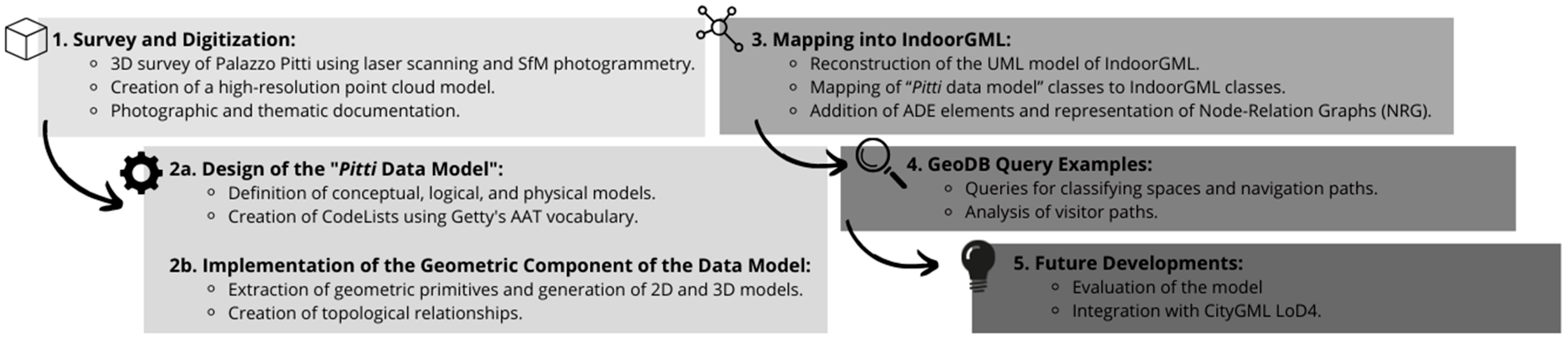
2. Methodology
2.1. Building as a Complex System
- Actors/people (designers, clients, users, managers, conservators, etc.).
- Material (structures, installations, contents, state of conservation, documentation, literature, etc.).
- Immaterial (spaces, functions, typologies, distribution, symbols, deficiencies, representativeness, resilience, etc.).
- The evolution of these components over time.
- The interactions generated by the components and their variations.
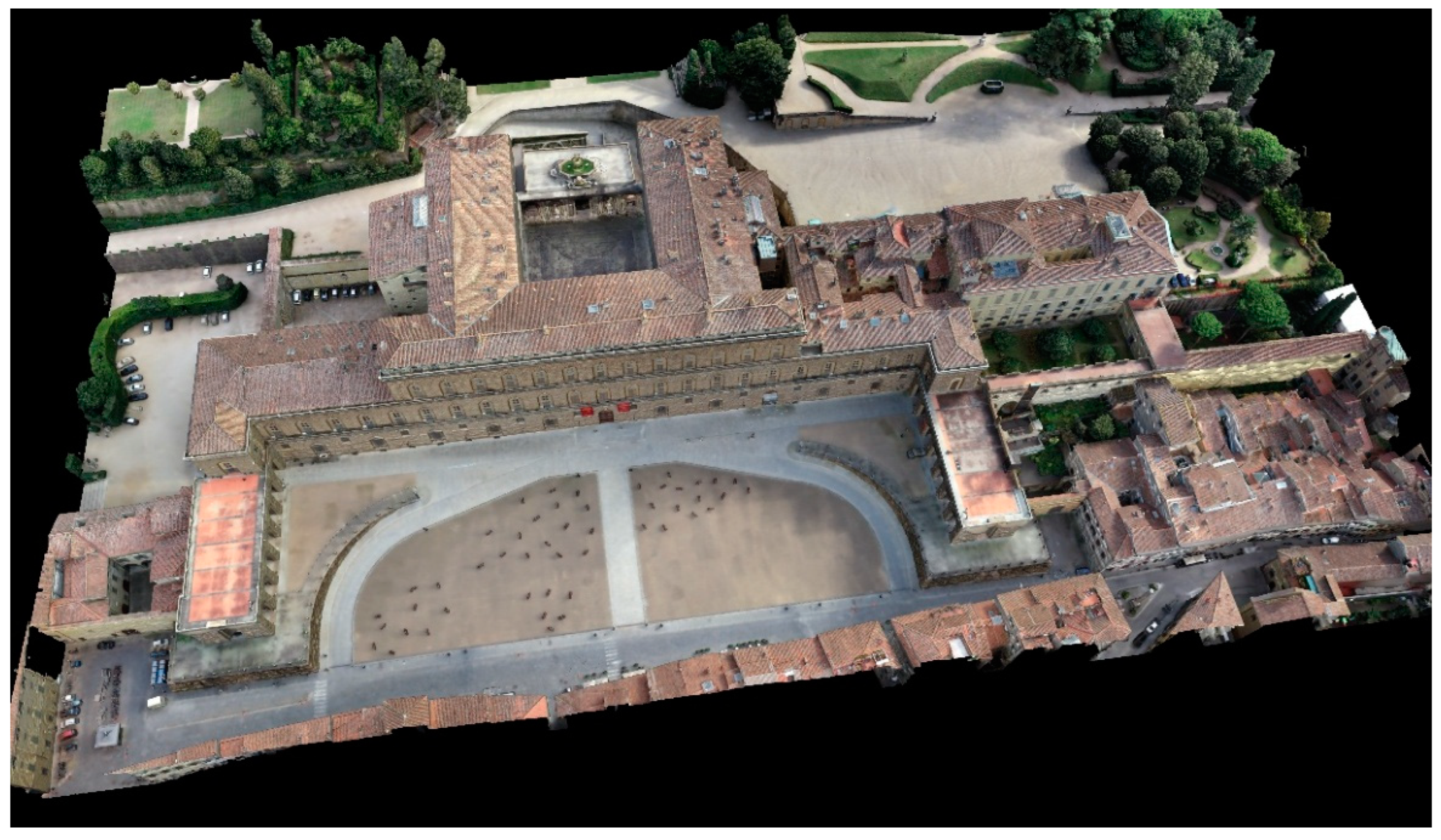
2.2. Surveying Process as a Complex System: The Case Study of Pitti Palace
- The measurement of checkpoints, then removed as soon as possible (particularly in exhibition spaces);
- Three-dimensional scans;
- Data processing;
- The drawing of 2D vector drawings, such as plans and elevations.
2.3. Project’s Contribution to the Contemporary Scientific Paradigm
- They emerge from a case study, but their development is designed for a more general application to the built heritage domain, particularly when characterized by complexity in the various declinations illustrated in Section 2.1;
- They are found on rigorous and exhaustive geometric data coming from a survey with geomatic techniques;
- They valorize the third dimension in describing spaces in order to fully exploit their topological relationships;
- They “translate” the initial data model to lead the work to adopt widespread geospatial standards;
- They adopt a controlled vocabulary to minimize uncertainty in feature identification, even in the presence of specialized terms that are sometimes related to local building traditions;
- They consider the management of the survey process, understood as a set of activities that must be repeated over time so that the changes made to the building correspond to those made to its digital reference, in order to preserve the twinning process effectively.
3. State-of-the-Art and Reference Standards: INSPIRE, CityGML, and IndoorGML
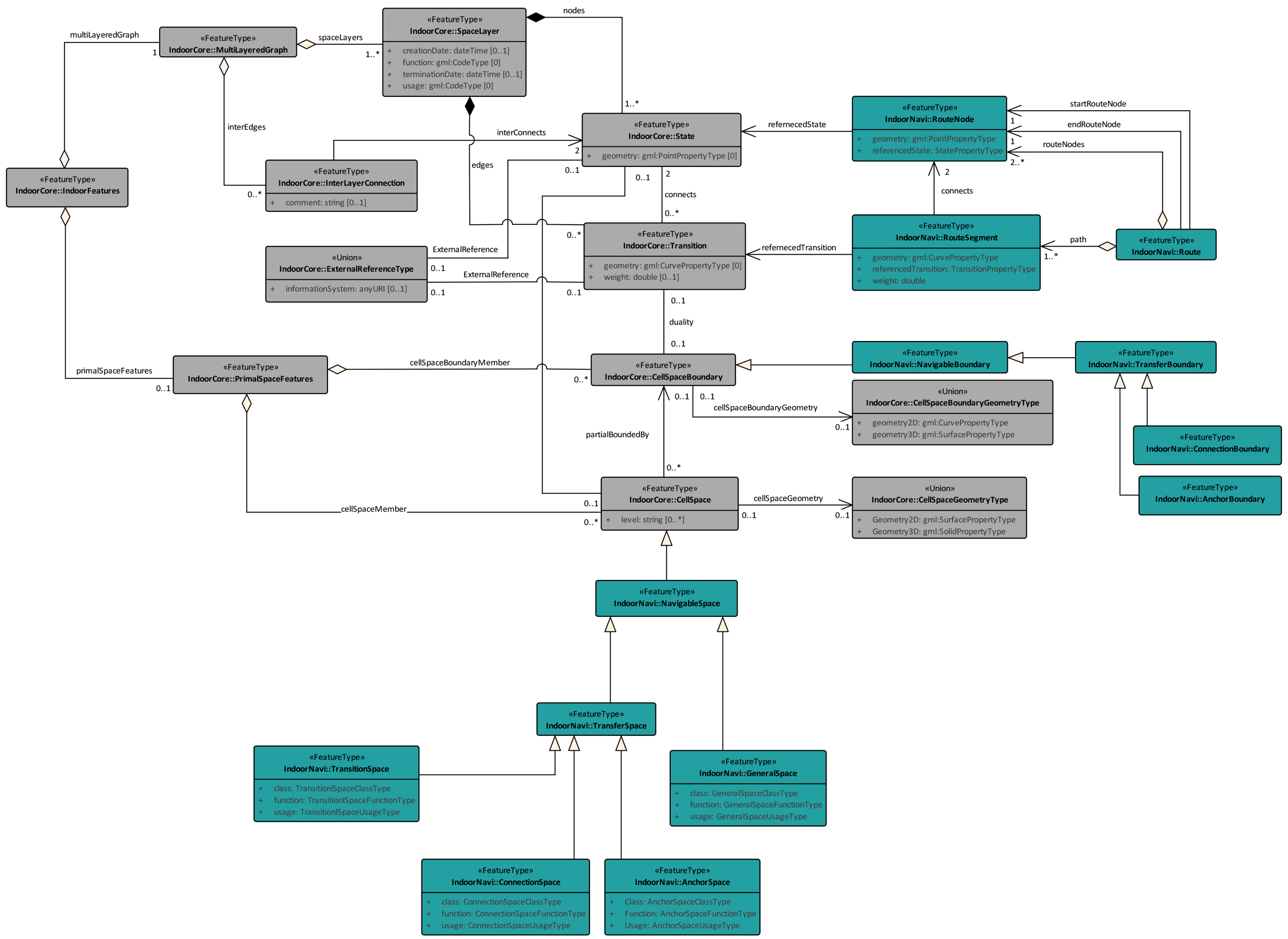
3.1. Semantic Representation in IndoorGML
- The ClassType attribute allows spaces to be classified according to their defined function, e.g., museum or administrative rooms;
- The FunctionType attribute expresses the main purpose of the space, e.g., living room or kitchen;
- The UsageType attribute may be used if the way the space is used differs from the function.
3.2. Geometric Representation in IndoorGML
- As an External Reference to objects defined in other datasets (e.g., to geometric information defined in CityGML, IFC, etc.);
- As an explicit representation of the geometry in IndoorGML;
- Or it is possible that no geometric information is included at all.
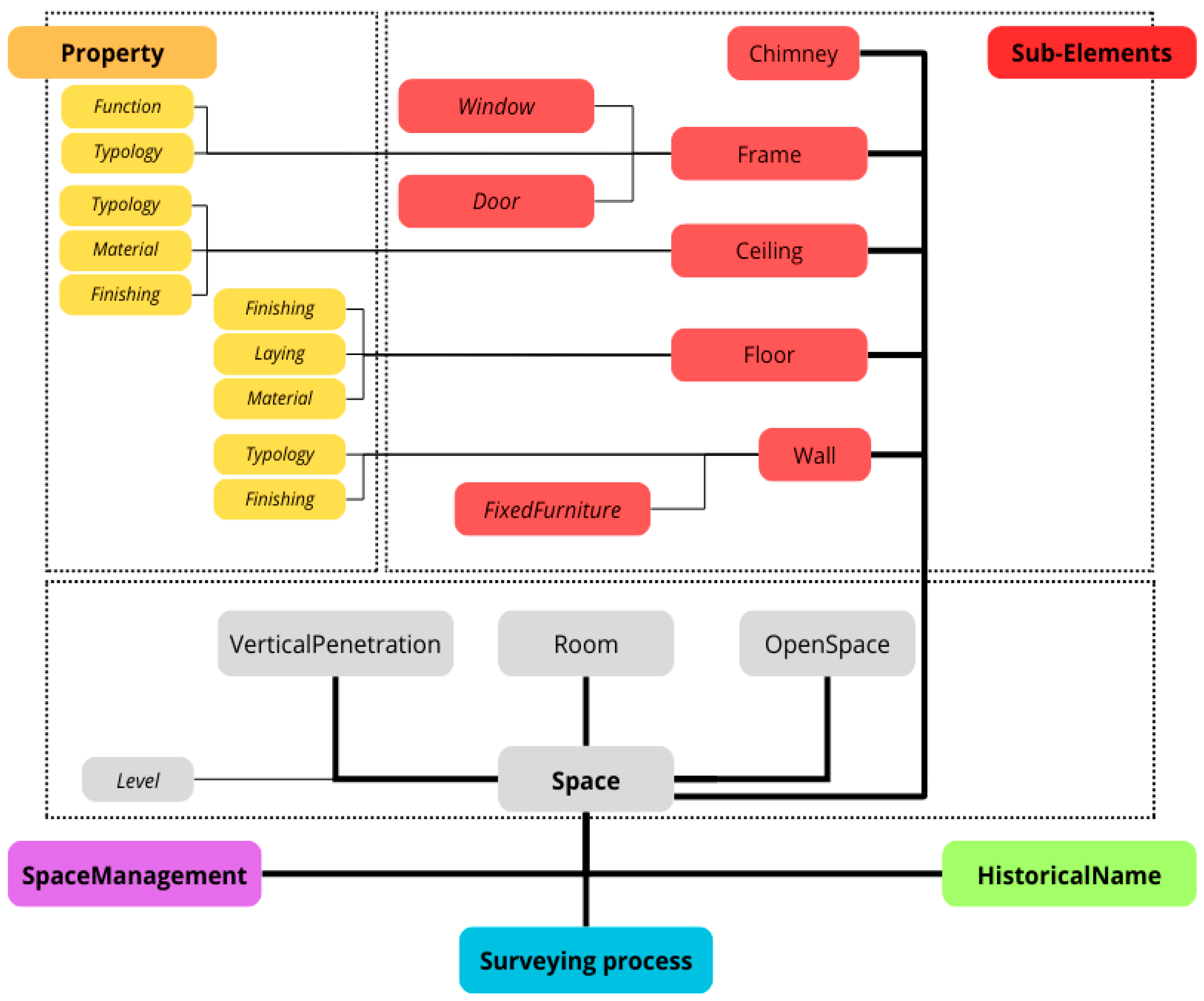
4. The “Pitti Data Model” Design
- Management aspects, referred to past and contemporary uses,
- Historical aspects, related to the naming of spaces over time,
- Three-dimensional survey process related elements.
- “Room”: a generic internal space of the building;
- “VerticalPenetration”: volumes that intersect multiple levels of the building and serve a distribution function within the building or system;
- “OpenSpace”: open but defined spaces, not completely enclosed but still spatially defined.
4.1. Data Structure: From the Conceptual to the Physical Model
4.2. Element Types That Describe Functional and Usage Aspects
4.3. Element Type That Describes the Geometric and Material Consistency of Objects and Surfaces
4.3.1. Frames
4.4. Element Types That Describe the Surveying Process
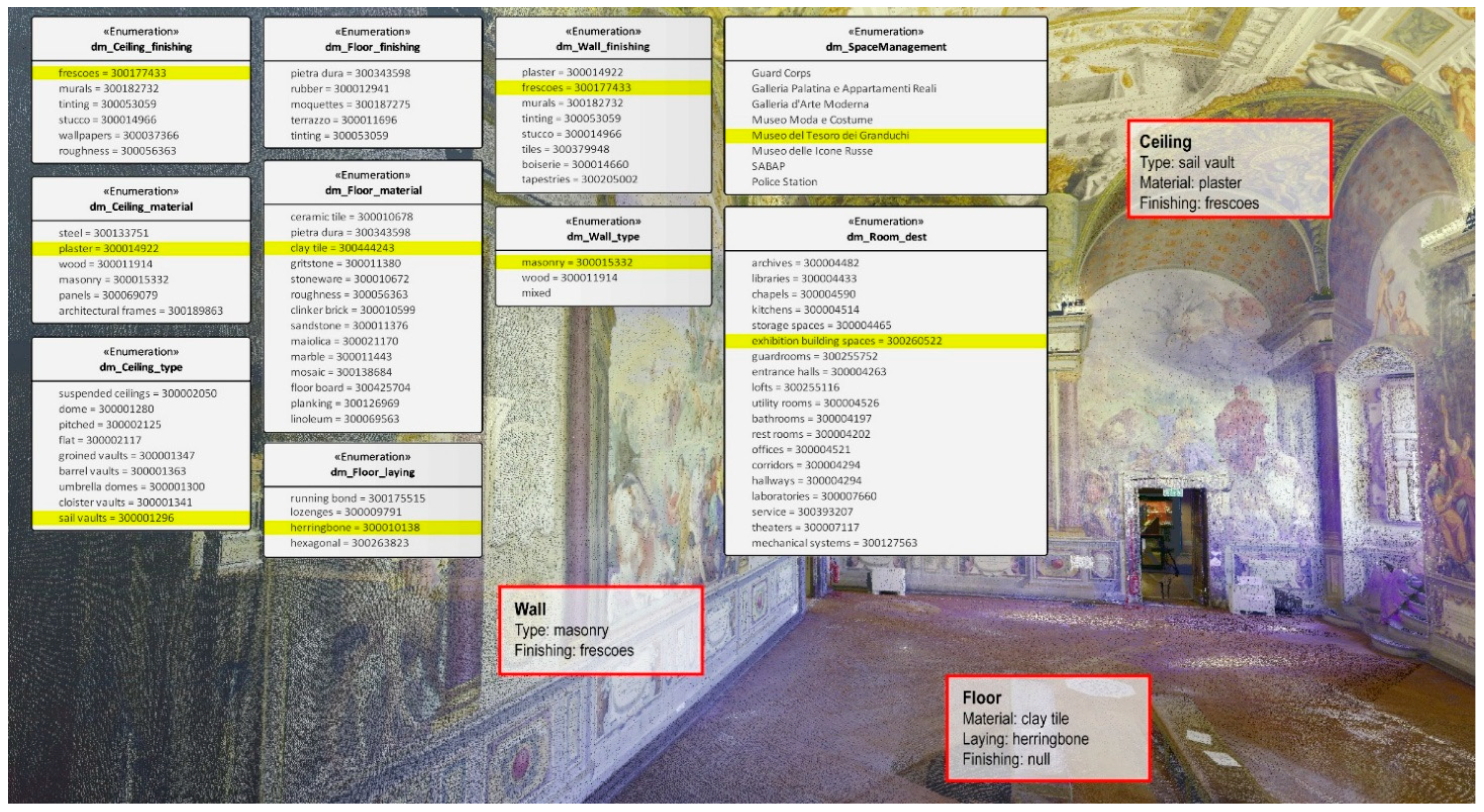
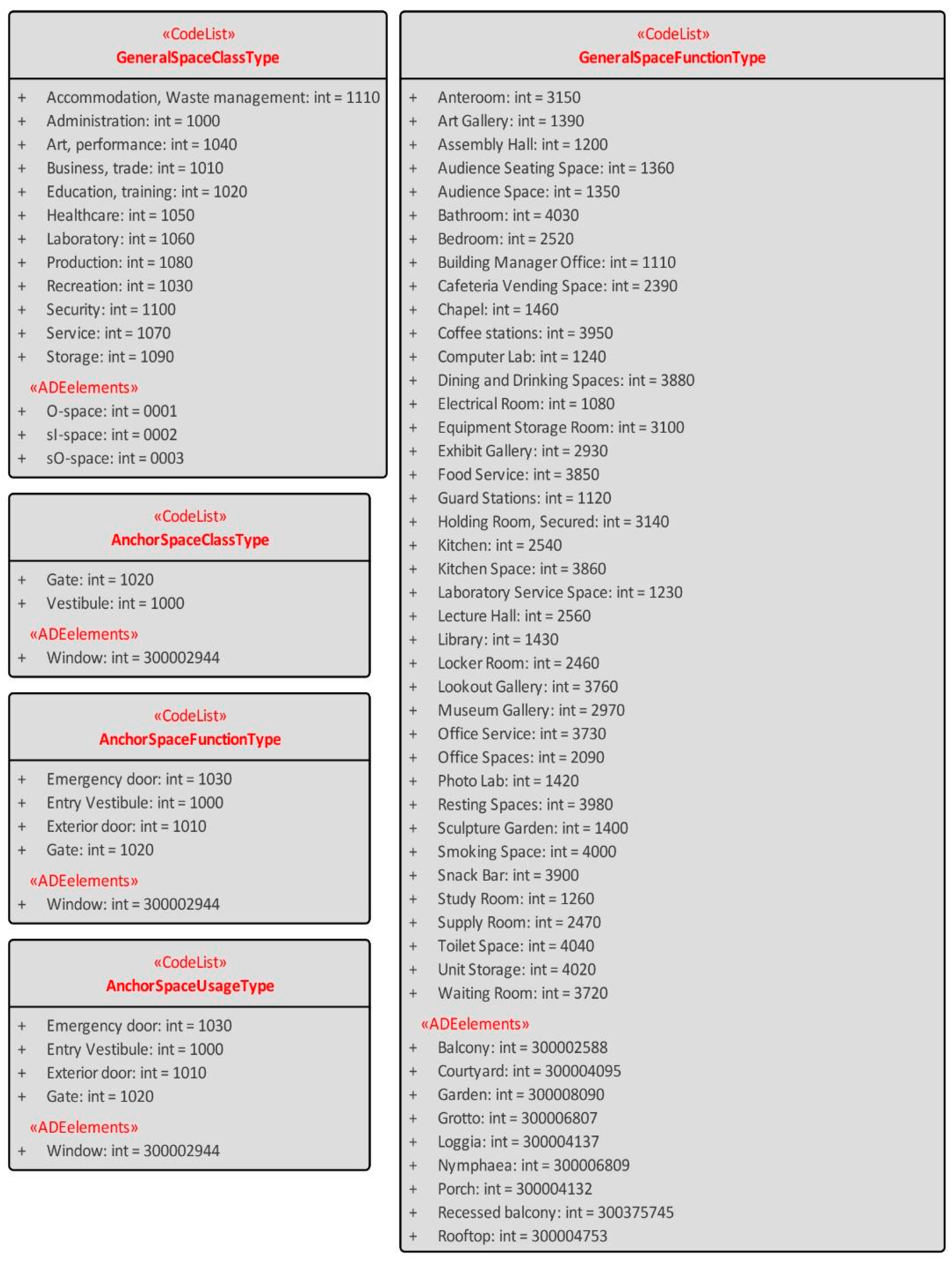
4.5. Adopted Vocabulary
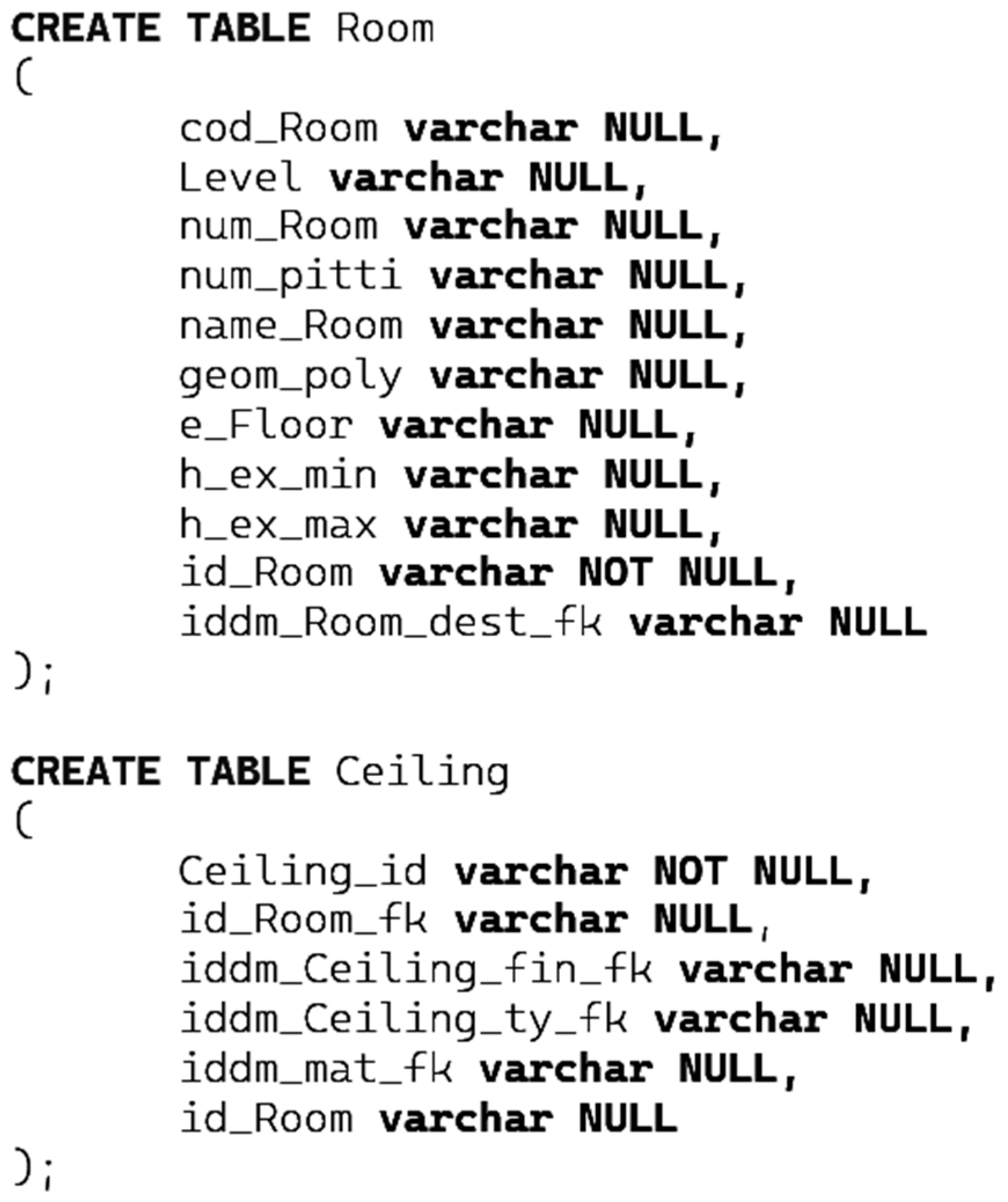
5. The “Pitti Data Model” Implementation
5.1. Geometry Component
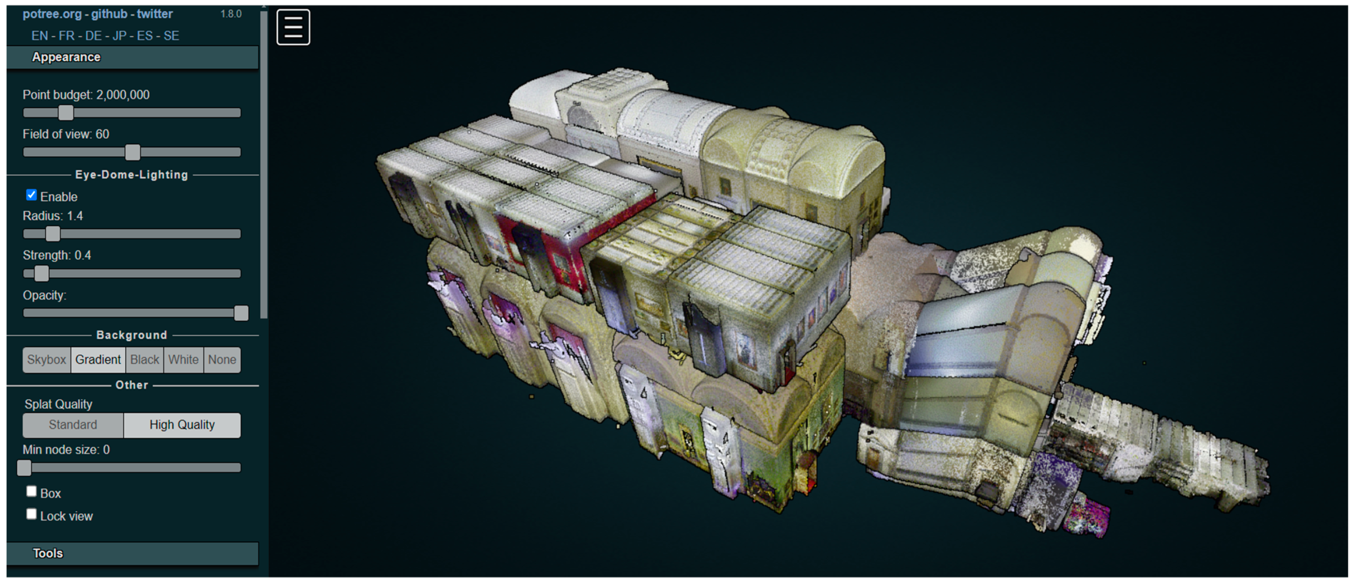
5.1.1. Primitive Element Extraction
- The identifying code of the space (e.g., 11,060);
- The current name in use (e.g., Sala delle Nicchie);
- The height value, expressed for rooms with vaulted ceilings by the height at the crown (maximum height, in meters) and the height at the spring line (minimum height, in meters).
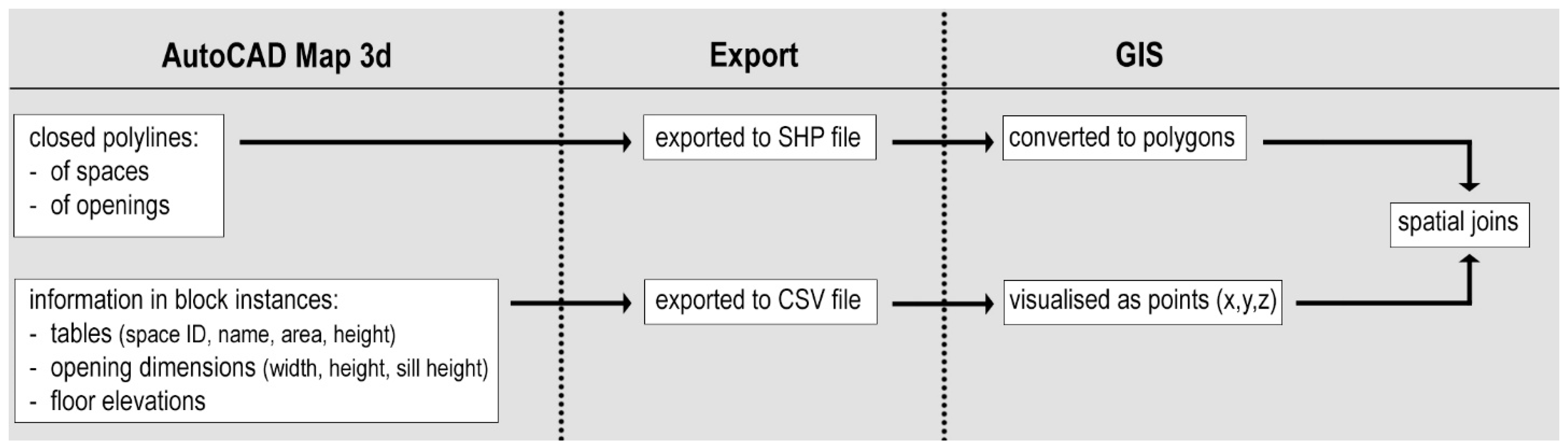
5.1.2. Generation of 2D and 3D Space Geometries and Creation of Topological Relationships
5.1.3. Geoprocessing of Imported Files
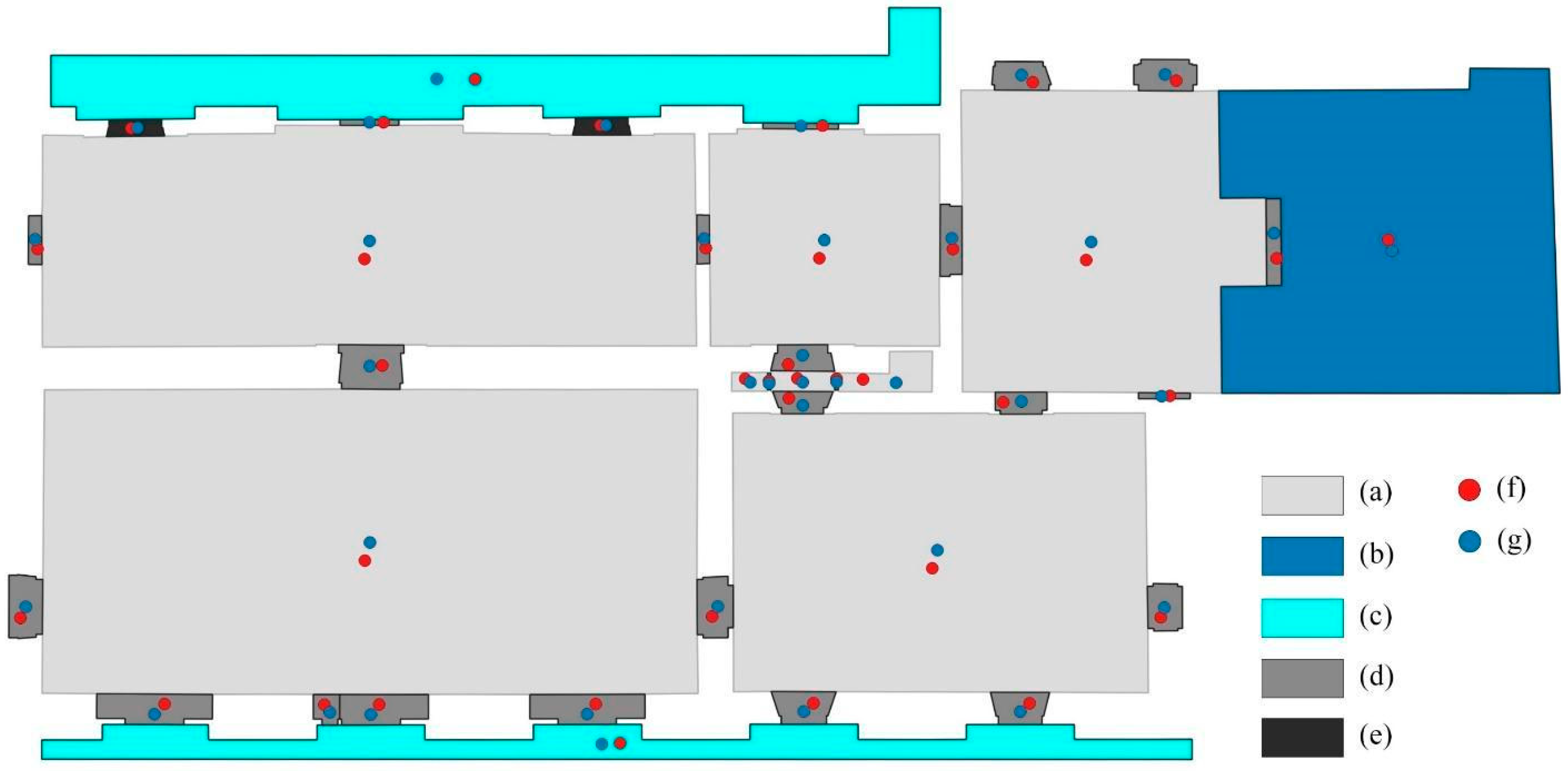
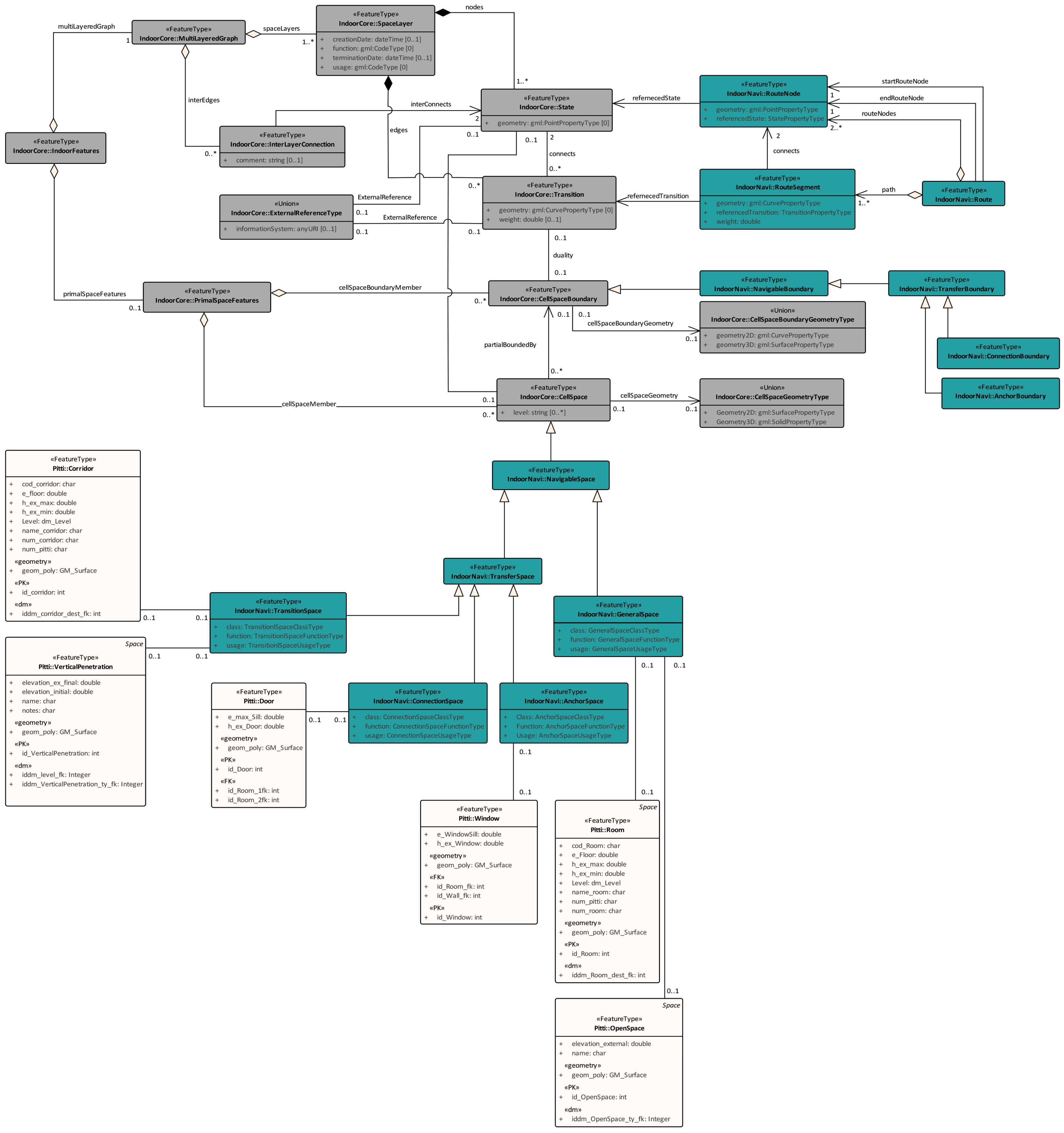
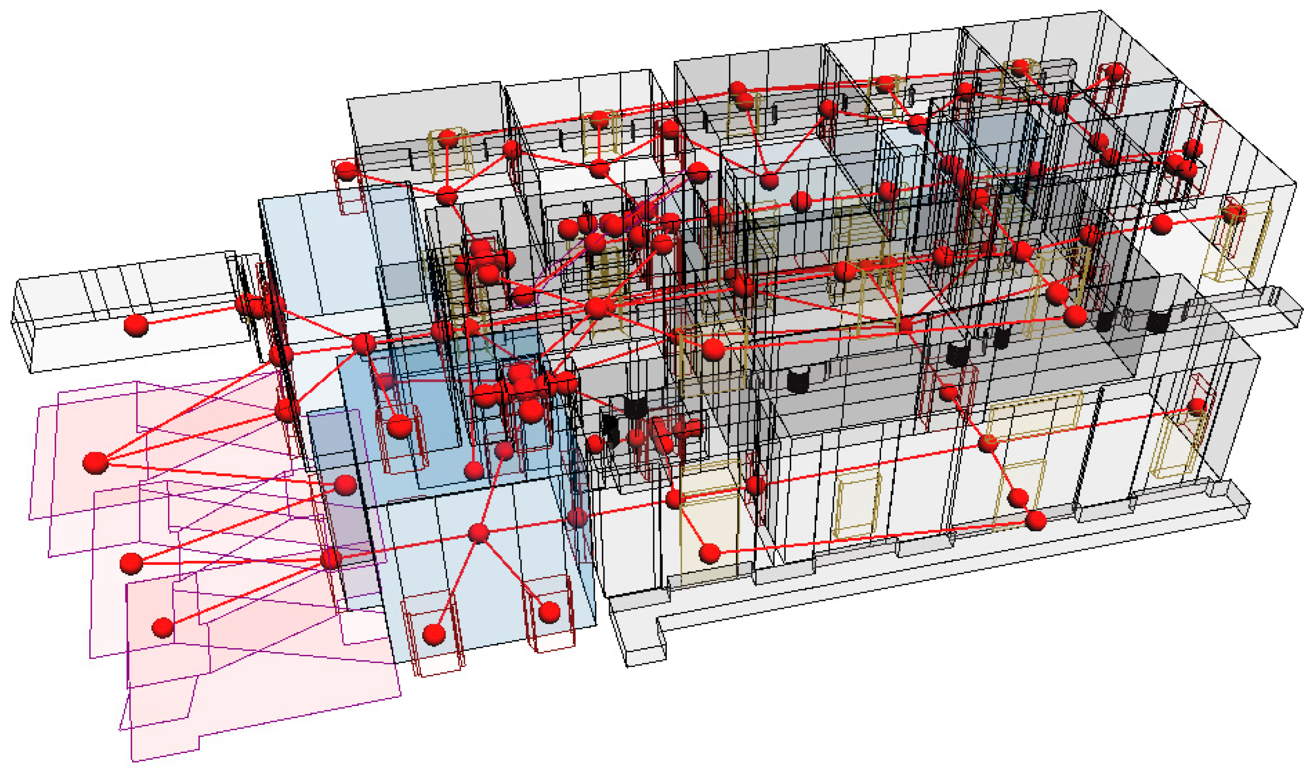
6. The “Pitti Data Model” Mapping into IndoorGML Standard
6.1. Reconstruction of IndoorGML UML Model
6.2. Mapping of the Pitti Data Model to IndoorGML
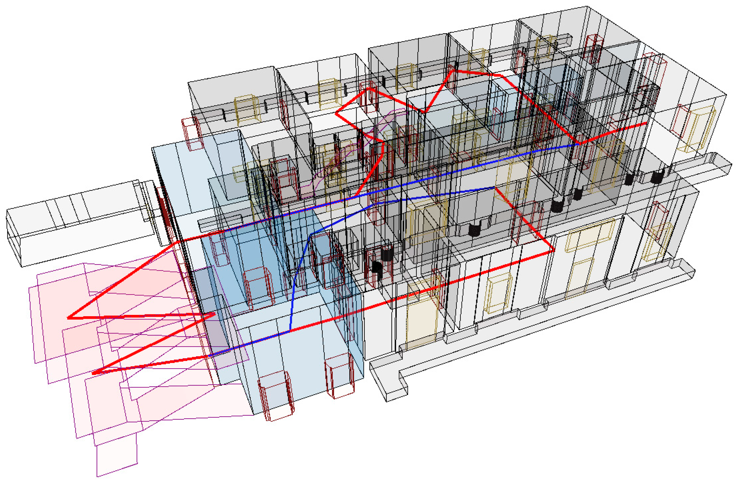
- Visitors can be assigned routes optimized for accessing exhibitions, with lower weights assigned to transitions leading to main galleries;
- Staff members may follow routes prioritizing technical areas, storage rooms, or service zones, avoiding interference with public areas.
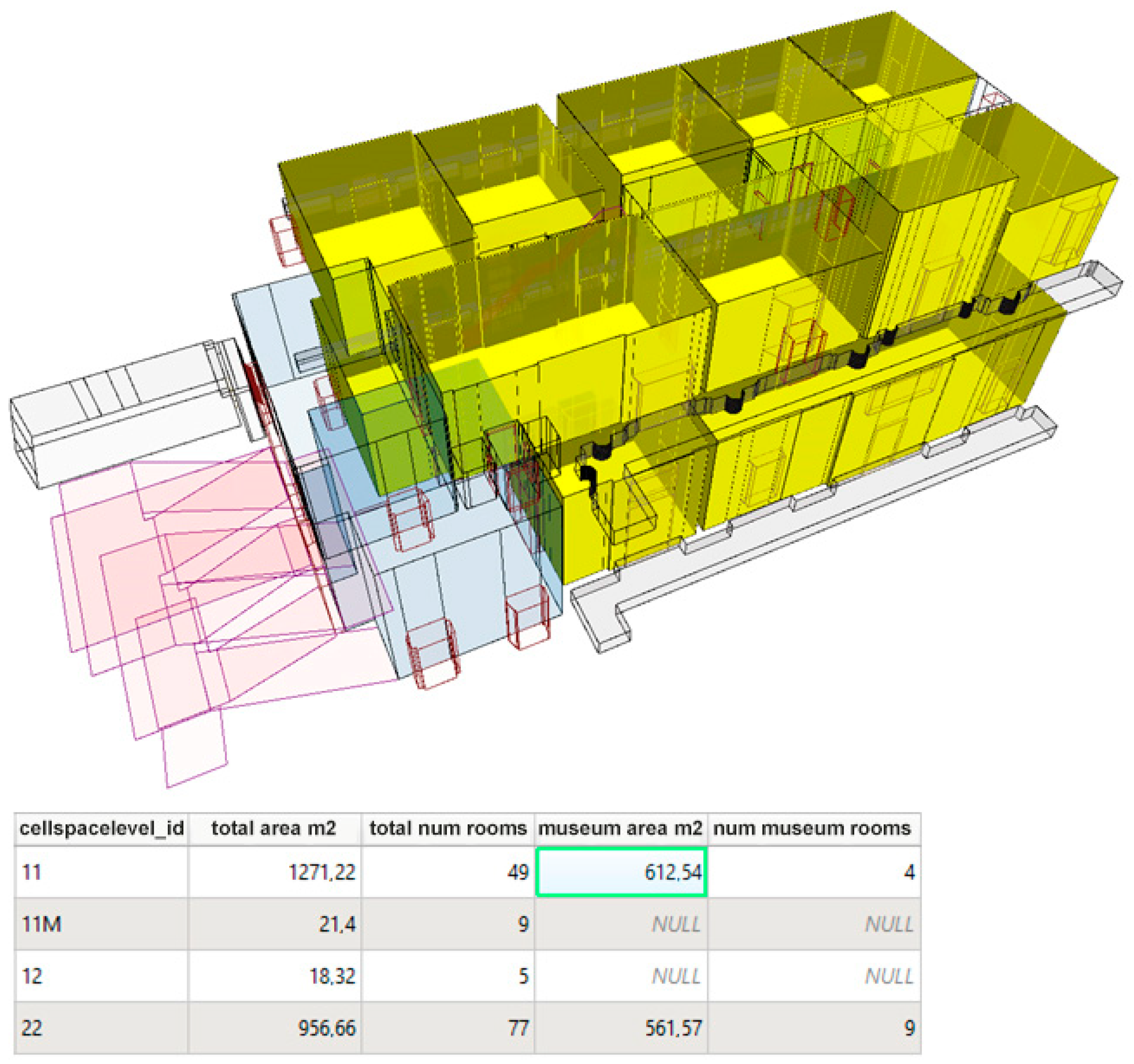
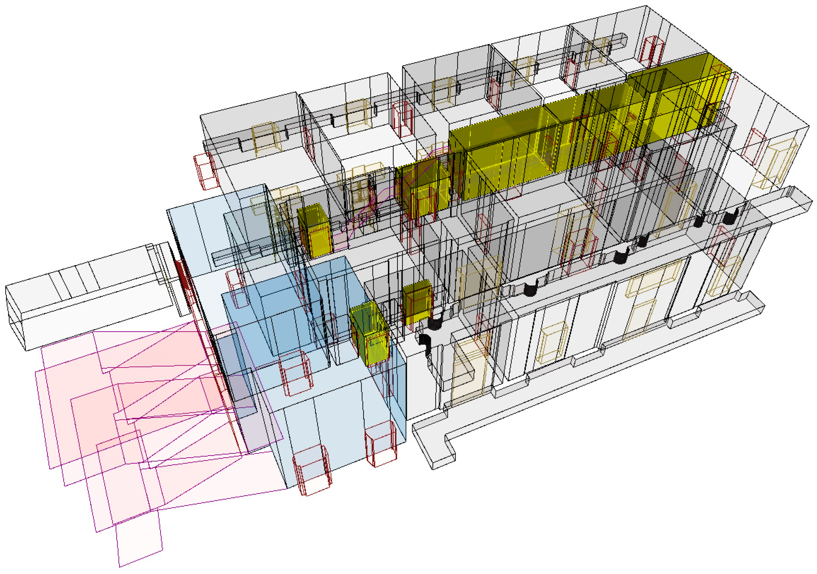
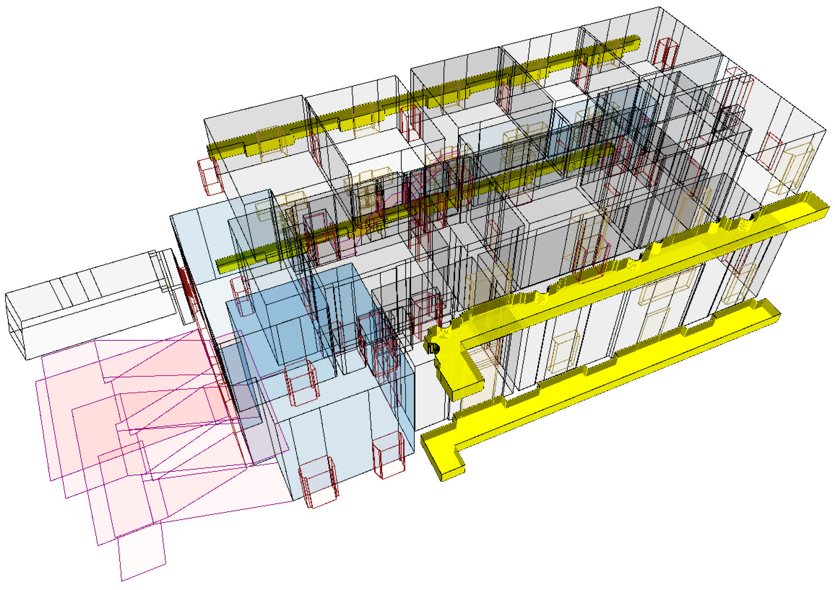
7. Examples of GeoDB Use and Query
8. Conclusions and Future Work
Author Contributions
Funding
Data Availability Statement
Acknowledgments
Conflicts of Interest
Abbreviations
| AAT | Art & Architecture Thesaurus |
| ADE | Application Domain Extension |
| BIM | Building Information Modeling/HBIM = Historic Building Information Modeling |
| CAD | Computer-Aided Design |
| CIDOC CRM | Conceptual Reference Model by ICOM (International Council of Museums) |
| CRS | Coordinate Reference System |
| DBMS | Database Management System |
| DDL | Database Definition Language |
| DT | Digital Twin |
| FAIR | Findable, Accessible, Interoperable, and Reusable |
| GeoDB | Geospatial Database |
| GIS | Geographic Information System |
| GML | Geography Markup Language |
| GNSS | Global Navigation Satellite System |
| HDT | Heritage Digital Twin |
| HDTO | Heritage Digital Twin Concept Ontology |
| HVAC | Heating, Ventilation, and Air Conditioning |
| IFC | Industry Foundation Classes |
| IMDF | Indoor Mapping Data Format |
| INSPIRE | Infrastructure for Spatial Information in Europe/BU = Buildings (INSPIRE theme) |
| ISO/TC211 | International Organization for Standardization, Technical Committee 211 (Geomatics) |
| NRG | Node-Relation Graphs |
| OCL | Object Constraint Language |
| OGC | Open Geospatial Consortium |
| PIM | Platform Independent Model |
| PSM | Platform Specific Model |
| RDN | Rete Dinamica Nazionale |
| SfM | Structure from Motion |
| SQL | Structured Query Language |
| UAV | Unmanned Aerial Vehicle |
| UML | Unified Modeling Language |
| XML | Extensible Markup Language |
References
- European Parliament and Council of the European Union. Decision (EU) 2022/2481 of the European Parliament and of the Council of 14 December 2022. Available online: https://eur-lex.europa.eu/eli/dec/2022/2481/oj (accessed on 30 October 2024).
- European Commission. Recommendation (EU) 2021/1970 of the Commission of 6 October 2021. Official Journal of the European Union. 2021. Available online: https://eur-lex.europa.eu/legal-content/EN/TXT/?uri=CELEX%3A32021H1970 (accessed on 30 October 2024).
- European Union. Declaration of Cooperation of the European States on the Digitization of Cultural Heritage, 9 April 2019. Available online: https://ec.europa.eu/newsroom/repository/document/2019-15/scanned_signed_declaration_090419_A4EA8EC1-E348-62E7-2257B0139A47C785_58564.pdf (accessed on 13 March 2025).
- European Commission, Directorate-General for Research and Innovation. Stakeholders’ Survey on a European Collaborative Cloud for Cultural Heritage—Report on the Online Survey Results. Publications Office of the European Union. 2022. Available online: https://data.europa.eu/doi/10.2777/691331 (accessed on 30 October 2024).
- Grieves, M. Completing the cycle: Using PLM information in the sales and service functions [slides]. In Proceedings of the SME Management Forum, Troy, MI, USA, 31 October 2002. [Google Scholar]
- Grieves, M.; Vickers, J. Origins of the digital twin concept. Fla. Inst. Technol. 2016, 8, 3–20. [Google Scholar]
- Metcalfe, J.; Ellul, C.; Morley, J.; Stoter, J. Characterizing the Role of Geospatial Science in Digital Twins. ISPRS Int. J. Geo-Inf. 2024, 13, 320. [Google Scholar] [CrossRef]
- Patrucco, G.; Gómez, A.; Adineh, A.; Rahrig, M.; Lerma, J.L. 3D Data Fusion for Historical Analyses of Heritage Buildings Using Thermal Images: The Palacio de Colomina as a Case Study. Remote Sens. 2022, 14, 5699. [Google Scholar] [CrossRef]
- International Council on Monuments and Sites (ICOMOS). ICOMOS Charter—Principles for the Analysis, Conservation and Structural Restoration of Architectural Heritage. 2023. Available online: https://www.icomos.org/en/about-the-centre/179-articles-en-francais/ressources/charters-and-standards/165-icomos-charter-principles-for-the-analysis-conservation-and-structural-restoration-of-architectural-heritage (accessed on 30 October 2024).
- Almagro, A.; Carbonara, G.; Casiello, S.; Coppo, D.; Cundari, C.; De Fiore, G.; Docci, M.; Fondelli, M.; Kirova, T.; Mandelli, M.; et al. Verso la “Carta del Rilievo Architettonico”. In Il Rilievo dei Beni Architettonici per la Conservazione. Atti del Convegno di Napoli, 15/17 Aprile 1999; Cundari, C., Carnevali, L., Eds.; Edizioni Kappa: Roma, Italy, 2000. [Google Scholar]
- Tucci, G.; Conti, A.; Bonora, V.; Fiorini, L.; Pagliaricci, G. Recording Michelangelo’s David: Ultra-high resolution 3d scanning and modeling for digital and physical reproduction. Int. Arch. Photogramm. Remote Sens. Spat. Inf. Sci. 2023, XLVIII-M-2-2023, 1581–1588. [Google Scholar] [CrossRef]
- Leon, I.; Pérez, J.J.; Senderos, M. Advanced Techniques for Fast and Accurate Heritage Digitisation in Multiple Case Studies. Sustainability 2020, 12, 6068. [Google Scholar] [CrossRef]
- Niccolucci, F.; Felicetti, A. Digital Twin Sensors in Cultural Heritage Ontology Applications. Sensors 2024, 24, 3978. [Google Scholar] [CrossRef]
- Yang, X.; Grussenmeyer, P.; Koehl, M.; Macher, H.; Murtiyoso, A.; Landes, T. Review of built heritage modelling: Integration of HBIM and other information techniques. J. Cult. Herit. 2020, 46, 350–360. [Google Scholar] [CrossRef]
- European Commission, Directorate-General for Communications Networks, Content and Technology. Study on Quality in 3D Digitisation of Tangible Cultural Heritage—Mapping Parameters, Formats, Standards, Benchmarks, Methodologies, and Guidelines—Executive Summary; Publications Office of the European Union: Luxembourg, 2022. [Google Scholar]
- Tucci, G.; Conti, A.; Fiorini, L. Geomatics for structural assessment and surface diagnostic of CH. Procedia Struct. Integr. 2018, 11, 2–11. [Google Scholar] [CrossRef]
- Counsell, J.; Taylor, T. What are the goals of HBIM? In Heritage Building Information Modelling; Routledge: London, UK, 2017; pp. 15–31. [Google Scholar]
- Greco, G.M.; Floridi, L. The tragedy of the digital commons. Ethics Inf. Technol. 2004, 6, 73–81. [Google Scholar] [CrossRef]
- Goodchild, M.F. Geographical information science. Int. J. Geogr. Inf. Syst. 1992, 6, 31–45. [Google Scholar] [CrossRef]
- Korro Bañuelos, J.; Rodríguez Miranda, Á.; Valle-Melón, J.M.; Zornoza-Indart, A.; Castellano-Román, M.; Angulo-Fornos, R.; Pinto-Puerto, F.; Acosta Ibáñez, P.; Ferreira-Lopes, P. The Role of Information Management for the Sustainable Conservation of Cultural Heritage. Sustainability 2021, 13, 4325. [Google Scholar] [CrossRef]
- Wijesundara, C.; Sugimoto, S. Metadata model for organizing digital archives of tangible and intangible cultural heritage, and linking cultural heritage information in digital space. Libr. Inf. Sci. Res. E-J. 2018, 28, 58–80. [Google Scholar]
- ECHOES-ECCCH. The Cultural Heritage Cloud. Available online: https://www.echoes-eccch.eu (accessed on 9 December 2024).
- ESPADON. Available online: https://espadon.net/a-propos/ (accessed on 30 October 2024).
- De Luca, L. A digital ecosystem for the multidisciplinary study of Notre-Dame de Paris. J. Cult. Herit. 2024, 65, 206–209. [Google Scholar] [CrossRef]
- De Rosnay, M.D.; Stalder, F. Digital commons. Internet Policy Rev. 2020, 9, 15-p. [Google Scholar]
- Di Giorgio, S. Cultural Commons, la sfida dei beni. DigItalia 2013, 7, 151–155. Available online: https://digitalia.cultura.gov.it/article/view/580 (accessed on 9 December 2024).
- Pamart, A.; Abergel, V.; de Luca, L.; Veron, P. Toward a Data Fusion Index for the Assessment and Enhancement of 3D Multimodal Reconstruction of Built Cultural Heritage. Remote Sens. 2023, 15, 2408. [Google Scholar] [CrossRef]
- Niccolucci, F.; Markhoff, B.; Theodoridou, M.; Felicetti, A.; Hermon, S. The Heritage Digital Twin: A bicycle made for two. The integration of digital methodologies into cultural heritage research [version 1; peer review: 2 approved with reservations]. Open Res. Europe 2023, 3, 64. [Google Scholar] [CrossRef]
- CIDOC-CRM. Available online: https://cidoc-crm.org/Event/iso-211272023-has-been-released (accessed on 10 December 2024).
- Čeko, A.; De Walsche, J.; Vannucchi, F. What is Architecture? A Contested History of the Discipline and its Embedded Meanings. In Architecture’s Afterlife; Routledge: London, UK, 2024; pp. 22–33. [Google Scholar]
- Pollio, M.V. L’Architettura colla Traduzione Italiana e Comento del Marchese Berardo Galiani; Stamperia Simoniana: London, UK, 1758. [Google Scholar]
- Vesely, D.; Stara, A.; Carl, P. Architecture as a humanistic discipline. In The Latent World of Architecture; Routledge: London, UK, 2022; pp. 151–164. [Google Scholar]
- Leach, N. Rethinking Architecture: A Reader in Cultural Theory, 1st ed.; Routledge: London, UK, 1997. [Google Scholar] [CrossRef]
- Rossi, A. Architettura per i musei. In Teoria della Progettazione Architettonica; Samonà, G., Ed.; Dedalo: Bari, Italy, 1968; pp. 122–137. [Google Scholar]
- Brand, S. How Buildings Learn: What Happens after They’re Built; Penguin: London, UK, 1995. [Google Scholar]
- Fusco Girard, L. The Circular “Human-Centred” Adaptive Reuse of Cultural Heritage: Theoretical Foundations. In Adaptive Reuse of Cultural Heritage; Fusco Girard, L., Gravagnuolo, A., Eds.; Springer: Cham, Switzerland, 2024. [Google Scholar] [CrossRef]
- Sanpaolesi, P. Discorso sulla Metodologia del Restauro dei Monumenti; EDAM: Firenze, Italy, 1973; p. 63. [Google Scholar]
- Morin, E. La Sfida Della Complessità, Le Lettere. 2011. Available online: https://www.indiscreto.org/dobbiamo-riscoprire-la-complessita/ (accessed on 10 December 2024).
- Ceruti, M.; Parisi, G. Cosa Significa Complessità: Un Dialogo tra Giorgio Parisi e Mauro Ceruti. 2013. Available online: https://www.complexityinstitute.it/cosa-significa-complessita-un-dialogo-tra-parisi-e-ceruti/ (accessed on 10 December 2024).
- Allen, P.M. The importance of complexity for the research agenda in the built environment. Archit. Eng. Des. Manag. 2008, 4, 5–14. [Google Scholar] [CrossRef]
- Sigahi, T.F.; Sznelwar, L.I. Which complexity? A review of typologies and a framework proposal for characterizing complexity-based approaches. Kybernetes 2023, 53, 1374–1394. [Google Scholar] [CrossRef]
- Özyeşil, O.; Voroninski, V.; Basri, R.; Singer, A. A survey of structure from motion. Acta Numer. 2017, 26, 305–364. [Google Scholar] [CrossRef]
- Grussenmeyer, P.; Alby, E.; Assali, P.; Poitevin, V.; Hullo, J.F.; Smigiel, E. Accurate documentation in cultural heritage by merging TLS and high-resolution photogrammetric data. In Proceedings of the Videometrics, Range Imaging, and Applications XI, Munich, Germany, 23–26 May 2011; Remondino, F., Shortis, M.R., Eds.; Society of Photo-Optical Instrumentation Engineers (SPIE) Conference Series. Volume 8085, p. 808508. [Google Scholar] [CrossRef]
- Leica-Geosystems. Leica Cyclone ENTERPRISE. Available online: https://leica-geosystems.com/it-it/products/laser-scanners/software/leica-cyclone/leica-cyclone-enterprise (accessed on 30 October 2024).
- Bonora, V.; Meucci, A.; Conti, A.; Fiorini, L.; Tucci, G. Knowledge Representation of Built Heritage Mapping an Ad Hoc Data Model in OGC Standards: The Case Study of Pitti Palace in Florence, Italy. Int. Arch. Photogramm. Remote Sens. Spatial Inf. Sci. 2023, XLVIII-M-2-2023, 281–288. [Google Scholar] [CrossRef]
- Villafranca, M.d.M.; Lamolda, F.; Montufo, A.M.; Pérez, L.; Prados, B. El Sistema de Información de la Alhambra SIALH. Nuevas tecnologías en la tutela del Conjunto Monumental de la Alhambra y el Generalife. Virtual Archaeol. Rev. 2012, 3, 13–17. [Google Scholar] [CrossRef]
- Fassi, F.; Achille, C.; Mandelli, A.; Rechichi, F.; Parri, S. A New Idea of BIM System for Visualization, Web Sharing, and Using Huge Complex 3D Models for Facility Management. Int. Arch. Photogramm. Remote Sens. Spatial Inf. Sci. 2015, XL-5/W4, 359–366. [Google Scholar] [CrossRef]
- Mauro, A. From the Extraordinary Nature of the Great Pompeii Project to Planned Conservation. Int. Arch. Photogramm. Remote Sens. Spatial Inf. Sci. 2019, XLII-2/W11, 867–871. [Google Scholar] [CrossRef]
- Matrone, F.; Colucci, E.; Iacono, E.; Ventura, G.M. The HBIM-GIS Main10ance Platform to Enhance the Maintenance and Conservation of Historical Built Heritage. Sensors 2023, 23, 8112. [Google Scholar] [CrossRef]
- Néroulidis, A.; Pouyet, T.; Tournon, S.; Rousset, M.; Callieri, M.; Manuel, A.; Abergel, V.; Malavergne, O.; Cao, I.; Roussel, R.; et al. A Digital Platform for the Centralization and Long-Term Preservation of Multidisciplinary Scientific Data Belonging to the Notre Dame de Paris Scientific Action. J. Cult. Herit. 2024, 65, 210–220. [Google Scholar] [CrossRef]
- Brumana, R.; Quilici, S.; Oliva, L.; Previtali, M.; Gabriele, M.; Stanga, C. Multi-Sensor HR Mass Data Models Toward Multi-Temporal-Layered Digital Twins: Maintenance, Design and XR Informed Tour of the Multi-Stratified Appian Way (PAAA). Sensors 2023, 23, 8556. [Google Scholar] [CrossRef]
- INSPIRE BU. Data Specification on Buildings—Technical Guidelines, Version 3.0, European Commission Joint Research Centre. 2014. Available online: http://inspire.ec.europa.eu/id/document/tg/bu (accessed on 7 September 2023).
- Kolbe, T.H.; Kutzner, T.; Smyth, S.T.; Nagel, C.; Roensdorf, C.; Heazel, C. OGC City Geography Markup Language (CityGML): Conceptual Model Standard. 2021. Available online: http://www.opengis.net/doc/IS/CityGML-1/3.0 (accessed on 31 January 2023).
- ISO/TC 211; Technical Committees, Geographic Information/Geomatics. ISO: Geneva, Switzerland, 1994. Available online: https://www.iso.org/committee/54904.html (accessed on 12 December 2024).
- Geography Markup Language (GML). Available online: https://www.ogc.org/it/publications/standard/gml/ (accessed on 12 December 2024).
- ISO 19107:2019; Geographic Information—Spatial Schema. ISO: Geneva, Switzerland, 2019. Available online: https://www.iso.org/standard/66175.html (accessed on 12 December 2024).
- Noardo, F. Architectural heritage semantic 3D documentation in multi-scale standard maps. J. Cult. Herit. 2018, 32, 156–165. [Google Scholar] [CrossRef]
- Fernández-Freire, C.; Del Bosque González, I.; Vicent, J.; Pérez Asensio, E.; Fraguas-Bravo, A.; González, A.; Fábrega-Álvarez, P.; Parcero-Oubiña, C. A Cultural Heritage Application Schema: Achieving Interoperability of Cultural Heritage Data in INSPIRE. Int. J. Spat. Data Infrastruct. Res. 2013, 8, 74–97. [Google Scholar] [CrossRef]
- Chiabrando, F.; Colucci, E.; Lingua, A.; Matrone, F.; Noardo, F.; Spanò, A. A European interoperable database (EID) to increase resilience of cultural heritage. Int. Arch. Photogramm. Remote Sens. Spat. Inf. Sci. 2018, XLII-3-W4, 151–158. [Google Scholar] [CrossRef]
- Gkadolou, E.; Prastacos, P.; Loupas, T. Documentation of cultural heritage monuments with CityGML: An application for ancient theatres. AGILE GIScience Ser. 2020, 1, 4. [Google Scholar] [CrossRef]
- Corongiu, M. Modelling Railways in the Context of Interoperable Geospatial Data. Ph.D. Thesis, Technische Universität Braunschweig and University of Florence, Florence, Italy, 2021. Available online: https://hdl.handle.net/2158/1240386 (accessed on 30 March 2024).
- Lee, J.; Li, K.-J.; Zlatanova, S.; Kolbe, T.H.; Nagel, C.; Becker, T.; Kang, H.-Y. OGC® IndoorGML 1.1. 2020. Available online: http://www.opengis.net/doc/IS/indoorgml/1.1 (accessed on 31 January 2023).
- Kim, M.; Choi, H.-S.; Lee, J. Comparative Analysis of Building Models to Develop a Generic Indoor Feature Model. J. Korean Soc. Surv. Geod. Photogramm. Cartogr. 2021, 39, 297–311. [Google Scholar] [CrossRef]
- Claridades, A.R.C.; Choi, H.-S.; Lee, J. An Indoor Space Subspacing Framework for Implementing a 3D Hierarchical Network-Based Topological Data Model. ISPRS Int. J. Geo-Inf. 2022, 11, 76. [Google Scholar] [CrossRef]
- Kim, T.; Kim, K.-S.; Lee, J.; Li, K.-J. Extensions of IndoorGML 1.1—Indoor Affordance Spaces, OGC. 2022. Available online: http://www.opengis.net/doc/DP/IndoorGML1.1-IndoorAffordanceSpaces (accessed on 30 March 2024).
- CSI, OmniClass Construction Classification System (OCCS), Table 13: Spaces by Function, Table 14: Spaces by Form. 2014. Available online: http://www.omniclass.org (accessed on 7 September 2023).
- Diakite’, A.A.; Zlatanova, S.; Alattas, A.F.M.; Li, K.J. Towards Indoorgml 2.0: Updates and Case Study Illustrations. Int. Arch. Photogramm. Remote Sens. Spat. Inf. Sci. 2020, XLIII-B4-2020, 337–344. [Google Scholar] [CrossRef]
- Ledoux, H. Are your IndoorGML files valid? ISPRS Ann. Photogramm. Remote Sens. Spatial Inf. Sci. 2020, VI-4/W1-2020, 109–118. [Google Scholar] [CrossRef]
- Srivastava, S.; Maheshwari, N.; Rajan, K.S. Towards generating semantically-rich IndoorGML data from architectural plans. Int. Arch. Photogramm. Remote Sens. Spatial Inf. Sci. 2018, XLII-4, 591–595. [Google Scholar] [CrossRef]
- Li, K.-J.; Zlatanova, S.; Torres-Sospedra, J.; Perez-Navarro, A.; Laoudias, C.; Moreira, A. Survey on Indoor Map Standards and Formats. In Proceedings of the 2019 International Conference on Indoor Positioning and Indoor Navigation (IPIN), Pisa, Italy, 30 September–3 October 2019; pp. 1–8. [Google Scholar] [CrossRef]
- Wu, H. Integration of 2D Architectural Floor Plans into Indoor OpenStreetMap for Reconstructing 3D Building Models. Master’s Thesis, TU Delft, Delft University of Technology, Delft, The Netherlands, 2015. [Google Scholar]
- Mouratidis, G. Context Dependent Multimodal Routing in Indoor/Outdoor Environments Based on IndoorGML and OpenStreetMap. Master’s Thesis, Technische Universität München, Ingenieurfakultät Bau Geo Umwelt (BGU), Lehstuhl für Geoinformatik, Munich, Germany, 2015. Available online: https://mediatum.ub.tum.de/node?id=1291310&change_language=en (accessed on 30 March 2024).
- Sparx Systems. Enterprise Architect. Available online: https://sparxsystems.com/products/ea/ (accessed on 30 October 2024).
- Forlani Conti, M.; Facchinetti Bottai, F.; Baldini Giusti, L. Le mille stanze del Re. Firenze, Palazzo Pitti. Un organismo architettonico e le schede di catalogo. Boll. D’arte Minist. Per I Beni Attività Cult. 1979, 64, 79–82. [Google Scholar]
- ISO 19101-1:2014; Geographic Information—Reference Model—Part 1: Fundamentals. ISO: Geneva, Switzerland, 2014. Available online: https://www.iso.org/obp/ui/#iso:std:iso:19101:-1:ed-1:v1:en (accessed on 12 December 2024).
- INSPIRE Directive, Infrastructure for Spatial Information in Europe. Available online: https://inspire-geoportal.ec.europa.eu/srv/ita/catalog.search#/home (accessed on 12 December 2024).
- PostgreSQL. Available online: https://www.postgresql.org/ (accessed on 12 December 2024).
- West, M. Developing High Quality Data Models; Elsevier Science & Technology: Amsterdam, The Netherlands, 2011; ISBN 9780123751072. [Google Scholar]
- Forum on Information Standards in Heritage (FISH). Available online: https://heritage-standards.org.uk/ (accessed on 30 October 2024).
- Getty Vocabulary. Art and Architecture Thesaurus (AAT). Available online: https://www.getty.edu/research/tools/vocabularies/aat/ (accessed on 30 October 2024).
- Bonora, V.; Meucci, A.; Fiorini, L. Analysis of the Spatial-Semantic Coherence in the Getty AAT Vocabulary Data Structure—An Educational Experience. Int. Arch. Photogramm. Remote Sens. Spatial Inf. Sci. 2024, XLVIII-2/W4-2024, 79–85. [Google Scholar] [CrossRef]
- Schütz, M. Potree: Rendering Large Point Clouds in Web Browsers. Master’s Thesis, TU Wien, Wien, Austria, 2016. [Google Scholar]
- Schütz, M.; Ohrhallinger, S.; Wimmer, M. Fast Out-of-Core Octree Generation for Massive Point Clouds. Comput. Graph. Forum 2020, 39, 155–167. [Google Scholar] [CrossRef]
- Autodesk. ReCap Pro. Available online: https://www.autodesk.com/it/products/recap/free-trial (accessed on 30 October 2024).
- Veesus. Veesus Cad Plugins. Available online: https://www.veesus.com/software/ (accessed on 30 October 2024).
- Leica-Geosystems. Leica CloudWorx Plugin CAD. Available online: https://leica-geosystems.com/it-it/products/laser-scanners/software/leica-cloudworx (accessed on 30 October 2024).
- Tucci, G.; Conti, A.; Fiorini, L.; Corongiu, M.; Valdambrini, N.; Matta, C. M-BIM: A new tool for the Galleria dell’Accademia di Firenze. Virtual Archaeol. Rev. 2019, 10, 40–55. [Google Scholar] [CrossRef]
- Autodesk. AutoCAD Map 3D. Available online: https://www.autodesk.com/products/autocad/included-toolsets/autocad-map-3d (accessed on 30 October 2024).
- De Luca, L.; Busayarat, C.; Stefani, C.; Véron, P.; Florenzano, M. A semantic-based platform for the digital analysis of architectural heritage. Comput. Graph. 2011, 35, 227–241. [Google Scholar] [CrossRef]
- Puerto, A.; Castañeda, K.; Sánchez, O.; Peña, C.A.; Gutiérrez, L.; Sáenz, P. Building information modeling and complementary technologies in heritage buildings: A bibliometric analysis. Results Eng. 2024, 22, 102192. [Google Scholar] [CrossRef]
- Pocobelli, D.; Boehm, J.; Bryan, P.; Still, J.; Grau-Bové, J. BIM for heritage science: A review. Herit. Sci. 2018, 6, 30. [Google Scholar] [CrossRef]
- Duval, R. A Cognitive Analysis of Problems of Comprehension in a Learning of Mathematics. Educ. Stud. Math. 2006, 61, 103–131. [Google Scholar] [CrossRef]
- QGIS Development Team. Open Source Geospatial Foundation. QGIS Geographic Information System. Available online: https://qgis.org/ (accessed on 30 October 2024).
- Maseroli, R. Il nuovo sistema di riferimento geodetico nazionale: Stato attuale e prospettive future. Boll. Della Soc. Ital. Fotogramm. Topogr. 2013, 1, 67–83. [Google Scholar]
- Bonora, V.; Maseroli, R.; Mugnai, F.; Tucci, G. GNNS Control Network Supporting Large Historical Building Architectural Survey. Int. Arch. Photogramm. Remote Sens. Spat. Inf. Sci. 2021, XLVI-M-1-2021, 87–91. [Google Scholar] [CrossRef]
- Donkers, S. Automatic Generation of CityGML LoD3 Building Models from IFC Models. Ph.D. Thesis, Delft University of Technology, Delft, The Netherlands, 2013. [Google Scholar]
- Nikoohemat, S.; Diakité, A.; Lehtola, V.; Zlatanova, S.; Vosselman, G. Consistency grammar for 3D indoor model checking. Trans. GIS 2021, 25, 189–212. [Google Scholar] [CrossRef]
- Kolbe, T.H.; Plümer, L. Bridging the gap between GIS and CAAD: Geometry, referencing, representations, standards and semantic modelling. GIM Int. 2004, 18, 12–15. [Google Scholar]
- Alattas, A.; Oosterom, P.; Zlatanova, S.; Diakité, A.; Yan, J.; Netherlands, T. Developing a database for the LADM-IndoorGML model. In Proceedings of the 6th International FIG 3D Cadastre Workshop, Delft, The Netherlands, 2–4 October 2018; Available online: http://resolver.tudelft.nl/uuid:978df943-9c14-4389-8c8e-f0d14c94e72c (accessed on 30 March 2024).
- Yan, J.; Diakité, A.A.; Zlatanova, S. A generic space definition framework to support seamless indoor/outdoor navigation systems. Trans. GIS 2019, 23, 1273–1295. [Google Scholar] [CrossRef]
- pgRouting—Extends the PostGIS/PostgreSQL Geospatial Database. Available online: https://pgrouting.org/index.html (accessed on 13 December 2024).
- Kontarinis, A.; Zeitouni, K.; Marinica, C.; Vodislav, D.; Kotzinos, D. Towards a semantic indoor trajectory model: Application to museum visits. Geoinformatica 2021, 25, 311–352. [Google Scholar] [CrossRef]


| Block | ID | Name | Area (m2) | Height Min (m) | Height Max (m) | X | Y | Z |
|---|---|---|---|---|---|---|---|---|
| Room | 11060 | Sala delle Nicchie | 242.39 | 6.70 | 10.90 | 3999.69 | 7817.66 | 71.56 |
| 11080 | Sala Verde | 140.16 | 7.15 | 10.90 | 3982.72 | 7807.50 | 71.56 | |
| 11063 | - | 1.58 | - | 3.95 | 3989.79 | 7804.98 | 71.56 | |
| VerticalPenetration | A0033 | Ammannati | - | - | - | 3971.40 | 7787.84 | 71.56 |
| OpenSpace | C23 | Terrazza su Piazza | - | - | - | 3989.78 | 7819.24 | 71.56 |
| Block | ID | Windowsill Height (m) | Window Height (m) | Window Width (m) | Door Height (m) | Door Width (m) | X | Y | Z |
|---|---|---|---|---|---|---|---|---|---|
| Door | 110178 | - | - | - | 4.40 | 2.05 | 3990.10 | 7818.78 | 71.56 |
| 110184 | - | - | - | 5.10 | 2.37 | 3988.01 | 7797.98 | 71.56 | |
| Window | 110172 | 0.97 | 3.50 | 1.83 | - | - | 4014.89 | 7809.34 | 71.56 |
Disclaimer/Publisher’s Note: The statements, opinions and data contained in all publications are solely those of the individual author(s) and contributor(s) and not of MDPI and/or the editor(s). MDPI and/or the editor(s) disclaim responsibility for any injury to people or property resulting from any ideas, methods, instructions or products referred to in the content. |
© 2025 by the authors. Licensee MDPI, Basel, Switzerland. This article is an open access article distributed under the terms and conditions of the Creative Commons Attribution (CC BY) license (https://creativecommons.org/licenses/by/4.0/).
Share and Cite
Meucci, A.; Bonora, V.; Fiorini, L.; Conti, A.; Corongiu, M.; Romanelli, S.; Tucci, G. Mapping an Information Model for Historic Built Heritage into the IndoorGML Standard: The Case of the Pitti Palace. Heritage 2025, 8, 115. https://doi.org/10.3390/heritage8040115
Meucci A, Bonora V, Fiorini L, Conti A, Corongiu M, Romanelli S, Tucci G. Mapping an Information Model for Historic Built Heritage into the IndoorGML Standard: The Case of the Pitti Palace. Heritage. 2025; 8(4):115. https://doi.org/10.3390/heritage8040115
Chicago/Turabian StyleMeucci, Adele, Valentina Bonora, Lidia Fiorini, Alessandro Conti, Manuela Corongiu, Stefano Romanelli, and Grazia Tucci. 2025. "Mapping an Information Model for Historic Built Heritage into the IndoorGML Standard: The Case of the Pitti Palace" Heritage 8, no. 4: 115. https://doi.org/10.3390/heritage8040115
APA StyleMeucci, A., Bonora, V., Fiorini, L., Conti, A., Corongiu, M., Romanelli, S., & Tucci, G. (2025). Mapping an Information Model for Historic Built Heritage into the IndoorGML Standard: The Case of the Pitti Palace. Heritage, 8(4), 115. https://doi.org/10.3390/heritage8040115