2. Background
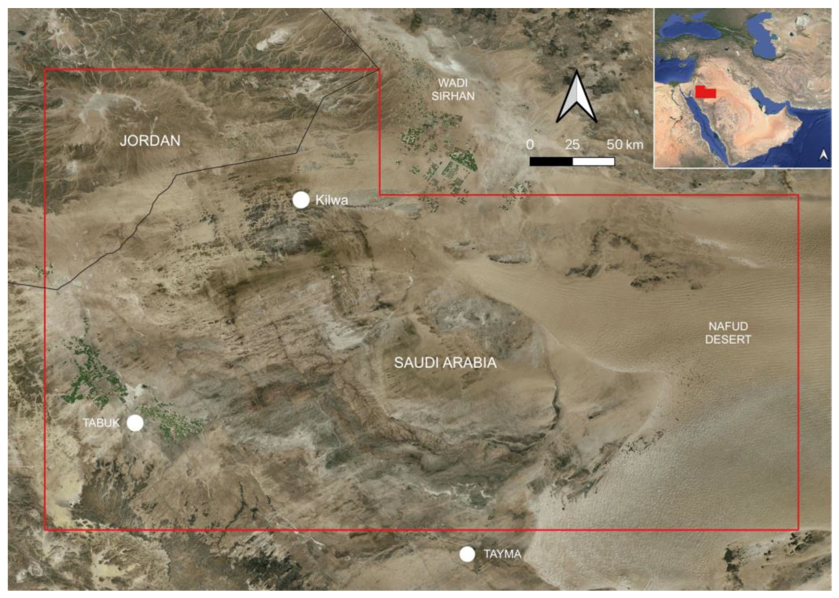
Geologically, the region is marked predominantly by sandstone beds, with thick gravels in the Wadi Tabuk at the western side of the survey area and the sands of the western Nafud at the eastern side [
4,
5]. In the Jordanian section of the survey area, there is a shift to limestones and deposits of sand, gravel, and clay. Topographically, the region is relatively low relief, particularly in comparison to the mountainous region west of the Wadi Tabuk. Agriculturally, the zones of irrigated farming are limited to the vicinity of the Wadi Tabuk and the Wadi Sirhan, which have been expanded and intensified in recent decades through the use of central pivot irrigation systems.
This survey is preceded by comparable archaeological remote sensing surveys by the Endangered Archaeology in the Middle East and North Africa (EAMENA) project of the region to the west in the area affected by the ongoing Neom development, a controversial mega-city and wider landscape development [
6], and the central and eastern Nafud desert to the east [
7]. The area to the north has been covered briefly by an alignment of temporary Roman military camps in the otherwise remote, relatively empty landscapes of south-east Jordan [
8]. The types of structural features visible on satellite imagery in these regions include simple stone-walled corrals likely associated with forms of mobile pastoralism across millennia, as well as more morphologically distinct features such as large hunting kite structures and large rectangular mustatil architecture, both of which have been dated to the Neolithic period [
1,
2,
3,
9,
10,
11]. Cairn structures, often raised as burial monuments, are also frequently detected and built across the prehistoric and pre-Islamic features, with more complex forms such as pendants and ringed cairns emerging in the Bronze Age [
2].
To the south of the current survey area, a massive state-level investment in the region around AlUla and Kaybar in the past decade has seen major advances in understanding of the density and complexity of archaeological sites, in terms of the prehistoric landscapes of the region [
2,
3]. The survey work in this area by the Aerial Archaeology of the Kingdom of Saudi Arabia (AAKSA) project built on the pioneering work of Professor David Kennedy [
9,
10,
11], which is also an origin point for the EAMENA methodology, but with the recent work around AlUla being significantly enhanced by a combination of low-altitude aerial survey, ground investigations and site excavations, provides a wide range of regional contextual information.
The survey area has only been previously subject to relatively limited study, with some notable site-specific exceptions, and has arguably been perceived as a relatively peripheral, arid landscape on the Nafud and its western margins. The area was covered by a limited ground survey in the late 1970s [
12]. More detailed investigations have taken place at the walled oasis site at Qurayyah and the remote Byzantine monastic site at Kilwa [
13,
14]. Recent survey and excavation of kite structures in the north and north-western sections of the survey area have produced remarkable new information in terms of the dating of these structures, as well as the centrality of kite design among communities who built and lived around these monumental sites. Scientific dating at kite structures within the survey area in southern Jordan and northern Saudi Arabia has indicated that they date back at least as far as 8000 BCE [
15,
16], while investigations of associated camps and rock art in Jordan have produced evidence of scaled illustrations of kites and a remarkable anthropomorphic stele [
17].
3. Methodology
This survey follows the standard EAMENA methodology of optically analysing open-source satellite imagery of a defined survey area, broken up into grids measuring 0.25 of a decimal degree latitude/longitude of around 25 km by 25 km (approximately 625 square kilometres). The present survey covered a total of 188 EAMENA grids covering a total area of approximately 117,500 square kilometres. The project uses the satellite imagery archive on Google Earth Pro (Version 7.3) as it has basic functionality for capturing geospatial data, and it also uses imagery on Bing Maps (Version 6.2) and Apple Maps (Version 3) if there is a lack of high-resolution imagery available for a specific area via Google. Google Earth Pro is also utilised because it incorporates an archive of imagery of different dates covering the same areas. Although there is a significant variation in the quantity of imagery tiles covering different areas, this allows sites to be identified that may only be visible on certain images, as well as the changing physical condition over time to be assessed. It is also essential to use open-source imagery platforms, as an investigation covering such an extensive area would not be economically viable for a project like EAMENA if imagery had to be purchased directly from commercial sources. Potential archaeological features are recorded on Google Earth Pro and then exported and uploaded to the EAMENA database with additional fields added covering the interpretation of each site and its current condition.
Each grid is examined systematically, and potential archaeological structures or other site types are observed optically and recorded as geospatial point data. On average, the available imagery will have an optical resolution of around 0.5 m, so that any feature visible measuring 0.5 m × 0.5 m would be visible as a single pixel on screen. In practice, it is unlikely that any single structure with a length or width dimension below 2 m would be identified, although there is variability depending on the image quality and materials used to build structures. In general, there is a relative consistency in the types of archaeological sites that are encountered in the arid zones of the Arabian Peninsula and can be confidently identified using this optical process. Most notably among these are stone-built enclosures linked to long-term pastoral utilisation of these landscapes, followed by stone cairns and small towers of varying complexity generally utilised as burial monuments. Once spatial data has been collected for a grid, it is uploaded to the EAMENA database with additional fields covering the form and condition of each site.
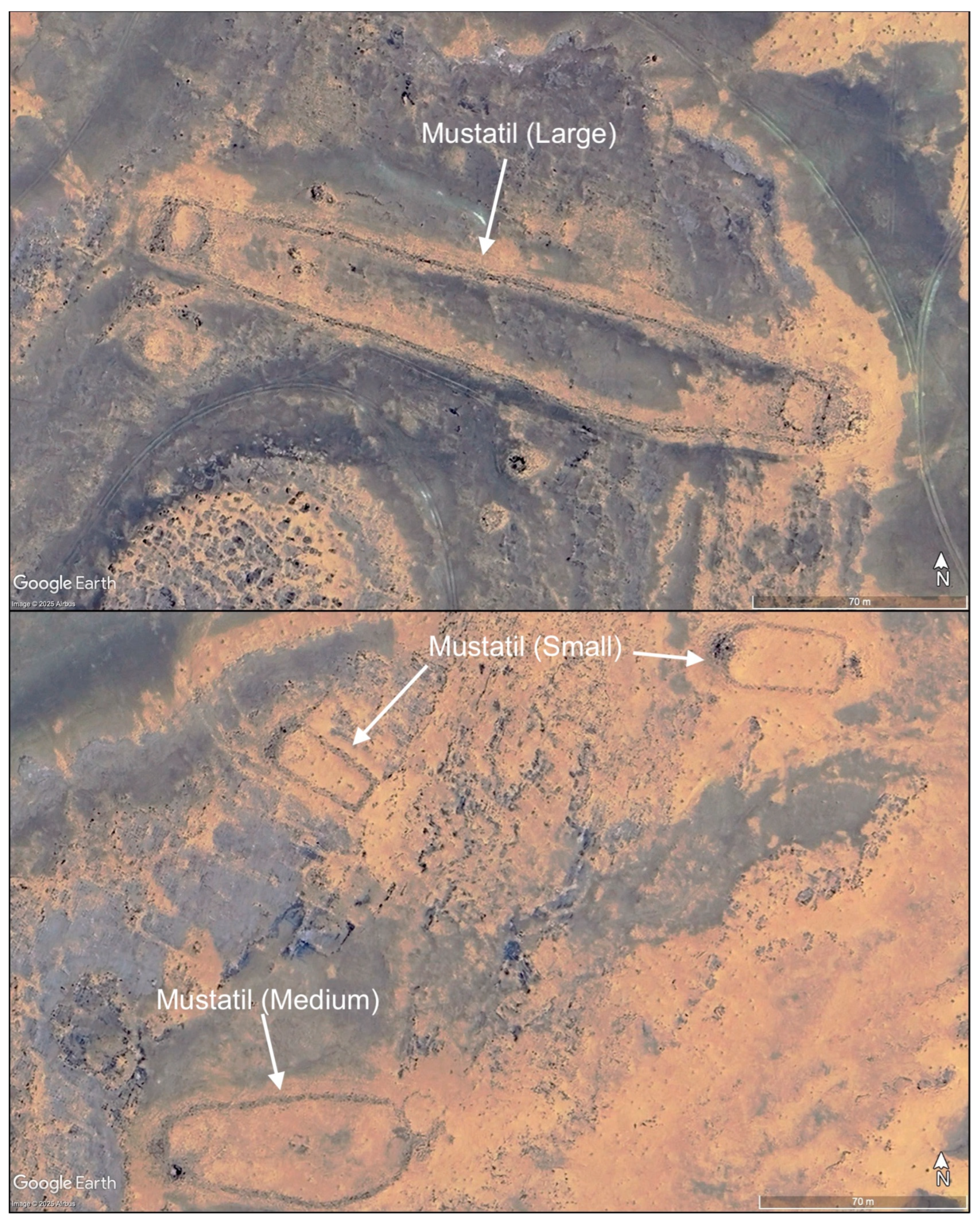
The EAMENA database records sites using fixed terminologies, which, in the case of site type interpretations, consists of a relatively short, simplified list designed to incorporate different archaeological site types encountered across the MENA region. To enhance the analysis of this data in this paper, a number of sub-divisions of site types were imposed for kite types, broadly distinguishing morphologically between V-shaped structures and more complex star-shaped and associated kites, as well as for mustatil structures [
1,
10] where an arbitrary division between small (<50 m in length), medium (50–100 m in length) and large (>100 m in length) was utilised. The project database is primarily focused on monitoring of archaeological heritage and is flexible in terms of what constitutes a single ‘site’ so, for instance, a large cluster of stone cairn piles may be defined as a site in one location, but might be broken up into individual features in another location depending on factors such as topography and perceived levels of threat to a site type or landscape.
A positive aspect of this rapid survey approach is that trends in the distribution of larger structures can be quickly built up across large areas, enabling new questions and observations to be developed. There are clear issues with this approach, notably human interpretation error, a bias towards the detection of larger sites, and a dependence on the quality of open-source imagery, but it is still a clear, low-cost, rapid methodology that can be employed to construct initial models of long-term human occupation and land-use, which can inform future ground-based fieldwork that can then break down the limitations and bias of a remote sensing approach [
18]. While this process of identifying morphological forms on satellite imagery may be replaced in the future by automated processes, at present, the human-led approach remains the most cost-effective means of rapidly surveying arid zones, being able to rapidly adapt to site morphological variability and identify new site types that do not readily fit within the pre-existing understanding of site types. The value of remote-sensing surveys without immediate follow-up of ground validation has been demonstrated repeatedly over the past two decades, particularly across the arid regions of southwest Asia [
6,
7], and the present study further develops the application of this approach in a challenging environment where the relative low-density of archaeological sites or perceived relevance has only attracted limited ground-based survey or excavation at a landscape scale in the past.
4. Results
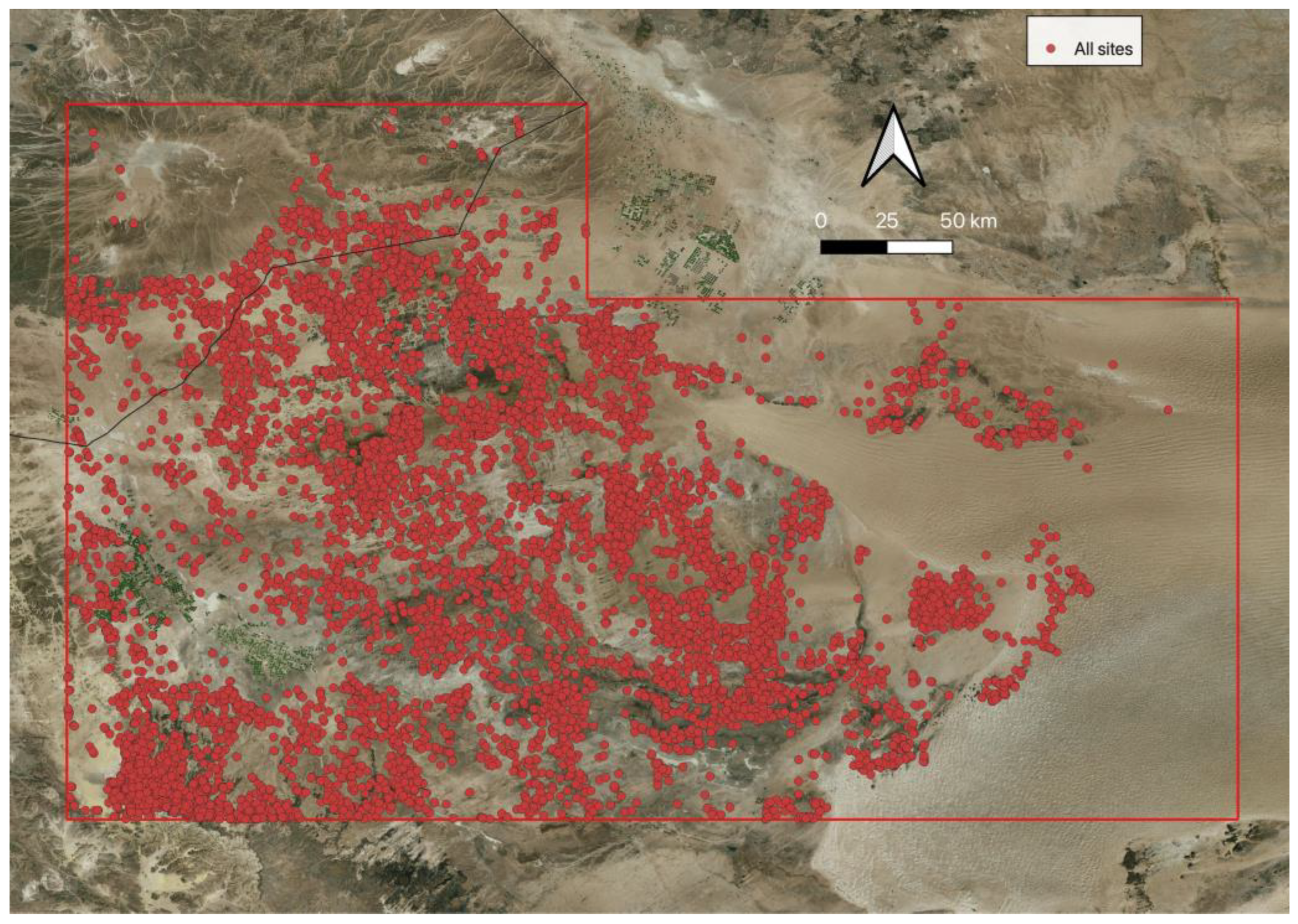
A total of 8559 sites were recorded across the survey area [
19], with an expected absence across the sands of the Nafud, although structures partially buried by sand dunes were identified in the survey of the eastern Nafud [
6] gat (
Figure 2). By far the most common type of feature recorded was simple sub-circular stone-walled enclosures, which were ubiquitous across the site distribution (
n = 7292). It is not possible to even approximate the date of these features based on their morphology, and it is likely that the majority were utilised by pastoralists across different periods to pen herd animals. This feature type is found throughout much of the survey area, and in some areas, such as the plains east of Wadi Nayyal, where large numbers of enclosures dispersed across the landscape are almost universally the only site type identified. A possible large settlement site was documented in the eastern section of the survey, consisting of a distinct, dense cluster around 100 walled enclosures built on the slopes of a plateau. This is very different from the limited enclosure clusters identified throughout the rest of the survey area, although given its location on the edge of the Nafud desert, it may have only been occupied seasonally.
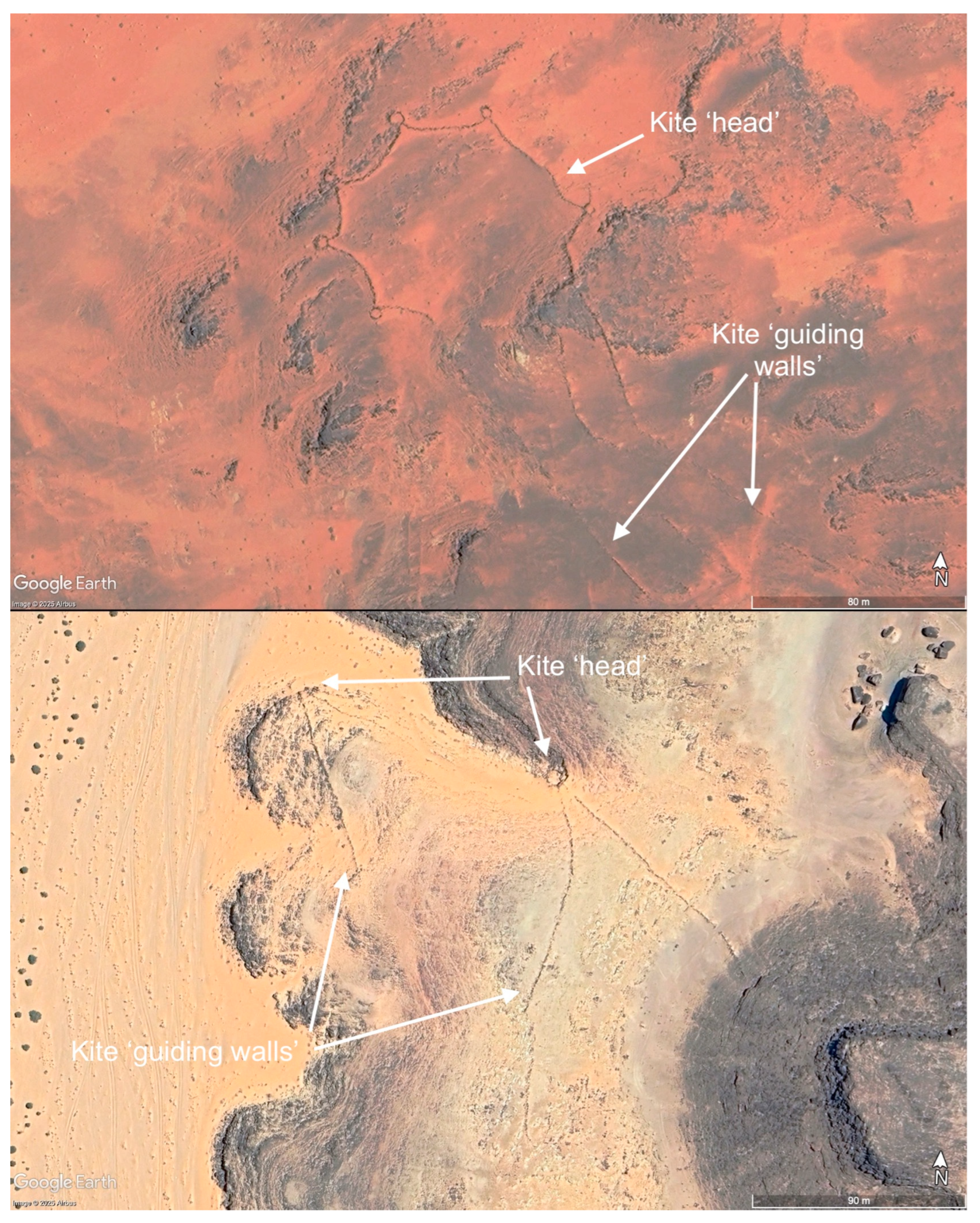
The survey has further extended the known distribution of kite structures in northern Arabia (
Figure 3 and
Figure 4). The identified kite structures occur in a range of scales and form complexities, but all utilise low guiding walls that are broadly accepted as funnelling wild fauna, most likely species of Gazelle, to an enclosed or in some way physically constrained area where game could be killed. A total of 275 possible kite structures were recorded across the survey area, broadly divided into star-shaped and associated forms best known from eastern Jordan (
n = 170), V-shaped forms of the Sinai-Negev tradition (
n = 56), and structures that were interpreted as kites at a lower certainty where the ‘head’ structure is not visible or identified, but the presence of converging wall lines is enough to presume they were likely part of kite structures (
n = 49). The principal increase in numbers was among the star-shaped and comparable structures in the central section of the survey area, with an increase in high certainty kites increasing from 55 to 169 in that region. Additionally, a few simple wall structures interpreted as ‘boundary/barrier’ features in this area that may also be connected to the guiding of game herds for hunting alongside the kites. The increase in the number of V-shaped kites, the type being largely confined to the south-west corner of the survey area, was notably lower, largely because the area had been subject to a recent detailed survey of this kite type [
20]. One area where a possible increase has been recorded is in the area north-west of modern Tabuk, including three potential examples that appear to have been incorporated into or remodelled subsequently from the extensive perimeter walls of the Qurayyah walled oasis complex.
Many mustatil-type structures were recorded across the survey area, and as outlined in the methodology, were divided into arbitrary small, medium, and large types (
Figure 5). The large form of mustatil (
n = 4) was confined to a tight cluster on the south-eastern fringe of the survey area, while four of the medium type (
n = 6) were more broadly spread across the same zone, with two possible outliers located on the north and south-west edges of the survey area. The small mustatil form (
n = 44) was spread across much of the survey area, with one notable example appearing to have been constructed over the top of a ringed cairn structure.
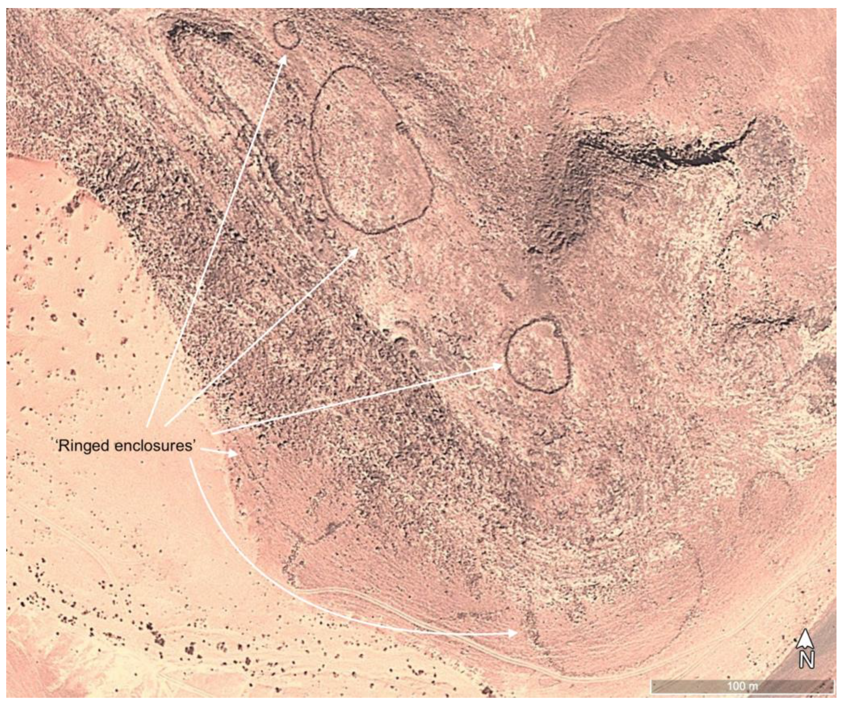
A little-understood form of structure termed ‘ringed enclosure’ (
Figure 6), defined by an earlier survey of the Neom development area [
6], and separately termed niched enclosures by Fujii [
21,
22], was identified across the survey area. These structures (
n = 45), sometimes occurring as clustered groups, consist of sub-circular walled enclosures, in some cases with an internal diameter more than 100 m, with a cairn or other small structure built into the enclosure perimeter. The largest examples and clustered groups were recorded in the south-west corner of the survey area, but other possible examples were documented across the rest of the study zone. In smaller examples of this monument type, the interpretation certainty was lower as these features were visually comparable with small agricultural/pastoral enclosures found across the survey area.
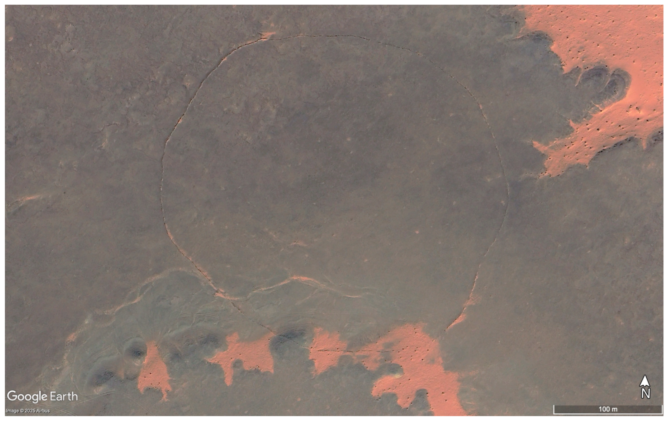
Two examples of possible ‘large circle’ features, sub-circular walled enclosures with a diameter greater than 200 m, were recorded in the central section of the study area (
Figure 7). A full perimeter could not be defined in either of these cases, and no relative stratigraphy could be defined with other feature types to indicate potential date ranges for these features. These structures may be part of the same phenomenon of large circle structures identified in Jordan and Syria [
23,
24].
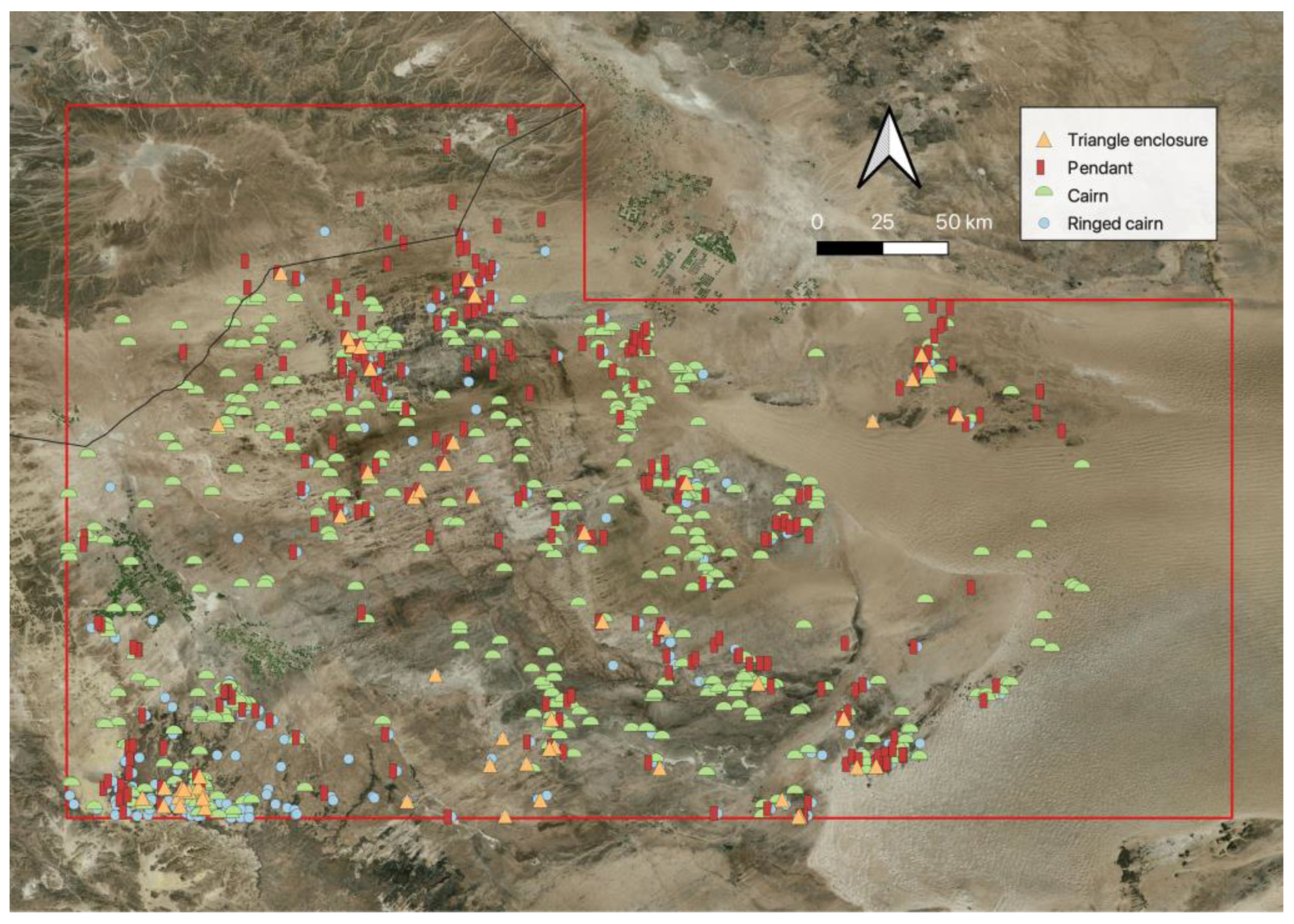
Simple circular cairns (
n = 595) formed the most common form of potential burial structure across the survey area, with a distribution across all but the northern and eastern margins of this zone (
Figure 8). In some cases, they were recorded as part of ringed enclosures discussed above, while in other examples, they may be small structures misinterpreted or later reconstructed as cairn stone mounds. More complex pendant structures (elsewhere termed ‘tombs with tails’ or ‘crenelations’) or clusters of pendants (
n = 269) were recorded across much of the survey area. Ringed cairns were recorded in similar numbers (
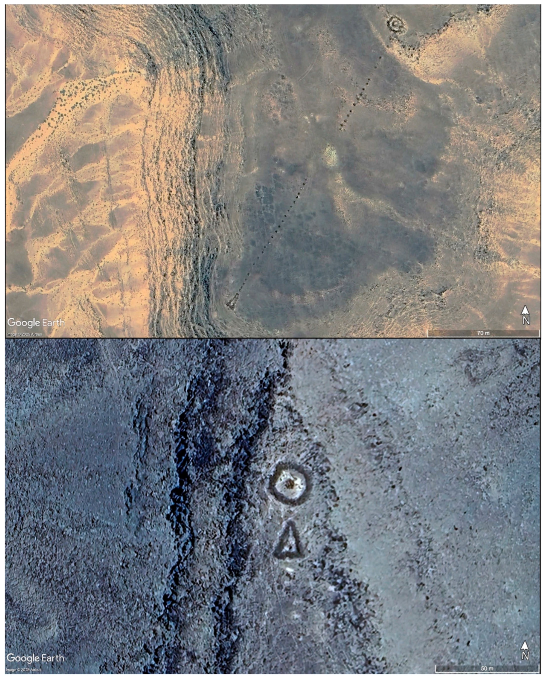
n = 295), but geographically with a notable concentration in the south-west corner of the survey area. In many cases, the ringed cairn and pendant formed part of the same structure where they occurred together, with the ringed cairn forming the ‘head’ of the pendant. In some examples ringed cairns were also associated with triangular walled enclosures (
n = 55), most frequently in the south-west corner of the survey area, but with a lower density spread to the north and east (
Figure 9).
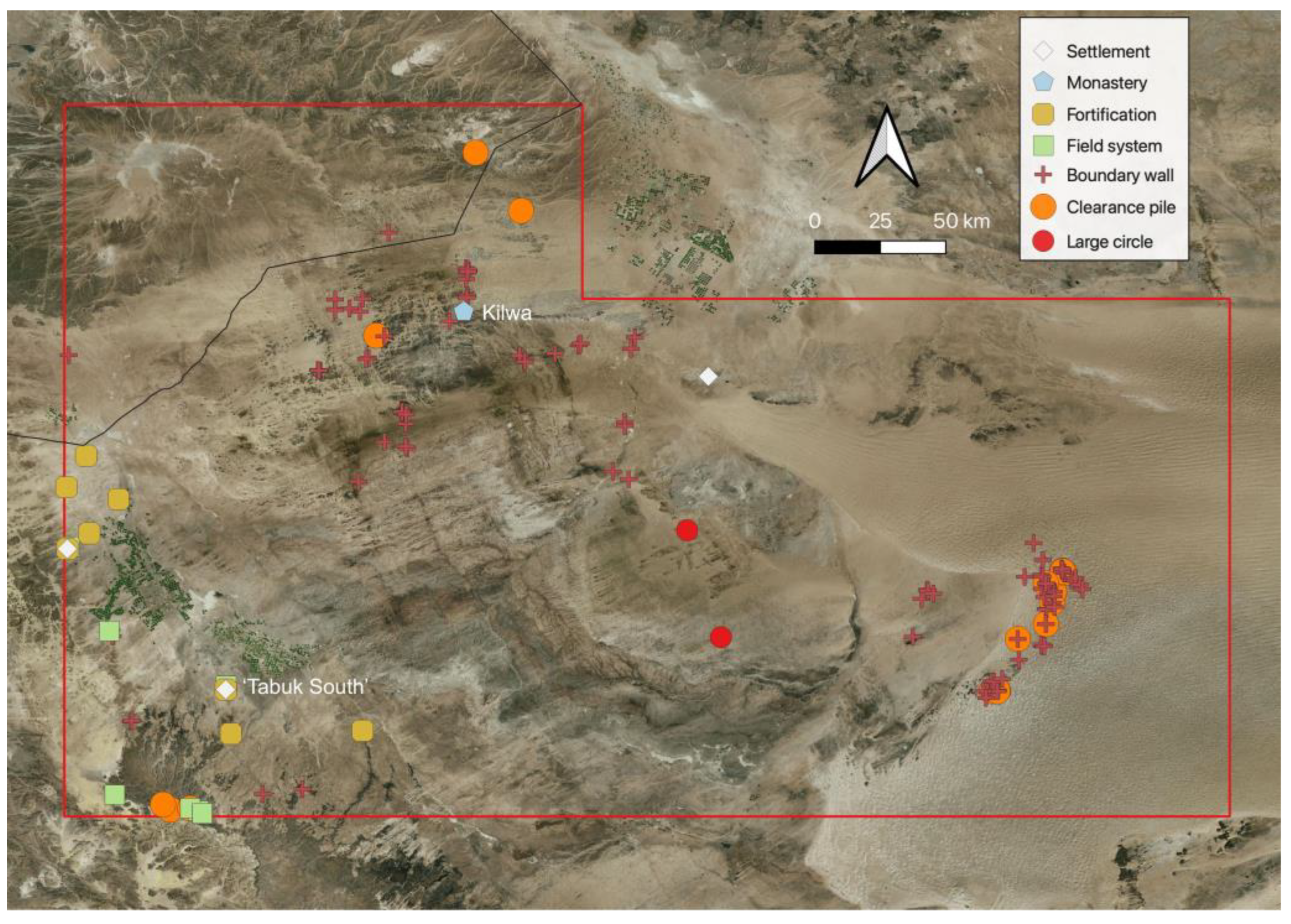
In terms of the development of larger-scale settlement and agricultural development, the evidence collected is concentrated along Wadi Tabuk (
Figure 10). This includes the walled oasis settlement of Qurayyah, as well as a comparable smaller enclosed field system without evidence of a corresponding settlement about 38 km to the south-east. A more notable identification is a walled settlement and possible field system elements, morphologically distinct from the evidence from Qurayyah, and located around 16 km south of modern Tabuk, and will be referred to throughout this paper as Tabuk South (
Figure 11). The site consists of a central sub-rectangular enclosure wall, most likely a fortified wall with traces of towers, measuring around 130 m by 100 m, with evidence of multiple rectangular structures in the interior. A second, potentially earlier, more curvilinear fortified wall runs around the southern side of this fortified settlement, measuring about 240 m by 100 m, with slight traces of internal structures. This may be an earlier fortified settlement or an adjoining ‘lower town’ element. From the south-east corner of this second fortified wall, traces of a wall run off to the south-east for about 310 m and continue south for around 190 m, with another short section of wall running around another 190 m to the west. In addition to a range of cairn structures, particularly on the plateaus to the east, south, and west, other notable elements include traces of a large, step-walled enclosure wall and other structures and embankments 750 m north east of the main citadel, potentially another settlement area or part of a field system (
Figure 12). A dense concentration of possible enclosures and several overlaying wall embankments were also identified 1500 m north of the citadel that are likely connected to this settlement landscape, although the exact interpretation of these is not clear.
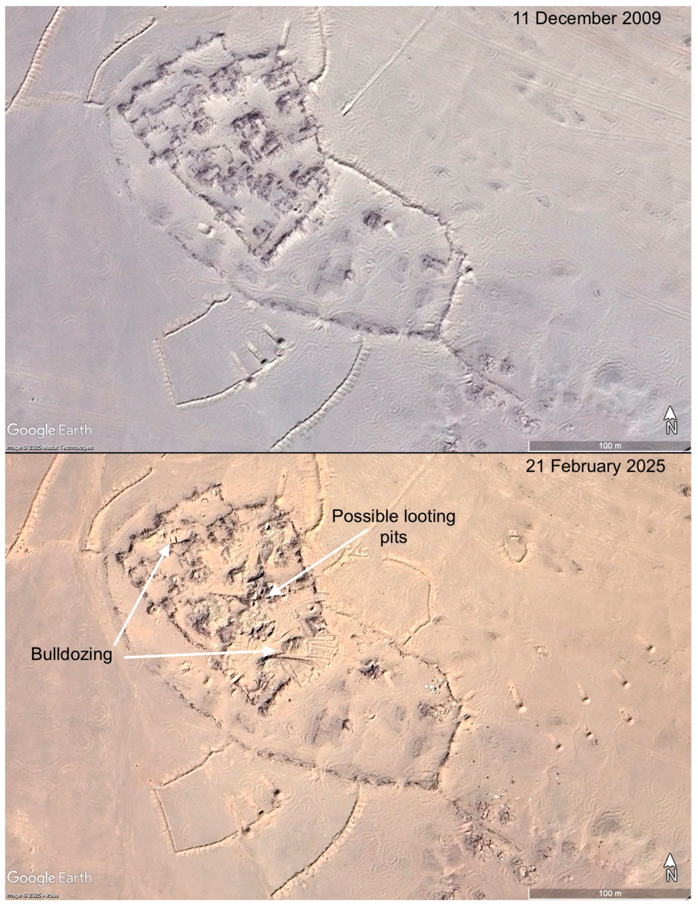
That this large standing complex had not previously been documented, despite its proximity to Tabuk and a main highway, may be due to its location within a modern military training area that has likely limited public access. Unfortunately, monitoring of the site via satellite imagery covering the past two decades has demonstrated that the primary settlement area has suffered repeated damage issues. The earliest available satellite image from 9 August 2004 shows that the site had already been affected by the construction of military embankments along the edge of the visible site. By 11 December 2009, a number of new military redoubts, emplacements, and embankments were constructed around the edge of the site. Possible looting pits appear on the site between 21 March 2013 and 22 July 2014, which suggests that the site was being intentionally targeted for the theft of antiquities. At some stage between 22 July 2014 and 30 August 2015, there is evidence of limited bulldozing or mechanised excavation scrapes appearing in the centre of the citadel, followed by more possible looting pits between 30 August 2015 and 7 October 2016, and new dirt tracks cutting across the site between the latter date and 3 November 2011. More possible looting pits appear in the centre of the citadel between 4 November 2017 and 3 February 2018. The first of two small temporary enclosures, possibly for pastoral herding, appears on the edge of the site between 30 May 2018 and 18 July 2018. A second temporary enclosure appears between 11 August 2018 and 29 September 2018, alongside a significant increase in the level of bulldozing, including the partial demolition of the southern wall of the citadel structure. The two temporary enclosures appear to have been abandoned by 21 February 2019, and a smaller herding unit appears on the east side of the citadel site on imagery between 18 October 2020. Finally, a small structure, possibly some form of mast, appears in the interior of the outer wall between 22 April 2022 and 24 April 2024. Imagery analysis has, therefore, demonstrated a significant decline in the condition of this large, undocumented site, particularly over the past decade.
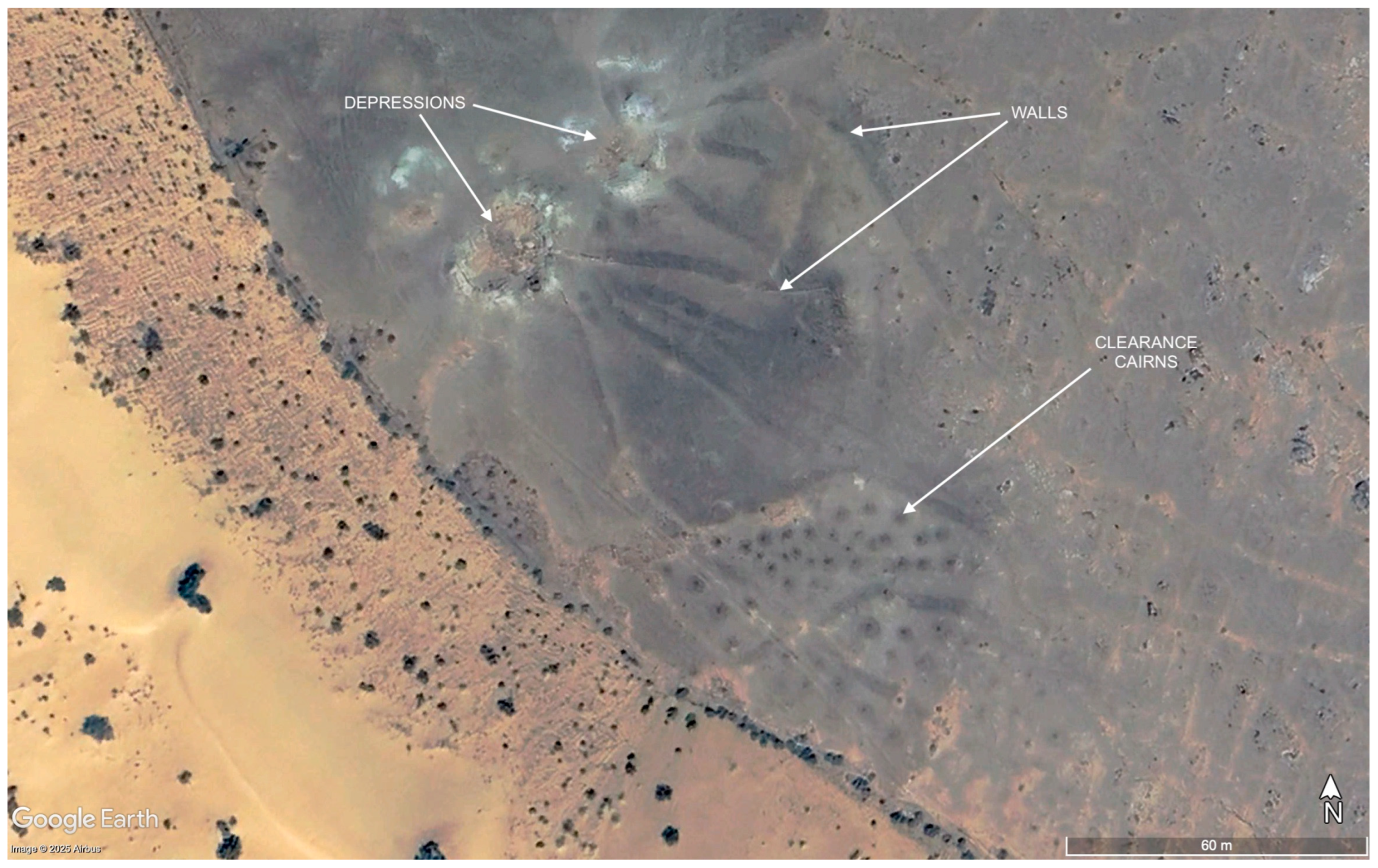
Another unexpected element identified on rock outcrops on the edge of the Nafud desert in the south-eastern section of the survey area was a series of meandering stone embankments and clearance piles (
Figure 13). While not classified as field systems, it is possible these complexes were developed to encourage localised vegetation growth, with stones cleared to open up limited soil bases, with some of the stone walls may have worked to guide any moisture into these zones and, in some cases, toward natural hollows. There is no associated evidence to suggest the date of these complexes, and across these rock outcrops, there are only a small number of other features, such as simple stone cairns and stone wall enclosures. At the southern end of these rocky outcrops are a number of mustatil, ringed enclosures, pendants, and ringed cairns.
Finally, similar to the distribution of visible settlements and field systems, the only fortifications recorded were in the vicinity of Wadi Tabuk. These include the fortifications and walled settlements at Qurayyah and the newly identified Tabuk South site, and a small fort at Qal`at al Akhdar.
5. Discussion
The systematic optical analysis of satellite imagery across the survey area allows a range of preliminary interpretive models of human occupation and activity to be developed for this region, providing a baseline dataset for the future management and research across these landscapes. For instance, it enables a broad perspective on concepts of connectivity and indigeneity in terms of the concentrations and spread of forms of monumental architecture. Recent discussion on the earlier prehistory of Arabia, focusing on tool assemblages and more broadly on animal domestication, has highlighted the importance of indigenous technological developments, alongside external input of populations, materials, or knowledge from other regions, notably the Near East and East Africa [
25]. How monumental traditions fit in or contrast with these material culture and faunal assemblages offers a model through which this landscape on the periphery of the Near East can be examined.
Beginning with the distribution of larger star-shaped kites and mustatil structures, where recent excavations have so far consolidated a later Neolithic-adjacent chronology, it is possible to interpret a continuation of a minimal overlap of the two feature types as identified in the eastern Nafud [
7]. In the latter, apart from a limited spatial overlap around the Ha’il region and including a single example of a mustatil overlying an earlier kite structure, the distributions of the two site types were distinct, with mustatil roughly to the south and kites to the north. This spatial contrast can be further developed in the western Nafud zone, where an even clearer distinction is visible between the star-shaped and associated kite types and the smaller V-shaped kites recorded in the south-western section of the survey area.
Previous studies had already noted that these site types were spatially distinct, but this new survey demonstrates what a clear barrier the Wadi Tabuk forms between the two types. It is not possible to explain why the two forms are so spatially distinct, particularly as there is no comparable dating evidence for the smaller V-shaped structures to demonstrate they were contemporary. The two sides of the Wadi Tabuk are geologically and topographically dissimilar, with the south-western side markedly more mountainous and geologically mixed, which may have influenced this situation. It should be noted that some of the kites to the north east occupy similar topographical positions along the slopes of small hills.
The identification of these V-shaped kite forms adds to the distributions recorded to the south in the AlUla region [
20] and in the Neom development zone [
6]. This would seem to confirm that this monument type was more numerous in north-west Arabia than in Sinai and Negev regions, where they were first identified and often appear to utilise breaks of slope and more mountainous terrain to hide the ‘head’ of the kite. This may have important implications for the future study of this structural type, where recent studies centred on the Negev remain largely ignorant of the large number of V-shaped kites to the south-east, viewing them instead in terms of local Timnian culture [
26]. In terms of the limited scientific dating available, the V-shaped kite seems to be mostly placed in the fourth and third millennium BC, although recent OSL sampling of the site of Nahal Eshel in Israel suggests the kite was in use as early as the sixth millennium BC [
27].
The V-shaped kite distribution extends over the western terraces of the Wadi Tabuk, unlike the star-shaped variants, which were located at least 50 km east of the central wadi channel. In terms of at least potential relative dating, the identification of several possible V-shaped kites located close to or possibly incorporated into sections on the periphery of the walled oasis of al-Qurayyah [
13]. This context may be particularly fruitful for further investigation of this kite type, given its proximity and possible stratigraphic relationship with the wider al-Qurayyah complex.
The spatial distinction between these two broad kite forms and the mustatil structures is made more complex by the apparent chronological range that has been identified through limited scientific dating of these types. A combination of C14 and OSL dating of star-shaped kites located within the survey area has produced a potential date range of from the late ninth millennium BC through to the early sixth millennium BC [
16,
28]. The growing corpus of scientifically dated samples from larger mustatil structures has so far produced construction dates in the later sixth and early fifth millennium BC, with some examples of later re-use.
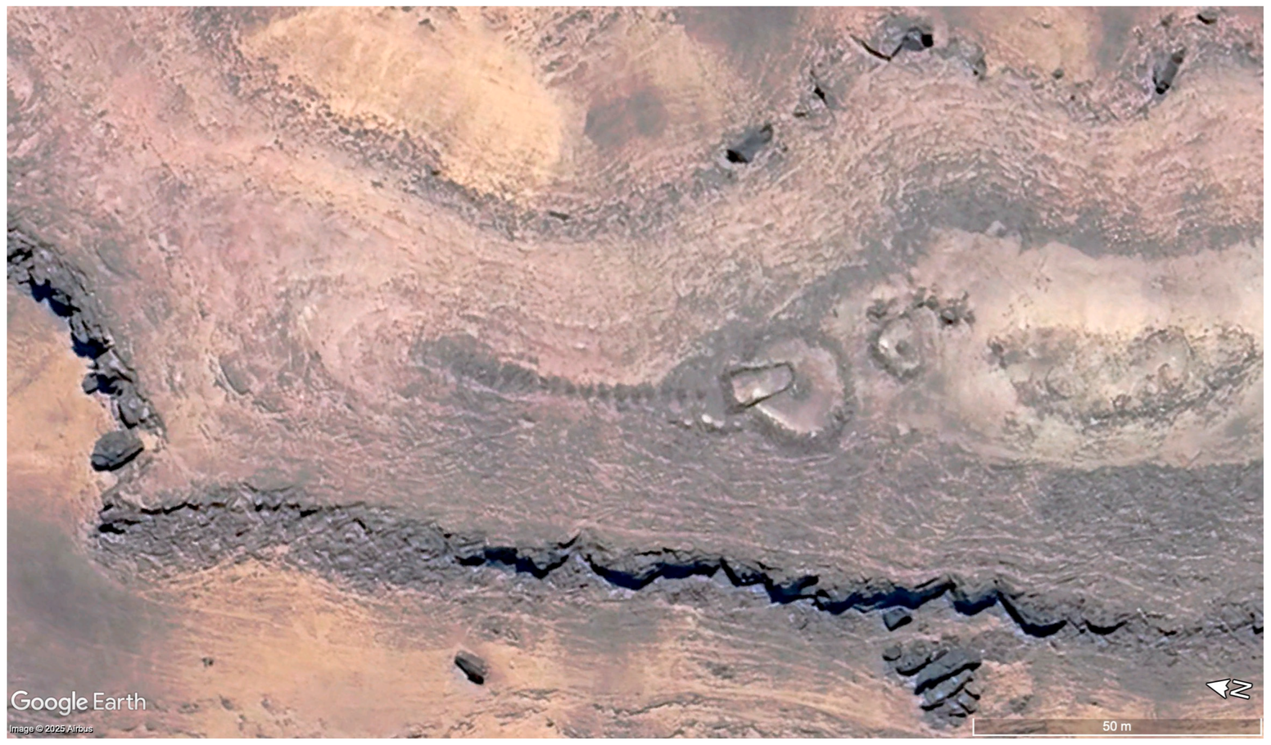
The small mustatil-type structures are more difficult to confidently identify on satellite imagery as they are comparable in scale to small sub-circular walled enclosures. This issue is particularly relevant in the case of one possible small mustatil recorded that overlies a ringed cairn/pendant combined structure (
Figure 14). While it is essential that the site is validated on the ground, if this identification is correct, it would provide stratigraphic evidence that at least the smaller form of the mustatil-type structures continued to be built at least into the Bronze Age, when the pendant and ringed tomb structures are first currently dated in the region.
Another potentially early feature recorded was the ‘ringed enclosures’ previously identified in the Neom survey zone. This phenomenon of a walled enclosure with a single cairn or other structure in its perimeter continues only a little further into southern Jordan, with small-scale examples also found extending into central Saudi Arabia. Investigations of a group of smaller types of these structures by Fujii [
21,
22] noted the recurring position of the structure or niche on the eastern side of the enclosure, suggesting a ritualised architectural form, and posited a Chalcolithic date for these monuments, although more detailed investigation and dating evidence are needed to confirm the latter. They may also be comparable to the smaller open-air sanctuaries recorded in the Negev desert, most clearly with Avner’s Type 3d [
29]. However, the Neom zone appears to be an epicentre of this tradition, if it is a single connected architectural grouping, with clusters of larger examples sometimes more than 100 m in diameter found in the southern section of the survey area. This distribution predictably continues into the south-western section of the current survey, although smaller isolated examples were recorded across the survey area. These new examples provide little new information on the function or date of these structures, although, as in the Neom zone, there was no relative dating visible of them overlying earlier site types. At this stage, it can only be conjectured that these sites may have functioned as communal meeting points, possibly for dispersed pastoralists in a manner comparable to recent interpretations about the use of mustatils in the late Neolithic [
1].
Even more enigmatic are two ‘large circles’, sub-circular walled enclosures over 300 m in diameter. These two dispersed features are located towards the centre of the survey area, with only part of the perimeter of the southern example visible. There is no evidence of any internal features or any relative stratigraphy in relation to any other site types. A possible comparison can be drawn with the large circle features previously identified in Jordan, Syria, and Turkey [
23], although these features remain equally poorly understood. Although little can be drawn based on two identified examples so far, they do fit within a north–south distribution through north-western Arabia postulated by David Kennedy based on the sites he recorded in Jordan. Recent OSL dating of this site type in Jordan has suggested a mid-2nd millennium BCE date of construction [
30].
The primary cairnform structures recorded, namely singular cairns, ringed cairns, and pendants, were recorded across the survey area. While the current understanding of the chronology of simple cairns could place them anywhere from the Neolithic to the pre-Islamic, regional excavation work in Saudi Arabia on the pendant and ringed cairn forms has indicated that they were built from the third millennium BCE through to the second millennium BCE, with possible re-use continuing through into the first millennium BCE [
31,
32]. Contrasting evidence from eastern Jordan on comparable monuments has recorded what are interpreted as primary burials through into the later first millennium BCE [
33,
34]. This highlights the need for more absolute dating of these site types over a broader geographical area to better understand the use and reuse of this monumental form. We can at least assume that pendants and ringed cairns had emerged as an architectural form in northern Arabia by the third millennium BCE.
Broad trends are identifiable, such as a predominance of ringed cairns to pendants in the south-west and a converse higher concentration of pendants to the north. One interesting trend identified in the Neom survey zone was the occurrence of ringed cairns combined with triangular-walled enclosures at the southern end of the survey area. While this was paralleled in the small area west of the Wadi Tabuk in the current survey area, to the east, a dispersed spread of this type or alternative forms also incorporating a pendant element was recorded in a range of locations. Beyond the present research, an initial survey to the north east of Wadi Sirhan would suggest that the triangle enclosure component does not continue into this region, while the number of ringed cairns relative to pendants is lower.
The main evidence of substantial settlement and agricultural activity was confined to the vicinity of the relatively well-watered Wadi Tabuk. The identification of a substantial walled fortification and probable settlement provisionally titled Tabuk South represents a significant new discovery in the region, even if at this stage the date of occupation can only be speculated. Morphologically, it has no explicit parallels with the dated ancient settlements at Hegra, al-Khuraybah, or al-Qurayyah in the wider region of Tabuk, beyond the relative rectilinear form of visible structures and the settlement perimeter walls. There may be two distinctive phases of occupation as evidenced by the semi-circular perimeter wall visible on the south-west side of the site, although it is not explicitly clear from the satellite imagery available which phase may be the earliest. It is conjectured that the settlement, supported by an extensive agricultural system, may be pre-Islamic or possibly be early Islamic in date, and possibly a precursor to modern Tabuk. One notable point from a landscape perspective is that the density of identified cairns, pendants, and ringed cairns in Tabuk South is significantly higher than around modern Tabuk or al-Qurayyah, as well as the Wadi Tabuk within the survey area, suggesting that this landscape may have been of some importance in earlier prehistoric periods.
While Tabuk South, Tabuk, and al-Qurayyah are in the relatively well-watered landscape of Wadi Tabuk, a final potential substantial settlement was also identified in the eastern section of the survey area. Unlike the former, this site does not appear to have been supported by any form of associated cultivation. Consisting of a dense cluster of stone enclosures built across a south-facing slope, there is little morphologically to distinguish the individual cells from the singular or small clusters of enclosures found across much of the survey area. Based on this limited evidence, it is speculated that this ‘settlement’ may be an undated permanent or semi-permanent central place for pastoralist groups in the region.
More broadly, and in conjunction with the evidence from the surveys of the eastern Nafud and Neom development zones, it appears that investment in monumentality across the arid zone of northern Arabia does not continue beyond the Bronze Age. Instead, we see an increasing gravitation in activity towards the better-watered landscapes, in this case study, the settlements and agricultural systems of the Wadi Tabuk, and without a clear monumental vocabulary. This is not to suggest that the extensive arid zone was abandoned in this later era, as the vast swathe of stone-built corral structures would appear to indicate continuing pastoralism and transhumance across this landscape. There are also distinct anomalies, such as the monastic site of Kilwa in the northern section of the survey area. But as a broader, general trend, the forms of major monuments that are so visible across the landscape in the Neolithic and Bronze Age, such as kites, mustatil, pendants, and ringed cairns, are not matched by comparable structures in subsequent periods.
This conjectural model is put forward, aware of the current limited dating visible for many of the site types discussed. For many of these monumental structures, only a small number have been scientifically dated across the hundreds and thousands dotted across the Arabian Peninsula, although many of these multiple site dates are relatively consistent across type. In the case of structures like the ringed enclosures, where there have been no identified archaeological excavations or dating, the current hypothesis is that despite the scale of these structures and the density of clustered examples, there is no relative dating evidence of these sites overlying any other archaeological structure. Alongside this, the incorporation of a cairn-type structure into the perimeter would suggest that these are an early site-type within the landscape, but like so many elements within this model, it requires further qualifying evidence on the ground.
It is also possible that smaller structures that may fall within a monumental bracket that are not as easily identifiable as part of a rapid remote-sensing survey, but the absence of structures beyond the Bronze Age of comparable scale is telling. An exception is possibly the advent of the ‘large circle’ structures, where recent dating from Jordanian examples has placed the structures in the second millennium BCE, but only two examples were identified in the current study area, and only a small number overall across northern Arabia, so not comparable to earlier examples of regionally dominant monumental architecture.
If these trends away from monumental architecture in the arid zone are a genuine phenomenon, there may be several factors driving these changes. It may be that this is just a change in cultural practice in the region, although it is notable that while the re-use of Bronze-Age monumental tombs in the first millennium BCE is recorded regionally, there does not seem to be any development of an original, distinct monumental form in funerary or social practice. Environmental drivers may also be relevant, particularly if increasing aridification and desertification reduce the capacity of the region to sustain mobile or pastoral communities and their herds, thus reducing the ability of communities to invest surplus economy into monumental architecture. The spread of Bronze Age monumental architecture, such as pendants and ringed cairns, could even be framed as preceding this drop off, being used by familial or tribal units as a common language to state territorial claims as environmental pressures on pastoral viability increased. From a broader perspective, it could also reflect the growing dominance of the fertile regions of the Levant and Mesopotamia, and possibly Yemen, in dominating regional economies to the detriment of the arid zones.
