Article

Climate Change and Historical Food-Related Architecture Abandonment: Evidence from Italian Case Studies

by
Roberta Varriale
1,* and
Roberta Ciaravino
2
1
Institute for Studies on the Mediterranean (ISMed), National Research Council (CNR), 80134 Naples, Italy
2
Research Centre for Agricultural Policies and Bioeconomy (CREA), 00187 Rome, Italy
*
Author to whom correspondence should be addressed.
Heritage 2025, 8(10), 423; https://doi.org/10.3390/heritage8100423 (registering DOI)
Submission received: 30 July 2025 / Revised: 17 September 2025 / Accepted: 2 October 2025 / Published: 5 October 2025
(This article belongs to the Special Issue Sustainability for Heritage)

Abstract

Climatic factors have always played a key role in the construction of food-related architecture: mitigation of outdoor temperatures or winds, adoption of raining waters in the productive processes, etc. However, sometimes, climate change has impacted the profitability of those structures and eventually caused their abandonment. Today, historical food-related architectures are significant elements of local rural heritage, and they are also tangible symbols of all the values connected to the corresponding typical food productions. When the cultural value of rural cultural assets and the historical management of climatic factors coexist, this potential can be investigated, and the results can ultimately be included in the corresponding enhancement processes. To exploit this potential, the paper introduces the theoretical concept of food-related architecture as climatic indicators, with reference to the changes in the climate that have occurred during their construction, as well as their abandonment. According to the thesis of the research, the adoption of the concept of climatic indicators can implement the value of selected minor cultural assets, support sustainable rural regeneration plans and integrate missing historical climate series and data. In the Materials and Methods section, two theoretical charts have been introduced, and the pyramid of the Mediterranean diet was analyzed to allow for the selection of some food-related architectures to test the theoretical approach developed. Then, three Italian case studies have been analyzed: the concept of climate indicators was tested, and some potential focus points of actions connected to this aspect were elucidated. The case studies are the Pietragalla wine district in the Basilicata Region, the Apulian rock-cut oil mills and Mills’s Valley in the Campania Region.

1. Introduction

Climatic and territorial features—together with local skills, available technologies and cultural and intangible values—have always characterized various forms of architecture. When referring to structures built to support some phases of production, the transformation or the conservation of historical food specialties, the concept of food-related architecture can be introduced. Food-related architecture influenced production outcomes, drove economic and social development and, very often, represents today significant tangible and intangible cultural heritage elements, contributing to a strong sense of local identity.
This is a very common issue, especially in countries where food specialties are intangible values of local cultural heritage. In Italy, where the relationship between food specialties and local culture is so strong that its Mediterranean diet—together with the Spanish, Greek and Moroccan diets—was inscribed in the UNESCO Intangible Cultural Values List in 2010 (subsequently updated with the inclusion of Cyprus, Croatia and Portugal in 2013 [1]), many food-related architectures are representative of the Italian contribution to the inscribed cultural value. Olive oil, wine and durum wheat pasta are the pillars on which that inscription is founded, from the Italian side. These traditional ingredients make up the basis of the national diet in any regional declination, and related historical food-related architectures can be considered as cultural assets, namely those tangible elements that represent the intangible values inscribed on the UNESCO list.
Today, historical food-related architectures are at the core of several enhancement projects, both in the touristic sector for the sustainable development of rural areas [2,3,4] and in the promotion of the corresponding production. In fact, they can support the vertical diversification of economic activities in rural areas, and they can also be adopted in marketing strategies for the agri-food sector, especially in reinforcing the relationship between art and food for the benefit of strategic branding, above all, for the exports [5]. Since their potential has not been fully exploited yet, their significance must be highlighted to enrich their interpretation. The introduction of new elements for their interpretation can support both their enhancement as elements of rural cultural heritage and rural regeneration plans as well.
Along with the study of architecture style and of materials used for their building, the reconstruction of connected issues and intangible values can also support those efforts. Since food-related architectures are the result of the maximization of local opportunities, available technologies and logistic factors—while minimizing or overcoming several obstacles at the same time—information regarding these aspects can also highlight their significance.
However, the factors that led to the construction of those structures can contribute to their interpretation as much as the factors that caused their decommissioning. In fact, not all those factors are fixed, many are susceptible to variation throughout history, and their variations can help place structures throughout their lifetime. Some of those changes are connected to technological updates, others to new scenarios in the sector which the corresponding productions belong to; sometimes, changes in the climate have also played their role. With reference to this last aspect, in many cases, climatic changes impacted the profitability of some architectures, originally planned to optimize local opportunities, causing their abandonment. When this happens, the history of those structures ends up reflecting those changes. Since one of the major critical issues in climate reconstruction from a long-term historical perspective is the lack of historical sources, what if the history of these structures can contribute to filling the missing gaps, and this character enriches their interpretation and provides new elements for their enhancement? Based on the above-mentioned considerations, the concept of food architectures as climatic indicators was introduced, focusing on the following climatic issues: changes in temperature and rainfall patterns.
The research is based on the hypothesis that several food-related architectures, built to face climatic issues or to maximize the effects of local climatic factors, today, even if abandoned, are significant elements of local rural cultural heritage, whose interpretation already supports local food specialties and rural regeneration projects. The thesis of the research is that, since these structures were abandoned as an effect of climatic change, their significance as climatic indicators can be adopted to implement their interpretation for the social and economic benefit of local populations.
The research consists of the following three sections:
  • Materials and Methods. Sources are listed and methodology is illustrated. Methodology consists of two subsections:
    • The theoretical concept of climatic indicators, as an answer to some environmental history questions, is introduced, and the tools elaborated for the analysis of case studies are illustrated.
    • The Italian pyramid of the UNESCO Mediterranean diet is introduced, and the connection between food-related architecture and corresponding food specialties is established.
  • Results and Discussion, where case studies, selected based on their significance within Italian foods listed in the UNESCO Mediterranean Diet, are studied. The selection was carried out by highlighting some architectures that supported the production of the most iconic Italian food specialties: olive oil, wine and wholegrains. Each case study was analyzed in a separate subsection. In each of them, climatic factors connected to the building and abandonment of the corresponding case study are analyzed, also adopting the introduced tools. In the final part of each subsection, the state of the corresponding enhancement processes is studied, and some focus points for their interpretation, based on their potential as climatic indicators, are listed. Then, results from previous analysis are discussed and summarized. Results are reported in a table which together with two charts, is part of the toolkit provided to support future analysis regarding the relationship between food-related architecture and climate change at a global level.
  • Conclusions, where a summary of the research results is given.

2. Materials and Methods

Research was carried out by adopting an innovative theoretical approach, elaborated by the authors by picking up various elements from different sources and tools, also by crossing data of a heterogeneous nature and introducing two interdisciplinary methodological charts. The main sources were as follows:
  • Bibliographic data and research results from the literature regarding the historical reconstruction of climatic changes, history of technologies and local productions, reports regarding the history of selected case studies, descriptions of UNESCO properties from the UNESCO lists and UNESCO tentative list dossiers;
  • Data regarding the enhancement of rural cultural heritage from academic studies and institutional databases and websites;
  • Results from onsite inspections.
The methodology consists of two steps:
  • Food-related architecture and climatic factors are introduced as a resource for environmental history. This approach focuses on the lack of historical data series regarding historical long-term climatic changes and on the potential of some food-related architectures in covering this gap. This issue was addressed by introducing the theoretical concept of climatic indicators, and two charts were elaborated to test the potential of selected food-related architectures from this perspective. The first chart illustrates all the possible interconnections between food-related architecture and permanent and variable climatic factors. The second allows for the description of variations in the relationship between those artefacts and climatic changes, also introducing the variable of technological advancement. Finally, some examples from the international scenario are provided.
  • The second phase focuses on food-related architecture connected to the Mediterranean diet—inscribed in the UNESCO Intangible Cultural Values List—and on the so-called pyramid of the Italian diet: a graphical representation of the ideal combination of Italian food specialties listed in the diet. In this phase, different sources—bibliography, website data, institutional documents, etc.—were adopted. Then, a new graphical representation of the pyramid was introduced: symbols of food-related architecture have been added in correspondence to those specialties located at the base of the pyramid and suggested for daily use. Their role as elements of the rural cultural landscape in Italy is also introduced, with a special focus on the relationship between the theoretical concept of nature and climatic changes.

2.1. Food-Related Architecture and Climatic Factors

The study of climate change from a historical perspective is a very complex issue. Although evaluating climate change would require the analysis of continuous historical series produced using uniform measurement tools and metrics, this is not always possible from a long-term historical perspective. In the Mediterranean regions, “currently available data not only provide a rough idea of the potential of climate proxies to reconstruct climate variations at a local scale but also stress limitations to sufficiently reconstruct the full range of natural climatic variability, including interannual to multicentennial variations” [6] and it was observed that “recovering eighteenth-century meteorological data series from scattered archives and publications is an arduous task, and the data quality is varied and often poor” [6].
When reliable historical series are not available, attempts have been made to replace so-called direct sources with indirect sources. This approach has already been successfully applied in some environmental history studies, in which indirect methods have been used to highlight climate change in the past, with “the introduction of infrastructure” as an indicator of climatic conditions and changes [7].
In accordance with this methodological approach, commemorative marble tomb stones in memory of catastrophic historical landslides [7], bridges and mills located on rivers that are now dry due to the extinction of glaciers, marks left on the walls of historic buildings following floods, snow cellars built at altitudes where it no longer snows, etc., were also considered as indicators of climate change that has occurred between the time of their construction and their abandonment.
This approach can be particularly relevant if adopted in the case of rural food-related architectures, which themselves are expressions of specific climatic conditions. In fact, the management of environmental issues by adopting architecture skills is a very common phenomenon, which also includes the use of available technologies for the maximization of given climatic opportunities and the minimization of climatic linkages. Solving these critical issues has been a priority throughout history at any latitude, and those structures not only impacted the survival of the settlements themselves, but they also ended up acquiring identity values for local communities and landscape identitarian characteristics as well. In addition, the link with environmental issues is particularly significant in terms of intangible values for local communities and impacted local rural social and economic development as well.
However, the combination of local agricultural production and food-related architecture is not always static: sometimes climatic changes have affected the ability of those architectures to perform the role for which they were built, and they have eventually been decommissioned.
Since, as already mentioned, it is almost impossible to reconstruct long-term historical climate series in rural areas, and those structures are often minor in scale, scattered throughout the territory and above all, belonging to private rural estates, there is no reliable data on their construction and decommissioning. The lack of these values makes it impossible to study the correlation between climatic phenomena and the life of these buildings and, for this reason, rather than adopting traditional parameters, the concept of climate indicators applied to food-related buildings has been introduced in this research.
According to this concept, the very existence of certain architecture designed to manage specific climatic factors or to take advantage of natural resources is an indicator of the fact that, at least at the time of their construction, climatic conditions were compatible with them. Similarly, their abandonment, net of technological advances, is a sign that those climatic conditions have changed.
Since it is not always possible to establish a causal relationship between the abandonment of rural architecture and climate change, even the study of current climatic conditions—incompatible with their functioning—can support the thesis that, in the period between their construction and today, climatic changes have occurred.
But to which types of architecture can this principle be adopted? And, above all, is it possible to establish a connection between the various expressions of climate change and the various types of food-related architecture?
Following the articulation of environmental factors provided by P. D. Sharma [8], they can be divided into two groups: climatic factors and topographic/physiographic factors.
Figure 1 starts with a graphical illustration of this definition implemented by the results of previous studies regarding the classification of subsequent articulations of primary climatic factors. Then, all possible interactions between climatic factors and food-related architecture have been introduced at a theoretical level.
Starting from the upper part of the chart:
  • The first group includes fixed climatic factors: latitude, longitude, altitude and exposure.
  • The second group includes variable climatic factors: temperature, solar radiation, wind and water resources from renewable and meteoric sources.
The research focuses on the impact of the second group of factors and their connection with some food-related architectures.
As summarized at the bottom of Figure 1, several critical issues or opportunities are related to the management of each climatic factor. All these instances have been managed throughout history with the construction of dedicated architecture; they can be organized into the following four groups:
  • Temperature: cellars, heat-insulated factories, warehouses, etc. [9].
  • Solar irradiation: processing of products and their drying, either using removable structures—typically made of wood—or using the roofs of built architecture.
  • Wind: drying [10,11] of certain foods and its use as an energy source. Examples of this type are the mobile structures used for drying fish in northern Europe [12,13] and the windmills used in wheat milling.
  • Water: irrigation of crops and use as an energy source. In both cases, they are managed through the construction of dedicated structures: aqueducts, wells and canals in the first case and water mills in the second.
The scenario illustrated in Figure 1 highlights the interconnection between given climatic factors and the corresponding food-related architecture by adopting a static representation. However, when referring to variable factors, it is implied that those architectures and their functioning can also be influenced by their variations. In those cases, food- related architectures can be modified, dislocated or simply abandoned.
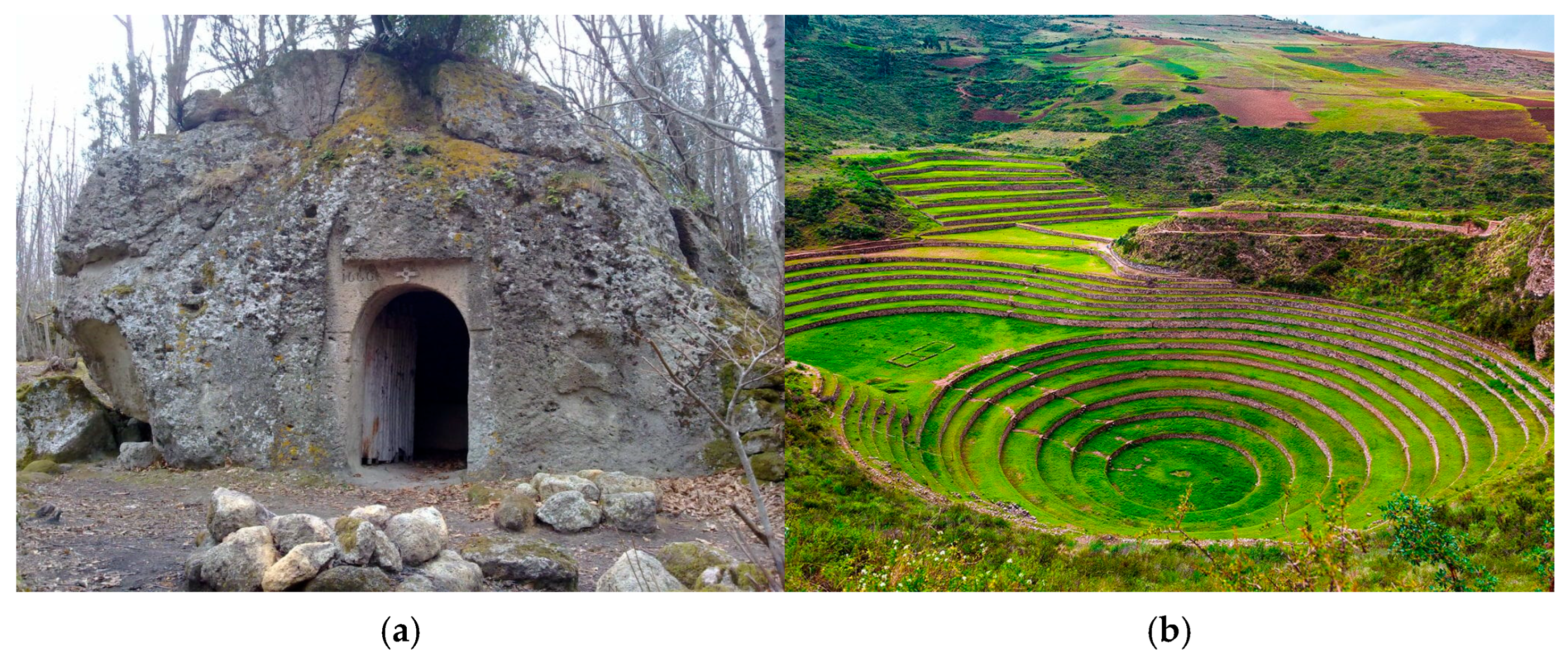
The phenomenon described is global, and therefore the scheme developed allows for the relationship between food-related architecture and climate change to be analyzed on a broad scale. With reference to the first group, ice cellars abandoned because of the rise in the level of snow altitude in southern Italy can be cited [14] (Figure 2a). With reference to the second, typical examples are the flat roofs adapted to dry fruits and vegetables that have become unusable because of the tropicalization of the climate [15], which has led to frequent, sudden heavy rainfall in summer in some areas on the southern shore of the Mediterranean. Architectural barriers built for the creation of microclimates belong to the third typology, those built by the Inca in the Sacred Valley of Cuzco in Peru can be cited [16] (Figure 2b). Finally, historical aqueducts, canals and cisterns whose supply was ensured by exhausted springs or rainfalls, like those of Jerusalem in Israel [17] can be cited.
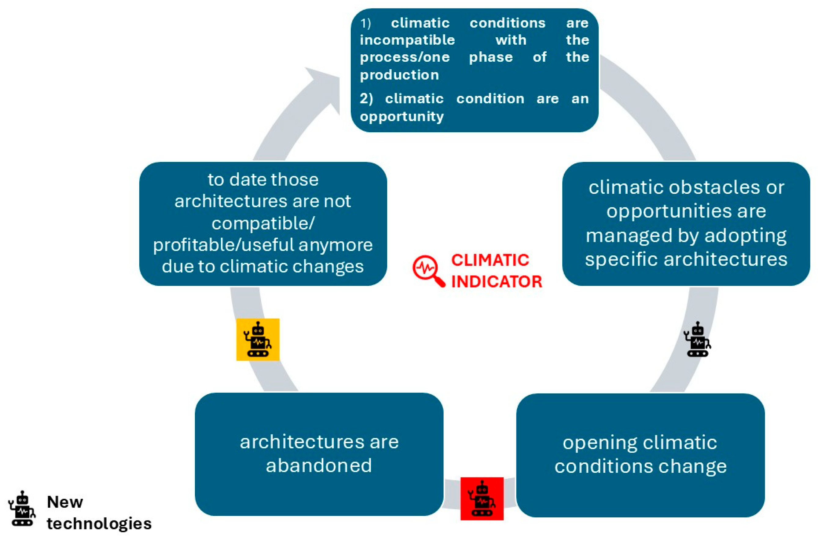
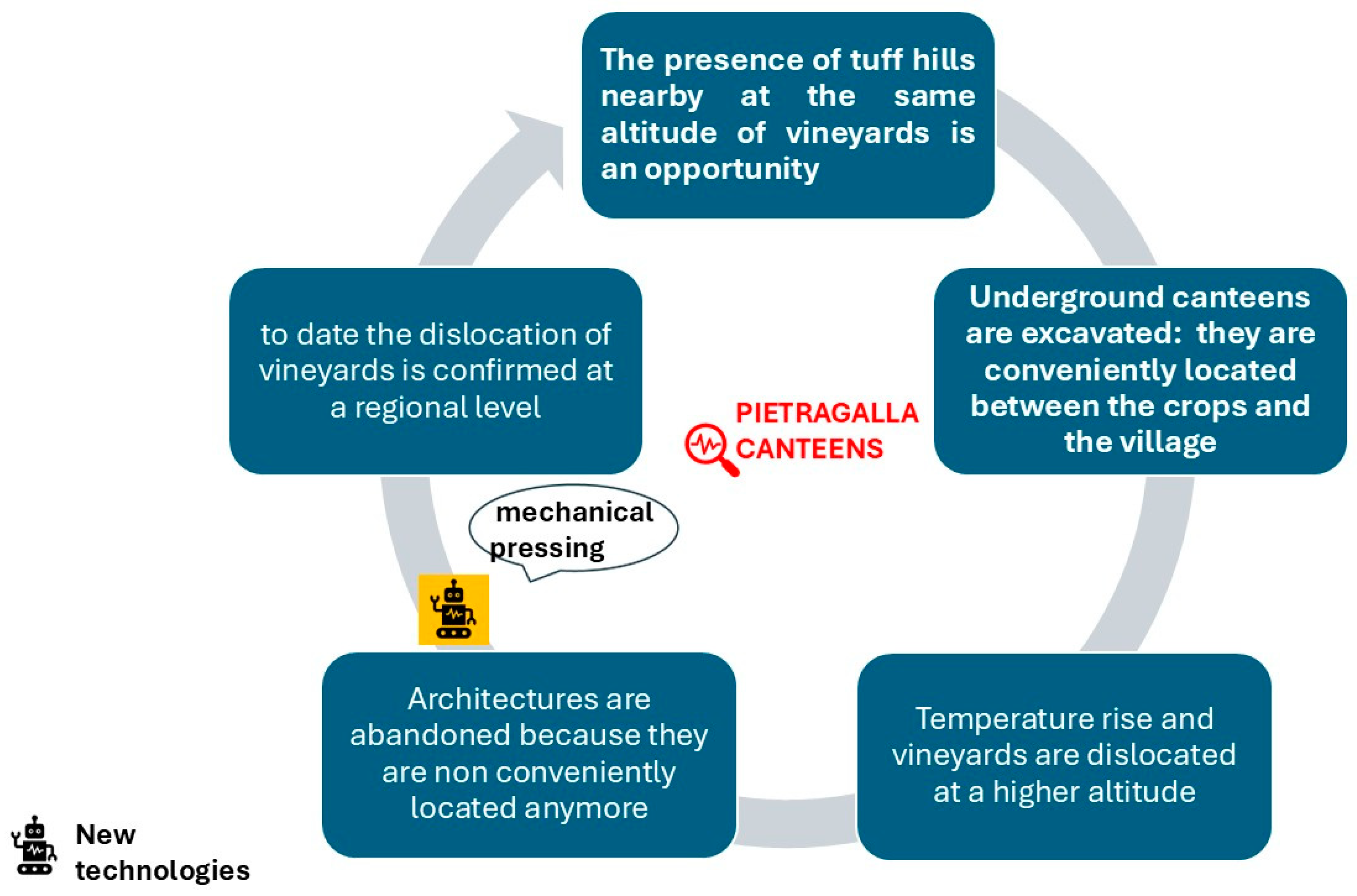
But is it possible to pass from archeological evidence to the definition of a theoretical concept with the potential to indicate climatic changes? To this end, the concept of food-related architecture as a climate indicator has been developed and a tool for interpreting this functional relationship was provided (Figure 3).
Figure 3 is the graphical representation of the vital circle of climatic indicators and of its significance. It consists of five steps:
  • The first phase refers to the initial climatic conditions: sometimes climate was an obstacle for the productive process, sometimes it was simply an opportunity to be exploited.
  • The second refers to the construction of food-related architecture that managed those climatic conditions, either by removing obstacles to production or by optimizing the opportunities provided.
  • The third refers to the most critical phase of this process, the change in the initial climatic conditions.
  • The fourth refers to the decommissioning of food-related architecture as an effect of changes in initial climatic conditions.
  • The fifth refers to current climatic conditions: when data on historical climate change are not available or cannot be cross-referenced and correlated with the abandonment of the structures under examination, even current climatic conditions, when compared with the characteristics of historical architecture, can reveal the changes in the climate that have taken place.
In this chart, the possible impact of new technologies was also evaluated. As illustrated in Figure 3, with reference to the possible technological interference in the life of these structures, there are three possible scenarios. In the first case (black symbol), technological progress occurred prior to climate change; in the second, it occurred between the climate change phase and the abandonment of the structure (red symbol); in the third, new technologies only became available subsequently (yellow symbol). While in the first case the cause of abandonment is exclusively the obsolescence of technology, in the second case, new technologies may have been a contributing factor to the abandonment, and in the third case, they had no influence whatsoever on the final decision.
By adopting the tools provided in Figure 1 and Figure 3, the theoretical concept of climatic indicators can be tested on selected case studies. Their adoption can also provide elements for the interpretation of those historical food-related architectures that are today considered rural cultural assets. In fact, today, they testify, on the one hand, to an attitude towards providing technical solutions to exploit the effects of climatic factors in the phase of their construction and, on the other, the loss of this character because of climatic changes.
From this point of view, these architectures can today also be considered as indicators of those historical climatic changes that occurred in the period that goes from their building to their decommissioning and to the present.
This aspect, which is always forgotten in the reconstruction of the values of historical structures, can enrich the system of values those structures are bearers of and has wide opportunities for use both in processes dedicated to their enhancement as cultural assets and as focus points on marketing strategies for connected productions.

2.2. Mediterranean Diet Pyramid and the Rural Cultural Landscape in Italy

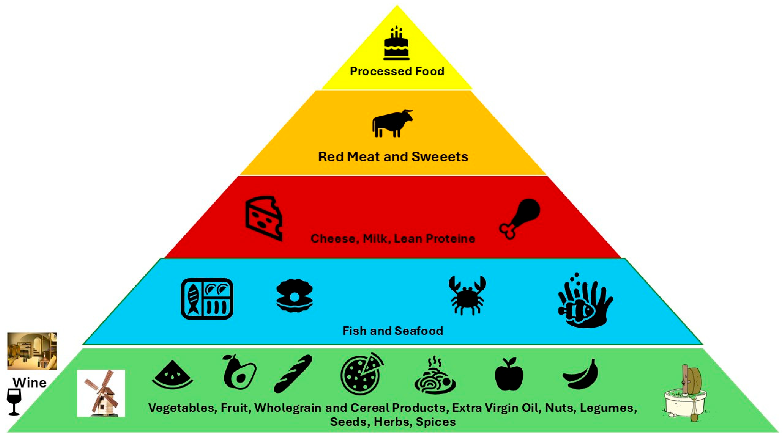
Italian food specialties represent the contribution of Italy to the UNESCO Mediterranean Diet [1,18,19,20], and the Italian diet food pyramid [21,22,23] is a hierarchical scheme that defines the ideal composition of the suggested weekly diet, both with reference to their nutritional and cultural values. At the top of the pyramid, processed foods, sweets and red meat can be found; their consumption is suggested as occasional. In the middle, white meat, cheese, local cheeses and fish can be found; in this case, their consumption is suggested daily, on an alternating basis. At the base of the pyramid, vegetable specialties, wholegrain products, cereals, olive oil and nuts, fruits and spices can be found; in this case, their consumption is suggested in all daily meals. In addition to these solid foods, the latest guidelines also include the daily consumption of limited quantities of red wine [24,25].
If we focus on the types of foods included at the base of the pyramid, they can be divided into two distinct categories: raw materials and food products.
While for the former, whose nutritional and organoleptic characteristics are linked to their seasonality, and consequently the only architecture possibly involved may be storage warehouses and cellars, for the latter, several traditional food-related architectures can be involved in their production.
Since “the Mediterranean Diet involves a set of skills, knowledge, rituals, symbols and traditions concerning crops, harvesting, fishing, animal husbandry, conservation, processing, cooking, and particularly the sharing and consumption of food”, as stated in the description of the UNESCO value [1], it follows that traditional food-related architectures built for their production not only characterize the corresponding food products, but, above all, they can well be considered as cultural assets.
Figure 4 summarizes this interpretative approach: the green section includes both the symbols of fresh foods and products at the basis of the Italian diet, while corresponding to this section, the symbol of red wine was depicted as well. On both sides of the food products green section, symbols of traditional food-related architectures built for their production have been introduced: wine canteens and wheat and olive oil mills.
The significance of these architectures, however, is not limited to their connection with the typical food products inscribed in the pyramid of the Mediterranean diet: in fact, they ended up characterizing the Italian rural cultural landscape as well.
Since it has been observed that the “cultural landscape… (can be) understood as an interaction between nature and humanity” [26] and, as introduced in Figure 1, the concept of nature itself is a combination of variable and fixed environmental factors, the relationship of the signs of human interaction with natural factors can also be affected by those variations. Based on this evidence, when rural structures were built to solve natural issues at a given time, the effects of climate change on those structures characterize the transformations of the historical cultural landscape, a fundamental segment of its cultural value.
As a result of this assumption, we can say that when this happens, those architectures are not just tangible signs of those variations and case studies of the theoretical concept of climatic indicators introduced in Figure 1 and Figure 3, but they are also symbols of the continuous transformations of cultural landscapes due to climate change.
The adoption of the concept of food-related architectures as climatic indicators has great potential. First, it implements the significance of compatible cultural assets and can be adopted in their interpretation. Second, it can provide historical background to current projects dedicated to the resilience of agriculture to climate change, one of the most significant focus points in current rural regeneration approaches.

3. Results and Discussion

In this section, three Italian case studies coherent with the methodological approach carried out have been selected and examined. The tools introduced were used to examine them and, in the absence of historical climate series and reliable dates for their decommissioning, the indirect approach suggested by the historical–environmental methodology was adopted. For each case study, their general characteristics, state of preservation and enhancement, together with their potential as climate indicators, have been examined. Finally, based on the results, corresponding focus points of future regeneration projects have been listed, with reference to the latter.

3.1. Italian Case Studies: Wine Canteens, Olive and Wheat Mills

In the selection of Italian case studies, both their adoption throughout history in the production of food specialties inscribed in the Mediterranean diet pyramid and their potential role as climatic indicators were considered; this aspect was tested by adopting the tools provided in Figure 1 and Figure 3. Case studies were selected based on the following characteristics:
  • Their adoption in the production of three food specialties listed in the UNESCO Mediterranean Diet in Italy, all inscribed at the base of the pyramid: olive oil, local wine and cereals;
  • Significance within the local cultural landscape and as elements of local intangible and tangible cultural heritage but not included in the Italian List of Cultural Assets [27];
  • Decommissioning as an effect of climatic changes;
  • Significant connections with climatic issues: potential as climatic indicators;
  • Potential in brand marketing for local productions or/and rural regeneration projects [28].
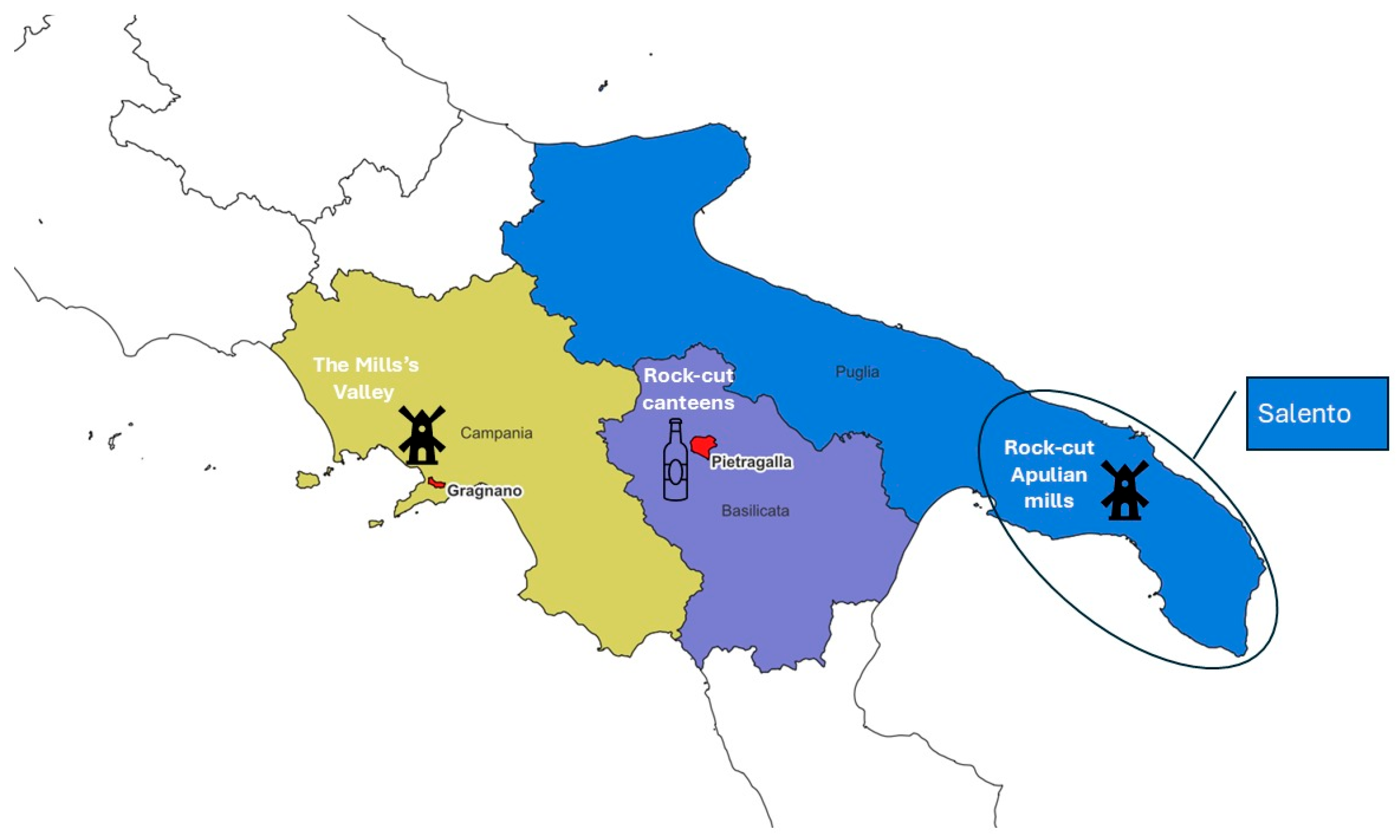
The first case study is the Pietragalla wine district in Basilicata Region, the second is the Apulian rock-cut olive oil mills system and the third is Mills’s Valley in Campania Region (Figure 5) [29].

3.1.1. Pietragalla and Its Wine District

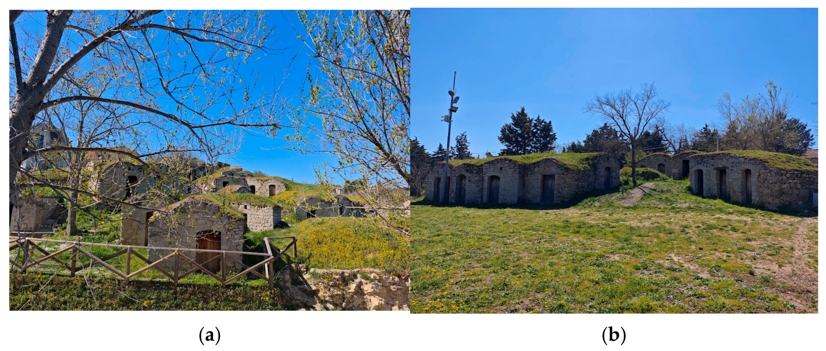
Pietragalla is a small village in the Basilicata Region (Italy). It is located at an altitude of 834 m above sea level (a.s.l.) and its rural economy has always been characterized by wine production. The wine district of Palmenti is a complex of about 200 rock-cut wine canteens located just in between the historical vineyards and the village; its existence is documented as early as 1705 [29,30,31]. The canteens were built by adopting the so-called negative building culture, “a building technique based on excavation and the subsequent removal of surplus from the underground to give shape to the final buildings, rather than on the adoption of building materials by addition to give shape to the final structures [32].” They have been excavated into natural sandstone rocks that emerge in the Tofi district, a place selected to combine the optimization of two different issues. First, it allowed for the maximization of the natural geological morphology of the area; secondly, the location minimized the distance between the vineyards and the village, where subsequent phases of the wine production were carried out. The complex consists of both single and multiple excavated canteens (Figure 6a,b) and reflects the capacity of local wine producers in modifying and adapting the natural landscape into functional spaces: bioclimatic rooms were set up to host the first phases of the production, but also for safety reasons.
The result is a fairy-tale landscape almost invisible from the outside and covered by vegetation that follows the rhythm of the seasons: green during spring, yellow in summer, brown in autumn, often covered by snow in winter. This aspect is a symbol of the strong relationship between the site and factors connected to the local natural environment: geological conformation, altitude, latitude and climatic conditions.
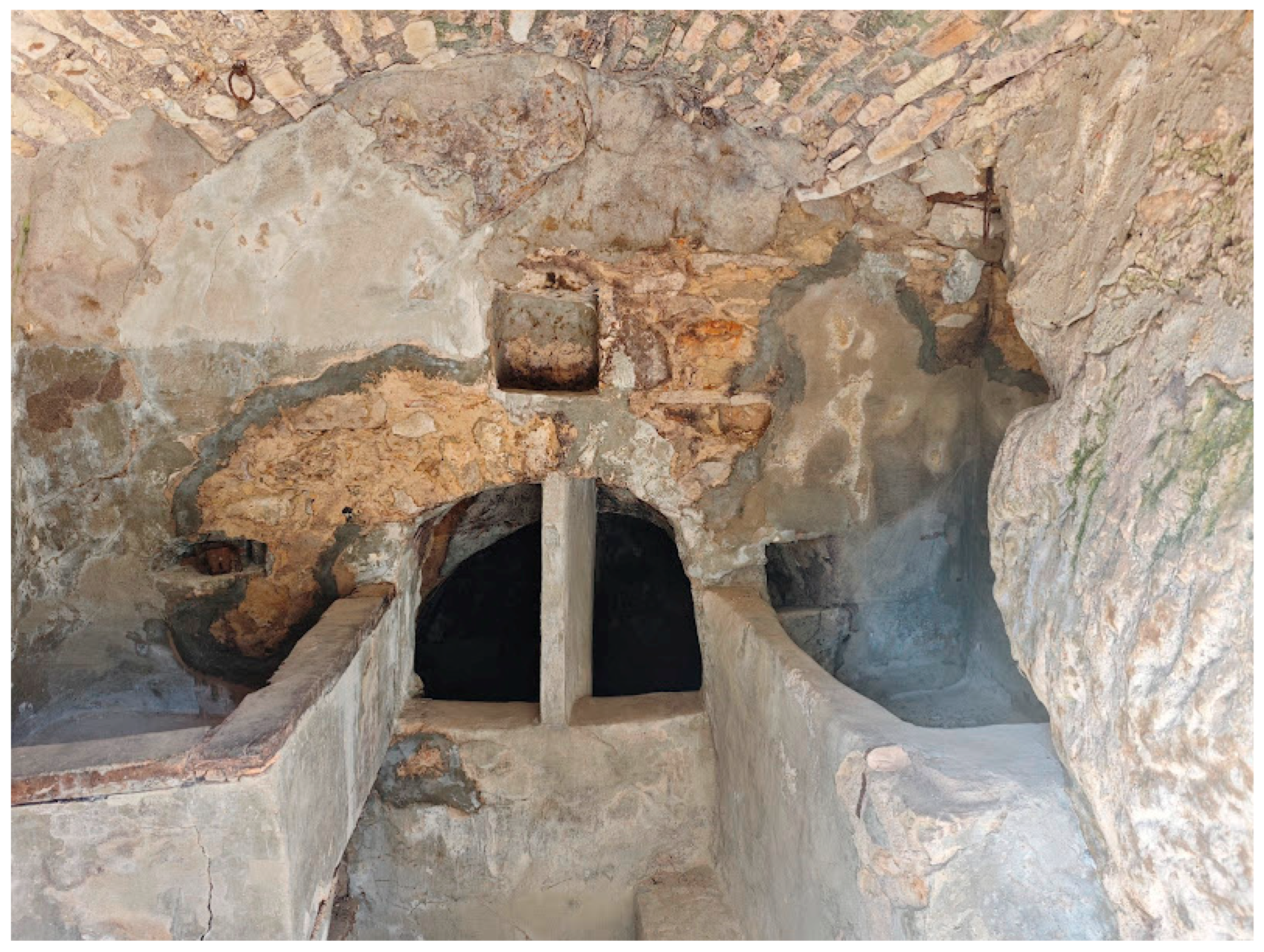
Rock-cut architecture was used in the organization of internal spaces as well. The organization of the internal spaces was sometimes intended only for a single wine producer, sometimes it was a collective space adopted by two (Figure 7) or three producers. Canteens were equipped with basins, decantation tanks, niches for the lamps, spaces for the tools, connection channels and an iron ring fixed to the ceiling of the pressing tank to be adopted as a grip; access to the wooden barrels was provided by vent openings [28].
The complex of excavated cellars represents the element that combines the tangible and intangible values of the cultural landscape. In fact, on the one hand, the complex of cellars is unique in the world in terms of identity, proximity to the village and architectural style: it reflects the profitable use of local geomorphology by adopting unique architectural skills for the solution of climatic and logistic features. On the other hand, the proximity between the vineyards and the village, leading to, for example, the use of interiors of rock-cut canteens for production, have strongly characterized the organization of work and the sharing of production spaces, all elements that have contributed to defining some unique intangible values for local communities.
However, this connection was interrupted in the seventies because the altitude at which vines were cultivated rose as an effect of the increase in annual temperature ranges in the Basilicata Region, and the logistic value of those rock-cut canteens vanished. In fact, data regarding the distribution of vineyards demonstrated that the increase in the annual temperature ranges occurring in the area in the last century caused the relocation of vineyards to a higher altitude [33,34,35,36,37]. This is a very common phenomenon in the Basilicata Region and caused the progressive increase in the vine cultivation altitude, which was gradually replaced by other crops compatible with the new temperatures, especially olive trees [38]. This aspect was confirmed during on-site inspections by the authors carried out in April 2025: no evidence of vineyards at the site’s altitude was found.
The phenomenon of increasing altitude in vine cultivation because of climate change is widespread [39] and has affected all Italian vineyard varieties. However, it has not always been possible to relocate the vineyards, and other approaches have been taken to manage the problem. In the case of Chianti wine, whose production is protected by very strict regulations [40] that set the maximum production altitude at 700 m a.s.l. in a defined area, whose maximum altitude is that of Mount San Michele (893 m a.s.l.), for example, the problem has been addressed in a different way. In this case, in order not to lose the designation and the correlation with the Chianti cultural landscape—also included in the UNESCO tentative list [41]—producers have adopted various strategies aimed at improving soil water retention and the use of agronomic techniques [42]. These include improving the water retention capacity of the soil, selecting the most resistant species among those permitted in the regulations, adapting pruning and shading systems, using drip irrigation and constant monitoring.
Since the vineyards in Pietragalla have been relocated and the connected cellars decommissioned, tools developed for the adoption of the concept of climate indicators for food-related architecture were adopted.
With reference to the adoption of the chart in Figure 1, the rock-cut canteens of Pietragalla can be considered as the result of the management of temperature, a variable climatic factor. This applies both to the external temperature, which influences the altitude of the crops, and to the internal temperature.
In Figure 8, the chart from Figure 3 was adopted for the analysis of the Pietragalla case study. It emerges that the potential of geological conformations, located at the same altitude of vineyards, was maximized by excavating rock-cut canteens in a very convenient location near the village. When the vineyards were relocated, as an effect of climatic changes, rock-cut canteens were abandoned. It is true that in the seventies, mechanical pressing was introduced, and that new technologies would not be compatible with the historical canteens but, as it emerged from interviews carried out during inspections, when mechanization was introduced in southern Italian minor vineries, Pietragalla rock-cut canteens had already been abandoned.
Based on the tests carried out, it can be said that the Pietragalla cellars are compatible with the concept of climate indicators. But what is the potential of the inclusion of this case study in the list of climatic indicators? Firstly, it should be noted that the Pietragalla site has already been the subject of various development projects by the municipality [43].
Today, the Pietragalla wine district has been transformed into an urban park included in the Italian Foundation for Environment (FAI) list, n. 1217 [44]. Rock-cut architectures are also the focus points of some marketing strategies adopted by local wine producers, and the wine district hosts several cultural events and wedding ceremonies. With reference to the connection with climatic issues, they have already been addressed within the current enhancement processes after their restoration, but they refer to the indoor thermoregulation guaranteed by rock-cut architecture (Figure 9c), while the role of the site as a climatic indicator has not been exploited yet.
In such a promising scenario, the adoption of the concept of climatic indicators could emphasise the significance of the site and its interpretation both as a cultural asset and within rural regeneration plans. Focus points of future actions, which include the adoption of the concept of climate indicators, can be summarized as follows:
  • Relationship between rural historical architecture, cultural landscape and its changes as an effect of climatic changes: The adoption of outputs of environmental history research in the enhancement of rural cultural assets.
  • History of resilience in agriculture: Valuable examples from Italian traditional cropping can be connected to the storytelling of this cultural asset.
  • Enhancement of intangible values: traditional rituals, festivals, lyrics and costumes connected to the history of rock-cut canteens.
  • Elements of social issues: sharing workspaces and tools in historical rural villages.

3.1.2. Olive Oil Architecture: Rock-Cut Apulian Mills

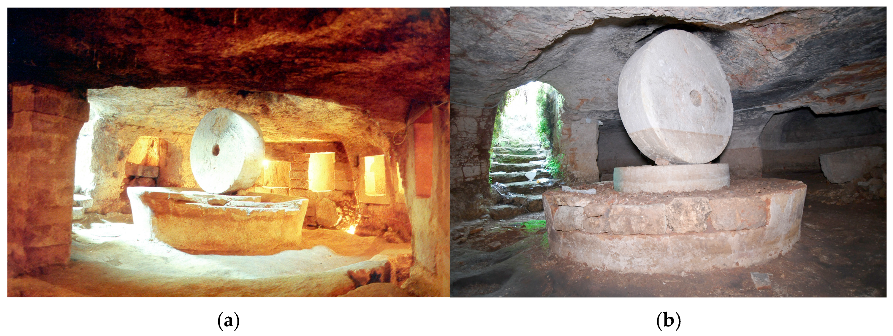
Olive oil production is the most widespread and typical Apulian production connected to the Mediterranean diet [45,46,47,48]. More than 150 rock-cut olive oil mills have been excavated throughout history in southern Apulia—in the Salento district—from the 15th century onwards (Figure 10a,b) [49]. Rock-cut olive oil mills, usually annexed to local farms, were built beside olive groves. The decision to build underground architecture, by adopting the negative building culture [32], met the following priorities: economy and speed of construction, adoption of local skills, thermal insulation and easy heating. Internal climatic control was a focus point: only hot temperatures—between 18 and 20 °C—could have made the olive pressing and fluidification of the oil possible during Apulian winters [49].
Rock-cut olive oil mills were the perfect solution for all the above-mentioned issues. First, as a result of previous research, as the local subsoil was mostly composed of calcarenite [50,51], the negative building technique [32] was not only possible but also the most convenient technical solution, particularly in a rural area where this technique was widespread for other uses as well [52]. Thermal insulation performances were also implemented by the adoption of the so-called “blood power” [53,54]. In fact, for the activation of the mechanism, mules were involved: they were introduced into the cavities at the beginning of the milling season and lived there their entire lives, producing the increase in internal temperatures [53,54].
These rock-cut structures were shaped to solve specific priorities: housing of machinery, storage of olives, transportation of oil and production waste, and accommodation of donkeys. Some common elements can be found, such as the presence of lathes with stone millstones, holes for pouring loads at the top of the ceiling, stairs or side access points and stables.
But while much has been written about these architectures, especially with reference to their connection with the local geology [50,51] and to their innovative contribution to proto-industrial technological advancement [53,54], the relationship with local climate at the time of their building has not yet been investigated, even though this was a determining factor for their construction.
With reference to this issue, it must be said that, although no historical climate series based on scientific evidence are available [55], the literature regarding climate change in Apulia—based on the study of heterogeneous sources—has made it possible to place the so-called small-scale Ice Age phase [56] precisely in the period when the construction of rock-cut olive oil mills took place. In fact, it was reported that this climatic phase took place in the period between 1590 and 1850 and led to a sharp drop in the climate, after which, the decommissioning of rock-cut mills started.
Based on this evidence, the concept of cultural assets as a solution for the management of climatic issues introduced in Figure 1 can be adopted: rock-cut olive oil mills were built to manage those adverse climatic temperatures that occurred during the Apulian small-scale Ice Age. However, not only their birth, but also their final abandonment coincides with the subsequent climatic phase, a progressive warming which took place in the period between 1870 and the seventies [56].
In addition, it should be noted that the olive tree itself is considered one of the best bio-indicators of climate change in the Mediterranean basin. The effects of climate change, in fact, as emerges from a recent study conducted by the Italian Council for Agricultural Research and Analysis of Agricultural Economics (CREA), have been measured in terms of growth patterns, pest proliferation and production. But while in the past, rising temperatures simply led to the abandonment of underground oil mills, today’s climate change adaptation and mitigation strategy is based on the following areas of intervention: water conservation, the use of carbon (CO2) supplements, and the selection of olive tree varieties compatible with the new climatic conditions [57].
With reference to the implications of new technologies, the introduction of electricity as a driving force was reported in the period between the 19th and 20th centuries [53] and cannot be related to the decommissioning of rock-cut olive oil mills.
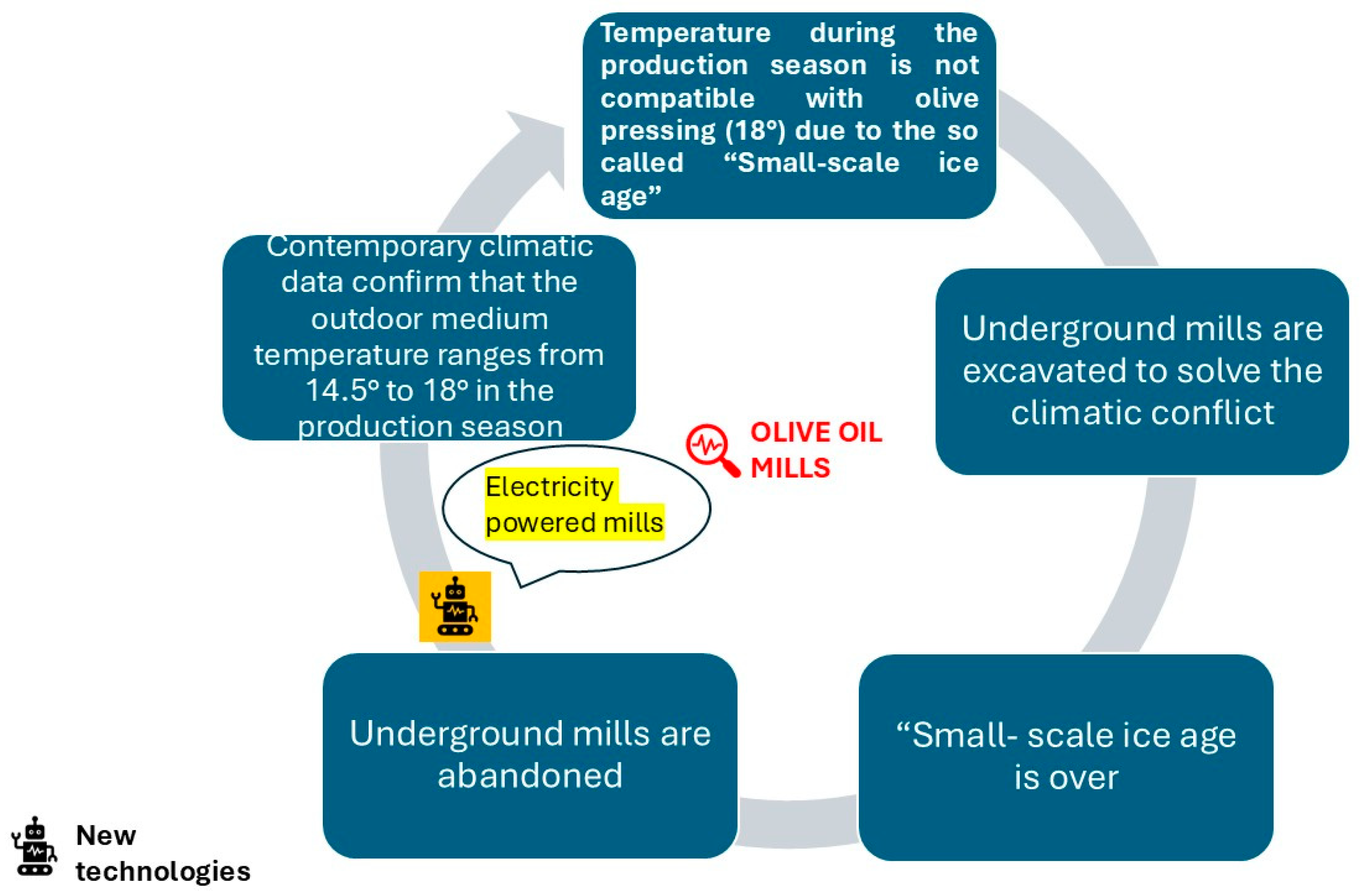
Based on the above, the methodological chart in Figure 3 can be applied to these structures (Figure 11). Analysis of the chart shows that the starting point in the history of these structures is the climatic emergency of the so-called Little Ice Age. During this phase, underground mills were introduced to make production easier, but they were abandoned as soon as the climate allowed for fluidification, from 1870 onwards, even in structures built on the surface. Subsequently, those structures were equipped with electric mills.
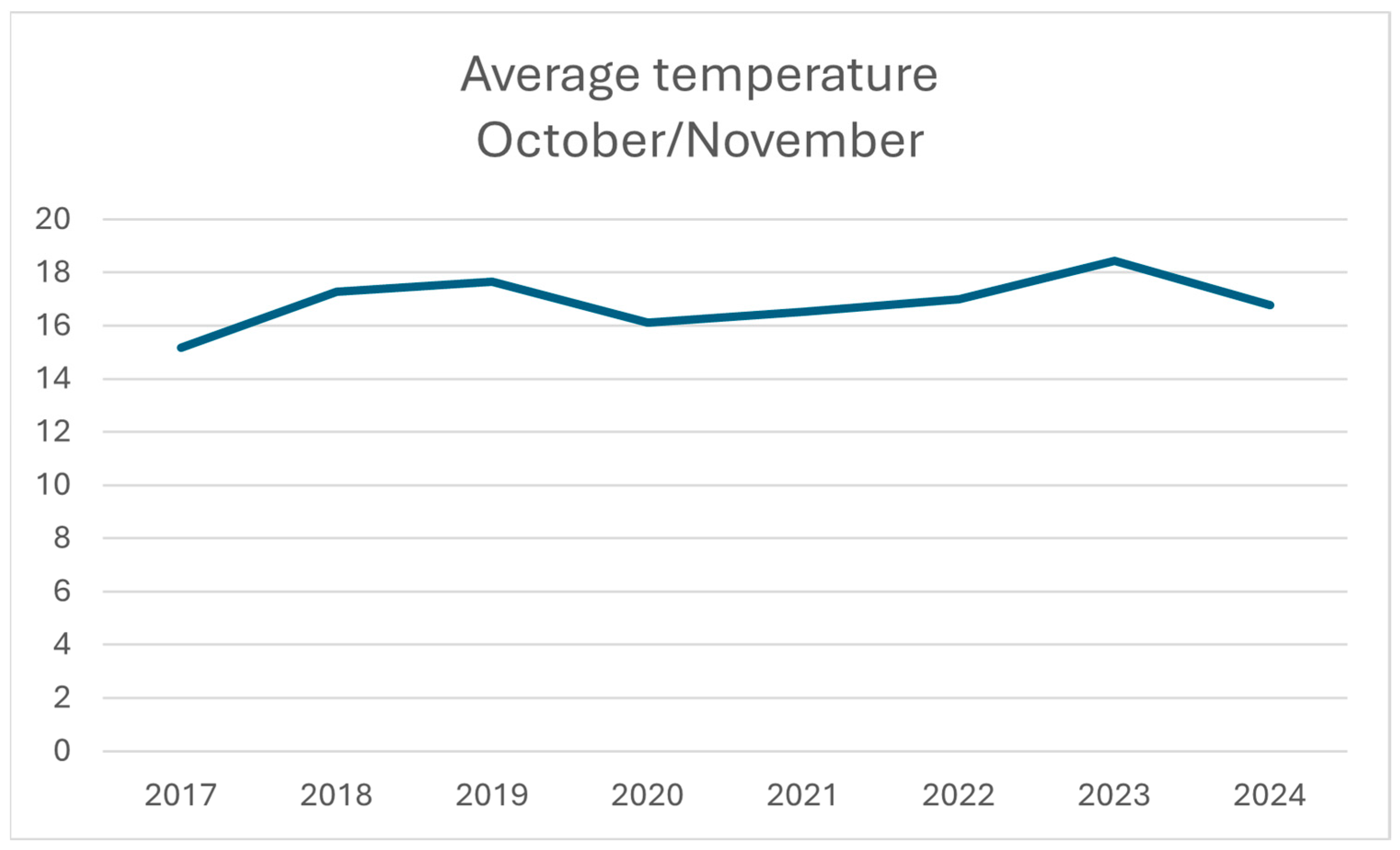
To complete the application of the climate indicators concept, Figure 12 shows data on temperature trends in recent years during the months October and November when olive pressing takes place. As shown in Figure 12, outdoor data today ranges between 15 and 18.5 °C, which is perfectly compatible with indoor pressing.
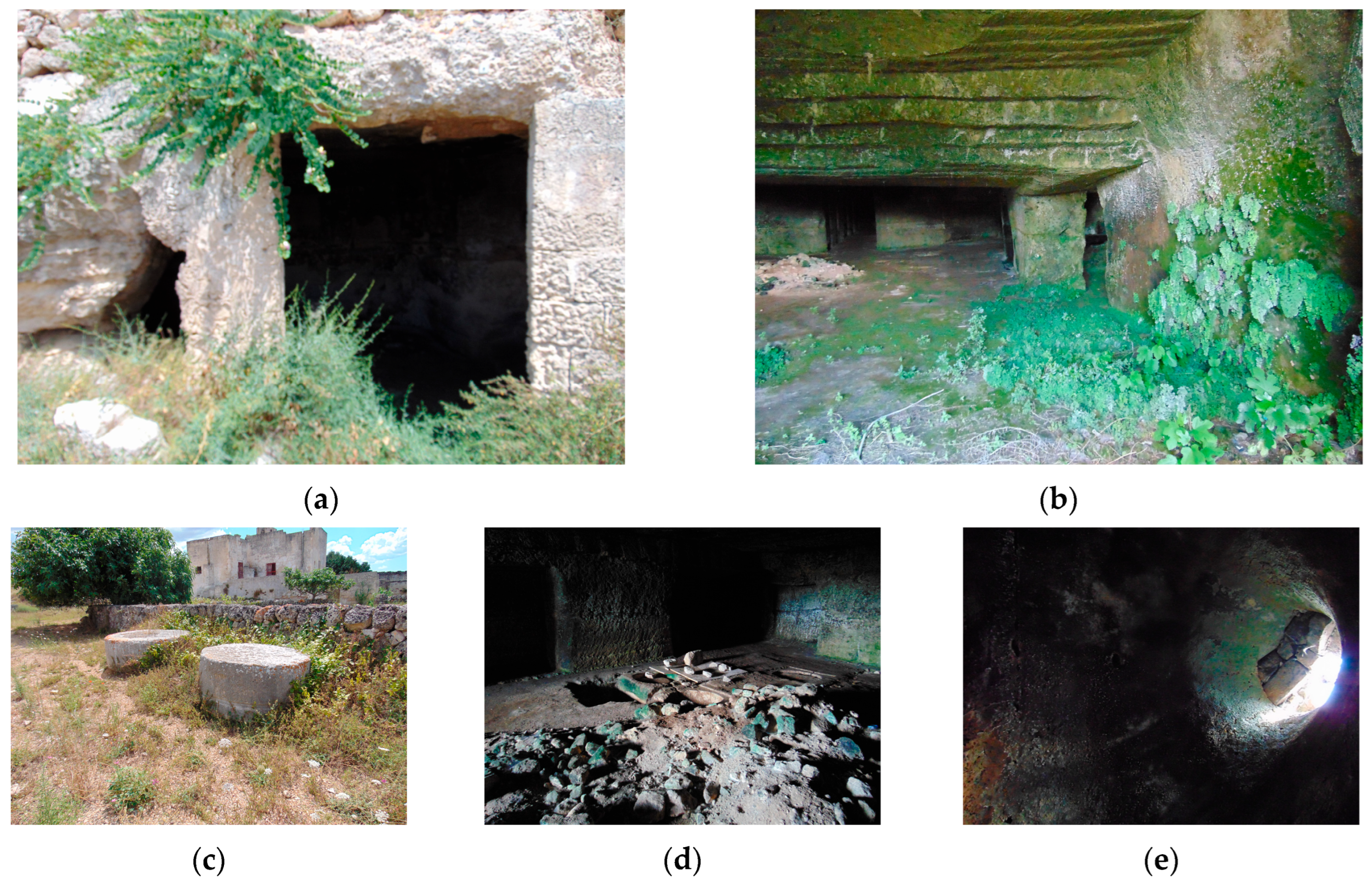
Today, based on their tangible and intangible values, these rock-cut architectures are considered as symbols of local identity and, even if most of them are in a state of abandonment (Figure 13), some of them were at the core of several enhancement projects.
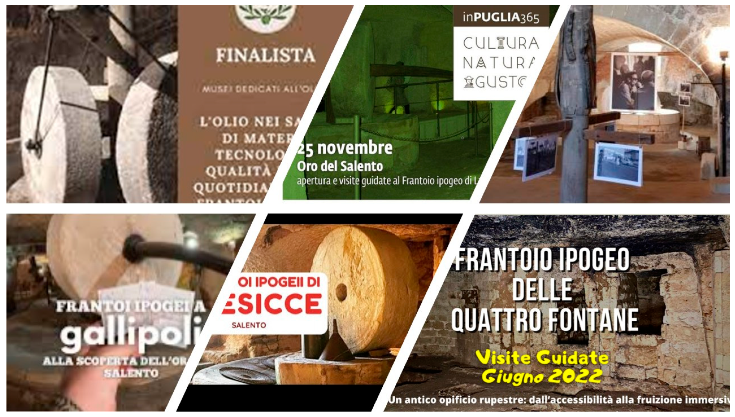
Regeneration processes are widespread as well. Sometimes, reconstructions have been created that reproduce the original use of historical rock-cut olive oil mills, and they have been transformed into rural museums. Sometimes, rock-cut olive oil mills serve as attractions for historical farms used in the tourist hospitality sector, while others are connected to current olive oil production (Figure 14). However, since shared protocols for sustainable reuse have not been developed yet and rock-cut olive oil mills are very often annexed to private properties, current owners do not have tools for their regeneration and museal setting. In all those contexts, even if both tangible and intangible values—such as excavation and pressing techniques, rural rituals, traditional foods, lyrics etc.—have been taken into consideration, this has not been the result of a systemic approach.
This situation impacts the difficulty of promoting them as parts of a unique disseminated cultural asset and their inclusion in networks with a national impact: only the Spongano rock-cut olive oil mill is inscribed in the FAI list [59]. Maybe the introduction of the concept of climate change indictors can implement the interpretation of rock-cut olive oil mills in the future and contribute—together with the classification of their tangible and intangible values and the development of protocols for their regeneration—to the creation of a dedicated network. Focus points of future actions in this direction can be summarized as follows:
  • Introduction to the small-scale Ice Age (1590–1850): effects on crops and on production;
  • The transition from animal power to mechanical power in the operation of rural machineries;
  • Tangible values of rural rock-cut architecture;
  • Intangible values associated with the use of rock-cut mills, the role of women, children and animals and related rural rituals.

3.1.3. The Mills’s Valley in Gragnano

Daily consumption of durum wheat, in the form of typical bread and pasta delicacies, is one of the pillars of the Italian Mediterranean diet [60,61]. Their production is connected to several food architectures: mills for the transformation of wheat into flour, warehouses for stocking, bakeries and pasta factories. The location of each of these structures was influenced by several factors throughout history, not always matching one to the other. The creation of a historical pasta food district is the result of the optimization of all of them: proximity to crops, proximity to energy sources to power the mills, availability of water for processing, and proximity to outlet markets. All those factors were connected to local natural environmental features, some of them were fixed, some variable. However, it was very common for pasta districts to be in the areas where mills were built.
Historical mills can be divided into two main groups: windmills and water mills [62]. While windmills have always been common in northern Europe and the Mediterranean islands, in southern Italy the use of water mills has been more prevalent throughout history. Since proximity to waterways was a determining factor in the location of pasta factories, it was very common for the same water source to be adopted as a power source and as an ingredient in the production process as well.
This is the case of the historical Gragnano pasta district (Figure 15); the focus point of its development was the Vernotico river, in the territory of the Lattari mountains in the Campania Region. The river was perfect for its purpose: its flow and slope were perfect for the construction of water mills, and its waters were of good quality for use in production. The construction of water mills started in the 13th century, and the relationship between mills and the valley became soon so distinctive that it led to the adoption of the toponym Mills’s Valley [63,64] (Figure 16).
The adopted architecture was a combination of two building techniques, both typical of the area: the walls are made of limestone and grey tuff with roughly hewn blocks, while the towers are built of tuff masonry [65]. The mechanism adopted in the transformation of Vernotico hydraulic forces into energy was the result of an empiric approach based on the natural environment: the so called proto-industrial horizontal wheel mechanism [62]. Recent studies demonstrated that their construction was not the result of a series of entrepreneurial initiatives, but rather of a unified plan aimed at transforming the entire area into a manufacturing district. The focus of this project was the transformation of natural potential into widespread benefits for the community [66].
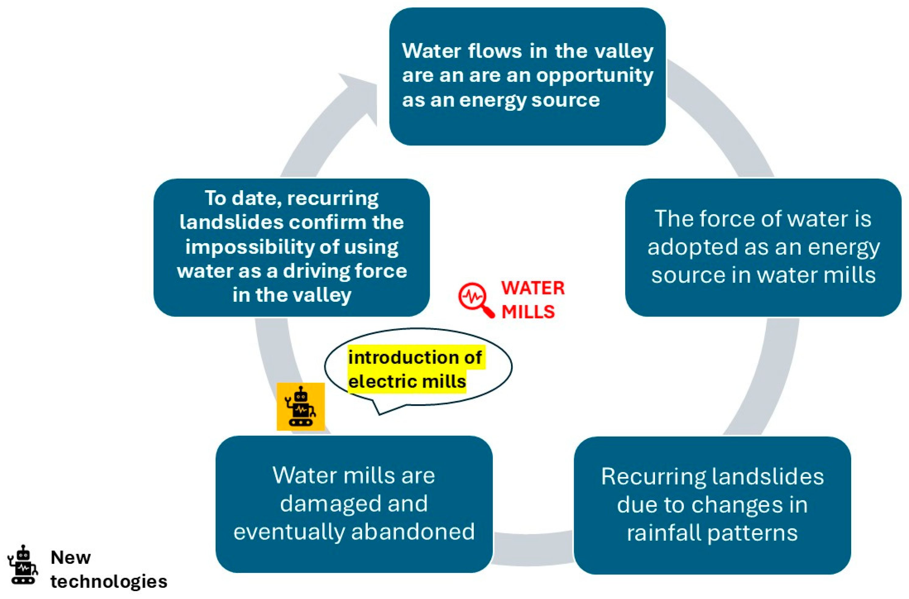
This approach fits with the flow chart introduced in Figure 1. In that context, the Gragnano mills were linked to two environmental factors: the slope can be classified as a fixed factor, and water pressure as a flexible factor. It is precisely the effects of changes in the river’s flow and connected landslides that led to the abandonment of the mills.
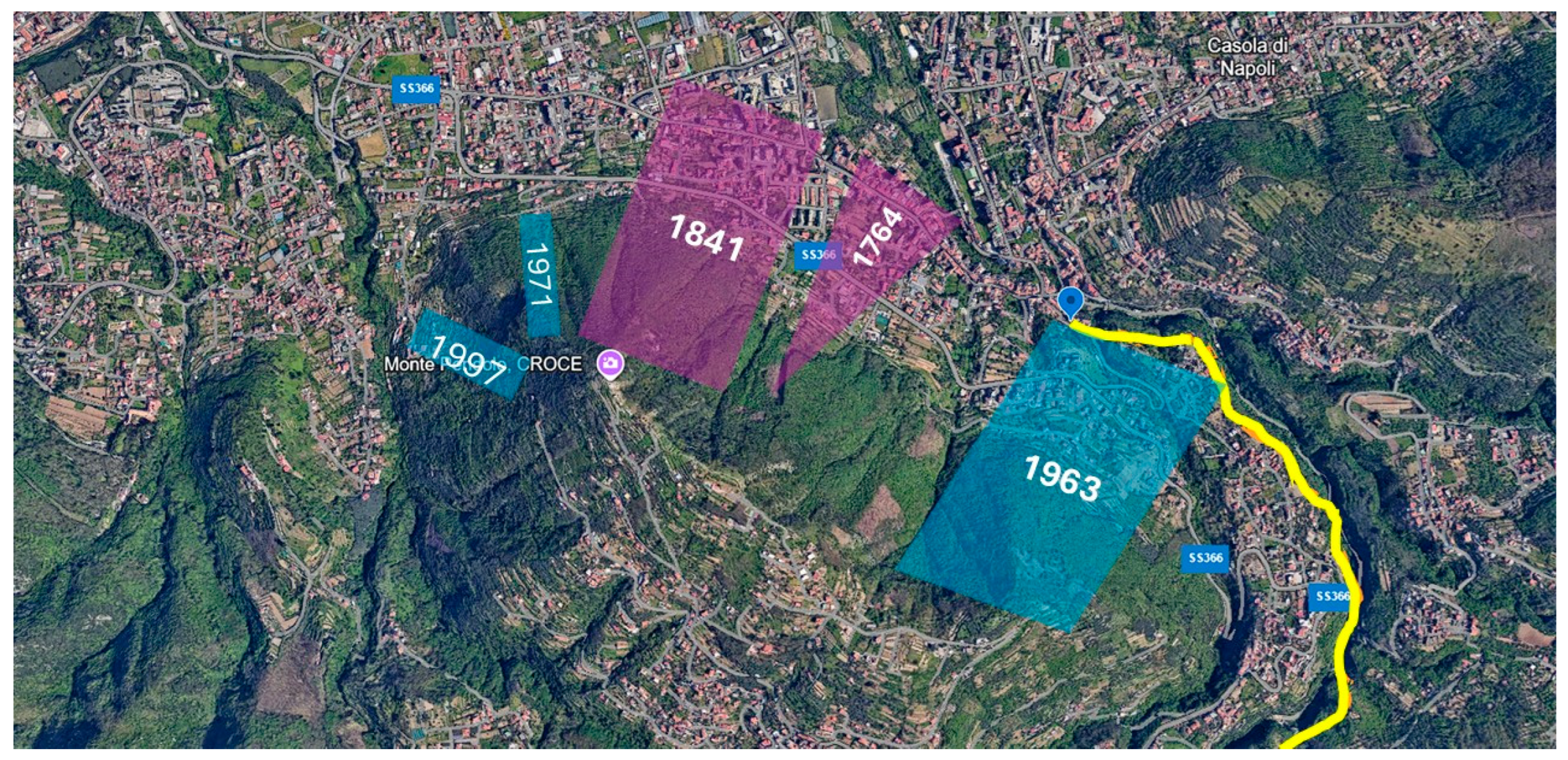
Recurrent catastrophic floodings are documented in the 18th century (Figure 17): in 1764, an exceptional flood with more than 40 victims, and in 1841 another event with over 103 victims, three of them inside the mills [67]. Recent studies confirm that the Mills’s Valley “series of rainfall anomalies has been evaluated for seasonal and annual timescales” [67]. Data collected at the Gragnano station, which analyses historical rainfall (1918–2015), has made it possible to include the area among the few (27% of the total sample) for which there has been a steady increase in rainfall, especially of an exceptional nature [68]. Based on this evidence, the Mills’s Valley is “one of the most reactive to climate change” [69]. It is in this context of changes in rainy intensity that the recurring landslides in the valley can be understood; after centuries of stability, exceptional rains have set in motion deposits dating back to the eruption of Vesuvius in 79 AD [70].
This situation has been intertwined with the life of the mills, which, as an effect of recurrent floods between the end of the 18th and the beginning of the 19th century, were gradually abandoned. As an effect of this still existent risk of flooding—new events were reported in 1963, 1971 and 1997—(Figure 17), the valley is still today the focus point of many environmental monitoring projects [71,72,73,74,75,76].
Certainly, new mills adopted electricity as a power force, but there is no doubt that the abandonment of the mills is due to their partial destruction and the danger of further landslides.
Based on this evidence, the concept of climatic indicators introduced at a theoretical level in Figure 3 can also be adopted for the Mills’s Valley. Figure 18 summarizes the passage from the potential opportunity in terms of energy supplies offered by water flows of Vernotico river to the construction of the mills. The construction of the mills was the main reason why the pasta industrial district developed, and it ended up characterizing the economic vocation of the area. Unfortunately, changes in rainfall patterns and intensity began to cause damage to the mills, which were subsequently abandoned. However, the Gragnano pasta district, due to its identity characteristics, was not relocated, and new electric mills have allowed the activity to continue. In conclusion, contemporary data confirms the hydrogeological risk of the area.
Today, the Mills’s Valley is a successful productive district in the pasta sector [77,78]: its products are inscribed on the Protected Areas of Production list (IGP) [79]. Some marketing and branding strategies adopt the historical landscape of the valley and the cultural value of water mills as well. Those aspects also stimulated multidisciplinary research and several enhancement processes in the fields of nature and cultural tourism were carried out [80,81,82]. Water mills are the focus points of all those projects, above all, when the Historic Urban Landscape (HUL) approach proposed by UNESCO is adopted [83,84,85]. Today the Mills’s Valley is a FAI site [86], is listed in the paths of the Italian Alpine Club (CAI) [87] and has been the subject of various regeneration projects [88].
However, in all the regeneration projects listed above, the Mills’s Valley has been considered as a whole, without considering the identity and the history of each mill, in connection with the local architecture, the territory and its natural and artificial transformations. In fact, as summarized in Table 1, each one of the thirteen mills inspected during the on-site visit—the only ones we could detect—could provide additional elements for the interpretation of the serial site: connection with defensive and residential architecture, effects of the riverbed restoration work to optimize its potential as an energy source, historical reuses, chronology of the district’s development, different technical solutions and architecture, etc. [64].
In addition to all these potential focus points for the interpretation of single mills, the introduction of the concept of climate indicators makes it possible to identify new potential shared focus points as well. They are summarized as follows:
  • Climate change and territorial vulnerability;
  • Risk monitoring and control;
  • Inclusion in the environmental history network of climate change-related disasters: floods, droughts, landslides, etc.;
  • Resilience to climate change: relocation and transformation of productive districts.

3.2. Discussion

In Table 2, the main characteristics of the selected case studies are summarized, picking up data and results from Figure 1, Figure 3, Figure 8, Figure 11 and Figure 18. In the first column, dedicated to the classification of the type of food-related architecture, the same symbol adopted in the pyramid of Figure 4 is associated with the selected case studies. In the second column, the name of the case study is inserted, while in the third, the food production connected to the case study is explained. In the fourth, the connected climatic issues, as classified in Figure 1, are reported. In the fifth, how their potential was adopted in the productive processes is listed. In the sixth, the Italian region where the case studies are located is detailed, and in the seventh, periods regarding their introduction and their decommissioning are listed. In the eighth, climatic changes that impacted the architectures during their lifespans are listed as examined in the case studies Section 3.1.1, Section 3.1.2 and Section 3.1.3. In the ninth, the level of current enhancement processes—public or private—is mentioned, based on the results from the analysis of projects dedicated to the case studies’ regeneration.
Table 2 summarizes the results of research, but it is also suitable for adoption at a theoretical level for the comparative analysis of homogeneous case studies in the class of climatic indicators.
The analysis carried out so far has highlighted the potential of adopting the concept of climate indicators in regeneration processes. The potential focus points of these actions can be summarized as follows:
  • Climate indicators can be a gateway to climate change issues and enrich the storytelling of the corresponding cultural assets;
  • Climate indicators can enable the creation of dedicated networks;
  • Climate integrators can provide access to additional tangible and intangible values.
Based on these results, the thesis of the research is demonstrated.

4. Conclusions

The introduction of the theoretical concept of climatic indicators dedicated to selected food-related architectures and the elaboration of charts in Figure 1 and Figure 3 provide a methodological approach for the study of the complex relationship between climatic factors, their changes throughout history and cultural assets.
The tools provided have several potential applications: the theoretical concept of climatic indicators for cultural assets can be an opportunity for climatic studies, for cultural heritage sciences and for rural development plans.
With reference to the first potential application, climatic indicators can be adopted as indirect historical sources for the study of climatic changes according to the suggestions provided by some environmental history studies. In fact, they can support the historical reconstruction of historical climatic series with evidence from proto-industrial and industrial structures and machineries.
With reference to the second application, the concept of climatic indicators can provide innovative elements for the interpretation of some minor cultural assets. Even if case studies were selected within the group of food-related architectures, the theoretical concept has a broader potential. It can be adopted to study several rural minor cultural assets such as transport infrastructures, proto-industrial and industrial structures, etc.
With reference to the third application, the concept of climatic indicators can be considered as an advancement compared with previous studies which considered the potential cultural value of food-related architecture in branding and marketing strategies for the enhancement of traditional local products [89]. However, the inclusion of elements related to climate change in rural development finds its place in the broader context of the European Union’s Strategic Plan for Agricultural Policy for the period 2023–2027, which already includes the objective of increasing the resilience and adaptation of the primary sector to climate change. This objective is supported by the following actions: (i) promoting the diversification of the agricultural ecosystem; (ii) supporting the adoption of practices that promote water saving or improve the efficiency of water use; and (iii) promoting the conservation or restoration of agricultural ecosystems and habitats threatened by climate change, including actions to prevent and restore forest damage resulting from natural disasters [90]. Furthermore, to promote a smart and resilient agricultural sector, direct payments continue to be an essential part of ensuring adequate income support for farmers. Similarly, investments in farm restructuring, modernization, innovation, diversification and the use of new practices and technologies are necessary to improve farmers’ market premiums [91]. In this context, the adoption of the concept of climatic indicators can provide examples of historical approaches to resilience and the adaptation of food production to climate change.
In conclusion, this research has introduced a theoretical concept that requires further testing before it can be applied globally. For this reason, a project is currently being drafted to enable its verification on a larger scale and, above all, to assess the impact of various factors on the abandonment of this type of architecture. However, the introduction of the concept of climatic indicators aims to be an example of the potential of the humanities’ contribution to natural sciences in general, also promoting the adoption of indirect sources when data are unavailable or unreliable.

Author Contributions

Conceptualization, R.V.; methodology, R.V.; validation, R.V. and R.C.; formal analysis, R.V. and R.C.; investigation, R.V. and R.C.; data curation, R.V. and R.C.; writing—original draft preparation, R.V.; writing—review and editing, R.V. and R.C.; supervision, R.V. All authors have read and agreed to the published version of the manuscript.

Funding

This research received no external funding.

Data Availability Statement

The original contributions presented in this study are included in the article. Further inquiries can be directed to the corresponding author.

Acknowledgments

The authors thank Aniello Barone, Paolo Pironti and Giovanni Ruggiero for support in editing the paper and Gabriella Visco for the English revision. The authors have reviewed and edited the output and take full responsibility for the content of this publication.

Conflicts of Interest

The authors declare no conflicts of interest.

References

  1. Mediterranea Diet. UNESCO Intangible Cultural Heritage List. Available online: https://ich.unesco.org/en/RL/mediterranean-diet-00884 (accessed on 8 July 2025).
  2. Roigé, X.; Frigolé Reixach, J. Constructing Cultural and Natural Heritage: Parks, Museums and Rural Heritage; Institut Català de Recerca en Patrimoni Cultural: New Delhi, India, 2010; pp. 1–233. [Google Scholar]
  3. Prideaux, B.R.; Kininmont, L.E. Tourism and heritage are not strangers: A study of opportunities for rural heritage museums to maximize tourism visitation. J. Travel Res. 1999, 37, 299–303. [Google Scholar] [CrossRef]
  4. Pawlikowska-Piechotka, A.; Lukasik, N.; Ostrowska-Tryzno, A.; Sawicka, K. The rural open air museums: Visitors, community and place. Eur. Countrys. 2015, 7, 195. [Google Scholar] [CrossRef]
  5. Carbone, A.; Henke, R. Recent trends in agri-food Made in Italy exports. Agric. Food Econ. 2023, 11, 32. [Google Scholar] [CrossRef]
  6. Lionello, P. (Ed.) The Climate of the Mediterranean Region: From the Past to the Future; Elsevier: Oxford, UK, 2012. [Google Scholar]
  7. Luino, F.; Barriendos, M.; Gizzi, F.T.; Glaser, R.; Gruetzner, C.; Palmieri, W.; Porfido, S.; Sangster, H.; Turconi, L. Historical data for natural hazard risk Mitigation and land use planning. Land 2023, 12, 1777. [Google Scholar] [CrossRef]
  8. Sharma, P.D. Ecology and Environment; Rastogi Publications: Meerut, India, 2009; p. 17. [Google Scholar]
  9. Falco, G. Snow and Ice in Antiquity. Supply, Preserving, Trade, Consumption. In Archaeology and Economy in the Ancient World, Proceedings of the 19th International Classical Archaeology, Cologne-Bonn, Germany, 22–26 May 2018; Heidelberg University: Heidelberg, Germany, 2022. [Google Scholar]
  10. Prakash, O.; Kumar, A. Historical Review and Recent Trends in Solar Drying Systems. Int. J. Green Energy 2013, 10, 690–738. [Google Scholar] [CrossRef]
  11. Prasad, G.; Sarkar, S.; Sethi, L.N. Solar Drying Technology for Agricultural Products: A Review. Agric. Rev. 2024, 45, 579–589. [Google Scholar] [CrossRef]
  12. Inderhaug, T. Stockfish Production, Cultural and Culinary Values. Food Ethics 2020, 5, 6. [Google Scholar] [CrossRef]
  13. Maltin, E.; Jonsson, L. Cod Heads, Stockfish, and Dried Spurdog: Unexpected Commodities in Nya Lödöse (1473–1624), Sweden. Int. J. Hist. Archaeol. 2018, 22, 343–363. [Google Scholar] [CrossRef]
  14. Enzi, S.; Bertolin, C.; Diodato, N. Snowfall time-series reconstruction in Italy over the last 300 years. Holocene 2014, 24, 346–356. [Google Scholar] [CrossRef]
  15. Zarzyczny, K.M.; Rius, M.; Williams, S.T.; Fenberg, P.B. The ecological and evolutionary consequences of tropicalisation. Trends Ecol. Evol. 2024, 39, 267–279. [Google Scholar] [CrossRef]
  16. Covey, R.A. Kinship and the Inca imperial core: Multiscalar archaeological patterns in the Sacred Valley (Cuzco, Peru). J. Anthropol. Archaeol. 2015, 40, 183–195. [Google Scholar] [CrossRef]
  17. Issar, A.S.; Zohar, M. The impact of climate changes on the evolution of water supply works in Jerusalem. In Evolution of Water Supply Through the Millennia; Angelakis, A.N., Mays, L.W., Koutsoyiannis, D., Mamassis, N., Eds.; IWA publishing: London, UK, 2019. [Google Scholar]
  18. Naureen, Z.; Dhuli, K.; Donato, K.; Aquilanti, B.; Velluti, V.; Matera, G.; Iaconelli, A.; Bertelli, M. Foods of the Mediterranean diet: Tomato, olives, chili pepper, wheat flour and wheat germ. J. Prev. Med. Hyg. 2022, 63 (Suppl. 3), E4. [Google Scholar]
  19. Saulle, R.; La Torre, G. The Mediterranean Diet, recognized by UNESCO as a cultural heritage of humanity. Ital. J. Public Health 2010, 7, 414–415. [Google Scholar] [CrossRef]
  20. Bonaccio, M.; Iacoviello, L.; Donati, M.B.; de Gaetano, G. The tenth anniversary as a UNESCO world cultural heritage: An unmissable opportunity to get back to the cultural roots of the Mediterranean diet. Eur. J. Clin. Nutr. 2022, 76, 179–183. [Google Scholar] [CrossRef]
  21. Willett, W.C.; Sacks, F.; Trichopoulou, A.; Drescher, G.; Ferro-Luzzi, A.; Helsing, E.; Trichopoulos, D. Mediterranean diet pyramid: A cultural model for healthy eating. Am. J. Clin. Nutr. 1995, 61, 1402S–1406S. [Google Scholar] [CrossRef]
  22. Bach-Faig, A.; Berry, E.M.; Lairon, D.; Reguant, J.; Trichopoulou, A.; Dernini, S.; Medina, F.X.; Battino, M.; Belahsen, R.; Miranda, G.; et al. Mediterranean diet pyramid today. Science and cultural updates. Public Health Nutr. 2011, 14, 2274–2284. [Google Scholar] [CrossRef] [PubMed]
  23. D’Alessandro, A.; De Pergola, G. Mediterranean diet pyramid: A proposal for Italian people. Nutrients 2014, 6, 4302–4316. [Google Scholar] [CrossRef]
  24. Carluccio, M.A.; Siculella, L.; Ancora, M.A.; Massaro, M.; Scoditti, E.; Storelli, C.; Visioli, F.; Distante, A.; De Caterina, R. Olive oil and red wine antioxidant polyphenols inhibit endothelial activation: Antiatherogenic properties of Mediterranean diet phytochemicals. Arterioscler. Thromb. Vasc. Biol. 2003, 23, 622–629. [Google Scholar] [CrossRef] [PubMed]
  25. Martínez-González, M.A. Should we remove wine from the Mediterranean diet? A narrative review. Am. J. Clin. Nutr. 2024, 119, 262–270. [Google Scholar] [CrossRef] [PubMed]
  26. Calabrò, F.; Cassalia, G.; Tramontana, C. The mediterranean diet as cultural landscape value: Proposing a model towards the inner areas development process. Procedia-Soc. Behav. Sci. 2016, 223, 568–575. [Google Scholar] [CrossRef]
  27. Catalogo Generale Beni Culturali. Available online: https://catalogo.beniculturali.it/ (accessed on 2 September 2025).
  28. Varriale, R.; Ciaravino, R. Food Architecture as Drivers for the Enhancement of Local Specialties and Sustainable Rural Regeneration. In World Heritage and Food to Feed; Gambardella, C., Ed.; Napoli-Capri (Italy), Gangemi Editore spa: Roma, Italy, 2025; pp. 75–85. [Google Scholar]
  29. Comune di Pietragalla. Available online: https://www.comune.pietragalla.pz.it/ (accessed on 25 July 2025).
  30. Parco Urbano dei Palmenti: Memoria e cultura del fare. Available online: https://patriadellabellezza.it/atlante-di-bellezza/parco-urbano-dei-palmenti-a-pietragalla-memoria-e-cultura-del-fare (accessed on 3 October 2025).
  31. Bixio, A.; Cardinale, T.; Damone, G. L’analisi per il recupero dell’architettura per sottrazione in Basilicata. Il caso di Pietragalla in provincia di Potenza. In Quale Sostenibilità Per Il Restauro? Marghera Venezia: Venice, Italy, 2014; pp. 315–325.
  32. Varriale, R. Underground Built Heritage. Encyclopedia 2025, 5, 92. [Google Scholar] [CrossRef]
  33. Cardell, M.F.; Amengual, A.; Romero, R. Future effects of climate change on the suitability of wine grape production across Europe. Reg. Environ. Change 2019, 19, 2299–2310. [Google Scholar] [CrossRef]
  34. van Leeuwen, C.; Sgubin, G.; Bois, B.; Ollat, N.; Swingedouw, D.; Zito, S.; Gambetta, G.A. Climate change impacts and adaptations of wine production. Nat. Rev. Earth Environ. 2024, 5, 258–275. [Google Scholar] [CrossRef]
  35. Jones, G.V. Climate, grapes, and wine: Structure and suitability in a changing climate. In XXVIII International Horticultural Congress on Science and Horticulture for People (IHC2010): International Symposium on the 931; ISHS: Leuven, Belgium, 2010. [Google Scholar]
  36. Irimia, L.M.; Patriche, C.V.; Quenol, H.; Sfîcă, L.; Foss, C. Shifts in climate suitability for wine production as a result of climate change in a temperate climate wine region of Romania. Theor. Appl. Climatol. 2018, 131, 1069–1081. [Google Scholar] [CrossRef]
  37. Irimia, L.M.; Patriche, C.V.; Roșca, B. Climate change impact on climate suitability for wine production in Romania. Theor. Appl. Climatol. 2018, 133, 1–14. [Google Scholar] [CrossRef]
  38. Raincaldo, P. In Basilicata le Vigne Salgono in Quota per Sopravvivere, La Repubblica. 7 March 2024. Available online: https://www.repubblica.it/green-and-blue/2024/03/07/news/in_basilicata_le_vigne_salgono_in_quota_per_sopravvivere-422256190/ (accessed on 25 March 2025).
  39. Candiago, S. An ecosystem service approach to the study of vineyard landscapes in the context of climate change: A review. Sustain. Sci. 2023, 18, 997–1013. [Google Scholar] [CrossRef] [PubMed]
  40. Disciplinare Chianti Classico. Available online: https://www.chianticlassico.com/wp-content/uploads/2020/11/disciplinare-Chianti-Classico.pdf (accessed on 1 September 2025).
  41. The System of the Ville-Fattoria in Chianti Classico. Available online: https://whc.unesco.org/en/tentativelists/6654/ (accessed on 31 August 2025).
  42. Zhu, X.; Moriondo, M.; Van Ierland, E.C.; Trombi, G.; Bindi, M. A model-based assessment of adaptation options for Chianti wine production in Tuscany (Italy) under climate change. Reg. Environ. Change 2016, 16, 85–96. [Google Scholar] [CrossRef]
  43. Comune di Pietragalla, Recupero e Valorizzazione del Parco Urbano dei Palmenti. Available online: https://patrimonioculturale.regione.basilicata.it/rbc/upload/file_1456395002154.pdf (accessed on 28 August 2025).
  44. FAI. I Luoghi del Cuore. Il Parco Urbano dei Palmenti. Available online: https://fondoambiente.it/luoghi/parco-urbano-dei-palmenti?ldc (accessed on 28 August 2025).
  45. Uylaşer, V.; Yildiz, G. The historical development and nutritional importance of olive and olive oil constituted an important part of the Mediterranean diet. Crit. Rev. Food Sci. Nutr. 2014, 54, 1092–1101. [Google Scholar] [CrossRef]
  46. Wahrburg, U.; Kratz, M.; Cullen, P. Mediterranean diet, olive oil and health. Eur. J. Lipid Sci. Technol. 2002, 104, 698–705. [Google Scholar] [CrossRef]
  47. Longobardi, F.; Ventrella, A.; Casiello, G.; Sacco, D.; Catucci, L.; Agostiano, A.; Kontominas, M.G. Instrumental and multivariate statistical analyses for the characterisation of the geographical origin of Apulian virgin olive oils. Food Chem. 2012, 133, 579–584. [Google Scholar] [CrossRef]
  48. Di Loreto, M.V.; Lago-Olveira, S.; Di Noia, N.; Vollero, L.; Pennazza, G.; Santonico, M.; González-García, S. A Comprehensive Environmental Analysis of Olive Oil Production in Apulia, Italy. Food Bioprod. Process. 2025, 151, 242–257. [Google Scholar] [CrossRef]
  49. Monte, A. Le macchine in uso nei processi storici di produzione dell’olio. Patrim. Ind. 2009, 4, 42–53. [Google Scholar]
  50. Margiotta, S.; Martellotta, M.; Parise, M. Inventory and analysis of underground oil mills in the territory of Lecce (Apulia, southern Italy). In Proceedings of the International Congress of Speleology in Artificial Caves, Dobrich, Bulgaria, 20–25 May 2019; Zhalov, A., Gyorev, V., Delchev, P., Eds.; pp. 33–38. [Google Scholar]
  51. Margiotta, S.; Martellotta, M.; Parise, M. Archeologia industriale e geologia: Proposta di recupero dei frantoi ipogei di Lecce. In Geologia dell’Ambiente; ITA: Rome, Italy, 2019; pp. 76–81. [Google Scholar]
  52. Varriale, R. Southern underground space: From the history to the future. In Proceedings of the International Conference of Speleology in Artificial Cavities, Central Anatolia, Turkey, 6–10 March 2017; Parise, M., Galeazzi, C., Bixio, R., Yamac, A., Eds.; Dijital Düşler: Istanbul, Hypogea, 2017; pp. 548–555. [Google Scholar]
  53. Monte, A. dell’olio. In Itinerari di Archeologia Industrial nel Salento; Edizioni del Grifo: Lecce, Italy, 2003. [Google Scholar]
  54. Monte, A. Recupero e conservazione dei trappeti ipogei del Salento. In Proceeding of the Congresso Nazionale ICIIC, Matera, Italy, 10–12 October 2019. [Google Scholar]
  55. Osservatorio Geofisico di Modena. Available online: https://www.ossgeo.unimore.it/temi-ambientali/la-serie-storica-di-temperatura/ (accessed on 10 July 2025).
  56. Pennetta, L. Caratteri ed evoluzione dei litorali pugliesi in relazione al clima del passato. Geol. Territ. 2007, 3–4, 131–144. [Google Scholar]
  57. Il Cambiamento Climatico e le Nuove Sfide Dell’ovicoltura. Available online: https://oleario.crea.gov.it/wp-content/uploads/2022/06/Il-cambiamento-climatico-e-le-nuove-sfide-per-l_olicoltura.pdf (accessed on 30 August 2025).
  58. Stazione RRQA Meteo Galatina (LE). Available online: https://dati.puglia.it/ckan/dataset/dati-meteo-rrqa-2024/resource/875561dd-c213-4a48-bccd-703f975fa31f?inner_span=True (accessed on 30 August 2025).
  59. FAI. Frantoio Ipogeo di Spongano. Available online: https://fondoambiente.it/luoghi/frantoio-ipogeo-di-spongano (accessed on 25 August 2025).
  60. Porceddu, E. Durum wheat quality in the Mediterranean countries. Durum Wheat Qual. Mediterr. Reg. 1995, 22, 11–21. [Google Scholar]
  61. Royo, C.; Soriano, J.M.; Alvaro, F. Wheat: A crop in the bottom of the Mediterranean diet pyramid. In Mediterranean Identities-Environment, Society, Culture; IntechOpen: London, UK, 2017. [Google Scholar]
  62. Hills, R.L. Power from Wind: A History of Windmill Technology; Cambridge University Press: Cambridge, UK, 1996. [Google Scholar]
  63. La Valle dei Mulini. Available online: https://www.valledeimulinigragnano.it/post/la-valle-dei-mulini (accessed on 25 July 2025).
  64. La Valle dei Mulini di Gragnano. Available online: https://www.valledeimulinigragnano.it/ (accessed on 25 July 2025).
  65. Ceniccola, G. Water architecture’ and cultural identity. The Valley of the mills in Gragnano. In La Baia di Napoli; Aveta, A., Marino, B.G., Amore, R., Eds.; Artstudiopaparo s.r.l.: Naples, Italy, 2017; pp. 214–218. [Google Scholar]
  66. Ingenito, P. Progetto Unico??? Available online: https://www.valledeimulinigragnano.it/post/progetto-unico (accessed on 25 July 2025).
  67. Del Prete, S.; Mele, R. The historical landsliding as an useful mean to evaluation the landslide hazard. An example in the Gragnano area (Campania). Boll. Soc. Geol. Ital. 1999, 118, 77–91. [Google Scholar]
  68. Longobardi, A.; Boulariah, O. Long-term regional changes in inter annual precipitation variability in the Campania Region, Southern Italy. Theor. Appl. Climatol. 2022, 148, 869–879. [Google Scholar] [CrossRef]
  69. Cifrodelli, M.; Corradini, C.; Morbidelli, R.; Saltalippi, C.; Flammini, A. The influence of Climate Change on Heavily Rainfalls in Central Italy. Procedia Earth Planet. Sci. 2015, 15, 694–701. [Google Scholar] [CrossRef]
  70. Tartaglia, M.; Pirone, M.; Urciuoli, G. Modellazione Numerica dell’Innesco di Debris Flows: Un caso in Campania. In X Incontro Annuale dei Giovani Geotecnici; Ceccato, F., Rosone, M., Stacul, S., Eds.; Associazione Geologica Italiana: Roma, Italy, 2021; pp. 193–196. [Google Scholar]
  71. Caloiero, T.; Coscarelli, R.; Ferrari, E. Application of the Innovative Trend Analysis of Rainfall Anomalies in Southern Italy. Water Resour. Manag. 2018, 32, 4971–4983. [Google Scholar] [CrossRef]
  72. Guerriero, L.; Tufano, R.; Capozzi, V.; Budillon, G.; Di Muro, C.; Esposito, L.; Forte, G.; Vitale, E.; Calcaterra, D. A postwildfire debris flood in Gragnano, southern Italy, on 11 September 2024. Landslides 2025, 22, 1923–1936. [Google Scholar] [CrossRef]
  73. De Riso, R.; Budetta, P.; Calcaterra, D.; Santo, A.; Del Prete, S.; De Luca, C.; Di Crescenzo, G.; Guarino, P.M.; Mele, R.; Palma, B.; et al. Fenomeni di instabilità dei Monti Lattari e dell’area Flegrea (Campania): Scenari di suscettibilità da frana in aree-campione. Quad. Geol. Appl. 2004, 11, 5–30. [Google Scholar]
  74. Autorità di Bacino Distrettuale dell’Appennino Meridionale è con Comune di Gragnano per la Mitigazione del Rischio Idrogeologico del Territorio. Available online: https://www.matesenews.it/autorita-di-bacino-distrettuale-dellappennino-meridionale-e-con-comune-di-gragnano-per-la-mitigazione-del-rischio-idrogeologico-del-territorio/ (accessed on 25 July 2025).
  75. Servizio Difesa del Suolo. Available online: https://www.comune.gragnano.na.it/it/struttura/servizio-difesa-del-suolo (accessed on 25 July 2025).
  76. Autorità di Bacino Distretto dell’Appennino Meridionale, Decreto 226/12 April 2023. Available online: https://www.distrettoappenninomeridionale.it/oldsite/images/_AT/PROVVEDIMENTI/2023/SG/Decreto%20n.%20226%20del%2012_04_2023%20-%20schema%20di%20Accordo%20di%20Collaborazione%20AdB%20Distrettuale%20e%20Comune%20di%20Gragnano%20-%20decreto%20di%20nomina%20gruppo%20di%20lavoro.pdf (accessed on 25 July 2025).
  77. Gragnano, Città della Pasta. Available online: https://www.agi.it/cronaca/news/2023-09-08/gragnano-citta-pasta-22944680/ (accessed on 25 July 2025).
  78. Pasta di Gragnano, l’IGP fa Raddoppiare le Imprese. Available online: https://www.qualivita.it/news/pasta-di-gragnano-ligp-fa-raddoppiare-le-imprese/ (accessed on 25 July 2025).
  79. Consorzio di Tutela della Pasta di Gragnano IGP. Available online: https://www.consorziogragnanocittadellapasta.it/ (accessed on 27 July 2025).
  80. Sicignano, C. Memories of Stone Among the Water Ways: The Mills Valley in Gragnano, Naples. In INTBAU International Annual Event. Cham; Springer International Publishing: Berlin/Heidelberg, Germany, 2017; pp. 1030–1037. [Google Scholar]
  81. Di Ruocco, G.; Sicignano, E.; Galizia, I. Strategy of sustainable development of an industrial archaeology. Procedia Eng. 2017, 180, 1664–1674. [Google Scholar] [CrossRef]
  82. Di Ruocco, G.; Sicignano, E.; Galizia, I. Riconoscere e rivalorizzare la valle dei mulini di Gragnano. In Il Paese che Vorrei 2.0/The Town I Would 2.0; INU Edizioni srl: Roma, Italy, 2017; Volume 2, pp. 77–80. [Google Scholar]
  83. Cerreta, M.; Malangone, V. Valutazioni multi-metodologiche per il Paesaggio Storico Urbano: La Valle dei Mulini di Amalfi. BDC. Boll. Cent. Calza Bini 2014, 14, 39–60. [Google Scholar]
  84. Di Ruocco, I. A political concept for the Gragnano Valley of Mills (Valle dei Mulini). Urban redevelopment of cultural-industrial heritage. Urban Resil. Sustain. 2023, 1, 278–308. [Google Scholar] [CrossRef]
  85. Verazzo, C.; Ruocco, G. Il paesaggio culturale della valle dei mulini di Gragnano. Temi di storia e restauro. In La Baia di Napoli. Strategie Integrate per la Conservazione e la Fruizione del Paesaggio Culturale; ArtstudioPaparo srl: Roma, Italy, 2017; pp. 268–272. [Google Scholar]
  86. FAI. I Luoghi del Cuore. La Valle dei Mulini di Gragnano. Available online: https://fondoambiente.it/luoghi/valle-dei-mulini-gragnano?ldc&fbclid=IwAR0fWM7KIDgCbMT8L5SGW-2OF3R7xbVsfTgjKtNLWchAP3PGvsrcHdV8JGU (accessed on 25 August 2025).
  87. CAI. Monti Lattari. Available online: https://www.caimontilattari.it/sentiero/332/ (accessed on 25 July 2025).
  88. SMA. Campania. Available online: https://www.smacampania.info/cantiere-di-valle-dei-mulini-gragnano/ (accessed on 28 July 2025).
  89. Varriale, R.; Ciaravino, R. Underground Built Heritage and Food Production: From the Theoretical Approach to a Case/Study of Traditional Italian “Cave Cheeses”. Heritage 2022, 5, 1865–1882. [Google Scholar] [CrossRef]
  90. Rete Rurale. Available online: https://www.reterurale.it/flex/cm/pages/ServeBLOB.php/L/IT/IDPagina/1 (accessed on 31 August 2025).
  91. FEASR. Available online: https://eur-lex.europa.eu/IT/legal-content/summary/european-agricultural-fund-for-rural-development-eafrd.html (accessed on 31 August 2025).
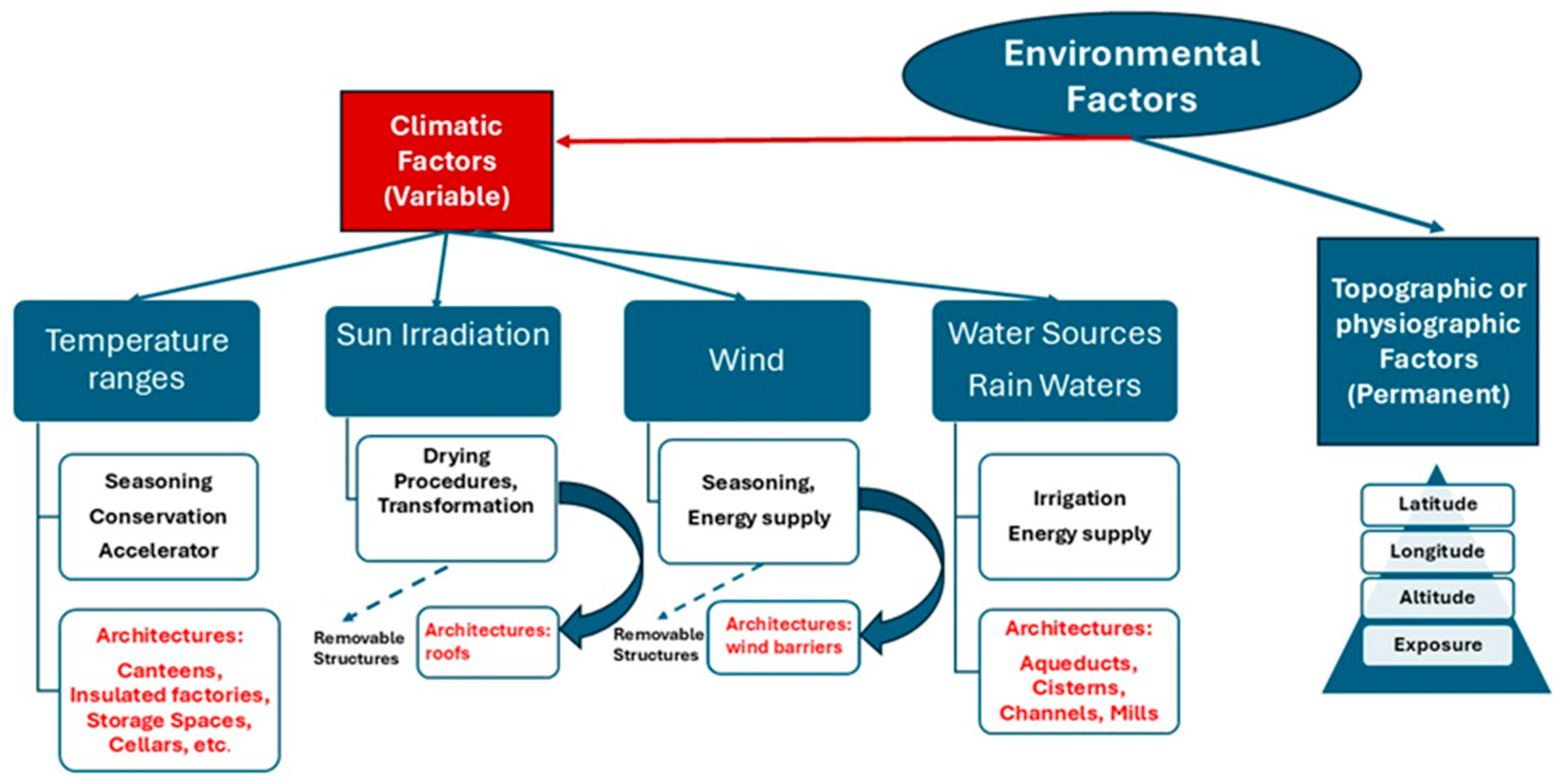
Figure 1. Climatic factors and food architecture: the methodological approach (by R.V.).
Heritage 08 00423 g001
Figure 2. Food-related architecture and climatic changes: (a) Ice cellars on the island of Ischia in southern Italy and (b) Inca microclimate architecture in the Sacred Valley of Cuzco in Peru (by R.V.).
Heritage 08 00423 g002
Figure 3. Climatic indicator: the tool (by R.V.).
Heritage 08 00423 g003
Figure 4. The pyramid of the Mediterranean diet in Italy, with the inclusion of symbols of architectures related to food whose consumption is suggested in all daily meals (green line at the bottom) (by R.V.).
Heritage 08 00423 g004
Figure 5. Italian case studies (by R.C.).
Heritage 08 00423 g005
Figure 6. Pietragalla wine district: (a) single and (b) multiple dwellings. They are both covered by vegetation, and the vine district is a significant element of the local historical landscape (by R.V.).
Heritage 08 00423 g006
Figure 7. Interior of a rock-cut wine cellar in Pietragalla featuring two basins for collecting and pressing grapes (by R.V.).
Heritage 08 00423 g007
Figure 8. Adoption of the methodological chart for climatic indicators to the Pietragalla case study (by R.V.).
Heritage 08 00423 g008
Figure 9. Different levels of enhancement for rock-cut canteens in Pietragalla: (a) abandoned, (b) restored and (c) historical setting, with a special focus on internal climate monitoring (the internal thermometer circled in blue) (by R.V.).
Heritage 08 00423 g009
Figure 10. Rock-cut oil olive oil mills in (a) Morciano and (b) Vernole (©Antonio Monte).
Heritage 08 00423 g010
Figure 11. Adoption of the methodological chart for climatic indicators to the rock-cut Apulian olive oil mills case study (by R.V.).
Heritage 08 00423 g011
Figure 12. Average temperatures during olive oil processing periods (2017–2024). Elaboration by the author from data from ARPA Apulia regarding the Galatina monitoring station [58] (by R.C.).
Heritage 08 00423 g012
Figure 13. Abandoned rock-cut oil mill around Grottaglie: (a) the entrance, (b) the pressing room, (c) millstones, (d) collection tanks and (e) a hole for pouring the olives (by R.V.).
Heritage 08 00423 g013
Figure 14. Rock-cut oil mills as drivers for cultural tourism (by R.V.).
Heritage 08 00423 g014
Figure 15. The historical pasta district of Gragnano: drying pasta in the open air near the Mills’s Valley (by R.V.).
Heritage 08 00423 g015
Figure 16. The Mills’s Valley (by R.C. and R.V.).
Heritage 08 00423 g016
Figure 17. Historical floods in the Mills’s Valley: in purple, those connected to the abandonment of historical water mills (1764—1842), in blue, those which confirm the trend [68] (by R.C.).
Heritage 08 00423 g017
Figure 18. Adoption of the methodological chart for climatic indicators to the Mills’s Valley case study (by R.V.).
Heritage 08 00423 g018
Table 1. Focus points for the enhancement of water mills (by R.C. and R.V.).
NameFocus Points for Interpretation
Porta Castello di Sopra MillLocation beside one of the gates of the Castle
Potential added value for the interpretation of the Mills’s Valley: Connection to the castle
Lo Monaco Mill
  • Reused as a pasta factory
  • Connection with religious properties (San Nicola dei Miri monastery)
Potential added value for the interpretation of the Mills’s Valley: historical reuse and history of the castle
Forma MillThe most ancient mill of the valley, built immediately below the spring.
Potential added value for the interpretation of the Mills’s Valley: the beginning of the history of the Valley and of the district
Grasso MillAccessible only from the stream bed
Potential added value for the interpretation of the Mills’s Valley: reshaping the natural river
Scomparso MillAccessible only from the stream bed
Potential added value for the interpretation of the Mills’s Valley: reshaping the natural river
Porta Castell di Sotto MillAccessible only from the stream bed
Potential added value for the interpretation of the Mills’s Valley: reshaping the natural river
Scola MillSeveral historical renovations
Potential added value for the interpretation of the Mills’s Valley: historical reuses and stratifications
La Fusara Mill
  • Very close to the stream bed
  • Small cylindrical tower
  • Reused for the breeding of silkworms
Potential added value for the interpretation of the Mills’s Valley: reshaping the natural river, technological advancements, historical reuse
La Mena MillTwo towers: the first in tuff, the second in limestone like the main building
Potential added value for the interpretation of the Mills’s Valley: different materials
Santa Lucia Mill
  • Close to the city centre
  • Reused as a slaughterhouse in the 60s
Potential added value for the interpretation of the Mills’s Valley: special organization of the district, historical reuse
Grotticella Mill
  • Named after a small cave in the rock next to the mill
  • Cylindrical tuff tower attached to the larger primary tower—built centuries earlier.
Potential added value for the interpretation of the Mills’s Valley: adoption of toponyms from natural issues, architecture stratifications
La Pergola Mill
  • Entirely made of tuff
  • The last one to be decommissioned
Potential added value for the interpretation of the Mills’s Valley: adoption of local materials, the end of the history of the Valley
Table 2. Case studies analysis: visualization of main characteristics and comparison (by R.V.).
TypeCase
Study
Food
Connected
Climatic
Issue
Connected
Type of
Management
RegionPeriodClimatic
Change
Enhancement
Water Mills
Heritage 08 00423 i001
Mills’s ValleyDurum wheatWaterAdoption as an energy source
(regular water force)
Campania13th/20th Recurrent floods of the Vernotico river due to climatic changes
(see Figure 17)
Yes
(public)
Olive Oil Mills
Heritage 08 00423 i002
Apulian
Underground Mills
(diffused)
Olive oil Temperature Optimization of temperature for fluidification
(18 °C minimum)
Apulia 15th/20th Rising winter temperatures due to the passage from “small glacial era” to “temperate climate, confirmed by current values
(see Figure 12)
Some (mostly private properties)
Pietragalla Canteen
Heritage 08 00423 i003
Pietragalla Wine DistrictWine TemperatureLogistics (canteens were just between the yards and the village)/internal climate Basilicata 16th/20thIncrease in cultivation quota due to increase in temperatures
(up to 800 m. a.s.l.)
Yes
(public/private)
Disclaimer/Publisher’s Note: The statements, opinions and data contained in all publications are solely those of the individual author(s) and contributor(s) and not of MDPI and/or the editor(s). MDPI and/or the editor(s) disclaim responsibility for any injury to people or property resulting from any ideas, methods, instructions or products referred to in the content.