Article

Using Geophysics to Locate Holocaust Era Mass Graves in Jewish Cemeteries: Examples from Latvia and Lithuania

by
Philip Reeder
1,*,
Harry Jol
2,
Alastair McClymont
3,
Paul Bauman
4 and
Michael Barrow
2
1
Center for Environmental Research and Education, Duquesne University, 600 Forbes Avenue, Pittsburgh, PA 15282, USA
2
Department of Geography and Anthropology, University of Wisconsin-Eau Claire, 105 Garfield Avenue, P.O. Box 4004, Eau Claire, WI 54702, USA
3
BGC Engineering, 980 Howe Street, Vancouver, BC V6Z0C8, Canada
4
BGC Engineering, 425 1 St SW #2600, Calgary, AB T2P3L8, Canada
*
Author to whom correspondence should be addressed.
Heritage 2024, 7(7), 3766-3798; https://doi.org/10.3390/heritage7070179
Submission received: 10 June 2024 / Revised: 12 July 2024 / Accepted: 13 July 2024 / Published: 16 July 2024

Abstract

:
A common practice used by the Germans and collaborators in World War II, as part of the Holocaust, was to use existing Jewish cemeteries as places for mass burial. Research was completed at the Old Jewish Cemetery in Riga, Latvia, the Livas Jewish Cemetery in Liepaja, Latvia, and the Zaliakalnis Jewish Cemetery in Kaunas, Lithuania. The Old Jewish Cemetery in Riga was adjacent to the Riga Ghetto and was used to bury individuals murdered in the ghetto. In Kaunas, an area of the Zaliakalnis Jewish Cemetery is devoid of grave stones, and literature sources and testimony indicate that this area was used for the mass burial of Jews from the Kaunas Ghetto and other mass killings. In Liepaja, the local Jewish Heritage Foundation believes that there are mass graves within the Livas Cemetery. Methodologies for this research include the use of a pulseEkko Pro 500-megahertz ground-penetrating radar (GPR) system. Electrical resistivity tomography (ERT) data were collected through a linear array of electrodes coupled to a direct current (DC) resistivity transmitter and receiver. Analysis of aerial photography and satellite images was also employed at each location. ERT and GPR data indicate three separate trench anomalies in the Old Jewish Cemetery in Riga. The presence of these anomalies corroborates Holocaust survivor testimony that bodies were buried in mass graves in that area. In the Zaliakalnis Jewish Cemetery in Kaunas, ERT and GPR data indicate an anomaly in the western part of the cemetery, and ERT data further indicate two other possible mass graves. In Liepaja, preliminary GPR analysis indicates an anomaly in a cleared section of the cemetery. Based on the presence of geophysical anomalies in all three cemeteries, which correlate with literature sources and Holocaust survivor testimony, there is a high probability that mass graves are present at each site. Future research directions include expanding the search areas in each cemetery, additional literature and testimony-based research, and the addition of other geophysical methodologies.

1. Introduction

This research focuses on two locations in Latvia (Riga and Liepaja) and one in Lithuania (Kaunas). The sites where research occurred in Latvia are the Old Jewish Cemetery in Riga and the Jewish section of the Livas Cemetery in Liepaja. In Kaunas, Lithuania, research was completed in the Zaliakalnis Old Jewish Cemetery (Figure 1). As part of the “Holocaust by Bullets”, the Germans created combined murder/burial sites that were distant enough from Jewish Ghettos not to arouse suspicion regarding their purpose. Burial sites were also created near the Ghettos, where Jews were imprisoned, for the quick burial of some victims, with existing Jewish cemeteries used in some cases as these very local mass burial sites.
This research’s focus and methodology falls within the realm of Geoarchaeology, which is a subfield of archaeology and geoscience, that uses techniques that are traditionally reserved for the geosciences in an archaeological context [1,2]. This research uses geophysics and air photograph and satellite image comparison and analysis to assist in systematically studying potential mass burial sites with a little-known or unknown history as related to the Holocaust [3,4,5].
Central and Eastern Europe is literally dotted with forgotten Jewish mass graves located in forests, roadside ditches, arable fields, and elsewhere [6]. The number and exact location of many remain unknown. In Poland, as part of the Rabbinical Commission for Jewish cemeteries, working with the Chief Rabbi of Poland and within the Jewish law of Halacha which prohibits opening graves and moving the remains of the dead, investigations are being completed using noninvasive technologies like ground-penetrating radar (GPR) and electrical resistivity tomography (ERT) [7]. Similarly, the research presented in this article uses these noninvasive technologies and has been approved by chief Rabbis in Riga, Liepaja, and Kaunas.

2. Background

According to 2023 estimates, Latvia currently has the largest Jewish community in the Baltic States (Estonia, Latvia, and Lithuania). The approximately 4500 Jews currently living in Latvia trace their roots to survivors of the Holocaust, Jews who fled to the Soviet Union (USSR) to escape the 1941 German invasion and later returned, and Jews who immigrated to Latvia more recently from the former USSR. Historically, Latvian Jewry prospered until World War I, when the majority of Latvian Jews fled the country, with less than half returning after the war. During the interwar years (between World Wars I and II), Latvia was an important center of Jewish life and learning until Shoah [8]. Shoah is the Hebrew word for “catastrophe,” which is synonymous with the term Holocaust, which is used in English-speaking countries to refer to the killing of nearly six million Jews in Europe by Nazi Germany and its collaborators during World War II [9].
Just prior to the German occupation of Latvia in World War II, the Jewish population was approximately 85,000, with 40,000 living in Riga, 10,000 in the Liepaja area, and the others scatted mainly in small communities around the country. By 10 July 1941, the entire territory of Latvia was under German control [10]. An estimated 15,000 Jews had fled ahead of occupation, crossing into Russia, so with borders impassable after the arrival of the Germans, about 70,000 Jews remained in Latvia. In anticipation of German occupation, many Jews were murdered before and during their arrival by local Latvians. Throughout July and August 1941, the majority of the Jewish population of the cities and provincial towns was systematically eradicated. In some instances, Jews were locked in synagogues and burned alive or marched to nearby cemeteries and forests, where they were shot and buried in mass graves. When the German forces fled Latvia prior to the return of the Soviet Red Army in 1944, the Holocaust had killed 90% of Latvia’s Jewish population [11].
Circumstances in Lithuania are analogous to what transpired in Latvia. According to 2023 estimates, approximately 2400 Jews are currently living in Lithuania. Since Lithuania was home to a historically significant and influential Jewish community, many Jews worldwide can trace their roots back to the region. Lithuanian Jews (Litvaks) at one time accounted for about 10% of the total population of Lithuania [12]. The pre-war Jewish population was approximately 160,000, or seven percent of the country’s total population. Following the start of World War II, Lithuania’s Jewish population swelled to approximately 250,000 persons due to the influx of refugees from German-occupied Poland. In June and July 1941, Germany occupied Lithuania. Once in control, the Germans and collaborators began the mass murder of the Jewish population, killing 90 percent of Lithuania’s Jews by the time Soviet troops reoccupied Lithuania in the summer of 1944 [13,14].

2.1. Related Research

Other studies have been completed at Holocaust sites to reveal the nature and extent of the sites, and in some cases the location of mass graves, using noninvasive technologies at, for example, the German Nazi Labor Camp Treblinka in Eastern Poland [15]. During the initial phase of this project, Dr. Sebastian Rozycki from the Warsaw University of Technology used existing maps, witness statements, and spatial data gathered from current satellite images and German World War II-era air photographs to establish the relationships between these data and camp benchmarks like building placements, walking routes, and gate locations. A second phase of the project involved the use of GPR to reveal new insights into the camp that the Germans worked so hard to destroy when it was abandoned in 1943.
Debate about the possibilities of using interdisciplinary methods, including the use of noninvasive geophysical technologies, in investigations of labor and concentration camps from World War II is well embedded in a mixture of archaeological subdisciplines, including combat archaeology, war archaeology, interment archaeology, and public archaeology [16]. Field investigations using noninvasive techniques are becoming more common practices, and in recent years, numerous archeological research projects have taken place, including a research project prepared by The Historical Museum of Krakow (Poland) and the investigations of the Rabbinical Commission for Jewish Cemeteries, in the vicinity of the Krakow-Plaszow Labor and Concentration Camp [16].
At Ponary, near Vilnius, Lithuania [3], the Germans buried the remains of approximately 70,000 Jews and 30,000 other individuals who were deemed to be undesirables, like the Roma (Gypsies), Jehovah’s Witness members, and gay men, for example. This research better illuminated the site’s layout, the location of additional mass graves that had not yet been memorialized, and the confirmation of an escape tunnel that was used by Jewish slave laborers who were charged by their German captors with digging up the 100,000 bodies, burning the remains, and then burying the ashes. Facing sure death when this grim task was completed, they chose to dig an escape tunnel. ERT and GPR were used at Ponary to pinpoint the location and route of the remains of this escape tunnel, and the location of a previously undiscovered burial pit [3].
At Heereskraftfahrpark (HKP) 562 Forced-Labor Camp in Vilnius [17], research was completed using ERT and GPR to find the entrance to hiding places where Jews took refuge before the camp’s liquidation and certain death. Additionally, the location of the burial trenches where the Jews who were found in their hiding places, and subsequently murdered, and were initially buried, was found, as was the mass grave to which these remains were moved by the Jews who survived the liquidation of the camp.
At Fort IX in Kaunas, Lithuania [18,19,20], the Germans and local collaborators (Lithuanian police auxiliaries) murdered and buried, in mass graves, 9200 Jews who were previously housed in the Kaunas Ghetto. Research at this site again used the noninvasive geophysical techniques of GPR and ERT to determine the nature and extent of these mass graves. Additionally, data were collected related to the possible route Jewish prisoners followed as part of an escape attempt.
In Raylivka village in Ukraine, archival data, combined with geophysical methodologies, and interpretations from 1944 German air photographs for the region were used to determine the location of mass graves. Field work using various geophysical techniques included metal detecting and magnetic survey to detect World War II artifacts, as well as ERT and GPR. As a result, a large number of artifacts from World War II were found, and the boundaries of mass graves initially defined in air photographs were confirmed and refined [21].
Also, in Ukraine, the efficacy of using forensic and archaeological techniques at genocide sites, including those related to the Holocaust, was examined [22]. Over the past 40 years, investigations of mass graves and other sites connected to the events of the Holocaust have developed significantly, with forensic archaeology now widely accepted as a subdiscipline defined as the application of archaeological theory and methods to the resolution of medico-legal and humanitarian issues that can be associated with the Holocaust [22].
Lamsdorf, a prisoner-of-war (POW) and resettlement camp in Poland, operated near that village from the times of the Franco-Prussian War (1870-71), through World Wars I and II, finally closing in 1946 [15]. As part of understanding the history and heritage of British POWs held at this place, noninvasive archaeological work was carried out in 2022. Historical aerial photographs, plans, and sketches were used to gain initial insights into the camp, which was then refined using airborne laser scanning (LiDAR) to carefully document the diversity of camp landscapes, including rows of unmarked single graves in what was most likely the camp cemetery. Trenches of various lengths, about 1.5 m wide and from about 0.3 m to about 1 m deep, were also identified and concluded to be locations that served as a shelter in the event of air raids, and not graves/mass graves [23].

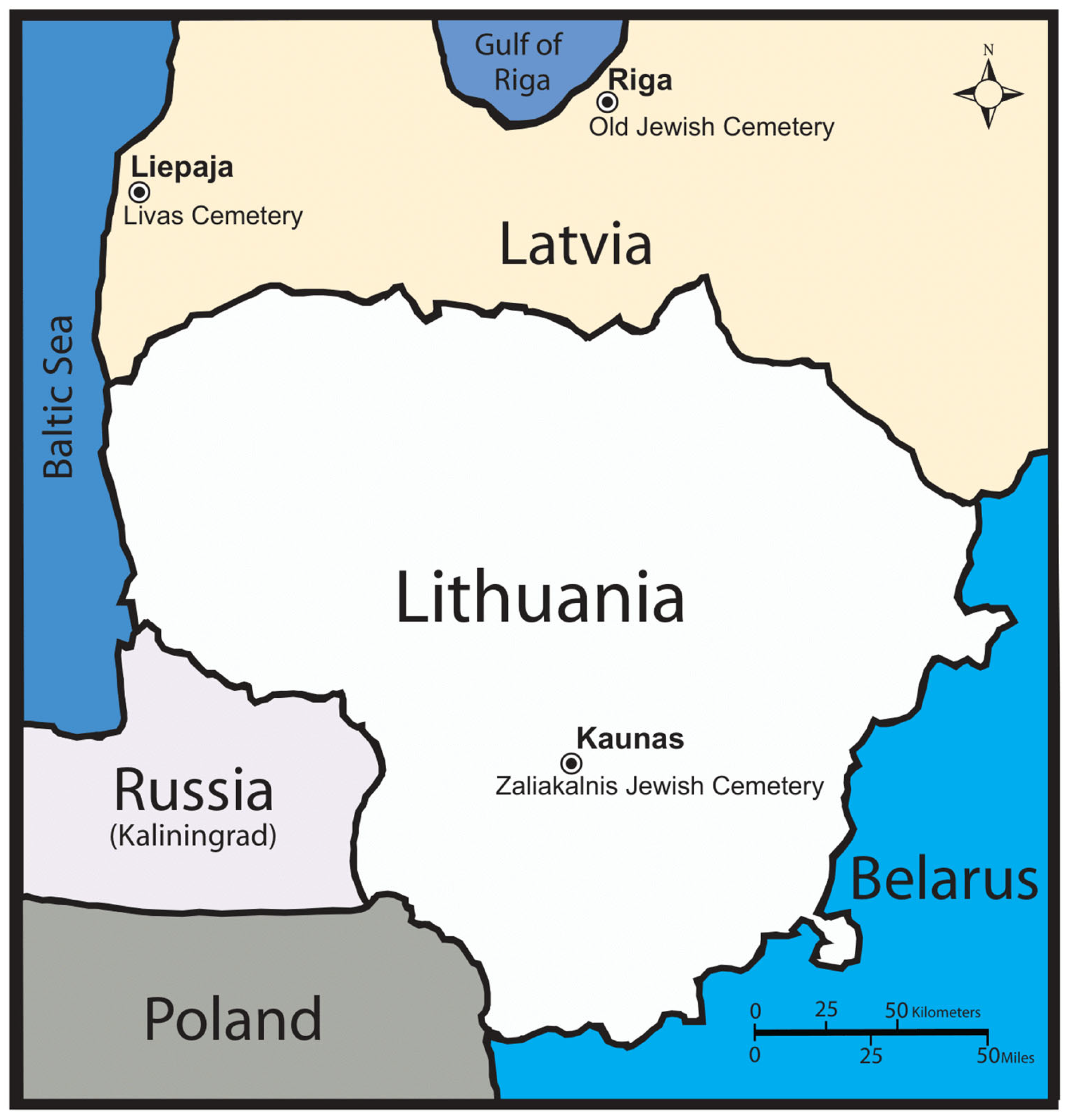
2.2. The Final Solution in Latvia and Lithuania
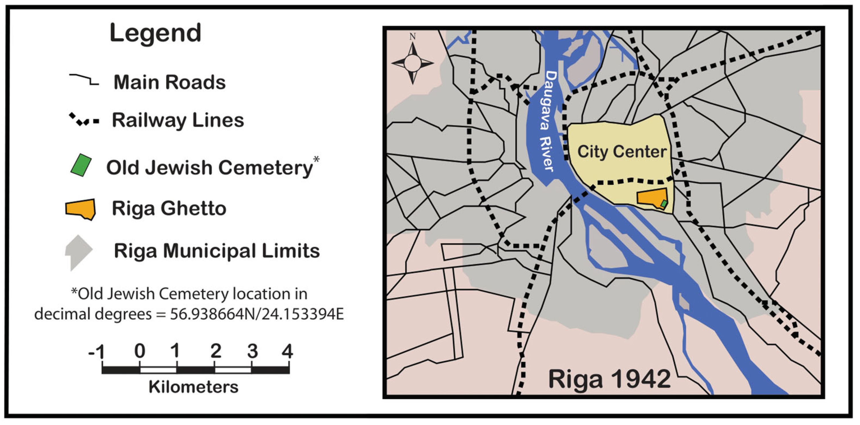
Nazi Germany’s plan, which they deemed the “Final Solution to the Jewish Question”, was intended to murder the entire Jewish population of Europe [24,25]. After taking power in the 1930s, Germany, following the Nazis’ ideology, initially harassed and intimidated the Jews, but over time, their approach to the “Jewish Question” became increasingly violent. After occupying Latvia and Lithuania in 1941, the Germans and local collaborators began to murder the Jewish population systematically, primarily by firing squad. These actions were deemed the “Holocaust by Bullets”, and it was not until March 1942 that extermination camps like Sobibor, Treblinka, and Belzec (all in Eastern Poland), where Jews were killed using gas, were operational [26].
During the Holocaust, the creation of ghettos was an essential component of Nazi Germany’s process to marginalize, persecute, and ultimately destroy Europe’s Jews. These Ghettos separated Jews from the non-Jewish population and concentrated them for later deportation and mass murder. Living conditions for the Jews imprisoned in these Ghettos (Riga, Liepaja, and Kaunas (also known as Kovno) in the context of this research) were appalling [27].

2.2.1. Riga, Latvia

German Einsatzgruppen (mobile killing units), together with local Latvian collaborators, shot several thousand Jews shortly after entering the city in June 1941. A ghetto was established in mid-August in the southeastern area of the city, which, by October 1941, imprisoned approximately 30,000 Jews (Figure 2). In late November and early December 1941, the Germans perpetrated a ruse that announced that the majority of ghetto inhabitants would be relocated to new locations further to the east. As prescribed in this plan, on 30 November and 8 and 9 December, at least 25,000 (and perhaps as many as 30,000) Jews from the Riga Ghetto unknowingly went to the nearby Rumbula Forest, nine kilometers southeast of the Ghetto, to be shot by the German Schutzstaffel (SS), German police units, and Latvian collaborators [28,29]. The Schutzstaffel (SS), which numbered approximately 250,000 total troops, were dispersed throughout German-occupied areas. Among their many duties, they were responsible for mass shootings, anti-partisan warfare, and supplying guards for German concentration camps. Specifically, some troops specialized in brutalizing and murdering individuals, as well as carrying out the daily operation of Hitler’s death camps [30].
According to testimony by Steven Springfield (collected on 30 March 1990), who as an 18-year-old was imprisoned in the Riga Ghetto, the SS entered the Ghetto on 30 November and again on 8 and 9 December 1941, to remove inhabitants to be murdered and buried in mass graves in the forest at Rumbula [31]. This clearing of Latvian Jews from the Ghetto took place to create room in the Ghetto for German Jews who were being brought to Riga on trains from Germany [32]. At Rumbula, the victims were forced to disrobe, marched to the edge of a pit that Soviet prisoners of war had previously dug, and were then shot and buried in the pit, which also served as a mass grave. Springfield notes in his testimony that 15,000 Jews from the Ghetto were massacred in just one day at Rumbula. Ghetto inhabitants who resisted or were too old or infirm to make the trip to Rumbula were murdered in the Ghetto [32]. Jews returning from work outside the Ghetto, who had not been caught up in the massacres, were conscripted to bury, in the Old Jewish Cemetery, those who had been murdered in the Ghetto during these actions [33]. Steven Springfield and his brother, because they were young and nondisabled, were sent to a work camp rather than the Rumbula Forest [31].
The Old Jewish Cemetery is located within the territory that the Riga Ghetto occupied. The original cemetery dates back to 1725, and was extended in 1868, and again in 1896 [34]. Jews who had been randomly executed within the Ghetto, who had committed suicide, or had been murdered in the Ghetto during the Rumbula actions were buried (in mass graves) in the Old Jewish Cemetery, with the total number estimated to be approximately 2000 [35]. The cemetery is purported to contain separate mass graves for the November/December 1941 victims and other actions that took place in late October 1942. On October 29, 1942, all the members of the Jewish Ghetto Police were summoned to the so-called Blechplatz (which translates to “sheet metal place” in English). They were shot by the German Security Police [35]. In joint testimony by Malvina Reinigerova and Melanie Pragerovamade, made before and certified by the Juedischer Gemeinderat der Tschechischen und Maehrischen Provinzen (translated as Czech and Moravian Jewish Community Council), it was stated that Obersturmfuhrer (translated to English from German as Senior Storm Leader, which was a German paramilitary rank that the SS used) Krause, Commandant of the Riga Ghetto, indiscriminately shot or ordered prisoners shot, including these Ghetto Police. The prisoners were shot and buried in the Old Jewish Cemetery or were transported there for burial after being shot elsewhere [36]. After World War II, any remaining tombstones in the cemetery were stolen, and the high brick walls surrounding it were demolished [34].

2.2.2. Liepaja, Latvia

Liepaja is located in western Latvia. It is a port city directly adjacent to the Baltic Sea (see Figure 1). A Jewish community was established in Liepaja in the early 1800s. By the end of the 19th century, approximately 9400 Jews were living in Liepaja, about 14% of the city’s population [37]. On 29 June 1941, the Germans occupied Liepaja and began carrying out political arrests and murders with the collaboration of the Latvian “Self-Defense” organization. The first murder operation took place on the first day of occupation, when a group of Jews were shot and buried in Soviet-dug anti-tank ditches (trenches) in Rainis Park (Figure 3). The eventual victims were placed in columns of 25–30 people and brought to Rainis Park, where they were murdered and buried over six to seven days. After two to three weeks, when the stench from the park had become overwhelming because the layer of earth covering the corpses was too thin, the Germans ordered Jewish residents to exhume the bodies, transport them in wagons, and rebury them in the Jewish section of the Livas Cemetery. Estimates of the total number of victims vary from several dozen to about 300 according to a Soviet Extraordinary State Commission Report [38]. These activities marked an end to the murder and burial in Rainis Park. Beginning on 7 July 1941, the dunes in the vicinity of the port and the Liepaja Lighthouse were used for the murder and burial of Jews (Figure 3).
In 1993, on the site of the presumed reinternment of the victims from Rainis Park, a granite stone with the Star of David and an inscription in Hebrew and Latvian, “To the Jews of Liepaja—Victims of Fascism-1941–1945”, was placed in the Jewish section of the Livas Cemetery. In 2004, next to this memorial stone, a memorial wall was installed with 6428 names of Jews of Liepaja who died during the Holocaust or in Soviet correctional camps [39,40]. Based on information provided by Ilana Ivanova, from the Liepaja Jewish community, and affiliated with the Liepaja Jewish Heritage Foundation, preliminary research was completed in the Jewish section of the Livas Cemetery in 2023. Ground-penetrating radar (GPR) was used to determine the possible location of the mass grave associated with the victims of the Rainis Park massacres, and if any other potential mass graves exist at this site (Figure 4). The area in the southeast corner of the Jewish section of the cemetery was pointed out as a potential GPR target because it is devoid of headstones and contains numerous mounds and depressions. GPR data were collected from a 20 m by 13.5 m GPR grid between two earthen mounds in this area.

2.2.3. Kaunas, Lithuania

Between 1920 and 1939, Kaunas, located in central Lithuania (see Figure 1), was Lithuania’s capital and largest city. The Jewish population in 1939 was approximately 32,000, which comprised one-fourth of the city’s total population. The city had nearly 100 Jewish organizations, 40 synagogues, five daily Jewish newspapers, a Yiddish and Hebrew school network, and scores of Jewish-owned businesses [41]. In June 1940, the Soviet Union occupied Lithuania, and a year later, Germany attacked the Soviet Union, and on 24 June 1941, Kaunas was occupied by German forces. Many Lithuanians welcomed the German forces, seeing them as liberators from Soviet occupation. Local paramilitary groups held the belief that the Jews played a significant role in the Soviet repression of Lithuania, so when the Soviets fled and before the Germans had entered the city, Lithuanian mobs had already begun to kill Jews [41].
German collaborators started anti-Jewish pogroms in Kaunas beginning on 25 June 1941. Pogrom is a Russian word meaning “to wreak havoc or demolish violently”, which, in the context of events that transpired in Kaunas (and elsewhere), refers to violent attacks by local non-Jewish populations on Jews [42]. Over 1000 Jews were murdered over the next few days (beginning on 25 June 1941) in this first pogrom in German-occupied Lithuania. The most infamous incident related to this pogrom occurred in what was later known as the Lietukis Garage Massacre, which was perpetrated on 27 June 1941, before the invading Germans had even set up their administration. During this massacre, 40–60 Jewish men were killed with shovels, iron bars, or other barbaric methods [43]. A crowd had gathered to watch and cheer this spectacle, during which parents lifted their children onto their shoulders to catch a glimpse of the atrocities that were taking place and one of the foremost perpetrators, who was deemed the death dealer of Kovno [44].
Colonel Lothar von Bischoffshausen, a Panzer Division Commander who had just arrived in Kaunas, witnessed the events at the Lietukis Garage, and he subsequently provided a detailed account of what he observed [44]. In summary, he arrived in Kovno (Kaunas) on 27 June 1941. While patrolling the city, he noticed a cheering crowd of men, women, and children gathered alongside a gas station to watch what was happening in the adjacent yard. At first, he thought it was a victory celebration or some sporting event. However, when he asked a bystander what was occurring, he was told that the “death dealer of Kovno” was at work making sure that all “traitors and collaborators” received a fitting punishment for their treachery [44].
When Colonel von Bischoffshausen drew closer, he witnessed a display of brutality that he stated was unparalleled by anything he saw in combat during two world wars. Standing in the yard was a young man around 25 years of age, leaning on a long iron bar, and around his feet, fifteen to twenty men lay dying or already dead. A few feet away stood a group of men guarded by “the dealers” co-conspirators. Every few minutes, “the dealer” signaled with his hand, and another victim came forward to face sure death from multiple blows from the iron bar he held in his hand. Each time he struck a blow to his helpless victims, it drew clapping and cheering from the crowd [44].
Residents in the buildings around the Zaliakalnis Cemetery, approximately 1.8 km from the Lietukis Garage, gave testimony that they witnessed trucks arriving with corpses that were buried there in late June of 1941 [45]. In 2017, Kaunas Jewish Community chairman Gercas Zakas showed our research team an area in the Zaliakalnis Jewish Cemetery where an Israeli archaeologist, five years prior, determined, by methods not known to us, that there was a mass grave. It is postulated that this may be the place where the victims of the Lietukis Garage Massacre were buried (Figure 5 and Figure 6).
The Zaliakalnis Jewish Cemetery is just one of many locations in which murdered Jews were buried in mass graves in and around Kaunas. In early July 1941, German Einsatzgruppen (mobile killing units) and their Lithuanian auxiliaries began systematic massacres of Jews in several of the forts (primarily Fort IX), which had been constructed under the Russian Empire in the late nineteenth century for the defense of the city (Figure 6). These auxiliaries, under the supervision of the Germans, shot thousands of Jewish men, women, and children [46]. At Fort IX, mass murder and burial occurred from October 1941 to August 1944, with October 1941 being an exceptionally deadly period. On October 4th, 1845 Kovno Jews, and on 29 October, 9200 Jews brought from other European countries were imprisoned, murdered, and buried at Fort IX, with the total number who met this fate at Fort IX estimated at nearly 50,000 [47,48].
Many of the victims of these atrocities in Kaunas were first confined in the Ghetto. An order issued by the German occupiers on 11 July 1941 stipulated that between 15 July and 15 August, all the Jews in the city and its suburbs were to move into a ghetto to be set up in the Slobodka section of Kaunas (Figure 6). In late August 1941, the Kaunas Ghetto contained 29,760 people [49].

3. Materials and Methodology

3.1. Research Design

The main objective of this project is to use GPR, ERT, air photo assessment, literature sources, and testimony data to add information to the existing base of knowledge about (1) the mass burial of Jews in the Old Jewish Cemetery who were murdered in the Riga Ghetto as part of the 30 November and 8 and 9 December 1941, actions which led to nearly 30,000 Jews being murdered and buried in mass graves in the Rumbula Forest; (2) The murder and burial of Jews from Liepaja in the Jewish section of the Livas Cemetery, including the exhumation and reburial of Jews murdered and initially buried in Rainis Park; (3) The burial of Jews associated with the Lietukis Garage Massacre, and possibly other German mass murder and burial actions, in mass graves in the Zaliakalnis Cemetery in Kaunas.
The questions that this research intends to answer are below.
  • Can Ground-Penetrating Radar (GPR) and Electrical Resistivity Tomography (ERT) successfully identify subsurface anomalies at the Zaliakalnis, Old Jewish, and Livas Cemeteries?
  • Will the GPR and ERT data, in conjunction with air photo assessment, both indicate similar anomalous features at the same location within the cemeteries?
  • Do the identified anomalies possess characteristics that can be correlated with mass graves from the Holocaust?
  • Do these anomalies correlate with information from literature sources and testimony-based information for the three sites?
  • Will the results from this research provide the impetus for future research at these and other Jewish Cemeteries in Latvia, Lithuania, and beyond?
The interpretation of the data collected for this project will be used to provide answers to the five stated research questions. The specific answers to each of these research questions are summarized in the Section 5.

3.2. Methodological Background

Multiple methods were employed to collect, analyze, and assess data related to the research completed at the Old Jewish, Livas, and Zaliakalnis Cemeteries. Air photographs from the German Flown Aerial Photographs, 1939–1945 series, from the United States National Archive collection were searched to locate air photos for the three research sites. An air photograph of the Old Jewish Cemetery in Riga was located, but the site was densely wooded, and the tree canopy obscured the view of features associated with the cemetery. In Liepaja, the flight path did not cross over the Livas Cemetery, with the closest flight path being approximately 200 m to the northwest. Two flight paths did pass over the Zaliakalnis Cemetery. Satellite images for multiple years were obtained from Google Earth [50] and ESRI World Imagery, which is available online for Latvia through the Vēsturiskās Vemes (Historical Lands Office), which is part of the Centrālā Statistikas Pārvalde (Central Statistical Office) (https://vesture.dodies.lv/#m=10/56.91950/24.16786&l=E) accessed on 15 April 2024. The noninvasive geophysical techniques Ground-Penetrating Radar (GPR) and Electrical Resistivity Tomography (ERT), which are frequently used in archaeological studies to assess the subsurface without undertaking the destructive process of excavation, were used at these three sites as well [51,52,53,54,55].
A Google Earth image (2022) of the Jewish portion of the Livas Cemetery (see Figure 4) highlights the following: (1) the location of the memorial wall and the mass burial memorial, (2) a photograph of the mass burial memorial, (3) the area in the southeastern part of the Jewish section of the cemetery that does not contain grave markers, and (4) the location of a 20 m × 13.5 m GPR grid. Figure 7 also contains a 2022 Google Earth image of the Jewish portion of the Livas Cemetery. The perimeter of the Jewish portion of the cemetery, which was designated visually using this image and onsite ground truthing, is highlighted in red, as are two anomalous topographic features (obvious mounds which were observed during prior visits to the site) and the GPR grid placed between the mounds. The GPR grid was placed between the mounds, working on the assumption that the mounds exist because a hole or trench was excavated at this location. Following this line of thinking, the mounds are composed of soil removed from this hole or trench that was not returned to the excavation when the feature was refilled. Therefore, any anomalies associated with this grid could indicate that the location was potentially used as a mass burial site. The space occupied by the bodies put into the excavation prevented all the soil removed from the excavation from being returned, thus leaving behind these mounds to the north and south of the GPR grid. The lower image in Figure 7 is a ground-level side view of the mounds and the GPR grid located between the mounds.
Similarly, two ERT transect lines and two GPR grid locations associated with the Old Jewish Cemetery in Riga are plotted on a 2022 Google Earth satellite image. On a 2017 (the year the data were collected) Google Earth satellite image of the Zaliakalnis Cemetery in Kaunas, Lithuania, the location of two ERT lines and one GPR grid are plotted. The ERT lines and GPR grid locations were also plotted on a 1944 Luftwaffe air photograph of the cemetery.

3.3. Data Collection

3.3.1. Ground-Penetrating Radar (GPR)

Generally, the GPR technique used in this study is based on the propagation and reflection of pulsed high-frequency electromagnetic (EM) energy [56,57]. This field technique provides near-surface, high-resolution, near-continuous profiles of archaeological sites [58,59,60]. GPR has become a popular method for investigating shallow subsurface features because of the above properties and the availability of portable, robust, digital radar systems. Publications resulting from past investigations by the researchers involved in this project, as well as others, have shown that GPR is a valuable, efficient, and effective research methodology in archaeological studies [61,62,63,64,65,66,67,68]. The GPR acquisition system Sensors and Software pulseEKKO™ was used for this project [69], and the GPR profiles were collected with 500-megahertz (MHz) antennae.
The grid from which data were collected in the Livas Cemetery was 20 m × 13.5 m and oriented north–south (see Figure 4 and Figure 7). The GPR grids in the Old Jewish Cemetery were 100 m × 20 m (GPR grid 1) and 60 m × 25 m (GPR grid 2) in size, and both grids were oriented southwest–northeast. GPR grid 1 was collected over two field seasons (2021 and 2022) and comprises several adjacent grids merged under the designation GPR Grid 1. Data for a 10 m × 12.5 m portion of the northeast section of grid 1 was collected at a closely spaced interval (0.02 m step size) within this grid in 2022. The step size in the remainder of the grid, from which data were collected in 2021, was 1.0 m, so the resolution of the data is much lower. The GPR grid in the western section of the Zaliakalnis Cemetery in Kaunas was 25 m × 20 m in size and was oriented southwest–northeast.
Specifically, regarding the GPR techniques used in this research, the antennae separation for all these grids was 0.5 m, and to provide good horizontal resolution, the step size was 0.02 m [61,64], except for a significant portion of grid 1 in the Old Jewish Cemetery, as described above. A carrier transport system was employed to aid in data collection time. Each trace was vertically stacked with an appropriate sampling rate. The digital profiles were downloaded, saved to an external hard drive, processed, and plotted using pulseEKKO, GFP Edit, and EKKO_Project software packages [69]. Basic processing included automatic gain control (AGC), signal saturation correction, trace stacking (horizontal averaging), and point stacking (running average), as well as other routines. Near-surface velocity measurements were calculated. The GPR profiles were corrected for topography using a Topcon Total Station and a Topcon Laser Leveler. The application of radar stratigraphic analysis (distinct signature patterns) on the collected data provided the framework to investigate lateral and vertical geometry and the stratification of the assessed archaeological features [64,65]. Once data collection was completed, and elevation data were added to the data set, the data set was then processed, and both plan view and cross-sectional depictions of the data were created. The elevation data are used to topographically correct the GPR data, thus enhancing their accuracy.

3.3.2. Electrical Resistivity Tomography (ERT)

Generally, ERT is a technique for mapping the distribution of subsurface electrical resistivity (or its inverse conductivity) in a cross-sectional format [70,71,72]. The objective for completing a total of five ERT survey profiles in the three Jewish cemeteries in this research was to determine if the potential mass graves could be mapped below the ground surface using an electrical technique, and whether any other changes in soil properties could be distinguished that may be associated with events before, during, or after the execution and burial of the victims.
Specifically, as part of the ERT process, resistivity data are collected through a linear array of electrodes coupled to a direct current (DC) resistivity transmitter, receiver, and electronic switching relays. The spacing between electrodes controls the horizontal and vertical resolution of the data (smaller spacing results in higher horizontal and vertical resolution). Similarly, the array’s length controls the investigation depth (more extended arrays yield greater investigation depths). Data collection is sequential and automated, taking advantage of all possible combinations of current injection and potential measurement electrodes [73]. First, downloaded data are processed and analyzed on a laptop computer, often in the field. Then, the data are inverted (i.e., modeled) using a two-dimensional (2D) finite difference or a finite element inversion routine using RES2DINV tomographic “inversion” software, which iteratively calculates the 2D (or cross-sectional) model of the ground that best fits the data that have been measured [74]. The final 2D cross-sectional product (known as a “true” geoelectric section) plots resistivity (in Ohm-m) or conductivity (in milliSiemens per meters [mS/m]) versus depth [75,76].
All ERT data were acquired for this research using a minimum electrode spacing of 1.0 m, enabling a depth of investigation of at least 5 m below ground surface (mbgs). These surveys utilized an ABEM Terrameter LS resistivity system, and the data were acquired using an expanded gradient acquisition sequence [3]. At the heart of the system is a transmitter powered by a 12 V battery. The electrodes inserted into the ground are connected to the transmitter unit via a multicore cable. Individual measurements are then obtained by sending electrical current from the 12 V battery to a pair of injection electrodes, and the resulting voltage is measured on a pair of separate reception electrodes. The five ERT profiles acquired as part of this study used an expanded gradient acquisition sequence, to optimize the lateral and vertical resolution of the desired subsurface targets (mass graves). Multiple-gradient arrays of the type used in this research are more efficient to collect with the multichannel systems that were used in this research, and they have a lower sensitivity to noise than dipole–dipole arrays [3].
Data processing included removal of any negative values and obvious outliers. The ERT methods used in this research yielded a cross section showing changes in the soil resistivity. All ERT inversions were calculated using L2-norm smoothness constraints, and model cell widths were set to equal half (0.25 m) the minimum electrode spacing (0.5 m). For each inverted profile, convergence was reached after no more than five iterations, and root-mean-square errors were in the range of 3–8% [3].
IP (electrically induced polarization) is a second type of electrical imaging survey collected simultaneously and with the same equipment as the ERT survey [77,78]. While resistivity surveys the subsurface in terms of its unit volume resistance to the passage of electrical current, IP images the subsurface in terms of its changeability, which is loosely analogous to the ability of the subsurface to store an electrical charge [79]. Resistivity measurements take place while current passes through the subsurface. During IP measurement, no current is actively transmitted through the subsurface materials. Chargeability, measured in milliseconds (msec), represents the area under the voltage curve that rapidly decays after current transmission ceases [80]. A chargeability section can be inverted (i.e., modeled) from the acquired raw IP data. Generally, sand and silt will have zero chargeability, and clay may have a very low but measurable chargeability of a few msec. Metal objects in the subsurface can have a chargeability of tens, hundreds, or thousands of msec, depending on the size, surface area, and burial depth [81]. Hence, an IP survey can detect metal objects buried in the subsurface along the five ERT lines along which data were collected in this study.

3.3.3. Simultaneous Localization and Mapping (SLAM) and Land Surveying

SLAM technology was also used to create a high-resolution, detailed topographic map of Riga’s Old Jewish Cemetery site. This technology was unavailable at the Livas and Zaliakalnis Cemetery sites. SLAM allows the detailed mapping of an area while keeping track of the device’s location within that area [82,83,84]. This cutting-edge technology allows detailed map construction of large areas in a much shorter time. Using SLAM software version 2.3.0, the GeoSlam device can simultaneously localize (locate itself in the map) and map (create a virtual map of the location) using SLAM algorithms [85]. We utilized a LiDAR-based SLAM system with a laser sensor to generate a 3D map of the Old Jewish Cemetery site (see Figure 8). LiDAR (Light Detection and Ranging) measures the distance to an object (a tree, fence, or building) by illuminating the object using an active laser pulse [86]. This LiDAR-based system proved to be a fast and accurate method for drawing a detailed topographic map of the Old Jewish Cemetery. This map was then visually analyzed to detect any topographic features potentially correlated with mass burial locations in the cemetery.
Additionally, a Topcon Total Station was used to collect survey data (x, y, and z data), which assisted in correctly placing the GPR grid and ERT line locations on Google Earth and ESRI World Imagery images for the study sites [87]. The total station and a Topcon Laser Leveler were also used to determine elevational relationships amongst and between GPR grids and ERT transect lines, and to correct the GPR data vertically [88].

3.3.4. Literature Sources and Survivor Testimony

Written literature sources and summaries of oral testimony were also components of this research, to assist in understanding the historical background and significance of the study sites [89,90,91]. As with many places where the Germans perpetrated atrocities, many witnesses were murdered and could not write down or tell their stories. Yad Vashem (the World Holocaust Remembrance Center), the United States Holocaust Memorial Museum, and the Wiener Holocaust Library, to name a few, contain hundreds of millions of pages of documents, photographs, and video, audio, and written testimonies [92]. Relevant to this research is the testimony given by Steven Springfield about the Riga Ghetto and Rumbula Forest, which was accessed via the United States Holocaust Memorial Museum (USHMM) website [31]. Malvina Reinigerova and Melanie Pragerovamade gave testimony related to the murder of Jews in the Riga Ghetto and their mass burial in the Old Jewish Cemetery (accessed through the Wiener Holocaust Library website) [36]. Testimony from the State Extraordinary Commission for Investigation of German War Crimes in the Soviet Union, 1943–1945 (accessed through the Yad Vashem Archives), provided information about the mass murder and burial of Jews in Rainis Park in Liepaja and the subsequent exhumation and reburial of these victims in the Livas Cemetery [38]. In Kaunas, the testimony of Colonel Lothar von Bischoffshausen (accessed through a secondary source: the Jerusalem Post) [44], a Panzer Division Commander who has witnessed the Lietukis Garage Massacre, shed light on the atrocity that took place there. What was stated in these testimonies and related reports greatly influenced where geophysical analysis took place at the study sites. They linked this invaluable cultural/historical resource with geoscience techniques that predicated eventual discoveries at the Old Jewish, Livas, and Zaliakalnis cemeteries.

4. Results

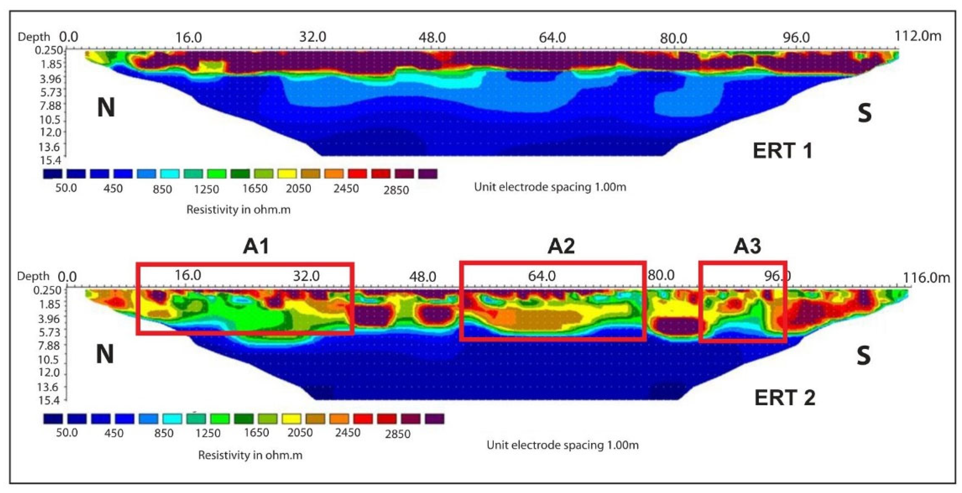
4.1. The Old Jewish Cemetery in Riga

Based on the assessment of literature sources and testimony-based information, it was determined that there is a distinct possibility that the remains of Jews murdered in the Riga Ghetto, as part of the German SS operation that transported approximately 30,000 Jews to the Rumbula Forest to be murdered and buried in mass graves, are buried in the Old Jewish Cemetery. GPR, ERT, and SLAM were used to collect data at the site to assist in verifying this possibility.
The plot created using the SLAM handheld LiDAR system is presented in Figure 8. This topographic map has a relief of seven meters, with the hotter colors (yellow to orange to red to purple) representing progressively higher elevations. As evidenced in this map, the center part of the cemetery possesses the highest elevation, with the topography decreasing rather proportionally towards the perimeters. In these perimeter areas, the topography is flatter, as evidenced by the progression of cooler colors (grading from yellow to green and finally blue).
Testimony and literature-based sources both point to the fact that Jews from the Ghetto were buried in mass graves in the Old Jewish Cemetery. Based on an oral communication with Ilya Lensky, the current director of the Museum of the Jews in Latvia, who is very familiar with the numerous testimonies of Marģers Vestermonis (Westerman), the former director of the Museum of the Jews in Latvia, information relating these testimonies to mass burials in the Old Jewish Cemetery was uncovered [93]. As a 16-year-old, Vestermonis witnessed bodies of Jews murdered in the ghetto as part of the Rumbula operations [29,30,31] being brought into the cemetery for mass burial. These mass graves were most likely located in the relatively flat, as indicated by the SLAM data used to create Figure 8, area along the northwestern perimeter of the cemetery [93]. Our explorations were therefore focused in that area, as evidenced by the two ERT lines and GPR grid along this northwestern boundary.
Based on this presumption that burial trenches were dug along the northwestern perimeter of the cemetery, bodies were therefore placed in these trenches. The trench was then refilled with the soil that was removed to create the trench, and the decomposition of the bodies and subsequent settling of the overlying soil may have left behind linear depressions on the land surface that would be indicated by the shape of the contour lines on the map, but would not be visible to the naked eye onsite. Detailed inspection of the topographic map in Figure 8 indicates that no anthropogenically derived linear depressions are visible based upon a detailed visual assessment of the contour lines. The fact that the cemetery grounds are very disturbed because they underwent a transition from an active cemetery prior to World War II, to a park wherein all gravestones have been removed, may account for this lack of any surface lineation on the topographic map, even if these burial trenches do exist at this location.
Figure 9 is an ESRI World Imagery satellite image with the Old Jewish Cemetery boundaries and information about the two GPR grids, with two ERT lines added. As previously noted, GPR grid 1 is a series of grids created and analyzed in 2021 and 2022, consolidated into one grid (GPR 1). The northeast extent of GPR grid 1 (highlighted in gray and enclosed within a yellow dashed circle in Figure 9) contained anomalies that may be related to the burial trenches presumed to exist in this portion of the cemetery. These data are discussed further below. The data for the remainder of GPR grid 1, which is three separate grids from which data were collected on three different occasions, were inconclusive because of the wide (one-meter) spacing between survey lines. These data need to be recollected at some point in the future with a closer spacing between the grid lines. GPR grid 2 was completed in the summer of 2022 and contains no apparent anomalies; therefore, it is not discussed. ERT lines 1 and 2 are discussed below.
In ERT surveys, resistivity values are affected by a number of factors. Different materials have different resistivity values, which means that the interpretation of ERT profiles requires an understanding of the soils, geology, and hydrogeology in the area under investigation. Additionally, in urban areas, like Riga, the proximity to human-constructed features, like sidewalks and park plazas in the case of this research, must be considered.
In soils and related geologic materials, high resistivity values indicate lower conductivity and are often associated with the textural sizes of sand or gravel. As the size decreases, resistivity would be expected to decrease, with these lower resistivity values indicating higher conductivity associated with materials such as clay or water. Hence, the presence of water in the soil has a direct effect on the resistivity and conductivity profile of the material.
ERT lines 1 and 2 were both created and analyzed in 2021. The 112 m long ERT line 1 contained three anomalous features (Figure 10). The 116 m long ERT line 2 contained three separate, more distinct anomalies. The three anomalies along this transect are indicated as A1 (anomaly 1), A2, and A3 in Figure 9 and Figure 10.
ERT line 1 (top in Figure 10) exhibits a nearly continuous, relatively homogeneous, resistive layer along its 112 m length. Based on probing of the soils in this area, sand-sized particles dominate the soil profile, and because sands above the water table are generally well drained, they tend to exhibit high resistivity. This layer extends from the land surface down to approximately 3.5 m. The lower resistivity values near the beginning of the transect line (three to ten meters) are affected by their adjacency to a sidewalk and an impervious surface area where a series of park benches have been placed on a cement plaza. The break in the homogenous layer at approximately 50 m coincides with a tree at that location, the roots of which have effectively penetrated and mixed the surface layer, and added organic matter to the soil, effectively increasing the available water-holding capacity of these materials. Hence, their resistive properties are decreased (more conductive) compared to the surrounding soils. At 83 to 93 m along the transect line, the soils and related geologic materials are less resistive. This area of ERT transect 1 roughly correlates with anomaly A3 in ERT transect line 2. This anomaly, and its relationship to the anomaly in ERT line 1, are discussed further below. Below 3.5 m, the blue colors in the ERT line 1 profile in Figure 10 represent the less resistive (more conductive materials at the upper fringe of the water table (lighter blue) and areas below the water table (darker blue).
ERT line 2 is six meters northwest of ERT line 1. The zero points of ERT 1 and 2 are perpendicular, and ERT line 2 is four meters longer than ERT 1 (116 m compared to 112 m). There are three distinct and separate anomalies along ERT line 2. A1 extends from 10 to 38 m along the line. A2 extends from 54 to 76 m, and A3 from 86 to 96 m. Given that ERT lines 1 and 2 are parallel to each other, the anomalies (which are interpreted to be trenches) present in ERT line 2 are oriented northeast to southwest and are parallel to the northwestern boundary of the cemetery. Based on the fact that ERT 1 contains anomalies that are in part affected by more contemporary anthropogenic activity that postdates World War II, the Holocaust-related features related to this research are most associated with ERT line 2.
When ERT lines 1 and 2 in Figure 10 are compared visually, in ERT 2, the mostly homogeneous, resistive near-surface deposits in ERT 1 are much less homogeneous, are more conductive, and are interpreted to be disturbed (mixed) by human activity. These human activities, which involved the creation of three separate burial trenches (mass graves), removed the upper several meters of soil and related geologic materials (sediment) at the locations along the ERT line that have been designated A1, A2, and A3. As previously noted, anomaly A3 in ERT line 2, and the ERT line 1 anomaly between 83 and 93 m, may be related to the same feature (trench). At the site of anomalies A1, A2, and A3, the human remains were placed in the trenches, and the trenches were refilled with the materials that had been removed, thus altering the fill materials’ porosity, permeability, water-holding capacity, and hence resistivity. This scenario makes perfect sense if one considers Marģers Vestermonis’s account of the burial of murdered Jews from the Ghetto in the Old Jewish Cemetery. Based on the oral communication with Ilya Lensky regarding this account [93], “the bodies of murdered Jews that were collected from the Riga Ghetto and transported to the nearby Old Jewish Cemetery, were brought into the cemetery through a hole in the now gone cemetery wall and were buried in mass graves (trenches)”. The total number of victims is approximately 2000 [34]. Additionally, based on the testimony of Malvina Reinigerova and Melanie Pragerovamade, Obersturmfuhrer Krause, Commandant of the Riga Ghetto, indiscriminately shot or ordered prisoners shot, Jews in the Ghetto, some of whom were members of the Ghetto Police, who after being shot were buried in the Old Jewish Cemetery, or were transported there for burial after being shot elsewhere [36]. The 2000 victims from the Ghetto are most likely buried in anomalies (trenches) A1 and A2, and given the much smaller size of A3, the Ghetto Police, and others are possibly buried in A3.
To corroborate the interpretations related to ERT line 2, these data were compared to GPR data collected at the same location. Figure 11 presents a cross-sectional view of GPR data collected from the first ten meters (the northeastern extremity) of GPR grid 1 (see Figure 9). The data shown in this cross section are from data line 42 (of 50 lines spaced 0.2 m apart), which crosses the GPR grid 10.5 m from data line 1, which is the first line of the grid. A distinct anomaly, bracketed within the blue rectangle in Figure 11, is present in this cross section. The layers of soil/sediment in certain sections within this cross section have been enhanced by tracing solid black lines onto the individual layers. As seen within the blue rectangle, the layers are discontinuous and fragmented in the section of the line between one and three meters, which is to be expected if a trench was excavated and then refilled at this location. Figure 12 compares these cross-sectional data to a GPR data slice collected within the same grid. The GPR cross-sectional data plot in Figure 11 has been rotated 90 degrees to correspond with the orientation of the GPR data slice. The term data slice in this context refers to a plan view (looking from above) of a particular depth beneath the land surface, which in this case is 1.0 m [94,95]. In Figure 12, no anomalies at this depth correspond with the anomalous (disturbed) area highlighted in Figure 11.
Figure 13 is similar to Figure 12, but the data slice in Figure 13 is from two meters beneath the land surface. An anomaly is present at two meters that corresponds with the presumably disturbed area in the cross section, as indicated by the black and blue rectangles. This feature is approximately three meters wide and oriented in the same southwest to northeast direction as ERT anomaly A1 in Figure 10.
The same anomaly at a depth of two meters beneath the land surface in Figure 13 is present at a depth of 3.0 m in Figure 14, where it is less defined. Assessment of this relationship prompted the interpretation that the features at 3.0 m represent the bottom of anomaly (trench) A1, and the features at 2.0 m are the main segment of the anomaly (trench). The lack of features at 1.0 m beneath the land surface possibly indicates the addition of more recent fill material in this area. This may have occurred during the site’s transition from the Old Jewish Cemetery to the Park of Communist Brigades in 1960.

4.2. Zaliakalnis Cemetery in Kaunas

The Lietukis Garage Massacre, which occurred on 27 June 1941, resulted in 40–60 Jewish men being murdered with shovels, iron bars, or other implements [96]. Testimony given by residents in the buildings around the Zaliakalnis Cemetery indicates that in June 1941, trucks filled with corpses arrived at the cemetery [45], and these victims were buried in an already-prepared mass grave.
The Kaunas Jewish Community chairman, Gercas Zakas, showed our research team an open area in the northwest quadrant of the cemetery where an Israeli archaeologist had previously indicated to him that a mass grave existed (Figure 15). Further, it was speculated at that time that this location was where the victims of the Lietukis Garage Massacre were buried.
Based on this information, two 100 m long ERT lines were placed in this quadrant of the cemetery to detect evidence of disturbances in the subsurface that may correlate with this and potentially other undocumented mass graves. The modus operandi of the Germans was to typically return to the exact location multiple times, first to create, and then use mass graves to bury victims of their atrocities. ERT line 1 was oriented southwest to northeast, and ERT line 2 was oriented southeast to northwest. The data collected along these lines were used to pinpoint the most likely mass grave location(s). Although the interpretation of the ERT data indicated the potential existence of three mass graves, it was decided to place a 25 m × 20 m GPR grid at the site of an apparent anomaly along the first 25 m of ERT line 1. Corroboration of ERT and GPR data provides evidence that a mass grave very possibly exists where both technologies indicate the presence of anomalies.
Figure 16 is a Luftwaffe air photo from the German Flown Aerial Photographs, 1939–1945 series, from the United States National Archive collection. The location of the two ERT lines and the GPR grid associated with ERT line 1 have been superimposed upon the air photo, revealing the association between the locations where geophysical data were collected and features present three years after the potential mass burials in the cemetery in 1941. Comparing Figure 15 and Figure 16, it is apparent that gravestones are still present in the 1944 air photo in the vicinity of where the GPR grid and two ERT lines were established in 2017. Given the low resolution of the air photo, it is not possible to determine if there are any precise areas of disturbance present in 1944 that correlate with the geophysical anomalies that were found in 2017. The physical appearance of this section of the cemetery has changed in that the cemetery wall no longer exists and has been replaced by an iron fence (visible in Figure 15), and all remnants of the gravestones that were present in the northwest quadrant of the cemetery in 1944 are now gone.
Figure 17 contains the resistivity profiles for ERT lines 1 and 2 and the chargeability profile for ERT line 2. ERT line 1 possesses two anomalies, the first from about 5 m to 25 m along the line. From 15 to 25 m, the area is covered by fill material with different resistive characteristics than most other near-surface materials along the line. It is postulated that this material may be the spoil that was removed from a mass grave at this location that was returned to the excavation after bodies were placed in the hole/trench. A smaller area of disturbance was detected along the line from 74 m to 83 m. A clear breach in the surface materials and another possible fill area coincides with this anomaly. This fill is similar in signature to the layer from 15 to 25 m and, again, may be spoil that was removed from an excavation, and given its position adjacent to the breach, it was not completely returned to the excavation.
ERT line 2 contains an anomaly similar to ERT 1. This anomaly is approximately nine meters long, extending from 17 to 26 m along the line. It possesses a zone interpreted as spoil used to infill the surface of a possible mass grave. As depicted in the chargeability plot in Figure 17, there is a possible buried object in the vicinity of and slightly deeper than this anomaly. Given that this object is over four meters beneath the current land surface, it may be an object that was thrown or fell into the excavation prior to infilling. Given its depth, this object is most likely not associated with World War II-era or modern infrastructure like a buried sewer or water transmission pipe.
Figure 18 focuses on only the first half of ERT line 1 and the related GPR grid. Two linear, parallel anomalies are present in the GPR grid, which are indicated by the red arrows. The data slice presented in this figure is from a depth of 1.96 m beneath the land surface. The conductivity profile in the upper part of Figure 18 contains no anomalous features that correspond with the two anomalies in the GPR grid. There is a relationship between the resistivity profile and the GPR data slice. The two anomalies in the GPR grid are directly adjacent to surface material interpreted as spoil from an excavation at the site that was possibly used as a mass grave. Based on the fact that the parallel GPR anomalies flank the interpreted spoil material, it is postulated that two parallel trenches may flank the more recent surface debris (spoil).

4.3. The Jewish Section of the Livas Cemetery in Liepaja

In July 2023, a 20 m × 13.5 m GPR grid was placed in the Jewish section of the Livas Cemetery (see Figure 4 and Figure 7). As seen in Figure 7, this location is flanked by two mounds that are interpreted to be spoil from the potential excavation that the mounds flank. Similar to the scenario discussed for the Zaliakalnis Cemetery in Kaunas, this feature may be a mass grave that, when filled with bodies, which occupied a substantial volume of the excavation, it was not possible to return all the material removed from the excavation back into the excavation. Hence, a spoil pile remained on two sides. The anomaly found in this grid, depicted in the data slice (left) and cross-sectional profile (right) in Figure 19, is from 1.65 m beneath the surface. It is nearly square and occupies an area that is approximately 10 m × 10 m in size in the plan view. At this point in time, it is too early to deem this feature a mass grave unequivocally. However, given its location, the German’s penchant for using Jewish Cemeteries as places of mass murder and mass burial, and the characteristics of the anomaly, there is a distinct possibility that this feature is a mass grave. Further study is required to unequivocally determine the precise nature of this anomalous feature.

5. Discussion

This research intended to add new information to the existing Holocaust-related base of knowledge about the German practice of burying Jews in mass graves in already-existing Jewish cemeteries. Using data collected via geophysics (GPR and ERT), the assessment of air photos for one of the sites, and literature sources and testimony-based research, conclusions were drawn that assisted in developing a better understanding of these practices in the Holocaust.
History is often learned as a string of events leading up to the present moment. In many respects, this is not true for the Holocaust because so much of this history is unknown or little known. Thousands of Holocaust sites remain undiscovered, are known but not studied, or are poorly studied. Taking an approach that melds geoscience and geophysics with archaeology has proven viable for uncovering the “hidden” history [97] associated with the three sites that were the focus of this research. These sites were all active Jewish cemeteries prior to World War II. The onset of war and occupation by the German forces led to the cessation of “normal” burial activities and, in the case of these three locations, a repurposing of the sites for mass burial.
Making the connection between knowledge gained from the literature and survivor testimony is a common practice in Holocaust-related research. Taking this approach, and defining places linked to the existing knowledge base related to Nazi Germany’s practice of locating mass graves in existing Jewish cemeteries, led to selecting the three study locations for this project. Most of the sites of mass murder and the mass burial of Jews, and others deemed as undesirable by the Germans, were prepared in advance, and were in forests, roadside ditches, arable fields, and elsewhere [6]. These include, for example, places like the German Nazi Labor Camp Treblinka in Eastern Poland [15], Ponary near Vilnius, Lithuania [3], Heereskraftfahrpark (HKP) 562 Forced-Labor Camp in Vilnius [17], Fort IX in Kaunas, Lithuania [18,19,20], and Raylivka village [21] and Slavuta in Ukraine [22]. Many of these sites, like the Rumbula Forest near Riga, for example, were distant enough (9 km in the case of Rumbula) from where the Jewish population was being held so that preparation activities occurred unbeknownst to the eventual victims. The Germans followed a model of preparing sites for burial closer to the ghettos or other areas where Jews were imprisoned. Burial at these sites was generally related to smaller, less formulated actions. The three Jewish Cemetery sites that were part of this research constitute locations that fit this model.
The research design for this project put forth five research questions. They were: (1) Can Ground-Penetrating Radar (GPR) and Electrical Resistivity Tomography (ERT) successfully identify subsurface anomalies at the Zaliakalnis, Old Jewish, and Livas Cemeteries? (2) Will the GPR and ERT data indicate similar anomalous features at the same location within the cemeteries? (3) Do the identified anomalies possess characteristics that can be correlated with mass graves from the Holocaust? (4) Do these anomalies correlate with information from archival and testimony-based information for the three sites? And (5) Will the results from this research provide the impetus for future research at these and other Jewish Cemeteries in Latvia, Lithuania, and beyond?
GPR and ERT effectively detected anomalies at the Zaliakalnis and Old Jewish Cemeteries. ERT was not used at the Livas Cemetery. In the particular case of the Old Jewish Cemetery in Riga, burial trenches were prepared to hold the remains of Jews who were too old or too sick or those who resisted removal from the Ghetto and transport to the Rumbula Forest. These victims and others killed in the Ghetto for various other reasons (insubordination, attempted escape) were instead buried in mass graves in the nearby Jewish Cemetery [34,35,36]. Ilya Lensky, the Director of the Museum of the Jews in Latvia, noted during an oral communication with the authors that testimony from Marģers Vestermonis, an eyewitness (his testimony has not yet been translated from Latvian or published in English), attests to the fact that a hole was made through the wall that once surrounded the cemetery, on the northwest side, so that bodies could be brought into the cemetery and then buried in already-dug trenches [93,98].
Specifically, at the Old Jewish Cemetery, three separate ERT anomalies were found on the 116 m long ERT line 2 along the northwest boundary of the cemetery (see Figure 9). Data collected in 2021 from GPR grid 1 (coinciding with 20 to 108 m along ERT line 2), at a step size of 1.0 m, were inconclusive because of the wide spacing between the lines. However, the data collected in 2022 from a GPR grid added to the northeast end of grid 1, with a step-size of 0.2 m, showed a strong anomaly correlated with ERT anomaly A1 (see Figure 9, Figure 10, Figure 11, Figure 12, Figure 13 and Figure 14). The width and depth of the anomaly correlate with two mass burial trench anomalies discovered near the lighthouse in the port area in Liepaja, Latvia [99]. Based on the correlation between the ERT and GPR data associated with ERT anomaly A1 in the Old Jewish Cemetery in Riga, it was concluded that this area of data overlap very likely shows the location of a portion of a mass burial trench. Based on literature sources and the testimony-based information for this location, this mass grave very likely holds the remains of Jews killed in the Riga Ghetto.
The Zaliakalnis Cemetery in Kaunas bears a similarity in intent and purpose with Riga’s Old Jewish Cemetery as a place to bury Jews, who, in this case, were murdered in the Riga Ghetto. A convenient location within each city was needed for this purpose, and in both instances, an existing Jewish Cemetery was selected. On 24 June 1941, the first day of German occupation in Kaunas, Lithuanian paramilitary groups that soon became German collaborators had already put in motion a pogrom to kill Jews, whom they accused of being complicit in the Soviet repression of Lithuanians. Over the next few days, over 1000 Jews were murdered, including 40–60 Jewish men at the Lietukis Garage Massacre. Residents in the buildings around the Zaliakalnis Cemetery gave testimony that they witnessed trucks arriving with corpses, which were then buried in a mass grave(s) in the cemetery in late June of 1941 [44,45].
At the Zaliakalnis Cemetery, two anomalies were detected along ERT line 1, and one along ERT line 2. Based on information provided by Kaunas Jewish Community chairman Gercas Zakas about the possible location of a mass grave in the cemetery, a 20 × 25 m GPR grid was sited to coincide with the first 25 m of ERT line 1 (see Figure 15 and Figure 16). The ERT anomaly at this location was interpreted as a fill material layer over a possible mass grave. This ERT anomaly coincided with two separate GPR anomalies. Based on the presence of these anomalies, their linear shape, which is similar to the Old Jewish Cemetery in Riga and burial trenches near the lighthouse in Liepaja [99], and the spatial correlation of the ERT and GPR anomalies, it was concluded that a mass grave very likely exists at this location. Testimony-based information states that the victims of the Lietukis Garage Massacre, and possibly other victims of the initial pogrom that killed the approximately 1000 Jews during the first few days of occupation by the Germans, may be buried in the Zaliakalnis Cemetery.
The situation with the Jewish section of the Livas Cemetery in Liepaja is somewhat different than in Riga and Kaunas. Research at this site is very preliminary in that only one GPR grid has been analyzed thus far. However, some interesting information has already been uncovered related to the sequence of Holocaust-related events that occurred in Liepaja and within the Livas Cemetery. On 29 June 1941, the Germans occupied Liepaja and, along with local collaborators, began murder operations that very day. For six or seven days, groups of Jews were taken to Rainis Park to be shot and buried in anti-tank ditches (trenches) that the Soviets had created (see Figure 3). Several weeks after the cessation of the operation, the stench emanating from the rotting corpses had become overwhelming because the layer of earth covering the corpses was too thin. The Germans ordered Jewish residents to exhume the bodies, transport them in wagons, and bury them in a mass grave that had been dug in the Jewish section of the Livas Cemetery [38,39].
In 1993, at the “suspected” site of the mass grave where the victims from Rainis Park were reinterred, a stone Star of David monument was installed. Preliminary GPR research completed in the Jewish section of the Livas Cemetery in 2023 was focused on a disturbed area approximately 100 m south of the monument (see Figure 7). At this location, GPR data indicate a clear anomaly within the 20 × 13.5 m grid (see Figure 4 and Figure 7). At this time, it is impossible to determine if this feature is the mass grave associated with the reburial of bodies from Rainis Park or if it is an unknown mass grave, or another feature.

6. Conclusions and Outcomes

The research design for this project provided a framework within which new information could be uncovered about Nazi Germany’s practice of burying Jewish murder victims in mass graves created in already-existing Jewish cemeteries. This research framework, the methodologies used therein, and the data depiction, analysis, interpretation, and the conclusions drawn can serve as a model for similar research at other Holocaust and genocide sites. Because the number of Holocaust survivors and their collective recollections continue to decrease, it is essential to develop other ways of uncovering this essential information. By combining the traditional practice of using survivor testimony and existing literature sources, with cutting-edge, noninvasive technologies like GPR and ERT, new approaches to data acquisition and related interpretations can be formulated. These approaches will not only bring forth new methodologies and conclusions related to the use of existing Jewish cemeteries as places of mass murder and burial but can be applicable to a much broader spectrum of multidisciplinary, Holocaust-related research.
If nothing else, our work has provided direct evidence of these mass burial practices at three locations. Our research will continue at these locations to uncover even more of this hidden history by using science to shed new light on what is known and what is unknown about German mass murder and burial practices. We will continue to uncover this critical and valuable information and tell these “stories” for those who cannot, using geoscience as a tool to add new information to the hidden history of the Holocaust.
At the Old Jewish Cemetery in Riga, additional GPR data need to be collected at a smaller step size (preferably 0.2 m) within the remainder of GPR grid 1 to better to define the relationship between ERT anomalies A2 and A3, and the GPR grid 1 data set. At the Zaliakalnis Cemetery in Kaunas, the collection of additional GPR data in the vicinity of the two other ERT anomalies is required to corroborate further the presence of mass graves at these two locations, and to possibly better link these mass graves to the Lietukis Garage Massacre and other atrocities that occurred during the first days of occupation.
In the Livas Cemetery in Liepaja, additional research was required to determine if the anomaly that was discovered in 2023 is related to another mass grave, or the mass grave of the Rainis Park victims, and if the monument, which is often the case, was not installed at the correct location [99,100]. Literature sources and testimony-based data indicate that the bodies from Rainis Park were reinterred in the Jewish section of the Livas Cemetery; however, the precise location within the cemetery was not clarified. Is that location where the Star of David Monument exists, or is it elsewhere within the cemetery? In July 2024, GPR data were collected in the vicinity of the Star of David Monument. Preliminary analysis of these data indicates that no mass grave is present in the vicinity of the monument. Hence, additional research is required to make a more precise determination regarding if the anomalies found in the 2023 GPR grid are related to this mass grave, or if other potential locations exist within the cemetery. This additional data collection proposed for the Livas Cemetery is applicable to the Old Jewish and Zaliakalnis Cemeteries as well, and plans are currently in development for additional data collection at these sites.

Author Contributions

P.R.: Conceptualization, Methodology, Formal analysis, Investigation, Writing—original draft, Writing—review & editing, Visualization, Supervision, Project administration; H.J.: Conceptualization, Methodology, Formal analysis, Investigation, Resources, Dara curation, Writing—review & editing, Funding acquisition; A.M.: Methodology, Software, Formal analysis, Investigation, Data curation, Writing—review & editing; P.B.: Conceptualization, Methodology, Software, Formal analysis, Investigation, Writing—review & editing; M.B.: Formal analysis, Investigation, Writing—review & editing. All authors have read and agreed to the published version of the manuscript.

Funding

This research was funded by a Charles Henry Leach II Fund grant from Duquesne University, and the International Fellows Program, L.E. Phillips Family Foundation, Jeff Liddicoat, Office of Research and Sponsored Program—Student/Faculty Collaboration/Summer Research Experience for Undergraduate Grants from the University of Wisconsin-Eau Claire, and the Uniting Foundation, and Museum of the Jews in Latvia.

Data Availability Statement

The data sets used in this research are available upon request from the corresponding author, Philip Reeder, Ph.D. Dr. Reeder can be contacted at the following email address: reederp@duq.edu.

Acknowledgments

We thank the numerous undergraduate students who have participated in this research. This list includes Delia Ihinger, Tristan Wirkus, Bri Jol, Taylor Phillips, Sasha Kvasnik, Lauren Claas, Lydia Kruse, Amik Redland, Jake Cipar, Grace Uchytil, Abigail Fischer, Noah Hall, Isabel Radtke, and Joe Beck from the University of Wisconsin-Eau Claire (UWEC). Thank you as well to Connor Jol, now a graduate student at the University of British Columbia, Kayla Singleton, Mikaela Martinez Dettinger (now a graduate student at Indiana University), Caroline Hayes from Christopher Newport University, and Emma McConnell and Joe Reeder from Duquesne University. Martin Goettl, a Geospatial Technology Facilitator in the Department of Geography and Anthropology at UWEC, was also a research team member in 2023. We also want to thank and acknowledge our local partners for this research, which includes the Foundation of Liepaja Jewish Heritage, the Jewish Community of Liepaja, the Jewish (Litvak) Community of Lithuania, the Museum of the Jew in Latvia, and the Uniting Foundation (who provided funding for the 2023 phase of this research).

Conflicts of Interest

Authors Alastair McClymont and Paul Bauman are employed by BGC Engineering. The authors declare that they have no competing interests.

References

  1. Tapete, D. Remote Sensing and Geosciences for Archaeology. Geosciences 2018, 8, 41. [Google Scholar] [CrossRef]
  2. Barrera, F.B.; Pardo, J.F.J. Geoarchaeology as Geoarchaeology. J. Anthropol. Archaeol. Sci. 2020, 2, 319–321. [Google Scholar]
  3. McClymont, A.F.; Bauman, P.D.; Freund, R.A.; Seligman, J.; Jol, H.M.; Reeder, P.; Bensimon, K.; Vengalis, R. Preserving Holocaust history: Geophysical investigations at the Ponary (Paneriai) extermination site. Geophysics 2021, 87, 15–25. [Google Scholar] [CrossRef]
  4. Sturdy-Colls, C. Uncovering a Painful Past: Archaeology and the Holocaust. Conserv. Manag. Archaeol. Sites 2015, 17, 38–55. [Google Scholar] [CrossRef]
  5. Gilead, I. Archaeology of the Holocaust. Auschwitz Found. Int. Q. 2014, 119, 172–173. [Google Scholar] [CrossRef]
  6. Różycki, S.; Nieradko, A.; Karczewski, J.; Schwarz, A. The use of non-invasive techniques in locating graves of Holocaust victims: The Rejowiec case study. Teledetekcja Sr. 2016, 54, 51–60. Available online: https://repo.pw.edu.pl/info/article/WUT489c8c3dc87d41a28fbefa2ec8762450 (accessed on 14 May 2024).
  7. Colls, C.; Colls, K. Holocaust victims, Jewish law and the ethics of archaeological investigations. Herit. Mem. Confl. 2023, 3, 25–30. [Google Scholar] [CrossRef]
  8. WJC, World Jewish Congress. Latvia. 2023. Available online: https://www.worldjewishcongress.org/en/about/communities/LV (accessed on 2 April 2024).
  9. Michman, D. Why Is the Shoah Called ‘the Shoah’ or ‘the Holocaust’? On the History of the Terminology for the Nazi Anti-Jewish Campaign. J. Holocaust Res. 2021, 35, 233–256. [Google Scholar] [CrossRef]
  10. Eglitis, D.; Berzins, D. Mortal threat: Latvian Jews at the dawn of Nazi occupation. Natl. Pap. 2018, 46, 1063–1080. [Google Scholar] [CrossRef]
  11. Stranga, A. The Holocaust in Occupied Latvia: 1941–1945. In The Hidden and Forbidden History of Latvia Under Soviet and Nazi Occupation 1940–1991: Symposium of the Commission of the Historians of Latvia; Nollendorfs, V., Oberländer, E., Eds.; Historical Institute of Latvia: Riga, Latvia, 2005; Volume 14, pp. 161–174. [Google Scholar]
  12. WJC, World Jewish Congress. Lithuania. 2023. Available online: https://www.worldjewishcongress.org/en/about/communities/LT (accessed on 2 March 2024).
  13. The United States Department of State. Just Act Report—Lithuania. 2023. Available online: https://www.state.gov/reports/just-act-report-to-congress/lithuania/ (accessed on 12 April 2024).
  14. Stasiulis, S. The Holocaust in Lithuania: The Key Characteristics of Its History, and the Key Issues in Historiography and Cultural Memory. East. Eur. Politics Soc. 2020, 34, 262–279. [Google Scholar] [CrossRef]
  15. Różycki, S.; Zapłata, R.; Karczewski, J.; Ossowski, A.; Tomczyk, J. Integrated Archaeological Research: Archival Resources, Surveys, Geophysical Prospection and Excavation Approach at an Execution and Burial Site: The German Nazi Labor Camp in Treblinka. Geosciences 2020, 10, 336. [Google Scholar] [CrossRef]
  16. Karski, K.; Różycki, S.; Schwarz, A. Memories of Recent Past. Objectives and Results of Non-invasive Archeological Research Project at KL Plaszow Memorial Site. Analecta Archaeol. Ressoviensia 2017, 12, 221–246. Available online: https://repo.pw.edu.pl/info/article/WUTb74b366ea581473f952dae6930ffbff4 (accessed on 15 May 2024).
  17. Reeder, P.; Jol, H.; Freund, R.; McClymont, A.; Bauman, P.; Šmigelskas, R. Investigations at the Heereskraftfahrpark (HKP) 562 Forced-Labor Camp in Vilnius, Lithuania. Heritage 2023, 6, 466–482. [Google Scholar] [CrossRef]
  18. Burds, L.T.; Beck, J.D.; Mataitis, R.J.; Jol, H.M.; Freund, R.A.; McClymont, A.F.; Bauman, P. Holocaust archaeology: Using ground penetrating radar to locate a Jewish mass grave in Kaunas, Lithuania. In Proceedings of the 2018 17th International Conference on Ground Penetrating Radar (GPR), Rapperswil, Switzerland, 18–21 June 2018; pp. 1–4. [Google Scholar] [CrossRef]
  19. Miazga, C.; Bauman, P.; McClymont, A.; Slater, C.; Freund, R.; Jol, H.; Reeder, P. Geophysical investigation of mass graves at Holocaust sites in Lithuania. In Proceedings of the SEG International Exposition and Annual Meeting, Online, 11–16 October 2020; p. D021S018R002. [Google Scholar] [CrossRef]
  20. Beck, J.D.; Burds, L.T.; Mataitis, R.J.; Jol, H.M.; Freund, R.A.; McClymont, A.F.; Bauman, P. Searching for (German) Nazi Mass Execution Trenches at Fort IX (Kaunas, Lithuania). In Proceedings of the 2018 17th International Conference on Ground Penetrating Radar (GPR), Rapperswil, Switzerland, 18–21 June 2018; pp. 1–4. [Google Scholar] [CrossRef]
  21. Chetverikov, B.; Bondar, K.; Homenko, R.; Dіdenko, S.; Sheykhet, M. Determination of location of the historical objects using photogrammetric methods and methods of non-destructive ground research. Geod. Cartogr. Aer. Photogr. 2017, 85, 94–103. [Google Scholar] [CrossRef]
  22. Cherkaska, D. The Application of Forensic Archaeological Methods for Holocaust Studies in Ukraine. Ph.D Thesis, Staffordshire University, Stoke-on-Trent, UK, 2022; 387p. [Google Scholar]
  23. Kobialka, D.; Kostyrko, M.; Loks, A.; Karski, K.; Rezler-Wasielewska, V. “Hell Camp” Hidden in the Forest—The Materiality of Stalag VIII B (344) Lamsdorf. J. Confl. Archaeol. 2023, 18, 97–124. [Google Scholar] [CrossRef]
  24. Browning, C.R. Nazi Resettlement Policy and the Search for a Solution to the Jewish Question, 1939–1941. Ger. Stud. Rev. 1986, 9, 497–519. [Google Scholar] [CrossRef]
  25. Browning, C.R. Hitler, Antisemitism, and the Final Solution. Antisemitism Stud. 2023, 7, 80–99. [Google Scholar] [CrossRef]
  26. Stone, L. Quantifying the Holocaust: Hyperintense kill rates during the Nazi genocide. Sci. Adv. 2019, 5, 1–10. [Google Scholar] [CrossRef] [PubMed]
  27. Parraz, R. Holocaust Ghettos. Hist. Mak. 2014, 7, 69–86. Available online: https://scholarworks.lib.csusb.edu/history-in-the-making/vol7/iss1/8 (accessed on 15 May 2024).
  28. Reeder, P. (Ed.) Richard Freund’s Legacy of Ideas, Research and Teaching about the Holocaust; Research at Holocaust Sites—2009–2021; Cambridge Scholars Publishing: London, UK, 2023; 421p, Available online: https://www.cambridgescholars.com/product/978-1-5275-3019-5 (accessed on 15 May 2024).
  29. Kott, M. Antisemitism in Contemporary Latvia. Antisemitism Stud. 2018, 2, 35–74. [Google Scholar] [CrossRef]
  30. Muhlberger, A.B. Analyzing the Sociography of the Membership of the Schutzaffel (SS). Hist. Comput. 1999, 11, 213–224. Available online: https://www.euppublishing.com/doi/abs/10.3366/hac.1999.11.3.213?journalCode=hac (accessed on 15 May 2024).
  31. United States Holocaust Memorial Museum. Oral History Interview with Steven Springfield, Interviewed by Linda G. Kuzmack on 30 March 1990. 2024. Available online: https://collections.ushmm.org/oh_findingaids/RG-50.030.0220_trs_en.pdf (accessed on 15 May 2024). (In English).
  32. Browning, C.R.; Dean, M.; Megargee, G.P. The United States Holocaust Memorial Museum Encyclopedia of Camps and Ghettos, 1933–1945; Indiana University Press: Bloomington, IN, USA, 2012; Volume II, Estonia and Latvia Regions, pp. 993–1029. [Google Scholar]
  33. Kaufmann, M. The Jews in Latvia. In The War Years in Latvia Revisited; Bobe, M., Ed.; JewishGen, Inc.: New York, NY, USA, 1971; pp. 351–359. Available online: https://www.jewishgen.org/yizkor/latvia1/lat351.html (accessed on 15 May 2024).
  34. Center for Judaic Studies at the University of Latvia. Holocaust Memorial Places in Riga, Latvia, the Old Jewish Cemetery. 2024. Available online: http://memorialplaces.lu.lv/memorial-places/riga-and-riga-district/riga-the-old-jewish-cemetery/ (accessed on 13 May 2024).
  35. Holocaust Historical Society. The Riga Ghetto. 2017. Available online: https://www.holocausthistoricalsociety.org.uk/contents/balticstates/rigaghetto.html (accessed on 15 May 2024).
  36. Wiener Holocaust Library. Testifying to the Truth: Eyewitnesses to the Holocaust, Joint Statement by Malvina Reinigerova and Melanie Pragerova. 2024 (Joint Statement Collected in 1958). Available online: https://www.testifyingtothetruth.co.uk/viewer/metadata/106204/1/eng/ (accessed on 15 May 2024).
  37. Vashem, Y. Here Their Stories Will Be Told, The Valley of the Communities at Yad Vashem. 2023. Available online: https://www.yadvashem.org/yv/en/exhibitions/valley/liepaja/index.asp (accessed on 15 May 2024).
  38. Vashem, Y. Murder Story of Liepaja Jews in Rainis Park. 2023. Available online: https://collections.yadvashem.org/en/untold-stories/killing-site/14626436 (accessed on 16 May 2024).
  39. Center for Judaic Studies at the University of Latvia. Holocaust Memorial Places in Latvia, Liepaja, the Jewish Cemetery. 2024. Available online: http://memorialplaces.lu.lv/memorial-places/kurzeme/liepaja-the-jewish-cemetery/ (accessed on 16 May 2024).
  40. Ezergailis, A. The Holocaust in Latvia, 1941–1944: The Missing Center; The Historical Institute of Latvia: Riga, Latvia; US Holocaust Memorial Museum: Washington, DC, USA, 1996. [Google Scholar]
  41. Holocaust Encyclopedia. United States Holocaust Memorial Museum, Kovno. Washington DC. 2024. Available online: https://encyclopedia.ushmm.org/content/en/article/kovno (accessed on 16 May 2024).
  42. Holocaust Encyclopedia. United States Holocaust Memorial Museum, Pogroms. Washington DC. 2024. Available online: https://encyclopedia.ushmm.org/content/en/article/pogroms (accessed on 16 May 2024).
  43. Levin, D. Lithuanian Attitudes toward the Jewish Minority in the Aftermath of the Holocaust: The Lithuanian Press, 1991–1992. Holocaust Genocide Stud. 1993, 7, 247–262. [Google Scholar] [CrossRef]
  44. Segal, D. The Jerusalem Post, The Lietūkis Garage Massacre. 8 August 2017. Available online: https://www.jpost.com/Blogs/The-world-according-to/The-Lietkis-Garage-Massacre-501884 (accessed on 16 May 2024).
  45. Jewish (Litvak) Community of Lithuania. Keen Interest Surrounds Archaeological Work at Kaunas Mass Murder Sites. 2024. Available online: https://www.lzb.lt/en/2017/08/03/keen-interest-surrounds-archaeological-work-at-kaunas-mass-murder-sites/ (accessed on 16 May 2024).
  46. Ben-Naftali, A. Collaboration and Resistance: The Ninth Fort as a Test Case, Massuah Institute for the Study of the Holocaust. Available online: https://yivo.org/cimages/9th_fort_as_a_test_case_ben-naftali.pdf (accessed on 16 May 2024).
  47. Kaunas Fort IX Museum. History—The Place of Mass Murder. 2024. Available online: https://www.9fortomuziejus.lt/istorija/masiniu-zudyniu-vieta/?lang=en (accessed on 16 May 2024).
  48. Malinauskaite, G. Growing in the Shadow of Antifascism: Remembering the Holocaust in State-Socialist Eastern Europe. In Holocaust Narrative(s) in Soviet Lithuania, The Case of the Ninth Fort Museum in Kaunas; Central European University Press: Budapest, Hungary, 2022; pp. 109–127. [Google Scholar]
  49. Virtual Jewish Library. American-Israeli Cooperative Enterprise, Kaunas. 2024. Available online: https://www.jewishvirtuallibrary.org/kaunas (accessed on 18 May 2024).
  50. Satellite Images for the Livas Cemetery in Liepaja, Latvia; Old Jewish Cemetery in Riga, Latvia; The Zaliakalnis Cemetery in Kaunas, Lithuania. Google Earth. Available online: https://earth.google.com/web/ (accessed on 12 March 2024).
  51. El-Qady, G.; Metwaly, M.; Drahor, M.G. Geophysical Techniques Applied in Archaeology. Archaeogeophysics; Natural Science in Archaeology; Springer: Berlin/Heidelberg, Germany, 2019. [Google Scholar] [CrossRef]
  52. Garrison, E. Geophysical Techniques for Archaeology. In Techniques in Archaeological Geology; Natural Science in Archaeology; Springer: Berlin/Heidelberg, Germany, 2016. [Google Scholar] [CrossRef]
  53. Cuenca-García, C.; Risbøl, O.; Bates, P.; Stamnes, A.; Skoglund, F.; Ødegård, A.; Viberg, A.; Koivisto, A.; Fuglsang, M.; Gabler, M.; et al. Sensing Archaeology in the North: The Use of Non-Destructive Geophysical and Remote Sensing Methods in Archaeology in Scandinavian and North Atlantic Territories. Remote Sens. 2020, 12, 3102. [Google Scholar] [CrossRef]
  54. Barone, P.M.; Ruffell, A.; Tsokas, G.; Rizzo, G. Geophysical Surveys for Archaeology and Cultural Heritage Preservation. Heritage 2019, 2, 2814–2817. [Google Scholar] [CrossRef]
  55. Martorana, R.; Capizzi, P.; Pisciotta, A.; Scudero, S.; Bottari, C. An Overview of Geophysical Techniques and Their Potential Suitability for Archaeological Studies. Heritage 2023, 6, 2887–2927. [Google Scholar] [CrossRef]
  56. Luo, T.; Lai, W.; Chang, R.; Goodman, D. GPR imaging criteria. J. Appl. Geophys. 2019, 165, 37–48. [Google Scholar] [CrossRef]
  57. Lombardi, F.; Podd, F.; Solla, M. From Its Core to the Niche: Insights from GPR Applications. Remote Sens. 2022, 4, 3033. [Google Scholar] [CrossRef]
  58. Zhao, W.; Forte, E.; Pipan, M.; Tian, G. Ground Penetrating Radar (GPR) attribute analysis for archaeological prospection. J. Appl. Geophys. 2013, 97, 107–117. [Google Scholar] [CrossRef]
  59. Conyers, L. Analysis and interpretation of GPR datasets for integrated archaeological mapping. Near Surf. Geophys. 2015, 13, 645–651. [Google Scholar] [CrossRef]
  60. Manataki, M.; Vafidis, A.; Sarris, A. GPR Data Interpretation Approaches in Archaeological Prospection. Appl. Sci. 2021, 11, 7531. [Google Scholar] [CrossRef]
  61. Jol, H.M. Ground penetrating radar antennae frequencies and transmitter powers compared for penetration depth, resolution and reflection continuity. Geophys. Prospect. 1995, 43, 693–709. [Google Scholar] [CrossRef]
  62. Jol, H.M. (Ed.) Ground Penetrating Radar (GPR) Theory and Applications; Elsevier: Amsterdam, The Netherlands, 2009; 524p. [Google Scholar]
  63. Bristow, C.S.; Jol, H.M. An Introduction to Ground Penetrating Radar (GPR) in Sediments. Geol. Soc. Lond. Spec. Publ. 2003, 211, 1–7. [Google Scholar] [CrossRef]
  64. Smith, D.; Jol, H.M. Ground penetrating radar: Antenna frequencies and maximum probable depths of penetration in Quaternary sediments. J. Appl. Geophys. 1995, 33, 93–100. [Google Scholar] [CrossRef]
  65. Jol, C.; Jol, H.; Dettinger, M.; Singleton, K.; Freund, R.; Reeder, P.; Miazga, C.; Bauman, P.; Wiley, P.; Lensky, I.; et al. Subsurface Imaging of a Holocaust Mass Burial Site: Jungfernhof Concentration Camp, Riga, Latvia. In Proceedings of the 19th International Conference on Ground Penetrating Radar, Colorado School of Mines, Golden, CO, USA, 12–17 June 2022. [Google Scholar]
  66. Fischer, A.; Jol, H.; Uchyti1, G.; Hall, N.; Freund, R.; Bauman, P.; McClymont, A.; Miazga, C.; Reeder, P.; Konik, J.; et al. Searching for The Ringleblum Archives: Documentation of Life During the Holocaust-A Ground Penetrating Radar Investigation of Krasinskich Park, Warsaw, Poland. In Proceedings of the 19th International Conference on Ground Penetrating Radar, Colorado School of Mines, Golden, CO, USA, 12–17 June 2022; Available online: http://digital.library.wisc.edu/1793/84382 (accessed on 12 March 2024).
  67. Uchytil1, G.; Jol, H.; Fischer, A.; Hall, N.; Freund, R.; Bauman, P.; McClymont, A.; Miazga, C.; Reeder, P.; Konik, J.; et al. Archaeological GPR investigation of the Bersohn and Bauman Jewish Children’s Hospital in Warsaw, Poland: Locating potential Holocaust artifacts. In Proceedings of the 19th International Conference on Ground Penetrating Radar, Colorado School of Mines, Golden, CO, USA, 12–17 June 2022. [Google Scholar] [CrossRef]
  68. Hall, N.; Jol, H.; Fischer, A.; Uchytil1, G.; Freund, R.; Bauman, P.; McClymont, A.; Miazga, C.; Reeder, P.; Konik, J.; et al. Holocaust Archaeology: GPR Subsurface Imaging of the Mila 18 Memorial in Warsaw, Poland. In Proceedings of the 19th International Conference on Ground Penetrating Radar, Colorado School of Mines, Golden, CO, USA, 12–17 June 2022. [Google Scholar] [CrossRef]
  69. EKKO_Project™ GPR Software; Sensors and Software: Mississauga, ON, Canada, 2024. Available online: https://www.sensoft.ca/products/ekko-project/overview/ (accessed on 12 March 2024).
  70. Fischer, P.; Wunderlich, T.; Rabbel, W.; Vött, A.; Willershäuser, T.; Baika, K.; Rigakou, D.; Metallinou, G. Combined Electrical Resistivity Tomography (ERT), Direct-Push Electrical Conductivity (DP-EC) Logging and Coring—A New Methodological Approach in Geoarchaeological Research. Archaeol. Prospect. 2016, 23, 213–228. [Google Scholar] [CrossRef]
  71. Arato1, A.; Piro, S.; Sambuelli, L. 3D inversion of ERT data on an archaeological site using GPR reflection and 3D inverted magnetic data as a priori information. Near Surf. Geophys. 2015, 13, 545–556. [Google Scholar] [CrossRef]
  72. Cardarelli, E.; De Donno, G. Chapter 2—Advances in electric resistivity tomography: Theory and case studies. In Innovation in Near-Surface Geophysics: Instrumentation, Application, and Data Processing Methods; Elsevier: Amsterdam, The Netherlands, 2019; pp. 23–67. [Google Scholar] [CrossRef]
  73. Papadopoulos, N.; Tsourlos, P.; Tsokas, G.; Sarris, A. Efficient ERT measuring and inversion strategies for 3D imaging of buried antiquities. Near Surf. Geophys. 2007, 5, 349–361. [Google Scholar] [CrossRef]
  74. RES2D Manual. Available online: https://fdocument.org/document/res2dinv-manual.html?page (accessed on 9 January 2024).
  75. Bièvre, G.; Oxarango, L.; Günther, T.; Goutaland, D.; Massardi, M. Improvement of 2D ERT measurements conducted along a small earth-filled dyke using 3D topographic data and 3D computation of geometric factors. J. Appl. Geophys. 2018, 153, 100–112. [Google Scholar] [CrossRef]
  76. Fang, H.; Jiang, L.; Jin, G.; Zou, A.; Wang, B. Cross-street electrical resistivity imaging for environmental applications. J. Appl. Geophys. 2023, 217, 105182. [Google Scholar] [CrossRef]
  77. Shao, P.; Shang, Y.; Hasan, M.; Yi, X.; Meng, H. Integration of ERT, IP and SP Methods in Hard Rock Engineering. Appl. Sci. 2021, 11, 10752. [Google Scholar] [CrossRef]
  78. Ali, B.; Nanda, M.; Zainal, M.; Yanis, M.; Surbakti, M.; Idris, N.; Ismail, N. Application of ERT, IP and VLF-EM Methods to Investigate Landslide-Prone Structures at Archaeological Sites in Lamreh, Aceh Besar, Indonesia. Trends Sci. 2024, 21, 1–13. [Google Scholar] [CrossRef]
  79. Bala, G.A.; Bery, A.A.; Gnapragasan, J.; Akingboye, A.S. Development of novel resistivity-chargeability statistical relationships for subsurface characterization at Langkawi, Kedah. Environ. Sci. Pollut. Res. 2024, 1, 1–21. [Google Scholar] [CrossRef]
  80. Tso, C.; Kuras, O.; Wilkinson, P.; Uhlemann, S.; Chambers, J.; Meldrum, P.; Graham, J.; Sherlock, E.; Binley, A. Improved characterization and modelling of measurement errors in electrical resistivity tomography (ERT) surveys. J. Appl. Geophys. 2017, 146, 103–119. [Google Scholar] [CrossRef]
  81. Martínez, J.; Rey, J.; Sandoval, S.; Hidalgo, C.; Mendoza, R. Geophysical Prospecting Using ERT and IP Techniques to Locate Galena Veins. Remote Sens 2019, 11, 2923. [Google Scholar] [CrossRef]
  82. MathWorks. SLAM (Simultaneous Localization and Mapping), What is SLAM: Three Things to Know. 2024. Available online: https://www.mathworks.com/discovery/slam.html (accessed on 12 March 2024).
  83. Debeunne, C.; Vivet, D. A Review of Visual-LiDAR Fusion based Simultaneous Localization and Mapping. Sensors 2020, 20, 2068. [Google Scholar] [CrossRef] [PubMed]
  84. Alsadik, B.; Karam, S. The Simultaneous Localization and Mapping (SLAM)—An Overview. J. Sci. Technol. Trends (JASTT) 2021, 2, 120–131. [Google Scholar] [CrossRef]
  85. Saat, S.; Rashid, W.; Tumari, M.; Saealal, M. Hectorslam 2D Mapping for Simultaneous Localization and Mapping (SLAM). J. Phys. Conf. Ser. 2020, 1529, 042032. [Google Scholar] [CrossRef]
  86. Jia, S.; Liu, C.; Wu, H.; Zeng, D.; Ai, M. A cross-correction LiDAR SLAM method for high-accuracy 2D mapping of problematic scenario. ISPRS J. Photogramm. Remote Sens. 2021, 171, 367–384. [Google Scholar] [CrossRef]
  87. El-Ashmawy, K. A comparison between analytical aerial photogrammetry, laser scanning, total station and global positioning system surveys for generation of digital terrain model. Geocarto Int. 2014, 30, 154–162. [Google Scholar] [CrossRef]
  88. Goodman, D.; Hongo, H.; Higashi, N.; Inaoka, H.; Nishimura, Y. GPR surveying over burial mounds: Correcting for topography and the tilt of the GPR antenna. Near Surf. Geophys. 2007, 5, 383–388. [Google Scholar] [CrossRef]
  89. Shenker, N. Reframing Holocaust Testimony; Indiana University Press: Bloomington, IN, USA; Indianapolis, IN, USA, 2015; 239p. [Google Scholar]
  90. Waxman, Z. Testimonies as Sacred Texts: The Sanctification of Holocaust Writing. Past Present 2010, 206, 321–341. [Google Scholar] [CrossRef]
  91. Shneer, D. Is Seeing Believing? Photographs, Eyewitness Testimony, and Evidence of the Holocaust. East Eur. Jew. Aff. 2014, 45, 65–78. [Google Scholar] [CrossRef]
  92. Vashem, Y. Using Testimony in Holocaust Education—A Learning Environment. 2024. Available online: https://www.yadvashem.org/education/educational-materials/lesson-plans/use-of-testimony.html (accessed on 15 May 2024).
  93. Lensky, I. Oral Communication regarding the Burial of Jews from the Riga Ghetto in the Old Jewish Cemetery in Riga based on the various testimonies of Marģers Vestermanis. July 2021. [Google Scholar]
  94. De Angeli, S.; Serpetti, M.; Battistin, F. A Newly Developed Tool for the Post-Processing of GPR Time-Slices in A GIS Environment. Remote Sens. 2022, 14, 3459. [Google Scholar] [CrossRef]
  95. Böniger, U.; Tronicke, J. Improving the interpretability of 3D GPR data using target–specific attributes: Application to tomb detection. J. Archaeol. Sci. 2010, 37, 360–367. [Google Scholar] [CrossRef]
  96. Rare Historic Photos, The Kovno Garage Massacre—Lithuanian nationalists clubbing Jewish Lithuanians to death, 1941. 2024. Available online: https://rarehistoricalphotos.com/kovno-garage-massacre-lithuania-1941/ (accessed on 15 May 2024).
  97. Capstick, L. Tedx Mile High. Hidden History: Three People Who Rose in the Past. 2020. Available online: https://www.tedxmilehigh.com/hidden-history/ (accessed on 18 May 2024).
  98. Lensky, I. Oral Communication in regarding the Burial of Jews from the Riga Ghetto in the Old Jewish Cemetery in Riga. January 2024. [Google Scholar]
  99. Reeder, P.; Jol, H. Report on 2022 and 2023 Research Results and Proposed Future Research in the Vicinity of the Liepaja Lighthouse, Liepaja, Latvia; Unpublished Technical Report; Duquesne University: Pittsburgh, PA, USA, 2024; 45p. [Google Scholar]
  100. Young, J. The Texture of Memory: Holocaust Memorials and Meaning; Yale University Press: New Haven, CT, USA, 1994; 415p. [Google Scholar]
Figure 1. Location of research sites in Riga and Liepaja, Latvia, and Kaunas, Lithuania.
Heritage 07 00179 g001
Figure 2. The location of Riga’s city center, Ghetto, and Old Jewish Cemetery in 1942.
Heritage 07 00179 g002
Figure 3. The location of Rainis Park, the Livas Cemetery, and the lighthouse in Liepaja.
Heritage 07 00179 g003
Figure 4. The Jewish section of the Livas Cemetery, in Liepaja, Latvia, with features that are important to this research included.
Heritage 07 00179 g004
Figure 5. Proximity of the Lietukis Garage and Zaliakalnis Jewish Cemetery in Kaunas.
Heritage 07 00179 g005
Figure 6. Location of the Kaunas Ghetto, the Lietukis Garage, Fort IX, and the Zaliakalnis Cemetery.
Heritage 07 00179 g006
Figure 7. Plan and street-level views of features found in the Livas Cemetery. The plan view is from Google Earth (2022), and the lower photograph was taken by Philip Reeder.
Heritage 07 00179 g007
Figure 8. Topographic map of the Old Jewish Cemetery created using SLAM technology (note: masl refers to meters above sea level).
Heritage 07 00179 g008
Figure 9. Map of the Old Jewish Cemetery in Riga, with the cemetery boundaries, and the locations for GPR grids 1 and 2, and ERT lines 1 and 2 indicated.
Heritage 07 00179 g009
Figure 10. Cross sections of ERT lines 1 and 2 in the Old Jewish Cemetery in Riga.
Heritage 07 00179 g010
Figure 11. Cross-sectional view of the northeast portion of GPR grid 1 in the Old Jewish Cemetery in Riga with an anomalous area highlighted.
Heritage 07 00179 g011
Figure 12. Slice view from the Old Jewish Cemetery from a depth of 1.0 m beneath the land surface (left) compared to a rotated cross-sectional view of data line 42 within this grid (right). The black rectangle’s location in the slice view corresponds with the location of the blue rectangle in the cross-sectional view.
Heritage 07 00179 g012
Figure 13. Slice view from a depth of 2.0 m beneath the land surface (left) compared to a rotated cross-sectional view of data line 42 within this grid (right).
Heritage 07 00179 g013
Figure 14. Slice view from a depth of 3.0 m beneath the land surface (left) compared to a rotated cross-sectional view of data line 42 within this grid (right).
Heritage 07 00179 g014
Figure 15. Location of two ERT lines and a GPR grid in the Zaliakalnis Cemetery in Kaunas.
Heritage 07 00179 g015
Figure 16. A 1944 Luftwaffe air photograph depicting the location of the two ERT transect lines and GPR grid, with the ERT data anomalies indicated in yellow and the GPR anomalies in brown.
Heritage 07 00179 g016
Figure 17. Two ERT resistivity plots and one chargeability plot from the northwest quadrant of the Zaliakalnis Cemetery in Kaunas.
Heritage 07 00179 g017
Figure 18. Focused three-dimensional plot highlighting the beginning portion of ERT line 1 and the accompanying GPR grid.
Heritage 07 00179 g018
Figure 19. Data slice and cross-sectional view of a GPR anomaly in the Jewish Section of the Livas Cemetery in Liepaja.
Heritage 07 00179 g019
Disclaimer/Publisher’s Note: The statements, opinions and data contained in all publications are solely those of the individual author(s) and contributor(s) and not of MDPI and/or the editor(s). MDPI and/or the editor(s) disclaim responsibility for any injury to people or property resulting from any ideas, methods, instructions or products referred to in the content.

