Article

An Open-Source Web Platform for 3D Documentation and Storytelling of Hidden Cultural Heritage

Department of Civil and Environmental Engineering, Politecnico di Milano, Piazza Leonardo Da Vinci 32, 20133 Milan, Italy
*
Author to whom correspondence should be addressed.
Heritage 2024, 7(2), 517-536; https://doi.org/10.3390/heritage7020025
Submission received: 15 December 2023 / Revised: 19 January 2024 / Accepted: 20 January 2024 / Published: 23 January 2024

Abstract

:
The rapid evolution of the urban landscape highlights the need to digitally document the state and historical transformations of heritage sites in densely urbanised areas through the combination of different geomatics survey approaches. Moreover, it is necessary to raise awareness of sites by developing strategies for their dissemination to a diverse audience through engaging, interactive, and accessible 3D web platforms. This work illustrates a methodology for the digital documentation and narration of a cultural heritage site through the implementation of a lightweight and replicable 3D navigation platform based on open-source technologies. Such a solution aims to be an easy-to-implement low-cost approach. The methodology is applied to the case study of the Farnese Castle in Piacenza (Italy), describing the data collection and documentation carried out with an in situ survey and illustrating how the resulting products were integrated into the web platform. The exploration functionalities of the platform and its potential for different types of audiences, from experts to users not familiar with 3D objects and geomatics products, were evaluated and documented on a ReadTheDocs website, allowing interested users to reproduce the project for other applications thanks to the template code available on GitHub.

1. Introduction

Investigating innovative and interactive strategies for documenting as well as experiencing cultural heritage (CH) sites has become relevant in recent years. Such a need is particularly important for sites that have undergone several structural transformations over time, often as a result of major social and historical changes in city management or major urban planning measures. If not supported by sustainable approaches, the role and identity of a CH site in the memory of a local community as well as in the urban landscape could be threatened [1].
Over the last decade, developments in the field of geomatics have resulted in transformative technologies for the cultural heritage (CH) sector. The widespread adoption of commercial unmanned aerial vehicle (UAV)-based solutions, low-cost sensors and technical equipment enabled rapid and geometrically accurate 3D digital documentation of CH sites [2,3,4]. However, while acknowledging the potential of different approaches involving close-range and UAV photogrammetry or terrestrial laser scanning (TLS), it is important to recognise that the use of a single technology rarely ensures a complete solution to the many challenges of site surveying [5,6].
Integrated approaches are particularly relevant for built environments, where the alternation of indoor and outdoor spaces poses challenges for georeferencing, survey completeness and geometric accuracy [7,8]. In this context, the integration of photogrammetry, TLS and simultaneous localisation and mapping (SLAM) tools can help overcome the limitations of each technology and digitally document the entirety of a CH entity [9].
In addition, sites located in densely urbanised areas, such as ancient walls or citadels, present various difficulties and obstacles, including limited accessibility [8,10]. This is particularly true for buildings or structures that have been partially destroyed during their life cycle, surrounded by densely built neighbourhoods that have incorporated some of their parts or greatly altered their conformation without documenting their transformations, either in analogue or digital form [8,11]. In this framework, the 3D digital reconstruction of CH remains plays a crucial role in assessing the current state of the site and planning appropriate strategies for its maintenance and restoration, as well as for communicating its past history, which would otherwise be lost [12,13,14]. Understanding the actual conditions of the CH site through visual documentation also helps decision-makers to plan in advance targeted periodic in situ inspections, maintenance interventions and invasive vegetation removal operations, which also reduces costs [10,15].
On the other hand, several complex structural evolutions occurring over time require the implementation of sophisticated digital strategies to effectively convey their narratives [14]. This asks for the engagement of a wide range of stakeholders and professionals in a collaborative and transdisciplinary process of CH site reconstruction, as well as the study of different sources—ancient books, maps, stories, sketches and multimedia—in order to identify the most suitable approach to build an immersive experience, capable of combining the high geometric accuracy of a 3D model of a structure with its role in a community [8,13]. This engagement goes beyond mere spatial and temporal considerations, and also extends to an exploration of the historical and social dimensions of a site. The synthesis of these multifaceted elements is essential for a comprehensive understanding and communication of the complex evolution of such sites [16,17].
For all these reasons, the development of suitable 3D data viewers and Virtual Reality (VR) tools has seen a growing interest in the CH field over the last decade [18,19]. This trend of hybridising traditional CH dissemination strategies with Information Communication Technologies has become even more relevant with the advent of the COVID-19 pandemic, which urged the research community to explore new approaches to communicating the history and importance of CH sites [20,21]. The experience gained in that period combined with the need to investigate ways of openly disseminating information about sites with limited accessibility or endangered by natural or human-related events, led to the widespread adoption of web-based solutions for digital documentation and communication [22,23].
If, on the one hand, such an approach is essential to establish procedures and measures for the long-term preservation of digital twins of a site [24,25], on the other hand, it also allows dissemination and data-sharing strategies that foster collaboration among different professionals and decision makers [26,27,28]. Any user, even without a technical background in geomatics, could flexibly access 3D data, such as models, point clouds or meshes, in all their complexity and information richness through easy-to-use and understand web applications or graphical user interfaces, without the need for oversimplified 2D representations or down-sampled derivatives [29,30]. Moreover, web-based VR solutions break the barrier of adopting expensive dedicated equipment (e.g., VR headsets, handheld controllers) or costly specialized software, since the widespread diffusion of Web Graphic Libraries (WebGL) [31,32]. WebGL marked a significant shift, departing from the use of proprietary tools and plugins thanks to their ability to build interactive 3D and 2D graphics within web browsers, allowing for hardware-accelerated rendering of graphics and making possible to easily develop VR scenes through JavaScript toolkits (e.g., CesiumJS, ThreeJS, BabylonJS, PotreeJS) [33,34,35]. The use of such open-source tools also allows many different approaches to the customisation of web applications, including the choice of 2D or 3D geometries, as well as text, images, video and other multimedia sources, ensuring not only the accuracy of the representation of the site, but also its playability with interactive functionalities that provide more immersive virtual experiences [31,36,37].
In the ever-evolving landscape of WebGL-powered solutions, PotreeJS stands out as a frequently embraced choice for sharing 3D data online [38]. This open-source library, supporting different data formats, is optimised for rendering large point clouds in web browsers and for easily sharing online georeferenced products of laser scanning and photogrammetric surveys. Thanks to its native functionalities that ranges from the visualisation of classified point clouds to the execution of simple geometric measurements, Potree is widely used in data sharing and visualization of digitised CH sites for management [27,39] or restoration planning purposes [40,41], enhancing its potential in team cooperation. This approach is particularly useful also for sharing information on sites located in remote areas or affected by limited accessibility [13,24,30,42] as well as for visualising the results of multisource 3D data integration [43,44]. To the best of the authors’ knowledge, the literature has documented the widespread adoption of Potree as a simple 3D web viewer with simplified geometric tools [29,37,45], but its potential for storytelling and promotion to nonexpert users combining geospatial data with nongeomatics-derived information needs to be explored.
In this context, the project dedicated to the survey, 3D digital documentation and implementation of the storytelling platform of the XVI century Farnese Castle in Piacenza, (Italy) represents an interesting challenge for the process of CH dissemination of half-lost sites. The old unfinished and half-destroyed site is located in a military area with restricted accessibility. For this reason and due to the rapid expansion of the surrounding urban area, which has greatly affected the connection between the CH site and the city walls of Piacenza, the dissemination of information and stories related to the evolution of the castle remains a challenge, as does the search for ways to reach a wider audience. The aim of the project is to create a geometrically accurate digital twin of the Castle, integrating different geomatics techniques (UAV photogrammetry and TLS), and to define an open-source, reproducible workflow for implementing a Potree-based platform, embedding a 3D viewer with storytelling functionality. The resulting platform is intended to be an easy to customise and replicate low-code resource for other case studies, making its adoption easier thanks to the flexibility of PotreeJS and the guided insertion of custom navigation functionalities.
The paper is organized in the following sections: Section 2 illustrates the historical and cultural context of the Farnese Castle; Section 3 describes the methodology adopted for 3D survey execution and data processing and for the web exploration platform implementation and documentation; results obtained from the application of the methodology are then presented and discussed in detail in Section 4; final considerations and remarks are finally included in Section 5.

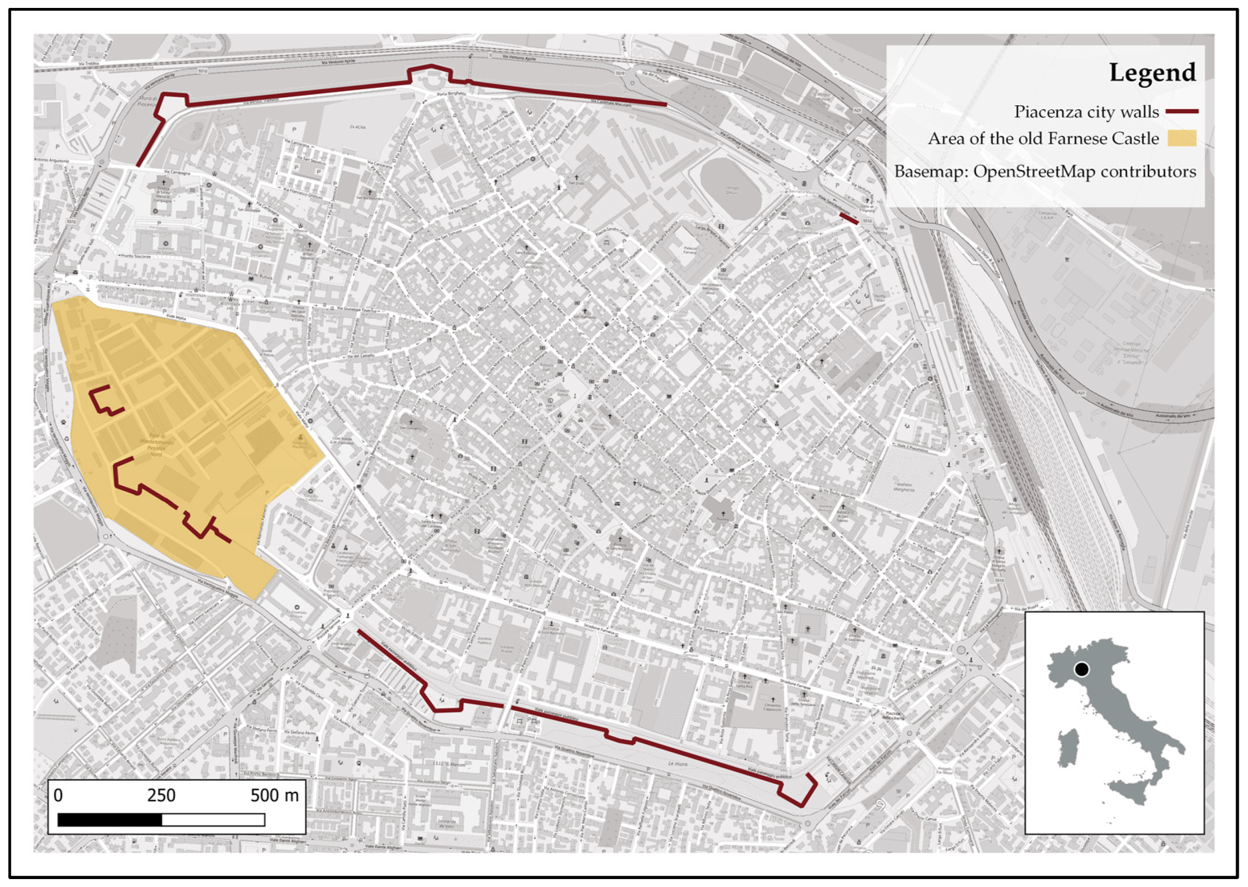
2. Historical and Cultural Context
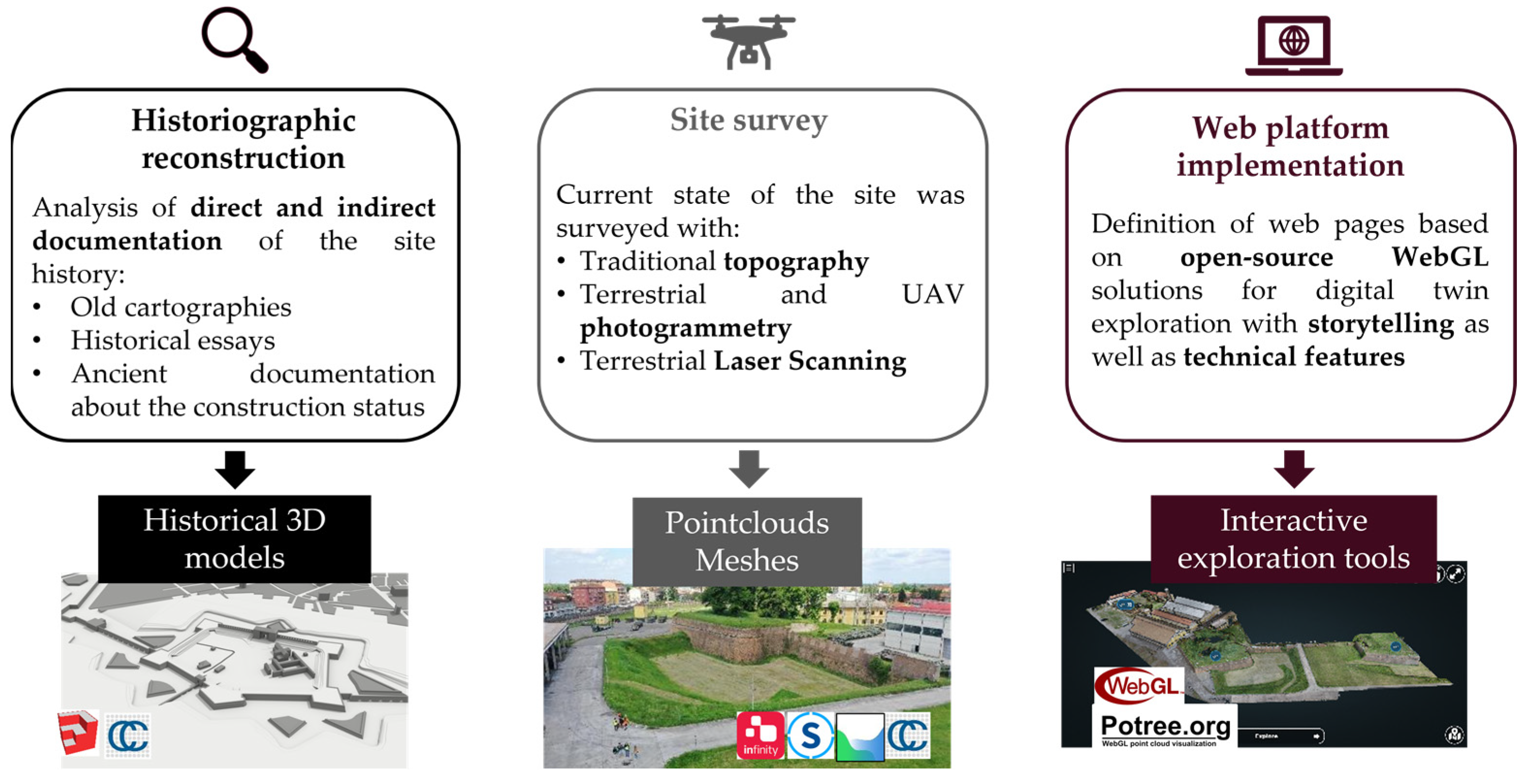
In recent decades, the rediscovery of Piacenza’s military and architectural heritage has provided insights into the city’s history. Research has focused on the Farnese Castle, also called Farnesian Citadel, which is part of the wider context of the city walls and has led to a greater awareness of the historical architectural heritage, which is little known to the citizens. In fact, the remains of the ancient pentagonal site, dating back to the XVI century, are located in the western part of the city, within the boundaries of the Polo di Mantenimento Pesante Nord of the Italian Army, a military area where access is restricted to authorised persons or to special occasions. Figure 1 shows the location of the study area and highlights the position of the parts of Piacenza’s walls that still exist today. As can be seen from the map, only three of the original five bastions remain, together with a curtain wall connecting two of them.
The construction and evolution of the structure of the Farnese Castle requires an in-depth study of how the defensive system of a Renaissance city was generally conceived and analysed during the XVI century. In this period, the urban landscape changed to adapt to the political and military situation. The invention of firearms was one of the many innovations that marked the transition from the Middle Ages to the Modern Age. The medieval walls were designed in the XII century and consisted of straight sections of wall, known as curtain walls, with a parapet and battlemented parapet at the top. The curtains were also interspersed with several towers and defended by other fortifications. Until the XV century, the strength of the fortifications was linked to their height and to the type of active defence known as “piombante”, which consisted mainly of throwing boiling liquids and objects from the top [46]. The introduction of mobile artillery cast doubt on traditional fortifications, raising questions about their effectiveness and stability. For this reason, a new type of fortification was considered, called “alla moderna”, with lower bastions and reinforced internally by an embankment [47]. During this period, many cities underwent transformations of their defensive structures, and Piacenza was no exception. From its foundation as a Roman city until the second half of the 19th century, Piacenza maintained the characteristics of a military outpost, preserving the architecture of the city walls in accordance with the ballistic theories and military strategies typical of each historical period, with the aim of defending the city.
Based on available documentation, the process of evolution of the defensive elements of the city of Piacenza that mark the history of the Farnese Castle can be schematised in 6 phases shown in Figure 2.
The Farnese city walls of the Renaissance period were commissioned in 1525 by Pope Clement VII de’ Medici upon taking possession of the city. This event marks Phase I of the timeline of the Castle’s evolution, during which the construction of the new Renaissance city walls was necessary to strengthen the defence system because of the ongoing military conflicts in North Italy [48]. In this period, Piacenza was constantly fought over by Pope Clement VII and Emperor Charles V and threatened by the advancing lansquenets. The city was also subjected to constant taxes for the reconstruction of the walls, and in 1528, it was hit by a severe famine and plague, which caused deep discontent [49]. Alessandro Farnese—elected pope in 1534 under the name Pope Paul III—played a crucial role in Piacenza’s history and, specifically, in the design of the citadel, completing the construction of the Renaissance wall in 1545.
On 17 August 1545, Emperor Charles V authorized Pope Paul III’s acquisition of the Duchies of Parma and Piacenza, which led to the constitution of the Duchy of Parma and Piacenza in favour of Pier Luigi Farnese, Alessandro’s son. Pier Luigi realised that the pre-existing defensive infrastructure, dating back to the XIV century, was no longer militarily secure and on 14 May 1547, began construction of a new fortress called the Farnese Castle [50], defined as Phase II in Figure 2. The fortress was designed during this period of innovation, when the urban and military spheres were intertwined. It was a small representation of the concept of a Renaissance fortified city. It was situated in the urban defences of the bastion walls, and it was conceived as an instrument of military and political domination over the territory. From a formal point of view, the pentagonal system was preferred to the quadrilateral system used in the previous centuries [51]. The idea was that the presence of more sides and more ramparts was a guarantee of greater protection. The castle was built west of Piacenza, occupying a large area that included the bastion of San Benedetto, which was already part of the city walls, and the monastery of San Benedetto, which was built on an ancient monastery of the Canons Regular Lateran of Saint Augustine [52]. The construction was based on a pentagonal design plan consisting of four bastions, built in the autumn of 1547, five curtains, and many bulwarks, which replaced the traditional towers (Figure 3) [52,53]. Two names have been proposed as architects: Antonio da Sangallo and his pupil Gian Battista Calvi. Antonio da Sangallo collaborated closely with Pier Luigi Farnese on projects, including the Palazzo Farnese in Rome, the establishment of Castro, and various fortifications in northern Lazio. Also, Sangallo’s familiarity with Piacenza’s architectural style suggests that the Piacenza citadel may be attributed to his craftsmanship. This is further substantiated by the striking resemblance to other citadels he designed, such as the Fortezza da Basso in Florence [54], the Rocca Paolina in Perugia, and the Cittadella in Ancona. Additionally, the Uffizi Museum houses numerous graphic references to Sangallo’s renderings, some of which depict a half bulwark with a double gunboat akin to the configuration of the Orecchione in Farnese Castle [50]. Following the original design plan, from May to September 1547, the Castle perimeter was traced around the pre-existing elements and connected to the city walls through the San Benedetto bastion.
Construction stopped in September of the same year after the assassination of Duke Pier Luigi, the victim of a conspiracy. Hence, the governor of Milan, Ferrante Gonzaga, in agreement with the conspirators, occupied the city as a dependency of the Duchy of Milan and Emperor Charles V. In Phase III of the Castle’s timeline, he resumed and completed the construction work that led to the development of the original curtain walls that extended for about 1350 m. At the end of 1553, the Castle was finally surrounded by a moat and provided with a main entrance from the city side. Also, the casemates and buttresses of the ramparts and their embankment were completed. Until the unification of Italy in the XIX century, the Castle was then under foreign occupation and governors were no longer interested in further structural developments [52].
In the early 19th century, the Castle was taken over by French troops. Subsequently, when Napoleon arrived in Piacenza in July 1805, the historic monastic church of San Benedetto was destroyed, following an explosion caused by the storage of weapons and military artillery powder in the castle (Phase IV).
Starting in 1848, due to the new urban expansion needs of the city, new portions of the castle were destroyed, in particular the ramparts and the curtain wall towards the city (Phase V). Following the unification of Italy, the Farnesian Citadel became the seat of the Military Arsenal and Artillery Directorate, which concealed the remains of the Castle that was partially demolished in 1848. As a result, the military administration did not consider any investigation of the rest of the Castle to be significant or of interest [52].
At the beginning of the twentieth century, other parts of the ancient Castle were demolished due to the allocation of new buildings for the Military Arsenal (Phase VI). It was only in recent decades that the commanders who took charge of the military establishments in Piacenza at the end of the 20th century began the process of rediscovering and excavating the three bastions that had been saved from destruction: San Benedetto, San Giovanni, and San Giacomo.

3. Methodology

This paper presents a method to digitally document the current state and the construction history of a cultural heritage site with limited accessibility, developing a web interactive platform for 3D exploration. The workflow consists of the following phases (Figure 4):
  • Historiographic reconstruction
  • Site survey
  • Web platform implementation

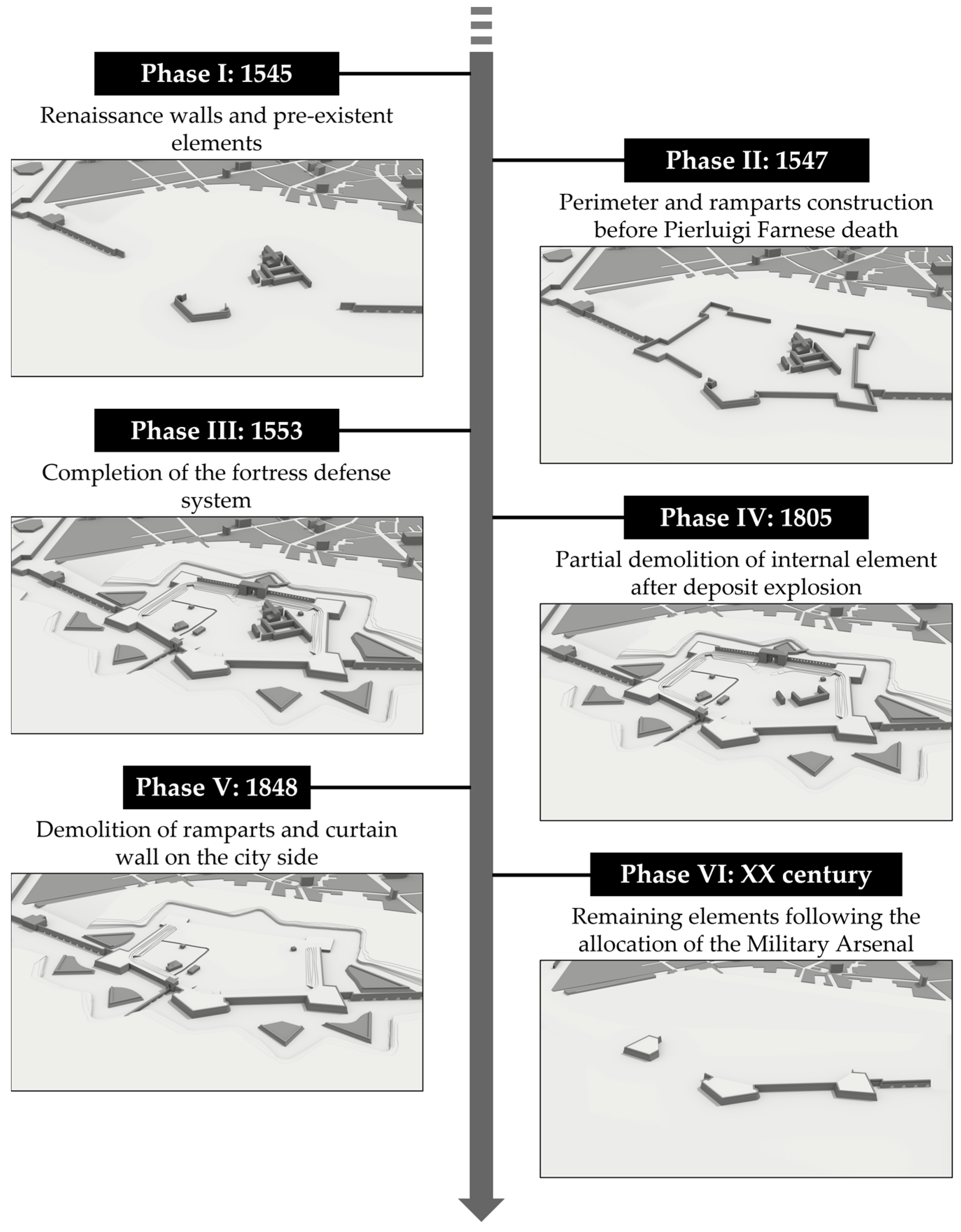
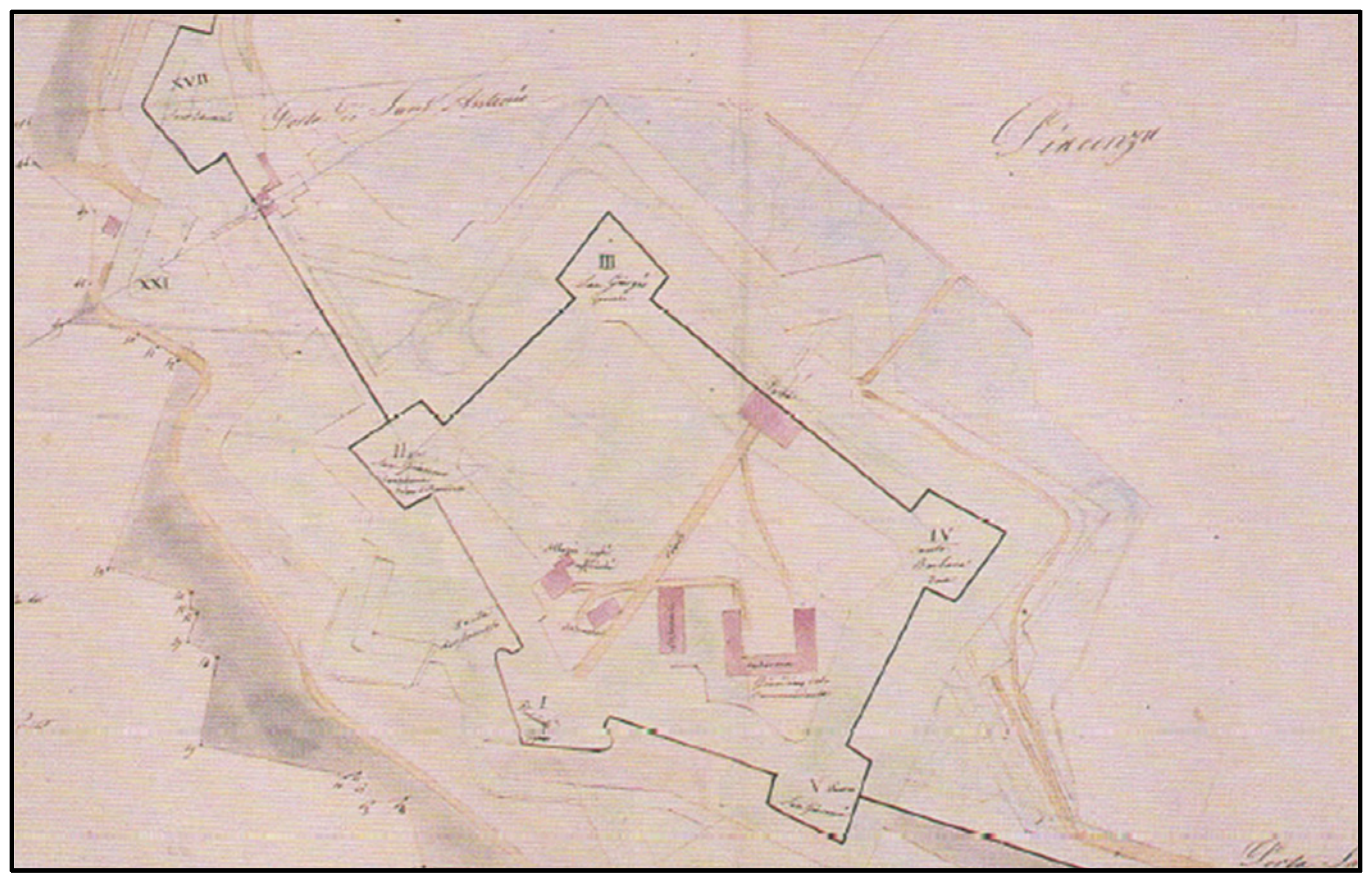
3.1. Historiographic Reconstruction
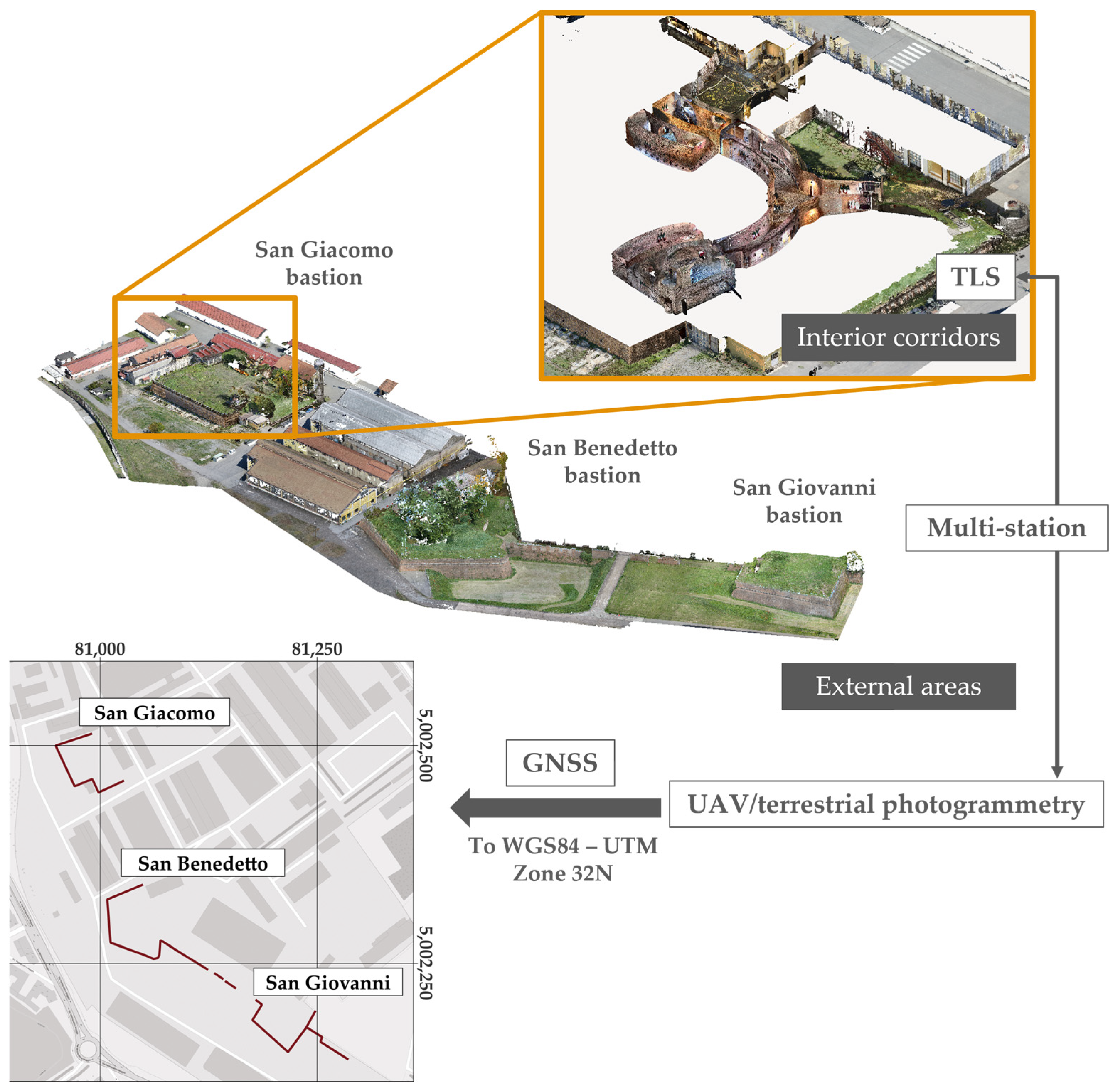
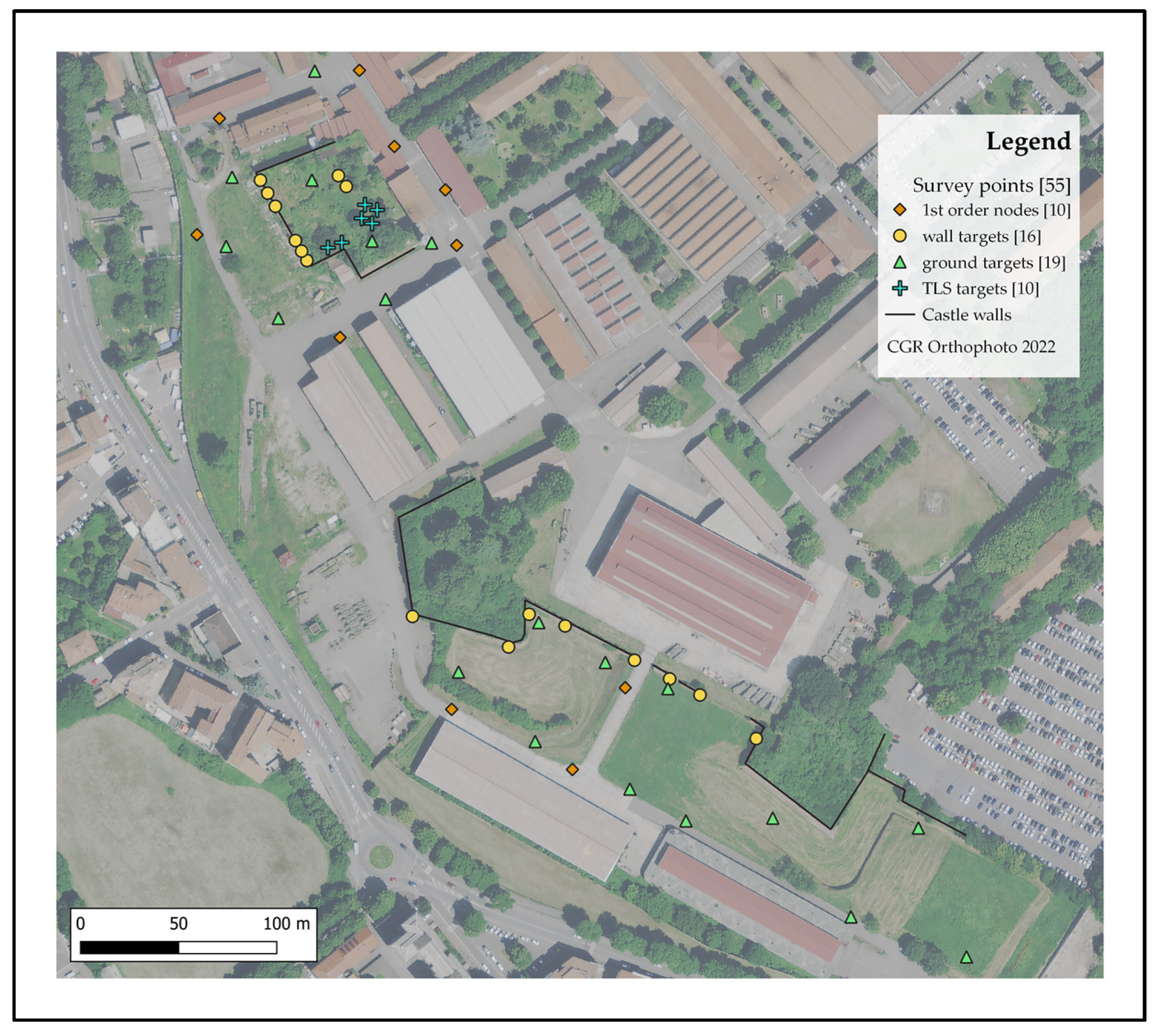
The preliminary step of the workflow aims to reconstruct the main phases of the history and construction of the CH site, as described in chapter 2. The analysis and interpretation of the historic documentation, as well as the ancient maps from the various sources mentioned in the previous paragraph, served not only to understand the cultural context of the site but also led to a 3D reconstruction of the various stages leading up to the completion of its construction. Starting from the available historical documentation, 3D models representing the main construction steps of the site were created with the combined adoption of AutoCAD and SketchUp for modelling and first rendering, documenting the construction evolution from 1547 to 1553 as well as the partial demolition of the site starting from the XIX century. At a later stage of the workflow, such products, initially framed in a local system, were georeferenced with a roto-translation in the CloudCompare environment [55] through comparison with the built structure documented in the current state of the site with the survey.

3.2. Site Survey

The current state of the Farnese Castle was reconstructed by integrating different surveying approaches, including UAV and terrestrial photogrammetry and TLS for 3D reconstruction, traditional topography and GNSS for defining a common reference system and georeferencing the different datasets [56]. The procedure carried out for the Farnese Castle 3D survey is illustrated in Figure 5.
For reconstructing the exterior area of the three bastions San Giovanni, San Benedetto and San Giacomo, two UAV photogrammetric surveys were conducted with off-the-shelf quad-copters DJI Phantom 4 RTK and Mavic 2 Pro. Phantom was used for the nadiral flight to cover the entire area, while Mavic 2 was used for the oblique acquisition of pictures closer to the structure. A total of 780 images, including 570 nadiral and 210 oblique images, were acquired to cover an area of ~59 000 m2. In addition to the UAV images, 240 images were acquired by a compact hand-held Nikon Coolpix S3500 camera to gain a closer view of the lower parts of the bastions’ walls. To georeference the photogrammetric block, a set of 35 targets was deployed over the site both on the ground and on the walls, to properly constrain both the nadiral and oblique images. The location of the targets was measured in a local reference system by a multistation Leica MS60 [57]. The multistation was used to build a closed polygonal network covering the whole study site, from which all the targets were measured. Among the 35 targets, 24 of them were used as Ground Control Points (GCPs), while the remaining 9 were used as Check Points (CP) to evaluate the accuracy of the photogrammetric block (Figure 6). The full photogrammetric block was processed with Agisoft Metashape to derive a dense point cloud of the exterior areas of the Farnese Castle. For images taken with the DJI Phantom 4 RTK, the perspective center coordinates were used to better constrain the location of the cameras within the bundle block adjustment step in Metashape.
The interior corridors of the San Giacomo Bastion were reconstructed by 14 TLS scans acquired with a Faro Focus M70. All the scans were coregistered by the Iterative Closest Point (ICP) algorithm on overlapping areas [58] using the scanner proprietary software Faro Scene. To link together the photogrammetric block of the external areas and the TLS scans of the interior corridors, 2 additional targets were strategically positioned on the corridor walls. These targets were placed to ensure visibility from the exterior through the corridor’s windows and loopholes and were measured by the multistation within the same local reference system employed for the photogrammetric block. Additionally, three out of the 14 scans were specifically acquired to provide overlaps with the UAV-point clouds of the outer backyard of the San Giacomo bastion.
All the point clouds were roto-translated from the local reference system to the official Italian reference system WGS84/UTM Zone 32N by measuring six on-ground targets both with the multistation and with a topographic-grade GNSS receiver Leica GS14, employed in nRTK mode.
Finally, the coregistered point clouds were merged and subsampled to have a homogenous point spacing of ~2 cm. The resulting point cloud was further manually cleaned by using CloudCompare to remove spurious or unnecessary points.

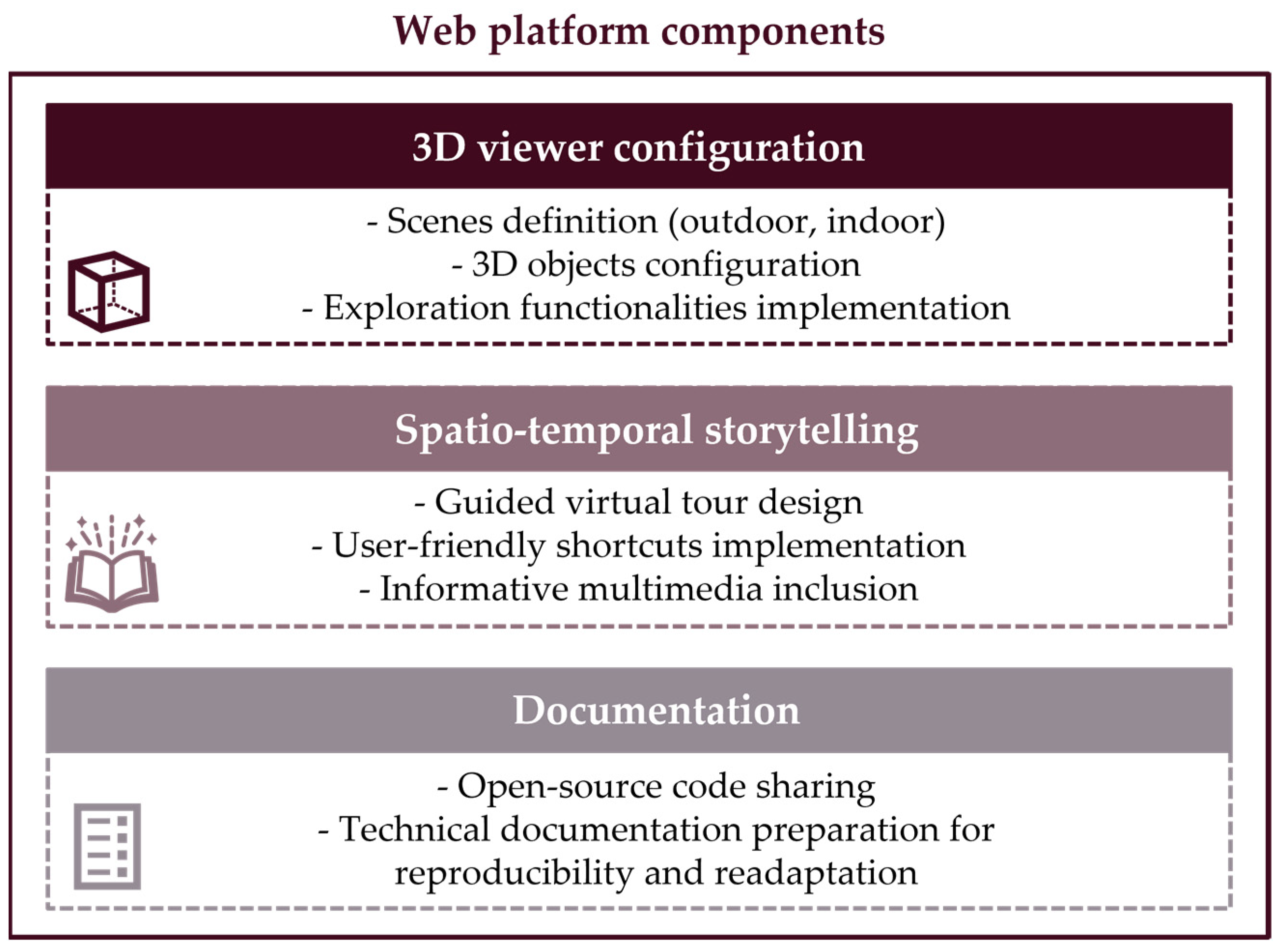
3.3. Web Platform Implementation

The third step of the methodology consists of the implementation of a user-friendly web platform based on open-source technologies for virtual exploration and dissemination of the CH site. In particular, the developed prototype is based on 3 different components (Figure 7) in order to create an accessible virtual interactive experience for both technicians familiar with geomatics products as well as simple users interested in the history of the CH site.

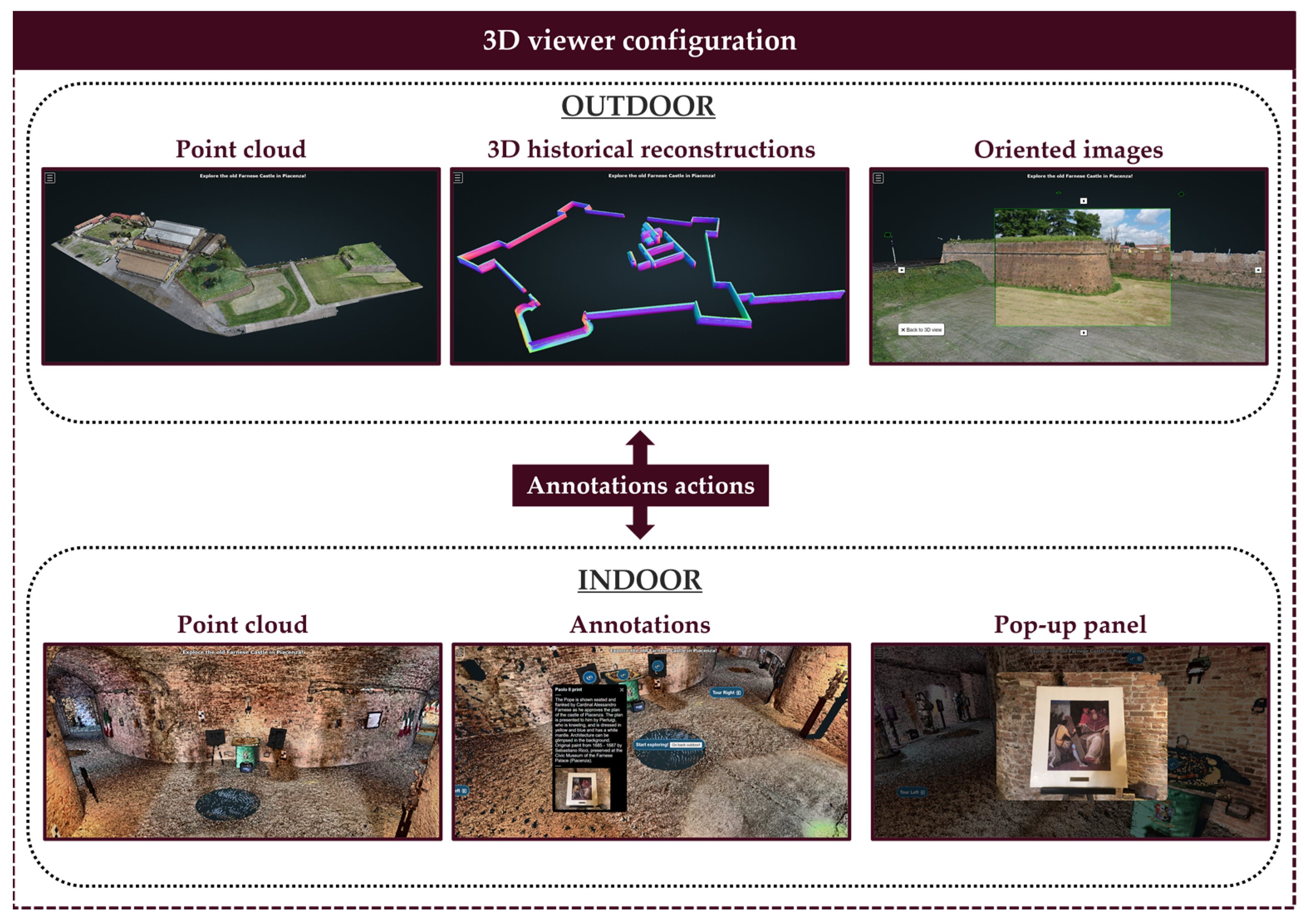
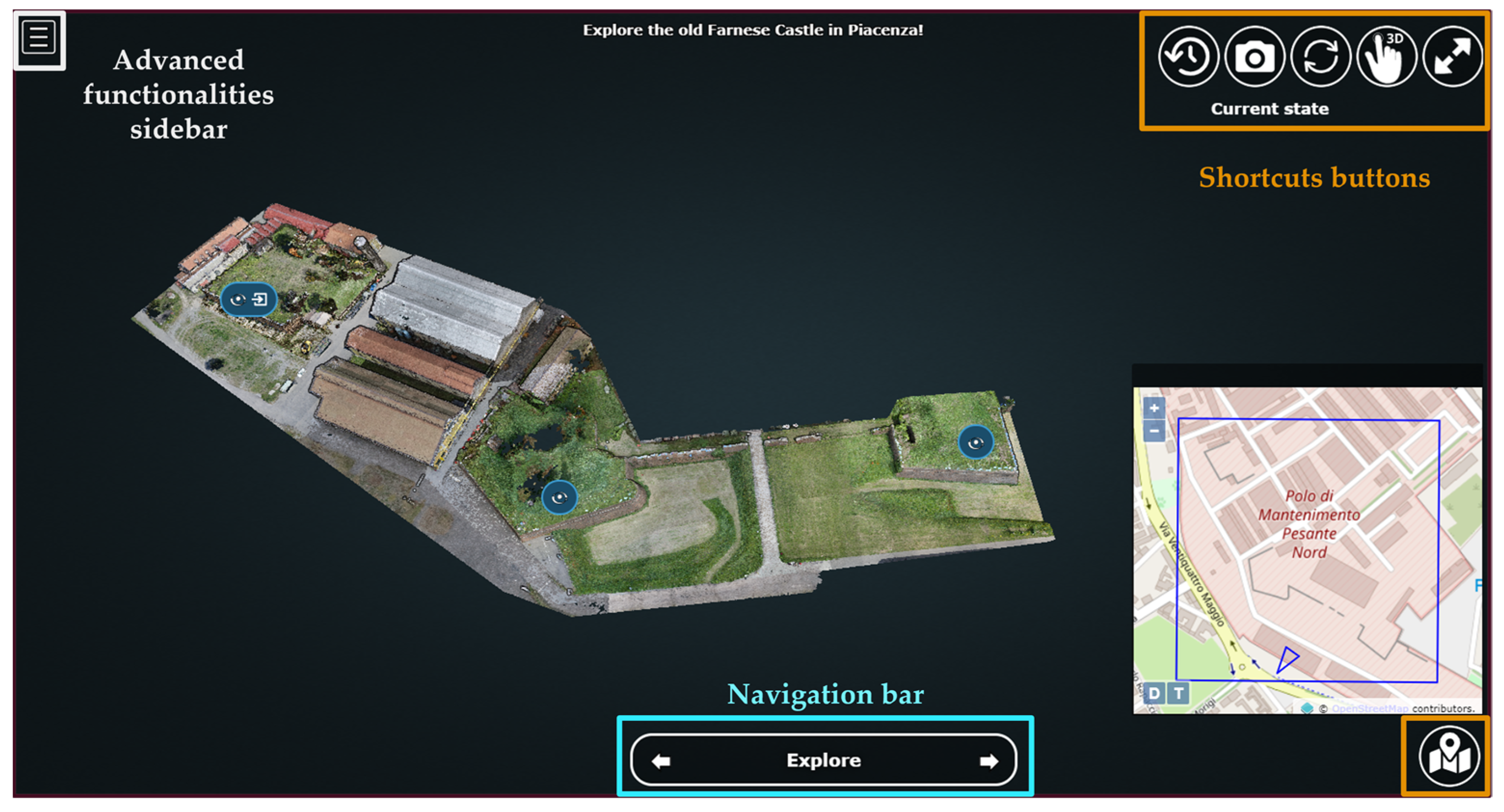
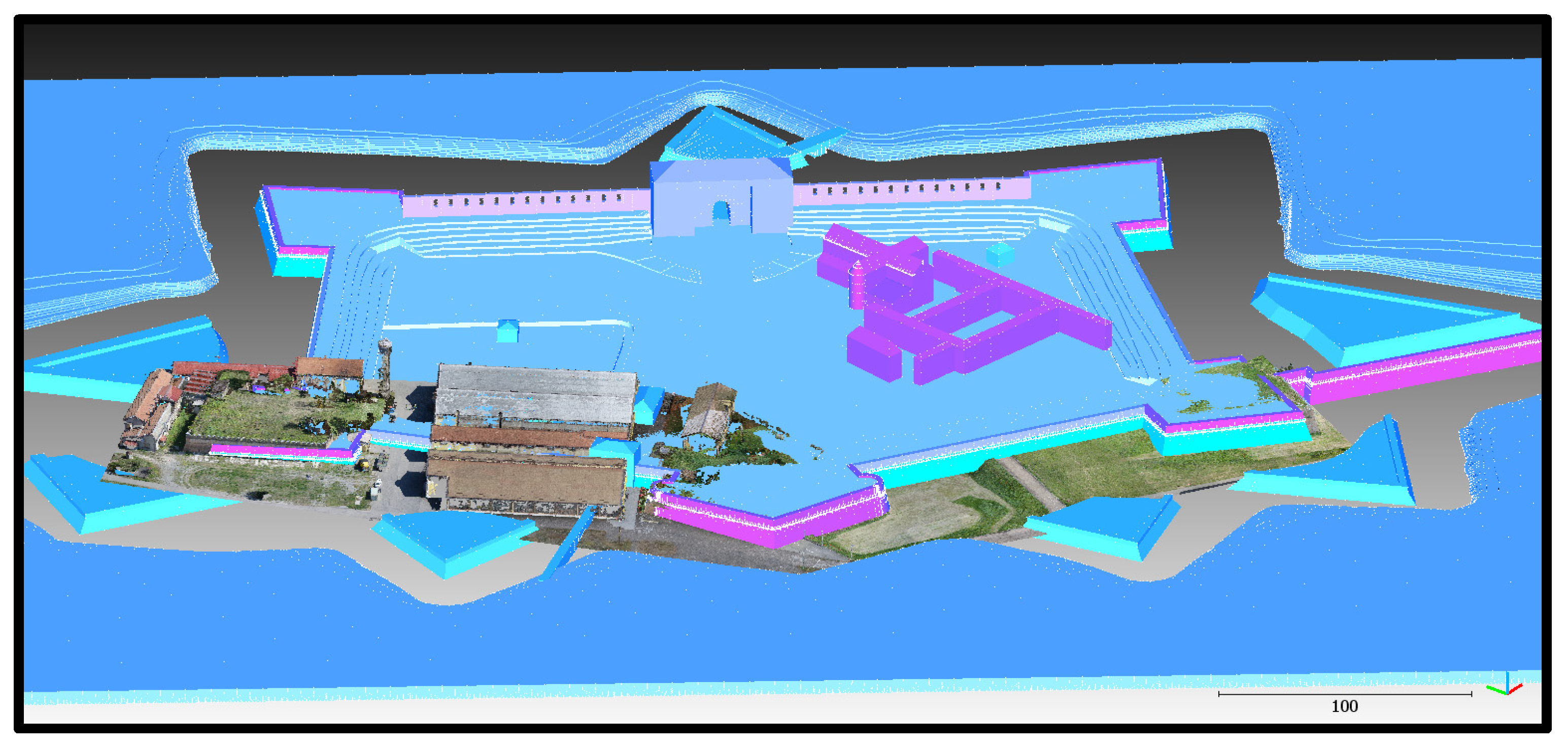
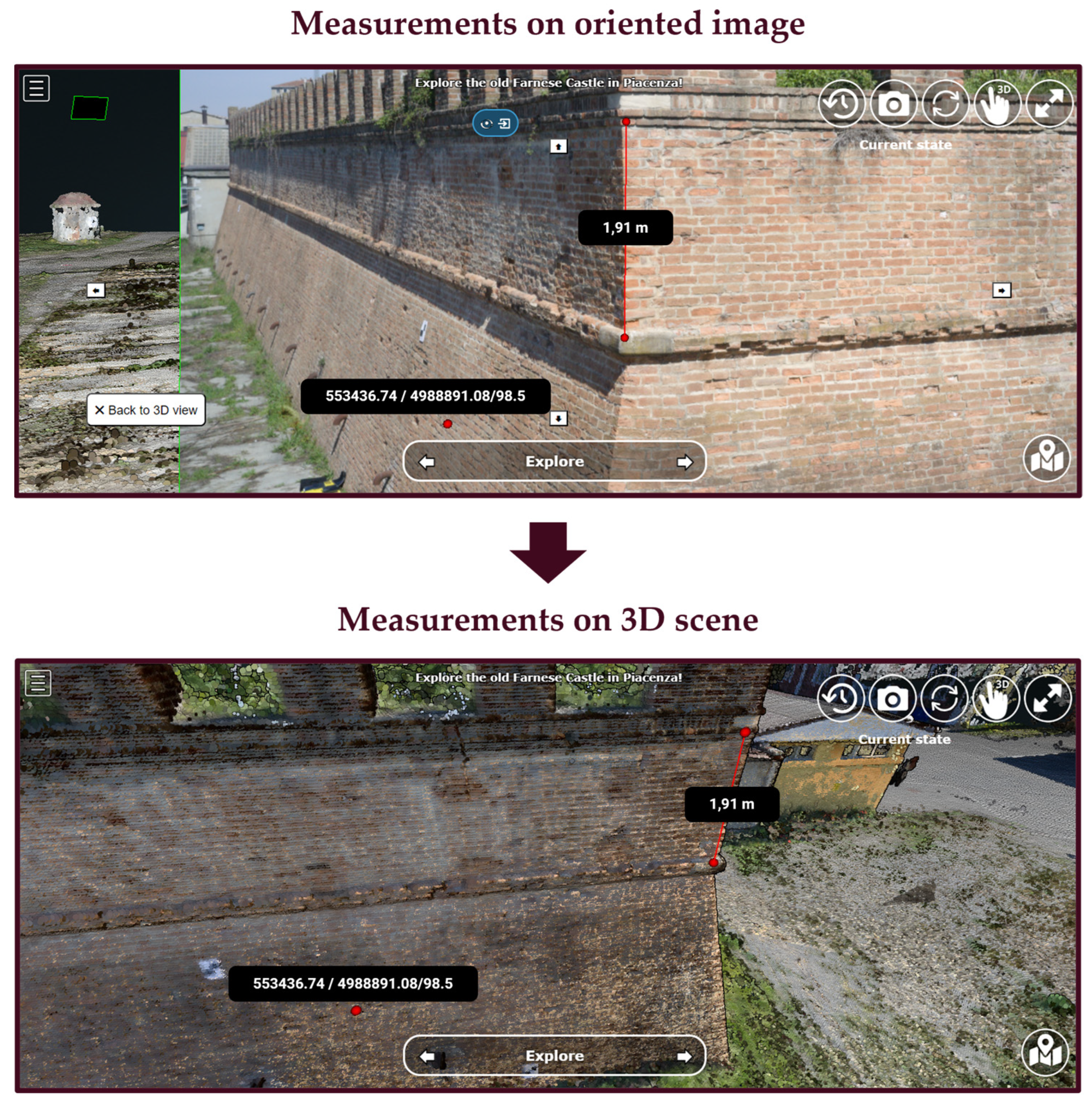
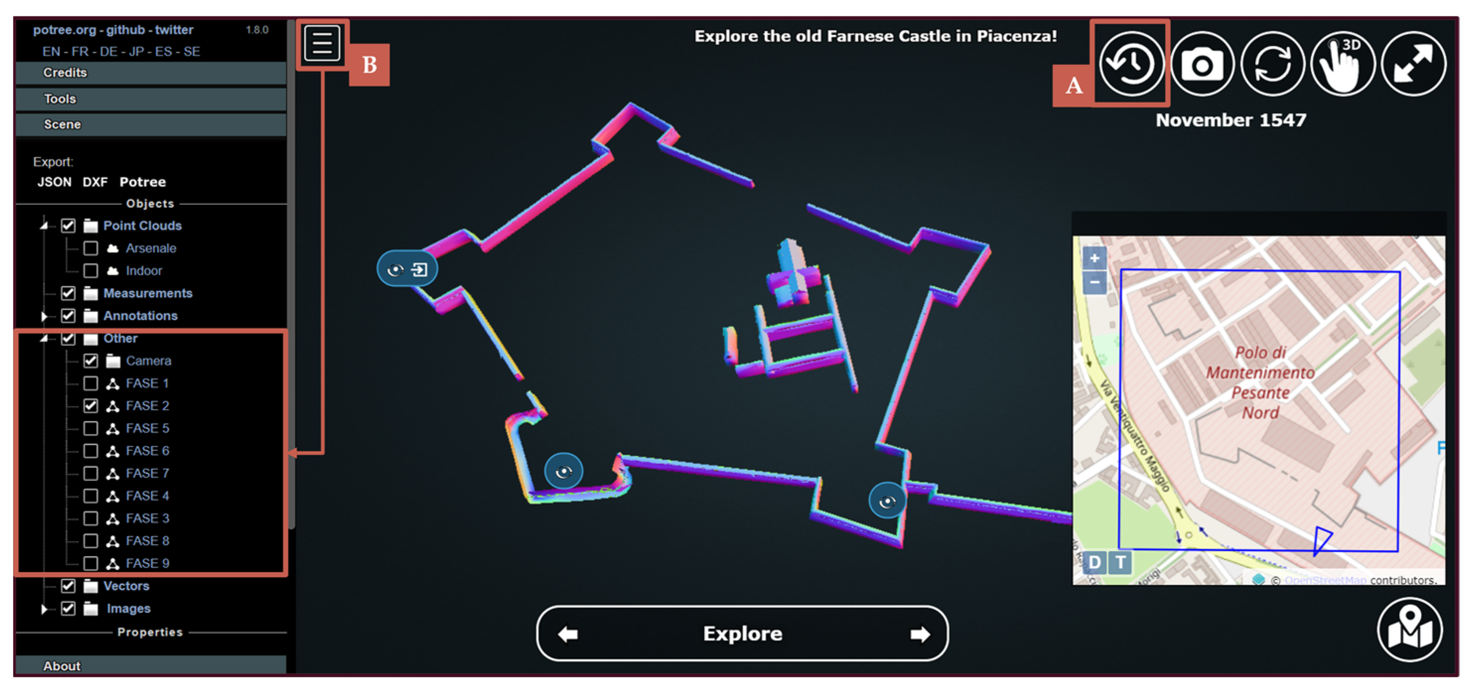
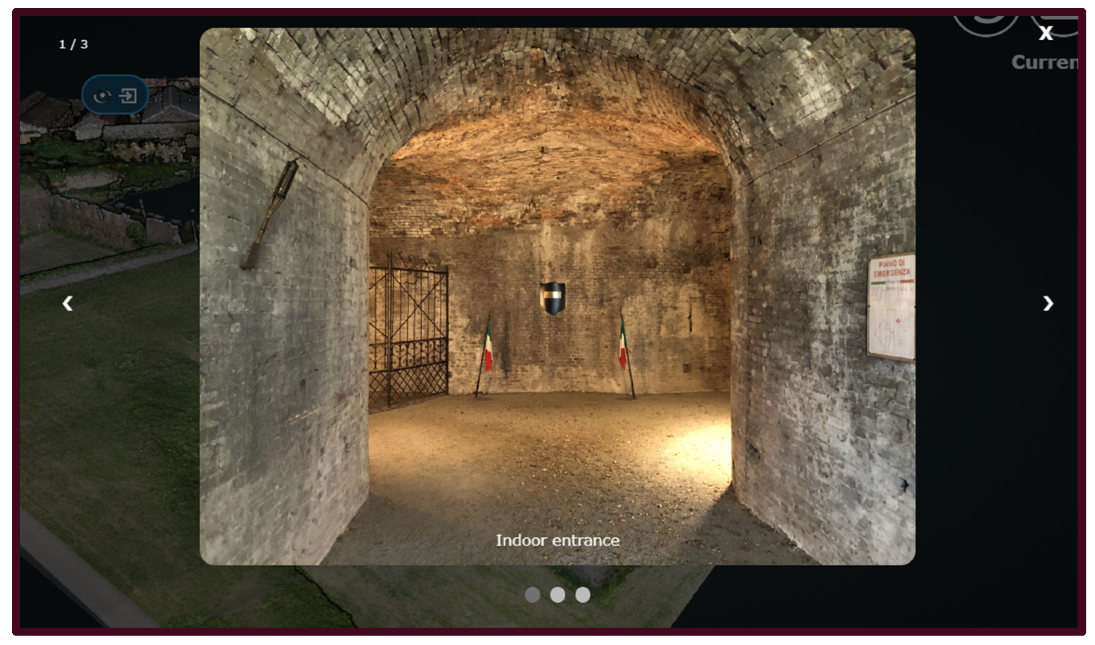
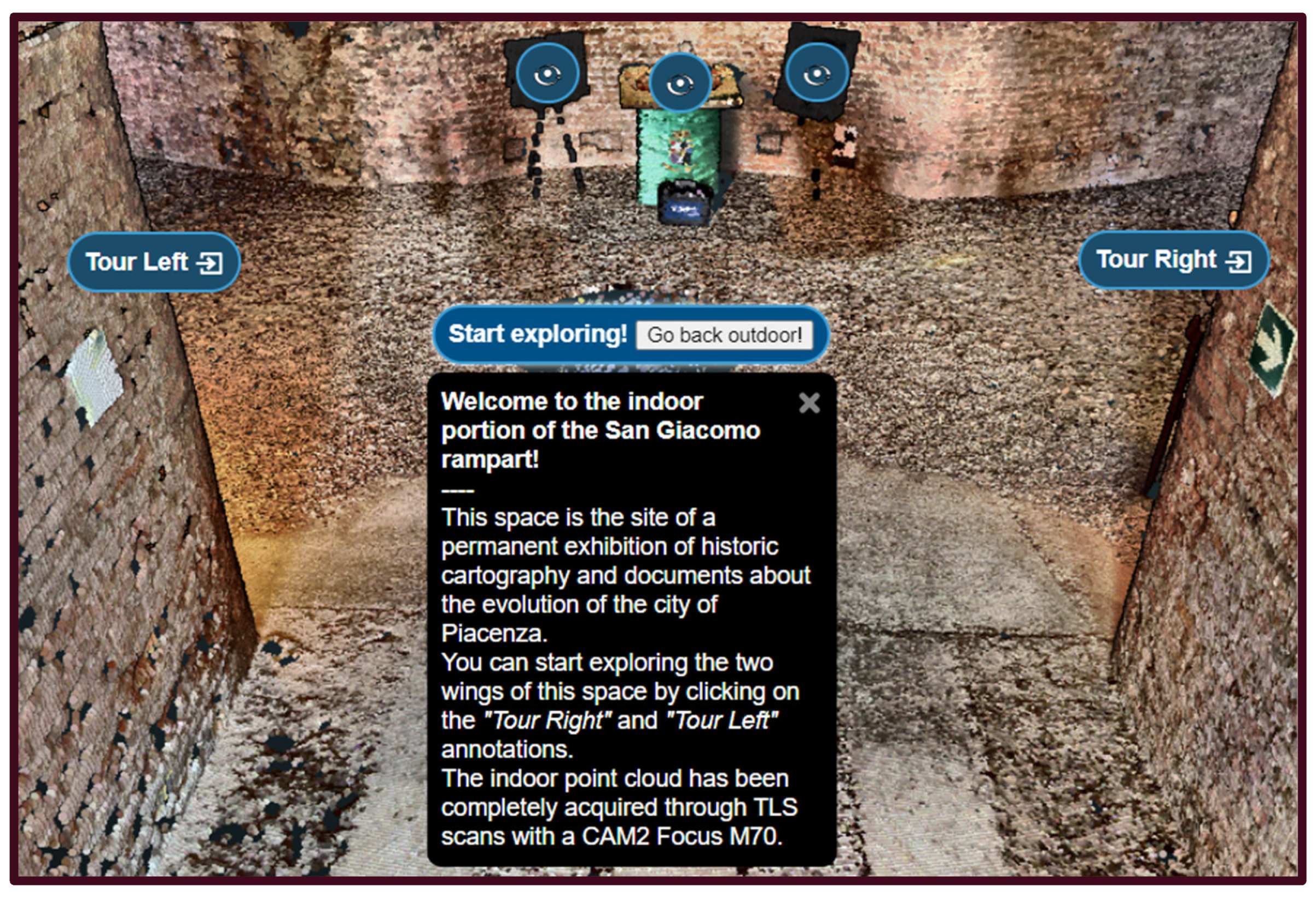
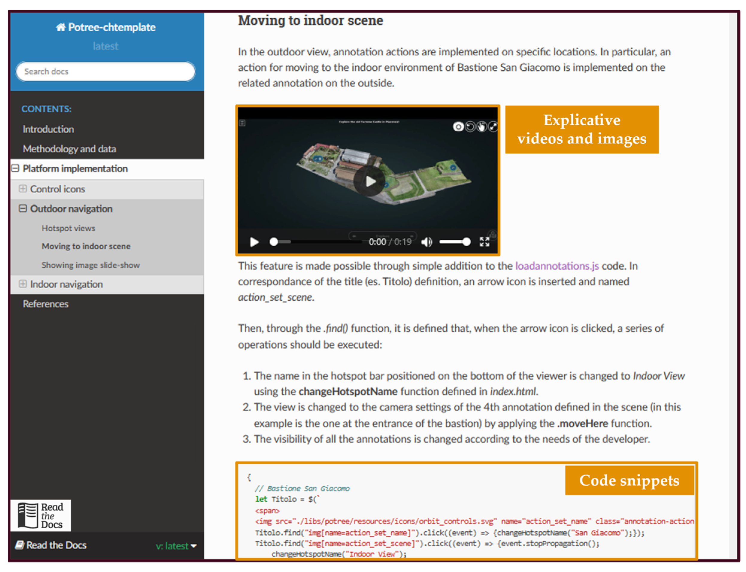
3.3.1. D Viewer Configuration

The first essential step in implementing the web platform is to configure a lightweight web space that enables 3D object exploration. The tool adopted for this purpose is Potree, an open-source WebGL-based viewer optimized for point clouds rendering on the web [38]. Such a library written in JavaScript (JS) language is built on top of existing packages for handling 2D and 3D objects and navigation, cartographic projections, as well as user interactions (e.g., three, proj4, openlayers, tween). In addition to point clouds, Potree also supports the visualization of meshes, shapefiles and geopackages, making the integration of files and information in different formats possible in a single 3D space.
The configuration starts with the conversion of the georeferenced point cloud resulting from the in situ survey in a Potree-supported format through the dedicated PotreeConverter tool. Hence, a basic Hyper Text Markup Language (HTML) index page is configured in order to include in the web page the Potree render area for the visualization of 3D objects, as well as its sidebar that contains native tools for making measurements, extracting cross-section and volumes from a point cloud. In this environment, the point cloud is added to the main scene in the render area, already enabling the native functionalities of the viewer, such as pan, zoom and rotation.
In order to include other georeferenced multimedia and informative objects in the viewer, two distinct scenes are then defined (Figure 8): the outdoor one to exploit the visualization potential at the entire CH site scale, and the indoor one for the exploration of the more detailed environment inside the surveyed castle rampart. This choice is motivated by the need to subsequently define specific storytelling strategies at different scales, as well as to ensure optimized computation and rendering of 3D objects by efficiently regulating their visibility on the screen.
Different types of objects are included in the two scenes. In particular, in the outdoor scene the point cloud of the current state of the site—the remaining visible three ramparts—is loaded alongside the 3D historic reconstruction models of the entire castle. Also, the same scene includes oriented images, e.g., photos taken by drones or ground cameras and used for the 3D reconstruction process, obtaining their orientation parameters (projection centre, camera position and angles at the time of each shot). The result of such an operation is the ability to click on a given oriented image positioned in the outdoor scene and evaluate it in detail in a 2D view, also making measurements on it that are coherently projected onto the 3D point cloud.
The indoor scene contains a point cloud representing the 3D interior environment of the inspected rampart. Such a georeferenced product serves as the starting point for inserting annotations in the scene to support user navigation. By clicking on them, users can start the exploration with guided camera views of objects or artefacts of interest in the indoor environment. Moreover, each annotation is associated with a descriptive multimedia panel that contains additional information on the historical or cultural context of the linked element. Alternatively, a dedicated fixed pop-up appearing on the scene can be associated with chosen annotations, highlighting particular elements.
Finally, the spatial interaction between the indoor and the outdoor scenes is managed by inserting special annotations with actions, i.e., icons that, when clicked, activate a camera transition from the outdoor to the indoor environment or vice versa. Depending on the scene that is the target of the actions, the visibility of specific objects and entities on the viewer is then automatically changed.

3.3.2. Spatiotemporal Storytelling

The simple setup of the Potree environment with both the viewer and the sidebar provides essential exploration tools for those who are already familiar with the library. However, the nontechnical audience still lacks user-friendly shortcuts and facilities that make the point cloud format more understandable or allow easy interaction with each scene. For this purpose, the basic Potree interface has been updated with custom Graphic User Interface (GUI) features, like buttons, sliders, dropdown menus, and interactive texts (Figure 9).
In particular, six main buttons are included in the main GUI, providing the users with easy access to interactive functionalities. Some of them allow users to enter full-screen mode, make the navigation instructions panel visible or reload the page. Other custom buttons make it possible to show a small OpenStreetMap map highlighting the position of the bounding box of the loaded scene and to change the visibility of the oriented images in the outdoor scene. A special storytelling function is provided by the “rewind” button, which, through successive clicks, changes the visibility of the 3D objects—either point clouds or meshes—showing the evolution of the Farnese Castle complex from 1547 to the present day. To make it easier to understand this functionality, each click is associated with the appearance of a dynamic text on the right-hand side of the screen with the name of the historical phase represented by the model being displayed.
Then, in order to facilitate the spatial exploration of the CH site, a navigation bar is configured to allow navigation through predefined hotspots of interest by clicking left and right arrows. Additionally, a dropdown menu accessible by clicking on the navigation bar is available, making it possible to switch the camera view to the desired hotspot on the scene.
Indoor space exploration is designed along pre-fixed paths, as in real-world cultural or art exhibitions. Custom annotations are inserted at the entrance of the two wings of the indoor rampart. They include annotations that, if clicked, trigger a camera animation, launching a virtual tour of both interior corridors and activating along the path the visibility of annotations linked to artworks and exhibition features. Such animations are implemented through the interpolation of a set of triplets of coordinate values of camera positions as well as their orientation parameters.

3.3.3. Open Documentation and Reproducibility

In addition to the implementation of the web platform, technical documentation of the entire procedure adopted for the case study was prepared to promote the future adoption of the proposed FOSS architecture for other cultural heritage sites. This included detailed instructions on how to define 3D scenes and place objects within them, as well as tutorials on how to incorporate specific GUI commands, shortcuts, and exploration features. This information was formatted into reStructuredText (.rst) files using the Python Sphynx library, and then posted on a dedicated webspace instance of ReadTheDocs, an open-source technical documentation hosting platform. Additionally, the code (HTML, CSS and JS language) for the 3D web viewer application has been openly made available online in a dedicated open-source GitHub repository. This way, future researchers or developers interested in the project could modify and adapt the code structure to other case studies and applications, fostering collaboration and reproducibility.

4. Results and Discussion

4.1. Historiographic Reconstruction

The 3D digital reconstruction of the construction phases resulted in a series of nine meshes representing the evolution of the Castle according to the original plans and maps of Piacenza. This series of 3D objects included both the states of the site corresponding to the main historical phases depicted in Figure 2 as well as additional models with intermediate structural changes reported in the literature and old maps. The originally designed proportions of the bastions and curtain walls were maintained due to the lack of quantitative information on changes during construction. The models were georeferenced into the WGS84/UTM Zone 32N reference system by manually collimating peculiar features (e.g., bastion corners) visually recognizable both in the historical and in the UAV point cloud (Figure 10).

4.2. Site Survey

The external areas of the three bastions, San Giacomo, San Giovanni, and San Benedetto, were reconstructed by integrating UAV and terrestrial images into a cohesive photogrammetric block, processed using Agisoft Metashape. The accuracy of the photogrammetric block was evaluated based on nine CPs not used in the bundle adjustment, yielding an RMSE of 3.5 cm (Table 1). The resulting photogrammetric point cloud comprised 85 million points.
The TLS survey consisted of 14 scans of the San Giacomo Bastion interior corridors and a portion of the outer wall. The resulting point cloud, encompassing approximately 145 million points, included RGB colours derived from the TLS camera and laser return intensity for each point. The coregistration of TLS scans, based on the ICP algorithm and aided by four targets measured with subcentimetric accuracy with the multistation MS60, resulted in an RMSE of 1.2 cm in overlapping areas.
The coherence between the photogrammetric and TLS point clouds was evaluated in an overlapping portion of the outer San Giacomo Bastion wall by a cloud-to-cloud comparison using CloudCompare. This analysis yielded an RMS of distances between the point clouds of 1.8 cm, which is comparable to the accuracy of the photogrammetric models and the TLS registration error. The final unified and subsampled point cloud of Farnese Castle comprised 32 million points, with an average point spacing of 2 cm and centimetric accuracy.

4.3. Web Platform Implementation

The implemented 3D web viewer, currently hosted on the authors’ laboratory server, serves as the main platform where users can retrieve both historical and metrical information. It provides simplified access to accurate 3D georeferenced data and makes it possible to explore it with simple mouse clicks. In particular, it supports the navigation and multi-level evaluation of the CH site. By integrating different formats of 3D data, it allows the exploration of their functionalities for different types of audiences. For example, oriented images of the outdoor scene help users unfamiliar with 3D products, such as point clouds, to navigate through the current state of the site. At the same time, they provide a georeferenced visual record of the condition of the site at the time of the survey, giving experts in the field valuable insight into the structural health assessment of the castle. Experts can easily identify defects or damages with a virtual visual inspection and then annotate them—extracting their coordinates—and measure their extension on the structure, obtaining quantitative observations on their level of severity. Such operations are made possible by the fact that the orientation parameters associated with the images allow a clicked point on the 2D object (single picture) to be automatically associated with a specific triplet of coordinates in the 3D scene in which the point cloud is located (Figure 11).
Additionally, the platform gives users the choice of freely exploring the 3D scene or following predefined virtual tour routes. This flexible approach is, again, particularly useful for providing custom experiences suitable to a wide variety of users with different backgrounds and interests. From the historical storytelling point of view, for instance, new users can gradually evaluate the progress in the construction of the CH site by simply clicking a dedicated button in sequence. However, more familiar users of similar Potree-based platforms can directly access a specific historical reconstruction from the lateral sidebar, activating the visibility of the desired 3D object on the structure tree of the scene (Figure 12). Similarly, users may decide to take advantage of the presence of the hotspot bar for navigating through the prefixed point of view or ignore it and directly jump to the desired point of interest inside the scene, using hidden annotations from the sidebar or exploring with laptop mouse controls. Ultimately, regardless of the exploration choices and modes chosen by the user, the public can interactively reconstruct the history of the CH site, raising awareness of how the Castle has changed drastically over time and what remains in the current state of the complex.
In addition, native Potree annotations provide a double functionality in support of a user-friendly and enjoyable 3D scene exploration. First, they enrich the storytelling of the site, giving users additional historical and cultural context with custom pop-ups containing images, texts, slideshows, and external links for in-depth studies of objects inside the scene (Figure 13). Second, annotations provide reliable anchor points for users who, if lost in free navigation of the scene, can click on one of them to return to pre-established virtual tours (Figure 14). The inclusion of actions to activate camera animations and toggle the visibility of objects in the scene also encourages users to explore the site more interactively, defining a treasure hunt-like experience to discover all the hidden elements in the Castle.
The template code, written in HTML, CSS and JavaScript, along with images and icon assets is available on a dedicated GitHub repository (https://github.com/labmgf-polimi/potree-chtemplate) (accessed on 20 January 2024).
The reproducibility of the implementation of the platform is guaranteed by its open digital documentation on ReadTheDocs, providing more detailed information on how the platform was designed and structured. Moreover, for each functionality, either Potree native or customised, readers could find guided tutorials on how to implement them with both supporting code snippets and multimedia content, like videos and screenshots (Figure 15).

5. Conclusions

In this work we illustrate a workflow to digitally document a CH site for its implementation in an easily replicable web 3D platform. Preliminary steps of the process required the execution of historiographical research and an in situ geomatics survey. Historical documents and ancient maps resulted in the reconstruction of the timeline of the construction of the site and its subsequent deconstruction. The field survey, instead, allows us to obtain a georeferenced point cloud of the current conditions of the structure through photogrammetry, terrestrial laser scanning and traditional topographic network measurements. The resulting georeferenced product is then inserted into a web environment that allows the customisation of a 3D scene in a dedicated exploration platform.
The 3D web platform presented in this paper identifies a common ground for digital documentation and storytelling, implementing simple visualisation and elaboration instruments with simplified and accessible exploration functionalities for CH dissemination and promotion to nonexpert audiences. The ability of a WebGL-enabled environment based on the JS library of Potree allows us to easily integrate different formats of 3D and 2D data in a single platform, giving users the possibility to interact with it in multiple ways depending on their needs, becoming familiar with the environment and the objects themselves. The inclusion of photogrammetry and TLS-derived products also supports a more realistic virtual experience on the web platform, providing a better understanding of the conditions of the surveyed site.
The design and the implementation of the platform are intended to be low-cost and easy to replicate. In fact, the choice of adopting free and open-source solutions for its development and the publication of the code and its documentation online provide other interested researchers or CH experts the ability to implement and customise their own version of the platform. The developed prototype leaves it to other developers to extend the basic functionality according to their own needs.
Future developments are, for example, the adoption of the proposed template in more complex platforms, capable of using the visualisation and interaction capabilities to support collaborative database compilation, so as to also keep a record of the observations and processing as well as the generation of new objects carried out during a work session. Also, evaluating the integration in the template of Heritage Building Information Modelling (HBIM) products could provide more insights and information on the evolution of the different structural components of the site in each historical phase. At the same time, such a framework could also support an even more engaging experience for a wider range of users, even those not familiar with geomatics products. For example, a database structure supports the gamification of the 3D exploration and storytelling, saving the achievements and interactions in treasure hunt-like virtual tours of the site with leaderboards.

Author Contributions

Conceptualization, F.G. and F.I.; Data curation, F.G., F.B. and F.I.; Investigation, F.G.; Methodology, F.G.; Project administration, L.P.; Software, F.G.; Supervision, L.P.; Validation, F.B. and F.I.; Visualization, F.G. and R.F.; Writing—original draft, F.G.; Writing—review and editing, F.G., R.F. and F.I. All authors have read and agreed to the published version of the manuscript.

Funding

This research received no external funding.

Data Availability Statement

The source-code of the platform is openly accessible in the GitHub repository: https://github.com/Tars4815/potree-chtemplate (accessed on 20 January 2024). The open documentation is available on the ReadTheDocs instance: https://potree-chtemplate.readthedocs.io/en/latest/ (accessed on 20 January 2024). A demo is online on the author’s laboratory website: https://labmgf.dica.polimi.it/pujob/potree-template/ (accessed on 20 January 2024). The actual point cloud of the heritage site is only available for web exploration and not for download, due to the restrictions of the Military Arsenal of Piacenza on third party use.

Acknowledgments

The authors thank Marcello Spigaroli and Ente Farnese for the stimulating and exciting study opportunity and for the support on the historical investigation on the site. Moreover, they would like to acknowledge the collaboration demonstrated by the Military Arsenal of Piacenza and the Historical Archives of Parma in facilitating the research in the archives and libraries. A special acknowledgement to Michele Dondi and Clara Rivieri that contributed to the historiographic research of the castle as well as to the survey of the site in the context of their Bachelor thesis project.

Conflicts of Interest

The authors declare no conflicts of interest.

References

  1. Guzmán, P.C.; Roders, A.P.; Colenbrander, B.J.F. Measuring links between cultural heritage management and sustainable urban development: An overview of global monitoring tools. Cities 2017, 60, 192–201. [Google Scholar] [CrossRef]
  2. Remondino, F.; Rizzi, A. Reality-based 3D documentation of natural and cultural heritage sites—Techniques, problems, and examples. Appl. Geomat. 2010, 2, 85–100. [Google Scholar] [CrossRef]
  3. Pepe, M.; Alfio, V.S.; Costantino, D. UAV platforms and the SfM-MVS approach in the 3D surveys and modelling: A review in the cultural heritage field. Appl. Sci. 2022, 12, 12886. [Google Scholar] [CrossRef]
  4. Hassan, A.T.; Fritsch, D. Integration of Laser Scanning and Photogrammetry in 3D/4D Cultural Heritage Preservation—A Review. Int. J. Appl. 2019, 9, 16. [Google Scholar]
  5. Gabellone, F. Development of an Immersive VR Experience Using Inte-grated Survey Technologies and Hybrid Scenarios. Heritage 2023, 6, 1169–1186. [Google Scholar] [CrossRef]
  6. Gagliolo, S.; Fagandini, R.; Federici, B.; Ferrando, I.; Passoni, D.; Pagliari, D.; Pinto, L.; Sguerso, D. Use of UAS for the conservation of historical buildings in case of emergencies. Int. Arch. Photogramm. Remote Sens. Spat. Inf. Sci. 2017, 42, 81–88. [Google Scholar] [CrossRef]
  7. Chiabrando, F.; Sammartano, G.; Spanò, A.; Spreafico, A. Hybrid 3D models: When geomatics innovations meet extensive built heritage complexes. ISPRS Int. J. Geo-Inf. 2019, 8, 124. [Google Scholar] [CrossRef]
  8. Tucci, G.; Bonora, V.; Conti, A.; Fiorini, L. Digital workflow for the acquisition and elaboration of 3D data in a monumental complex: The Fortress of Saint John the Baptist in Florence. Int. Arch. Photogramm. Remote Sens. Spat. Inf. Sci. 2017, 42, 679–686. [Google Scholar] [CrossRef]
  9. Di Stefano, F.; Chiappini, S.; Piccinini, F.; Pierdicca, R. Integration and Assessment Between 3D Data from Different Geomatics Techniques. Case Study: The Ancient City Walls of San Ginesio (Italy). In International Workshop on R3 in Geomatics: Research, Results and Review, 1st ed.; Springer International Publishing: Cham, Switzerland, 2019; pp. 186–197. [Google Scholar]
  10. Mirabella Roberti, G.; Nannei, V.M.; Azzola, P.; Cardaci, A. Preserving the Venetian fortress of Bergamo: Quick photogrammetric survey for conservation planning. Int. Arch. Photogramm. Remote Sens. Spat. Inf. Sci. 2019, 42, 873–879. [Google Scholar] [CrossRef]
  11. Tanduo, B.; Teppati Losè, L.; Chiabrando, F. Documentation of complex environments in cultural heritage sites. A SLAM-based survey in the Castello del Valentino basement. Int. Arch. Photogramm. Remote Sens. Spat. Inf. Sci. 2023, 48, 489–496. [Google Scholar] [CrossRef]
  12. Diara, F.; Roggero, M. The Frinco Castle: From an Integrated Survey to 3D Modelling and a Stratigraphic Analysis for Helping Knowledge and Reconstruction. Remote Sens. 2023, 15, 4874. [Google Scholar] [CrossRef]
  13. Rodríguez-Gonzálvez, P.; Guerra Campo, Á.; Muñoz-Nieto, Á.L.; Sánchez-Aparicio, L.J.; González-Aguilera, D. Diachronic reconstruction and visualization of lost cultural heritage sites. ISPRS Int. J. Geo-Inf. 2019, 8, 61. [Google Scholar] [CrossRef]
  14. Millán-Millán, P.M.; Fernández-Cuadros, J.M. Heritage Sustainability of the Territory: Photogrammetric Survey of the Castle of Beas de Segura (Jaén, Spain). Sustainability 2021, 13, 9834. [Google Scholar] [CrossRef]
  15. Azzola, P.; Cardaci, A.; Mirabella Roberti, G.; Nannei, V.M. UAV photogrammetry for cultural heritage preservation modeling and mapping Venetian Walls of Bergamo. Int. Arch. Photogramm. Remote Sens. Spat. Inf. Sci. 2019, 42, 45–50. [Google Scholar] [CrossRef]
  16. Landes, T.; Heissler, M.; Koehl, M.; Benazzi, T.; Nivola, T. Uncertainty visualization approaches for 3d models of castles restituted from archeological knowledge. Int. Arch. Photogramm. Remote Sens. Spat. Inf. Sci. 2019, 42, 409–416. [Google Scholar] [CrossRef]
  17. Vitale, J.G. The City Walls of Florence, a Method to Manage Informations of a Complex System. Int. Arch. Photogramm. Remote Sens. Spat. Inf. Sci. 2020, 44, 457–464. [Google Scholar] [CrossRef]
  18. Skublewska-Paszkowska, M.; Milosz, M.; Powroznik, P.; Lukasik, E. 3D technologies for intangible cultural heritage preservation—Literature review for selected databases. Herit. Sci. 2022, 10, 1–24. [Google Scholar] [CrossRef]
  19. Cecotti, H. Cultural heritage in fully immersive virtual reality. In Virtual Worlds, 1st ed.; MDPI: Basel, Switzerland, 2022; pp. 82–102. [Google Scholar]
  20. Jin, P.; Liu, Y. Fluid space: Digitisation of cultural heritage and its media dissemination. Telemat. Inform. Rep. 2022, 8, 100022. [Google Scholar] [CrossRef]
  21. Trichopoulos, G.; Alexandridis, G.; Caridakis, G. A Survey on Computational and Emergent Digital Storytelling. Heritage 2023, 6, 1227–1263. [Google Scholar] [CrossRef]
  22. Nishanbaev, I. A web repository for geo-located 3D digital cultural heritage models. Digit. Appl. Archaeol. Cult. Herit. 2020, 16, e00139. [Google Scholar] [CrossRef]
  23. Aricò, M.; La Guardia, M.; Lo Brutto, M. Web exploration of cultural heritage with limited accessibility: First experimentation for hypogeum archaeological sites. Int. Arch. Photogramm. Remote Sens. Spat. Inf. Sci. 2023, 48, 111–117. [Google Scholar] [CrossRef]
  24. Abate, D.; Avgousti, A.; Faka, M.; Hermon, S.; Bakirtzis, N.; Christofi, P. An online 3D database system for endangered architectural and archaeological heritage in the South-Eastern Mediterranean. Int. Arch. Photogramm. Remote Sens. Spat. Inf. Sci. 2017, 42, 1–8. [Google Scholar] [CrossRef]
  25. Nishanbaev, I.; Champion, E.; McMeekin, D.A. A web GIS-based integration of 3D digital models with linked open data for cultural heritage exploration. ISPRS Int. J. Geo-Inf. 2021, 10, 684. [Google Scholar] [CrossRef]
  26. Boutsi, A.M.; Ioannidis, C.; Soile, S. An integrated approach to 3D web visualization of cultural heritage heterogeneous datasets. Remote Sens. 2019, 11, 2508. [Google Scholar] [CrossRef]
  27. Quintilla-Castán, M.; Martínez-Aranda, S.; Agustín-Hernández, L. Digital 3D inventory for the promotion and conservation of the architectural heritage. Int. Arch. Photogramm. Remote Sens. Spat. Inf. Sci. 2022, 48, 379–385. [Google Scholar] [CrossRef]
  28. Achille, C.; Tommasi, C.; Rechichi, F.; Fassi, F.; De Filippis, E. Towards an advanced conservation strategy: A structured database for sharing 3D documentation between expert users. Int. Arch. Photogramm. Remote Sens. Spat. Inf. Sci. 2019, 42, 9–16. [Google Scholar] [CrossRef]
  29. Bent, G.R.; Pfaff, D.; Brooks, M.; Radpour, R.; Delaney, J. A practical workflow for the 3D reconstruction of complex historic sites and their decorative inte-riors: Florence As It Was and the church of Orsanmichele. Herit. Sci. 2022, 10, 118. [Google Scholar] [CrossRef]
  30. Campiani, A.; McAvoy, S.; Lercari, N.; Stuardo, R.L.; Delgado, G.J.; Mejía, J.L.; Rissolo, D.; Kuester, F. Developing an interoperable cloud-based visualization workflow for 3D archaeological heritage data: The Palenque 3D Archaeological Atlas. Digit. Appl. Archaeol. Cult. Herit. 2023, 31, e00293. [Google Scholar] [CrossRef]
  31. Okanovic, V.; Ivkovic-Kihic, I.; Boskovic, D.; Mijatovic, B.; Prazina, I.; Skaljo, E.; Rizvic, S. Interaction in extended reality applications for cultural heritage. Appl. Sci. 2022, 12, 1241. [Google Scholar] [CrossRef]
  32. Zheng, Y.; Merchant, A.; Laninga, J.; Xiang, Z.X.; Alshaebi, K.; Arellano, N.; Romaniuk, S.; Fai, S.; Sun, D.H. Comparison of characteristics of BIM visualization and interactive application based on WebGL and game engine. Int. Arch. Photogramm. Remote Sens. Spat. Inf. Sci. 2023, 48, 1671–1677. [Google Scholar] [CrossRef]
  33. Aricò, M.; La Guardia, M.; Lo Brutto, M. 3D Data Integration for Web Fruition of Underground Archaeological Sites: A Web Navigation System for the Hypogeum of Crispia salvia (Marsala, Italy). Heritage 2023, 6, 5899–5918. [Google Scholar] [CrossRef]
  34. Ubik, S.; Kubišta, J.; Dvořák, T. Interactive 3D models: Documenting and presenting restoration and use of heritage objects. Digit. Appl. Archaeol. Cult. Herit. 2022, 27, e00246. [Google Scholar] [CrossRef]
  35. Chotrov, D.; Bachvarov, A. A flexible framework for web-based virtual reality presentation of cultural heritage. In AIP Conference Proceedings, 1st ed.; AIP Publishing: Woodbury, NY, USA, 2021. [Google Scholar]
  36. Vennarucci, R.; Fredrick, D.; Tanasi, D.; Reynolds, N.; Kingsland, K.; Jenkins, B.; Hassam, S. In Ersilia’s Footsteps: Toward an Interactive WebGL Application for Exploring the Villa Romana del Casale at Piazza Armerina, Sicily. In Proceedings of the 26th International Conference on 3D Web Technology, Pisa, Italy, 8–12 November 2021; Association for Computing Machinery: New York, NY, USA, 2021; pp. 1–7. [Google Scholar]
  37. Gaspari, F.; Ioli, F.; Barbieri, F.; Rivieri, C.; Dondi, M.; Pinto, L. Rediscovering cultural heritage sites by interactive 3D exploration: A practical review of open-source WebGL tools. Int. Arch. Photogramm. Remote Sens. Spat. Inf. Sci. 2023, 48, 661–668. [Google Scholar] [CrossRef]
  38. Schütz, M. Potree: Rendering Large Point Clouds in Web Browsers. Master Thesis, Technische Universität Wien, Wien, Italy, 2016. [Google Scholar]
  39. Munoz-Pandiella, I.; Bosch, C.; Guardia, M.; Cayuela, B.; Pogliani, P.; Bordi, G.; Paschali, M.; Andujar, C.; Charalambous, P. Digital twins for medieval monuments: Requirements from art historians and technical challenges for analysis and restoration. In Proceedings of the 2022 International Conference on Interactive Media, Smart Systems and Emerging Technologies (IMET), Limassol, Cyprus, 4–7 October 2022; IEEE: Piscataway, NJ, USA, 2022; pp. 1–8. [Google Scholar]
  40. Spettu, F.; Achille, C.; Fassi, F.; Della Giovampaola, I. Web platforms for cultural heritage management: The Parco Archeologico del Colosseo case study. Int. Arch. Photogramm. Remote Sens. Spat. Inf. Sci. 2023, 48, 1493–1500. [Google Scholar] [CrossRef]
  41. Lercari, N.; Jaffke, D.; Campiani, A.; Guillem, A.; McAvoy, S.; Delgado, G.J.; Bevk Neeb, A. Building Cultural Heritage Resilience through Remote Sensing: An Integrated Approach Using Multi-Temporal Site Monitoring, Datafication, and Web-GL Visualization. Remote Sens. 2021, 13, 4130. [Google Scholar] [CrossRef]
  42. Herrero-Tejedor, T.R.; Maté-González, M.Á.; Pérez-Martín, E.; López-Cuervo, S.; López de Herrera, J.; Sánchez-Aparicio, L.J.; Villanueva Llauradó, P. Documentation and Virtualisation of Vernacular Cultural Heritage: The Case of Underground Wine Cellars in Atauta (Soria). Heritage 2023, 6, 5130–5150. [Google Scholar] [CrossRef]
  43. Abate, D.; Faka, M.; Toumbas, K.; Bakirtzis, N.; Mitchell, W.; Colls, K.; Sturdy Colls, C. Multi-modal digital documentation and visualization of the UNESCO painted churches in Troodos (Cyprus). Int. Arch. Photogramm. Remote Sens. Spat. Inf. Sci. 2022, 46, 1–8. [Google Scholar] [CrossRef]
  44. Pamart, A.; Abergel, V.; De Luca, L.; Veron, P. Toward a Data Fusion Index for the Assessment and Enhancement of 3D Multimodal Reconstruction of Built Cultural Heritage. Remote Sens. 2023, 15, 2408. [Google Scholar] [CrossRef]
  45. Brown, C.J.; Yao, S.; Zhang, X.; Brown, C.J.; Caven, J.B.; Krusche, K.U.; Wang, C. Visualizing digital architectural data for heritage education. Electron. Imaging 2023, 35, 393-1. [Google Scholar] [CrossRef]
  46. Palloni, D. I Castelli: Antologia di Scritti, 1st ed.; Altralinea: Firenze, Italy, 2017; pp. 44–45. [Google Scholar]
  47. Rocchi, E. Le Origini Della Fortificazione Moderna. Studi Storico-Critici; Voghera Enrico: Roma, Italy, 1894. [Google Scholar]
  48. Broglia, F. Fortifications at Piacenza. Historical background, restoration, open-air museum and urban planning. In Proceedings of the FORTMED2020—Defensive Architecture of the Mediterranean, Valencia, Spain, 26–28 March 2020. [Google Scholar]
  49. Giarelli, F. Storia di Piacenza, Dalle Origini ai Nostri Giorni, 1st ed.; Vincenzo Porta librajo-editore: Piacenza, Italy, 1889; Volume I, Capo XIX; pp. 331–336. [Google Scholar]
  50. Adorni, B. Le Grandi Fabbriche e la Città: Fortezze e Palazzi di Corte dei Farnese a Parma e Piacenza, 1st ed.; Publications de l’Ècole Français de Rome: Roma, Italy, 1889; pp. 339, 439–444. [Google Scholar]
  51. Bertacchi, S. Modelli Compositivi per la Difesa “ala Moderna”. L’esperienza di G.B. Antonelli. Ph.D. Thesis, Università degli studi di Firenze, Firenze, Italy, 2013. [Google Scholar]
  52. Gentile, E. Il Castello Ritrovato di Pier Luigi, 1st ed.; Tipolitografia TEP: Piacenza, Italy, 1990; pp. 5–7, 77–81. [Google Scholar]
  53. Soldini, N. Strategie del Dominio: La Cittadella Nuova di Piacenza (1545–1556); Bollettino Storico Piacentino: Piacenza, Italy, 1991; pp. 34–36. [Google Scholar]
  54. Guidoni, E.; Marino, A. Storia Dell’urbanistica, il Cinquecento; Editori Laterza: Bari, Italy, 1982; pp. 221–225. [Google Scholar]
  55. Girardeau-Montaut, D. CloudCompare. 2016. Available online: https://www.danielgm.net/cc (accessed on 20 January 2024).
  56. Gaspari, F.; Ioli, F.; Barbieri, F.; Belcore, E.; Pinto, L. Integration of UAV-LiDAR and UAV-photogrammetry for infrastructure monitoring and bridge assessment. Int. Arch. Photogramm. Remote Sens. Spat. Inf. Sci. 2022, 43, 995–1002. [Google Scholar] [CrossRef]
  57. Fagandini, R.; Federici, B.; Ferrando, I.; Gagliolo, S.; Pagliari, D.; Passoni, D.; Pinto, L.; Sguerso, D. Evaluation of the laser response of Leica Nova multistation MS60 for 3D modelling and structural monitoring. In Proceedings of the Computational Science and Its Applications–ICCSA 2017: 17th International Conference, Trieste, Italy, 3–6 July 2017; Springer International Publishing: Cham, Switzerland, 2017. Part IV 17. pp. 93–104. [Google Scholar]
  58. Zhang, Z. Iterative point matching for registration of free-form curves and surfaces. Int. J. Comput. Vis. 1994, 13, 119–152. [Google Scholar] [CrossRef]
Figure 1. Map of the city of Piacenza showing the ancient city walls that are still visible. In the Farnese Castle area, only 3 of the 5 bastions remain, with short sections of the curtain wall.
Heritage 07 00025 g001
Figure 2. Timeline of the evolution of the Castle Farnese site, showing the main historical phases concerning its construction and gradual destruction.
Heritage 07 00025 g002
Figure 3. Original XVI century plan of the Castle commissioned by Pier Luigi Farnese in Piacenza. Its pentagonal shaped plan was intended to be connected to the pre-existent city wall [52].
Heritage 07 00025 g003
Figure 4. Workflow phases and corresponding resulting products and tools used.
Heritage 07 00025 g004
Figure 5. Scheme of the study areas and distinction of the different survey techniques used for data collection.
Heritage 07 00025 g005
Figure 6. Orthophoto of the case study area with the survey points. The 1st order nodes of the topographical network represent the positions of the stations from which measurements were taken with the total station of the targets on the ground and on the walls of the structure. Ground targets were also measured with a GNSS receiver. Inside the San Giacomo Bastion a set of additional targets was used to interlink the indoor TLS scans.
Heritage 07 00025 g006
Figure 7. Schema of the different components of the web platforms. Each of them is responsible for the implementation, usability, and reproducibility of the project.
Heritage 07 00025 g007
Figure 8. Configuration structure of the 3D viewer in the platform, composed of objects inserted in two different scenes for the outdoor and indoor environments, interacting with each other through dedicated actions.
Heritage 07 00025 g008
Figure 9. Homepage of the web platform with the integrations of shortcut buttons and navigation facilities in support of a user-friendly spatiotemporal storytelling experience.
Heritage 07 00025 g009
Figure 10. Historical 3D reconstruction of the Farnese Castle inserted in the same reference system of the survey point clouds after the georeferencing in WGS84/UTM Zone 32N.
Heritage 07 00025 g010
Figure 11. The distances measured on features visible on the oriented images are connected to the point clouds of the site inserted in the 3D scene. This is possible thanks to the Potree native functionalities position the drone images using their camera calibration information as well as the orientation parameters computed during the photogrammetric reconstruction and point cloud generation.
Heritage 07 00025 g011
Figure 12. An example of how users could either choose to adopt guided shortcut (button A) for switching in temporal order the visualisation of different construction phases or to activate advanced features in the technical sidebar (button B), autonomously selecting the phase of interest from the object tree in the scene.
Heritage 07 00025 g012
Figure 13. Example of a custom pop-up panel associated to the San Giovanni bastion annotation. The indoor corridors of the rampart were not surveyed with TLS but this functionality allows users to explore anyway the interior with an image slideshow and a text.
Heritage 07 00025 g013
Figure 14. Example of annotations inside the San Giacomo bastion helping users to orientate themselves inside the dense point cloud and starting dedicated virtual tour with simple clicks that activate pre-defined camera animations on the lateral corridors.
Heritage 07 00025 g014
Figure 15. Screenshot of the ReadTheDocs documentation in support of the implementation of the web-based 3D platform. Each functionality is documented in a dedicated section with explanatory multimedia and comments linked to the code shared in a GitHub template repository.
Heritage 07 00025 g015
Table 1. Statistics on the residuals computed on 24 GCP and 9 CP coordinates after photogrammetric processing.
GCPsCPs
EastNorthhellEastNorthhell
Average (m)−0.0010.0050.0020.003−0.0010.002
σ (m)0.0080.010.0130.010.0280.018
RMSE (m)0.0080.0110.0130.0110.0280.018
Disclaimer/Publisher’s Note: The statements, opinions and data contained in all publications are solely those of the individual author(s) and contributor(s) and not of MDPI and/or the editor(s). MDPI and/or the editor(s) disclaim responsibility for any injury to people or property resulting from any ideas, methods, instructions or products referred to in the content.

