Abstract
Characterizing geological heritage sites (geosites) available in Russia remains an urgent task. The present study focuses on two geosites from the vicinity of Kazan—a large city on the Volga River. They are attributed to the standardized geoheritage types and scored by means of several criteria. It is found out that the Pechischi geosite represents nine geoheritage types, from which the stratigraphical type (stratotype section of the Upper Kazanian regional unit of the Guadalupian) and the geohistorical type (history of the Permian System studies) are the most important. This geosite reaches 675 out of 750 maximum possible scores, and it is ranked globally. The Cheremushki geosite represents six geoheritage types, from which the stratigraphical type (reference section of the Urzhumian regional unit of the Guadalupian) and the paleontological type (locality of diverse fossils, including tetrapods) are the most important. This geosite reaches a score of 250 and is ranked nationally. The undertaken study allows for recommending several actions for the effective conservation and exploitation of these geosites. The innovative interpretation is that the presence of geosites at the urban periphery makes its general (not only geological) heritage value comparable to that of the city’s center.
1. Introduction
Geological heritage (geoheritage) comprises elements of geodiversity that have cultural, educational, and scientific importance; these need to be evaluated [1], managed [2], and conserved [3]. Moreover, they have to be promoted through geoparks [4], geotourism [5], geoscience museums [6], and mapping [7]. Geoheritage studies constitute an important direction of contemporary earth science [8,9,10,11,12,13,14,15,16,17]. Significant attention has been paid to urban geoheritage, which also displays notable interactions between the geological and cultural environments [18,19,20,21,22,23]. Particularly, unique geological and/or geomorphological objects have been reported from such different cities as Bucharest (Romania) [24], Cairo (Egypt) [25], La Palma (Canary Islands, Spain) [26], Mexico (Mexico) [27], and Shiraz (Iran) [28]. However, some aspects of urban geoheritage, as well as its representative examples, are yet to be studied.
Due to its significant territory and outstanding geological diversity, Russia boasts a particularly rich geoheritage [29], which often has major international importance. For instance, this is the case of the Volga River watershed, where the Permian System was established more than 150 years ago [30,31,32]. Those developments laid the foundations for subsequent development of the regional standard of this system’s subdivision into series and stages [33,34,35]. The related geological objects are not only valuable historically, but they are of major importance for the present-day research and are sites of national pride. In other words, these are outstanding geoheritage sites (geosites). Some are located in the Republic of Tatarstan, which is a large region of the Russian Federation in the middle portion of the Volga River watershed [29,36]. Therefore, their systematic description with the use of cutting-edge approaches to geoheritage assessment seems to be urgent task.
The objective of the present contribution is to characterize a pair of the most important geosites from the Republic of Tatarstan. They represent the “classical” Russian, Permian-related geoheritage, as well as some other related features. Moreover, they are located at the periphery of the very large city of Kazan (the administrative center of the Republic of Tatarstan) with its notable architecture and active cultural life, and, thus, they are suitable to re-consider the “center–periphery” distribution of general heritage values in culturally and historically famous cities. Importantly, this study focuses on the relatively well-known and geologically well-documented features, and, thus, their geological characteristics are given only in an abridged form to avoid repetitions (indeed, the previously published information is summarized). However, the geoheritage value of these geosites and their properties are yet to be systematically considered, and they are the focus of the present study (in other words, our work is more heritage-focused than geology-focused).
2. Study Area
2.1. Geographical Setting
The Republic of Tatarstan is a large region, with an area of 68,000 km2 and a population of ~4 million inhabitants (a bit more than half of whom are Tatarians). It is situated near the confluence of the Volga and Kama rivers, from which the latter is thought to be the longest, left tributary of the former (Figure 1). The geographical setting of this region was characterized, particularly, by Burganov [37], Shaykhutdinova et al. [38], Ulengov et al. [39], and Yermolaev et al. [40]. The landscape is dominated by plains with numerous gullies. The climate is temperate, and both forests and steppes (grasslands) occur there.
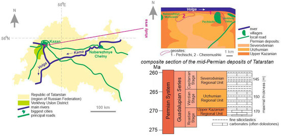
Figure 1.
Geographical (left side) and geological (right side) setting of the study area. The local geological sketch map is modified from Nurgaliev [41]. The correlation of the global and regional mid-Permian standards follows [42]. The global units are colored according to the guidelines in [42].
The largest city of Tatarstan is its capital, namely Kazan (>500 km2, ~1.2 million people). The city’s history dates back to longer than 1000 years ago, and it is one of the most important cultural, educational, financial, industrial, and transport centers of the entire country, as well as a popular tourist destination. The region consists of dozens of smaller administrative units, one of which is the Verkhniy Uslon District (>1400 km2, 17,500 people), which is adjacent to the Kazan metropolitan area (Figure 1). The study area corresponds to the northeastern edge of the district, i.e., to the steep right bank of the very wide Volga River. It is situated near Pechischi (Figure 1).
2.2. Geological Setting
Tectonically, the study area corresponds to the eastern part of the Russian Platform, which is a substantial, stable domain in the central part of the Eurasian lithospheric plate (in its present meaning [43]). Before the mid-Paleozoic, there was a microplate (terrane) called Baltica, which later formed Laurussia together with North America (Laurentia) [44]. Later collisions in the east (with Kazakh terranes and Siberia) marked the onset of growth of the Eurasian plate [45,46], and multiple accretions followed by stabilization in the south (Scythian domain) shaped the present-day Russian Platform [47,48]. More precisely, the study area corresponds to the lengthy, northeast–southwest-oriented Kazan-Kazhim Trough separating the Tokmovo and North Tatarian domes of the Volgian-Uralian anteclise dominating the eastern part of the Russian Platform [49,50].
The study area is dominated by mid-Permian deposits (Figure 1), which were characterized comprehensively by Nurgaliev [41]. A regional standard of their stratigraphy is developed, although its correlation to the global standard is matter for yet-to-be-completed investigations and discussions [34,35,41]. Tentatively, the Sokian (Lower Kazanian) and the Povolzhian (Upper Kazanian) correspond to the Roadian, the Urzhumian corresponds to the Wordian, the Severodvinian corresponds to the Capitanian, and, thus, the four noted regional units (regional stages) constitute the Guadalupian Series [42]. These correlations are based on various paleontological data. In the Republic of Tatarstan, the Middle Permian consists chiefly of carbonates (dolostones and limestones), fine siliciclastics (siltstones and shales, often red-colored), and mixed lithologies (marlstones); their total thickness reaches 500 m [41].
The Guadalupian deposits of the study area formed west of the Hercynian Uralian mountains, at the transition between a landmass with terrestrial, desert-like environments to the west and epeiric seas, shallow water, and shrinking, with brackish and hypersaline lagoons bounded by carbonate buildups [41,51]. Early diagenetic dolostones and sabkha facies are common in the Upper Kazanian marine carbonates and evaporites, and paleosols are common in the Urzhumian terrestrial strata. The paleoclimate was arid. Marine basins differed by configuration and conditions between the Late Kazanian and Urzhumian. Paleoecosystems were rich, as evidenced by the common presence of such fossils as bivalves, brachiopods, conodonts, and foraminifers in the Late Kazanian sea, and tetrapods, fishes, non-marine ostracodes, and bivalves in the Urzhumian lake-like basin [41].
3. Materials and Methods
Two geological localities of the Verkhny Uslon District, namely Pechischi and Cheremushki, are well-known as highly important objects for the understanding of the Upper Kazanian (upper Roadian) and Urzhumian (Wordian) deposits of the eastern Russian Platform, as well as for the international stratigraphical correlation developments [33,41,52,53,54,55,56,57,58]. Detailed stratigraphical, sedimentological, geochemical, paleontological, and palaeogeographical characteristics of these localities are available (see references above), and it would be unreasonable to repeat them. However, it is very urgent to assess these localities in regard to their geoheritage properties, which requires new, special investigation, the outcomes of which are presented in this paper and determine its novelty.
Long-term field investigations in the Verkhny Uslon District, including those coupled with the field educational campaigns for geoscience students from Kazan Federal University, have allowed for accumulating observations, which can be used as materials for geoheritage assessment. Additionally, some information from the available literature has been used.
Several methods have been proposed for geoheritage assessment [1,15,20,59,60,61,62,63]. They have much in common, but they also differ both formally (by algorithms, criteria, and scoring systems) and in terms of their focus on particular aspects of geoheritage and geosites. Importantly, many of these methods are tied too strongly to the European environment, and alternative approaches are necessary for large, non-European countries [64]. The method proposed by Ruban et al. [64] is employed for the purposes of the present study for two main reasons. First, it does not depend on the “traditional”, European geographical contexts of geoheritage studies. Second, it has already been applied in the other regions of Russia [65,66], and, thus, its use in the Republic of Tatarstan contributes to the nationally consistent geoheritage assessment. To avoid repetition of the earlier published methodological notes [64,66], this method is explained below only generally.
Each geosite is assessed by several criteria (they correspond to principal geoheritage properties), for which scores are given (scores are indicated below in brackets) [64,66]. Some scores increase the geoheritage value and some decrease it, and, thus, both positive and negative scores are used. The basic geoheritage property with the highest scores is uniqueness (rank) depending on the spatial scale of rarity of a particular feature. Uniqueness can be local (+50), regional (+100), national (+250), and global (+500). For instance, if the feature represented in this geosite is known from only this locality in the country, but it exists in some other countries, its uniqueness is national, and it receives a score of 250. The next property is the number of geoheritage types represented in a given geosite. According to Ruban [67], these types are geomorphological, tectonic, stratigraphical, paleontological, sedimentary, palaeogeographical, igneous, metamorphic, geochemical, mineralogical, hydro(geo)logical, geothermal, engineering, pedological, economical, geohistorical (history of geological research and exploration), geocryological, cosmogenic, and complex (the latter means co-occurrence of two and more types). The presence of these types can easily be established in each geosite. The scores depend on their number (0 for single type, +10 for two–three types, +25 for four–ten types, and +50 for more than ten types). Accessibility can be easy in populated areas (+25), easy in remote areas (0), and difficult (−25). Vulnerability depends on anthropogenic stress (past, present, or future); any danger can be absent (+25) or potential (0), and the object can be partly damaged (−25) or fully destroyed (−50). An important technical property is the need for interpretation, which can be absent (+25) and require basic (0) or professional (−10) explanations, or even scientific analysis (−25). Scientific, educational, and touristic importance can be scored each depending on whether it is international (+25) or local (0). The aesthetic importance can be low (0), medium (+25), or high (+50). It should be stressed that this property can be addressed only subjectively, but on the basis of a well-justified set of criteria, which are not linked to specific coloring or panoramic views [68]. The total sum of these scores indicates the geosite value, which may require justification of the rank. For instance, any local geosite can have large aesthetic importance, which makes it a regional geosite. Finally, justified rank can be local (<100), regional (100–249), national (250–499), and global (>500). As noted above, this method was tested successfully (it brought meaningful results important for general judgments of geoheritage and further interpretations) in several areas, and not only Russian ones [64,65,66,69].
In addition to such a semi-quantitative assessment, each geosite is described qualitatively by the same criteria. Geoheritage properties, not “purely” geological characteristics, are emphasized in the course of this procedure, although the latter are also considered. In other words, geoheritage assessment is something more than just reporting and explaining geological peculiarities of the particular localities.
4. Results
4.1. Pechischi
This geosite is located in the north of the study area, along the right, steep bank of the Volga River (Figure 1). It is named after a small village located there, and its name also follows the traditional name of the lengthy section of mid-Permian deposits exposed in the high slope of the river’s valley. The geosite is very complex, and it includes several features of different origin (Figure 2).
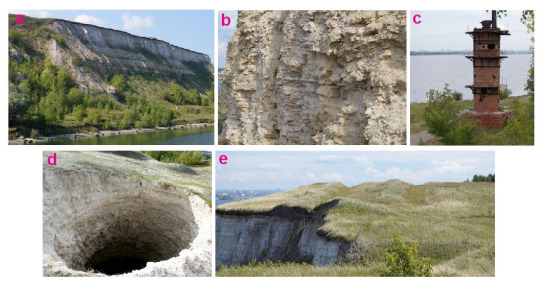
Figure 2.
Pechischi geosite: (a) general view of the Upper Kazanian section, (b) Upper Kazanian dolostones, (c) abandoned oven, (d) karst sinkhole, and (e) combination of karst and landslide phenomena.
The central element of this geosite is the lengthy section of the Upper Kazanian deposits (Figure 2a), among which early diagenetic dolostones prevail (Figure 2b). This is a stratotype of the Upper Kazanian regional unit (possible regional equivalent of the upper Roadian Stage [42]) with clear contacts with under- and overlaying deposits, which have been studied in detail for more than hundreds of years [41]. The deposits bear numerous micro- and macrofossils such as bivalves, brachiopods, bryozoans, conodonts, fishes, foraminifers, gastropods, palynomorphs, and trace fossils, some of which were illustrated by Nurgaliev [41] and Haouz et al. [53] (see also sources cited in these works). These deposits bear celestine crystals and nodules, which are notable mineral features. The section reflects paleoenvironments of the Kazan Palaeosea with sabkhas, lagoons, and a wide tidal zone [51], as well as its paleoecosystems, taphonomical, and ichnological patterns. The other element of the geosite is represented by remnants of the former extractive industry. One of those is an almost complete oven (Figure 2c). Such ovens were used in the 19th century and until the 1930s for burning dolomite “flour” for subsequent use in the local building industry. The latter also required extraction of building stones directly from the exposed slope, which was performed as far back in time as the 16th century. The raw material for processing in ovens was extracted in galleries (up to 3 km in length), which were later abandoned and filled. However, they increased the vulnerability of the rock massif to karst phenomena, as a result of which deep (>15 m) sinkholes were formed (Figure 2b). Therefore, they have mixed, natural, and anthropogenic origin. It should also be noted that when these building resources were exploited, the steep slope was cleaned completely. Further erosion led to its coverage with rock debris. Natural rockfalls of hard, silicified dolomites resulted in the accumulation of huge clasts at the slope toe, which can be classified as coarse boulders and fine blocks (sensu [70]; alternatively, they are boulders sensu [71,72,73]). Yet, the other element of the geosite can be found on the top of the slope where microlandforms demonstrate the coexistence of karst and landslide phenomena (Figure 3e). On the basis of this description, nine geoheritage types can be individualized in the Pechischi geosite (Table 1).
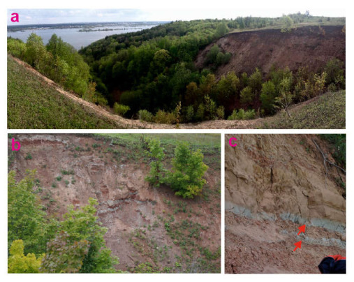
Figure 3.
Cheremushki geosite: (a) general view of the Urzhumian section exposed in the gully; (b) Urzhumian red fine siliciclastics; (c) paleosol horizons (indicated by red arrows; a bag in the lower right corner is provided for scale).

Table 1.
Presence of geoheritage types in the considered geosites (only the present types are listed). The relative importance (low, moderate, or high) is indicated.
The geoheritage represented at Pechischi is peculiar in regard to its basic properties (Table 2) and seems to be a geosite of global relevance because of two reasons. On the one hand, it hosts the stratotype of the Upper Kazanian, which is a stratigraphic unit of international utility because it is essential for the world-scale correlations of the Guadulupian Series [35,42]. On the other hand, this section has major historical importance because it contributes to the understanding of the Permian System in the framework of regional stratigraphical standards developed during more than a century. The accessibility of the geosite is perfect. The outer accessibility has three principal options. The first one requires car/bus transportation from the center of Kazan to Verkhniy Uslon via a bridge, which takes no more than one hour. The second option is to use a car ferry connecting Kazan and Verkhniy Uslon (the time is generally the same in this case). The third option is to use river ships, which operate between Kazan and Pechischi. This option does not allow the use of a car, but the time decreases to ~30 min. The inner accessibility is determined by the availability of local unpaved roads and trails, which lead from the settlements to the riverbank and cross somewhere in the section. The space at the toe of the steep slope is quite wide to allow easy hiking and accommodates even large groups of visitors. The vulnerability of this geosite is minimal because the anthropogenic stress is absent (except for an occasional accumulation of recreational waste in karst sinkholes). Although professional explanations would contribute to a better understanding of the geosite, basic geological knowledge is enough to assess its value. Pechischi has outstanding scientific importance thanks to its value as a stratotype section, richness in fossils, and facies peculiarities. Cutting-edge research has already been conducted there [51,53,56], and there is significant potential for further developments (especially in regard to the global correlation of the Guadalupian Series). The educational importance is determined by the utility of the geosite for explaining a series of geological phenomena to earth science university students, and, in fact, the site is regularly exploited for such purposes by Kazan Federal University with its strong geoscience educational programs. The touristic importance is also high because visiting this geosite allows for raising the visitors’ awareness about the Permian System and the local extractive activities. Presently, geotouristic excursions are occasional, but one should note that Pechischi has been included into the routes of excursions at major international meetings [41]. The aesthetic importance is only moderate and determined chiefly by the picturesque landscape, panoramic views, impressive size of the outcrops, and the unusual view of karst sinkholes and man-made objects (oven).
Table 2.
Semi-quantitative assessment of the considered geosites (scores are indicated in parentheses; see above for the explanation of the scoring system, and more details can be found in [64,66]).
The semi-quantitative assessment of Pechischi indicates that it reaches 675 scores (Table 2). This proves the global relevance of this geosite. It should be noted that the employed scoring system [64,66] allows for reaching a maximum total score of 750, and, if so, the value of the analyzed geosite amounts to 90% of the maximum possible value, which is a tangible proof of major importance.
4.2. Cheremushki
This geosite is located north of the study area and corresponds to the short but deep gully, after which it is named (Figure 1). This gully cuts the steep slope of the Volga River valley. Although the considered geosite also has a certain complexity (see below), the different geological phenomena are linked chiefly to the same feature, namely the above-mentioned gully (Figure 3).
The geosite is dominated by outcrops of the Urzhumian deposits (Figure 3a), among which red terrestrial fine siliciclastics prevail (Figure 3b). This is one of the most important reference sections of the Urzhumian regional unit (possible equivalent of the Wordian Stage [42]), which has been studied for many decades [41]. The intercalation of red siltstones with bluish-grey marlstones is reported here (Figure 3c). These marlstones mark paleosols. Various fossils were found in Cheremushki, and the latter is known as the important locality of non-marine bivalve, fishes, non-marine ostracods, and tetrapods (representatives of both amphibians and reptiles are found) [41]. This section reflects the shrinking of the former wide marine basin, with chiefly continental deposits accumulated on alluvial-lacustrine plains in arid conditions. As for the gully (Figure 3a), it represents a common erosional landform, which is typical to this part of the present-day Russian Plain [40]. This description allows for establishing six geoheritage types in the Cheremushki geosite.
The geoheritage represented at Cheremushki differs from that of Pechischi (Table 2). This seems to be a geosite of regional importance because the reference section facilitates the regional correlation of the Urzhumian unit, but other important sections representing this time slice are available in neighboring localities. The same is true for the paleontological content of this geosite. The accessibility of this geosite is ambivalent. On the one hand, the outer accessibility is perfect, the same as in the case of Pechischi. On the other hand, the inner accessibility is more challenging. One can easily reach the upper part of the gully and observe the sequence of outcrops, as well as spectacular panoramic views towards the Volga River (Figure 3a). However, hiking along the gully and climbing its slopes requires significant training and depends on weather conditions. In other words, the internal part of the gully, offering direct access to the Urzhumian outcrops, is inaccessible to many, if not the majority of visitors. If so, Cheremushki belongs to the category of viewpoint geosites, i.e., geosites from which unique geological features can be observed from a distance [74,75,76,77,78]. The vulnerability of this geosite is minimal because the object remains in its natural state, and anthropogenic stress is absent. The basic geological knowledge seems to be enough to assess this geosite. The international scientific importance of Cheremushki is underlined by its utility for the correlation of the global and regional standards of the Guadalupian Series (the established correlation [42] seems to be only preliminary and requires justifications). Some other worldwide-relevant research projects have been carried out there [33,41,54]. The educational and touristic importance is generally the same as in the case of Pechischi (see above), but here, it is more limited because of the lesser diversity of unique phenomena (Table 1) and lower status of the section as a reference section and not stratotype. Nonetheless, showing this geosite to university students and geology amateurs is a very reasonable opportunity. The aesthetic properties of Cheremushki seem to be high. They are linked to the red color of rocks (contrasting blue river and green vegetation in summer season) and panoramic views (Figure 3).
The semi-quantitative assessment of Cheremushki indicates that it gains a score of 250 (Table 2). This increases the rank of this geosite from regional to national. Taking into account the scoring system [64,66], the value of the analyzed geosite constitutes 33% of the maximum possible value.
5. Discussion and Conclusions
5.1. Perspectives of Protection and Exploitation
Geoheritage, especially when it is of global or national value, requires proper conservation, which includes its effective monitoring, protection, management, and promotion. The related principles and procedures were characterized by Burek [79], Crofts [80], Garcia et al. [81], Neto and Henriques [11], Mariotto et al. [82,83], and Prosser et al. [84,85,86]. In the study area, the intense research and the field educational campaigns for geoscience students from Kazan Federal University provide a unique opportunity to monitor regularly the state of the Pechischi and Cheremushki geosites. Taking into account their scientific and educational importance for local geologists, it is evident that even a minor danger to their natural state will be signaled, with consequent actions.
Even more important is that both considered geosites are designated officially as a Regional Monument of Nature (RMN), which is a particular type of specially protected area in Russia. The Pechischi Geological Section RMN was created in 1972 due to its stratigraphical importance, and the Cheremushki Gully RMN was created in 1986 due to its stratigraphical and paleontological importance [87]. Their status was proven several times (the last time in 2019). The Republic of Tatarstan is responsible for these RMNs. The signs (simple explanatory panels) informing about the features’ names and their peculiarities, permitted activities (excursions and individual access), and protection measures are installed (Figure 4a). This official status establishes several restrictions that enable the avoidance of special or occasional anthropogenic stress. It should be noted that even if RMNs are based on geosites, the two do not necessarily coincide, and geosites commonly occupy slightly larger areas. It is strongly recommended to undertake justification of the limits of the considered geosites, also taking into account the limits of the RMNs.
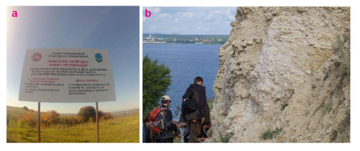
Figure 4.
Geoconservational and geoeducational aspects of the considered geosites: (a) panel informing about the Cheremushki geosite; (b) student excursion to the Pechischi geosite.
Although both objects do not demonstrate any vulnerability, some maintenance is required. The sections can be cleaned from slope debris to reach their historical state (before the local extractive activities were stopped about a century ago). These activities are costly, but simple actions would exhibit more portions of the stratigraphically important sections. Reinforcing the slope to avoid future debris accumulation and occasional collapses may be required in such a case. Similar actions undertaken effectively at the other localities deserve attention [88].
Currently, the exploitation of Pechischi and Cheremushki is related strongly to the educational activities of Kazan Federal University (Figure 4b). Indeed, they can be extended by offering the possibility to visit these geosites to students of some other universities with geoscience programs, which have field educational campaigns. Scientists (chiefly from the noted university, but also from some other institutions and international research groups) work actively at the sections. As for geotourism, it flourishes in the form of occasional academic geotourism, with irregular excursions offered to non-devoted visitors.
Two main challenges for the exploitation of both geosites are the absence of well-established routes and marked trails, as well as the need for interpretive panels explaining the essence of the unique features in detail. In the case of Cheremushki, some engineering solutions would be required for increasing the inner accessibility of the geosite. For instance, metallic stairs could be installed. Indeed, these challenges can easily be addressed, and the necessary investments can be provided by companies and authorities interested in the development of local tourism. The international experience with the infrastructural developments of geosites should also be taken into account [89,90,91,92,93]. The idea of geotrails [94] also deserves attention. More generally, the geosites need development plans to balance exploitation with conservational needs and to avoid even minimal damage of geosites with tourism-related modifications.
5.2. Heritage Complexity in Kazan and Its Vicinity
The recognition of two geosites with high value in the study area (Table 2) raises the question about the correspondence of this geoheritage with the other types of heritage available here. First, it should be stressed that the oven near Pechischi, which is interpreted above in terms of geoheritage, represents also an industrial heritage because it is related to the past industrial activities important for local identity. Such objects as old churches and museums (one of them is dedicated to the famous Belorussian poet, namely Yanka Kupala, who stayed in Pechischi temporarily) comprise cultural and historical heritage of the entire Verkhniy Uslon District. Moreover, the latter is a typical rural district of the Middle Volga territory (but simultaneously urban periphery of Kazan), and, thus, its rural heritage potential is also evident. However, the amount and the diversity of heritage in the urban area of Kazan, at the periphery of where the study area is situated, is impressive, and it has been researched actively [95,96,97,98,99]. This old and multicultural city boasts numerous heritage objects, from which the Historic and Architectural Complex of the Kazan Kremlin is the most important (Figure 5a). In fact, it has the status of UNESCO World Heritage Site.
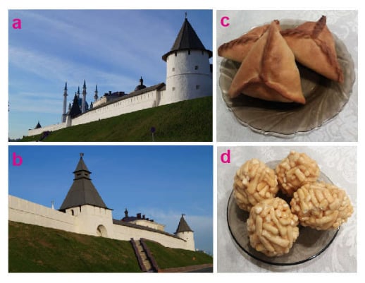
Figure 5.
The Kazan Kremlin: (a) general view of the UNESCO World Heritage Site; (b) details of the Kremlin’s wall; food heritage of Tatarstan: (c) echpochmak and (d) chak-chak.
Generally, Kazan and its vicinity are heritage-rich areas, and, if so, geoheritage contributes to its diversity and value. The spatial integrity of heritage between the study area, the Verkhniy Uslon District, and Kazan is evident. However, this integrity is even stronger, taking into account that dolostones from Pechischi were used for construction of the walls of the Kazan Kremlin in the 16th century (Figure 5b). This permits the tracing of links between the cultural heritage in the city center and the geoheritage at its periphery. One may suppose that the most valuable heritage can be found in the historical center of the city, which seems to be “natural” due to the dominance of the urban peripheries by modern constructions. However, the presence of the geosites with global and national value (Table 2) changes the heritage distribution model, and a part of the urban periphery becomes important in comparison to the center. Indeed, the geosites from the study area mark a kind of frontier of earth science, which struggles to make advancements in the understanding of the Guadalupian stratigraphy and paleontology, and, thus, they extend the general heritage meaning of the urban area of Kazan.
Indeed, the above-mentioned interferences between the geological and other types of heritage of Kazan and its vicinity form a substantial basis for geotourism development. At least, it can be facilitated by the connection to the attractive cultural, historical, and other heritage. There may be some other opportunities. The Republic of Tatarstan and Kazan as its capital are famous for specific food, which is a kind of regional heritage. For instance, such food as echpochmak (Figure 5c) or chak-chak (Figure 5d) are elements of the national identity. Gastronomic tourism flourishes in the region, and it can facilitate geotourism development via mixed experiences. From the international experience, it is known that local food and beverages, which often constitute heritage, enhance geotourism development [100,101,102] and can contribute to geoheritage marketing via geoproducts [103,104]. Taking into account the high level of organization of the tourism-related activities in the Republic of Tatarstan, it appears to be easy to merge gastronomic tourism programs with geotourist excursions referring to the already existing experience of merging gastronomic and cultural-historical tourism. Moreover, such a nature-framed development of gastronomic tourism would contribute to responsible and sustainable usage of food products and waste. The related issues are debated hotly [105,106,107]. Apparently, the integration of gastronomic tourism with geotourism at the urban periphery and in adjacent rural areas can be considered as a powerful strategy to increase skills in pro-environmental behavior of tourists in regard to food.
6. Conclusions
Generally, the present study indicates the presence of two valuable geosites at the periphery of Kazan city. One of them is ranked globally, and another is ranked nationally. These geosites represent a wide spectrum of geological phenomena, although they have much in common reflecting the mid-Permian world. These geosites need some geoconservation initiatives, and their effective exploitation requires infrastructural development. Although it is often thought that geoheritage concentrates in mountainous domains, the present example provides an alternative view demonstrating the presence of unique features in the eastern part of the vast Russian Plain.
This study aims at arguing innovatively that geoheritage on urban areas should be treated together with the other types of heritage (architecture, food, etc.). If so, finding geosites with high value at the periphery of such areas contributes to balancing the general (not only geological) heritage value between center and margins of large cities. This seems to be highly important for rational urban planning and management; particularly, this means that heritage-related initiatives should not be restricted to cultural and historical centers. Apparently, geosites found at the peripheries of urban areas would contribute to their sustainable development via attraction of tourists (with socioeconomical benefits in the form of local income, new jobs, and infrastructure improvement) and homogenization of the city environment with joint heritage management.
The present study reveals the potential of geoheritage exploration in the Republic of Tatarstan. This seems to be a starting point for further research, which should focus on finding and assessing new geosites in this region of Russia. Indeed, a comprehensive geoheritage description of this region cannot be achieved by a single research team, and, thus, significant efforts and several decades of investigations will be required. However, documenting this geoheritage will permit the revealing of new geological resources, the exploitation of which can bring substantial socioeconomical benefits. Additionally, examples from different countries should be compared for the conceptual treatment of geoheritage in the spatial structure of urban environments.
Author Contributions
Conceptualization, D.A.R.; methodology, V.A.E. and D.A.R.; investigation, S.O.Z. and D.A.R.; writing—original draft preparation, D.A.R., V.A.E. and D.A.R.; project administration, S.O.Z. All authors have read and agreed to the published version of the manuscript.
Funding
A part of this work was supported by the Ministry of Science and Higher Education of the Russian Federation under agreement No. 075-15-2022-299 within the framework of the development program for a world-class Research Center “Efficient development of the global liquid hydrocarbon reserves” (contribution of S.O.Z.). The research by V.A.E. and D.A.R. was not funded and was not done within the frame of the above-indicated project.
Data Availability Statement
Not applicable.
Acknowledgments
We thank gratefully the academic editor and the reviewers for their valuable recommendations, as well as the students in geology from Kazan Federal University for their curiosity and education skills.
Conflicts of Interest
The authors declare no conflict of interest. The funder had no role in the design of the study; in the collection, analyses, or interpretation of data; in the writing of the manuscript; or in the decision to publish the results.
References
- Brilha, J. Inventory and Quantitative Assessment of Geosites and Geodiversity Sites: A Review. Geoheritage 2016, 8, 119–134. [Google Scholar] [CrossRef]
- Erikstad, L. Geoheritage and geodiversity management—The questions for tomorrow. Proc. Geol. Assoc. 2013, 124, 713–719. [Google Scholar] [CrossRef]
- Crofts, R. Putting geoheritage conservation on all agendas. Geoheritage 2018, 10, 231–238. [Google Scholar] [CrossRef]
- De Grosbois, A.M.; Eder, W. Geoparks—A tool for education, conservation and recreation. Environ. Geol. 2008, 55, 465–466. [Google Scholar] [CrossRef]
- Dowling, R.K. Geotourism’s global growth. Geoheritage 2011, 3, 1–13. [Google Scholar] [CrossRef]
- Pasquaré Mariotto, F.; Venturini, C. Strategies and tools for improving Earth Science education and popularization in museums. Geoheritage 2017, 9, 187–194. [Google Scholar] [CrossRef]
- Coratza, P.; Bollati, I.M.; Panizza, V.; Brandolini, P.; Castaldini, D.; Cucchi, F.; Deiana, G.; Del Monte, M.; Faccini, F.; Finocchiaro, F. Advances in Geoheritage Mapping: Application to Iconic Geomorphological Examples from the Italian Landscape. Sustainability 2021, 13, 11538. [Google Scholar] [CrossRef]
- Bentivenga, M.; Cavalcante, F.; Mastronuzzi, G.; Palladino, G.; Prosser, G. Geoheritage: The Foundation for Sustainable Geotourism. Geoheritage 2019, 11, 1367–1369. [Google Scholar] [CrossRef]
- Clary, R.M.; Andrews, W.; Connors, T. Geoheritage: Progress toward Preservation. GSA Today 2022, 32, 18–19. [Google Scholar] [CrossRef]
- Gordon, J.E. Geoconservation principles and protected area management. Int. J. Geoheritage Park. 2019, 7, 199–210. [Google Scholar] [CrossRef]
- Herrera-Franco, G.; Carrión-Mero, P.; Montalván-Burbano, N.; Caicedo-Potosí, J.; Berrezueta, E. Geoheritage and Geosites: A Bibliometric Analysis and Literature Review. Geosciences 2022, 12, 169. [Google Scholar] [CrossRef]
- Kaur, G. Geodiversity, Geoheritage and Geoconservation: A Global Perspective. J. Geol. Soc. India 2022, 98, 1221–1228. [Google Scholar] [CrossRef]
- Németh, B.; Németh, K.; Procter, J.N.; Farrelly, T. Geoheritage Conservation: Systematic Mapping Study for Conceptual Synthesis. Geoheritage 2021, 13, 45. [Google Scholar] [CrossRef]
- Neto, K.; Henriques, M.H. Geoconservation in Africa: State of the art and future challenges. Gondwana Res. 2022, 110, 107–113. [Google Scholar] [CrossRef]
- Reynard, E.; Brilha, J. (Eds.) Geoheritage: Assessment, Protection, and Management; Elsevier: Amsterdam, The Netherlands, 2018. [Google Scholar]
- Urban, J.; Radwanek-Bąk, B.; Margielewski, W. Geoheritage Concept in a Context of Abiotic Ecosystem Services (Geosystem Services)—How to Argue the Geoconservation Better? Geoheritage 2022, 14, 54. [Google Scholar] [CrossRef]
- Williams, M.A.; McHenry, M.T.; Boothroyd, A. Geoconservation and Geotourism: Challenges and Unifying Themes. Geoheritage 2020, 12, 63. [Google Scholar] [CrossRef]
- Capdevila-Werning, R. Preserving destruction: Philosophical issues of urban geosites. Open Philos. 2020, 3, 550–565. [Google Scholar] [CrossRef]
- Kubalíková, L.; Balková, M. Two-level assessment of threats to geodiversity and geoheritage: A case study from Hády quarries (Brno, Czech Republic). Environ. Impact Assess. Rev. 2023, 99, 107024. [Google Scholar] [CrossRef]
- Kubalíková, L.; Drápela, E.; Kirchner, K.; Bajer, A.; Balková, M.; Kuda, F. Urban geotourism development and geoconservation: Is it possible to find a balance? Environ. Sci. Policy 2021, 121, 1–10. [Google Scholar] [CrossRef]
- Portal, C.; Kerguillec, R. The Shape of a City: Geomorphological Landscapes, Abiotic Urban Environment, and Geoheritage in the Western World: The Example of Parks and Gardens. Geoheritage 2018, 10, 67–78. [Google Scholar] [CrossRef]
- Reynard, E.; Pica, A.; Coratza, P. Urban Geomorphological Heritage. An Overview. Quaestiones Geographicae 2017, 36, 7–20. [Google Scholar] [CrossRef]
- Wolniewicz, P. Classification and Quantification of Urban Geodiversity and Its Intersection with Cultural Heritage. Geoheritage 2022, 14, 63. [Google Scholar] [CrossRef]
- Comǎnescu, L.; Nedelea, A.; Stǎnoiu, G. Geomorphosites and Geotourism in Bucharest City Center (Romania). Quaestiones Geographicae 2017, 36, 51–61. [Google Scholar] [CrossRef]
- Taha, M.M.N.; Al-Hashim, M.H.; El-Asmar, H.M. Geoarcheomorphosites under Strong Urbanization Pressure at the Tineh Plain, NE of the Nile Delta, Egypt. Geoheritage 2020, 12, 24. [Google Scholar] [CrossRef]
- Hernández, W.; Dóniz-Páez, J.; Pérez, N.M. Urban Geotourism in La Palma, Canary Islands, Spain. Land 2022, 11, 1337. [Google Scholar] [CrossRef]
- Palacio-Prieto, J.L. Geoheritage Within Cities: Urban Geosites in Mexico City. Geoheritage 2014, 7, 365–373. [Google Scholar] [CrossRef]
- Habibi, T.; Ponedelnik, A.A.; Yashalova, N.N.; Ruban, D.A. Urban geoheritage complexity: Evidence of a unique natural resource from Shiraz city in Iran. Resources Policy 2018, 59, 85–94. [Google Scholar] [CrossRef]
- Karpunin, A.M.; Mamonov, S.V.; Mironenko, O.A.; Sokolov, A.R. Geological Monuments of Nature of Russia; Lorien: Sankt-Peterburg, Russia, 1998. (In Russian) [Google Scholar]
- Benton, M.J.; Sennikov, A.G. The naming of the Permian System. J. Geol. Soc. 2022, 179, jgs2021–jgs2037. [Google Scholar] [CrossRef]
- Benton, M.J.; Sennikov, A.G.; Newell, A.J. Murchison’s first sighting of the Permian, at Vyazniki in 1841. Proc. Geol. Assoc. 2010, 121, 313–318. [Google Scholar] [CrossRef]
- Benton, M.J.; Briggs, D.E.G.; Clack, J.A.; Edwards, D.; Galway-Witham, J.; Stringer, C.B.; Turvey, S.T. Russia–UK Collaboration in Paleontology: Past, Present, and Future. Paleontol. J. 2017, 51, 576–599. [Google Scholar] [CrossRef]
- Gomankov, A.V.; Danilova, A.V. Palynological characterization of the Permian reference sections in the Kazan Volga region. Paleontol. J. 2015, 49, 1365–1371. [Google Scholar] [CrossRef]
- Kotlyar, G.V. Permian of the Russia and CIS and its interregional correlation. Dev. Palaeontol. Stratigr. 2000, 18, 17–35. [Google Scholar]
- Menning, M.; Alekseev, A.S.; Chuvashov, B.I.; Davydov, V.I.; Devuyst, F.-X.; Forke, H.C.; Grunt, T.A.; Hance, L.; Heckel, P.H.; Izokh, N.G.; et al. Global time scale and regional stratigraphic reference scales of Central and West Europe, East Europe, Tethys, South China, and North America as used in the Devonian-Carboniferous-Permian Correlation Chart 2003 (DCP 2003). Palaeogeogr. Palaeoclimatol. Palaeoecol. 2006, 240, 318–372. [Google Scholar] [CrossRef]
- Vdovets, M.S.; Silantiev, V.V.; Mozzherin, V.V. A national geopark in the Republic of Tatarstan (Russia): A feasibility study. Geoheritage 2010, 2, 25–37. [Google Scholar] [CrossRef]
- Burganov, F.G. (Ed.) Nature and Natural Resources of the Republic of Tatarstan; AN RT: Kazan, Russia, 2019. (In Russian) [Google Scholar]
- Shaykhutdinova, G.A.; Rogova, T.V.; Mukharamova, S.S. Anthropogenic fragmentation as estimated figures of forest state and sustainability. Adv. Environ. Biol. 2014, 8, 69–73. [Google Scholar]
- Ulengov, R.A.; Khuziakhmetov, A.N.; Nasibullov, R.R.; Yarullin, I.F. Approaches to the environmental assessment of landscapes in the Republic of Tatarstan. Ekoloji 2018, 27, 1713–1717. [Google Scholar]
- Yermolaev, O.P.; Medvedeva, R.A.; Ivanov, M.A. Modern gully erosion in forest and forest-steppe landscapes of the east of the Russian Plain. Geomorfologiya 2021, 52, 28–41. [Google Scholar]
- Nurgaliev, D.K. Type and Reference Sections of the Middle and Upper Permian of the Volga and Kama River Regions; Kazan University Press: Kazan, Russia, 2015. [Google Scholar]
- Gradstein, F.M.; Ogg, J.G.; Schmitz, M.D.; Ogg, G.M. (Eds.) Geologic Time Scale 2020; Elsevier: Amsterdam, The Netherlands, 2020. [Google Scholar]
- Hasterok, D.; Halpin, J.A.; Collins, A.S.; Hand, M.; Kreemer, C.; Gard, M.G.; Glorie, S. New Maps of Global Geological Provinces and Tectonic Plates. Earth-Sci. Rev. 2022, 231, 104069. [Google Scholar] [CrossRef]
- Cocks, L.R.M.; Torsvik, T.H. Baltica from the late Precambrian to mid-Palaeozoic times: The gain and loss of a terrane’s identity. Earth-Sci. Rev. 2005, 72, 39–66. [Google Scholar] [CrossRef]
- Matthews, K.J.; Maloney, K.T.; Zahirovic, S.; Williams, S.E.; Seton, M.; Müller, R.D. Global plate boundary evolution and kinematics since the late Paleozoic. Glob. Planet. Change 2016, 146, 226–250. [Google Scholar] [CrossRef]
- Nikishin, A.M.; Ziegler, P.A.; Stephenson, R.A.; Cloetingh, S.A.P.L.; Furne, A.V.; Fokin, P.A.; Ershov, A.V.; Bolotov, S.N.; Korotaev, M.V.; Alekseev, A.S.; et al. Late Precambrian to Triassic history of the East European Craton: Dynamics of sedimentary basin evolution. Tectonophysics 1996, 268, 23–63. [Google Scholar] [CrossRef]
- Bush, V.A. The deep structure of the Scythian Plate basement. Geotectonics 2014, 48, 413–426. [Google Scholar] [CrossRef]
- Makarova, N.V.; Sukhanova, T.V. Actual problems of studies of recent platform structures: A case study of the East European Craton and adjacent parts of the Scythian Plate. Mosc. Univ. Geol. Bull. 2017, 72, 245–254. [Google Scholar] [CrossRef]
- Lozin, E.V. Deep structure and oil-gas potential of the Volgo-Uralian region and adjacent territories. Litosfera 2002, 3, 46–68. (In Russian) [Google Scholar]
- Shargorodsky, I.E.; Liberman, V.B.; Kazakov, E.R.; Zinatova, M.F.; Girina, I.N.; Ziganshin, A.A. New tectonic scheme of the central regions of the Volga Federal District. Georesursy 2005, 9, 10–13. (In Russian) [Google Scholar]
- Zorina, S.O. Mineralogical composition of the Lower and Upper Kazanian (Mid-Permian) rocks and facies dfistribution at the Petchischi region (Eastern Russian Platform). Carbonates Evaporites 2017, 32, 27–43. [Google Scholar] [CrossRef]
- Zorina, S.O.; Ruselik, E.S.; Il’icheva, O.M.; Netkasova, N.A.; Silant’ev, V.A. Composition and depositional environments of transitional deposits of the lower and upper substages of the Kazanian stage in the stratotypic section of the Cis-Kazanian district. Izv. Vyss. Uchebnykh Zaved. Geol. Razved. 2011, 1, 11–17. (In Russian) [Google Scholar]
- Bel Haouz, W.; Lagnaoui, A.; Silantiev, V.V. A new possible bivalve burrow Oblongichnus solodukhoi from the late Kazanian (middle Permian) stratotype section in Russia. Palaeoworld 2020, 29, 96–107. [Google Scholar] [CrossRef]
- Mouraviev, F.A.; Silantiev, V.V.; Gareev, B.I.; Batalin, G.A.; Vybornova, I.B. Paleosols from the Urzhumian (Middle Permian) reference section, Kazan Volga region, Russia. Int. Multidiscip. Sci. GeoConfer. Surv. Geol. Min. Ecol. Manag. 2018, 18, 387–394. [Google Scholar]
- Nurgalieva, N.G. Reference section of the Upper Kazanian substage: Cyclic regularities. ARPN J. Eng. Appl. Sci. 2016, 11, 6928–6934. [Google Scholar]
- Nurgalieva, N.G.; Ponomarchuk, V.A.; Nurgaliev, D.K. Strontium isotope stratigraphy: Possible applications for age estimation and global correlation of Late Permian carbonates of the Pechishchi type section, Volga River. Russ. J. Earth Sci. 2007, 9, ES1002. [Google Scholar] [CrossRef]
- Nurgalieva, N.G.; Khaziev, R.R.; Gareev, B.I.; Batalin, G.A. Urzhumian stage in geochemical variations. ARPN J. Eng. Appl. Sci. 2014, 9, 757–764. [Google Scholar]
- Nurgalieva, N.G.; Gareev, B.I.; Batalin, G.A. Geochemical variations in the Upper Kazanian (Middle Permian) stratotype section, Russia. IOP Conf. Ser. Earth Environ. Sci. 2020, 516, 012017. [Google Scholar] [CrossRef]
- Bruschi, V.M.; Cendrero, A. Geosite evaluation; can we measure intangible values? Alp. Mediterr. Quat. 2005, 18, 293–306. [Google Scholar]
- Fassoulas, C.; Mouriki, D.; Dimitriou-Nikolakis, P.; Iliopoulos, G. Quantitative Assessment of Geotopes as an Effective Tool for Geoheritage Management. Geoheritage 2012, 4, 177–193. [Google Scholar] [CrossRef]
- Sisto, M.; Di Lisio, A.; Russo, F. Geosite Assessment as a Tool for the Promotion and Conservation of Irpinia Landscape Geoheritage (Southern Italy). Resources 2022, 11, 97. [Google Scholar] [CrossRef]
- Štrba, L.; Rybár, P.; Baláž, B.; Molokac, M.; Hvizdak, L.; Krsak, B.; Lukac, M.; Muchova, L.; Tometzová, D.; Ferenčíková, J. Geosite assessments: Comparison of methods and results. Curr. Issues Tour. 2015, 18, 496–510. [Google Scholar] [CrossRef]
- White, S.; Wakelin-King, G.A. Earth sciences comparative matrix: A comparative method for geoheritage assessment. Geogr. Res. 2014, 52, 168–181. [Google Scholar] [CrossRef]
- Ruban, D.A.; Sallam, E.S.; Khater, T.M.; Ermolaev, V.A. Golden Triangle Geosites: Preliminary Geoheritage Assessment in a Geologically Rich Area of Eastern Egypt. Geoheritage 2021, 13, 54. [Google Scholar] [CrossRef]
- Ruban, D.A. On the duality of marine geoheritage: Evidence from the Abrau area of the Russian Black sea coast. J. Mar. Sci. Eng. 2021, 9, 921. [Google Scholar] [CrossRef]
- Ruban, D.A.; Mikhailenko, A.V.; Yashalova, N.N. Valuable geoheritage resources: Potential versus exploitation. Resour. Policy 2022, 77, 102665. [Google Scholar] [CrossRef]
- Ruban, D.A. Geological heritage of the anthropocene epoch—A conceptual viewpoint. Heritage 2020, 3, 19–28. [Google Scholar] [CrossRef]
- Kirillova, K.; Fu, X.; Lehto, X.; Cai, L. What makes a destination beautiful? Dimensions of tourist aesthetic judgment. Tour. Manag. 2014, 42, 282–293. [Google Scholar] [CrossRef]
- Sallam, E.S.; Ruban, D.A.; Ermolaev, V.A. Geoheritage resources and new direction of infrastructural growth in Egypt: From geosite assessment to policy development. Resour. Policy 2022, 79, 103127. [Google Scholar] [CrossRef]
- Bruno, D.E.; Ruban, D.A. Something more than boulders: A geological comment on the nomenclature of megaclasts on extraterrestrial bodies. Planet. Space Sci. 2017, 135, 37–42. [Google Scholar] [CrossRef]
- Blair, T.C.; McPherson, J.G. Grain-size and textural classification of coarse sedimentary particles. J. Sediment. Res. 1999, 69, 6–19. [Google Scholar] [CrossRef]
- Blott, S.J.; Pye, K. Particle size scales and classification of sediment types based on particle size distributions: Review and recommended procedures. Sedimentology 2012, 59, 2071–2096. [Google Scholar] [CrossRef]
- Terry, J.P.; Goff, J. Megaclasts: Proposed revised nomenclature at the coarse end of the Udden-Wentworth grain-size scale for sedimentary particles. J. Sediment. Res. 2014, 84, 192–197. [Google Scholar] [CrossRef]
- Diniz, M.T.M.; de Araújo, I.G.D. Proposal of a Quantitative Assessment Method for Viewpoint Geosites. Resources 2022, 11, 115. [Google Scholar] [CrossRef]
- Fuertes-Gutiérrez, I.; Fernández-Martínez, E. Geosites Inventory in the Leon Province (Northwestern Spain): A Tool to Introduce Geoheritage into Regional Environmental Management. Geoheritage 2010, 2, 57–75. [Google Scholar] [CrossRef]
- Kubalikova, L.; Kirchner, K.; Kuda, F. Viewpoint Geosites and Their Potential for Geoeducation and Geotourism; Public recreation and landscape protection—With environment hand in hand…: Conference proceedings; Mendel University in Brno: Brno, Czech Republic, 2022; pp. 440–445. [Google Scholar]
- Migo, P.; Pijet-Migo, E. Viewpoint geosites—values, conservation and management issues. Proc. Geol. Assoc. 2017, 128, 511–522. [Google Scholar] [CrossRef]
- Mucivuna, V.C.; Garcia, M.D.G.M.; Reynard, E.; Rosa, P.A.D.S. Integrating geoheritage into the management of protected areas: A case study of the Itatiaia National Park, Brazil. Int. J. Geoheritage Park. 2022, 10, 252–272. [Google Scholar] [CrossRef]
- Burek, C.V. The role of the voluntary sector in the evolving geoconservation movement. Geol. Soc. Spec. Publ. 2008, 300, 61–89. [Google Scholar] [CrossRef]
- Crofts, R. Linking geoconservation with biodiversity conservation in protected areas. Int. J. Geoheritage Park. 2019, 7, 211–217. [Google Scholar] [CrossRef]
- Garcia, M.D.G.; Nascimento, M.A.L.D.; Mansur, K.L.; Pereira, R.G.F.D.A. Geoconservation strategies framework in Brazil: Current status from the analysis of representative case studies. Environ. Sci. Policy 2022, 128, 194–207. [Google Scholar] [CrossRef]
- Pasquaré Mariotto, F.; Bonali, F.L. Virtual Geosites as Innovative Tools for Geoheritage Popularization: A Case Study from Eastern Iceland. Geosciences 2021, 11, 149. [Google Scholar] [CrossRef]
- Pasquaré Mariotto, F.; Antoniou, V.; Drymoni, K.; Bonali, F.L.; Nomikou, P.; Fallati, L.; Karatzaferis, O.; Vlasopoulos, O. Virtual Geosite Communication through a WebGIS Platform: A Case Study from Santorini Island (Greece). Appl. Sci. 2021, 11, 5466. [Google Scholar] [CrossRef]
- Prosser, C.; Murphy, M.; Larwood, J. Geological conservation: A Guide to Good Practice; English Nature: Peterborough, UK, 2006. [Google Scholar]
- Prosser, C.D.; Bridgland, D.R.; Brown, E.J.; Larwood, J.G. Geoconservation for science and society: Challenges and opportunities. Proc. Geol. Assoc. 2011, 122, 337–342. [Google Scholar] [CrossRef]
- Prosser, C.D.; Brown, E.J.; Larwood, J.G.; Bridgland, D.R. Geoconservation for science and society—An agenda for the future. Proc. Geol. Assoc. 2013, 124, 561–567. [Google Scholar] [CrossRef]
- Ochagov, D.M. (Ed.) A Summary List of Specially Protected Natural Areas of Russian Federation, Part II; VNIIprirody: Moscow, Russia, 2006. [Google Scholar]
- Szente, I.; Takács, B.; Harman-Tóth, E.; Weiszburg, T.G. Managing and Surveying the Geological Garden at Tata (Northern Transdanubia, Hungary). Geoheritage 2019, 11, 1353–1365. [Google Scholar] [CrossRef]
- Bollati, I.; Zucali, M.; Giovenco, C.; Pelfini, M. Geoheritage and sport climbing activities: Using the Montestrutto cliff (Austroalpine domain, Western Alps) as an example of scientific and educational representativeness. Ital. J. Geosci. 2014, 133, 187–199. [Google Scholar] [CrossRef]
- Bruno, B.C.; Wallace, A. Interpretive Panels for Geoheritage Sites: Guidelines for Design and Evaluation. Geoheritage 2019, 11, 1315–1323. [Google Scholar] [CrossRef]
- Frey, M.-L. Geotourism—Examining tools for sustainable development. Geosciences 2021, 11, 30. [Google Scholar] [CrossRef]
- Herrera-Franco, G.; Mora-Frank, C.; Kovács, T.; Berrezueta, E. Georoutes as a Basis for Territorial Development of the Pacific Coast of South America: A Case Study. Geoheritage 2022, 14, 78. [Google Scholar] [CrossRef]
- Stroppa, P.; Invernizzi, C.; Paris, E.; Pierantoni, P.P. A space-time journey through the composite Conero Geosite (Marche, Italy): A tool for teaching Earth Sciences at school. Rend. Online Soc. Geol. Ital. 2016, 40, 85–90. [Google Scholar] [CrossRef]
- Alberico, I.; Alessio, G.; Fagnano, M.; Petrosino, P. The Effectiveness of Geotrails to Support Sustainable Development in the Campi Flegrei Active Volcanic Area. Geoheritage 2023, 15, 15. [Google Scholar] [CrossRef]
- Bakhareva, O.; Kordonchik, D. Investments in preservation and development of regional cultural heritage: A library of bim elements representing national architectural and urban-planning landmarks. Archit. Eng. 2019, 4, 39–48. [Google Scholar] [CrossRef]
- Bunakov, O.A.; Rodnyansky, D.V.; Eidelman, B.M.; Grigorieva, E.V.; Bashlykov, T.V. The effective use of heritage sites of the major sporting events in Russia. J. Hum. Sport Exerc. 2021, 16, 427–433. [Google Scholar]
- Khramchenkova, R.; Degryse, P.; Sitdikov, A.; Kaisin, A. Analytical studies of post-Medieval glass bottle marks from excavations at Kazan Kremlin (Russia). J. Archaeol. Sci. Rep. 2017, 12, 25–27. [Google Scholar] [CrossRef]
- Litvin, A.A.; Muratova, D.V.; Galimzyanova, L.R. Historical and cultural heritage as a factor for the tourist development of a city. Eur. Res. Stud. J. 2017, 20, 242–247. [Google Scholar]
- Valeev, R.; Valeeva, R. Formation of Kazan archaeological school and its role in the development of the system of historical and cultural heritage preservation of Russia and Tatarstan. Dialog So Vrem. 2021, 74, 229–239. [Google Scholar]
- Arjana, I.W.B.; Ernawati, N.M.; Astawa, I.K. Tourist attractions of Batur geotourism, Bali. J. Environ. Manag. Tour. 2019, 10, 1399–1404. [Google Scholar] [CrossRef] [PubMed]
- Di Lisio, A.; Sisto, M.; Iscaro, C.; Russo, F. Geotourism and economy in Irpinia (Campania, Italy). Rend. Online Soc. Geol. Ital. 2016, 39, 72–75. [Google Scholar] [CrossRef]
- Pijet-Migoń, E.; Migoń, P. Linking Wine Culture and Geoheritage—Missing Opportunities at European UNESCO World Heritage Sites and in UNESCO Global Geoparks? A Survey of Web-Based Resources. Geoheritage 2012, 13, 71. [Google Scholar] [CrossRef]
- Moreira, J.C.; Do Vale, T.F.; Burns, R.C. Fernando de Noronha archipelago (Brazil): A coastal geopark proposal to foster the local economy, tourism and sustainability. Water 2021, 13, 1586. [Google Scholar] [CrossRef]
- Rodrigues, J.; Neto de Carvalho, C.; Ramos, M.; Ramos, R.; Vinagre, A.; Vinagre, H. Geoproducts–Innovative development strategies in UNESCO Geoparks: Concept, implementation methodology, and case studies from Naturtejo Global Geopark, Portugal. Int. J. Geoheritage Park. 2021, 9, 108–128. [Google Scholar] [CrossRef]
- Filimonau, V.; Ermolaev, V.A. Exploring the potential of industrial symbiosis to recover food waste from the foodservice sector in Russia. Sustain. Prod. Consum. 2022, 29, 467–478. [Google Scholar] [CrossRef]
- Filimonau, V.; Ermolaev, V.A.; Vasyukova, A. Food waste in foodservice provided in educational settings: An exploratory study of institutions of early childhood education. Int. J. Gastron. Food Sci. 2022, 28, 100531. [Google Scholar] [CrossRef]
- Filimonau, V.; Chiang, C.-C.; Wang, L.-E.; Muhialdin, B.J.; Ermolaev, V.A. Resourcefulness of chefs and food waste prevention in fine dining restaurants. Int. J. Hosp. Manag. 2023, 108, 103368. [Google Scholar] [CrossRef]


Disclaimer/Publisher’s Note: The statements, opinions and data contained in all publications are solely those of the individual author(s) and contributor(s) and not of MDPI and/or the editor(s). MDPI and/or the editor(s) disclaim responsibility for any injury to people or property resulting from any ideas, methods, instructions or products referred to in the content. |
© 2023 by the authors. Licensee MDPI, Basel, Switzerland. This article is an open access article distributed under the terms and conditions of the Creative Commons Attribution (CC BY) license (https://creativecommons.org/licenses/by/4.0/).