Abstract
In Italy, the current geography of abandonment is defined by the classification of the National Strategy of Inner Areas (NSIA). The support measures envisaged by the NSIA could contribute to reducing the marginality of inner areas and promote the protection, conservation, and enhancement of historic centres. In this perspective, actions on historical buildings should be selected based on a cognitive process aimed at specifying the phenomena that have led to the progressive abandonment of historical centres and a process aimed at identifying the values and dis-values. This research proposes a ruination model aimed at highlighting the risks that the built heritage of the inner areas are exposed to. This model was implemented for the case of the historic neighbourhood of Granfonte in Leonforte. The model was developed based on a qualitative–quantitative approach aimed at detecting the preservation state and built heritage use; analysing the building fabric development; identifying the ruination drivers; building a building units database; defining a ruination pattern of the building units based on a multivariate regression model; and analysing the predicted ruination scenario. The model can support decision-making processes aimed at the selection of actions to protect and preserve heritage built in marginal areas.
1. Introduction
“All inland municipalities have empty areas” [1] (p. 8). In the scenario proposed by Vito Teti, we find a synthesis of what has long been evidence of the decline of certain parts of towns in the most disadvantaged areas. If by inner areas we refer to territories that suffer from conditions of exclusion and peripherality, the historical centres located in these areas will be more exposed to the phenomena of depopulation and disaffection that have long been evident and widespread in oldest areas [2,3]. However, in the Italian context, despite a proliferation of national plans and policies against depopulation, the state of knowledge on the level of involvement of historic urban heritage and the dynamics at the scale of the built environment remains fragmentary and lacking. This generates uncertainties and a precariousness of content with repercussions on intervention methods. [4]. A systematic survey of the state of deterioration of historical areas in the interior is indispensable for a more robust cataloguing of the centres concerned as well as for analysing the risk of abandonment [5], but it remains elusive [6,7,8].
The literature on the subject has raised the need to define a taxonomy of abandonment. Some research has proposed a synthetic classification based on the identification of three levels of conservation: intact, damaged, or ruined centres [9]. Nevertheless, it was rightly pointed out that the phenomenon of abandonment differs in degrees from total abandonment to depopulation, sense of bewilderment, or memory loss [10]. Other studies have worked on having the taxonomy based on the degree of spread distinguish definitive and partial abandonment [11,12]. Furthermore, this dimension of definitive abandonment is often a media attractor to capture the attention of a wider public. Indeed, some approaches sometimes offer a vision that tends to spectacularise the abandonment and propose a new aesthetic dimension characterised by a taste for this phenomenon [13,14,15].
However, it has been noted that many centres, even those that are in good condition and well serviced, reveal areas that are unhealthy and disused [16]. Therefore, the complex nature of abandonment implies a possible co-presence of different levels of severity which, in situations of prolonged maintenance debt, can evolve to the point of ruination and, in extreme cases, the definitive loss of large areas.
In this context, the case of partial abandonment is problematic; it can generate multiple risk situations in terms of exposure to the ruination of parts of the historical centre, becoming a vulnus for the entire urban environment that is still partly inhabited [17,18]. Moreover, the magnitude of these phenomena hardly emerges from the statistics conducted on a large scale precisely because the abandonment often involve a few urban portions. The interpretation of the ongoing dynamics, therefore, requires an analysis that is more specific and closer to the dimension of the historical built environment; it must be capable of grasping the possible declinations of the phenomenon and analysing the concrete effects on the built environment [19].
Through a more detailed investigation of the case of the historic neighbourhood Granfonte in Leonforte (Enna), our contribution aims to offer a view at the scale of the built heritage by examining the processes of deterioration and ruination due to conditions of disuse and underuse. The proposal is aimed at developing an interpretative model of ruination in order to build a renewed awareness of the risks that the built heritage of inland areas are exposed to. The experimentation on the case study defines a study process oriented at identifying the peculiarities of the processes underway, assessing the actual repercussions of abandonment on the built heritage, and identifying plausible scenarios. Considering the need to draw up plans to tackle the phenomenon of abandonment [2], the chosen study perspective is instrumental to the development of an integrated approach between restoration and evaluation and looks towards results that can be used in the decision-making process. The purpose of this approach is to assess the planning intervention priorities and define possible opportunities for conservation and revitalisation while keeping in mind the values of the urban heritage [20,21].
The paper is organised as follows:
- Section 2 proposes a survey of the ruination phenomenon of the built heritage in historical centres;
- Section 3 introduces the case study of the Granfonte neighbourhood in Leonforte in the metropolitan area of Enna;
- Section 4 illustrates the methodological approach;
- Section 5 reports the results;
- Section 6 proposes some reflections on the results, i.e., on the phenomena detected, namely abandonment pockets, ruination pockets, and the contagion mechanisms of the ruination among building units. The section also identifies the limits and lines of future development of this research;
- Section 7 summarises the main points of the proposed research.
2. Approaches to the Ruination Phenomenon of the Built Heritage
The issues of the progressive deterioration of the historic built environment and ruination can be framed within a broader strand of studies on historical urban fabrics.
In this field, the consolidated methodology adopted in Italy is based on a direct knowledge of the built environment and finds indispensable references in the analysis of the construction process through the observation of transformations in building typology. The studies expounding this approach, often applied to concrete case studies, pose a necessary basis for a critical analysis of the historical settlements [22,23,24].
A second reference is represented by tools with an operational character oriented towards providing guidelines for restoration projects [25,26,27,28]. The study methodology, which is aimed at combining the needs of safety with those of preservation, has already been tested in other historical contexts in both ordinary and post-seismic emergency conditions, and it is based on a structured material analysis. [29,30,31,32,33,34].
The approach includes the analysis of the whole historical centre, which is aimed at the identification of the recurring weaknesses and state of decay of the urban fabric and the qualitative evaluation of its susceptibility to being damaged [35,36,37].
It is performed while trying to detect all factors (constructive, typological, transformative) that are able to affect, positively or negatively, the behaviour of the urban fabric in its current configuration.
This approach can benefit from additional methods that have been tried and tested in other contexts. In this regard, the analysis and interpretation of various photographic sources is a useful tool for documenting and reconstructing the state of the ruins in the previous phases [38].
Recent research, however, offers a different perspective on the theme of ruins and abandonment. Of interest are urban-scale studies that analyse the theme of the loss of centrality of the historic centre and that relate urban forms to their level of use [39].
The theme of historic centres in decline presents further elements of contiguity with the study of rural architecture [40] and, more generally, with the broad strand of research on so-called “vernacular” architecture, of which there is a recent and renewed attention towards and whose vulnerability is frequently associated with a condition of marginality [41,42,43]. The issue is inevitably intertwined with the theme of historical centres in inland areas and the question of their state of ruin, even though in the scientific literature, these themes sometimes seem to move on parallel tracks and according to different scales of attention and study.
3. Materials
In Italy, the classification drawn up within the National Strategy of Inner Areas (NSIA) defines the current geography of abandonment. This public cohesion policy was launched in 2014 with the aim of reversing the demographic decline. It is part of the structural policies envisaged by the European Union to strengthen the economic, social, and territorial cohesion of the most disadvantaged territories [44].
The identification of inner areas derives from the construction of the peripherality indicator that expresses not only a disadvantaged position from a geographic point of view but also a fragility due to the lack of services essential for the community (health, education, mobility) [45]. The classification is based on the identification of “pole” municipalities, also referred to as “service centres”. Based on an increasing degree of peripherality, the remaining municipalities are divided into four categories: belt, intermediate, peripheral, and ultra-peripheral municipalities. In particular, the last three belts (intermediate, peripheral, and outermost areas), which are characterised by a considerable distance from essential services, fall into the status of inner areas. According to the mapping updated to 2020, municipalities in inland areas represent 48.5% of Italian municipalities, with a higher incidence of intermediate areas (24.4%) followed by peripheral areas (19.3%) and ultra-peripheral areas (4.8%) [46,47].
The NSIA proposes a classification of municipalities on the basis of their marginal status due to the lack of essential services [48]. In these areas, the gradual worsening of socio-economic vulnerability has led to the abandonment of the population and the impoverishment of economic activities, generating a migration towards the pole areas that offer more services and greater economic vitality [49]. These processes have strongly impacted older areas, increasing their vulnerability and triggering a progressive emptying of functions and a deterioration of the built heritage.
If appropriately calibrated, the support measures envisaged by the NSIA could reduce the marginality of inner areas and promote the protection, conservation, and valorisation of their historical centres. In this perspective, the actions on historical buildings should be selected on the basis of a cognitive process aimed at specifying the phenomena that led to the progressive abandonment of historical centres as well as identifying the values and dis-values of these heterogeneous heritages [50,51,52,53].
In this research, we propose an interpretative model of the phenomenon of ruination of the built heritage in the historical centres of inner areas that is aimed at supporting the decision-making process for the selection of protection and conservation actions. The characteristics of the built heritage and the level of impairment make it possible to delineate the order of priority of interventions aimed at protection and conservation [54,55]. In this regard, we will develop the model on the case study of the Granfonte neighbourhood in Leonforte.
3.1. The Case Study: The Granfonte Neighbourhood in Leonforte
The case of the Granfonte neighbourhood in Leonforte represents a field of investigation that is of interest for analysis purposes for several reasons. The town of Leonforte is located in the heart of Sicily in the province of Enna. According to the NSIA classification [56], the municipality falls within the Sicilian inner areas and is classified as a peripheral municipality. With just under 13 inhabitants [57], Leonforte lies within the band of medium-small municipalities, a demographic class that is particularly representative in the Sicilian settlement context but which manifests increasingly widespread situations of decline [58].
Leonforte is developed on the slopes of Mount Cernigliere with a linear structure that is strongly constrained by the orographic situation (Figure 1). The oldest neighbourhoods are concentrated to the south and are characterised by a compact built-up area that absorbed the contained demographic growth until the beginning of the 20th century; to the north-east, the most recent expansion appears to instead be marked by a growing urban and commercial sprawl. In the face of a cohesive population decline observable since the post-World War II period [57], a condition of imbalance between the different parts of the city is noted. In fact, while the northern area and its anonymous suburbs remain more attractive and densely populated, the southern edge, corresponding to the oldest area, is in a condition of progressive abandonment and decay (Figure 2). In this context, the historical Granfonte neighbourhood appears as an urban periphery located on the fringes of a larger land periphery. In the neighbourhood, the recognition of the qualities and values of historic buildings is struggling to emerge in the awareness of the community. Thus, the ruined buildings, which are increasingly numerous in the neighbourhood, are perceived as evidence of the disinterest of public actors who have so far not initiated any strategic action for the recovery of the historical town.
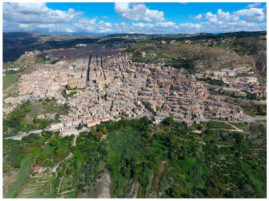
Figure 1.
Aerial view of the southern slope of the town. The interaction between nature and the built environment characterises the southern edge of the town.
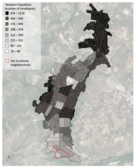
Figure 2.
Resident population in the urban area of Leonforte by census section. Elaboration based on data from the 15th Census of Population and Housing, 2011 [59]. Google Earth Image Overlay (our elaboration).
3.2. Urban and Building Characteristics of the Granfonte Neighbourhood: The Relationship with the Orography and the Dwelling Characteristic
The Granfonte neighbourhood is located on a steeply sloping terrain on the southern flank of Mount Cernigliere. Its settlement condition is a peculiar expression of a rupestrian building culture typical of the central-northern area of the metropolitan area of Enna [60]. Therefore, the coexistence of rock and the built environment is a constant, and the analysis of this relationship is the key to understanding the way in which they are combined. The presence of rocky outcrops and natural constraints conditions the overall layout, i.e., the construction solutions and distribution of houses, which tend to exploit the natural slope to optimise the limited space available [61,62].
The buildings retain a rather modest character. The dwellings have minimal dimensions and are usually developed with only one room per floor for a maximum of two floors; they only reach three levels in areas that are subject to several transformations. Simple volumes are associated with a rather essential architectural vocabulary and extremely simple architectural features. These characteristics are the product of an elementary way of building; nevertheless, it is the result of a building culture that is matured and consolidated over time and based on the precise correspondence between orographic conditions, the formal and structural layout, and specific needs (Figure 3). The most widespread dwellings layouts are the on-slope type and the type with an external staircase (profferlo) [63]. The units stand on a locally varying height difference depending on the slope of the land. It is common to have double access, one upstream and the other downstream, allowing for differentiated entry to the two levels. This layout is evidence of the functional separation of the dwelling from the workplace or even the presence of independent dwellings. In its original conception, the traditional dwelling contained a multifunctional use that was capable of satisfying not only living needs but also work needs in support of the activities carried out in the surrounding countryside (shelter for animals; storage for agricultural products or work tools).
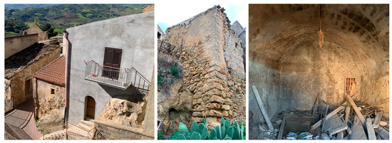
Figure 3.
Examples of dwellings built against the rock outcrop. Depending on the ground conditions, the rock outcrop is often an integral part of the elevation walls. Walls are often built directly on natural rock outcrops; similarly, vaults may have a part directly carved into the rock.
4. Methods
The first phase of the study, aimed at understanding the Granfonte neighbourhood, was part of a group work carried out as part of the departmental project “Conservation of settlements and sites of cultural interest between abandonment and overcrowding” under scientific chiefs C. Carocci and M.R. Vitale.
Following a study methodology adopted in other historical contexts [22,30,31], the investigation was based on an extensive urban survey and allowed us to have preliminary knowledge of the urban morphology, building types, and local constructive technique. We also paid particular attention to the study of the relationships between buildings and the morphology of the site. This analysis was also conducted with reference to other case studies [25].
Following this phase, the methodological approach aimed at defining an interpretative model of the ruination of the built heritage of the internal areas, which was chosen and tested on the Granfonte neighbourhood in Leonforte, is divided into the following phases (Figure 4):
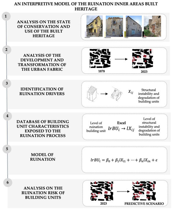
Figure 4.
Flowchart of the methodological approach.
- Analysis of the state of conservation and use of the built heritage;
- Analysis of the development and transformation of the urban fabric;
- Identification of the ruination phenomenon drivers;
- Construction of a database for the characteristics of building units exposed to the ruination process;
- Modelling of the ruination phenomenon for the building units based on a multivariate regression model;
- Ruination risk analysis of the building units;
4.1. Analysis of the State of Conservation and Use of the Built Heritage
This phase of the study consists of an extensive qualitative investigation of the built system and its state of conservation. It allows the situation of the built environment to be documented, highlighting its peculiar characteristics and criticalities. It is also useful to specify the phenomena of abandonment and transformation that is detectable in the neighbourhood.
The documentation underlying this study phase consists of the materials listed below:
- Bibliographic and photographic sources [64,65,66,67,68];
- Cartographies: historical cadastre of 1878 [69]; cadastral map of 2004 provided by the municipality of Leonforte [70]; regional technical map [71]; cadastral plans of some building units [72];
- 2009 Building Use Census [73];
- Basic planimetry of the neighbourhood as drawn up by the above-mentioned working group based on an expeditious and topographical survey [63].
The critical reading of the materiality of the historic built environment was conducted at different scales of observation: the urban scale, the scale of the building aggregate, and the building scale. The analysis of the state of preservation, transformation, and use of the buildings was carried out following a speditive approach, i.e., mainly based on assessments from outside the building units. Where possible, this information has been supplemented with interior inspections or by consulting existing cadastral plans and surveys.
The analysis aimed at characterising the use of the heritage needs some conceptual and terminological clarification.
In this regard, Nuvolati [74] suggested two subgroups for the classification of unused houses based on their state of preservation into empty houses and abandoned houses.
According to this classification, building units in a good state of preservation but with signs of prolonged anthropic absence belong to the category of empty houses; building units with prolonged anthropic absence and clear signs of maintenance debt belong to the category of abandoned houses.
Abandoned houses can evolve into an increasingly pronounced state of disrepair up to localised collapses and thus can be further classified according to their level of damage.
In this regard, it is necessary to introduce a threshold to distinguish between the condition of abandonment and that of overt ruin, conventionally identified by a roof collapse of at least 50%.
4.2. Analysis of the Development and Transformation of the Urban Fabric
At the urban scale, the analysis of the development of the built fabric is useful for detecting the progress of the ruination process over time to understand current problems. This phase of the study makes use of information from additional sources, such as historical photographs available on the Regional Spatial Information System on Google Earth in the years 2000, 2006, 2010, 2013, 2016, 2017, and 2022 [75] and photographs taken by drone [76,77].
The cross-reading of the historical and current land registers, aerial photographs, historical photographs, analyses of cadastral plans, and observations gathered in the field play a decisive role in the reconstruction of the neighbourhood‘s transformative dynamics as they make it possible to highlight demolitions, new constructions, and the progress of roof collapses over time.
4.3. Identification of the Ruination Phenomenon Drivers
Downstream of the urban analysis and at the building scale, it is possible to proceed with a more in-depth characterisation of the phenomenon, which would make it possible to explicate the conditions that activate ruination, the factors of acceleration, or exposure to it.
The identification of the ruination drivers is divided into two phases. The first highlights the critical issues related to the degradation and structural instability present in all building units and makes it possible to progressively distinguish the extent of damage present in the units surveyed as being in a state of ruin [78,79].
The second phase highlights some conditions that can be traced back to the critical aspects of living in the neighbourhood that may have influenced the acceleration of the abandonment process. To this end, this study relates the conditions of conservation and use with certain settlement and architectural characteristics.
4.4. Construction of a Building Units Characteristics Database Exposed to the Ruination Process
The identification of the ruination drivers of a building unit was the basis for constructing an Excel database, in which each ruination level () of the building unit is associated with a level of the building characteristic (). The score representing the ruination level of the building unit will be defined based on some indicators related to the state of preservation of the building elements, which is considered as a proxy for the ruination level of the building units. The items related to the types of degradation and structural instability—partly taken from the sheets of the Risk Map for Historic Centres [80]—may be declined according to classes of predefined types and expressed according to an ordinal scale of increasing severity.
4.5. Modelling of the Ruination Phenomenon and Ruination RISK Analysis
It is possible to model the ruination phenomenon of the building units in the historic neighbourhood of Granfonte by implementing a multivariate regression model in which the dependent variable represents the level of ruination of the building unit ( and the independent variables represent the level of the building characteristic ; is the error term (Equation (1)).
The ruination model can be developed with the help of the statistical software IMB SPSS Statistics 27.
From the results of the multivariate regression model, the most important independent variables can be identified based on the values of the standardised coefficients.
The variables whose standardised coefficient values are greater can support the analysis of the risk of ruination of building units.
The model is therefore functional to the definition of a forecasting scenario of the phenomenon through the identification of the building units most exposed to the risk of ruination, and it is aimed at supporting the definition of an order of priority of protection interventions on the built heritage of historical centres.
5. Results
The analyses allowed us to assess the actual repercussions of marginalisation on the built environment of the Granfonte neighbourhood. The phenomena detected at the urban scale and specified at the building scale reveal a complex and multifaceted nature: they can combine at multiple levels and have multi-scalar effects on the historic built environment.
5.1. The Problematic Nature of Abandonment
The close reading of the urban fabric has made it possible to assess the actual repercussions of the marginalisation phenomenon on the historic built-up area. The analysis of the building use reveals a diversified scenario corresponding to the evident fragmentation of residence: there are buildings in good condition and still inhabited—but often heavily transformed—alternated by empty, abandoned, and even ruined buildings. This investigation, shown in Figure 5, thus clearly highlights the partially abandoned condition of the neighbourhood; in fact, abandoned dwellings account for about half of the total. The critical reading of the building fabric has also made it possible to identify the presence of some building units that should already be considered as in a state of ruin according to the classification adopted here, as they have roof collapses of more than 50%. Some of these appear to be affected by processes of a more advanced ruination as they are involved in serious structural instability. On the other hand, a few building units had a provisional roof following the collapse of the original one.
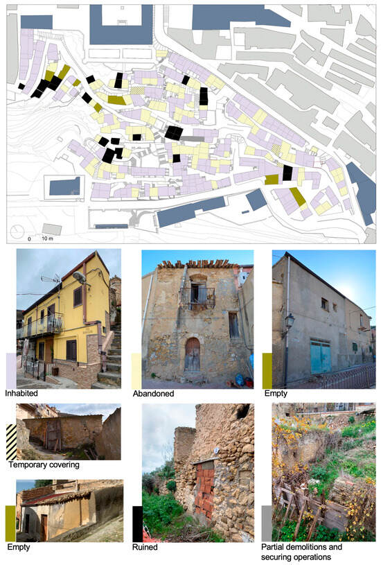
Figure 5.
Survey of buildings according to their use and state of conservation. The analysis reveals a lack of homogeneity of conditions in the historic neighbourhood (our elaboration).
The observation of the distribution of abandoned and ruined buildings highlights certain peculiarities of the residential vacancy. If the abandonment—and sometimes the subsequent phase of advanced ruination—appears to be mainly scattered in the fringe blocks, it is more extensive in the heart of the neighbourhood.
The analytical filing carried out after the field work revealed important criticalities. For example, in the case of more complex aggregative conditions and progressive densification and superelevation, while the upper levels are still permanently inhabited, those downstream are in a state of abandonment for reasons stemming not only from ownership fragmentation but also from poor accessibility or lack of light and air. In such a scenario, the lower floors that are in a condition of prolonged abandonment may even present structural instabilities, which are sometimes resolved using hasty consolidation operations. This is aggravated by the presence of superelevation structures that continue to be inhabited. Abandonment thus generates multiple risk situations with repercussions on both the stability of the buildings involved and those adjacent and on the safety of public routes. The clearly precarious conditions have indeed forced the closure of some roads, but the instability of many buildings continues to represent a vulnus for the entire urban environment (Figure 6).
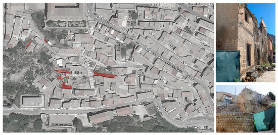
Figure 6.
Roads and urban areas inaccessible for security reasons (our elaboration).
5.2. The Loss of Built Fabric: Ruination and Demolition
The diachronic analysis on an urban scale has allowed us to reconstruct the transformation process of the historic urban fabric. This investigation highlighted the extent of the risks linked to the advancement of the deterioration process and to demolition practices. Based on the cartographic and photographic sources, we prepared a plan that summarised the evolution of the built fabric and presence of ruined buildings through a few significant phases (Figure 7). Consultation of aerial photographs taken over the years made it possible to identify all buildings affected by the collapse of more than 50% of the roof. Maps indicate these conditions one by one.
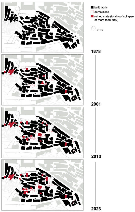
Figure 7.
The built fabric from 1878 to the current situation shows the progress of ruination and, contextually, demolitions. Redrawn on the basis of the current cadastral map. The maps summarise the comparison of historical photographs areas available on the Regional Territorial Information System (RTIS) and on Google Earth, dated 2000, 2006, 2010, 2013, 2016, 2017, and 2022 (our elaboration).
The starting point for the analysis of the ruination process is the cadastral map of 1878. The critical restitution of this map on the basis of the current cadastre led to the recognition of the built areas that have retained an unaltered conformation until today. It is reasonable to assume that at this date, the neighbourhood was very dynamic and free of derelict areas and ruins. The 2001 census already showed that, similarly to what was found for abandonment, ruins also tend to be concentrated in certain areas, forming clusters. In particular, the upper part of the neighbourhood shows a conspicuous presence of ruined buildings that are concentrated particularly at the end of the blind street. Similarly, the aggregate at the bottom, also a dead-end street, approaches becoming a second cluster of ruins alternating with heavily structurally compromised buildings. The condition observed in 2013 clearly appears to have worsened. On the one hand, the number of ruined buildings increases in the vicinity of the two areas already affected by the phenomenon; on the other hand, the process of ruination advances, involving new areas. The snapshot to 2023 shows the extent to which the steady growth of ruined buildings is now a blight on the neighbourhood.
A comparison of the maps shows that, in addition to the rapid advancement of ruination, demolition is practised. Some areas are thus threatened not only by the rapid increase in ruins but also by the progressive (and definitive) loss of built fabric. The aerial photographs show that the collapse of even partial roofs most often constitutes a point of no return; in such situations, recovery or reconstruction are rare, and the building starts a process of incremental decay only mildly counteracted by the placement of a temporary covering. The next step is the total or partial demolition of unsafe parts justified on public safety grounds. The ordinances issued in recent years by the Municipality for reasons of public safety oblige owners to make buildings safe by demolishing unsafe parts and reinforcing the remaining structures. In actual practice, these interventions have been carried out without any particular care and even using mechanical means; some building units with serious structural instability have suffered such damage and collapse that they have (more or less justifiably) led to their total demolition.
In addition to demolition, there is an alternative way of securing the ruins. Following their partial demolition, the buildings have been filled with rubble and waste; they have then been used as supports for terraces and belvederes or as car parks or have been transformed into private vegetable gardens. In this sense, the intervention carried out between vico Vitale and via Risicato is emblematic (Figure 8). The volumes of the houses on the slope, now devoid of roofs, were filled with soil and rubble, following the precarious securing of the facade walls downstream. This intervention is a symptom of an inappropriate way of dealing with the problem of ruins. In fact, in addition to definitively erasing the traces of pre-existing buildings, it is an inadequately designed consolidation operation that does not even ensure a safe response to the new function of being a retaining wall.
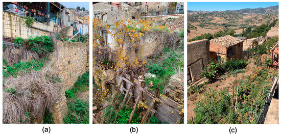
Figure 8.
Partial demolition and securing along and between vico Vitale and via Risicato. (a,b) The downstream situation shows the provisional shoring and partial reconstruction of the retaining wall. (c) Upstream situation with the use of the infilled area as a private vegetable garden.
5.3. Drivers of Ruination
Following the diachronic reading, the survey of all ruined buildings inventoried allowed us to typify the phases of ruination (Figure 9). We schematised it into seven damage configurations, expressing the progressive degeneration of the building in ruin until it reached the state of collapse and total ruination. The reconstruction of this process considered two main parameters that are easily detectable from the outside: the extent of the collapse of the roofs and walls. For the more advanced stages, we added another parameter concerning the collapse of internal structures and floors.
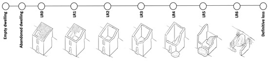
Figure 9.
Scheme of the ruination process (our elaboration).
The first configuration identified is LR0 and concerns buildings affected by deterioration and minor roof or wall collapses, e.g., at openings made close to the guttering line. The on-site analysis made it possible to identify several forms that may be part of the initiation phase of the ruination process. The shapes identified may vary depending on the construction sequence as well as the inherent vulnerabilities [81,82].
The next phase, referred to as LR1, involves a first extension of the collapse of the roof up to 50%. Phase LR2 follows, with the total loss of the roof.
Phase LR3 involves the first collapses of the perimeter load-bearing walls, which is followed by phase LR4, in which more extensive collapses of the walls and the total collapse of the internal floors may also occur. It is worth pointing out, however, that the collapse of floors is a mode of damage that can also affect buildings that still have roofs. These are most frequently metal floors; only occasionally has the collapse of the barrel vault been verified. Phase LR5 is characterised by a very extensive collapse, which may affect the reading of the structural and formal configuration. Finally, phase LR6 consists of a definitive compromise of the configuration.
The extensive qualitative investigation of the built system and its state of preservation allowed for the identification of ruination exposure factors. They may not only depend on the building’s intrinsic vulnerabilities and physical condition, but also on the interaction between contiguous units and the degree of proximity to a ruin. The aggregative modalities typical of masonry architecture involve the construction of building units side by side without interruption and with the presence of at least one shared wall. Such structural contiguity inevitably conditions the mechanisms of degradation and instability triggered by the process of ruination of a building on its neighbouring units.
The study of the evolution of the phenomenon shows that these mechanisms may depend on the construction sequence or be amplified by the presence of intrinsic weaknesses (Figure 10). The position of the openings made close to the masonry ridge represents a vulnerability. This results in a thin masonry portion that constitutes a weakening of the top of the façade. The position adjacent to a ruin can increase the risk of collapse of the top portion of the wall in case of loss of the roof. The extensive collapse of roofs may also weaken the shared wall and induce further collapses of the roofs or floors of adjoining cells. These mechanisms also occur in cases where the extensive collapse of the façade wall leads to the expulsion, even partial, of an incorporated cornerstone, triggering the collapse of a wall portion of the contiguous building. Moreover, as the collapse in the first unit progresses, the adjacent unit will be exposed to an increasing risk of collapse with respect to the shared wall.
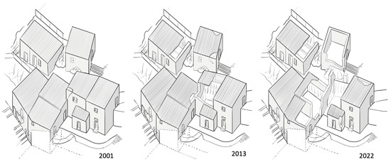
Figure 10.
Study on the progress of collapses in an aggregate. In 2001, the building unit in the centre of the aggregate was affected by a first minor collapse. In 2013, the process advanced with the collapse of the corner and part of the façade and the first damage on the adjacent unit. The contiguousness to a ruin has therefore induced the collapse of the roofs of the adjacent unit. In 2022, there is a progression of collapses that now also extends to the lower cell with which the unit shares a load-bearing wall. At present, the unit at the far end, adjacent to the first ruin, also shows marked signs of decay that attest to the beginning of ruination (our elaboration).
The aerial photographs show the progression of the phenomenon just described. This is clear in the aggregate along via Cassarà. The extensive collapse of the roof of the corner cell, which acts as a link between the two parts of the aggregate, was followed by the collapse—at first minor and then extensive—of the roofs of the adjacent cells (Figure 11).
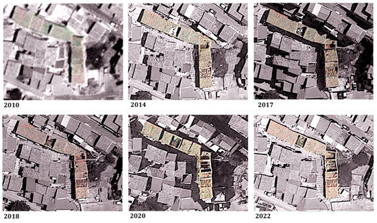
Figure 11.
The progress of the collapse along via Cassarà. Elaboration based on area photographs from SITR and Google Earth (our elaboration).
The analysis of abandonment and ruination has highlighted some conditions related to the criticality of living in the neighbourhood that may have influenced the acceleration of these processes. In addition to the state of maintenance, intrinsic vulnerabilities, and type of interaction with neighbouring units, it is possible to detect an intrinsic propensity for abandonment for some building units. Given that the determining causes of the decline of these areas depend on a multiplicity of external factors, these processes would also be supported or amplified by reasons internal to the very nature of the buildings, which would be linked to some settlement and architectural features.
The first noticeable condition is the marginalisation of specific areas due to difficult accessibility. Figure 12a shows that the more accessible building units tend to be more inhabited, while the less accessible are generally empty, abandoned, or in a state of ruin. Figure 12b highlights how the relationship with the slope can influence the condition of use of the building unit. Figure 12c,e show a prevalence of elevation and planimetric transformations in building units in use, while those that are transformed are in a state of abandonment or ruin. Figure 12d highlights the relationship between the contiguity to ruins and the abandonment or ruination of building units.
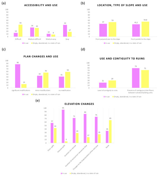
Figure 12.
Relationship between the conservation and use conditions and certain settlement and architectonic characteristics of the building unit (our elaboration).
On the basis of these analyses, it was possible to identify the following determinants of the phenomenon of ruination: characteristics linked to the building type and its degree of transformation, type of relationship with the morphology of the site, level of accessibility and use, type of interaction between adjoining units, and the condition of conservation of building components. The following paragraph will highlight the hierarchical scheme of factors favouring the ruination.
5.4. Database of the Characteristics of Building Units Exposed to the Ruination Process
The results of the observations and analyses have led to the construction of a database. It collects information regarding the general characteristics of the building unit (analysis of the configuration and typology with the relative transformations, analysis of the use, and accessibility) and the state of conservation of the structural elements and building components.
The database, contained in an Excel framework, highlights for each building unit the possible state of ruin, specifying its severity levels, and offers a specific description of the drivers previously identified (Table 1).

Table 1.
The structure of the database of building units.
Two damage thresholds indicate the level of ruination: the extent of collapse for roofs and walls. A score of 1–6 defines each ruination level of the by expressing a damage level of increasing severity, i.e., score 1—total roof collapse (100%) and wall collapse of 70%; score 2—total roof collapse (100%) and wall collapse of 51–70%; score 3—total roof collapse (100%) and wall collapse of 21–50%; score 4—total roof collapse (100%) and wall collapse of 20%; score 5—total roof collapse (100%) without wall collapse; score 6—roof collapse over 50% without wall collapse.
The factors related to ruination are declined through a hierarchical structure and are made explicit by a score indicating a level or type of the building characteristic (score 1-p) according to a range spanning from the most severe or problematic condition to the least severe or problematic condition.
- Typological characteristics—period of construction: score 1—buildings before 1878; score 6—buildings after 2005;
- Typological characteristics—B.U. layout related to the aggregate: score 1—isolated; score 2—corner; score 3—at the end; score 4—interlocked;
- Typological characteristics—B.U. layout related to the proportions of the slope: score 1—substantial slope; score 2—steep slope; score 3—moderate slope;
- Typological characteristics—B.U. position related to the slope: score 1—parallel position; score 2—perpendicular position;
- Typological characteristics—plan changes: score 1—significant changes; score 2—medium changes; score 3—minor changes; score 4—no changes;
- Typological characteristics—elevation changes: score 1—floor uplift; score 2—volume uplift; score 3—insertion of a terrace; score 4—insertion of a mezzanine/mezzanine; score 5—changes to the shape and position of the staircase;
- Building use: score 1—abandoned; score 2—empty; score 3—use different from the original; score 4—in use;
- Accessibility: score 1—difficult; score 2—medium-difficult; score 3—medium-easy; score 4—easy;
- Elevation walls—No. of shared walls with contiguous B.U., No. of floors contiguous to ruins, level of contiguity to ruins, surface degradation, masonry slackening, out of plumb, expelled wall surface (cornerstones, wall covers), material disintegration: score 1—severe; score 2—medium; score 3—mild; score 4—absent. Walls collapse: score 1—more than 70%; score 2—70–51%; score 3—50–21%; score 4—20–1%; score 5—absent;
- Floors: Floors collapse: score 1—100%; score 2—more than 70%; score 3—50–21%; score 4—20–1%; score 5—absent;
- Roofs—Breaking of parts/water infiltrations: score 1—severe; score—medium; score 3—mild; score 4—absent. Roof collapse: score 1—100%; score 2—more than 70%; score 3—50–21%; score 4—20–1%; score 5—absent;
- Openings: Reduced lintel: score 1—s < 70 cm; score 2—s = 70 cm. Efficacy of wooden lintel: score 1—not efficacious; score 2—efficacious;
- Protruding volumes/elements—Gutter collapse: score 1—100%; score 2—more than 70%; score 3—50–21%; score 4—20–1%; score 5—absent.
5.5. Predicted Ruination Risk Scenario
The multivariate regression model defined in Equation (1) was used in order to investigate whether the data selected in the database identified a law for the ruination of the Granfonte neighbourhood in Leonforte. The analysed model is characterised by the dependent variable representing the level of ruination of the building unit ( and by the 24 independent variables representing the level of the building characteristics , as highlighted in the previous table.
The multivariate regression model was developed with the help of IMB SPSS statistical 27 software (Equation (2)).
The goodness-of-fit index of the model is expressed by the value, which represents the proportion of the variance of explained by the explanatory variables. The variance explained by the model is 78.3% (Table 2). The difference between and is modest and does not seem to suggest the presence of redundant independent variables.
Table 2.
Goodness-of-fit statistics.
The F-statistic used for hypothesis testing is significant for p < 0.0001 (Table 3).
Table 3.
Verification of goodness-of-fit assumptions.
The t-statistics for the variables X15, X18, X23, and X24 all turn out to be associated with probability values of less than at least 0.05, so it can be concluded for them that all the regression coefficients are significantly different from zero; only the regression coefficient X23 has a probability of slightly more than 0.05 (Table 4).
Table 4.
Regression coefficients t-statistics.
The most important independent variables are those highlighted with reference to the values of the standardised β coefficients. In particular, the independent variables in order of importance are X18—Walls collapse, X15—Out of plumb, X21—Roof collapse, X23—Wooden lintel efficacy, and X24—Gutter collapse. The VIF statistic commonly used to detect the existence of multicollinearity in the regression model shows that all variables have a value ranging between one and five, which indicates a moderate correlation between a given predictor variable and other predictor variables in the model (Table 5).
Table 5.
Variance inflation factor of predictors.
The analysis of the residuals, supported by the Durbin–Watson statistic, which was used to detect the presence of autocorrelation, shows a calculation value of 1.908, i.e., a normal value (Table 6).
Table 6.
Durbin–Watson statistics.
Equation (3) represents the ruination model of the building units for the Granfonte neighbourhood in Leonforte:
The estimated ruination model provides information on the current condition of building units and is able to provide a forecast scenario on the evolution of the phenomenon, highlighting the building units most exposed to future ruination. The model, therefore, can support the analysis of the risk of ruination of building units.
The most important independent variables identified on the basis of the values of the standardised β coefficients, i.e., with reference to the ruination drivers detected in the building units, X18—Walls collapse, X15—Out of plumb, X21—Roof collapse, X23—Wooden lintel efficacy and X24—Gutter collapse, can support the identification of the units whose condition may worsen in the future or which may not yet be affected by the ruination phenomenon and for which it may be activated.
Figure 13 takes up the study of the evolution of abandonment and ruination, proposing a comparison between the current state of ruination of building units and the forecast state as generated on the basis of the estimated model results.
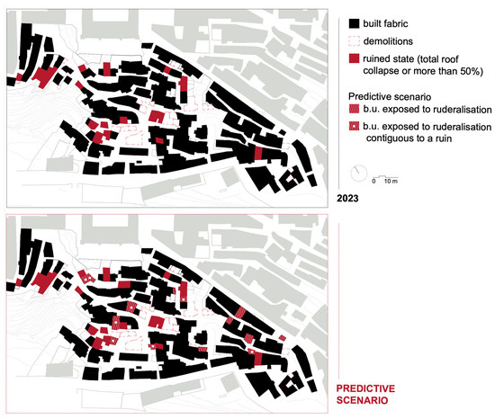
Figure 13.
Comparison of the ruination phenomenon between the current and forecast scenarios.
The model shows a prediction scenario in which the state of ruination of some building units also extends to adjacent ones, i.e., the cases highlighted with the hatching in Figure 13. This scenario shows how some building units that are not currently affected by the ruination phenomenon will be affected in the future, i.e., the cases highlighted with a white square in the same figure.
This scenario highlights the risks that depend on proximity to a building unit in a state of ruin, and overall, it shows a progressive extension of the ruination phenomenon into the historical fabric.
6. Discussion
The results of our research shed light on the possible risks to which the historical centres of towns in inland areas are exposed. The focus on the case study, conducted through direct knowledge of the built environment, has allowed us to specify the processes underway and show and conceptualise some peculiarities. The precise reading has made it possible to identify at the urban and architectural scale the predisposing and accelerating factors that the progressive degeneration depends on and which factors may facilitate the triggering of the phenomenon or amplify its effects.
6.1. Conceptualisation of the Phenomena Detected: Abandonment Pockets, Ruination Pockets, and the Contagion Effect
The case of the Granfonte neighbourhood shows how partial abandonment, which generates the fragmentary nature of residence, can produce quite contradictory situations at the scale of the built-up area. Within the historical area, a substantial coexistence has in fact been observed between buildings still inhabited and often heavily transformed with those in disuse and in a state of disrepair.
The analysis of the development also revealed a peculiar way in which the processes of abandonment and ruination advance over time. One of the peculiar aspects that emerged relates to the tendency of abandonment to be concentrated in specific areas. In analogy to what has already been observed in the context of territories with high instability and natural hazards, the “abandonment pockets” mode can also be observed in our study area [16] (p. 279). This characteristic distribution of the phenomenon thus makes it possible to explicate at the urban scale the dynamic that the anthropological narrative on abandonment describes as the «closure of a part of the built-up area» [1] (p. 7), which is correlated with the type of partial abandonment.
In fact, in the Granfonte neighbourhood, large pockets of abandonment can be observed, especially in the central aggregates that are difficult to access, and in the areas that are close to the slope with a high gradient.
It is easy to see that the least accessible portions of the urban fabric coincide with those affected by the most marked processes of abandonment and decay, so that the level of difficulty of the route to reach the dwellings has had a significant impact on the fate of large pockets of historic buildings.
The choice to interrogate the modes of interaction between contiguous units has made it possible to specify the processuality of abandonment. In fact, our analyses show that in the vicinity of an area already affected by ruination phenomena and serious structural disruption, it is rare for houses to be re-inhabited. The presence of pockets of abandonment acts as an accelerator of the process of deterioration and ruination of the area.
The study of the evolution of ruination over time has thus shown that, like abandonment, ruination also tends to persist in contiguous areas. This mode, which we might call «ruination pockets», represents the evolution of abandonment by pockets and may increase the risk of exposure of the contiguous cell to ruination.
We have verified how the concentration of ruination buildings in certain urban portions and their prolonged abandonment by pockets can trigger cascading mechanisms on contiguous units, compromising the continuity of use for the entire building aggregate. These risks loom clearly from the forecast scenario elaborated on the basis of the proposed ruination model; Figure 13 shows that more than half of the units exposed to future ruination are contiguous to units already surveyed as being in a state of ruin.
We could therefore speak of a contagion effect, which has already been observed in some studies on a territorial level in the context of neighbouring settlements [83] and which is also easily found on an urban scale in the area under study.
But the contagion effect manifests itself not only at the level of structural behaviour but also at the social level. On the structural level, as shown in the results, contagion is a mechanism that depends on the construction characteristics of masonry buildings and calls into question the interaction between adjoining units. On the level of social and human perception, the dilapidated and unsafe condition of neighbouring buildings not only exacerbates the discomfort of those who remain but continues to feed a damaging process to the point of driving the last surviving inhabitants out of their homes.
The process observed in the neighbourhood can thus be represented by the diagram in Figure 14. Prolonged abandonment by pockets induces the initiation of ruination. The contagion effect triggers further mechanisms that generate ruination pockets, which continues to feed contagion mechanisms on the neighbouring units.
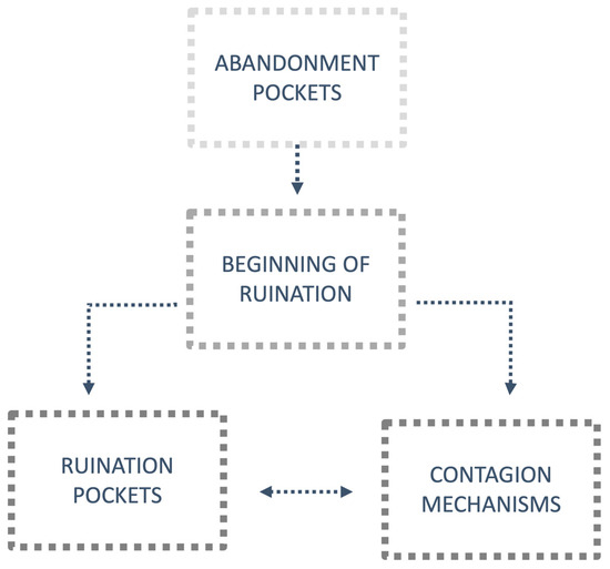
Figure 14.
Diagram of the ruination process detected in the Granfonte neighbourhood.
6.2. Considerations on the Results of Modelling the Phenomenon
The model developed for the Granfonte neighbourhood related the level of ruination of the building units to the selected variables in order to test the possibility of representing the ruination phenomenon in a quantitative manner. This resulted in an equation that can be considered representative of the phenomenon in the neighbourhood.
It is certainly significant that, compared with the initial 24 independent variables identified at the origin of the question, those highlighted by the model are consistent with the expectations derived from the qualitative investigation of the ruination progress. This reinforces the decision to translate the measurement of the phenomenon under study into the two damage thresholds relating to the collapse of load-bearing walls and roofs.
The results of the model were also subjected to a counter-verification based on a qualitative reconnaissance of the units that the law highlighted as most at risk of ruination. The verification, based on the direct feedback of the units reported by the model, provided satisfactory results that were compatible with our expectations.
The forecast scenario obtained from the application of the ruination model is therefore corroborated by direct observation. These results reinforce the intention to objectify ruination with the support of an integrated multidisciplinary methodology.
Making use of the synergic relationship between “restoration” and “real estate appraisal and evaluation”, our experimentation led to the first definition of a study method that aimed to measure itself against the complexity of a historic centre and the phenomena affecting it. The transversal nature of the topics we dealt with suggested that we attempt to integrate a quantitative approach proper to the sphere of the disciplines of “real estate appraisal and evaluation” with a qualitative one oriented towards the study of the existing through the methodological tools of the discipline of “restoration”.
The results obtained from our research are therefore in line with the broader and multi-perspective view wherein it is now considered essential to address the problem of the abandonment of historic centres [84].
Our experimentation seems to confirm the extent to which the possibility of offering a revitalisation opportunity for historic centres in decline must derive from a preliminary knowledge of the dynamics at work, not only on a territorial scale, but also with respect to the built dimension. The identification of the building units most exposed to the threat of ruination is configured as a crucial step in this methodological path that can certainly be transferred to similar contexts. From the perspective of future research development, the qualitative analysis on existing buildings could be enriched by a more precise investigation of the structural situation in order to further explicate the vulnerabilities of the building in relation to construction techniques, the distribution and structural layout, and the relationship with the site. This investigation, which was not dealt with in this study, would make it possible to establish the methods of intervention and design the most appropriate safety and consolidation works. A further development of this research could concern the development of a ruin risk model based on Monte Carlo analysis.
6.3. Remarks
A more in-depth reading of the conditions of abandonment and ruination at the scale of the built-up area has revealed significant critical issues that allow for further reflection on the subject. Forced cohabitation with ruins and abandoned buildings, which have become real waste places, fuels understandable unease in the resident population and generates conditions of insecurity that are hastily resolved through drastic demolition operations.
6.4. From the Perspective of the Local Policies
From the perspective of local policies undertaken to cope with the phenomenon of abandonment, we could analyse the attitudes detected by using the classification already proposed in the context of research on areas in demographic decline, such as the one proposed in the Netherlands case [85].
In the case of the Granfonte neighbourhood in Leonforte, we find a twofold trend. The first is the “do nothing” [85] (p. 67) approach that reflects the inertia of the administrations in the face of the problem of abandoned and dilapidated buildings and is the cause of the rapid advance of decay.
In the neighbourhood, these situations continue to be hastily resolved by closing off the areas at risk to pedestrians. The second approach is defined as “radical” [85] (p. 67) and is expressed in the final solution of demolition which, from being an extreme ratio, begins to be repeated in a worrying way. The lack of a strategy and recovery plan for the historic area demonstrates the recourse to such operations as an attempt to respond to the difficult problems of housing and social hardship that afflict the neighbourhood [86]. The recurring failure to provide an opportunity for conservation through properly designed safety measures demonstrates the lack of a technical culture that is capable of relating to these architectures and grasping their value.
The decline and state of fragility observed today in the historic neighbourhood of Granfonte can certainly be seen in many historic urban contexts in inner areas.
This study shows how the scenario that unfolds under the assumption of the continued “do nothing” approach is quite alarming. In the absence of immediate action, the advancement of the deterioration process threatens to permanently compromise extensive portions of the city with the risk of very serious losses because it is precisely the prolonged abandonment that has helped to preserve authenticity values. As an alternative to the advancement of ruination, the high degree of dilapidation prefigures radical interventions for these heritages, such as demolition, reconstruction, or replacement, with the risk, even in this case, of definitive material disappearance.
However, these results are not very encouraging and highlight the need to address the depopulation of centres in inner areas by building a renewed awareness of the risks that ancient urban structures are exposed to. The state of decay afflicting the built heritage is often such that rehabilitation is considered unsustainable and uneconomic. The most frequent consequence is a deadlock that further fuels the exodus from the historic neighbourhoods.
In spite of an established culture that considers the built heritage as a non-reproducible resource, more recent attention has focused on the fact that its economic value is not compensated by its destruction [87]. Consistent with the necessary promotion of a sustainable use of resources and territories, it therefore seems essential to consider these permanencies as potential for development, defining actions that are able to fully exploit their value as a community asset and resource for the future.
What has been illustrated highlights the need to address the risks associated with abandonment by disengaging from the all-encompassing analysis perspective that seems to characterise the issues of demographic shrinkage [88,89,90,91,92] and rural [93,94,95] and inner areas [45] that is now emerging in the scientific debate. Although related to the phenomena investigated in this study, the approaches adopted still appear to have little focus on built heritage issues.
6.5. From the Perspective of Conservation of the Built Heritage
The preservation of non-monumental urban ruins has been approached in three distinct ways. The first method focuses on maintaining the memory of a traumatic event that led to the abandonment of a place, such as the examples seen in Gessopalena, Italy [96], and Oradour-sur-Glane, France [97]. The primary objective here is to freeze the ruins in their current state and transform them into a monument.
The second approach aims to restore the liveliness of historic settlements that are still inhabited. This is accomplished by preserving the ruins and integrating them into public spaces to enhance the overall character of the city. Notable examples can be seen in the interventions carried out in Salemi, Italy, by Alvaro Siza and Roberto Collovà [98] and in Bocairent by Carlos Campos Gonzalez, Miguel Del Rey Aynat, Antonio Gallud Martínez, and Maria Teresa Santamaria Villagrasa [99].
The third approach, as described by Sebastian Franco in 2020, involves a controlled decay or ruination. In this case, minimal interventions are made to delay the decay of the ruins for as long as possible without completely halting it [100].
The latter practice has been recently conceptualised [101], but a specified approach or extensive studies on this topic still need to be established. The authors emphasise the importance of viewing decay not only as a threat but also as a change to management. Also, they note that conservation should be considered a tool for managing change, with an understanding that different drivers of change pose unique challenges for heritage management. As such, sustainable changes may be necessary, even if they could cause harm, while repairs should be carried out within a long-term plan that considers the inevitable changes and decay.
A complex landscape—such as that of a fragmented wall fabric by the presence of ruined, often unsafe buildings adjacent to still inhabited buildings—forces us to ask ourselves some essential questions that will have to guide our investigative activity. Is it still possible to preserve something while ensuring adequate security for those who still inhabit those places?
In the case of the Granfonte neighbourhood, the situation requires reconstituting the status of a vital neighbourhood and not creating an open-air museum or the provisioning that characterises post-disaster urban landscapes. The approach demanded is thus the same as a restoration and conservation project. However, the goal is that of an «adaptive release» [101] (p. 6) or controlled non-maintenance [102]. This perspective aims to manage change and seek to go beyond well-established approaches for actively managing change to ensure the continued use and enjoyment of a place whilst reinforcing its historic significance.
7. Conclusions
The research set itself the objective of developing an interpretative model of ruination in order to shed light on the risks that the built heritage of inland areas is exposed to. The study, applied to the case of the historical Granfonte neighbourhood in Leonforte, adopts an integrated approach between qualitative and quantitative analyses. Direct knowledge of the built heritage made it possible to identify the ruination drivers. The analysis shed light on some peculiarities of the dynamics at work that can be traced back to the mode of abandonment pockets and the advancement of ruination produced by contagion mechanisms. The research therefore develops a model of ruination that has made it possible to identify the building units most exposed to the threat of ruination, outlining a forecast scenario in the hypothesis of the continuation of an attitude effectively described by the expression “do nothing”.
This experimentation has led to the first definition of a study method that lends itself to being transferred to similar contexts, with a view to a future decision-making phase that, backed up by knowledge of the critical aspects of the historical area, is able to guide strategic choices and support the protection and conservation of the built environment.
Author Contributions
Conceptualisation, D.S. and M.R.T.; methodology, D.S. and M.R.T.; software, M.R.T.; validation, M.R.T.; formal analysis, M.R.T.; investigation, D.S.; resources, D.S. and M.R.T.; data curation, D.S. and M.R.T.; writing—original draft preparation, D.S., M.R.T. and C.C.; writing—review and editing, D.S., M.R.T. and C.C.; visualisation, D.S. and M.R.T.; supervision, M.R.T.; project administration, M.R.T.; funding acquisition, M.R.T. All authors have read and agreed to the published version of the manuscript.
Funding
This work was financed by the University of Catania in a project entitled “Architettura a Rischio: Demolire, Recuperare, Restaurare. Il tema della qualità nel progetto sul patrimonio—ARDeRe, scientific responsible De Medici S.”, which is part of the general project “Piano della Ricerca Dipartimentale 2020–2022 of the Department of Civil Engineering and Architecture”.
Data Availability Statement
Not applicable.
Conflicts of Interest
The authors declare no conflict of interest.
References
- Teti, V. Quel Che Resta: L’italia dei Paesi, Tra Abbandoni e Ritorn; Donzelli: Roma, Italy, 2017. [Google Scholar]
- ANCSA; CRESME. Centri Storici e Futuro del Paese. Indagine Nazionale Sulla Situazione dei Centri Storici; ANCSA: Roma, Italy, 2017; Available online: http://www.cresme.it/doc/rapporti/Centri-storici-e-futuro-del-Paese.pdf (accessed on 4 April 2022).
- CERTU. Centralité dans la ville en mutation. In Quelles Perspectives D’action Pour les Pouvoirs Publics? CERTU: Lione, France, 2003. [Google Scholar]
- Fiorani, D. Il futuro dei centri storici. In Digitalizzazione e Strategia Conservative; Quasar: Roma, Italy, 2019. [Google Scholar]
- Gizzi, F.T.; Bentivenga, M.; Lasaponara, R.; Danese, M.; Potenza, M.R.; Sileo, M.; Masini, N. Natural Hazards, Human Factors, and “Ghost Towns”: A Multi-Level Approach. Geoheritage 2019, 11, 1533–1565. [Google Scholar] [CrossRef]
- Pavan, C.; Pavan, N.; Semenzin, C. Osservare per governare un territorio. In Il Bel Paese; Un Progetto per 22.621 Centri Storici; Albrecht, B., Magrin, A., Eds.; Rubettino: Saveria Mannelli, Italy, 2017; pp. 118–133. [Google Scholar]
- Fiorani, D. Metodologie d’indagine sul problema dell’abbandono dei centri storici. Un’introduzione. ArchHistoR 2020, 13, 675–681. [Google Scholar]
- Trovato, M.R.; Nasca, L. An Axiology of Weak Areas: The Estimation of an Index of Abandonment for the Definition of a Cognitive Tool to Support the Enhancement of Inland Areas in Sicily. Land 2022, 11, 2268. [Google Scholar] [CrossRef]
- Iannotta, F. Ghost towns and housing discomfort: The landscapes of risk in Italy. UPLanD 2016, 4, 273–300. [Google Scholar]
- Pazzagli, R. Un Paese di Paesi. Luoghi e Voci dell’Italia Interna; ETS: Pisa, Italy, 2021. [Google Scholar]
- Bassanelli, M. Geografie dell’abbandono. La dismissione dei borghi in Italia. Master Degree Thesis, Politecnico di Milano, Milano, Italy, 2010. [Google Scholar]
- Coletta, T. I Centri Storici Minori Abbandonati della Campania; Conservazione, Recupero e Valorizzazione; Edizioni Scientifiche Italiane: Naples, Italy, 2014; ISBN 8849520611. [Google Scholar]
- Telford, L. English Nationalism and Its Ghost Towns; Routledge: Abingdon, UK, 2022; pp. 1–156. [Google Scholar] [CrossRef]
- Batty, M. Empty buildings, shrinking cities and ghost towns. Environ. Plan. B Plan. Des. 2016, 43, 3–6. [Google Scholar] [CrossRef]
- Rajan, G. Ghost Town, Ohio. Kenyon Rev. 2021, 43, 6. [Google Scholar]
- Varagnoli, C.; Serafini, L.; Verazzo, C. I luoghi dell’abbandono. I centri minori dell’Abruzzo e del Molise. ArcHistoR 2020, 13, 261–291. [Google Scholar]
- Giuffrida, S.; Trovato, M.R.; Circo, C.; Ventura, V.; Giuffrè, M.; Macca, V. Seismic Vulnerability and Old Towns. A Cost-Based Programming Model. Geosciences 2019, 9, 427. [Google Scholar] [CrossRef]
- Giuffrida, S.; Carocci, C.; Circo, C.; Giuffre, M.; Rosa Trovato, M.; Ventura, V. Axiological strategies in the old towns seismic vulnerability mitigation planning. Valori Valutazioni 2020, 25, 99–106. [Google Scholar]
- Nasca, L.; Giuffrida, S.; Trovato, M.R. Value and Quality in the Dialectics between Human and Urban Capital of the City Networks on the Land District Scale. Land 2021, 11, 34. [Google Scholar] [CrossRef]
- Giuffrida, S.; Gagliano, F.; Giannitrapani, E.; Marisca, C.; Napoli, G.; Trovato, M.R. Promoting Research and Landscape Experience in the Management of the Archaeological Networks. A Project-Valuation Experiment in Italy. Sustainability 2020, 12, 4022. [Google Scholar] [CrossRef]
- Giuffrida, S.; Ventura, V.; Nocera, F.; Trovato, M.R.; Gagliano, F. Technological, axiological and praxeological coordination in the energy-environmental equalization of the strategic old town renovation programs. In Values and Functions for Future Cities; Print ISBN: 978-3-Part of Green Energy and Technology; Mondini, G., Oppio, A., Stanghellini, S., Bottero, M., Abastante, F., Eds.; Springer Nature: Cham, Switzerland, 2020; pp. 425–446. [Google Scholar] [CrossRef]
- Caniggia, G.; Maffei, G.L. Lettura Dell’edilizia di Base; Marsilio: Venezia, Italy, 1995. [Google Scholar]
- Zampilli, M. Analisi dei processi formativi dei tessuti urbani: Note di metodo. Ric. Di Stor. Dell’arte 2014, 37, 23–34. [Google Scholar]
- Historic England. Understanding Place Historic Area Assessments. 2017. Available online: historicengland.org.uk/images-books/publications/understanding-place-historic-area-assessments/ (accessed on 2 April 2023).
- Giuffré, A.; Carocci, C.F. Codice di Pratica per la Sicurezza e la Conservazione dei Sassi di Matera; La Bautta: Matera, Italy, 1997. [Google Scholar]
- Ceradini, V. (Ed.) Area della Grecanica. In Codice di Pratica per la Sicurezza e la Conservazione degli Insediamenti Storici; Gangemi: Reggio Calabria, Italy, 2003. [Google Scholar]
- Carocci, C.F. Conoscere per Abitare: Un Seminario di Studio a Motta Camastra; Icosaedro: Siracusa, Italy, 2008. [Google Scholar]
- Vegas, F.; Mileto, C. Aprendiendo a Restaurar. Un Manual de Restauración de la Arquitectura Tradicional de la Comunitat Valenciana, 2nd ed.; Generalidad Valenciana: Valencia, Spain, 2017; ISBN 978-84-482-6178-8. [Google Scholar]
- Guidoboni, E.; Ferrari, G. The effects of earthquakes in historical cities: The peculiarity of the Italian case. Ann. Di Geofis. 2000, 43, 667–686. [Google Scholar] [CrossRef]
- Carocci, C.F. Conservazione del tessuto murario e mitigazione della vulnerabilità sismica. In troduzione allo studio degli edifici in aggregato. In Architettura Storica e Terremoti; Protocolli Operativi per la Conoscenza e la Tutela; Blasi, C., Ed.; Gangemi: Reggio Calabria, Italy, 2013; pp. 138–153. [Google Scholar]
- Carocci, C.; Vitale, M.R. Criteri, norme e linee guida per gli interventi nei Piani di Ricostruzione di Villa Sant’Angelo e Fossa (AQ). In Recupero, Valorizzazione, Manutenzione Nei Centri Storici; Castagneto, F., Fiore, V., Eds.; LetteraVentidue: Siracusa, Italy, 2013; pp. 118–121. [Google Scholar]
- Carocci, C.; Vitale, M.R. Restauro, ricerca, didattica. Una sperimentazione metodologica per l’intervento sui tessuti storici. In RICerca/REStauro; Fiorani, D., Ed.; Quasar: Roma, Italy, 2017; pp. 950–957. [Google Scholar]
- Ortiz, R.; Ortiz, P. How to evaluate and mitigate vulnerability of historical buildings. A Spanish project experience. Energ. Ambiente Innov. 2016, 4, 89–93. [Google Scholar] [CrossRef]
- Santos, C.; Ferreira, T.M.; Vicente, R.; Mendes da Silva, J.A.R. Building typologies identification to support risk mitigation at the urban scale—Case study of the old city centre of Seixal, Portugal. J. Cult. Herit. 2013, 14, 449–463. [Google Scholar] [CrossRef]
- Vicente, R.; Ferreira, T.M.; Raimuondo Mendes da Silva, J.A. Supporting urban regeneration and building refurbishment. Strategies for building appraisal and inspection of old building stock in city centres. J. Cult. Herit. 2015, 16, 1–14. [Google Scholar] [CrossRef]
- Ferreira, T. Seismic Vulnerability Assessment of Old Urban Centres—Case Study of the Old City Centre of Seixal, Portugal; Faculty of Engineering of the University of Porto: Porto, Portugal, 2010. [Google Scholar]
- Boukri, M.; Farsi, M.N.; Mebarki, A.; Belazougui, M.; Ait-Belkacem, M.; Yousfi, N.; Guessoum, N.; Benamar, D.A.; Naili, M.; Mezouar, N.; et al. Seismic vulnerability assessment at urban scale: Case of Algerian buildings. Int. J. Disaster Risk Reduct. 2018, 31, 555–575. [Google Scholar] [CrossRef]
- Sebastián Franco, S. Recuperando Ruesta. Plan de Actuación para la Recuperación de Ruesta. 2017. Available online: https://www.sergiosebastian.es/blog/2018/2/18/plan-de-actuacin-para-la-rehabilitacin-de-ruesta (accessed on 30 August 2023).
- Sportich du Réau de La Gaignonnière, A. A qui profitent les ruines? Conserver ou transformer: Le renversement des logiques dans le centre d’une petite ville. Rev. Mark. Territ. 2021, 6. Available online: http://publis-shs.univ-rouen.fr/rmt/index.php?id=544 (accessed on 18 September 2023).
- Repérant, D.; Trochet, J. Maisons Paysannes et Petit Patrimoine: La France Rurale; Editions du Chêne: Paris, France, 2006. [Google Scholar]
- Correia, M. (Ed.) Versus. Lessons from Vernacular Heritage; Actes Sud: Arles, France, 2014. [Google Scholar]
- Frey, P. Learning from Vernacular; Actes Sud: Arles, France, 2010. [Google Scholar]
- Oliver, P. Built to Meet Needs: Cultural Issues in Vernacular Architecture; Elsevier: Amsterdam, The Netherlands, 2006. [Google Scholar]
- Formez, P.A.; IFEL-ANCI. L’associazionismo Intercomunale Nelle Aree Interne; STR Press: Pomezia, Italy, 2019; Available online: http://focus.formez.it/sites/all/files/formez_azioni_40.pdf (accessed on 4 April 2022).
- Strategia Nazionale per le Aree Interne: Definizione, Obiettivi, Strumenti e Governance. Materiali Uval. Documenti 2014, 31. Available online: https://politichecoesione.governo.it/media/2289/numero-31_documenti_2014_aree_interne.pdf (accessed on 10 January 2020).
- Nucleo di Valutazione e Analisi per la Programmazione. Aggiornamento 2020 della Mappa delle Aree Interne. Nota Tecnica NUVAP. 2022. Available online: https://politichecoesione.governo.it (accessed on 10 September 2023).
- Istituto Nazionale Di Statistica. La Geografia delle Aree Interne nel 2020: Vasti Territori Tra Potenzialità e Debolezze. Available online: https://www.istat.it/it/archivio/273176 (accessed on 10 September 2023).
- Agenzia per la Coesione Territoriale. Strategia Nazionale Aree Interne (NSIA). Available online: https://www.agenziacoesione.gov.it/strategia-nazionale-aree-interne/ (accessed on 13 April 2023).
- Salerno, R.A. Landscapes of Abandonment; SUNY Press: Albany, NY, USA, 2012. [Google Scholar]
- Nicu, I.C. Cultural heritage assessment and vulnerability using Analytic Hierarchy Process and Geographic Information Systems (Valea Oii catchment, Northeastern Romania). An approach to historical maps. Int. J. Disaster Risk Reduct. 2016, 20, 103–111. [Google Scholar] [CrossRef]
- Aas, C.; Ladkin, A.; Fletcher, J. Stakeholder collaboration and heritage management. Ann. Tour. Res. 2005, 32, 28–48. [Google Scholar] [CrossRef]
- Ricoeur, P. Percorsi del Riconoscimento. Raffaello Cortina: Milano, Italy, 2005. [Google Scholar]
- Foresta, S. Valorizzare i centri storici per contrastare lo spopolamento. Urban. Inf. 2018, 273–274, 75–77. Available online: https://www.urbanisticainformazioni.it/valorizzare-i-centri-storici-per-contrastare-lo-spopolamento.html (accessed on 1 June 2023).
- Zanazzi, E.; Ferrari, L. Census of abandoned built heritage assets: The importance of defining shared methodologies and ontologies. Int. Arch. Photogramm. Remote Sens. Spat. Inf. Sci. ISPRS 2023, 48, 1665–1670. [Google Scholar] [CrossRef]
- Gustafsson, C.; Ripp, M. A metamodel for heritage-based urban recovery. Built Herit. 2020, 6, 29. [Google Scholar] [CrossRef]
- Comitato Nazionale Aree Interne. Rapporto di Istruttoria per la Selezione delle Aree Interne Regione Sicilia. 2022. Available online: https://politichecoesione.governo.it/media/3089/rapporto-istruttoria_regione-sicilia.pdf (accessed on 4 September 2023).
- ISTAT. Popolazione e Famiglie. 2022. Available online: https://www.istat.it/it/popolazione-e-famiglie?dati (accessed on 10 April 2023).
- Vitale, M.R.; Sanzaro, D.; Circo, C. La marginalizzazione dei centri storici in Sicilia. Fenomenologie, esperienze e strumenti di intervento. In La Città Palinsesto; Tracce, Sguardi e Narrazioni Sulla Complessità dei Contesti Urbani Storici; Pascariello, M.I., Veropalumbo, A., Eds.; Federico II University Press: Napoli, Italy, 2020; Volume 2, pp. 496–504. [Google Scholar]
- ISTAT. Basi Territoriali e Variabili Censuarie. Available online: https://www.istat.it/it/archivio/104317 (accessed on 19 October 2023).
- Patti, D. La facies rupestre nella Sicilia centrale: Aspetti metodologici e prospettive di ricerca. Mediaev. Sophia 2013, 13, 218–240. [Google Scholar]
- Vitale, M.R.; Circo, C.; Sanzaro, D.; Sebastiàn Franco, S.; Cacciatore, I.; Massimino, M. Perspectives for the small historical centres at risk of abandonment. A pilot project for the Granfonte district in Leonforte (Italy). In Vernacular Heritage: Culture, People and Sustainability; Mileto, C., Vegas, F., Cristini, V., Garcia-Soriano, L., Eds.; Universitat Politècnica de València: Valencia, Spain, 2022; pp. 937–944. [Google Scholar]
- Carocci, C.F.; Macca, V. Masons, nobles and viceroys. Building techniques in ancien régime Sicily. The Granfonte district in Leonforte. In Proceedings of the Tenth Annual Conference of the Construction History Society, Queens’ College, Cambridge, UK, 12–13 April 2023. [Google Scholar]
- Circo, C.; Cacciatore, I.; Massimino, M.; Sanzaro, D. Urban ruins in inhabited historic settlements. A preliminary study for safety improvement of the public spaces of the Granfonte district in Leonforte (Sicily). In Proceedings of the 13th International Conference of Structural Analisis of Historical Construction (SACH), Kyoto, Japan, 12–14 September 2023. [Google Scholar]
- Gangemi, G.; La Franca, R. Centri Storici di Sicilia; Vittorietti: Palermo, Italy, 1979. [Google Scholar]
- Mazzola, G. Notizie Storiche Sulla Vetusta Tavaca e Sulla Moderna Leonforte; Tipografia Editrice del Lavoro: Nicosia, Cyprus, 1924. [Google Scholar]
- Nigrelli, G.; Brivatura, A. C’era una Volta un Quartiere; Lancillotto e Ginevra: Troina, Italy, 2001. [Google Scholar]
- Vitale, M.R.; Versaci, A. Un destino di marginalizzazione. Il ruolo delle politiche urbane nell’abbandono del centro storico di Leonforte. ArchHistoR 2020, 13, 1948–1969. [Google Scholar]
- Nigrelli, G. Photographic archive, private collection, Leonforte (reserved access).
- Catasto Fabbricati 1878. Archivio di Stato di Enna. Fondo 70. Catasto (1840 ca.-1971). Reserved Access. Available online: https://archiviodistatoenna.cultura.gov.it/patrimonio-documentario/archivi-di-enti (accessed on 15 September 2020).
- Revenue Agency. Cadastral Map Leonforte. 2004. Available online: https://geoportale.cartografia.agenziaentrate.gov.it/age-inspire/srv/ita/catalog.search#/home?pg=homegeopoimap (accessed on 15 September 2020).
- Sicily Region, Regional Technical Map. Available online: https://www.sitr.regione.sicilia.it/cartografia/carta-tecnica-regionale/ (accessed on 30 August 2023).
- Revenue Agency. Cadastral Documents of Leonforte Parcel Units. Available online: https://www.agenziaentrate.gov.it/portale/visura-catastale1 (accessed on 15 September 2020).
- Technician Office of Leonforte Municipality, Building use Census, June–December 2009, Leonforte, 2010 (reserved access).
- Nuvolati, G. (Ed.) . Enciclopedia Sociologica dei Luoghi; Ledizioni: Milano, Italy, 2021. [Google Scholar]
- Google Earth. Available online: https://www.google.it/earth/ (accessed on 19 September 2023).
- Cacciatore, I.; Massimino, M. Prospettive Per Gli Insediamenti Parzialmente Abbandonati. Il Quartiere Granfonte a Leonforte (EN). Master’s Thesis, University of Catania, Catania, Italy, 2020. [Google Scholar]
- Laneri, G. l Territorio dello Sguardo. Un. Masterplan Strategico per il Restauro del Paesaggio a Sud di Leonforte. Master’s Thesis, University of Catania, Catania, Italy, 2021. [Google Scholar]
- Quagliarini, E.; Lucesoli, M.; Bernardini, G. Rapid tools for assessing building heritage’s seismic vulnerability: A preliminary reliability analysis. J. Cult. Herit. 2019, 39, 130–139. [Google Scholar] [CrossRef]
- Fais, S.; Casula, G.; Cuccuru, F.; Ligas, P.; Bianchi, M.G. An innovative methodology for the non-destructive diagnosis of architectural elements of ancient historical buildings. Sci. Rep. 2018, 8, e4334. [Google Scholar] [CrossRef] [PubMed]
- Carta del Rischio. Available online: http://www.cartadelrischio.beniculturali.it (accessed on 19 September 2023).
- Damas Mollá, L.; Sagarna, M.; Ane Zabaleta, A.; Aranburu, A.; Antiguedad, I.; Uriarte, J.A. Methodology for assessing the vulnerability of built cultural heritage. Sci. Total Environ. 2022, 845, 157314. [Google Scholar] [CrossRef]
- Ortiz, R.; Ortiz, P. Vulnerability index: A new approach for preventive conservation of monuments. Int. J. Archit. Herit. 2016, 10, 1078–1100. [Google Scholar] [CrossRef]
- Bachis, F.; Cois, E.; Giannattasio, C.; Pinna, A.; Pintus, V. Silenzi apparenti. Abbandono e spopolamento dei centri urbani in Sardegna tra passato e futuro. ArcHistoR 2020, 13, 683–770. [Google Scholar]
- East, M. Integrated Approaches and Interventions for the Regeneration of Abandoned Towns in Southern Italy. In From Conflict to Inclusion in Housing: Interaction of Communities, Residents and Activists; Cairns, G., Artopoulos, G., Day, K., Eds.; UCL Press: London, UK, 2017; pp. 87–102. [Google Scholar] [CrossRef]
- Verwest, F. Demographic Decline and Local Government Strategies: A Study of Policy Change in the Netherlands; Eburon: Delft, The Netherlands, 2011. [Google Scholar]
- Della Spina, L. Cultural Heritage: A Hybrid Framework for Ranking Adaptive Reuse Strategies. Buildings 2021, 11, 132. [Google Scholar] [CrossRef]
- Tocci, W. Una legge semplice per una buona urbanistica. In Proceedings of the Il Diritto Alla Città Storica, Rome, Italy, 12 November 2018. [Google Scholar]
- Hartt, M.D. How cities shrink: Complex pathways to population decline. Cities 2018, 75, 38–49. [Google Scholar] [CrossRef]
- EUROSTAT. Data. Available online: https://ec.europa.eu/eurostat (accessed on 15 April 2023).
- ISTAT. Anziani. Available online: https://www.istat.it/it/archivio/anziani (accessed on 15 April 2022).
- ISTAT. La Demografia dell’Europa. Available online: https://www.istat.it/demografiadelleuropa/img/pdf/Demograhy-InteractivePublication-2021_it.pdf?lang=en (accessed on 10 April 2023).
- ISTAT. Bilancio Demografico Nazionale. Available online: https://www.istat.it/it/archivio/245466 (accessed on 10 April 2023).
- European Commission. A Long-Term Vision for the EU’s Rural Areas. Building the Future of Rural Areas Together. 2019. Available online: https//ec.europa.eu/info/strategy/priorities-2019-2024/new-push-european-democracy/long-term-vision-rural-areas_en (accessed on 3 April 2023).
- European Union. Policy Brief. Shrinking Rural Regions in Europe towards Smart and Innovative Approaches to Regional Development Challenges in Depopulating Rural Regions. 2017. Available online: https://www.espon.eu/sites/default/files/attachments/ESPON%20Policy%20Brief%20on%20Shrinking%20Rural%20Regions.pdf (accessed on 10 April 2023).
- Liu, W.; Dunford, M.; Song, Z.; Chen, M. Urban–rural integration drives regional economic growth in Chongqing, Western China. Area Dev. Policy 2016, 1, 132–154. [Google Scholar] [CrossRef]
- Galadini, F. Ruins and Remains as a Background: Natural Catastrophes, Abandonment of Medieval Villages, and the Perspective of Civilization during the 20th Century in the Central Apennines (Abruzzi Region, Central Italy). Sustainability 2022, 14, 9517. [Google Scholar] [CrossRef]
- Pirlone, F. I Borghi Antichi Abbandonati, Patrimoni da Riscoprire e Mettere in Sicurezza; FrancoAngeli: Milano, Italy, 2016. [Google Scholar]
- Versaci, A.; Cardaci, A. The difficult relationship between ruins and modernity: The case study of the Mother Church reconstruction in Salemi (Italy). In Proceedings of the First International Conference on Architecture and Urban Design, Tirana, Albania, 9–21 April 2012. [Google Scholar]
- Biennal Internacional de Paisatge de Barcelona, Rehabilitación Integral del Barrio Medieval de Bocairent. Available online: https://www.arquitectes.cat/iframes/paisatge/fitxa/9857 (accessed on 10 September 2023).
- Sebastiàn Franco, S. Ruesta: Una bella rovina. ArcHistor 2020, 13, 818–845. [Google Scholar] [CrossRef]
- DeSilvey, C.; Fredheimi, H.; Blundelli, A.; Harrisonii, R. Identifying Opportunities for Integrated Adaptive Management of Heritage Change and Transformation in England: A Review of Relevant Policy and Current Practice; Research Report n. 18/2022; Historic England: London, UK; ISSN 2059-4453.
- Besse, J.M. Habiter: Un Monde à Mon Image; Flammarion: Paris, France, 2013. [Google Scholar]
Disclaimer/Publisher’s Note: The statements, opinions and data contained in all publications are solely those of the individual author(s) and contributor(s) and not of MDPI and/or the editor(s). MDPI and/or the editor(s) disclaim responsibility for any injury to people or property resulting from any ideas, methods, instructions or products referred to in the content. |
© 2023 by the authors. Licensee MDPI, Basel, Switzerland. This article is an open access article distributed under the terms and conditions of the Creative Commons Attribution (CC BY) license (https://creativecommons.org/licenses/by/4.0/).