


SfM Photogrammetric Techniques Applied in the Building Archaeology Works of the Old Cloister of the Monastery of San Francisco from the 16th Century (Cazalla de la Sierra, Seville)

 , , ,
, , , 
Abstract
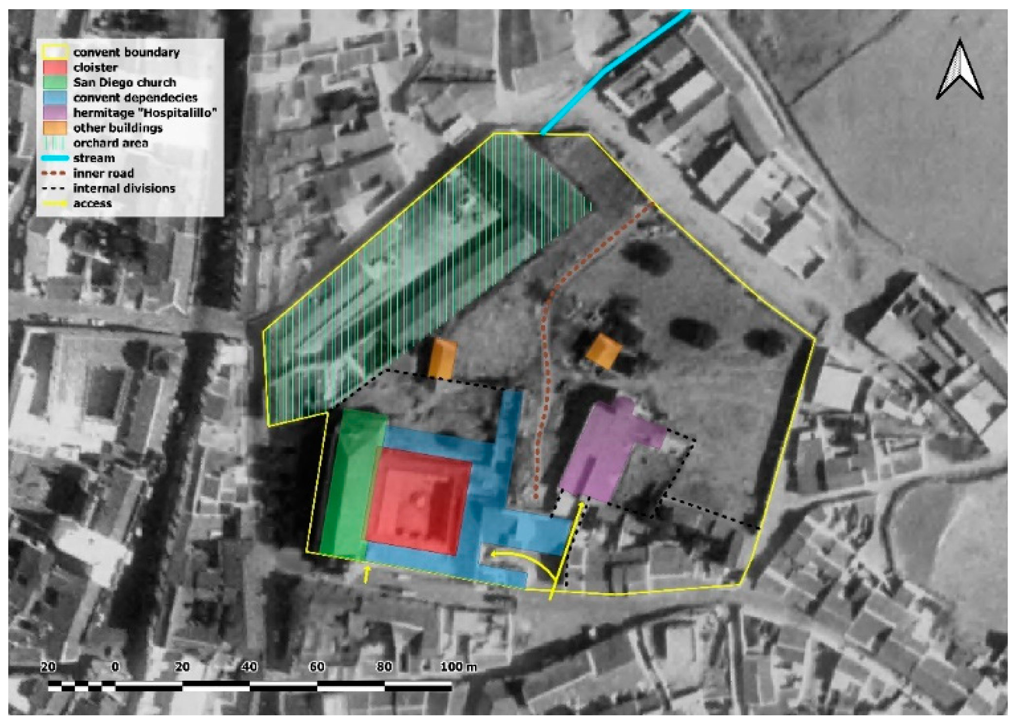
1. Introduction
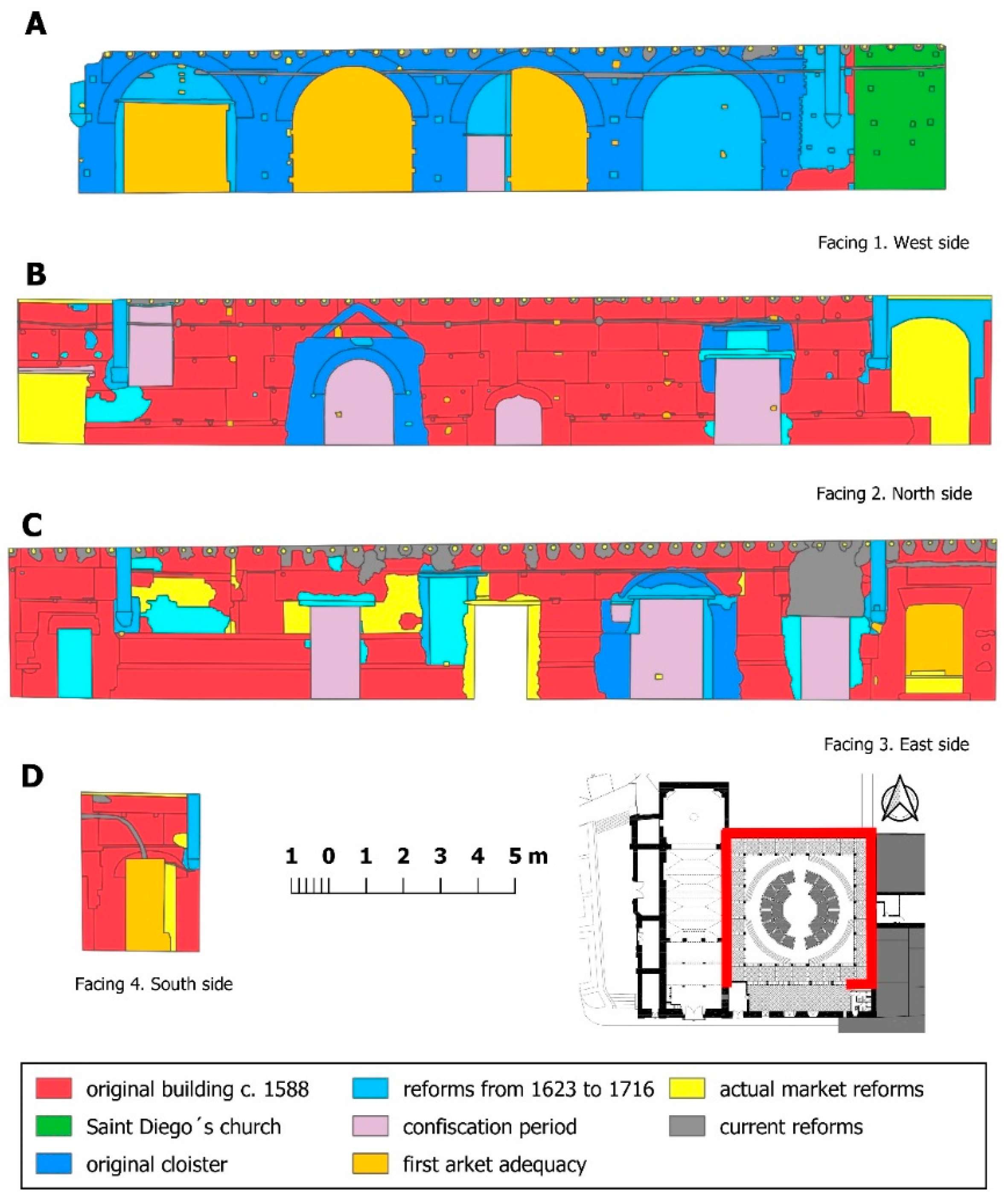
- Original building—construction of the original cloister: circa 1588;
- First reform of the cloister—first remodeling encouraged by the construction of San Diego’s Church attached to its flank W: from 1623 to 1716 (ending year);
- Final reform of the cloister—second remodeling because of the addition of a porticoed gallery with arcades: during the 17th century (in this phase, a subphase can be identified, probably from the 18th century with light reforms);
- Reforms during the Spanish confiscation period—third remodeling due to the fact of the Spanish confiscations and the implementation of a schnapps factory in its environment: from 1835 and during the rest of the 19th century.
- First transformation for the Municipal Food Market’s adequacy—reforms for the implantation of the municipal market: circa 1940;
- Second transformation for the Municipal Food Market’s adequacy—reforms for a new adequacy for the usage as a market: approximately in the last decade of the 20th century;
- Current work—works on improving that were being carried out in the facings as of the date of the fieldwork for this study, July 2019.
2. Materials and Methods
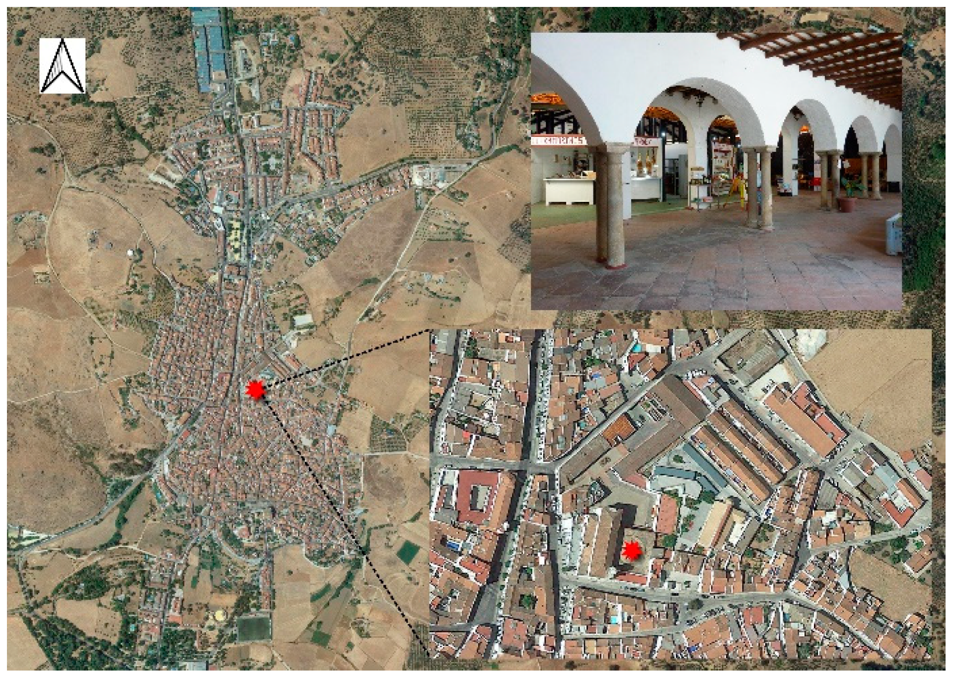
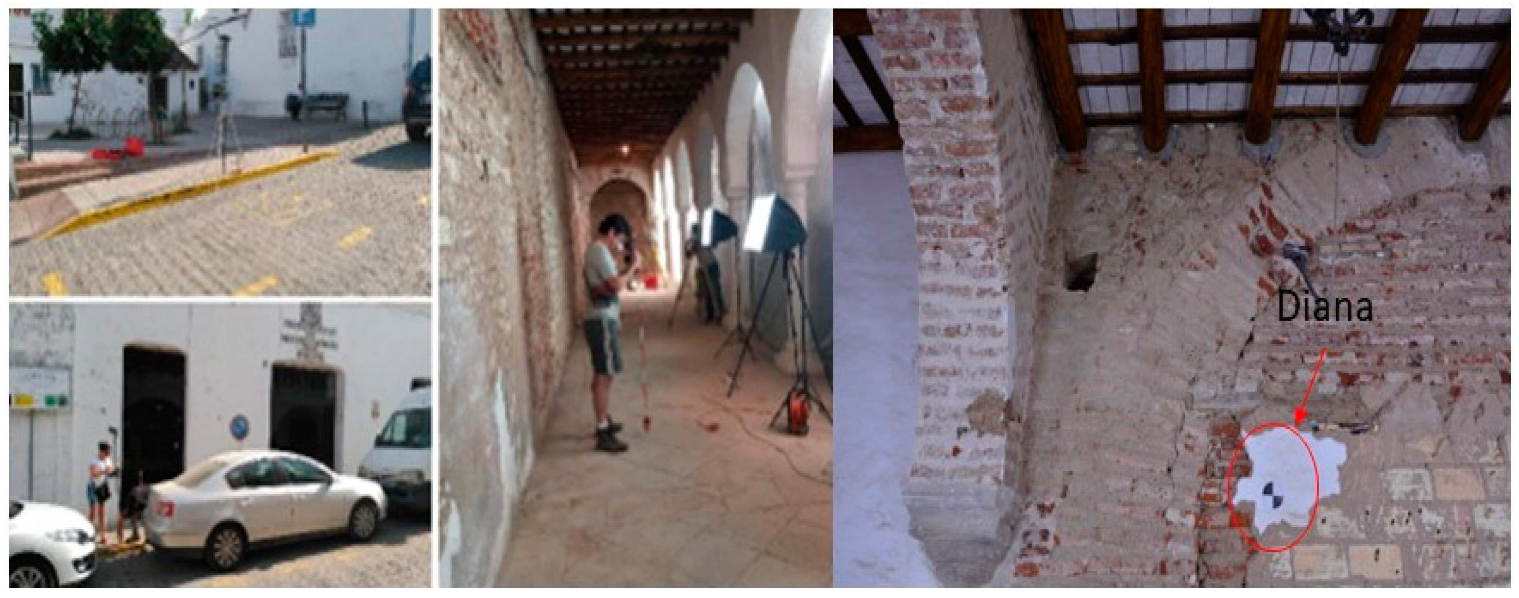
2.1. Materials
2.2. Methods
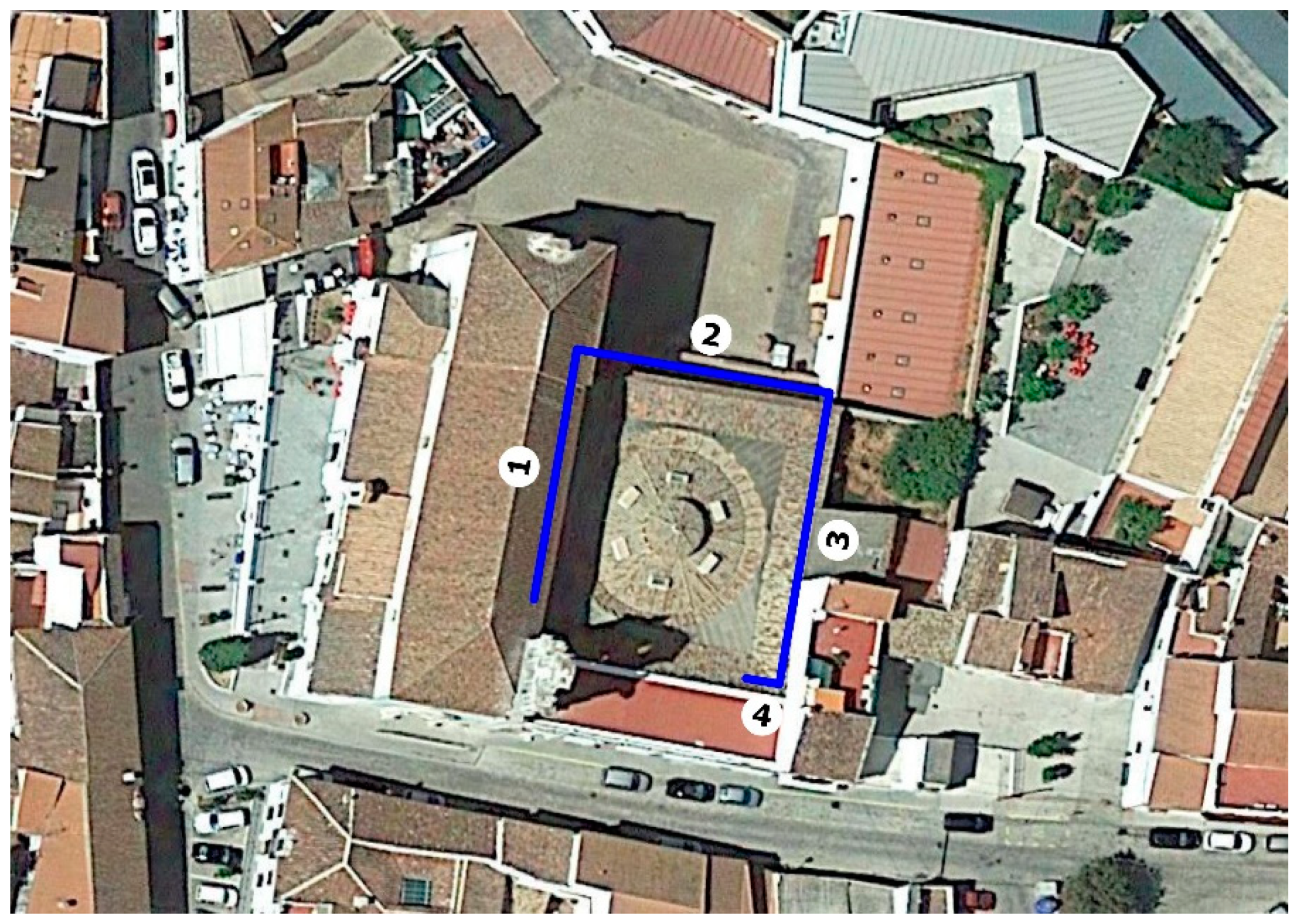
2.2.1. Coordinate System Implantation
- -
- Points measured to generate the GNSS positioning network: 5 points, all outdoors;
- -
- Points measured with the TCR705 inside the enclosure on the ground: 11 in total measured on mini prism;
- -
- Points measured with the TCR705 on targets placed on the wall: 19 points, which would be used for adjustment in photogrammetry [11].
- -
- Points measured with the TCR705 on scanner targets, GZT21 on a tripod pole: 7 points taken. [12].
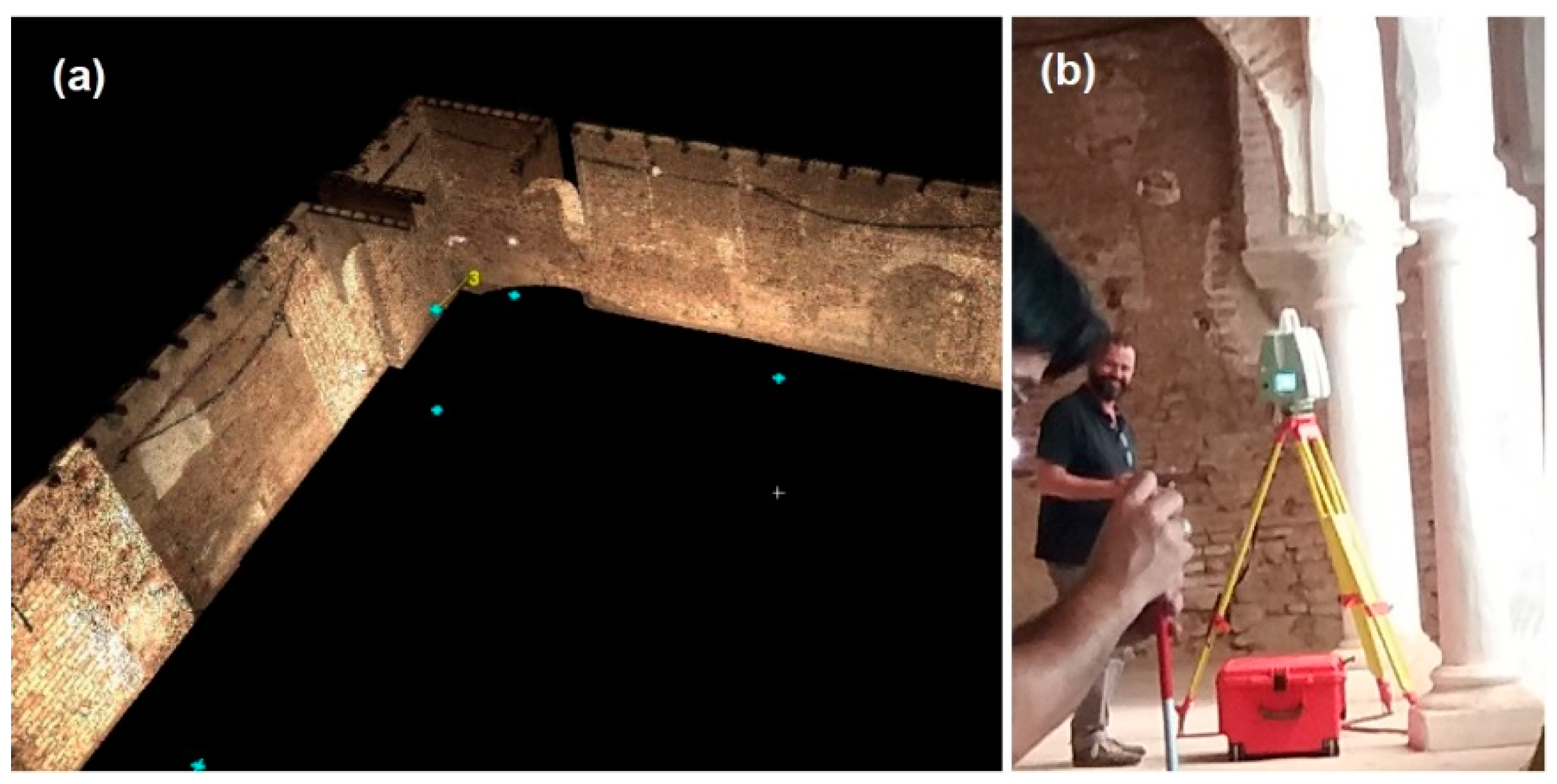
2.2.2. Laser Scanner Method
2.2.3. Photogrammetric Method
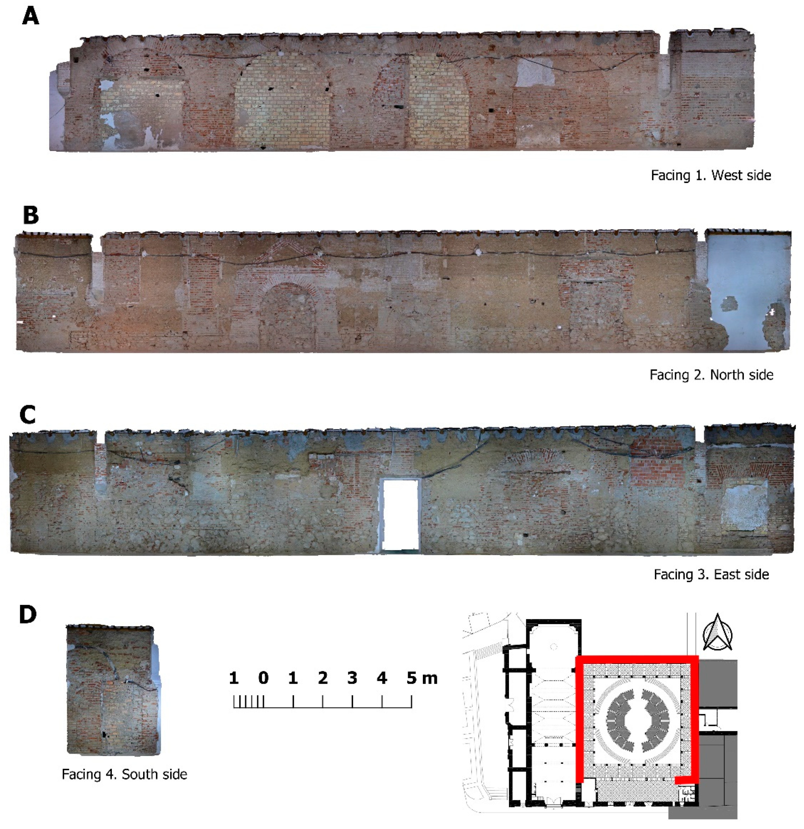
2.2.4. TLS Results and Photogrammetry
- -
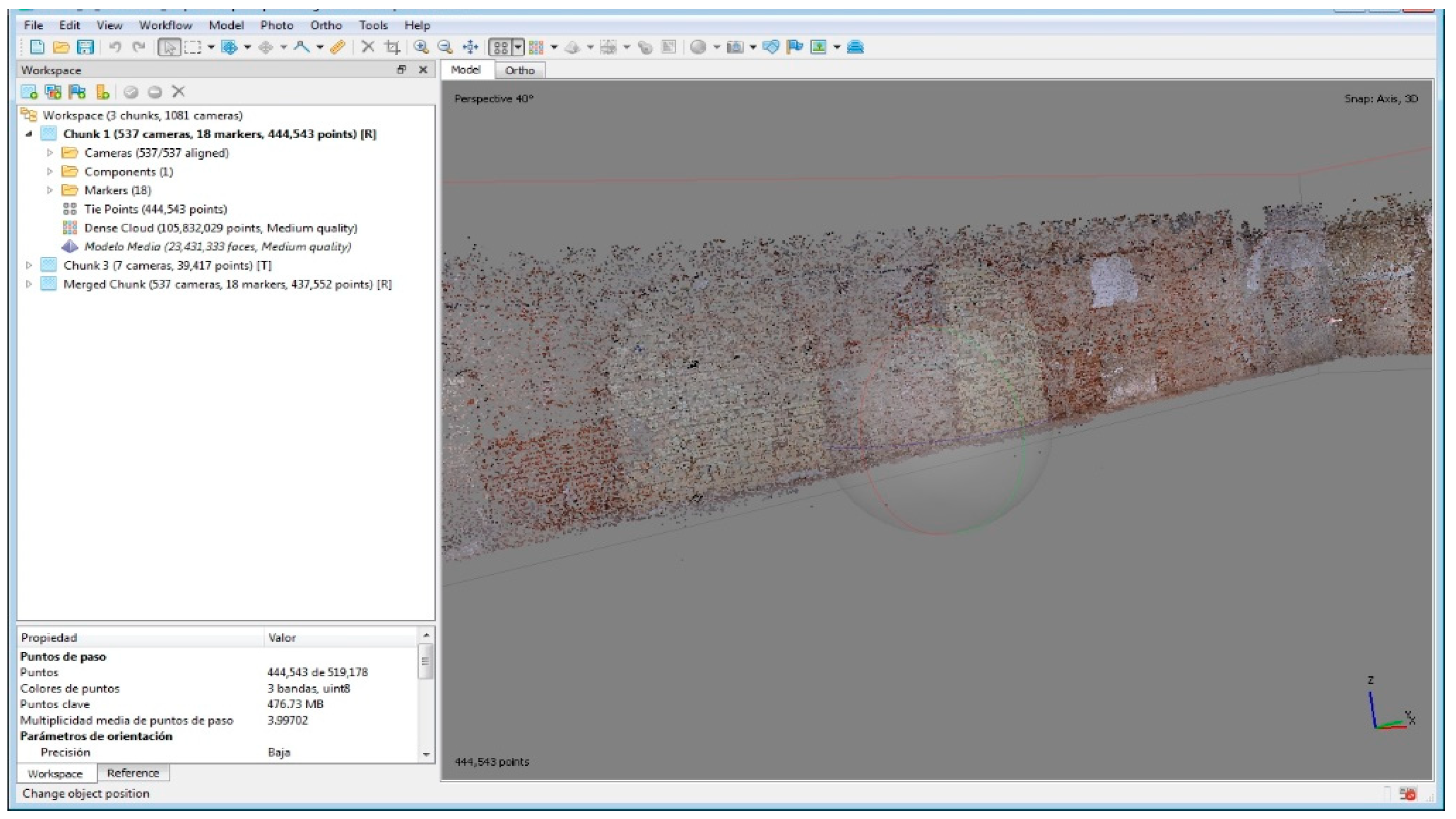
- With the TLS technique, more than 40,000,000 points were obtained. All of them are part of a dense cloud of points in 3D and with RGB (Red–Green–Blue) (Figure 3a). The cloud of points is the result of the union of several scanning taken from different positions and that are integrated into a single geometry thanks to the field measurement of the HDS targets that were previously surveyed with the total station. After making the register process, employing Leica’s CYCLONE program and integrating the partial clouds of points, a joint cloud was obtained, scaled and precisely georeferenced.
- -
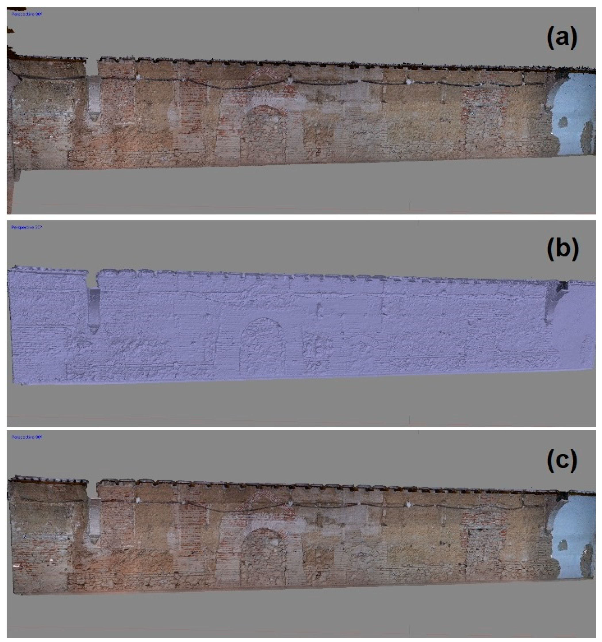
- With the photogrammetry technique, a dense cloud of points of more than 108,000,000 points was obtained, as well as a 3D mesh of more than 21,000,000 polygons (Figure 5b,c).
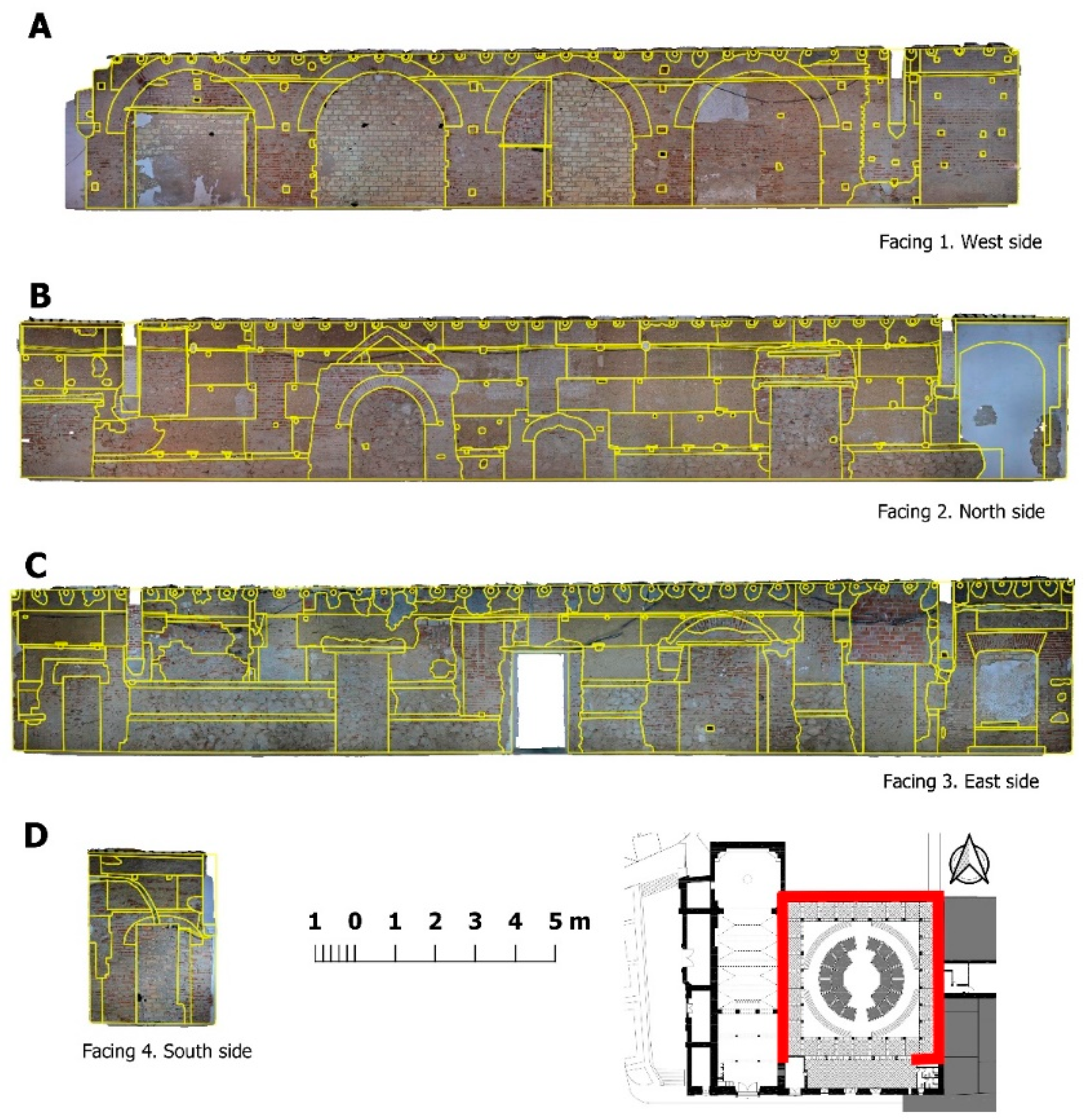
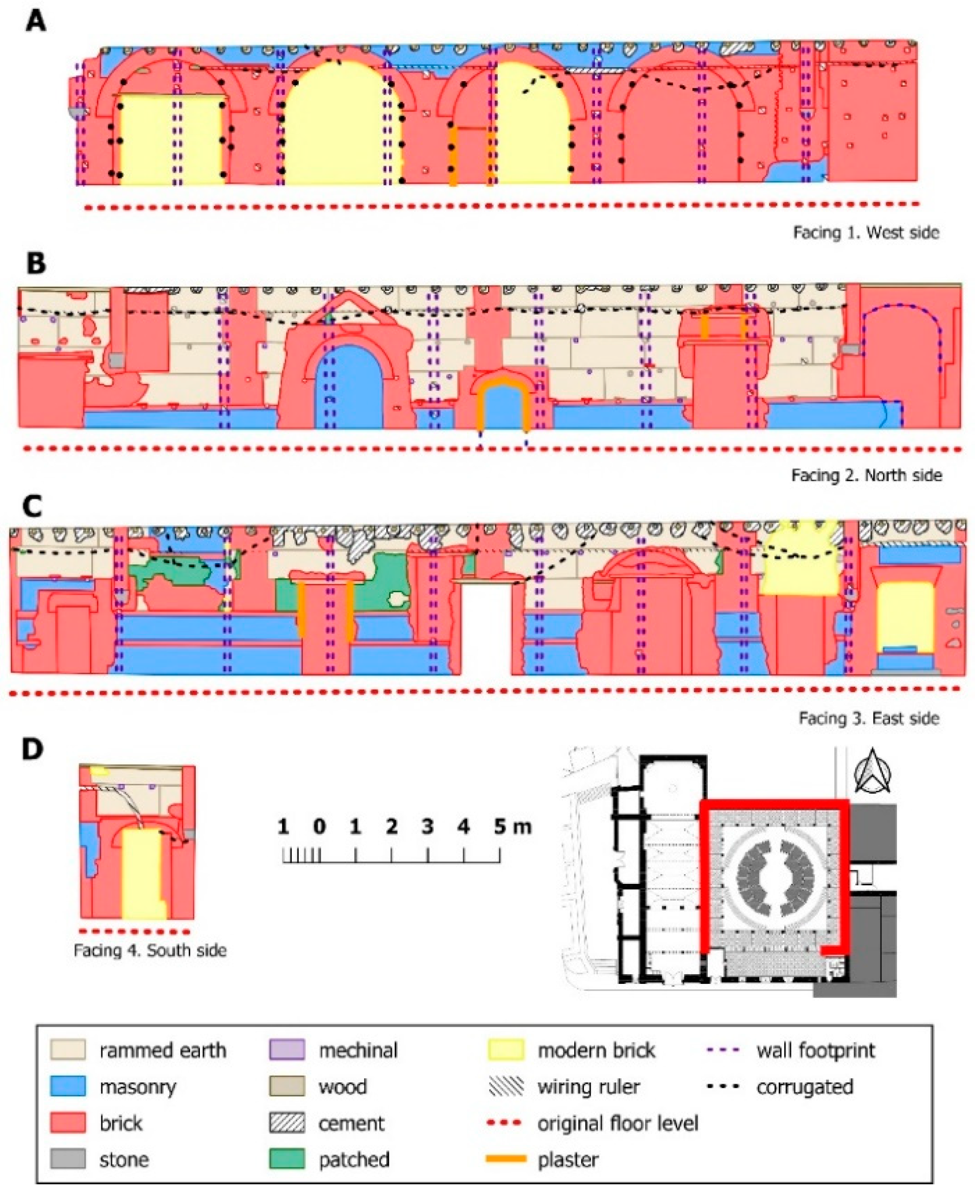
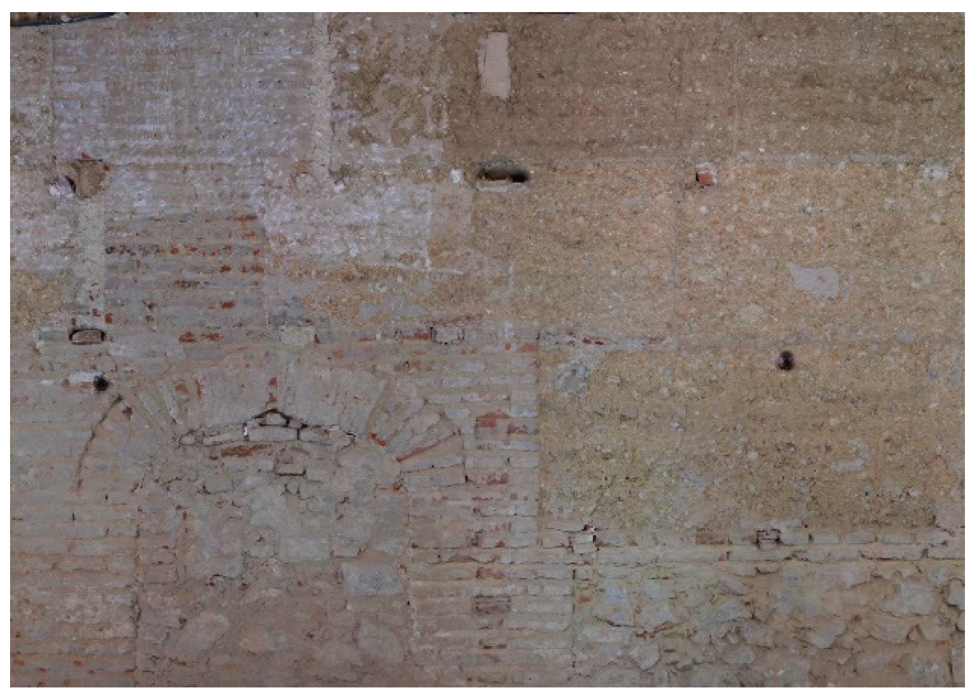
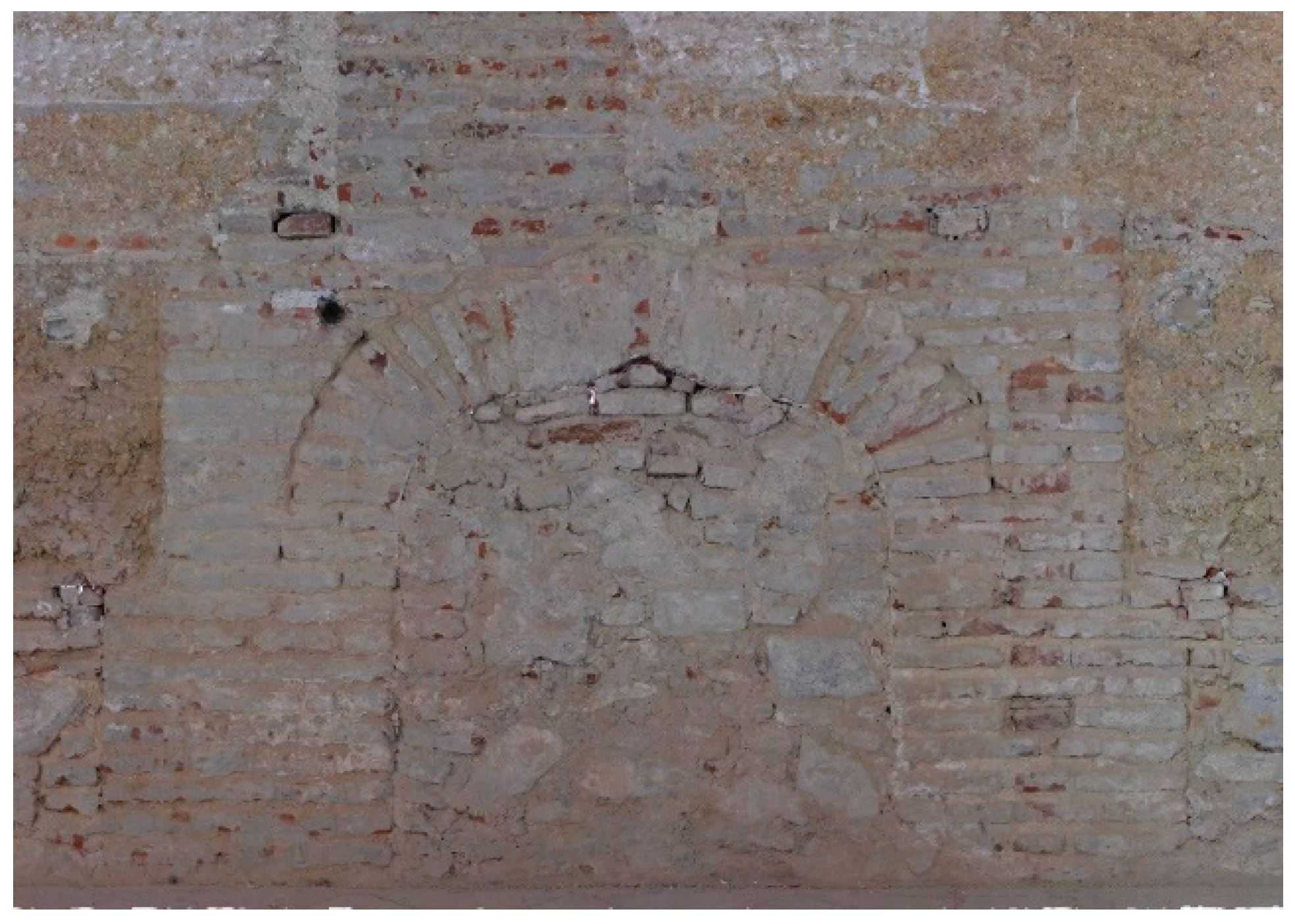
2.3. Wall Face Analysis
- -
- The concept of transformation of the structure, i.e., of the changes, added and modifications that, at an archaeological level, had occurred, which model variations in the uses;
- -
- The concept of archaeological sequence occurred over itself, understanding this as the evolution that the structure displays through the documented stratigraphic sequence, defined by each of the identifiable elements in the building structure and its spatiotemporal arrangement, from its construction until the present time or until its definitive amortization.;
- -
- The concept of a historical process—that goes further from its physical nature and that requires its environment—refers to both the level of the edification and the historical moment in which each structure or its parts are framed.
2.3.1. Building Components Definition
2.3.2. Assignation of Materials to the Components
2.3.3. Establishment of Usage and Components’ Function
2.3.4. Ascription to the Phases of the Archaeological Sequence Observed
2.3.5. Determination of Phases and Historical Contexts
3. Results
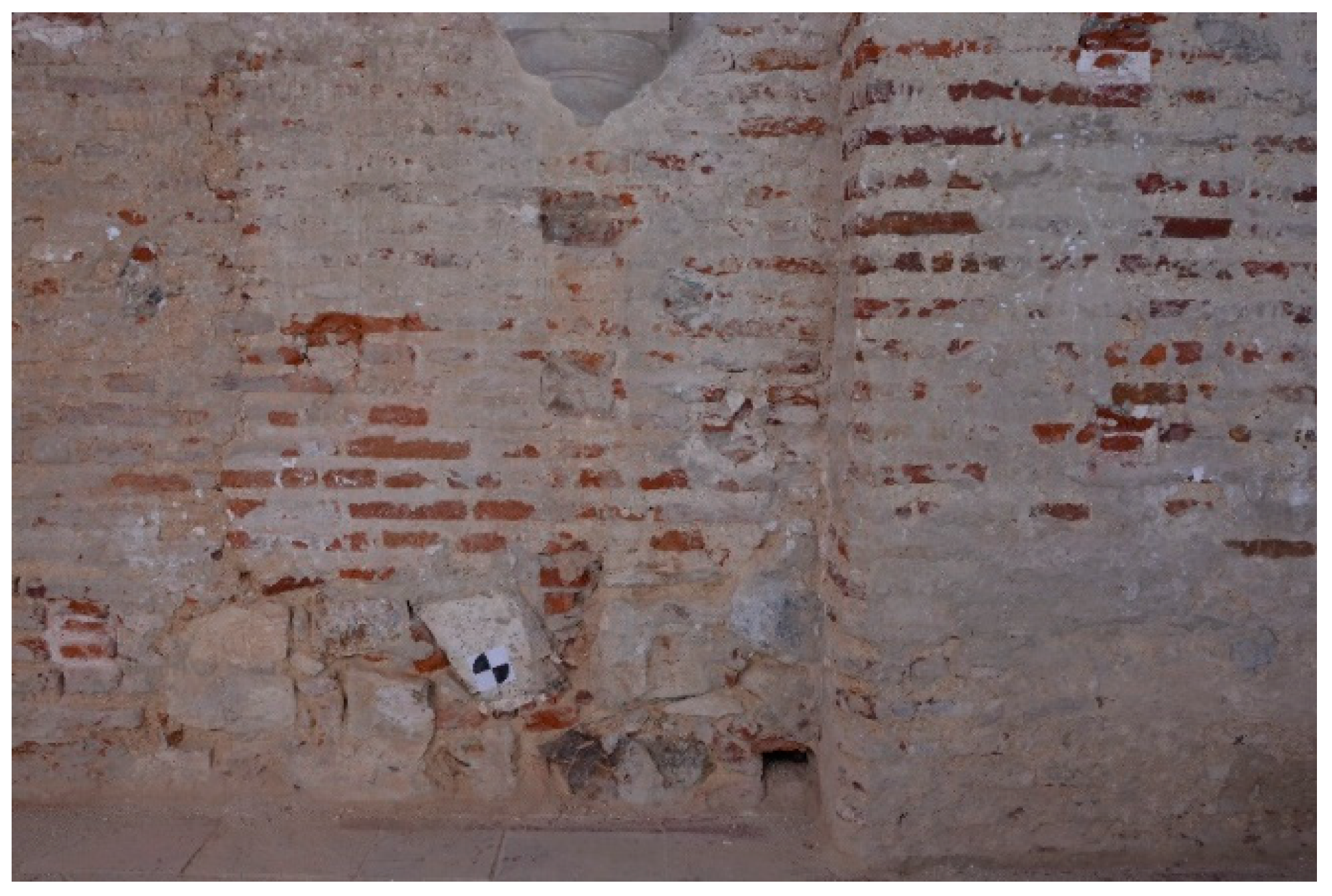
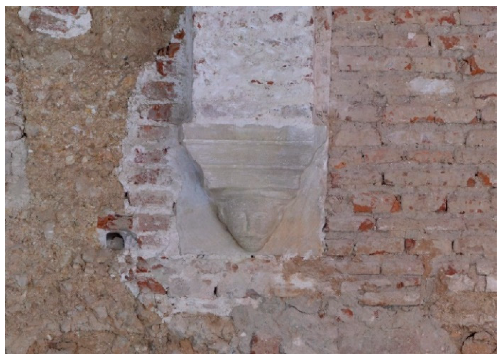
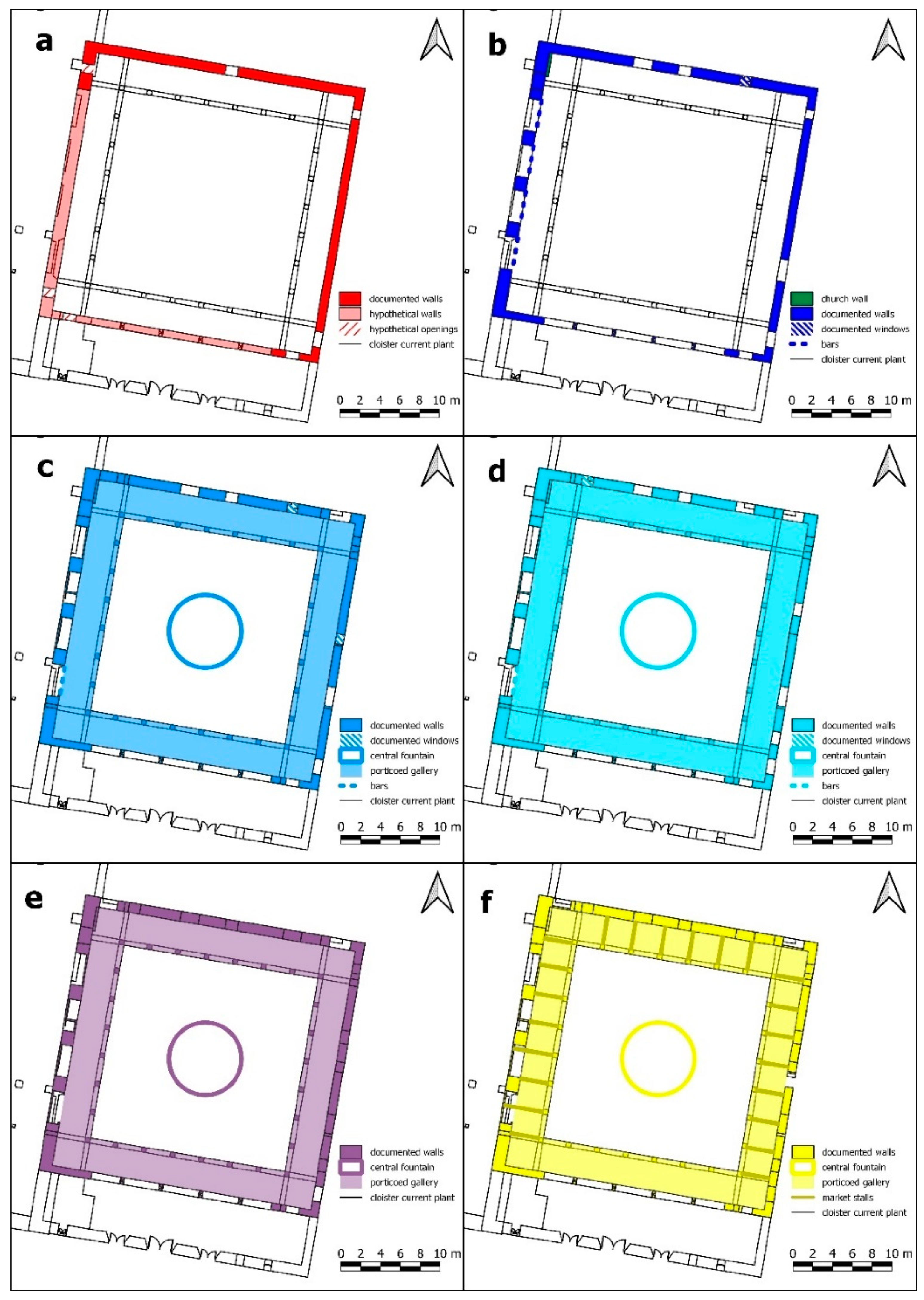
3.1. Original Building—Construction of the Original Cloister: Circa 1588
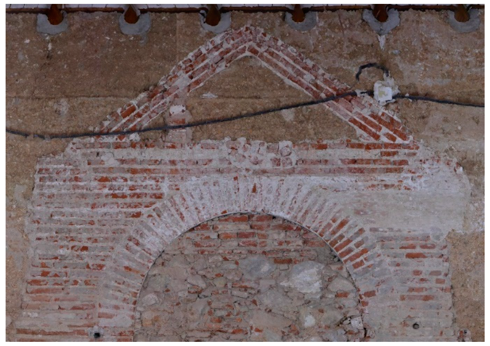
3.2. First Reform of the Cloister—First Remodeling Encouraged by the Construction of San Diego’s Church: Early 17th Century
3.3. Final Reform of the Cloister—Second Remodeling during the 17th Century and the First Third of the 18th Century
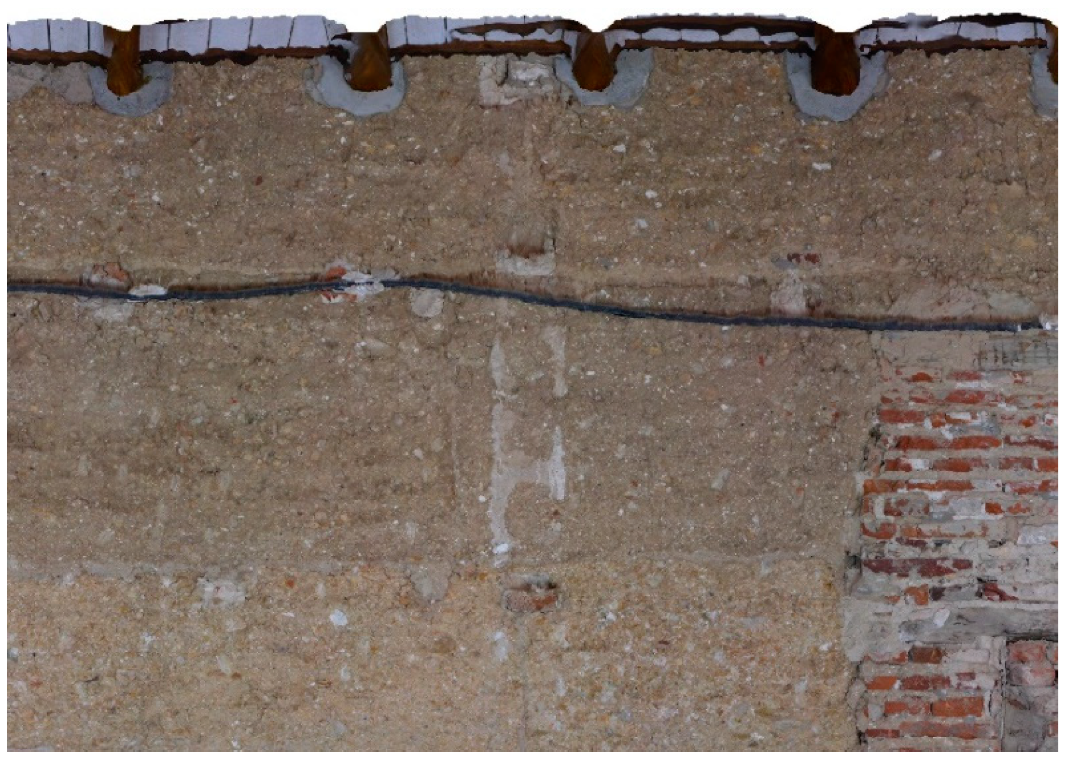
3.4. Reforms during the Spanish Confiscation Period: From 1835 and during the Rest of the 19th Century
3.5. Transformations for the Market’s Adequacy: Circa 1940 and the Last Decade of the 20th Century
4. Discussion
Evolution of the Cloister in the Cloister’s Context
5. Conclusions
Supplementary Materials
Author Contributions
Funding
Data Availability Statement
Acknowledgments
Conflicts of Interest
References
- Hernández, S. El ex—Convento de San Francisco, vulgo de los Diezmos. Rev. De Cazalla 2000, 1–7. [Google Scholar]
- Hernández, S. La Orden Tercera en la provincia franciscana de los Ángeles. In El Franciscanismo en Andalucía: La Orden Tercera Seglar; Peláez del Rosal, M., Ed.; Asociación Hispánica de Estudios Franciscanos: Priego de Córdoba, Spain, 2006; pp. 295–304. [Google Scholar]
- Hernández, S. La provincia franciscana de los Ángeles y sus conventos de la sierra norte Sevillena. In Cuatro Siglos de Presencia de los Franciscanos en Estepa; Aranda, J., Ed.; Ayuntamiento de Estepa: Estepa, Spain, 2007; pp. 393–420. [Google Scholar]
- Georgopoulos, A. 3D virtual reconstruction of archaeological monuments. Mediterr. Archaeol. Archaeom. 2014, 14, 155–164. [Google Scholar]
- Marín-Buzón, C.; Pérez-Romero, A.; López-Castro, J.L.; Ben Jerbania, I.; Manzano-Agugliaro, F. Photogrammetry as a New Scientific Tool in Archaeology: Worldwide Research Trends. Sustainability 2021, 13, 5319. [Google Scholar] [CrossRef]
- Mañana-Borrazás, P.; Blanco-Rotea, R. Using 3D Laser Scanning in Archaeology of Architecture. In Proceedings of the III Seminário Internacional ArcHC_3D. Conservaçao, Restauroe Rehabilitaçao: Metodologias de Levantamento, Lisboa, Portugal, 31 November 2011. [Google Scholar]
- Hatzopoulos, J.N.; Stefanakis, D.; Georgopoulos, A.; Tapinaki, S.; Volonakis, S.; Volonakis, P.; Liritzis, I. use of various surveying technologies to 3d digital mapping and modelling of cultural heritage structures for maintenance and restoration purposes: The tholos in delphi, Greece. Mediterr. Archaeol. Archaeom. 2017, 17, 311–336. [Google Scholar] [CrossRef]
- Alby, E. Ten years of digital documentation of the archaeological site of the Monastery of Saint Hilarion in Tell Umm el-Amr, Gaza Strip. Int. Arch. Photogramm. Remote Sens. Spatial Inf. Sci. 2021, XLVI-M-1-2021, 17–21. [Google Scholar] [CrossRef]
- Verhoeven, G.; Doneus, M.; Briese, C.; Vermeulen, F. Mapping by matching: A computer vision-based approach to fast and accurate georeferencing of archaeological aerial photographs. J. Archaeol. Sci. 2012, 39, 2060–2070. [Google Scholar] [CrossRef]
- Marín-Buzón, C.; Pérez-Romero, A.; Tucci-Álvarez, F.; Manzano-Agugliaro, F. Assessing the orange tree crown volumes using google maps as a low-cost photogrammetric alternative. Agronomy 2020, 10, 893. [Google Scholar] [CrossRef]
- Villanueva, J.K.S.; Blanco, A.C. Optimization of ground control point (GCP) configuration for unmanned aerial vehicle (UAV) survey using structure from motion (SFM). Int. Arch. Photogramm. Remote Sens. Spat. Inf. Sci. 2019, 42, 167–174. [Google Scholar] [CrossRef]
- Oniga, V.-E.; Breaban, A.-I.; Pfeifer, N.; Chirila, C. Determining the suitable number of ground control points for UAS images georeferencing by varying number and spatial distribution. Remote Sens. 2020, 12, 876. [Google Scholar] [CrossRef]
- Sánchez Díaz, F.J.; Torrecillas Lozano, C. Diseño de la red andaluza de posicionamiento. Mapping 2004, 94, 6–14. [Google Scholar]
- Truong-Hong, L.; Gharibi, H.; Garg, H.; Lennon, D. Equipment considerations for terrestrial laser scanning for civil engineering in urban areas. J. Sci. Res. Rep. 2014, 3, 2002–2014. [Google Scholar] [CrossRef] [PubMed]
- Cabo, C.; Del Pozo, S.; Rodríguez-Gonzálvez, P.; Ordóñez, C.; Aguilera, S.D.P. Comparing terrestrial laser scanning (TLS) and wearable laser scanning (WLS) for individual tree modeling at plot level. Remote Sens. 2018, 10, 540. [Google Scholar] [CrossRef]
- Large, A.R.; Heritage, G.L. Laser scanning–Evolution of the discipline. In Laser Scanning for the Environmental Sciences; WileyBlackwell: Oxford, UK, 2009; pp. 1–20. [Google Scholar]
- Salaun, Y.; Marlet, R.; Monasse, P. Line-Based Robust SfM with Little Image Overlap. In Proceedings of the 2017 International Conference on 3D Vision (3DV), Qingdao, China, 10–12 October 2017; pp. 195–204. [Google Scholar]
- Fabris, M.; Achilli, V.; Artese, G.; Bragagnolo, D.; Menin, A. High resolution survey of phaistos palace (Crete) by Tls and terrestrial photogrammetry. Int. Arch. Photogramm. Remote Sens. Spat. Inf. Sci. 2012, 39, B5. [Google Scholar] [CrossRef]
- Peña-Villasenín, S.; Gil-Docampo, M.; Ortiz-Sanz, J. Professional SfM and TLS vs a simple SfM photogrammetry for 3D modelling of rock art and radiance scaling shading in engraving detection. J. Cult. Herit. 2018, 37, 238–246. [Google Scholar] [CrossRef]
- Marín-Buzón, C.; Pérez-Romero, A.M.; León-Bonillo, M.J.; Martínez-Álvarez, R.; Mejías-García, J.C.; Manzano-Agugliaro, F. Photogrammetry (SfM) vs. Terrestrial Laser Scanning (TLS) for Archaeological Excavations: Mosaic of Cantillana (Spain) as a Case Study. Appl. Sci. 2021, 11, 11994. [Google Scholar] [CrossRef]
- Khalloufi, H.; Azough, A.; Ennahnahi, N.; Kaghat, F.Z. Low-cost terrestrial photogrammetry for 3d modeling of historic sites: A case study of the marinids’ royal necropolis city of fez, morocco. Mediterr. Archaeol. Archaeom. 2020, 20, 257–272. [Google Scholar] [CrossRef]
- Altuntas, C.; Hezer, S.; Kırlı, S. Image based methods for surveying heritage of masonry arch bridge with the example of dokuzunhan in konya, turkey. Scient. Cult. 2017, 3, 13–20. [Google Scholar] [CrossRef]
- Harris, E.C. Principles of Archaeological Stratigraphy; Academic Press: London, UK, 1979. [Google Scholar] [CrossRef]
- Carandini, A. Storie Dalla Terra. Manuale Dello Scavo Archeologico; De Donato: Italia, Bari, 1981. [Google Scholar]
- Mannoni, T. Archeologia Dell’architettura. Not. Di Archeol. 1990, 54, 28–29. [Google Scholar]
- Mannoni, T. Metodi di datazioni dell´edilizia storica. Archeol. Mediev. 1984, XI, 396–404. [Google Scholar]
- Fossati, S. La datazione dei matoni: Una proposta di método. Archeol. Mediev. 1985, XII, 731–736. [Google Scholar]
- Bonelli, R. Archeologia stratificata e Storia dell´Architettura. Architettura. Stor. E Doc. 1986, 2, 5–10. [Google Scholar]
- Doglioni, F. La ricerca sulle strutture edilizie tra aecheologia stratigrafica e restauro architettonico. In Archeologia e Restauro dei Monumenti; Francovich, R., Parenti, R., Eds.; All’Insegna del Giglio: Firenze, Italia, 1988; pp. 223–247. [Google Scholar]
- Parenti, R. La tecniche di documentazione per una lettura stratigrafica dell´elevato. In Archeologia e Restauro dei Monumenti; Francovich, R., Parenti, R., Eds.; All’Insegna del Giglio: Firenze, Italia, 1988; pp. 249–279. [Google Scholar]
- Pringent, D.; Hunot, J.Y. Archéologie et monuments historiques. Doss. D’archeologie 2000, 250, 72–75. [Google Scholar]
- Esquieu, Y. L’archeologie du bâti en France. Archeol. Dell’architettura 1997, 2, 133–140. [Google Scholar]
- Journot, F. Archéologie du Bâti. In La Construction en Pierre; Bessac, J.C., Ed.; Editions Errance: Paris, Francia, 1999; pp. 133–163. [Google Scholar]
- Bedal, K. Historische Hausforschung: Eine Einführung in Arbeitsweise, Begriffe und Literatur; Fränkisches Freilichtmuseum: Bad Windsheim, Germany, 1993. [Google Scholar]
- Kimpel, D. La actividad constructiva en la Edad Media: Estructura y evolución. In Talleres de Arquitectura en la Edad Media; Cassanelli, R., Ed.; Moleiro Editor: Barcelona, Spain, 1995; pp. 11–50. [Google Scholar]
- Wood, J. Building Archaeology. Applications in Practice; Oxbow Books: Oxford, UK, 1994. [Google Scholar]
- Morriss, R.K. The Archaeology of Buildings; Tempus: Stroud, UK, 2000. [Google Scholar]
- Roskams, S. Interpreting Stratigraphy. Site Evaluation, Recording Procedures and Stratigraphic Analysis. Papers Presented to the Interpreting Stratigraphy Conferences 1993–1997; British Archaeological Reports, International Series 910; Archaeopress: Oxford, UK, 2000. [Google Scholar]
- Tabales, M.A. Sistema de Análisis Arqueológico de Edificios Históricos; Servicio de Publicaciones Universidad de Sevilla: Seville, Spain, 2002. [Google Scholar]
- Tabales, M.A. Arqueología y rehabilitación en Sevilla. Desarrollo metodológico y práctico. Arqueol. De La Arquit. 2002, 1, 193–206. [Google Scholar] [CrossRef]
- Tabales, M.A. Análisis arqueológico de paramentos. Algunas reflexiones referentes a las últimas actividades sobre inmuebles históricos en la ciudad de Sevilla. In Actas del V Congreso de Arqueología Medieval Española; Consejería de Educación y Cultura: Valladolid, Spain, 2001; pp. 319–328. [Google Scholar]
- Tabales, M.A. La arqueología en edificios históricos. PH Boletín 1997, 20, 65–81. [Google Scholar]
- Tabales, M.A. La investigación arqueológica en edificios históricos: Metodología y experiencias. El Alcázar de Sevilla. In Arqueología Aplicada al Estudio e Interpretación de Edificios Históricos; Martín, C., de Vega, E., Eds.; Ministerio de Cultura, Subdirección General de Publicaciones, Información y Documentación: Madrid, Spain, 2010; pp. 159–178. [Google Scholar]
- Caballero, L. La intervención arquitectónica analizada desde la intervención arqueológica. In Actas del VII Curso Sobre la Intervención en el Patrimonio Arquitectónico. Vic 1984; COAC: Barcelona, Spain, 1985; pp. 27–32. [Google Scholar]
- Caballero, L. Una experiencia en Arqueología de la Arquitectura. Arqueol. De La Arquit. 2004, 3, 127–142. [Google Scholar] [CrossRef]
- González, A. Recerca i Disseny. El Monument com a Document Historic i Com Objecte Arquitectonic Viu; Diputación de Barcelona: Barcelona, Spain, 1985. [Google Scholar]
- González, A. A la recerca de la restauració objectiva. In Com i per a qui Restaurem. Objectius, Mètodes i Difusió de Restauració Monumental (Memoria 1985–1989); Lacuesta, R., López, A., González, A., Eds.; Diputación de Barceona: Barcelona, Spain, 1990. [Google Scholar]
- González, A. Estudio, uso y abuso del patrimonio arquitectónico. In Monumentos y Proyecto. Jornadas Sobre Criterios de Intervención en el Patrimonio Arquitectónico; Baquedano, E., Ed.; Ministerio de Cultura: Madrid, Spain, 1990. [Google Scholar]
- López, A. Consideraciones metodológicas sobre la actuación del Servicio de Catalogación y Conservación de Monumentos en el campo de la investigación arqueológica. In Actas del VII Curso Sobre la Intervención en el Patrimonio Arquitectónico. Vic 1984; COAC: Barcelona, Spain, 1985. [Google Scholar]
- López, A. Set anys d´investigació arqueológica del patrimoni arquitectonic. In Com i per a qui Restaurem. Objectius, Mètodes i Difusió de Restauració Monumental (Memoria 1985–1989); Lacuesta, R., López, A., González, A., Eds.; Diputación de Barcelona: Barcelona, Spain, 1990. [Google Scholar]
- Graciani, A.; Tabales, M.A. El tapial en el área Sevillana. Avance cronotipológico estructural. Arqueol. De La Arquit. 2008, 5, 135–158. [Google Scholar] [CrossRef]
- Orthophoto from 1:18,000 Scale Interministerial Analogue Photogrammetric Flight from 1977-83 (Commonly Known as IRYDA), and Black-White Photographic Film. Digitization (Scanning) of Flight Frames at 25 Microns (0.45 m Pixel on the Ground). The Resolution of the Resulting Orthophoto is 0 5 m. Available online: http://www.ideandalucia.es/catalogo/inspire/srv/api/records/bc27815e-b8dc-4c62-8f17-38850455ff9e (accessed on 3 December 2022).
- Doukas, P.; Stamatopoulos, M.I.; Anagnostopoulos, C.-N. Information technology and archaeological excavations: A brief overview. Sci. Cult. 2022, 8, 147–167. [Google Scholar] [CrossRef]


Publisher’s Note: MDPI stays neutral with regard to jurisdictional claims in published maps and institutional affiliations. |
© 2022 by the authors. Licensee MDPI, Basel, Switzerland. This article is an open access article distributed under the terms and conditions of the Creative Commons Attribution (CC BY) license (https://creativecommons.org/licenses/by/4.0/).
Share and Cite
León-Bonillo, M.J.; Mejías-García, J.C.; Martínez-Álvarez, R.; Pérez-Romero, A.M.; León-Ortíz, C.; Marín-Buzón, C. SfM Photogrammetric Techniques Applied in the Building Archaeology Works of the Old Cloister of the Monastery of San Francisco from the 16th Century (Cazalla de la Sierra, Seville). Heritage 2022, 5, 3901-3922. https://doi.org/10.3390/heritage5040201
León-Bonillo MJ, Mejías-García JC, Martínez-Álvarez R, Pérez-Romero AM, León-Ortíz C, Marín-Buzón C. SfM Photogrammetric Techniques Applied in the Building Archaeology Works of the Old Cloister of the Monastery of San Francisco from the 16th Century (Cazalla de la Sierra, Seville). Heritage. 2022; 5(4):3901-3922. https://doi.org/10.3390/heritage5040201
Chicago/Turabian StyleLeón-Bonillo, Manuel José, Juan Carlos Mejías-García, Rubén Martínez-Álvarez, Antonio Miguel Pérez-Romero, Cristina León-Ortíz, and Carmen Marín-Buzón. 2022. "SfM Photogrammetric Techniques Applied in the Building Archaeology Works of the Old Cloister of the Monastery of San Francisco from the 16th Century (Cazalla de la Sierra, Seville)" Heritage 5, no. 4: 3901-3922. https://doi.org/10.3390/heritage5040201
APA StyleLeón-Bonillo, M. J., Mejías-García, J. C., Martínez-Álvarez, R., Pérez-Romero, A. M., León-Ortíz, C., & Marín-Buzón, C. (2022). SfM Photogrammetric Techniques Applied in the Building Archaeology Works of the Old Cloister of the Monastery of San Francisco from the 16th Century (Cazalla de la Sierra, Seville). Heritage, 5(4), 3901-3922. https://doi.org/10.3390/heritage5040201