Abstract
Architectural survey is an evolving field in architecture that has been affected during the past decade by the technological advancements in the field of 3D data acquisition. Some of these technological advancements include long-range laser scanning and photogrammetry. Laser scanning gives us an accurate documentation of the site, even in cases where parts of the building have collapsed. This paper aims to present two case studies of digital documentation through laser scanning and photogrammetry that led to the structural reinforcement and preservation of the first site and to a digital reconstruction and a mixed reality platform for the second site. The first site is an Ottoman Soap factory in Lod, Israel and the second one is an Ottoman Bathhouse in Apollonia, Greece. Both sites dealt with challenges during documentation due to a partial collapse of the building or due to dangerous structural conditions. The digital documentation methodologies allowed for a fast, accurate and comprehensive survey, as well as for a good understanding of the building and the areas which were concealed as a result of the collapse. At the same time, the digital documentation model gave the potential for the cultural heritage (CH) site to become part of the social, economic and cultural local community.
1. Introduction
The aim of this paper is to present the documentation of two monuments from the Ottoman period, one Soap Factory in Israel and one bath in Greece, and to provide, initially, a comprehensive presentation of the visual documentation process that led to 3D digital models of these spaces. Moreover, this paper aspires to make a case on the basis of ongoing research for the potential of emerging technologies, such as mixed reality, to bring CH sites back to life virtually, with the help of applications for hand-held devices, as well as literally by increasing their attractiveness as destinations. The preservation and promotion of CH buildings, especially of those that face threats and are already heavily damaged, starts from capturing and rendering their existing state. This may safeguard them from further deterioration in the sense that visual records can foster and streamline future interventions that aim to reverse recent damage. Furthermore, this process may facilitate actual reconstructions of parts of the building to secure its structural stability or enhance its appeal by moving closer to its original state. However, these interventions are often complex and may raise issues on the site’s integrity if they become intrusive and extensive. This paper puts emphasis on virtual reconstructions that offer visitors historically accurate, immersive and informative cultural experiences through easy-to-use and readily available tools that they can enjoy on their own hand-held devices. These are foregrounded as non-intrusive, easy to employ strategies that can ultimately bolster the locality as a destination and thereby allow such sites to become pivotal for local economies and stakeholders. Therefore, local communities, socio-economic ecosystems, as well as authorities will have vested interests in ensuring the site’s preservation. The key to fostering CH sites’ preservation through the provision of MR cultural experiences is the quality, useability and appeal of the applications that undertake the task to represent the past of a site in ways that appeal to the sensibilities of today’s users, who wish to engage with history in innovative and exhilarating ways.
With respect to the structure of this paper, a literature review surveys the practices, methodologies and results of applied research in the field of heritage building preservation with emphasis on instances that pertain to the scale and characteristics of the monuments discussed as case studies afterwards. The first case study, namely that of the site of an Ottoman Soap Factory in Lod, Israel is presented as an example of documenting a site with cutting-edge technology, that served as a basis for the physical preservation and has the potential for future development in Augmented Reality. Furthermore, the second case study of a similar scale and style building, albeit one with a different function, is presented: an Ottoman bath in Apollonia, Greece. In this case, the documentation process that has similarities with the previous example is given less attention while the use of the data acquired to feed a mixed reality application is foregrounded. The application is developed in the context of the MeginMode research project and aims to provide tools that enable visitors to explore the site’s past in interactive and customizable ways on their smartphones or tablets. Lastly, the conclusions and discussion section, based on the research presented, unfolds the arguments in favor of a comprehensive multi-pronged approach that taps into the potential of digital and emerging technologies as fulcrums for CH preservation, audience engagement and the encouragement of stakeholders’ involvement.
2. Literature Review
Nowadays, the digital tools in our availability are allowing for a fast, accurate and comprehensive survey and mainly 3D documentation [1] of a cultural heritage site that can transform, enrich and enhance the cultural experience. Digital methods of documentation, such as photogrammetry and laser scanning, combined with emerging technologies such as mixed reality can be the means to achieve this goal. The mapping, the reconstruction and the revival of virtual worlds can bring monuments, people, artifacts, procedures and historical events to life. Innovative interaction methods and techniques in combination with new and affordable head-mounted displays (HMDs) for immersive VR based on PCs or mobile devices, such as Oculus Rift and HTC Vive [2], made interactive visualizations of previously unexplored virtual and real-world combinations possible [3].
During the past two decades, a lot of research has been dedicated to exploring how digital tools can provide substantial improvements in the documentation of heritage and how they can contribute to reviving, preserving and reconstructing heritage sites or objects. In 2015, the four-year research project “INCEPTION—Inclusive Cultural Heritage in Europe through 3D Seman-tic Modelling”, funded by EC within the Program Horizon 2020, sought to find the balance between effective user experiences of CH via digital tools and virtual representations, and the enrichment of scientific knowledge. The project explored how to add to CH databases and the ability to access cultural contents and resources, reaching as much of a broad audience as possible by using digital functionalities and applications [4].
Digital technologies can be used to bring destructed CH sites back to life. Such a case study is presented in the case study of the Lichtenwalter schoolhouse in Ohio, USA [5]. The paper presents how a CH site that was destroyed from a fire was documented and then reconstructed virtually with the help of the geometry from the documentation and the texturing from pictures before the fire. Using digital tools for virtual reconstructions of sites that have been long lost has been used extensively for the representation of CH during the past two decades. An example of such a reconstruction is offered by Neolithic Malta [6]. The case study demonstrates how a virtual reconstruction can help with the visualization of a built residential environment and contribute to the understanding and the interpretation of the archaeological findings. The virtual realm gave the possibility to simulate a different hypothesis regarding the archaeological findings. Digital documentations can lead to many types of diverse outcomes that can show the CH site in its existing stage or as a reconstruction and can even help plan a design intervention that combines preservation and architectural renewal. They can lead to architectural drawings of the digital documentation, to 3D models that can be viewed in two-dimensions or experienced in Virtual or Augmented Reality, to a BIM (Building Information Modeling) database or to 3D printing [7].
Digital technologies can play an important role in teaching CH. The virtual visualization of historical sites and objects introduces new possibilities in experiential teaching methodologies in all fields. An example of the diverse courses possible is the VRlab in UCLA’s Sandbox that has numerous virtual reconstructions of important historical sites. Courses that use the virtual environment to teach include obvious courses such as architectural history, urban planning and archaeology, but also other courses in humanities such as roman literature, where students virtually visit the site to read roman scriptures on commemorative arches and on temples [8]. The ‘Digital Education with Cultural Heritage’ MOOC research project took place during 2021 and explored educational tools for combining digital cultural heritage with innovative methodologies in teaching [9]. Another approach is to integrate teaching virtual reconstruction and the 3D modeling of CH with teaching the historical and artistic aspects of the site. A survey on such a methodology showed that students were engaged, and the learning rate of CH topics was favorable to parallel methodologies [10].
Moreover, laser scanning techniques continue to develop, offering unprecedented accuracy, color fidelity and avoidance of shading effects that may interfere with accurate visual documentation. Ceccarelli et al. [11] presented a prototype of laser scanning techniques that can render paintings and inscription on curved surfaces without the limitations of existing camera-based techniques that are affected by the environmental lighting conditions. The specific technological solution is described as ‘Imaging Topological Radar (ITR) technology, developed at the ENEA Research Center of Frascati (RM), as an acquisition method of highly detailed images for 2–3D color digitalization and layering analysis of medium–large targets, independently from the surrounding illumination conditions.’ [11]. The ENEA Research Center has also published research on laser scanning techniques applied to artefacts that were embedded in virtual museum environments [12]. Barille et al. (2022) presented a research project that employed three technologies in combination to survey the exterior and the interior of a small church in Italy; namely, laser scanning, UAVs and ground penetrating radars (as the site included a crypt). The resulting documentations were embedded in a VR application for hand-held devices, offering accurate visualizations of the existing state of the site that could be useful to remote users, etc. Bekele et al., [13] provided a comprehensive literature review that mapped diverse documentation techniques regarding CH, ICT applications communicating/presenting visual material, as well as the corresponding purposes and aims of such technological solutions. Likewise, Nikolakopoulou et al. [14] provided an article with extensive literature review (related work section).
3. The Site of an Ottoman Soap Factory in Lod, Israel
3.1. Historical Information
The case-study site is in Lod in central Israel. The city was founded during the Neolithic period and was continuously inhabited during all the historical periods up to today. During the Roman period, Lod, named at the time “Diospolis”, was considered a crossroad in Israel, as seven imperial roads connected the city with central areas in Israel and the surrounding areas. During the Byzantine period, the city was renamed “Georgopolis” in honor of an important roman officer that was located in the city and contributed to the dissemination of Christianity in the area. In the 7th century the area fell under Muslim rule. For the next several centuries, the city and its surrounding area changed hands between the crusaders and the Mamluks. During the Ottoman period, Lod became an important center for the olive oil industry and all products derived from oil. For this purpose, several stone buildings were built, including the arch building, the El Pe-er Soap Factory (Masbaneh) and others. During the British Mandate, Lod was still considered a major crossroad. A train station was built in the city, for tracks that connected Cairo to Damascus [15]. Just north of Lod, the first airport was built that later on received the name of the first prime minister of Israel, David Ben Gurion. Today, Lod is a diverse city of both Jewish and Arab populations, secular, as well as religious. The state and the municipality are trying to revive the historic center of Lod and aim to preserve several of the buildings from the Ottoman period.
The case study of this documentation was the El Pe-er Soap Factory that is located at the southern side of the Lod farmer’s market, west from the church St. George and the mosques El-Omri (Figure 1).
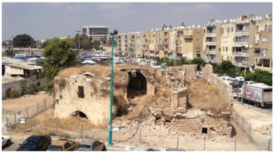
Figure 1.
Ottoman Soap Factory.
The owners of the building were the El Pe-er family. “Masbaneh” in Arabic is a traditional factory that produces soap from olive oil. Farmers would bring their olives to the factory, where they would be separated according to their quality. The olives (including the pits) were placed in a processor that turned them into a creamy mixture. Combined with an alkaline sodium compound and processed under pressure, olive oil was produced. During the first stage of processing, virgin olive oil was produced. During the next stages, a secondary quality of oil was produced, which was used for soap production.
The Soap Factory building is assumed to have been built in the beginning of the 19th century and combines various construction techniques. It can be observed that the flooring has been redone several times. In this building, we encountered a very rare construction technique for this area: the vaults of the building were made with ceramic jars and bottles. Ceramic jars and bottles, which are narrow and long, have strength in compression at the longitudinal axis and therefore their use in construction allows for a low weight and strong vault. However, in the El Pe-er Soap Factory, we encountered the use of thicker jars, whose resilience to pressure is more limited.
At the time of the documentation, the building was in a bad structural condition. Many years without maintenance had left the building with many cracks and displacements, while all the vaults had collapsed into the interiors. Still, we could identify an earlier phase of the building from the meticulous ashlar constructed walls and a subsequent phase, built by a coarser stone that resulted in a lower quality construction. It is presumed that the various construction techniques were covered in plaster. During the British Mandate, the building underwent some reinforcement work using concrete casting. This reinforcement technique is not considered appropriate today. During the past decade, the building was used by squatters that would live in it in primitive conditions. The building was not structurally sound and posed danger for the people entering it. Therefore, the Israel Society of Preservation, together with the city of Lod, requested for a new survey that will serve as the first step in their preservation and reinforcement strategy.
3.2. Materials and Methods
Digital methods in documenting cultural heritage sites are the latest endeavor both in the field of architecture and archaeology. Two main methodologies for digitally documenting the building were used in this project: laser scanning and photogrammetry. Each methodology has its limitations and advantages. This digital survey comprised both methodologies, so that the survey outcome could gain from the advantages of both ways of work. The general geometrical survey was implemented with a long-range laser scanner. The equipment used on site was a C-10 Leica Scan station (Figure 2) that has the capacity to scan up to a 300 m radius.
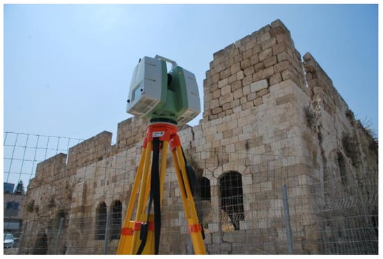
Figure 2.
Leica C-10 Scan station used for laser scanning during the survey.
In addition, photographic imagery was acquired by digital cameras. Photographs were taken so that they had at least a 30% overlap, and subsequently could be combined through cloud computing to create three-dimensional textured meshes of the areas of the site. Each tool has its own strengths and weakness and can contribute to a specific aspect of the documentation. The outcome of the laser scan is a point cloud that gives a raw database of three-dimensional geometrical points, which is highly accurate. In addition, it gives some photographic information of the site that can be used to color the point cloud and give us a realistic preview of the existing geometry (Figure 3).
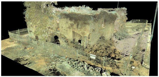
Figure 3.
View into the registered point cloud.
Laser scanning has advanced the quality of architectural documentation and allows for creating comprehensive three-dimensional databases of information. It also makes the data acquisition process very fast and efficient, compared with conventional survey methods. Still, the equipment is costly and bulky, and the photographic imagery is not adequate in quality to produce textures for a virtual model. High quality imagery for texture mapping purposes is best collected through high resolution digital cameras. There are various software and applications that allow for capturing geometry with a series of photographic imagery, and through cloud computing or algorithms within the software, the photographic material can produce three-dimensional textured meshes. While the geometrical information of such meshes is not as accurate as the geometry of a point cloud that was created by laser scanning, the textures of the meshes are photorealistic and high resolution.
3.3. Results
The main challenges in the case study of the Ottoman Soap Factory in Lod were that the survey team had a limited time to execute the survey (3 days on site) and that much of the building was an amorphic pile because of the collapsed roofs. Several areas of the building were not accessible, because they were not structurally sound and were in danger of collapsing. Both challenges were overcome with the involvement of the digital tools.
The site work consisted of scanning and photographing. The building was covered by 8 scan-station locations from the exterior and 13 scan-station locations for the interior (Figure 4).
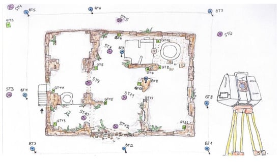
Figure 4.
Sketch of scan stations and targets.
The exterior scans were set on high resolution and the interior scans on medium resolution. Six-inch and three-inch targets were located in the space, which allowed the scans to connect during the registration (Figure 5). In areas that were not accessible to the place targets, building geometry points were used to connect the point clouds.
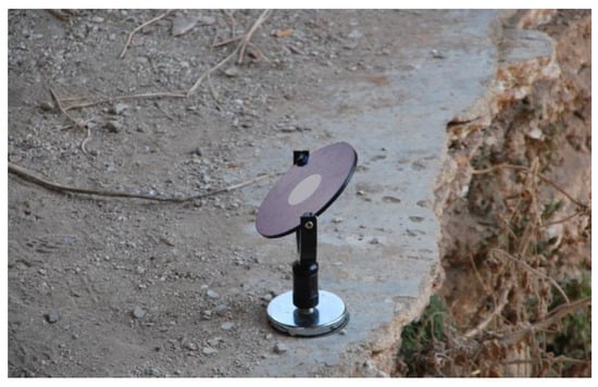
Figure 5.
Target placed in the building.
All targets were named and scanned at a high resolution. For the photogrammetry, a series of digital pictures were taken that were focusing on specific areas/rooms. Later on, the 21 scans were registered into a comprehensive point cloud through Leica’s software Cyclon Geosystems. During the registration process, any problems with the targets were corrected before the registration was finalized. Once a comprehensive point cloud of all the scans was available, coordinate systems were created at the locations where plans, sections or elevations would be produced. Once complete, the point cloud was opened in AutoCAD with the Cloudworks tool bar, and the architectural drawings were drafted. The images extracted from the point cloud can serve as textures for the architectural drawings (Figure 6, Figure 7 and Figure 8).
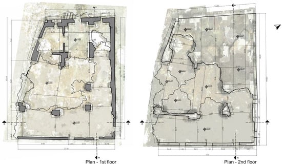
Figure 6.
First floor and roof plan.
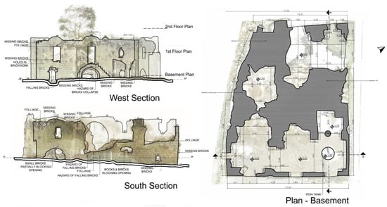
Figure 7.
Elevations and basement plan.
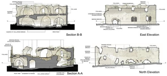
Figure 8.
Sections and elevations.
For the photogrammetry, a series of pictures for a specific area or room were uploaded to the cloud. Cloud computing stitches the images together automatically and gives back a three-dimensional textured mesh. If some pictures were automatically not included, some manual stitching was required (Figure 9).
Figure 9.
Textured three-dimensional mesh derived from photogrammetry.
3.4. The Next Steps
The documentation served as a basis for the preservation of the building. The debris of the collapsed parts of the building were removed and structural reinforcement work took place. The stonework went through restoration and cleaning. Today the site is included in historical tours for the city of Lod and is presented on the websites of the city as one of the Ottoman cultural heritage sites that can be visited.
The municipality is considering creating a 3D database of its cultural heritage sites in the future and may use such documentations to create digital reconstruction models of the sites. Such models will be accessible for the dissemination of knowledge about the site through a medium that can be accessed from afar and is more popular with the younger crowds. An application for smart phones with Augmented Reality is a consideration, so that visitors can access the reconstructions when visiting the site.
4. An Ottoman Bath in Apollonia, Greece
4.1. Historical Information
The second case study is in Nea Apollonia in northern Greece by the southern shore of lake Volvi. The site was built near the ancient city of Apollonia, founded by Chalkidians in 432 BCE. It triggered the Chalkidian War in 382, when asking for help from Sparta against the Chalkidian Federation [16]. The city enjoyed a special status and prosperity during the Ottoman period, with an important bazaar that lasted for many days. In the 16th century, a big bath complex (hamam), a longitudinal inn (khan) and a small mosque, which served mainly as a station post close to the Via Egnatia axis, was built. Near the Ottoman complex, there is the Apostle Paul’s Tribune, in which by the middle of the first century Apostle Paul preached Gospel, faith and salvation. The Ottoman complex is mentioned in the sources by the Venetian officer Gabrielle Cavazza in 1591, as well as by the Ottoman travelers of the 17th c. Katip Çelebi and Evliya Çelebi [17].
The bath (hamam) is a representative Ottoman building of such a typology as it is a bath with a polygonal hot section adorned with niches, which is still preserved in present-day Greece and needs careful and detailed maintenance to stop further collapses and decay of the building materials and mortars. It was built with stones of medium size, bricks and mortar. Its vaults were constructed with bricks and were once covered with tiles. The first space when entering the building is the cold room, a high and square room, covered with a four-sided wooden tiled roof. Next is the intermediate room and finally the hot section. The interior of the hot section, as well as of the intermediate room, are lightened by holes with symmetrical arrangements which are open at the highest parts of the vaults. According to scholars, there are two building phases in the remaining parts of the hamam, the second one possibly dating to the 18th or 19th c.
The building is in a semi-ruined condition: there are some remains from the section with the vaulted hot room, built on hypocausts, and some in the intermediate vaulted room and a small room of secondary use (Figure 10).
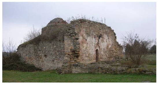
Figure 10.
The Ottoman bath in Nea Apollonia.
4.2. Materials and Methods
The Ottoman bath in Apollonia has been used as a heritage site to develop within the framework of a funded research project, an open-source VR/MR application that would allow visitors to gain an accurate sense of its original state. More specifically, as mentioned in https://merginmode.com/, “MERGIN’ MODE (MixEd Reality and GeoINformatics for MOnument Demonstration), is a Cultural Information System aiming to demonstrate monuments by merging real with virtual, in a Mixed Reality, assisted by Geoinformation technologies” [18]. Specifically, the system makes use of cutting-edge technologies in the field of Geoinformatics for creating digital surface models of a high accuracy, through the usage of unmanned aerial vehicles and worldwide recognized contemporary photogrammetric tools. At the same time, the members of the Project Team exploited the applied research, which was performed for many years and is recognized by the research community as a software prototype for creating custom geospatial worlds [19]. The last simulates the spatial objects related to a monument in a number of overlaid georeferenced vector layers, along with three-dimensional models representing spatial cultural entities able to populate the areas of a digital surface or to move in predefined or dynamically defined paths. Therefore, assisted by the rich historical documentation material, it is possible to represent a monument with its past condition, or to revive events of the past in a perfect virtual world that is combined with the real world, captured by the camera of a smart device, to produce a mixed reality that will enhance the cultural experience of the visitors. Towards immersive experiences, MERGIN’ MODE achieves an interaction between virtual and real objects by implementing the concept of a mixed object via geospatial linking modalities [20].
The MERGIN’ MODE system consists of two major software components: the MERGIN’ MODE Platform (platform.merginmode.com) and the MERGIN’ MODE App (app.merginmode.com). The MERGIN’ MODE Platform acts as an authoring tool for creating virtual scenes with 3D models of the reconstructed monument and other objects of that era of the past. Practically, the MERGIN’ MODE Platform creates virtual geospatial worlds. The term geospatial is critical, since these worlds may appear on the smart device of the visitor of the monument, via the MERGIN’ MODE App (app.merginmode.com), providing immersive virtual/augmented/mixed reality experiences as soon as the visitor/end-user is located in the area of the monument. Thus, the two software components should be able to collaborate, and this is achieved by adopting open data and service technologies.
4.3. Results
4.3.1. Mapping and Reconstruction of the Monument
For demonstration and pilot implementation purposes, in addition to the digital documentation of the monument, 3D scenes were created in which events that took place during the operation of the bath of Apollonia during the 16th century are revived. Initially, a photogrammetric mapping and a 3D reconstruction of the bath exterior (Figure 11 and Figure 12) took place.
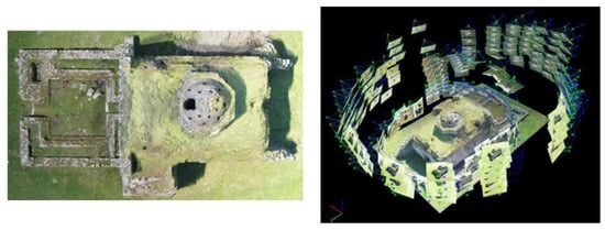
Figure 11.
Aerial photogrammetric mapping.
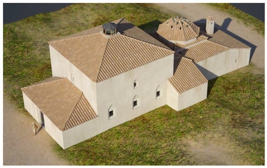
Figure 12.
3D reconstruction of the exterior of the Apollonia Bath.
Subsequently, a mapping of the interior of the bath via laser scanning techniques and a 3D reconstruction of the bath interior was also performed (Figure 13).
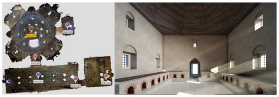
Figure 13.
Laser scanning and 3D reconstruction of the Bath interior.
4.3.2. Creating Immersive Experiences via Extended Realities
The following lines present the functionalities/capabilities of MERGIN’ MODE software components for creating an immersive experience for an end-user/visitor of the CH building area.
- Importing the DSM/DTM of the area, the surface texture and the monument of interest
Digital surface/terrain models (DSM/DTM) determine the basis of which scene unfolds. The slope of each elementary surface also affects the placement of a 3D object on it and the successive changes of the slope in a ground elevation model bring about corresponding changes in the position, orientation and rotation of the object.
- Importing, rotating and scaling other 3D models
The MERGIN’ MODE Platform can import widely adopted formats of 3D models such as gltf and fbx (Figure 14). However, in order for models to be placed over the monument area, they have to be appropriately scaled to the dimensions of the existing world and in some cases have to be rotated in order to have the required orientation, as shown in Figure 15.
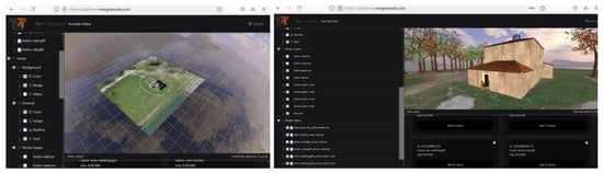
Figure 14.
Importing the digital surface model of the area, 3D models and the 3D reconstruction of the CH building.
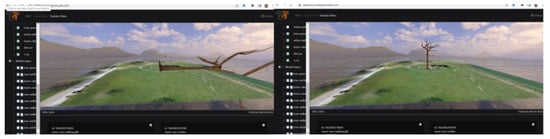
Figure 15.
Scaling and rotating imported 3D models.
- Placing models at selected locations and implementing motion effects
Three-dimensional models may be placed over preloaded and/or user-specified shape geometries of points, lines or polygons. Therefore, one must specify which 3D models are to be placed over which geometries. For example, the user of the MERGIN’ MODE Platform can define a polygon area and relate this area with the type of trees that will populate this area. For implementing motion effects, first, the motion paths have to be specified, which will subsequently be associated with 3D models of potentially moving objects. Motion paths are no different from typical line geometries consisting of a set of points composing the path of the motion of a moving object. As potentially moving objects are considered, those objects that possess a native motion specified by a set of morphs of the object alternate repeatedly throughout the movement. This, in combination with moving on a predefined or user-defined path, leads to the creation of scenes reviving events of the past (Figure 16).
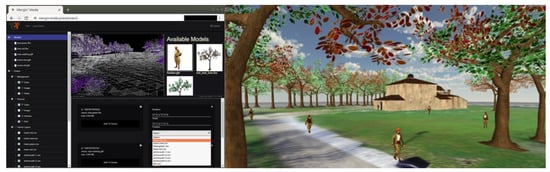
Figure 16.
Relating 3D models with typical shape geometries.
- Creating Immersive Experience with MERGIN’ MODE App
As stated, MERGIN’ MODE software components act complementary to each other. Therefore, the 3D scenes created by the MERGIN’ MODE Platform may be exported as Virtual Geospatial Worlds and imported into the MERGIN’ MODE App. These worlds may be revealed on the visitor’s visual display as soon as the visitor is placed in the location of the monument. Figure 17 displays virtual scenes reviving events of the past inside the CH building. These scenes may also be viewed on a classic browser off site and are available, among others, on the MERGIN’ MODE App site (app.merginmode.com)
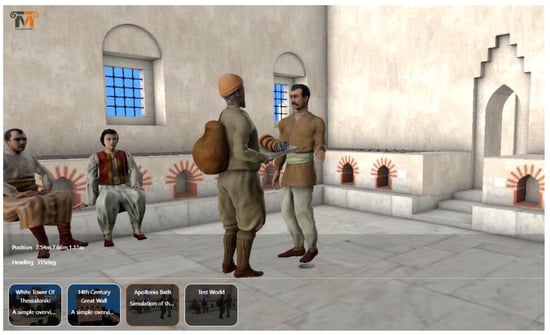
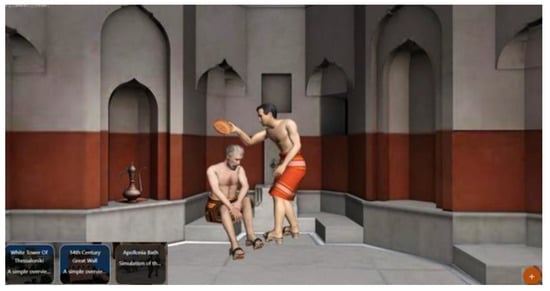
Figure 17.
Virtual humans populate the reconstruction of the bath. In this specific scene, a member of the bath’s staff welcomes a person in the first room of the bath’s complex and provides him with towels (available at app.meginmode.com).
5. Discussion and Conclusions
Digital documentation with the above-mentioned technologies as a means of the preservation and safeguarding of a CH site is based on retaining the image of its status so that probable future deterioration may be reversed on the basis of the visual and three-dimensional digital data already gathered. However, as valuable as this process may be, it cannot easily reverse the detrimental effects of time and human-related activities that downgrade the site’s structural integrity. The cases of the Soap Factory in Lod and the bath in Apollonia are indicative cases of CH buildings that, due to their relatively low cultural or historical value (as it may be perceived), have been subjected to various perils. This is directly related to the local community, authorities and stakeholders’ entrenched perception of the sites as non-visitable and as semi-derelict structures that may generate little interest and therefore has little to offer to the local economy and to the attractiveness of the location as a destination.
The question that arises is how new technologies may be used in more proactive ways so that monuments in the condition and status of the Lod Soap Factory and the bath in Apollonia can acquire attractiveness and become (re)inscribed in the fabric of local communities and economies, this time as visitors’ destinations. One answer is related to the ability of mixed reality (MR) to bring CH sites to life based on digital documentation and to recreate their past image and visually represent their past functions and modes of operation. This means that the already-completed work of the detailed acquisition of data through digital documentation and pertinent methods can form the basis for an MR experience that will be available to visitors on their portable devices/smartphones. This requires further work on historical documentation through research on archives, bibliography reviews and archeological investigations to retrieve, in the outmost detail, the way buildings, as well as their users (e.g., Soap Factory laborers’ clothing) looked in their original times. Such reconstructions present the state of contemporary knowledge about the buildings and their historical events. They can be updated as new findings come to light.
In fact, the overarching question that this paper addresses is how uses of photogrammetry and emerging technologies can safeguard CH sites and moreover promote their role as visitable destinations so that they can re-enter the social, economic and cultural life in their localities. This would engage and motivate a number of stakeholders, who would either benefit from such a local regeneration element or who are entrusted with the safeguarding of local heritage on an institutional level. In turn, this indicates that a successful reintegration of, e.g., a derelict factory in the fabric of local life, depends not only on the sophistication of the digital methodologies and tools that will bring it digitally back to life visually, but also on establishing a network of public and private stakeholders to maximize the impact of such applications in terms of promoting, offering services and ensuring basic visitor infrastructure. The procedure of a destination accreditation is indicative of the many aspects involved. While this aspect must be noted, nevertheless, it is not within the scope of this paper to analyze it at this point.
This publication focuses on ways that MR and GIS technology can create an exhilarating and historically accurate experience for visitors, drawing on the MERGIN’ MODE project on a heritage building of the Ottoman period in Greece. The fact that this Ottoman building, a bath, is situated in a rural area, as opposed to the Lod Soap Factory, which is within a city, is indicative of the potential of the latter to be inscribed in a network of urban sites of interest and, in any case, be within the path of even local residents, who will now have the opportunity to enjoy an MR experience recreating its past status on their mobile phones as they pass by. A synopsis of the tools, modes and functionalities of the MERGIN’ MODE will follow, showcasing the research procedure that led to these results, such as a tangible example of how the above question in relation to CH sites may be answered. In a nutshell, we are concerned here on the question of how digital documentation, which is in a sense a passive, non-intrusive process, may be further enhanced with emerging technologies so that it will lead to active methods of safeguarding a monument, by making it appeal to the wider public and stakeholders, thus attracting interest, preservation-related investment and once again acquire a real function.
Apart from progress in the technical field, it is important that the authorities (cities, municipalities, etc.) that have ownership of the CH sites understand the value of an accurate and comprehensive survey. A digital documentation can serve as a form of replication. It can be an accurate archive if the building undergoes damage from natural phenomena (earthquakes, flooding), as well as man-caused calamities (terrorism, bombing). In cases of damage, the CH building can be accurately reconstructed. This archive can also serve as a basis for digital reconstructions and can make the site accessible online.
Author Contributions
Conceptualization, S.S., K.E., R.V., E.S. and P.D.; methodology, K.E., R.V. and S.S.; software, K.E. and R.V.; validation, K.E., R.V. and E.S.; formal analysis, K.E. and R.V.; investigation, E.S., S.S., K.E., R.V. and P.D.; resources, K.E., R.V., E.S. and S.S.; data curation, K.E., R.V., E.S. and S.S.; writing—original draft preparation, S.S., K.E., R.V., P.D. and E.S.; writing—review and editing, E.S., S.S., K.E., R.V. and P.D.; visualization, K.E. and R.V.; supervision, S.S., R.V., K.E. and E.S.; project administration, K.E., R.V. and S.S. All authors have read and agreed to the published version of the manuscript.
Funding
This research received no external funding.
Conflicts of Interest
The authors declare no conflict of interest.
Acronyms-Abbreviations
| CH | Cultural Heritage |
| MR | Mixed Reality |
| HTC Vive | High Tech Computer Corporation Vive |
| BIM | Building Information Modeling |
| ITR | Imaging Topological Radar |
References
- Pavlidis, G.; Koutsoudis, A.; Arnaoutoglou, F.; Tsioukas, V.; Chamzas, C. Methods for 3D digitization of cultural heritage. J. Cult. Herit. 2007, 8, 93–98. [Google Scholar] [CrossRef]
- Vosinakis, S.; Koutsabasis, P. Evaluation of visual feedback techniques for virtual grasping with bare hands using Leap Motion and Oculus Rift. Virtual Real. 2017, 22, 47–62. [Google Scholar] [CrossRef]
- Papadopoulos, T.; Evangelidis, K.; Kaskalis, T.H.; Evangelidis, G.; Sylaiou, S. Interactions in Augmented and Mixed Reality: An Overview. Appl. Sci. 2021, 11, 8752. [Google Scholar] [CrossRef]
- Maietti, F.; Di Giulio, R.; Piaia, E.; Medici, M.; Ferrari, F. Enhancing Heritage fruition through 3D semantic modelling and digital tools: The INCEP-TION project (2018). In IOP Conference Series: Materials Science and Engineering, Volume 364, Florence Heri-Tech—The Future of Heritage Science and Technologies, Florence, Italy, 16–18 May 2018; IOP Publishing: Bristol, UK, 2018. [Google Scholar]
- Lancaster, J. Pre- and post-arson three-dimensional reconstructions of the Lichtenwalter schoolhouse, Green, Ohio (2018). Digit. Appl. Archaeol. Cult. Herit. 2018, 8, 1–9. [Google Scholar]
- Barratt, R.P. Recreating Neolithic Malta’s domestic environment: 3D Reconstruction of the Għajnsielem Road house. Digit. Appl. Archaeol. Cult. Herit. 2018, 10, e00081. [Google Scholar] [CrossRef]
- Vital, R.; Sylaiou, S. Digital survey: How it can change the way we perceive and understand heritage sites. Digit. Appl. Archaeol. Cult. Herit. 2022, 24, e00212. [Google Scholar] [CrossRef]
- Digital Roman Forum—IDRE Sandbox—UCLA. Available online: https://sandbox.idre.ucla.edu/sandbox/digital-roman-forum (accessed on 1 July 2022).
- Digital Cultural Heritage in Education—A Tool to Navigate Difficult Times. Available online: https://pro.europeana.eu/post/digital-cultural-heritage-in-education-a-tool-to-navigate-difficult-times (accessed on 1 July 2022).
- Bustillo, A.; Alaguero, M.; Miguel, I.; Saiz, J.M.; Iglesias, L.S. A flexible platform for the creation of 3D semi-immersive environments to teach Cultural Heritage. Digit. Appl. Archaeol. Cult. Herit. 2015, 2, 248–259. [Google Scholar] [CrossRef]
- Ceccarelli, S.; Guarneri, M.; Ferri de Collibus, M.; Francucci, M.; Ciaffi, M.; Danielis, A. Laser Scanners for High-Quality 3D and IR Imaging in Cultural Heritage Monitoring and Documentation. J. Imaging 2018, 4, 130. [Google Scholar] [CrossRef]
- Abate, D.; Baracca, M.C.; Ciavarella, R.; Furini, G.; Migliori, S.; Pierattini, S. Laser Scanner Technologies and 3D Models Integration: Analysis and Methodological Approach, Final Workshop of the Grid Projects of the Italian National Operational Programme 2000–2006 Call 1575. ISBN: 978-88-95892-02-3. 2009. Available online: https://www.eneagrid.enea.it/papers_presentations/papers/Proceedings_Workshop_FinalePONCatania2009.pdf (accessed on 1 July 2022).
- Bekele, M.K.; Pierdicca, R.; Frontoni, E.; Malinverni, E.S.; Gain, J. A Survey of Augmented, Virtual, and Mixed Reality for Cultural Heritage. J. Comput. Cult. Herit. 2018, 11, 1–36. [Google Scholar] [CrossRef]
- Nikolakopoulou, V.; Printezis, P.; Maniatis, V.; Kontizas, D.; Vosinakis, S.; Chatzigrigoriou, P.; Koutsabasis, P. Conveying Intangible Cultural Heritage in Museums with Interactive Storytelling and Projection Mapping: The Case of the Mastic Villages. Heritage 2022, 5, 1024–1049. [Google Scholar] [CrossRef]
- Rappel, J. The History of the Land of Israel from Prehistoric Times to the Rise of the 19th Century; Hebrew Publication: New York, NY, USA, 1980. [Google Scholar]
- Apollonia, ToposText, Aikaterini Laskaridis Foundation. Available online: https://topostext.org/place/406235UApo (accessed on 1 July 2022).
- Sylaiou, S.; Androudis, P.; Tsiapali, M.; Trivizadakis, N.; Ramnalis, D.; Polychronos, V.; Efopoulos, V.; Evangelidis, K. Cultural Heritage Documentation: The case study of the Ottoman Bath in Apollonia, Greece, RISE IMET 2021. In Proceedings of the International Conference on Emerging Technologies and the Digital Transformation of Museums and Heritage Sites, Nicosia, Cyprus, 2–4 June 2021; pp. 97–110. [Google Scholar]
- Evangelidis, K.; Sylaiou, S.; Papadopoulos, T. Mergin’ Mode: Mixed Reality and Geoinformatics for Monument Demonstration. Appl. Sci. 2020, 10, 3826. [Google Scholar] [CrossRef]
- Evangelidis, K.; Papadopoulos, T.; Papatheodorou, K.; Mastorokostas, P.; Hilas, C. 3D geospatial visualizations: Animation and motion effects on spatial objects. Comput. Geosci. 2018, 111, 200–212. [Google Scholar] [CrossRef]
- Evangelidis, K.; Papadopoulos, T.H.; Sylaiou, S. Mixed Reality: A reconsideration based on mixed objects and geospatial modalities. Appl. Sci. 2021, 11, 2417. [Google Scholar] [CrossRef]
Publisher’s Note: MDPI stays neutral with regard to jurisdictional claims in published maps and institutional affiliations. |
© 2022 by the authors. Licensee MDPI, Basel, Switzerland. This article is an open access article distributed under the terms and conditions of the Creative Commons Attribution (CC BY) license (https://creativecommons.org/licenses/by/4.0/).