Abstract
In order to create a cultural landscape, the number of different types of ecomuseums around the world, covering many sites, has recently increased. Their establishment aims at the protection of natural and cultural resources. The north area of Syros Island offers significant opportunities for the development of a museum model that promotes the sustainable development of the local community. The aim of this study is to investigate the feasibility of developing a museum model that promotes the sustainable development of the local community in Apano Meria, Syros Island, which is a representative site with natural, geological, and archaeological heritage. For this purpose, the engagement and participation of the local inhabitants was evaluated through various activities, the basic principles of which are based on the concepts of New Museology and, more specifically, those of ecomuseums. Qualitative research was carried out through on-site observations, including discussions, participant observation, documentation, and in-depth interviews with local people. This research revealed that, so far, the conservation of the Apano Meria landscape is mainly due to the action of local people, who have repeatedly been called upon to show strong resistance to external factors that threatened to alter it. In their long-term effort to preserve and protect the area, but also to develop it in terms of sustainable development, the idea of its possible future inclusion in the UNESCO Global Network of Geoparks was proposed.
1. Introduction
The new concept of geocultural landscape has been widely considered as a means of implementing and researching issues related to the protection of cultural heritage as it has evolved over time in a specific location of natural and geological interest [1]. The concept of landscape, in general, has a highly cultural aspect. The descriptive term “cultural” was added to express human interaction with the environment and the presence of tangible and intangible cultural values [2], whereas the “geocultural landscape” is defined as a specific and characteristic product of the interaction between a given human community, which incorporates certain cultural preferences, and a specific location that displays a wealth of natural, geological resources of research interest [3]. In other words, the geocultural landscape constitutes a tool of sustainable development that concerns the heritage of many eras of natural evolution and many generations of human activity [1].
The ecomuseum, on the other hand, where the local community has primary and final responsibility for its monitoring [4], contributes to the socio-economic development of the community through, not only cultural tourism and ecotourism, but also through the promotion of cultural heritage [5]. Ecomuseums are important because they focus on the sustainable development of a local community that is called upon to respond to the globalized and ever-changing economic conditions by promoting the heritage and the history of its landscape [6,7].
This article examines the geocultural landscape of Apano Meria, on the island of Syros, central Aegean Sea. Apano Meria is a geologically significant area on the island’s north side that has recently been studied for scientific and educational purposes [8]. However, the cultural landscape has not been explored, including the coexistence of human activity with the environment. The area of Apano Meria of Syros contains a significant number of geological, historical, and archaeological elements, making it a highly dynamic model of ecomuseum for the benefit of local sustainable development. The aim of this work is to highlight the geocultural features of the area from the perspective of Museology, so that they can be used as another research evidence that the area should be included in the UNESCO Global Geoparks Network, a network in which important geocultural landscapes are recognized worldwide, and benefit through sustainable development [9]. An additional goal of this work is to highlight the efforts of locals, who are collectively active in decision making through open assemblies, to preserve all the material and intangible features of their heritage, using New Museology features to integrate their area into a framework for cultural preservation and promotion of even greater importance. Since ecomuseums rely heavily on on-site conservation and interpretation of heritage, this article investigates a possible application of this model to the case study area, highlighting the relationship it may have with a potential geopark or any form of cultural conservation in general.
1.1. Clarifying the Concept of the Ecomuseum
An ecomuseum is defined as a dynamic museum model with the collective and productive goal of providing services, mainly to meet the needs for the benefit of the local community, through the interpretation and management of cultural heritage, promoting local and collective interest, strengthening local cohesion and subsequent development [10]. These services may be related to cultural, environmental, or educational activities. The ecomuseum focuses on people rather than organizations or objects, and its concept is based on the close relationship between the inhabitants of an area and their heritage [4,10], and it also acts as a tool for the development of the local community. The ecomuseum as a museological approach differs radically in concept from the traditional museum, as it performs its objectives within a completely different context. It is not housed in a building, nor does it have exhibits in the traditional form, but gives the visitor the opportunity to discover the cultural and environmental identity of an area, its material and intangible heritage, through a structured narrative and specific thematic routes proposed at predetermined starting points that also constitute information stations.
The term ‘ecomuseum’ was originally coined by Hugues de Varine, who was Director of the Secretariat of the International Council of Museums (ICOM) from 1965 to 1974. Prior to Hugues de Varine’s tenure as Director of the ICOM Secretariat, George Henri Rivière was one of the most important proponents of the ecomuseum movement [11]. In January 1980, he proposed the third definition of the ecomuseum. According to him, “an ecomuseum is an instrument conceived, fashioned and operated jointly by a public authority and a local population”; “the public authority’s involvement is through the experts, facilities and resources it provides; the local population’s involvement depends on its aspirations, knowledge and individual approach” [10]. Darko Babić [12] states that ecomuseums “change and adapt depending on time, space, and most of all, population, the community in which they operate and its developmental needs, so the definitions are also always evolutive”.
Ecomuseums first appeared in France in the 1970s. Today, there are over 400 ecomuseums operating around the world, with most of them located in European countries and with France, Italy, Spain, and Poland leading the way in the development of ecomuseums. Initially, the aim of this museum model was to promote holistic interpretations of cultural heritage by combining material objects, sites, and buildings with folklore and traditional aspects related to intangible cultural heritage and human activity [4,10,13]. At a later stage, this ecomuseum model was extended to include local flora and fauna [14], important wildlife habitats and geomorphologically interesting sites [4,13]. Consequently, the ecomuseum reflects the relationship of residents and visitors to the natural environment, and while diverse, it is spatially confined to a specific geographical area aiming at the involvement of the local community with emphasis on sustainable development [4,15]. It focuses on sustainable forms of community development, while at the same time, the local community is called upon to respond to the globalized and ever-changing conditions of the economy through the enhancement of its heritage and the history of its landscape [6,7].
In many cases, ecomuseums define geology as a central component of their mission [16,17]. Already in the 1970s and 1980s, new specific considerations arose regarding the promotion of geological sites, as well as the perception of the role of science museums. There is a strong tendency during these times to separate geology from the rest of the natural biological heritage. The first geological reserves were established in France, specifically because the scientific community believed that the specificities of geological sites were not sufficiently considered in promotion and conservation policies. In this context, the interpretive narrative for visitors gradually incorporated the geology issue. Thus, ecomuseums are gradually being established within national and regional natural parks, such as the Mount Lozère ecomuseum in Cévennes, which was founded in 1984. Canavese et al. [16], for example, stated that the ecomuseum was instrumental in revealing to the local population the existence and characteristics of a spectacular landscape sculpted by Pleistocene glaciations: the Ivrea Morainic Amphitheatre in the Italian Piedmont.
Corsane et al. [13] developed a list of 21 questions during fieldwork in Italy to assess how far ecomuseums reach the tenets of the philosophy and the impact that ecomuseums have on its participants. The key principles or indicators (referred to as “the 21 principles”) include specific reference to the idea of the ecomuseum being guided by the local community, allowing for democratic public participation from all stakeholders and interest groups in all decision-making processes and activities, and encouraging joint ownership and management with input from local communities, academic advisors, local businesses, local authorities, and governments. According to these principles, the most important key elements in the creation of an ecomuseum are the development of network activities, equal attention to immovable and movable material culture and intangible heritage resources, and sustainable development.
1.2. The Ecomuseum Model
The main feature of an ecomuseum model is the participation of the local community in dealing with all issues related to the preservation of cultural heritage [14], but mostly the ecomuseum was born so that the community makes decisions about its future (social, cultural, economic, etc.).
The final resolution of the ICOM General Assembly (Munich, 1968) calls for “museums to be recognized as important institutions in the service of development, because of the contribution they can make to cultural, social, and economic life” [12]. The Forum on Ecomuseums and Community Museums took place at that meeting [18]. The round table discussion held in May 1972 in Santiago, Chile, under the auspices of UNESCO, is considered a turning point because it essentially led to the idea of a new form of museum that serves as a link between society and its natural environment [19].
As early as the 1960s, a new generation of progressive museologists tended to redefine and review the role of museums in the community, emphasizing on the active role they should now play [12].
Taking into account the Declaration of Santiago, Chile (UNESCO, 1973), the ICOM Decisions on Communities, Sustainability and Cultural Landscapes, and the ICOM Decision on “Extended Museums” adopted at the ICOM General Assembly in Milan 2016, which pointed out that museums are important not only for their historic buildings, their collections and their established collections curation and promotion practices, but also for their value in terms of social, cultural, environmental and economic development, the 34th ICOM General Assembly proposes, inter alia, to contribute to the creation of community museums. Moreover, the same Assembly proposes the creation of ecomuseums promoting their reform character in the way they approach each community in terms of sustainability with smooth local development, as well as with protection and with highlighting geocultural landscapes [20].
2. Materials and Methods
2.1. The Study Area of Apano Meria on Syros Island
Syros Island belongs to the Cyclades complex, which forms the so-called Cycladic Plateau in the central Aegean Sea (Greece). The Cycladic Plateau is composed of 20 large islands that extend far from mainland Greece to the southeast and they are the peaks of submerged mountains that border with Evvoia and the Attica peninsula on the west (Figure 1).
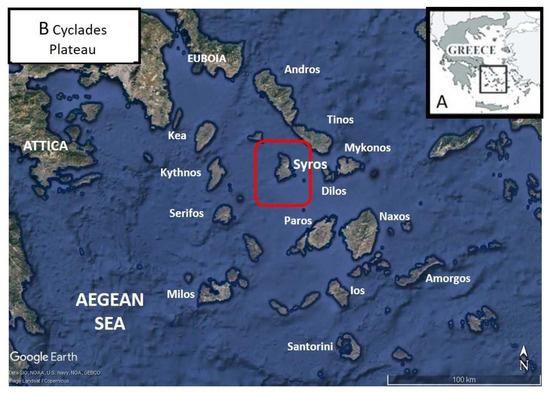
Figure 1.
(A) Sketch map of Greece indicating the location of Cyclades Plateau, (B) satellite photo of the Cyclades plateau, indicating the location of Syros Island.
Syros belongs to the administrative region of the South Aegean, which has a high potential for geotopes and geodiversity, clustered together in areas of high relief, most of which are connected to the coastal environment. These geotopes are abundant in areas associated with volcanic activity both during the Upper Miocene and the Pliocene–present (Milos, Santorini, and Nisyros). Syros Island is primarily composed of the Cycladic Blueschist Unit (CBU), which is known for its outstanding preservation of metamorphic HP–LT (High Pressure—Low Temperature) rocks such as eclogites and blueschists. As a result, many petrology, structure, and geochronology studies are being conducted on this island to unravel the tectonometamorphic evolution of the CBU subduction complex [8] (Figure 2 and Figure 3).
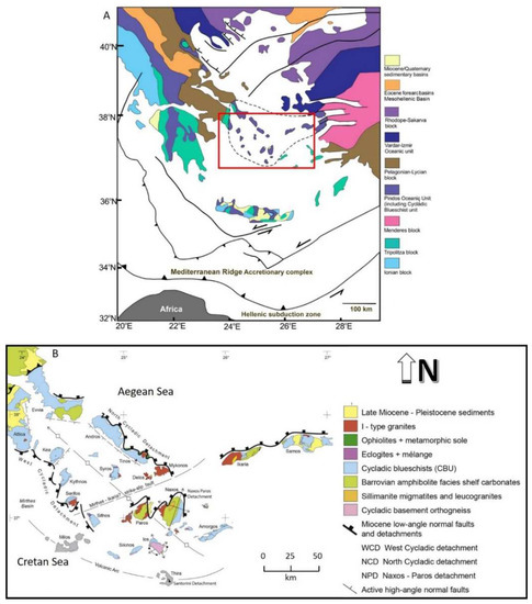
Figure 2.
(A). A simplified tectonic map showing the major tectonic zones above the Hellenic subduction zone of the Aegean region (modified after [8,21,22]), (Β). Simplified geological map of the Attic-Cycladic Crystalline Belt, showing the major tectonic units [21] (modified).
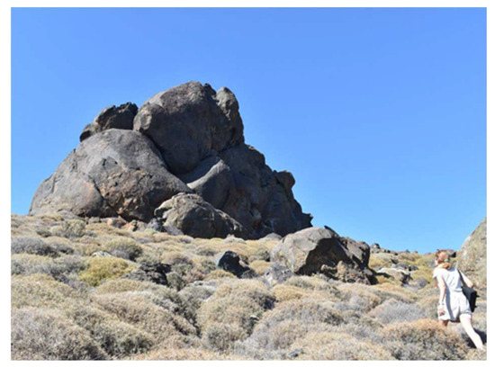
Figure 3.
Eclogitic monolith locally known as “aerolithos”, from near to Lia Beach.
Syros is characterized by the presence of some of the oldest elements of human presence. In the area, in scattered places, elements of the Early Cycladic and Hellenistic eras are found [23] (Figure 4). Villages such as Kastri and Chalandriani are prehistoric settlements [23,24] dating to the end of the Early Cycladic period II (2800–2300 BC). Additionally, the villages of Richopo are important, next to which there is the cave of Ferekidis, the great philosopher, teacher of Pythagoras and inventor of the first sundial, and Grammata, where there are rocks with engraved inscriptions of seafarers dating from classical antiquity to the Middle Ages [23]. The peculiar cultural characteristics that appear over the years in these sites testify that the colonization of Syros, at the end of the Neolithic Age to the beginning of the Bronze Age, was created by different groups, which may have coexisted in the same area [25].
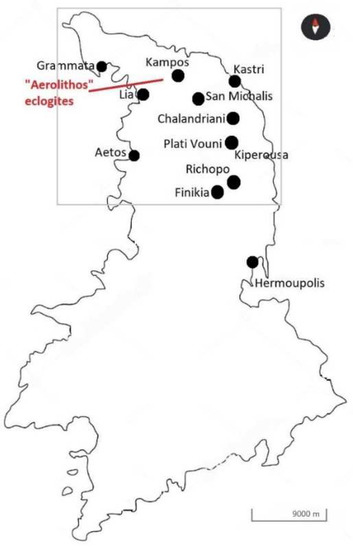
Figure 4.
Schematic map of Syros Island, indicating the sites of archaeological interest surrounding the “Aerolithos” eclogite geosite.
The preserved rural landscapes that host human activities such as agriculture, viticulture, livestock and beekeeping and traditional settlements and wildlife habitat offer great opportunities for the preservation of environmental stability by contributing to the sustainable development of the island.
Apano Meria is an area on the north side of the island and has an important geological heritage which has been researched in recent years for scientific and educational purposes. The geocultural landscape of Apano Meria represents an important part of the community geological heritage and not only, both at island and regional levels as it is an important and highly representative site for the analysis of the structure of a subduction zone which is a major component of the earth’s lithosphere [8].
However, the cultural landscape holistically, including the coexistence of human activity with the environment, is rarely explored. More specifically, the natural and geocultural landscape of Apano Meria presents innumerable features of exceptional importance at an environmental, archaeological and historical level [6,23], whereas the possibilities of local development through a “museum dialogue” [26] are many, not only for the geological, historical and cultural significance, but also in terms of the wider territorial frame and the socio-cultural, folklore and historical identity of local populations.
2.2. Methodology
To comprehend the dimensions of the geocultural landscape and the application of New Museology concepts to it, bibliographic and field research were conducted, focusing primarily on the multidimensional cultural aspects of the locals, using a qualitative data collection method that included participant observation of the number of activities implemented by joint decision through open assemblies.
In-depth interviews and discussions were held to analyze locals’ knowledge of their place and community [27] in order to ensure the emergence of unique features of their place for the benefit of sustainable development (Figure 5). This study was based on qualitative research methods such as semi-structured field interviews with key informants and participant observation of human-land interactions using the snowball sampling method (geological and environmental phenomena). We chose this sampling method to identify one or two individuals to include in our study, and then rely on these initial participants to identify additional study participants [28].

Figure 5.
Research methodology scheme followed in this paper.
The primary data were collected during a twenty-day field research in May 2021. The researcher participated as a moderate participant [29] observer while the site selection criteria were based on natural-cultural characteristics. The researcher invited participants who live in settlements in the Apano Meria area and provide a variety of services to investigate the interaction between man and nature. A combination of research methods (triangulation) [30] were used to collect qualitative data during the on-site visits, which included an in-depth biographical narrative interview and focus groups discussions with 12 respondents. The respondents were divided into three groups: founding members of an Aegean ecological network (3 respondents), residents (7 respondents) and members of the Social Cooperative Enterprise Apano Meria (2 respondents). All respondents and key informants were asked questions to obtain information about local knowledge, perceptions and interactions with the area’s landscapes and points of interest. Apano Meria’s tangible and intangible cultural heritage is explored through five aspects: (1) geomorphology, (2) landmarks, (3) natural resources, (4) history/archeology and (5) folklore. At this point, the research is supported with some quantitative tools. More specifically, respondents’ questions based on the twenty-one fundamental principles that can serve as indicators of ecomuseology philosophy in practice [31] are quantified on a Likert scale [32].
3. Results
Discussions with residents of Apano Meria about the area include data on geodiversity, natural resources, toponyms, history/archeology, and folklore of the sites, in order to understand the long-term interaction of human activity with the environment to date. The literature and on-site research resulted in the following elements of the geocultural landscape, as summarized in Table 1.

Table 1.
Geocultural landscape components in Apano Meria’s villages—selection criteria of ecomuseum potentials.
The data from Table 1 show that the inhabitants still use the natural resources with traditional and geopolitically friendly habits. Most of the inhabitants are engaged in agriculture and livestock using traditional means, whereas in the village of San Michalis the well-known cheese with the Protected Designation of Origin (PDO) is produced.
The literature review was conducted in order to establish the typology on which the ecomuseum approach of the case study is based. The following points are highlighted in this context (Figure 6):
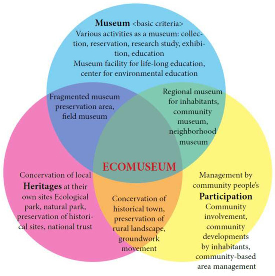
Figure 6.
The main concept of an ecomuseum based on [4].
- The specific geographical area that includes all cultural, social and environmental values that define a unique local heritage;
- The in situ preservation and interpretation of specific features of the geocultural landscape;
- The active participation of the people of the local community in the selection and management of the place [33].
The proposed implementation of an ecomuseum model in Apano Meria of Syros consists of three strategies: Community Participation, Sustainable Development and In Situ Conservation; these strategies create favourable conditions for synergies between residents in order to preserve the landscape and strengthen alternative tourism forms.
The residents’ interviews, which were based on the 21 fundamental principles of ecological museums, revealed the following (Figure 7, Figure 8, Figure 9, Figure 10, Figure 11, Figure 12, Figure 13, Figure 14, Figure 15, Figure 16, Figure 17, Figure 18, Figure 19, Figure 20, Figure 21, Figure 22, Figure 23, Figure 24, Figure 25, Figure 26 and Figure 27):
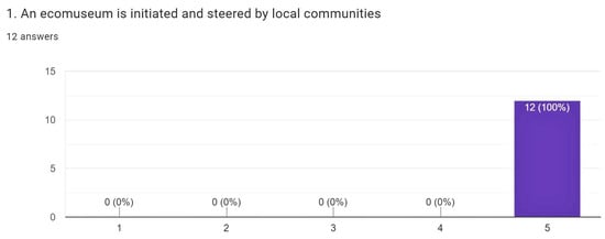
Figure 7.
Qualitative representation of Principle 1.
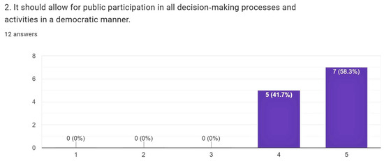
Figure 8.
Qualitative representation of Principle 2.
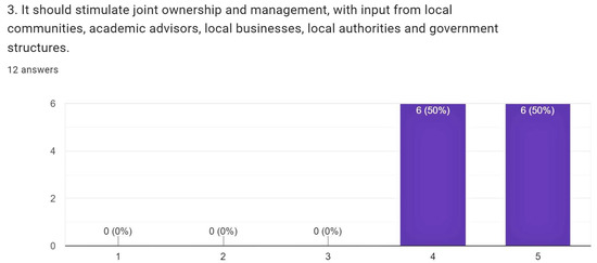
Figure 9.
Qualitative representation of Principle 3.
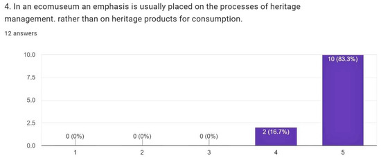
Figure 10.
Qualitative representation of Principle 4.
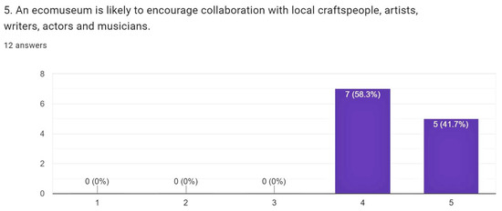
Figure 11.
Qualitative representation of Principle 5.
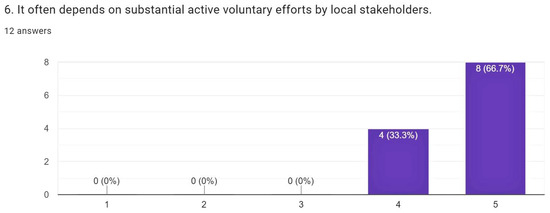
Figure 12.
Qualitative representation of Principle 6.
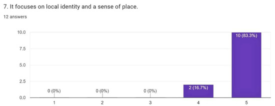
Figure 13.
Qualitative representation of Principle 7.
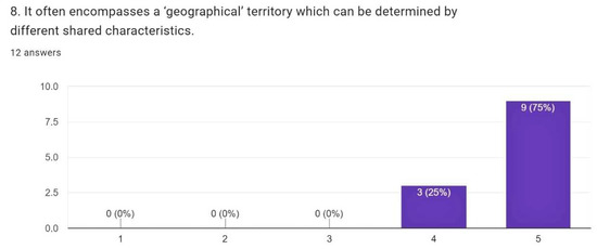
Figure 14.
Qualitative representation of Principle 8.
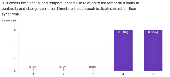
Figure 15.
Qualitative representation of Principle 9.
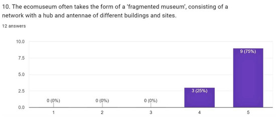
Figure 16.
Qualitative representation of Principle 10.
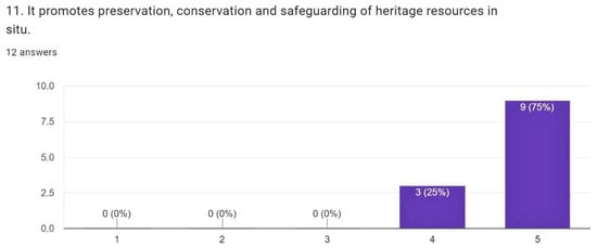
Figure 17.
Qualitative representation of Principle 11.
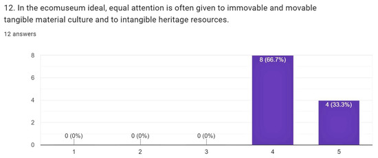
Figure 18.
Qualitative representation of Principle 12.
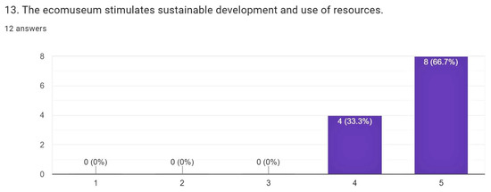
Figure 19.
Qualitative representation of Principle 13.
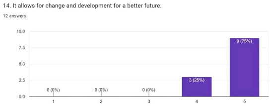
Figure 20.
Qualitative representation of Principle 14.

Figure 21.
Qualitative representation of Principle 15.
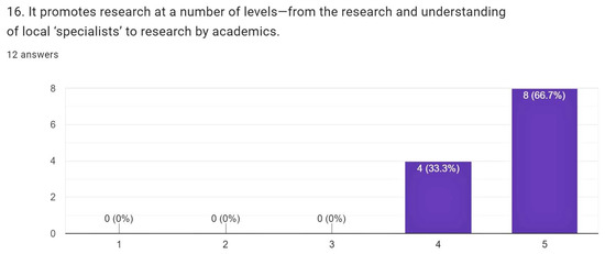
Figure 22.
Qualitative representation of Principle 16.
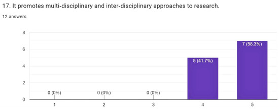
Figure 23.
Qualitative representation of Principle 17.

Figure 24.
Qualitative representation of Principle 18.
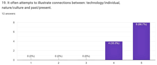
Figure 25.
Qualitative representation of Principle 19.
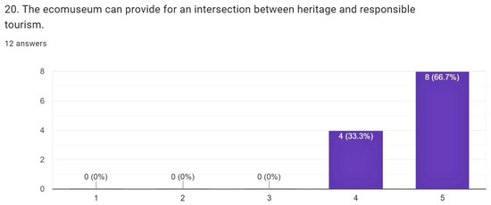
Figure 26.
Qualitative representation of Principle 20.
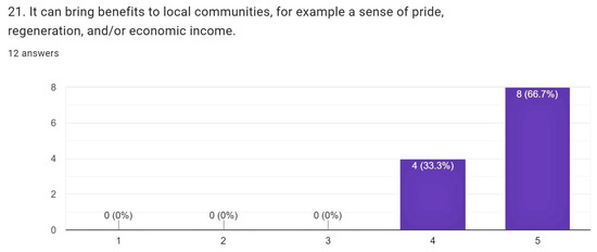
Figure 27.
Qualitative representation of Principle 21.
Regarding mainly the mobilization of the local community and overall project management by the locals but also collaboration with the local authorities, researchers, and local bodies (Principles 1 and 3), this project was born from the inhabitants’ “social desire” not to alter the area and to develop alternative tourism. Already, the Municipality, the University of the Aegean, the Social Cooperative Enterprise “Apano Meria”, the non-profit organization Cyclades Preservation Fund, which raises funds from people and companies that love the Cyclades, and a number of other organizations that have already succeeded in announcing the “Gyaros Marine Park”, are called to cooperate sufficiently, so that Syros becomes an important factor in the implementation of the UNESCO sustainable development goals until 2030.
Concerning the democratic decision-making process (Principle 2), the residents, as previously stated, participated in the initiative through open assemblies held in the University amphitheater, in Hermoupolis. They first talked about the difficulties they were having dealing with aggressive tourism, and then they shared their vision of promoting a mild form of tourism with respect to Syros insularity, landscape and history.
Concerning the emphasis to be placed on cultural heritage management processes rather than cultural heritage products for consumption (Principle 4), as formulated through assemblies, the common demand shared by the inhabitants was, above all, the revival and return. of traditional crops in Apano Meria, the disclosure of geological and archaeological treasures of the island, the creation of geopaths, and generally the declaration of the area as a geopark that will protect and highlight the geocultural heritage, preventing projects that would offer immediate economic benefits.
Concerning the synergy with local craftsmen and artists, but also the voluntary nature of the participation of the local bodies (Principles 5 and 6), the inhabitants have prepared and published a series of activities related to the flora, fauna, sights, and landmarks. At the same time, painting and photography exhibitions on “nature and man through time” and “in the pursuit of Syros geological treasure”, as well as music events, were held. According to ethnomusicologists, the region and its role [34] are emphasized, defining the people’s “sense of place”. It should be noted here that detailed information on the events and activities of residents that fall within the concept of an ecomuseum and have been carried out by them in the past is beyond the scope of this article. This issue will be explored in detail in subsequent publications.
Regarding the sense of place, its timeless aspect, as well as the geographical area in which it is defined (Principles 7, 8 and 9), it became clear that the residents, in collaboration with the local authorities and local bodies, carried out a series of actions and events such as lectures, workshops, exhibitions, revival of agricultural activities through traditional means, educational activities in places of geological and archaeological interest, as well as the publication of books on history, folklore, environment and human activities over the years. Some examples of these are workshops for viticulturists on the creation of new and old vineyards, seminars on organic farming, studies by university professors on the identification and treatment of beekeeping problems or entomological enemies of crops of all ages, guided tours archaeologists in places of interest, restoration of paths leading to places of geological interest, etc. As previously stated, the geographical area within which all of these actions are delimited is limited to the specific villages of the northern part of the island (Figure 3) that present this local geomorphological peculiarity and where visitors are allowed to explore a number of important and rare geological phenomena that give an idea of the processes that operate on Earth.
Regarding the network of different sites, the protection and promotion of the intangible and tangible cultural heritage and their on-site conservation (Principles 10, 11 and 12) as presented in Table 1, including the use of resources and human interactions with environmental and natural factors (Principles 15 and 18), sustainable development (Principle 13) is stimulated by all local efforts to promote agricultural production (agriculture, beekeeping, viticulture, animal husbandry, etc.) and the idea of alternative and quality tourism (Principles 20 and 21) such as educational, nature-loving, walking, archeological, geological tourism that will last all year round. In addition, all efforts have been made to create a geological exhibition that will include interactive reports as well as the interconnection of various geological routes with it and with digital applications (Principle 19).
Concerning the contribution of the project for a better future through environmentally friendly tourism accessible to all social statuses and ages (Principles 14, 21) the full range of ongoing activities is included, with the ultimate goal of integrating the region in the network of UNESCO global geoparks. The promotion of interdisciplinary research at various levels by academics and experts (Principles 16, 17) is carried out through the collaboration of various bodies such as the University of Aegean, the National and Kapodistrian University of Athens, the Directorate of Forests Cyclades, the Cyclades Development Company, the associations of teachers of Secondary Education, the Archaeological Service, the Hellenic Society of Environment and Culture, the Friends of Nature, but also with dozens of geological institutes from all over the world.
4. Discussion
4.1. Apano Meria of Syros Island: People and Their Land
According to the interviews with the inhabitants of Apano Meria, they are still engaged not only with their cultural traditions but also with agricultural activities that connect their past with their present, passing on information about people’s interdependence with their environment, from generation to generation. They revitalize and enrich their ancestors’ remaining tangible and intangible cultural heritage through agriculture, beekeeping, viticulture, and animal husbandry. They continue to live and exploit natural resources in natural landscapes with flora and fauna. Examples include the re-use of old vineyards and the traditional beating of grapes in stone-built traditional settlements, the techniques of dry cultivation of fruits, vegetables and legumes in prehistoric citadels with Early Cycladic-era cemeteries, the livestock and cheese production in settlements of Early Bronze Age, where the well-known Cycladic figurines were discovered, and beekeeping in important habitats. The unique geotopes, which are the result of rare geodynamic phenomena dating back to the Eocene, are also noteworthy (Table 1).
Therefore, the interviews revealed that the use of the landscape by the locals has remained consistent over time, with only minor alterations. Locals have been activated in recent years, driven by the desire to preserve all this heritage, through some actions that enhance sustainable development, attempting to preserve the cultural value of the landscape more than its direct economic benefit. These decisions to prevent the establishment of development projects in the region were made democratically, through open assemblies. Road infrastructure, dam construction projects, wind farm installation projects, even tourist resort construction projects, the establishment of an airport for charter flights, and other projects, have been thwarted. The inhabitants’ awareness of all these issues concerning the protection of their heritage, combined with their decision to pursue more alternative forms of tourism, explains why the entire landscape of the northern part of the island has remained unchanged. In their long-term effort to preserve and protect the site, but also to highlight it in terms of sustainable development, the idea of its possible future inclusion in the UNESCO Global Geoparks Network was proposed.
As is already known [9], a geopark can be the result of a long community-based development process that begins with purely local cultural-historical heritage and progresses through the surrounding landscape and natural resources, then to a wider area, and finally to its geological features. The scientific community knows of ecomuseums that have established geoparks, ecomuseums that have made geology one of their primary dimensions and are in charge of significant geological sites (e.g., [16]). According to Canavese et al. [16], a typical example is the Spanish Comarca of Maestrazgo, which is one of the most famous reports of ecomuseum innovation. In its initial stage of development, it appeared as a ‘Cultural Park’, covering 43 municipalities, villages and small towns. The discovery of paleontological remains and the initiative of a local man to create a theme park for dinosaurs, with dummies, led to the designation of Maestrazgo, as a geopark. Furthermore, one of the most prominent examples is the Paysalp ecomuseum, which “adopted” Mount Vouan in the Haute-Savoie region (near Geneva), which was a major millstone mining area until the nineteenth century.
4.2. The Ecomuseulogical Approach
This article provides an overview of how the Apano Meria’s geocultural landscape can be linked to the wider area’s possible inclusion in the list of UNESCO Global Geoparks. Although this is the first research attempt focusing on the relationship between people and landscape through the perspective of Museology, actions and research on socio-cultural and environmental issues vary, particularly among those who live there but also among those who have admired this place. The community ecomuseum, on the other hand, is recommended to be used in every design and development of their living environment, with the goal of preserving the culture and natural resources in their original state [7,35,36]. The research focuses primarily on the cultural appearance of the landscape, as evidenced by the local knowledge of Apano Meria residents, and is founded on the collection of information on the implementation, conservation planning and management strategies of a museum model, the ecomuseum. This research finding enhances the activation of Apano Meria inhabitants and encourages them to maintain their identity through natural heritage and the preservation of local activities and traditions. Furthermore, it is another scientifically substantiated finding supporting the importance of preserving the site and adding it to the Global Geoparks Network list. The cultural and natural characteristics of the area are primarily adapted to the quality of life of the inhabitants of Apano Meria, and as a result, they encourage more alternative forms of tourism, than the “aggressive tourism” that occurs on the surrounding islands. Museology, with the proposal of developing and implementing an ecomuseum, can be added to the fields of research that have so far approached the area of the case study from a holistic standpoint.
Similar cases where ecomuseums record, interpret, improve and promote elements of the local community and environment can be found in Piedmont, Italy and Seixal, Portugal. In addition, the Ecomusée Paysalp in France, the Ecomuseo delle Miniere e della Val Germanasca in Turin and the Ekomuseum Bergslagen in Sweden are related to geodiversity and have a strong geological component.
5. Conclusions
Today’s rapid growth rates may have an impact on the previously unaffected natural environment of Apano Meria, in northern Syros. All these cause landscape changes and threaten the extinction of all resources related to natural and cultural heritage, as well as all local traditions between the local community, which have been primarily responsible for their protection and preservation thus far. As a result, the preservation of Apano Meria’s geocultural landscape through an ecomuseum model is required to highlight the area and its activities. This research has revealed that, so far, the preservation of the Apano Meria landscape has been primarily due to the action of the locals, who have been repeatedly called upon to demonstrate strong resistance to external factors that have threatened to alter it. The skills and techniques that have been developed are a very useful tool for proper geocultural management in order to achieve sustainable landscape development. The museum is being asked to comply with a series of contemporary, cultural, social, and political developments, as well as to re-evaluate every human endeavor by refuting the “monolithicity” of the museological system, which is a hallmark of the new museology. The landscape shapes relationships, traditional activities, and all the characteristics that keep the inhabitants’ identity alive, whereas their conscious acceptance of long-term integration into the Global Network of Geoparks and active participation are the best guarantees for the project’s achievement and success. Furthermore, in many cases, ecomuseums define geology as the central factor of their action, whereas when an analysis of their action is presented, various examples of good practices in different contexts that are in line with the principles of geotopes and geoparks can be offered.
Author Contributions
Conceptualization, T.T. and H.D.; methodology, T.T.; formal analysis, T.T.; investigation, T.T.; resources, T.T. and H.D.; data curation, T.T., writing—original draft preparation, T.T.; writing—review and editing, H.D.; supervision, H.D. All authors have read and agreed to the published version of the manuscript.
Funding
This research received no external funding.
Institutional Review Board Statement
Not applicable.
Informed Consent Statement
Not applicable.
Data Availability Statement
The data presented in this study are available on request from the corresponding author.
Acknowledgments
The authors would like to thank all the residents of the island of Syros who willingly participated in the interviews. Special thanks are due to Teo Romvos, Hara Pelekanou and Dionysios Stravopodis for the analysis and evaluation of the data obtained from the interviews. Finally, the authors wish to thank the unknown reviewers of the manuscript.
Conflicts of Interest
The authors declare no conflict of interest.
References
- Rinalduzzi, S.; Farroni, L.; Billi, A.; De Filippis, L.; Faccenna, C.; Poncia, P.P.; Spadafora, G. Geocultural landscaping: Guidelines and conceptual framework to design future scenarios of exploited lands. Land Use Policy 2017, 64, 258–281. [Google Scholar] [CrossRef]
- Mitchell, N.; Rössler, Μ.; Tricaud, P.-M. UNESCO 2009, World Heritage Cultural Landscapes, a Handbook for Conservation and Management, World Heritage Papers No. 26. Available online: https://whc.unesco.org/documents/publi_wh_papers_26_en.pdf (accessed on 23 November 2021).
- Bender, O.; Evelpidou, N.; Krek, A.; Vassilopoulos, A. Geoinformation Technologies for Geo-Cultural Landscapes: European Perspectives; Taylor & Francis Group: London, UK, 2009; p. 4. [Google Scholar]
- Davis, P. Ecomuseums A Sense of Place; Leicester University Press: London, UK; New York, NY, USA, 1999; p. 75. [Google Scholar]
- Magliacani, M. Managing Cultural Heritage: Ecomuseum, Community Governance and Social Accountability; Palgrave Macmillan: London, UK, 2015. [Google Scholar]
- Davis, P. Ecomuseums and Sustainability in Italy, Japan and China. Concept adaptation through implementation. In Museum Revolutions: How Museums Change and Are Changed; Knell, S., MacLeod, S., Watson, S., Eds.; Routledge: London, UK, 2007; pp. 198–214. [Google Scholar]
- Ross, M. Interpreting the new museology. Mus. Soc. 2004, 2, 84–103. [Google Scholar] [CrossRef]
- Drinia, H.; Tsipra, T.; Panagiaris, G.; Patsoules, M.; Papantoniou, C.; Magganas, A. Geological Heritage of Syros Island, Cyclades Complex, Greece: An Assessment and Geotourism Perspectives. Geosciences 2021, 11, 138. [Google Scholar] [CrossRef]
- Zafeiropoulos, G.; Drinia, H.; Antonarakou, A.; Zouros, N. From Geoheritage to Geoeducation, Geoethics and Geotourism: A Critical Evaluation of the Greek Region. Geosciences 2021, 11, 381. [Google Scholar] [CrossRef]
- Rivière, G.H. The ecomuseum—an evolutive definition. Mus. Int. 1985, 37, 182–184. [Google Scholar] [CrossRef]
- Corinto, G. The Ecomuseum of George Henri Rivière. Int. J. Anthropol. 2020, 35, 35–56. [Google Scholar] [CrossRef]
- Babić, D. Experiences and (Hidden) Values of Ecomuseums; Faculty of Humanities and Social Sciences in Zagreb, Information Sciences Department: Zagreb, Croatia, 2009; pp. 237–252. [Google Scholar]
- Corsane, G.; Davis, P.; Elliott, S.; Maggi, M.; Murtas, D.; Rogers, S. Ecomuseum Performance in Piemonte and Liguria, Italy: The Significance of Capital. Int. J. Herit. Stud. 2007, 13, 224–239. [Google Scholar] [CrossRef]
- Edward, P.A. Artur Hazelius and Skansen: The Open Air Museum. In Museum Masters: Their Museums and Their Influence; AltaMira Press: Lanham, MD, USA, 1995; pp. 275–391. [Google Scholar]
- Donghai, S. The Concept of the Ecomuseum and its Practice in China. Mus. Int. 2008, 60, 29–39. [Google Scholar] [CrossRef]
- Canavese, G.; Gianotti, F.; de Varine, H. Ecomuseums and geosites community and project building. Int. J. Geoheritage Park. 2018, 6, 43–62. [Google Scholar] [CrossRef]
- Van Geert, F. In situ interpretation and ex situ museum display of geology. New opportunities for a geoheritage based dialogue? Int. J. Geoheritage Park. 2019, 7, 129–144. [Google Scholar] [CrossRef]
- Riva, R. Ecomuseums and Cultural Landscapes. State of the Art and Future Prospects; Magglioli Editore: Santarcangelo di Romagna, Italy, 2017. [Google Scholar]
- Mayrand, P. The new museology proclaimed. Mus. Int. 2018, 37, 200–201. [Google Scholar] [CrossRef]
- ICOM—Hellenic National Committee. 1–79: ICOM Newsletter, International Museum Day 2019, Volume 16, 2019. Available online: https://icom-greece.mini.icom.museum/wp-content/uploads/sites/38/2020/04/ICOM_16_2019_WEB_compressed.pdf (accessed on 12 August 2021).
- Jolivet, L.; Brun, J.-P. Cenozoic geodynamic evolution of the Aegean. Acta Diabetol. 2008, 99, 109–138. [Google Scholar] [CrossRef]
- Ring, U.; Glodny, J.; Will, T.; Thomson, S.N. The Hellenic subduction system: High pressure metamorphism, exhumation, normal faulting and large-scale extension. Annu. Rev. Earth Planet. Sci. 2010, 38, 45–76. [Google Scholar] [CrossRef]
- Romvos, T. Traces—The Stone Chronicle of Syros; Ministry for the Aegean: Mytilene, Greece, 2002; pp. 17–22.
- Stefanos, K. Inscriptions of the Island of Syros Mostly Unpublished after Topographic and Historical Observations about Ancient Syros; Athens, Greece. 1875. [Google Scholar]
- Aron, F. Aspects of Ancient Syros; KEO: Athens, Greece, 1979. [Google Scholar]
- Alpers, S. The Museum as a Way of Seeing. In Exhibiting Cultures, The Poetics and Politics of Museum Displays; Karp, I., Lavine, S., Eds.; Smithsonian Institution Press: Washington DC, USA, 1991; pp. 25–32. [Google Scholar]
- Bennett, T. The Birth of the Museum; Routledge: London, UK, 1995; pp. 102–105. [Google Scholar]
- Simkus, J. Snowball Sampling: Definition, Method and Examples. Simply Psychology. 2022. Available online: www.simplypsychology.org/snowball-sampling.html (accessed on 28 July 2022).
- DeWalt, K.M.; DeWalt, B.R. Participant observation. In Handbook of Methods in Cultural Anthropology; Bernard, H.R., Ed.; AltaMira Press: Walnut Creek, CA, USA, 1998; pp. 259–300. [Google Scholar]
- Denzin, K. Sociological Methods: A Sourcebook; Aldine Transaction: New Brunswick, NJ, USA, 2006. [Google Scholar]
- Corsane, G. From ‘Outreach’ to ‘Inreach’: How Ecomuseum Principles Encourage Community Participation in Museum Processes, Communication and Exploration; Forbidden City Publishing: Beijing, China, 2006; pp. 109–111. [Google Scholar]
- Nemanja, J. Likert Scale: How to Create Your Own Survey. LeadQuizzes. 2020. Available online: https://www.leadquizzes.com/blog/likert-scale/ (accessed on 18 January 2022).
- Shelton, A.A. Museums and Anthropologies: Practices and Narratives. In A Companion to Museum Studies; MacDonald, S., Ed.; Blackwell Publishing: Oxford, UK, 2006; pp. 64–80. [Google Scholar]
- van der Hoeven, A.; Hitters, E. The social and cultural values of live music: Sustaining urban live music ecologies. Cities 2019, 90, 263–271. [Google Scholar] [CrossRef]
- Pisofides, A. The Ecomuseum: Its Contribution to Cultural and Economic Development, Ecomuseum in Greece, Archeology and Arts. 1986. Available online: https://www.archaiologia.gr/wp-content/uploads/2011/06/20-12.pdf (accessed on 4 March 2022).
- Corsane, G. Using ecomuseum indicators to evaluate the Robben Island Museum and World Heritage Site. Landsc. Res. 2006, 31, 399–416. [Google Scholar] [CrossRef]
Publisher’s Note: MDPI stays neutral with regard to jurisdictional claims in published maps and institutional affiliations. |
© 2022 by the authors. Licensee MDPI, Basel, Switzerland. This article is an open access article distributed under the terms and conditions of the Creative Commons Attribution (CC BY) license (https://creativecommons.org/licenses/by/4.0/).