A Multidisciplinary Approach for Historic Buildings Diagnosis: The Case Study of the Kaisariani Monastery


 ,
, 

Abstract
1. Introduction
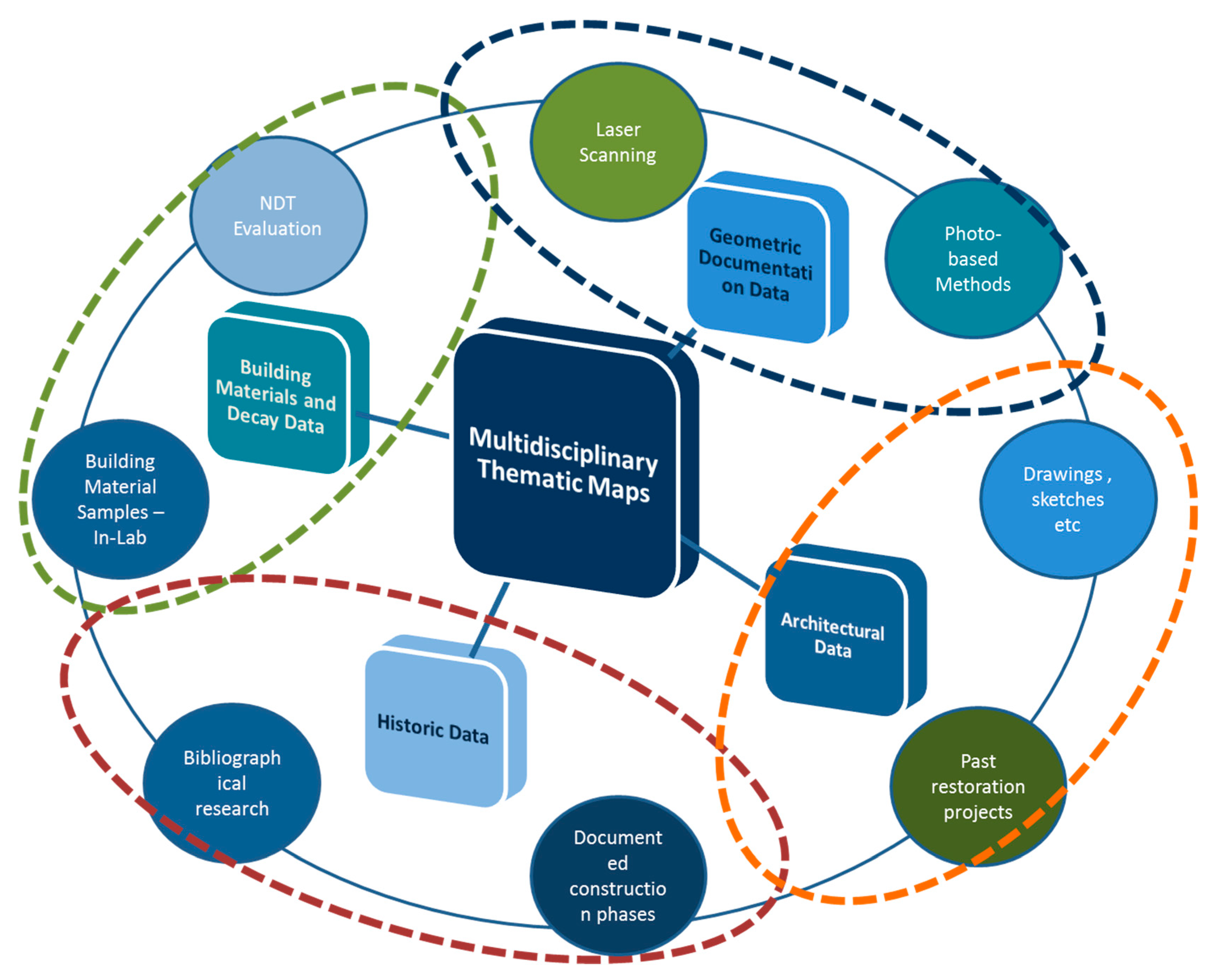
2. Materials and Methods
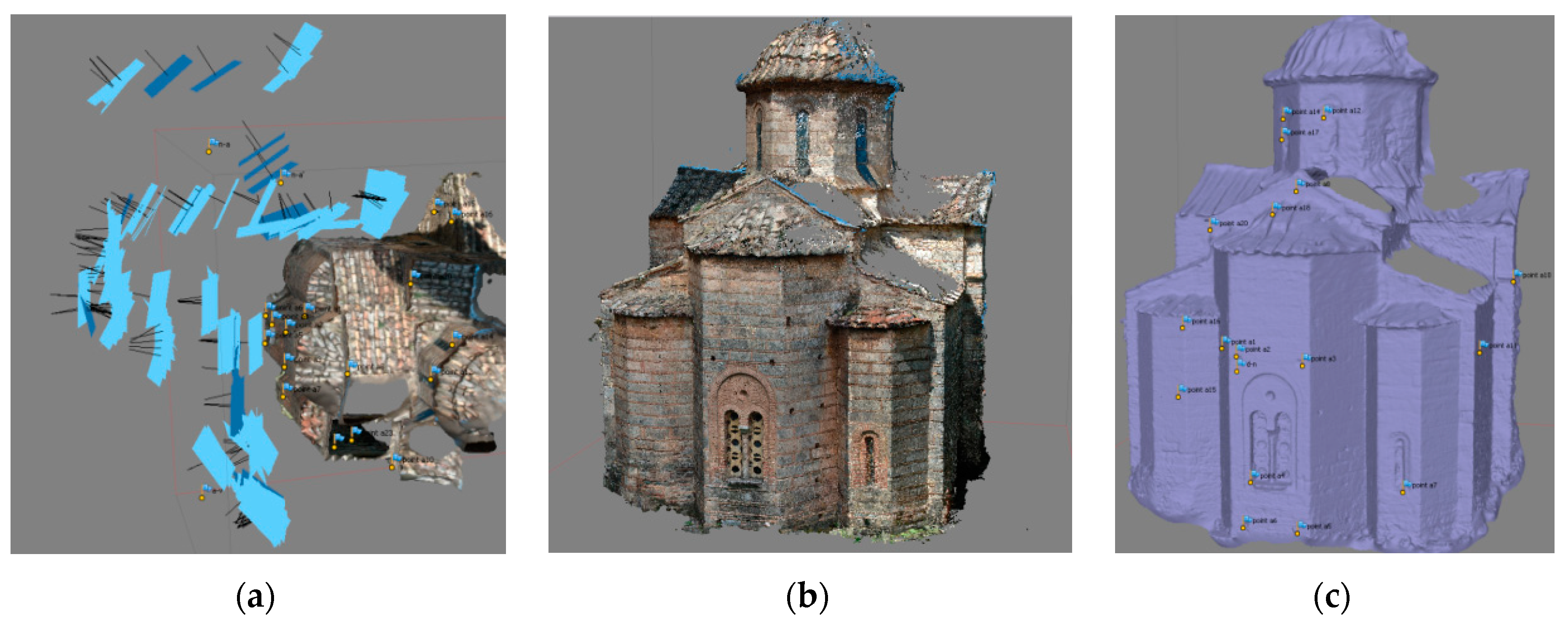
2.1. Geometric Documentation
2.1.1. Photo-Based Data Acquisition
2.1.2. Laser Scanning Data Acquisition
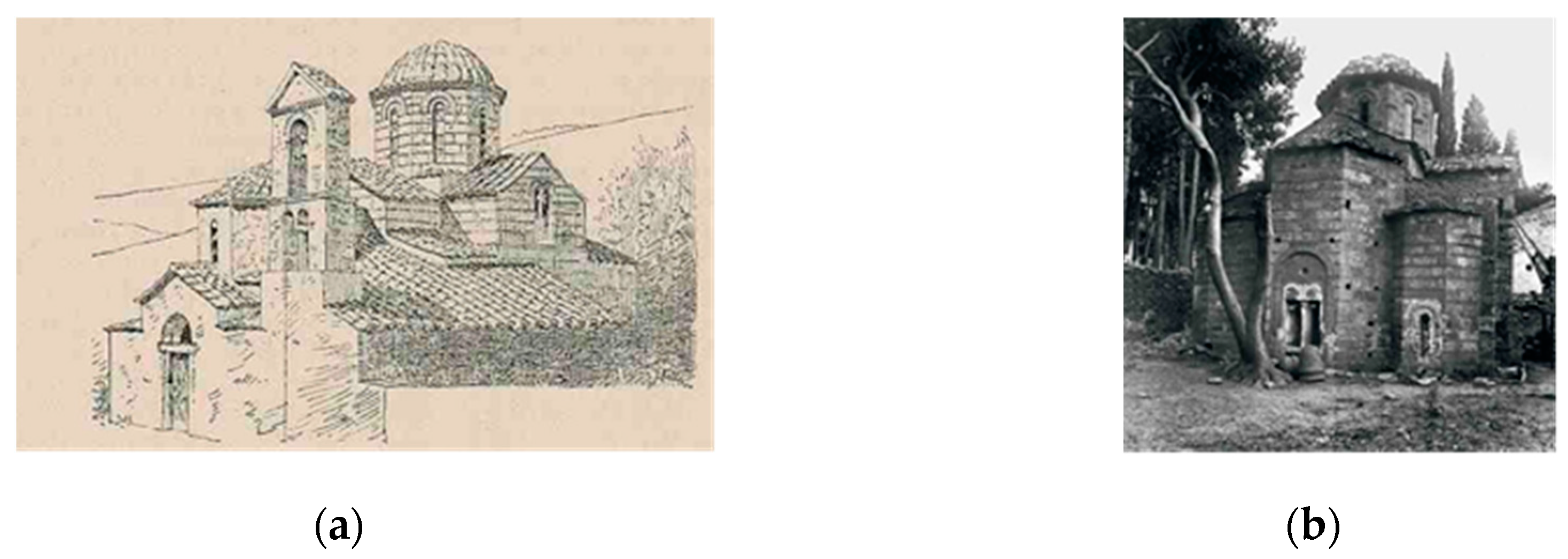
2.2. Architectural and Historical Documentation
2.3. Building Materials Characterization
3. Results
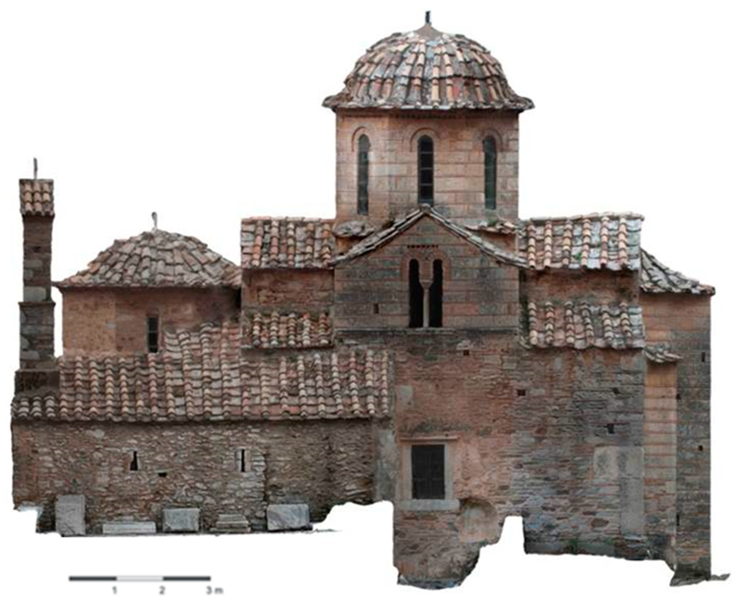
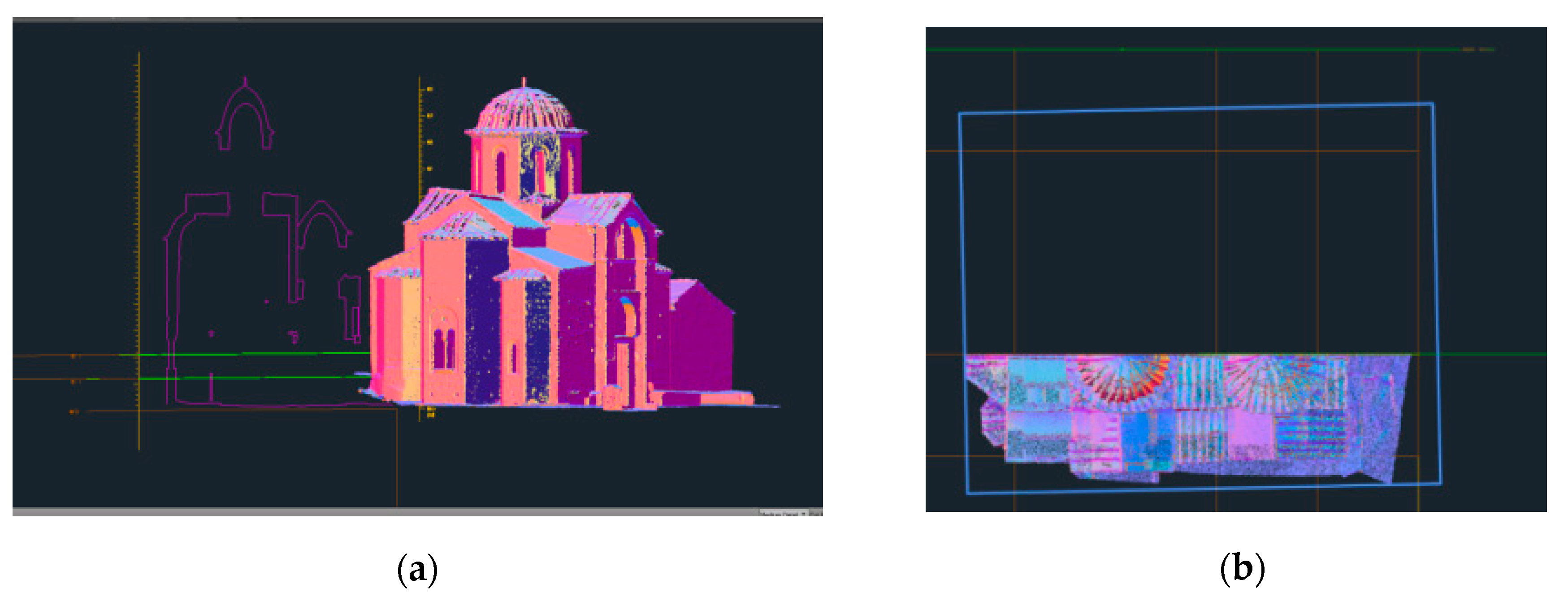
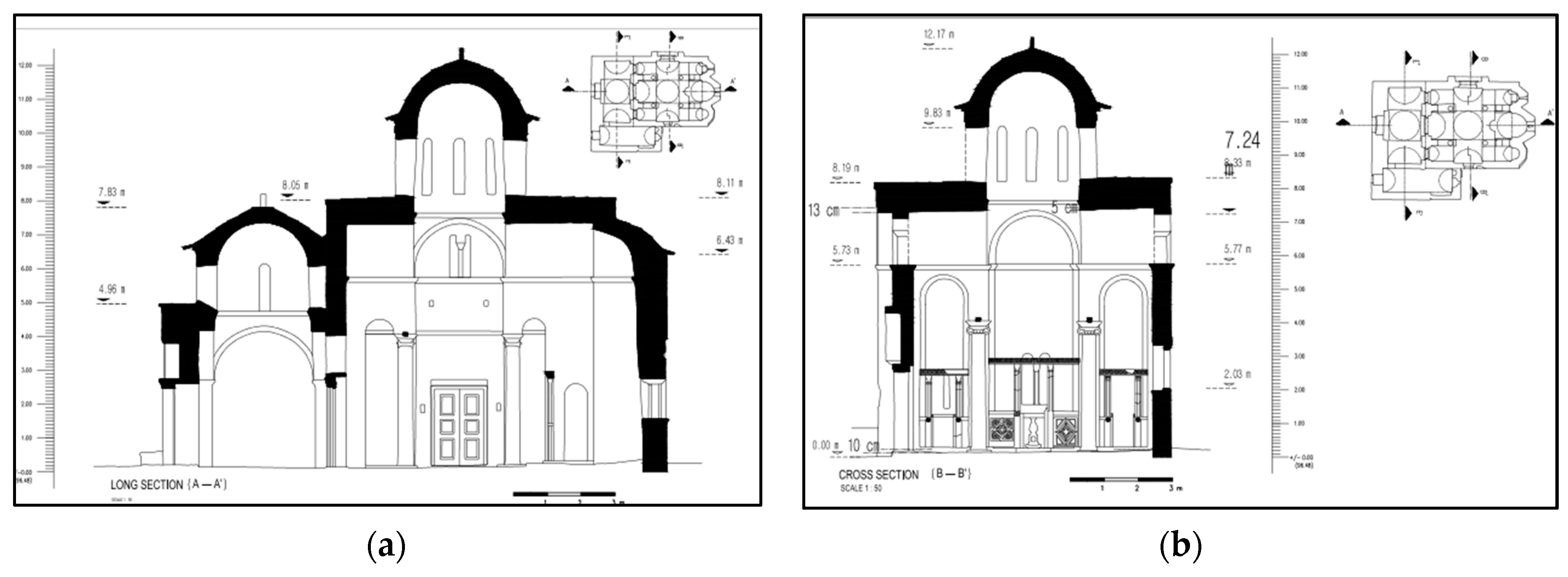
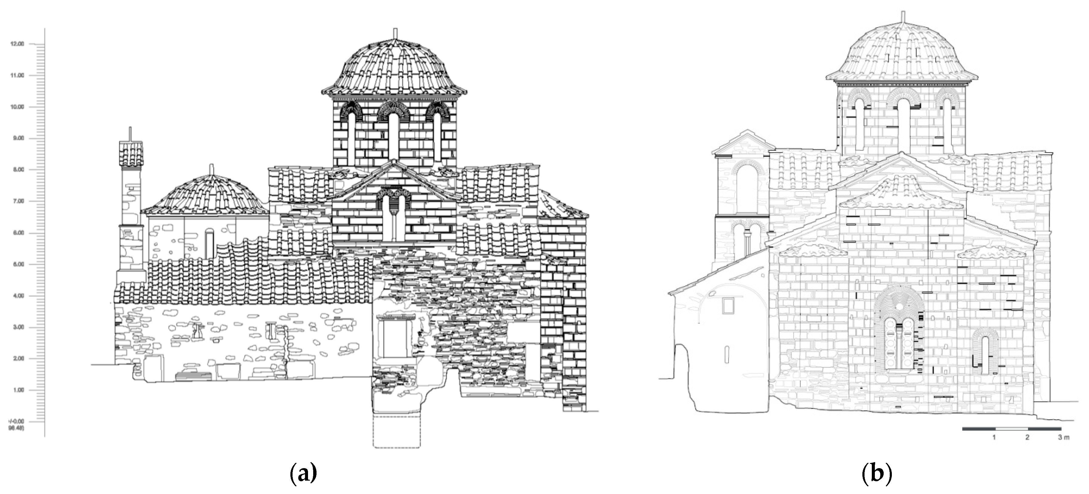
3.1. Geometric Documentation Data
3.2. Historical Documentation Data
3.3. Architectural Documentation Data
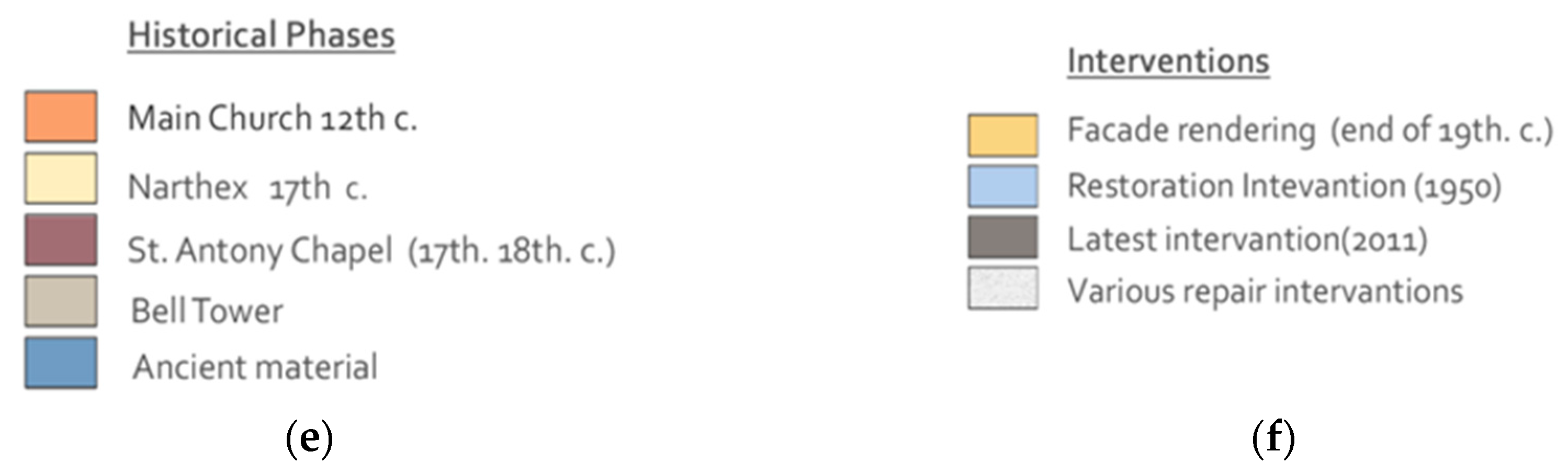
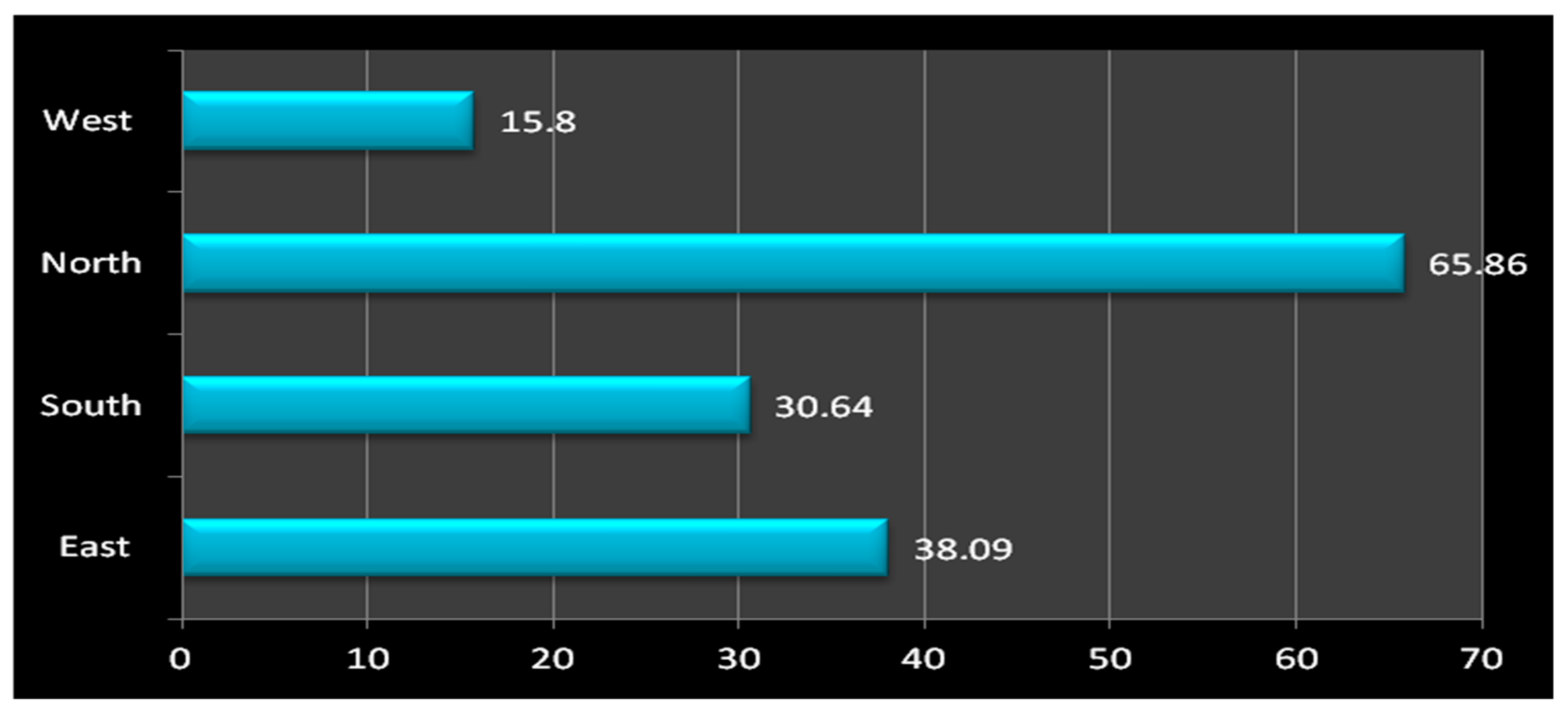
3.4. Building Materials Investigation
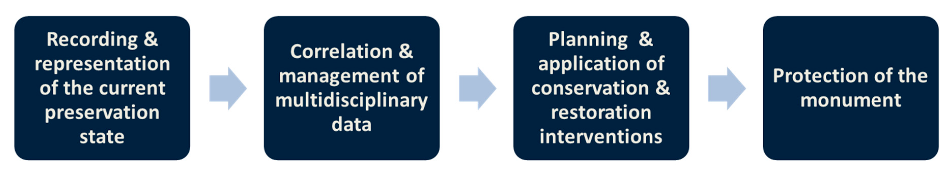
4. Discussion
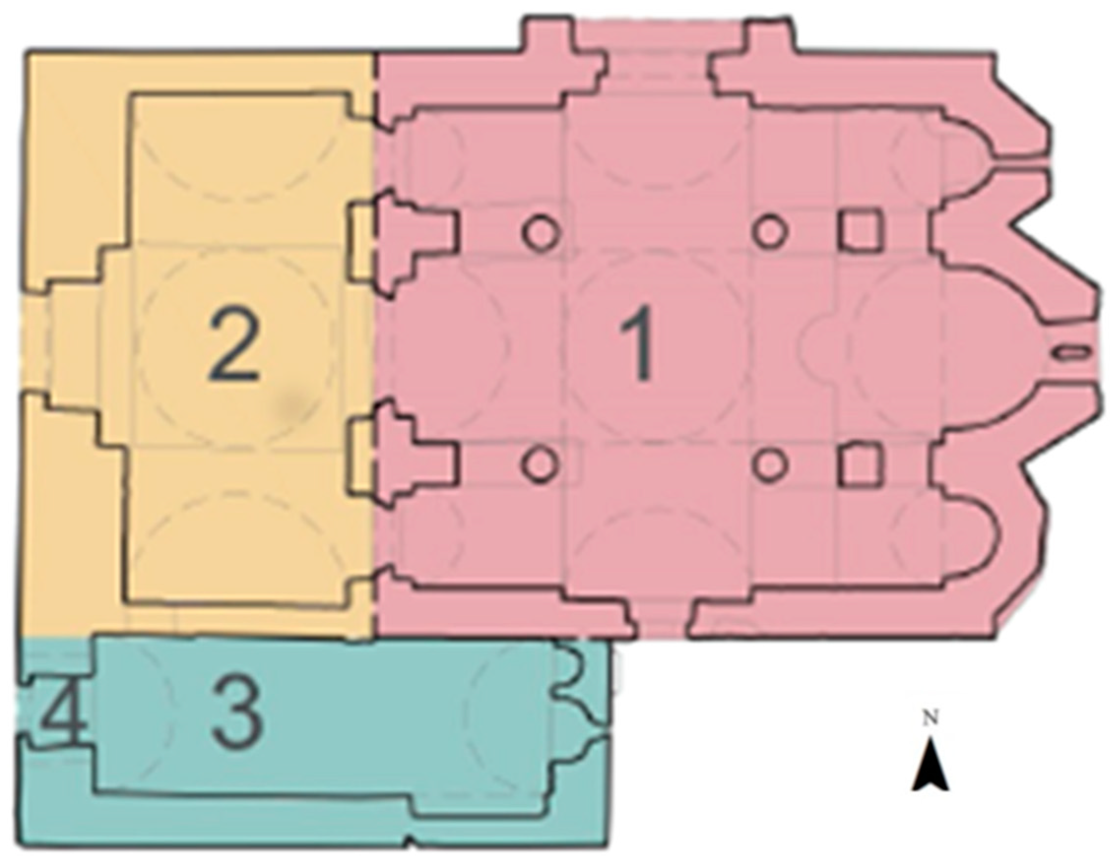
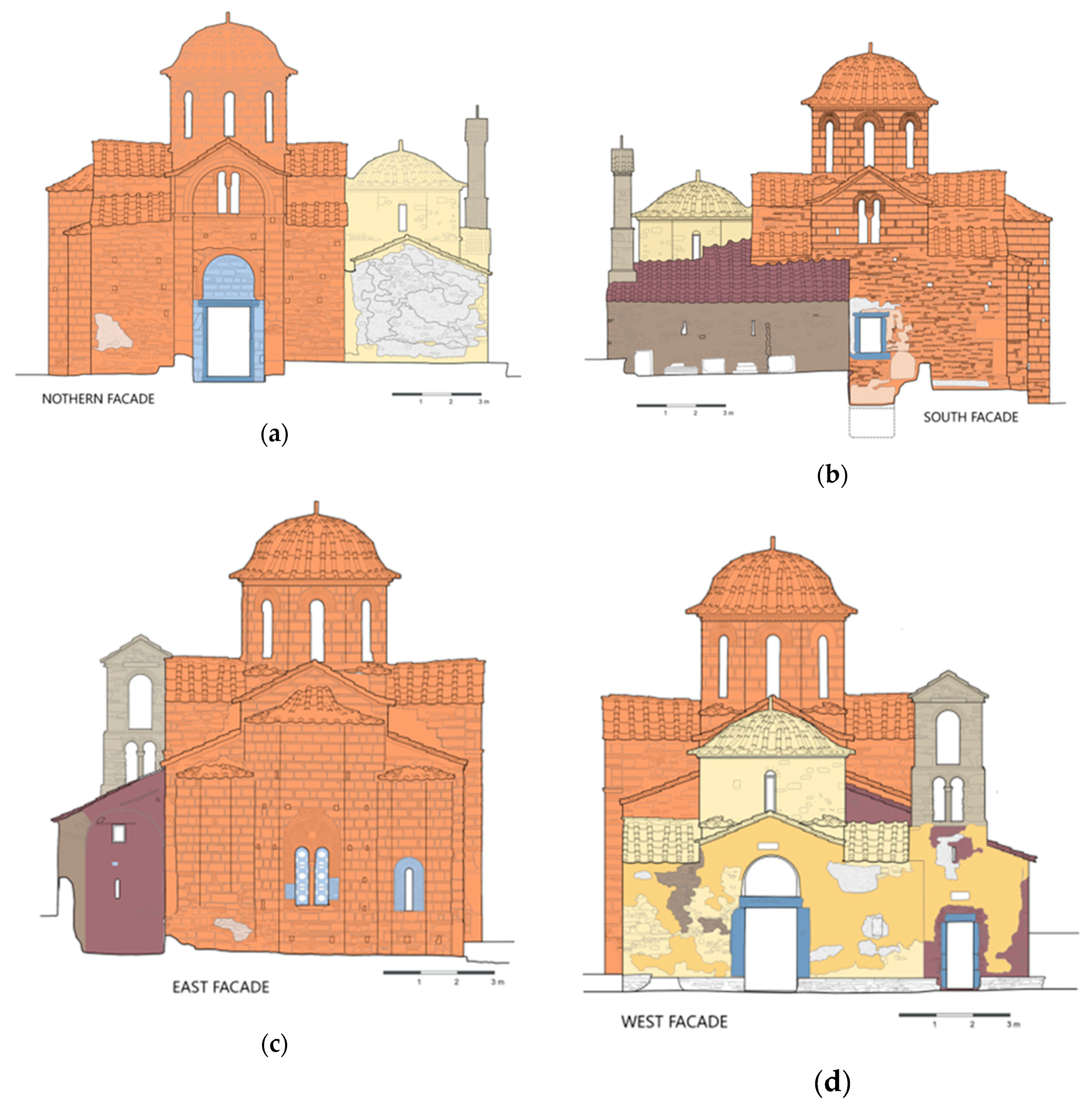
4.1. The Elaboration of the Historical Documentation Towards the Development of Thematic Maps of Construction Phases
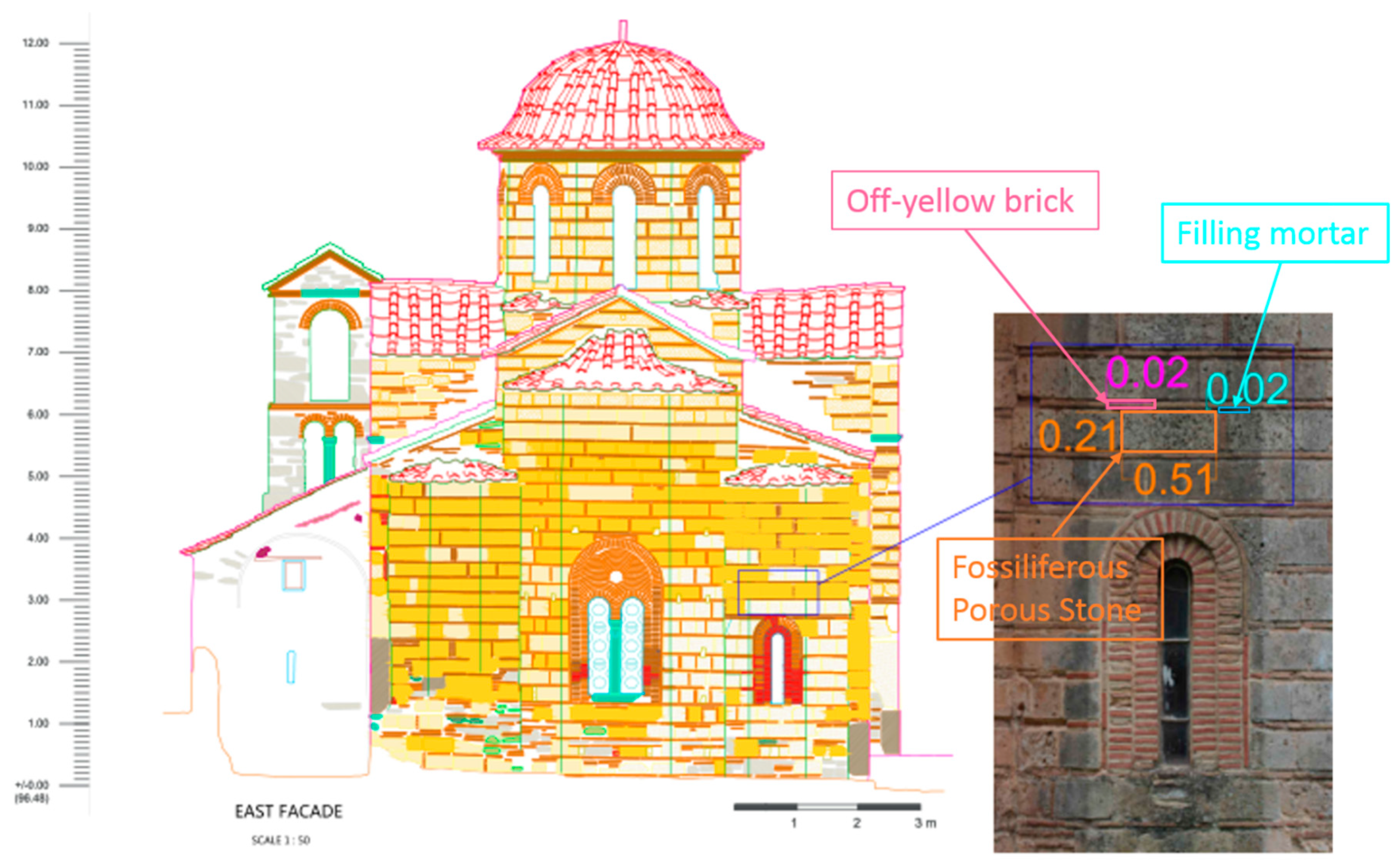
4.2. Elaboration of NDTs for the Development of Thematic Maps
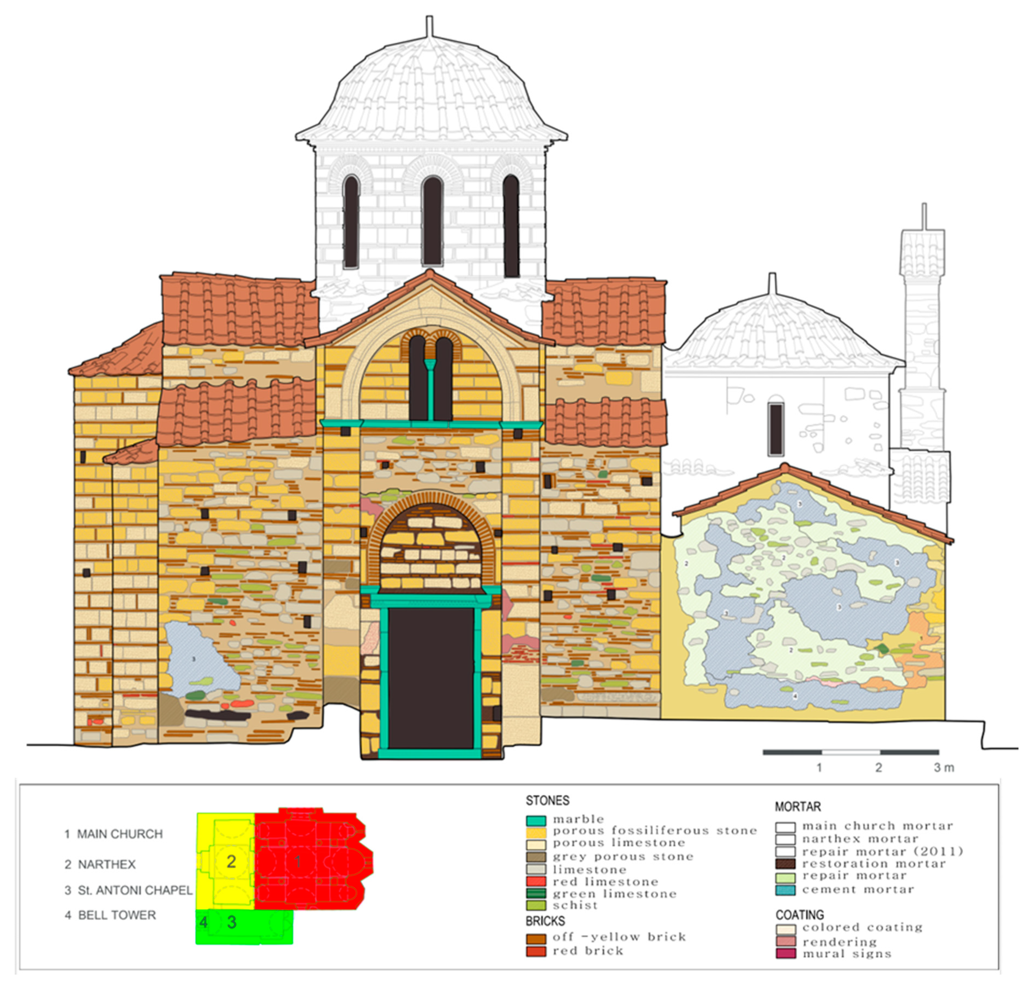
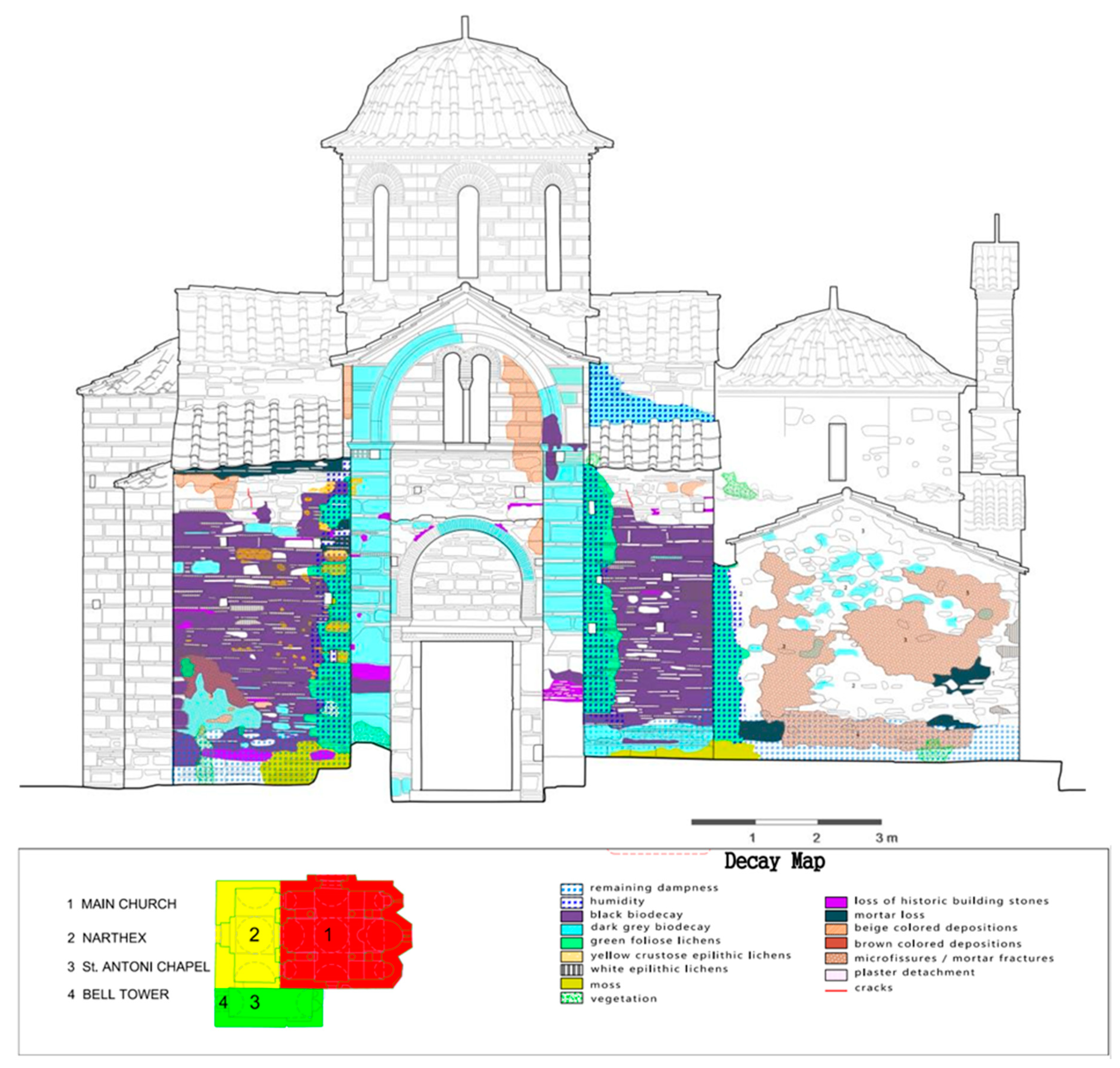
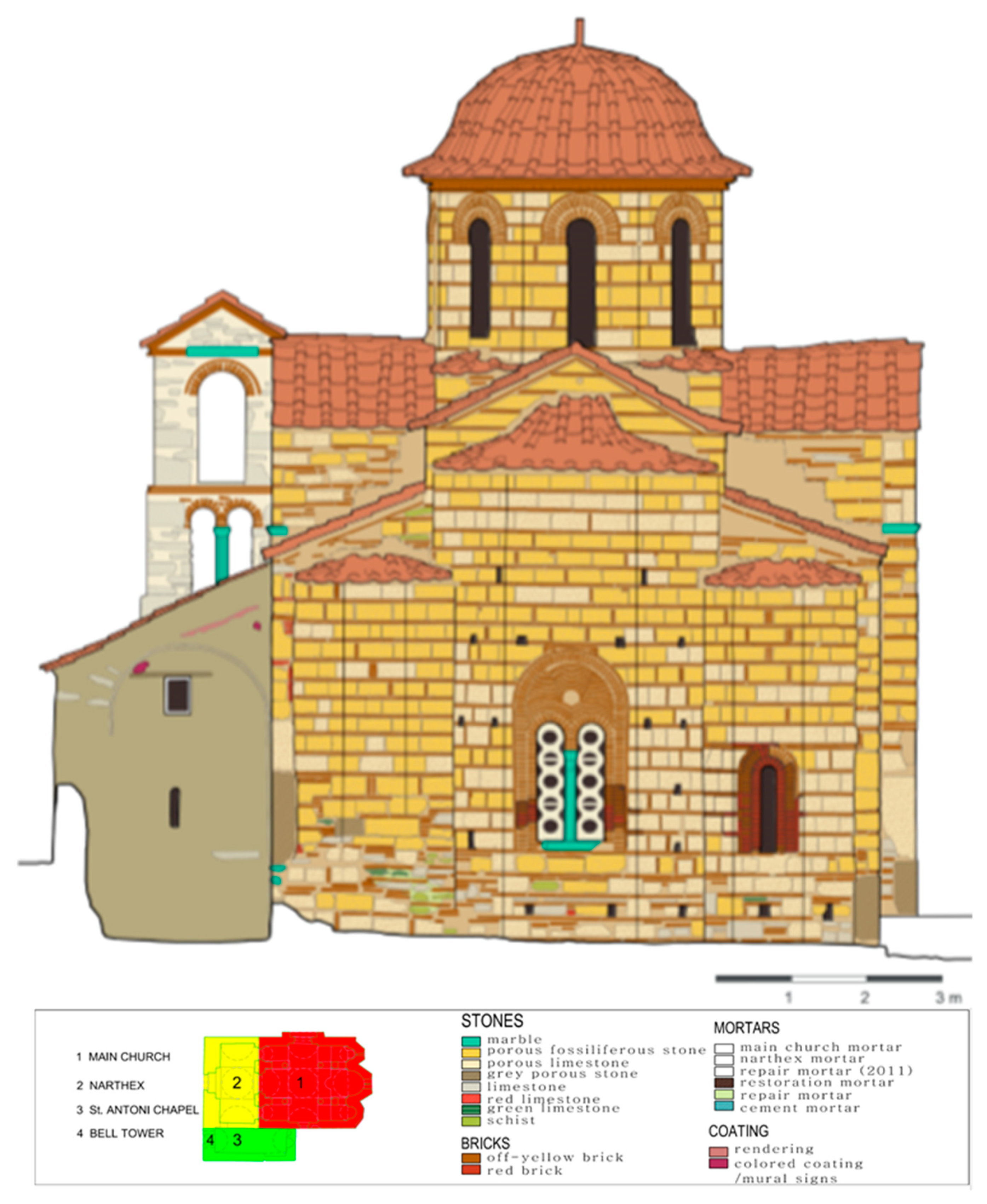
4.3. Thematic Maps of Building Material and Decay
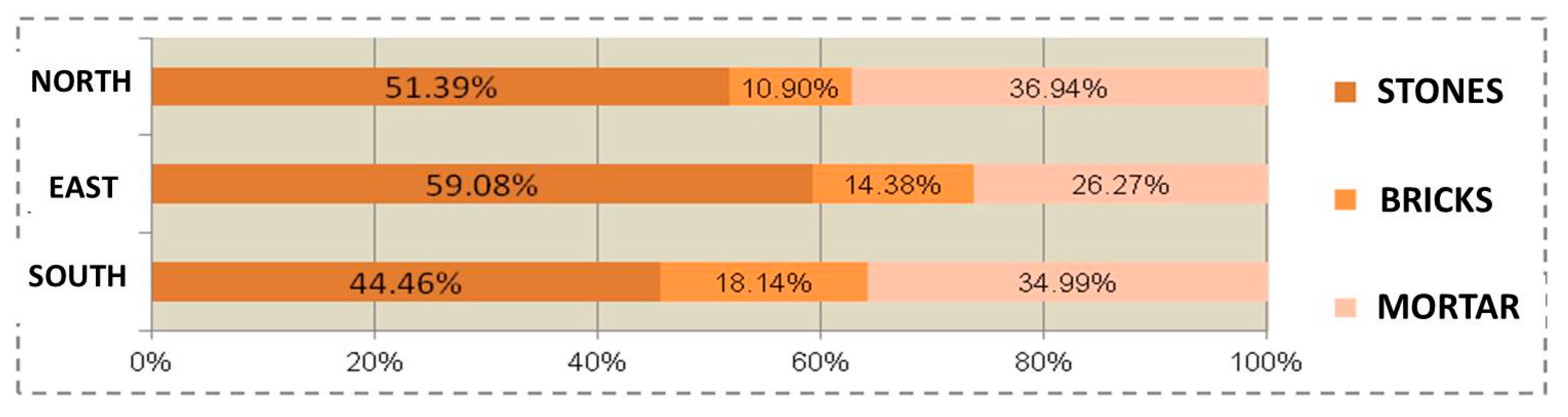
4.4. Quantitative Data Integration
5. Conclusions
Author Contributions
Funding
Acknowledgments
Conflicts of Interest
References
- Moropoulou, A.; Delegou, E.T.; Avdelidis, N.P.; Athanasiadou, A. Integrated diagnostics using advanced in situ measuring technology. In Proceedings of the 10th International Conference on Durability of Building Materials and Components, Lyon, France, 17–20 April 2005; pp. 1116–1123. [Google Scholar]
- Kioussi, A.; Karoglou, M.; Bakolas, A.; Moropoulou, A. Integrated Documentation Protocols Enabling Decision Making in Cultural Heritage Protection. In EuroMed 2012: Progress in Cultural Heritage Preservation; Ioannides, M., Fritsch, D., Leissner, J., Davies, R., Remondino, F., Caffo, R., Eds.; Lecture Notes in Computer Science; Springer: Berlin/Heidelberg, Germany, 2012; Volume 7616. [Google Scholar]
- Letellier, R.; Schmid, W.; LeBlanc, F. Recording, Documentation & Information Management for the Conservation of Heritage Places; Guiding Principles; J. Paul Getty Trust: Los Angeles, CA, USA, 2007. [Google Scholar]
- Salonia, P.; Negri, A. Historical buildings and their decay: Data recording, analysing and transferring in an ITC environment. ISPRS Arch. 2003, 34, 302–306. [Google Scholar]
- Meroño, J.E.; Perea, A.J.; Aguilera, M.J.; Laguna, A.M. Recognition of materials and damage on historical buildings using digital image classification. S. Afr. J. Sci. 2015, 111, 1–9. [Google Scholar] [CrossRef]
- Guidi, G.; Remondino, F. 3D modeling from real data. In Modeling and Simulation in Engineering; Alexandru, C., Ed.; InTech Publisher: Rijeka, Croatia, 2012; pp. 69–102. ISBN 978-953-51-0012-6. [Google Scholar] [CrossRef]
- Kersten, T.P.; Lindstaedt, M. Image-based low-cost systems for automatic 3D recording and modelling of archaeological finds and objects. In EuroMed 2012: Progress in Cultural Heritage Preservation; Ioannides, M., Fritsch, D., Leissner, J., Davies, R., Remondino, F., Caffo, R., Eds.; LNCS; Springer: Berlin/Heidelberg, Germany, 2012; Volume 7616, pp. 1–10. [Google Scholar] [CrossRef]
- Remondino, F. Photogrammetry—Basic Theory. In 3D Recording and Modelling in Archaeology and Cultural Heritage—Theory and Best Practices; Remondino, F., Campana, S., Eds.; Archaeopress BAR Publication Series 2598; Gordon House: Oxford, UK, 2014; pp. 63–72. ISBN 9781407312309. [Google Scholar]
- Gabriele, G.; Danilo, G.; Marco, B. The employment of terrestrial laser scanner in cultural heritage conservation: The case study of Vallinotto Chapel in Carignano-Italy. Appl. Geomat. 2010, 2, 59–63. [Google Scholar] [CrossRef]
- Perez Ramos, A.; Robleda Prieto, G. 3D virtualization by close range photogrammetry indoor gothic church apses. The case study of church of San Francisco in Betanzos (La Coruγ‘a, Spain). ISPRS Int. Arch. Photogramm. Remote Sens. Spat. Inf. Sci. 2015, XL-5/W4, 201–206. [Google Scholar] [CrossRef]
- Boehler, W.; Heinz, G.; Marbs, A. The potential of non-contact close range laser scanners for cultural heritage recording. Int. Arch. Photogramm. Remote Sens. Spat. Inf. Sci. 2010, 34, 430–436. [Google Scholar]
- Costantino, D.; Angelini, M.G.; Baiocchi, V. Photogrammetric Approaches for the Virtual Reconstruction of Damaged Historical Remains. In AVR 2017: Augmented Reality, Virtual Reality, and Computer Graphics; De Paolis, L., Bourdot, P., Mongelli, A., Eds.; Lecture Notes in Computer Science; Springer: Cham, Switzerland, 2017; Volume 10325. [Google Scholar]
- Doulamis, N.; Doulamis, A.; Ioannidis, C.; Klein, M.; Ioannides, M. Modelling of Static and Moving Objects: Digitizing Tangible and Intangible Cultural Heritage; Springer: Cham, Switzerland, 2017. [Google Scholar] [CrossRef]
- Aita, D.; Barsotti, R.; Bennati, S.; Caroti, G.; Piemonte, A. 3-Dimensional Geometric survey and structural modelling of the Dome of Pisa Cathedral. In Proceedings of the International Archives of the Photogrammetry, Remote Sensing and Spatial Information Sciences, 2017 3D Virtual Reconstruction and Visualization of Complex Architectures, Nafplio, Greece, 1–3 March 2017; Volume XLII-2/W3. [Google Scholar]
- Costantino, D.; Angelini, M.G. Qualitative and quantitative evaluation of the luminance of laser scanner radiation for the classification of materials. Int. Arch. Photogramm. Remote Sens. Spatial Inf. Sci. 2013, XL-5/W2, 207–212. [Google Scholar] [CrossRef]
- Hess, M.R.; Petrovic, V.; Kuester, F. Interactive classification of construction materials: Feedback driven framework for annotation and analysis of 3D point clouds. In Proceedings of the 26th International CIPA Symposium, VI, WGVI/4, Ottawa, ON, Canada, 28 August–1 September 2017; pp. 343–347. [Google Scholar]
- Costantino, D.; Angelini, M.G. Three-Dimensional Integrated Survey for Building Investigations. J. Forensic Sci. 2015, 60, 1625–1632. [Google Scholar] [CrossRef] [PubMed]
- Adamopoulos, E.; Tsilimantou, E.; Keramidas, V.; Apostolopoulou, M.; Karoglou, M.; Tapinaki, S.; Ioannidis, C.; Georgopoulos, A.; Moropoulou, A. Multi-sensor documentation of metric and qualitative information of historic stone structures. In Proceedings of the 26th International CIPA Symposium, IV-2/W2, Ottawa, ON, Canada, 28 August–1 September 2017; pp. 1–8. [Google Scholar]
- Moropoulou, A.; Labropoulos, K.C.; Delegou, E.T.; Karoglou, M.; Bakolas, A. Non-Destructive Techniques as a tool for the protection of Built Cultural Heritage. Constr. Build. Mater. 2013, 48, 1222–1239. [Google Scholar] [CrossRef]
- Mourgi, G. Planning and Management of the Diagnostic Study of Material and Decay Patterns for the Katholic of Kaisariani Monastery. Master’s Thesis, National Technical University of Athens, Athens, Greece, 2015. [Google Scholar]
- Charkiolakis, N. The Monasteries of Mount Hymettus, Greece. 7 Days Kathimerini Newspaper (28 September 1997). Available online: http://www.kathimerini.gr/ (accessed on 19 April 2019).
- Strygowsky, J. Kaisariani. Ephemeris Archaiologike. Archaiologike Hetaireia 1902, 41, 51–96. Available online: http://ww2.archetai.gr/images/pdfs/efimeris/Publ_A.E._1902.pdf (accessed on 4 September 2018).
- Genovese, R.A. Architectural, archaeologic and environmental restoration planning methodology: Historic researches and techniques of survey aiming to conservation. Proc. CIPA 2005, 5, 295–299. [Google Scholar]
- Moropoulou, A.; Apostolopoulou, M.; Moundoulas, P.; Karoglou, M.; Delegou, E.; Lampropoulos, K.; Gritsopoulou, M.; Bakolas, A. The combination of NDTS for the diagnostic study of historical buildings: The case study of Kaisariani Monastery. In Proceedings of the COMPDYN 2015 5th ECCOMAS Thematic Conference on Computational Methods in Structural Dynamics and Earthquake Engineering, Crete Island, Greece, 25–27 May 2015; pp. 2321–2336. [Google Scholar]
- Megaw, H. The chronology of some Midle Byzantine churches. Annu. Br. Sch. Athens 1934, 32, 90–130. [Google Scholar] [CrossRef]
- Charalambos Bouras. ‘Byzantine Athens: 10th–12th c. Benaki Museum 6th Supplement, Athens 2010. Available online: https://www.benaki.org/index.php?option=com_publications&view=publication&id=3665&Itemid=584&lang=en (accessed on 19 April 2019).
- Bouras, C.; Boura, L. Greek Religious Architecture in the 12th Century; Greece Commercial Bank of Greece: Athens, Greece, 2002. [Google Scholar]
- Pallis, G. Topography of the Athenian Field during the Post-Byzantine Period; Post-Byzantine Monuments I: Thessalonica, Greece, 2009. [Google Scholar]
- Delegou, E.T.; Tsilimantou, E.; Oikonomopoulou, E.; Sayas, J.; Ioannidis, C.; Moropoulou, A. Mapping of building materials and consevation interventions using GIS: The case of Sarantapicho Acropolis and Erimokastro Acropolis in Rhodes. Int. J. Herit. Digit. Era 2013, 2, 631–653. [Google Scholar] [CrossRef]
- Pelagotti, A.; Mastio, A.D.; De Rosa, A.; Piva, A. Multispectral imaging of paintings: A way to material identification. IEEE Signal Process. Mag. 2008, 25, 27–36. [Google Scholar] [CrossRef]


© 2019 by the authors. Licensee MDPI, Basel, Switzerland. This article is an open access article distributed under the terms and conditions of the Creative Commons Attribution (CC BY) license (http://creativecommons.org/licenses/by/4.0/).
Share and Cite
Delegou, E.T.; Mourgi, G.; Tsilimantou, E.; Ioannidis, C.; Moropoulou, A. A Multidisciplinary Approach for Historic Buildings Diagnosis: The Case Study of the Kaisariani Monastery. Heritage 2019, 2, 1211-1232. https://doi.org/10.3390/heritage2020079
Delegou ET, Mourgi G, Tsilimantou E, Ioannidis C, Moropoulou A. A Multidisciplinary Approach for Historic Buildings Diagnosis: The Case Study of the Kaisariani Monastery. Heritage. 2019; 2(2):1211-1232. https://doi.org/10.3390/heritage2020079
Chicago/Turabian StyleDelegou, Ekaterini T., Georgia Mourgi, Elisavet Tsilimantou, Charalabos Ioannidis, and Antonia Moropoulou. 2019. "A Multidisciplinary Approach for Historic Buildings Diagnosis: The Case Study of the Kaisariani Monastery" Heritage 2, no. 2: 1211-1232. https://doi.org/10.3390/heritage2020079
APA StyleDelegou, E. T., Mourgi, G., Tsilimantou, E., Ioannidis, C., & Moropoulou, A. (2019). A Multidisciplinary Approach for Historic Buildings Diagnosis: The Case Study of the Kaisariani Monastery. Heritage, 2(2), 1211-1232. https://doi.org/10.3390/heritage2020079