Mapping Delayed Canopy Loss and Durable Fire Refugia for the 2020 Wildfires in Washington State Using Multiple Sensors
Abstract
1. Introduction
2. Materials and Methods
2.1. Material Section
2.1.1. Study Area
2.1.2. Image Data
2.2. Methods
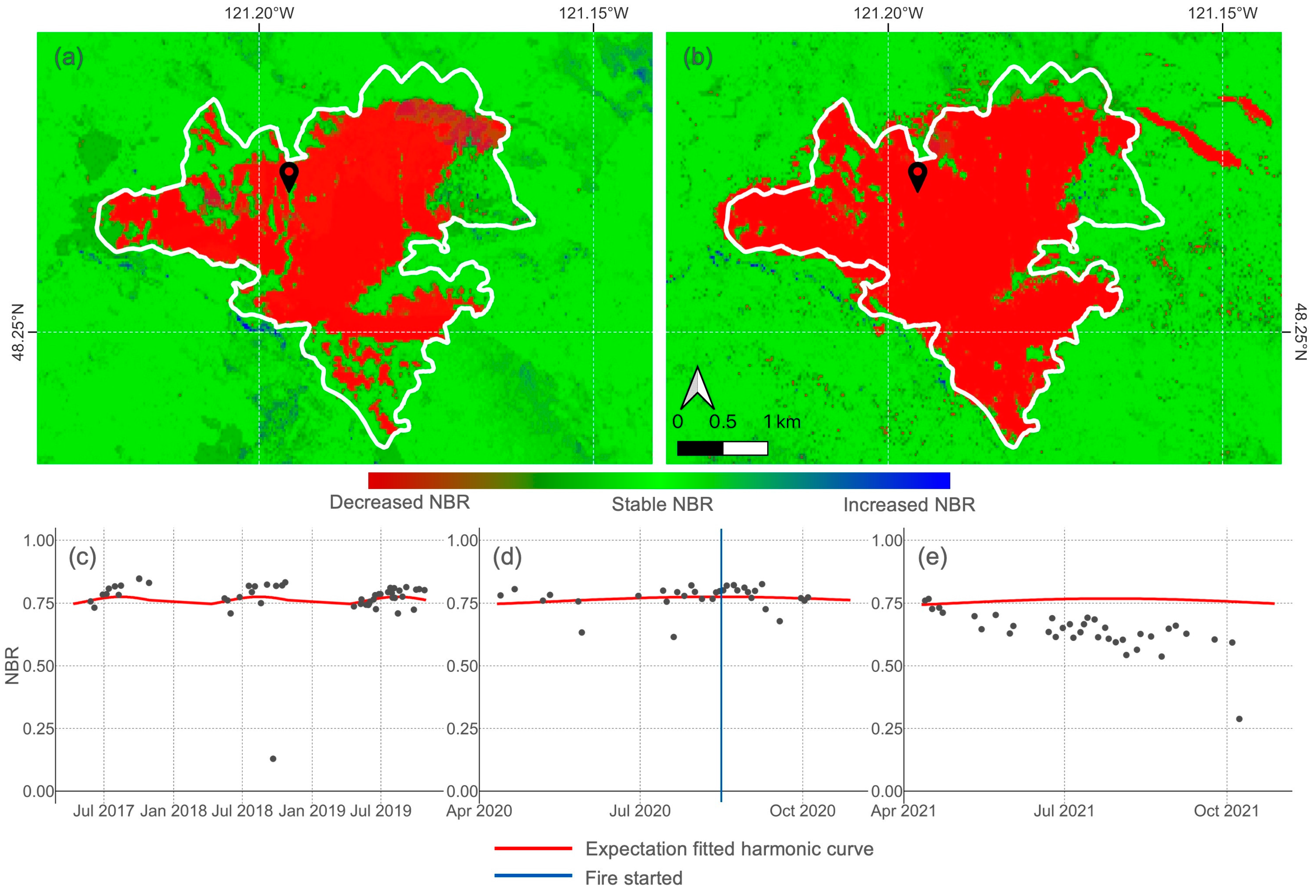
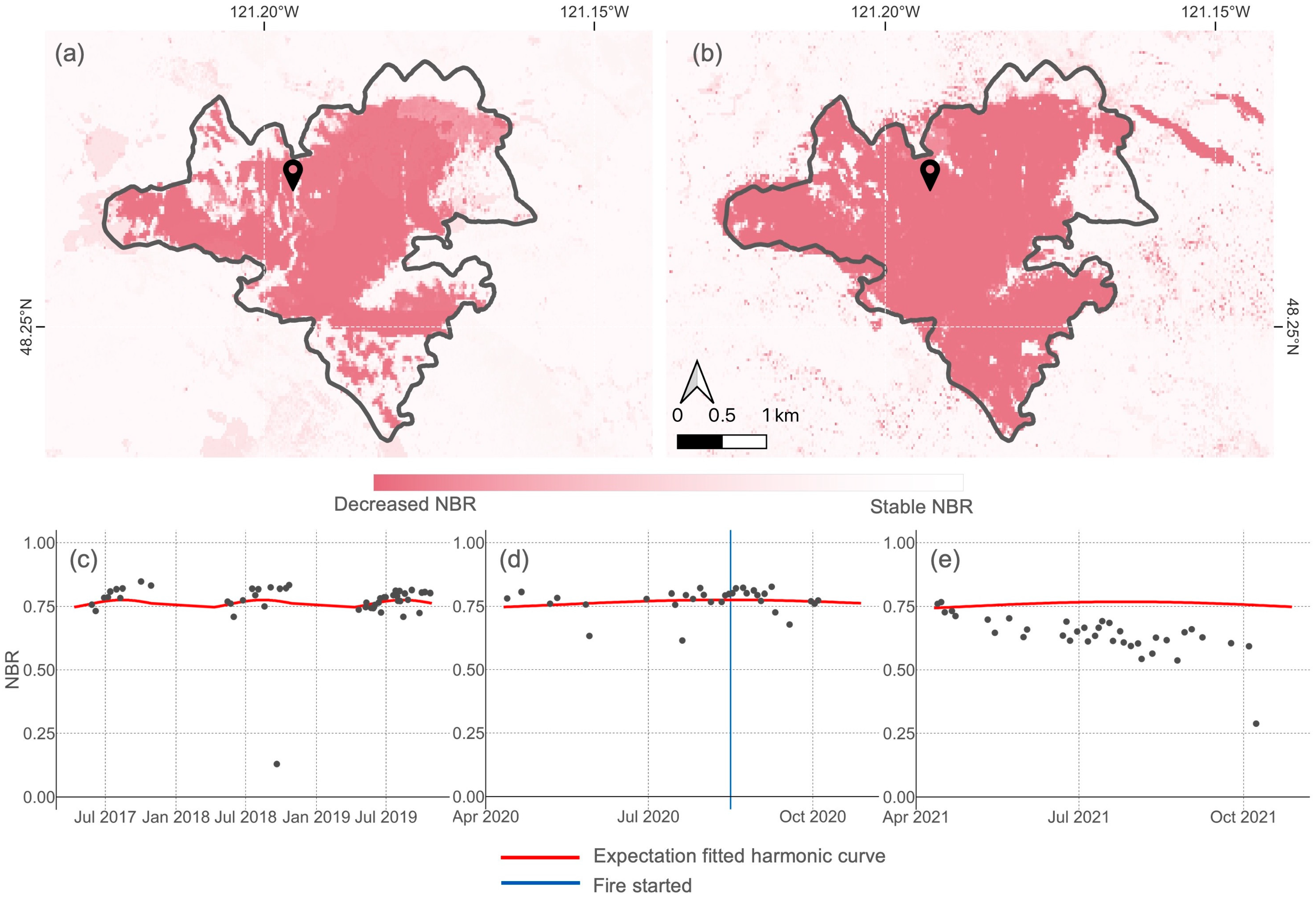
2.2.1. Bayesian Updating of Land Cover (BULC-D)
2.2.2. Mapping Forest Cover Change in the Year of the Fire
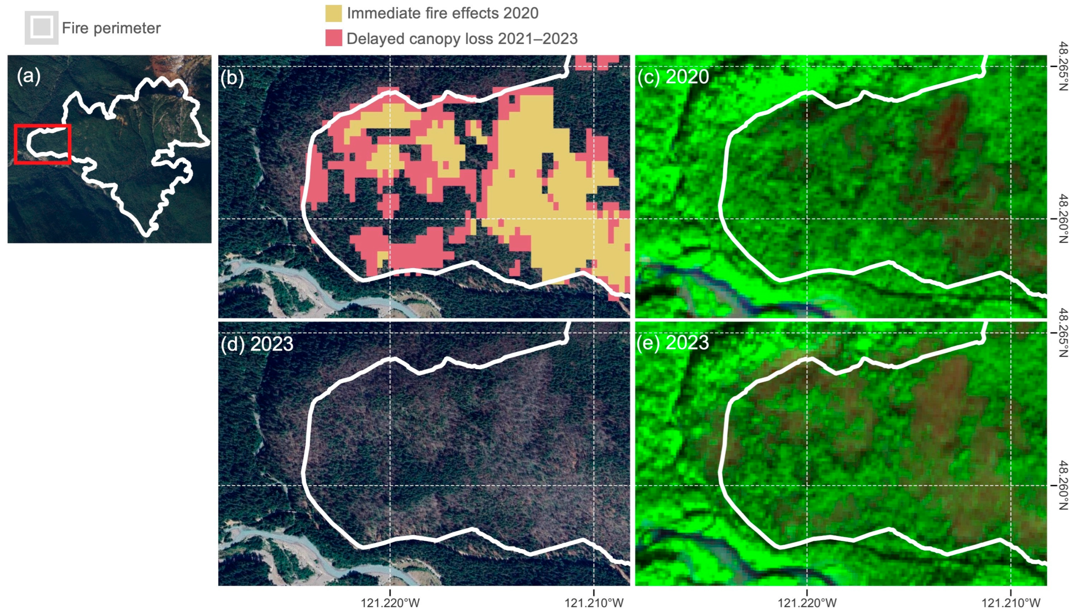
2.2.3. Mapping Delayed Canopy Loss
2.2.4. Mapping Durable Refugia
2.2.5. Accuracy Assessment
3. Results
3.1. Assessment of Burned Maps
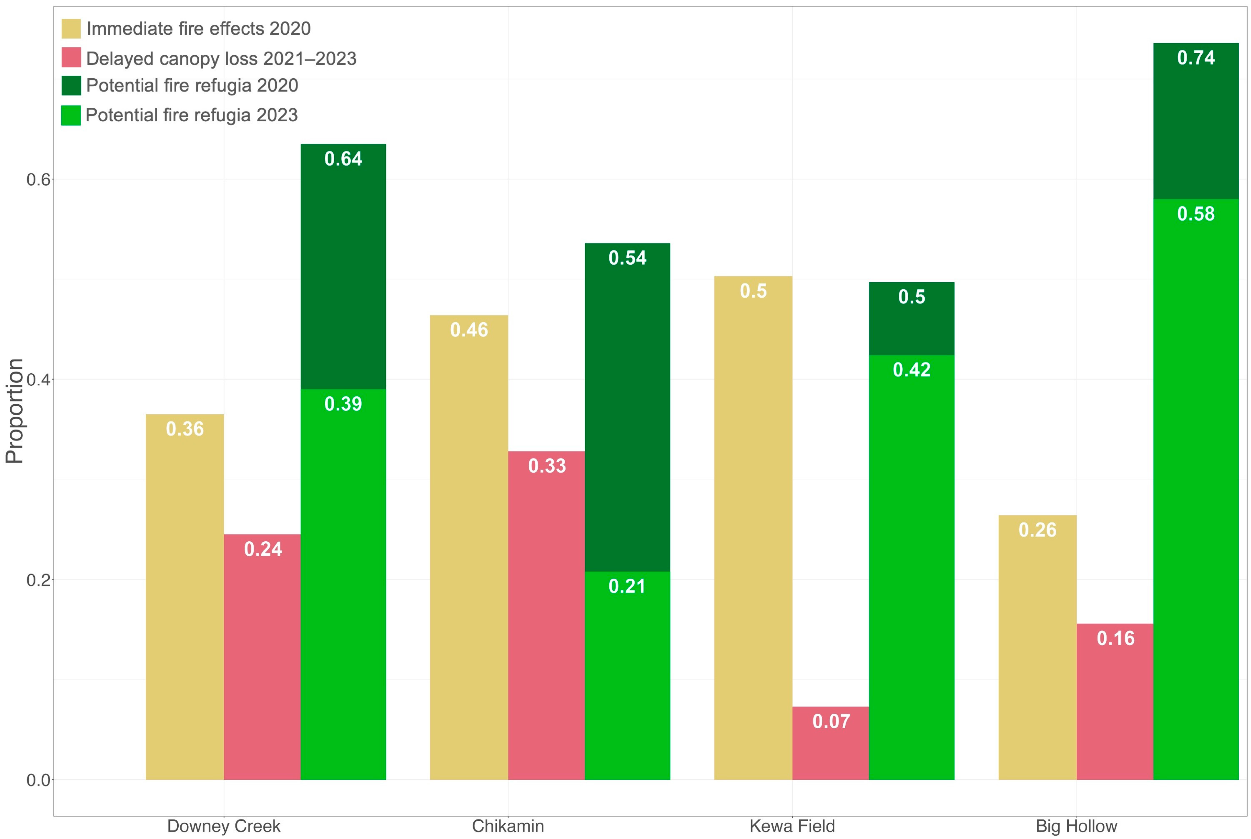
3.2. Maps of Yearly Tree Mortality and Durable Refugia
4. Discussion
4.1. Tracking Delayed Canopy Loss
4.2. Do Fire Refugia Endure in the Years After Fire?
4.3. Observations of Fire Refugia Spatial Patterns
4.4. Limitations
5. Conclusions
Author Contributions
Funding
Institutional Review Board Statement
Informed Consent Statement
Data Availability Statement
Acknowledgments
Conflicts of Interest
Appendix A. Google Earth Engine Scripts
- BULC-D Interface Script
- https://code.earthengine.google.com/?scriptPath=users%2Fanikaanderson%2Fdefault%3ACurrentUse%2Fcopy-BULCD-Interface-v49 (accessed on 1 February 2024)
- Images produced by BULC-D for each year
- https://code.earthengine.google.com/?asset=projects/ee-anikaanderson/assets/NBR35threshold (accessed on 1 May 2024)
- Script for mapping and calculating delayed canopy loss
Appendix B. Supplementary Figures


References
- Higuera, P.E.; Abatzoglou, J.T. Record-Setting Climate Enabled the Extraordinary 2020 Fire Season in the Western United States. Glob. Change Biol. 2021, 27, 1–2. [Google Scholar] [CrossRef] [PubMed]
- Halofsky, J.E.; Peterson, D.L.; Harvey, B.J. Changing Wildfire, Changing Forests: The Effects of Climate Change on Fire Regimes and Vegetation in the Pacific Northwest, USA. Fire Ecol. 2020, 16, 4. [Google Scholar] [CrossRef]
- Johnston, J.D.; Schmidt, M.R.; Merschel, A.G.; Downing, W.M.; Coughlan, M.R.; Lewis, D.G. Exceptional Variability in Historical Fire Regimes across a Western Cascades Landscape, Oregon, USA. Ecosphere 2023, 14, e4735. [Google Scholar] [CrossRef]
- Spies, T.A.; Hessburg, P.F.; Skinner, C.N.; Puettmann, K.J.; Reilly, M.J.; Davis, R.J.; Kertis, J.A.; Long, J.W.; Shaw, D.C. Old Growth, Disturbance, Forest Succession, and Management in the Area of the Northwest Forest Plan. Synth. Sci. Inf. Land Manag. Northwest For. Plan Area 2018, 966, 95–243. [Google Scholar] [CrossRef]
- Stevens, J.T.; Kling, M.M.; Schwilk, D.W.; Varner, J.M.; Kane, J.M. Biogeography of Fire Regimes in Western U.S. Conifer Forests: A Trait-Based Approach. Glob. Ecol. Biogeogr. 2020, 29, 944–955. [Google Scholar] [CrossRef]
- Meddens, A.J.H.; Kolden, C.A.; Lutz, J.A.; Smith, A.M.S.; Cansler, C.A.; Abatzoglou, J.T.; Meigs, G.W.; Downing, W.M.; Krawchuk, M.A. Fire Refugia: What Are They, and Why Do They Matter for Global Change? BioScience 2018, 68, 944–954. [Google Scholar] [CrossRef]
- Busby, S.; Evers, C.; Holz, A. Patterns, Drivers, and Implications of Postfire Delayed Tree Mortality in Temperate Conifer Forests of the Western United States. Ecosphere 2024, 15, e4805. [Google Scholar] [CrossRef]
- Reilly, M.J.; Zuspan, A.; Yang, Z. Characterizing Post-Fire Delayed Tree Mortality with Remote Sensing: Sizing up the Elephant in the Room. Fire Ecol. 2023, 19, 64. [Google Scholar] [CrossRef]
- Key, C.H.; Benson, N.C. Landscape Assessment (LA); USDA Forest Service, Rocky Mountain Research Station: Ogden, UT, USA, 2006. [Google Scholar]
- Miller, J.D.; Thode, A.E. Quantifying Burn Severity in a Heterogeneous Landscape with a Relative Version of the Delta Normalized Burn Ratio (dNBR). Remote Sens. Environ. 2007, 109, 66–80. [Google Scholar] [CrossRef]
- Kennedy, R.E.; Yang, Z.; Cohen, W.B. Detecting Trends in Forest Disturbance and Recovery Using Yearly Landsat Time Series: 1. LandTrendr—Temporal Segmentation Algorithms. Remote Sens. Environ. 2010, 114, 2897–2910. [Google Scholar] [CrossRef]
- Cardil, A.; Mola-Yudego, B.; Blázquez-Casado, Á.; González-Olabarria, J.R. Fire and Burn Severity Assessment: Calibration of Relative Differenced Normalized Burn Ratio (RdNBR) with Field Data. J. Environ. Manag. 2019, 235, 342–349. [Google Scholar] [CrossRef] [PubMed]
- Angers, V.A.; Gauthier, S.; Drapeau, P.; Jayen, K.; Bergeron, Y. Tree Mortality and Snag Dynamics in North American Boreal Tree Species after a Wildfire: A Long-Term Study. Int. J. Wildland Fire 2011, 20, 751–763. [Google Scholar] [CrossRef]
- NASA Earth Science Data Systems. FIRMS Frequently Asked Questions|Earthdata. Available online: https://www.earthdata.nasa.gov/data/tools/firms/faq (accessed on 28 February 2024).
- Blomdahl, E.M.; Kolden, C.A.; Meddens, A.J.H.; Lutz, J.A. The Importance of Small Fire Refugia in the Central Sierra Nevada, California, USA. For. Ecol. Manag. 2019, 432, 1041–1052. [Google Scholar] [CrossRef]
- NASA Earth Science Data Systems. Harmonized Landsat and Sentinel-2 (HLS)|Earthdata. Available online: https://www.earthdata.nasa.gov/esds/harmonized-landsat-sentinel-2 (accessed on 16 October 2023).
- Cardille, J.A.; Fortin, J.A. Bayesian Updating of Land-Cover Estimates in a Data-Rich Environment. Remote Sens. Environ. 2016, 186, 234–249. [Google Scholar] [CrossRef]
- Pelletier, F.; Cardille, J.A.; Wulder, M.A.; White, J.C.; Hermosilla, T. Inter- and Intra-Year Forest Change Detection and Monitoring of Aboveground Biomass Dynamics Using Sentinel-2 and Landsat. Remote Sens. Environ. 2024, 301, 113931. [Google Scholar] [CrossRef]
- Xiong, S.; Baltezar, P.; Crowley, M.A.; Cecil, M.; Crema, S.C.; Baldwin, E.; Cardille, J.A.; Estes, L. Probabilistic Tracking of Annual Cropland Changes over Large, Complex Agricultural Landscapes Using Google Earth Engine. Remote Sens. 2022, 14, 4896. [Google Scholar] [CrossRef]
- Lee, J.; Cardille, J.A.; Coe, M.T. Agricultural Expansion in Mato Grosso from 1986–2000: A Bayesian Time Series Approach to Tracking Past Land Cover Change. Remote Sens. 2020, 12, 688. [Google Scholar] [CrossRef]
- Kolden, C.A.; Lutz, J.A.; Key, C.H.; Kane, J.T.; van Wagtendonk, J.W. Mapped versus Actual Burned Area within Wildfire Perimeters: Characterizing the Unburned. For. Ecol. Manag. 2012, 286, 38–47. [Google Scholar] [CrossRef]
- Meddens, A.J.H.; Kolden, C.A.; Lutz, J.A. Detecting Unburned Areas within Wildfire Perimeters Using Landsat and Ancillary Data across the Northwestern United States. Remote Sens. Environ. 2016, 186, 275–285. [Google Scholar] [CrossRef]
- Mackey, B.; Lindenmayer, D.; Norman, P.; Taylor, C.; Gould, S. Are Fire Refugia Less Predictable Due to Climate Change? Environ. Res. Lett. 2021, 16, 114028. [Google Scholar] [CrossRef]
- Walker, R.B.; Coop, J.D.; Downing, W.M.; Krawchuk, M.A.; Malone, S.L.; Meigs, G.W. How Much Forest Persists Through Fire? High-Resolution Mapping of Tree Cover to Characterize the Abundance and Spatial Pattern of Fire Refugia Across Mosaics of Burn Severity. Forests 2019, 10, 782. [Google Scholar] [CrossRef]
- Lesmeister, D.B.; Davis, R.J.; Sovern, S.G.; Yang, Z. Northern Spotted Owl Nesting Forests as Fire Refugia: A 30-Year Synthesis of Large Wildfires. Fire Ecol. 2021, 17, 32. [Google Scholar] [CrossRef]
- Meigs, G.W.; Dunn, C.J.; Parks, S.A.; Krawchuk, M.A. Influence of Topography and Fuels on Fire Refugia Probability under Varying Fire Weather Conditions in Forests of the Pacific Northwest, USA. Can. J. For. Res. 2020, 50, 636–647. [Google Scholar] [CrossRef]
- Downing, W.M.; Meigs, G.W.; Gregory, M.J.; Krawchuk, M.A. Where and Why Do Conifer Forests Persist in Refugia through Multiple Fire Events? Glob. Change Biol. 2021, 27, 3642–3656. [Google Scholar] [CrossRef]
- Meigs, G.W.; Krawchuk, M.A. Composition and Structure of Forest Fire Refugia: What Are the Ecosystem Legacies across Burned Landscapes? Forests 2018, 9, 243. [Google Scholar] [CrossRef]
- Krawchuk, M.A.; Meigs, G.W.; Cartwright, J.M.; Coop, J.D.; Davis, R.; Holz, A.; Kolden, C.; Meddens, A.J. Disturbance Refugia within Mosaics of Forest Fire, Drought, and Insect Outbreaks. Front. Ecol. Environ. 2020, 18, 235–244. [Google Scholar] [CrossRef]
- National Interagency Fire Center. WFIGS Current Interagency Fire Perimeters. Available online: https://data-nifc.opendata.arcgis.com/datasets/nifc::wfigs-current-interagency-fire-perimeters/about (accessed on 21 September 2023).
- DNR. Ecoregions of the Pacific Northwest. Available online: https://data-wadnr.opendata.arcgis.com/datasets/3b9362e8f29e465a985aa8ddc8de2d86_0/about (accessed on 17 February 2024).
- MTBS Project (USDA Forest Service/U.S. Geological Survey). MTBS Data Access: Burned Areas Boundaries Dataset; USDA Forest Service: Washington, DC, USA, 2021. [Google Scholar]
- Reilly, M.J.; Zuspan, A.; Halofsky, J.S.; Raymond, C.; McEvoy, A.; Dye, A.W.; Donato, D.C.; Kim, J.B.; Potter, B.E.; Walker, N.; et al. Cascadia Burning: The Historic, but Not Historically Unprecedented, 2020 Wildfires in the Pacific Northwest, USA. Ecosphere 2022, 13, e4070. [Google Scholar] [CrossRef]
- Iachetti, P.; Floberg, J.; Wilhere, G.; Ciruna, K.; Markovic, D.; Lewis, J.; Heiner, M.; Kittel, G.; Crawford, R.; Farone, S. North Cascades and Pacific Ranges Ecoregional Assessment, Volume 1-Report; Nature Conservancy of Canada: Victoria, BC, Canada, 2006. [Google Scholar]
- Popper, K.; Wilhere, G.; Schindel, M.; VanderSchaaf, D.; Skidmore, P.; Stroud, G.; Crandall, J.; Kagan, J.; Crawford, R.; Kittel, G. The East Cascades—Modoc Plateau and West Cascades Ecoregional Assessments; The Nature Conservancy: Portland, OR, USA, 2007. [Google Scholar]
- Pryce, B.; Iachetti, P.; Wilhere, G.; Ciruna, K.; Floberg, J.; Crawford, R.; Dye, R.; Fairbarns, M.; Farone, S.; Ford, S. Okanagan Ecoregional Assessment, Volume 1-Report; Nature Conservancy of Canada: Victoria, BC, Canada, 2006. [Google Scholar]
- Chappell, C. North Pacific Dry-Mesic Silver Fir-Western Hemlock-Douglas-Fir Forest|NatureServe Explorer. Available online: https://explorer.natureserve.org/Taxon/ELEMENT_GLOBAL.2.769632/North_Pacific_Dry-Mesic_Silver_Fir-Western_Hemlock-Douglas-fir_Forest (accessed on 1 February 2024).
- Kittel, G.; Chappell, C. North Pacific Maritime Dry-Mesic Douglas-Fir-Western Hemlock Forest|NatureServe Explorer. Available online: https://explorer.natureserve.org/Taxon/ELEMENT_GLOBAL.2.738966/North_Pacific_Maritime_Dry-Mesic_Douglas-fir-Western_Hemlock_Forest (accessed on 1 February 2024).
- Northern Rocky Mountain Dry-Mesic Montane Mixed Conifer Forest|NatureServe Explorer. Available online: https://explorer.natureserve.org/Taxon/ELEMENT_GLOBAL.2.722868/Northern_Rocky_Mountain_Dry-Mesic_Montane_Mixed_Conifer_Forest (accessed on 1 February 2024).
- Rocky Mountain Subalpine Mesic-Wet Spruce-Fir Forest and Woodland|NatureServe Explorer. Available online: https://explorer.natureserve.org/Taxon/ELEMENT_GLOBAL.2.722843/Rocky_Mountain_Subalpine_Mesic-Wet_Spruce-Fir_Forest_and_Woodland (accessed on 1 February 2024).
- Hood, S.M.; Harvey, B.J.; Fornwalt, P.J.; Naficy, C.E.; Hansen, W.D.; Davis, K.T.; Battaglia, M.A.; Stevens-Rumann, C.S.; Saab, V.A. Fire Ecology of Rocky Mountain Forests. In Fire Ecology and Management: Past, Present, and Future of US Forested Ecosystems; Greenberg, C.H., Collins, B., Eds.; Managing Forest Ecosystems; Springer International Publishing: Cham, Switzerland, 2021; Volume 39, pp. 287–336. ISBN 978-3-030-73266-0. [Google Scholar]
- Geological Survey; USDA LANDFIRE: LANDFIRE Existing Vegetation Type Layer. Available online: https://www.landfire.gov/viewer/ (accessed on 1 May 2023).
- Gorelick, N.; Hancher, M.; Dixon, M.; Ilyushchenko, S.; Thau, D.; Moore, R. Google Earth Engine: Planetary-Scale Geospatial Analysis for Everyone. Remote Sens. Environ. 2017, 202, 18–27. [Google Scholar] [CrossRef]
- Braaten, J.; Schwehr, K.; Ilyushchenko, S. More Accurate and Flexible Cloud Masking for Sentinel-2 Images. Google Earth Earth Engine 2020. [Google Scholar]
- Fortin, J.A.; Cardille, J.A.; Perez, E. Multi-Sensor Detection of Forest-Cover Change across 45 Years in Mato Grosso, Brazil. Remote Sens. Environ. 2020, 238, 111266. [Google Scholar] [CrossRef]
- USFS Mt. Baker-Snoqualmie National Forest—Alerts & Closures. Available online: https://www.fs.usda.gov/wps/portal/fsinternet3/cs/detail/mbs/alerts-notices/ (accessed on 30 January 2024).
- Prestemon, J.P.; Holmes, T.P. Timber Salvage Economics. The Economics of Forest Disturbances: Wildfires, Storms, and Invasive Species; Springer: Berlin/Heidelberg, Germany, 2008; pp. 167–190. [Google Scholar]
- Olofsson, P.; Foody, G.M.; Herold, M.; Stehman, S.V.; Woodcock, C.E.; Wulder, M.A. Good Practices for Estimating Area and Assessing Accuracy of Land Change. Remote Sens. Environ. 2014, 148, 42–57. [Google Scholar] [CrossRef]
- Stehman, S.V. Estimating Area and Map Accuracy for Stratified Random Sampling When the Strata Are Different from the Map Classes. Int. J. Remote Sens. 2014, 35, 4923–4939. [Google Scholar] [CrossRef]
- Incident Table. Available online: http://inciweb.nwcg.gov/accessible-view (accessed on 30 March 2023).
- Dyer, A.S.; Busby, S.; Evers, C.; Reilly, M.; Zuspan, A.; Holz, A. Post-Fire Delayed Tree Mortality in Mesic Coniferous Forests Reduces Fire Refugia and Seed Sources. Landsc. Ecol. 2025, 40, 101. [Google Scholar] [CrossRef]
- Confederated Tribes of the Colville Reservation Forestry—Kewa Fields Fire Salvage Map. Available online: https://www.colvilletribes.com/forestry (accessed on 31 October 2023).
- Okanogan-Wenatchee National Forest—Alerts & Closures. Available online: https://www.fs.usda.gov/wps/portal/fsinternet3/cs/detail/okawen/alerts-notices/ (accessed on 31 October 2023).
- Wildfire Division. Wildfire Season 2020; Washington Department of Natural Resources: Washington, DC, USA, 2020. [Google Scholar]
- Krawchuk, M.A.; Haire, S.L.; Coop, J.; Parisien, M.-A.; Whitman, E.; Chong, G.; Miller, C. Topographic and Fire Weather Controls of Fire Refugia in Forested Ecosystems of Northwestern North America. Ecosphere 2016, 7, e01632. [Google Scholar] [CrossRef]
- European Space Agency. Spatial—Resolutions—Sentinel-2 MSI—User Guides—Sentinel Online. Available online: https://copernicus.eu/user-guides/sentinel-2-msi/resolutions/spatial (accessed on 2 April 2023).


| Fire | Start Date | Area Within National Interagency Fire Center Perimeter (ha) | MTBS Burn Severity | |||
|---|---|---|---|---|---|---|
| Unburned to Low | Low | Moderate | High | |||
| Big Hollow Fire | 8 September 2020 | 9814 | 2076 | 4356 | 1508 | 1874 |
| Chikamin Fire | 31 July 2020 | 786 | 79 | 242 | 282 | 183 |
| Downey Creek Fire | 16 August 2020 | 937 | 200 | 236 | 221 | 280 |
| Kewa Field Fire | 7 September 2020 | 4 776 | 631 | 2934 | 860 | 351 |
| Reference | ||||||
|---|---|---|---|---|---|---|
| Unburned | Burned | Total | User’s Accuracy | Producer’s Accuracy | Overall Accuracy | |
| Unburned | 0.427 | 0.091 | 0.518 | 0.825 ± 0.030 | 0.985 ± 0.007 | 0.903 ± 0.016 |
| Burned | 0.006 | 0.475 | 0.482 | 0.987 ± 0.006 | 0.839 ± 0.023 | |
| Total | 0.434 | 0.566 | 1.000 |
| Reference | ||||||
|---|---|---|---|---|---|---|
| Immediate Fire Effects | Delayed Canopy Loss | Total | User’s Accuracy | Producer’s Accuracy | Overall Accuracy | |
| Immediate fire effects | 0.663 | 0.028 | 0.691 | 0.960 ± 0.020 | 0.849 ± 0.016 | 0.854 ± 0.020 |
| Delayed canopy loss | 0.118 | 0.191 | 0.309 | 0.619 ± 0.046 | 0.873 ± 0.055 | |
| Total | 0.781 | 0.219 | 1.000 |
Disclaimer/Publisher’s Note: The statements, opinions and data contained in all publications are solely those of the individual author(s) and contributor(s) and not of MDPI and/or the editor(s). MDPI and/or the editor(s) disclaim responsibility for any injury to people or property resulting from any ideas, methods, instructions or products referred to in the content. |
© 2025 by the authors. Licensee MDPI, Basel, Switzerland. This article is an open access article distributed under the terms and conditions of the Creative Commons Attribution (CC BY) license (https://creativecommons.org/licenses/by/4.0/).
Share and Cite
Anderson, A.M.; Krawchuk, M.A.; Pelletier, F.; Cardille, J.A. Mapping Delayed Canopy Loss and Durable Fire Refugia for the 2020 Wildfires in Washington State Using Multiple Sensors. Fire 2025, 8, 230. https://doi.org/10.3390/fire8060230
Anderson AM, Krawchuk MA, Pelletier F, Cardille JA. Mapping Delayed Canopy Loss and Durable Fire Refugia for the 2020 Wildfires in Washington State Using Multiple Sensors. Fire. 2025; 8(6):230. https://doi.org/10.3390/fire8060230
Chicago/Turabian StyleAnderson, Anika M., Meg A. Krawchuk, Flavie Pelletier, and Jeffrey A. Cardille. 2025. "Mapping Delayed Canopy Loss and Durable Fire Refugia for the 2020 Wildfires in Washington State Using Multiple Sensors" Fire 8, no. 6: 230. https://doi.org/10.3390/fire8060230
APA StyleAnderson, A. M., Krawchuk, M. A., Pelletier, F., & Cardille, J. A. (2025). Mapping Delayed Canopy Loss and Durable Fire Refugia for the 2020 Wildfires in Washington State Using Multiple Sensors. Fire, 8(6), 230. https://doi.org/10.3390/fire8060230


