Article

Wildfire Risk Assessment in Ambato, Ecuador: Drought Impacts, Fuel Dynamics, and Wildland–Urban Interface Vulnerability

by
Andrés Hidalgo
1,
Luis Contreras-Vásquez
2,*,
Verónica Nuñez
3 and
Bolivar Paredes-Beltran
1
1
Carrera de Ingeniería Civil, Facultad de Ingeniería Civil y Mecánica, Universidad Técnica de Ambato, Ambato 180206, Ecuador
2
Faculty of Civil and Mechanical Engineering, Research and Development Directorate, Universidad Técnica de Ambato, Ambato 180206, Ecuador
3
H. Gobierno Provincial de Tungurahua, Ambato 180103, Ecuador
*
Author to whom correspondence should be addressed.
Fire 2025, 8(4), 130; https://doi.org/10.3390/fire8040130
Submission received: 18 February 2025 / Revised: 21 March 2025 / Accepted: 25 March 2025 / Published: 27 March 2025

Abstract

:
Wildfires represent an increasing threat to ecosystems and communities, driven by climate change, fuel dynamics, and human activities. In Ambato, Ecuador, a city in the Andean highlands, these risks are exacerbated by prolonged droughts, vegetation dryness, and urban expansion into fire-prone areas within the Wildland–Urban Interface (WUI). This study integrates climatic, ecological, and socio-economic data from 2017 to 2023 to assess wildfire risks, employing advanced geospatial tools, thematic mapping, and machine learning models, including Multinomial Logistic Regression (MLR), Random Forest, and XGBoost. By segmenting the study area into 1 km2 grid cells, microscale risk variations were captured, enabling classification into five categories: ‘Very Low’, ‘Low’, ‘Moderate’, ‘High’, and ‘Very High’. Results indicate that temperature anomalies, reduced fuel moisture, and anthropogenic factors such as waste burning and unregulated land-use changes significantly increase fire susceptibility. Predictive models achieved accuracies of 76.04% (MLR), 77.6% (Random Forest), and 76.5% (XGBoost), effectively identifying high-risk zones. The highest-risk areas were found in Izamba, Pasa, and San Fernando, where over 884.9 ha were burned between 2017 and 2023. The year 2020 recorded the most severe wildfire season (1500 ha burned), coinciding with extended droughts and COVID-19 lockdowns. Findings emphasize the urgent need for enhanced land-use regulations, improved firefighting infrastructure, and community-driven prevention strategies. This research provides a replicable framework for wildfire risk assessment, applicable to other Andean regions and beyond. By integrating data-driven methodologies with policy recommendations, this study contributes to evidence-based wildfire mitigation and resilience planning in climate-sensitive environments.

1. Introduction

Wildfires represent a growing environmental and socio-economic challenge for the 21st century, exacerbated by climate change, land-use changes, and human activities. In recent decades, there has been a global rise in the frequency and intensity of wildfires, especially in areas susceptible to extended droughts, high temperatures, and irregular precipitation patterns [1,2,3,4,5]. These climatic stressors accelerate vegetative dryness, augmenting fuel loads and elevating the likelihood of ignition [6,7,8]. Additionally, anthropogenic factors, such as urban expansion into fire-prone areas, agricultural burning, and inadequate land management practices, have significantly contributed to wildfire outbreaks [9,10,11,12]. The Wildland–Urban Interface (WUI) has emerged as a critical area for fire danger, where natural ecosystems and human populations converge, increasing susceptibility [4,10,11,13,14,15].
Ambato, located in the Andean highlands of Ecuador, is increasingly threatened by wildfires as a result of climate variability and anthropogenic pressures [16,17,18]. The region has experienced more frequent and prolonged droughts, intensifying fuel accumulation and ignition potential [18,19,20,21,22]. At the same time, urban expansion into fire-prone zones, combined with slash-and-burn agricultural practices and waste burning, has aggravated fire risks [4,9,10,14,23,24]. The absence of comprehensive risk evaluations for this region hinders the implementation of effective mitigation methods [17,18,22]. Therefore, a comprehensive, data-driven analysis is necessary to evaluate fire susceptibility, incorporating climatic, ecological, and socio-economic variables to enhance risk prediction and inform policy decisions [2,11,25]. Several studies have explored wildfire risk assessment using different methodologies, including geospatial analysis, remote sensing, and machine learning models [25,26,27,28,29,30,31,32]. Recent research has shown that climatic factors, including temperature anomalies, drought indices, and precipitation variability, substantially affect wildfire vulnerability [5,33,34,35,36,37,38]. Land-use alterations, fuel accumulation, and anthropogenic activities, especially within the Wildland–Urban Interface (WUI), have been recognized as significant factors in fire ignition and propagation [10,11,12,14]. Improvements in machine learning methodologies, including Random Forest, XGBoost, and logistic regression models, have enhanced wildfire prediction through the integration of spatial, environmental, and socio-economic datasets [25,28,32]. However, despite these advancements, most of these numerous studies have focused on ecosystems different from the high-altitude Andean regions, leaving these kinds of regions with limited wildfire risk assessments [13,15,33,39,40,41,42,43,44].
In Ecuador, few studies have systematically analyzed wildfire risks using integrated machine learning approaches and high-resolution geospatial data [17,18]. The existing research mainly focuses on broad-scale climatic influences rather than incorporating local-scale anthropogenic drivers and microclimatic variations. Additionally, the lack of comprehensive wildfire databases and standardized risk models hinders the development of evidence-based mitigation policies [17]. Therefore, this study aims to fill this gap by combining climatic, ecological, and socio-economic data with advanced geospatial tools and machine learning algorithms, providing a framework for assessing wildfire risk that is replicable for Ambato and other Andean regions. Ambato, located in the Andean highlands of Ecuador, has experienced an increasing frequency of wildfires in recent years, exacerbated by climatic variability, fuel accumulation, and anthropogenic activities [18,19,22]. The region’s distinct topographic and climatic characteristics, including prolonged droughts, seasonal temperature anomalies, and strong winds, contribute to vegetation dryness and high fire susceptibility [16,20,21]. Furthermore, the construction of additional cities in fire-prone regions, particularly along the Wildland–Urban Interface (WUI), has exacerbated the danger of wildfires by increasing potential ignition sites and eliminating natural firebreaks [19]. Despite these escalating threats, Ambato lacks a comprehensive framework for assessing wildfire risk that integrates climatic, ecological, and socio-economic factors. Current research in Ecuador has predominantly concentrated on overarching climate trends, neglecting to address localized fluctuations in fire risk dynamics at the microscale [17,18]. This study seeks to address the identified research gap by employing a data-driven methodology for wildfire risk assessment, utilizing sophisticated geospatial analysis, thematic mapping, and machine learning algorithms to produce a high-resolution risk categorization for Ambato. The findings will contribute to evidence-based policymaking and the development of targeted mitigation strategies for high-risk areas. This study employs geospatial analysis, climatic data processing, and machine learning approaches to precisely evaluate wildfire risk in Ambato, resulting in a high-resolution wildfire risk categorization. The methodological framework has three essential components: (1) Spatial analysis employing Geographic Information Systems (GIS) to investigate the interaction among climatic, ecological, and anthropogenic factors; (2) predictive modeling utilizing machine learning algorithms, such as multinomial logistic regression (MLR), random forests, and XGBoost, to categorize risk levels and pinpoint high-risk areas; and (3) thematic mapping to illustrate risk distribution and facilitate data-informed decision-making.
The study region was divided into 1 km2 grid cells, facilitating the detection of minor variations in risk within the Wildland–Urban Interface (WUI). Climatic factors, including temperature, precipitation, wind speed, and humidity, were integrated with land-use classifications, vegetation indices (NDVI), and population density data to develop a comprehensive wildfire susceptibility model. The predictive models were developed and verified utilizing historical wildfire data (2017–2023), facilitating an evaluation of fire-prone regions under varying climatic and environmental conditions. This integrative methodology improves the precision of wildfire risk mapping and offers a scientifically sound framework for policymakers and emergency response planners in Ambato.
This study’s methodological approach emphasizes the necessity of combining advanced analytical methods with localized data to improve wildfire risk assessments in intricate Andean terrain. By leveraging machine learning, geospatial analysis, and thematic mapping, this research provides a systematic and adaptable framework for wildfire prediction and mitigation. This holistic approach ensures that risk assessments remain responsive to evolving climatic conditions and urbanization trends, fostering long-term resilience in Ambato and other wildfire-prone regions.

2. Materials and Methods

2.1. Study Area

Ambato is a city located in the Andean highlands of Ecuador (01°14′ S, 78°37′ W), serving as the capital of the Tungurahua province. The city covers an area of approximately 1100 km2, with elevations between 2400 and 4500 m above sea level, including varied topographic and meteorological characteristics. The region is characterized by a temperate Andean climate, with annual mean temperatures varying from 6 °C in high-altitude páramos to 16 °C in the lower urban zones. Precipitation levels exhibit significant variability, averaging between 500 and 1200 mm annually, with considerable seasonal disparities caused by orographic influences and regional climatic fluctuations [20,21]. Ambato is undergoing swift urban development, especially at the Wildland–Urban Interface (WUI), where settlement intrudes into fire-sensitive ecosystems. The principal vegetation types comprise dry forests, montane shrublands, and grasslands, each displaying differing levels of flammability influenced by climate stresses and land-use patterns [21]. Vast agricultural regions in the area persist in utilizing conventional slash-and-burn methods, thereby heightening the risk of fire ignition [21].
The wildfire regime in Ambato is shaped by seasonal droughts, strong winds, and increasing anthropogenic pressures. Historical records from 2017 to 2023 demonstrate a rising incidence of wildfires, peaking during the dry season from July to November. The most affected zones are within the WUI and surrounding agricultural lands, where uncontrolled burns often escalate into large-scale wildfires. From 2017 to 2023, the region saw an annual average of 120 wildfire incidents, with significant surges in 2020 and 2023, resulting in the incineration of nearly 1500 and 791 hectares, respectively. The years corresponded with extended droughts and extreme temperature anomalies, intensifying vegetation dryness and fire vulnerability. The 2020 COVID-19 pandemic period experienced an extraordinary surge in wildfire activity, diverging from global patterns, possibly attributable to diminished oversight, heightened fuel accumulation, and alterations in human behavior [19].

2.2. Data Sources

This study analyzes historical wildfire data from Ambato to provide insights into the location, frequency, causes, and effects of previous events. This information was compiled from the Ambato Fire Department (Cuerpo de Bomberos Ambato) using public records available on their official website [19]. These records enabled the identification of high-risk areas, ignition points, and burnt area extents. Key causes, such as waste burning, agricultural practices, and electrical malfunctions, were mapped to understand temporal and spatial wildfire trends. Additionally, seasonal patterns and the influence of extreme climatic conditions on ignition rates were assessed. Socio-economic variables—including population density, land-use changes, and infrastructure proximity—were incorporated to analyze anthropogenic influences on wildfire occurrence. The combined use of historical datasets provides a foundational understanding of wildfire behavior at the Urban–Wildland Interface (WUI) in Ambato, supporting risk assessments and the development of targeted mitigation strategies [19].
Climatic data were obtained from the Government of Tungurahua’s meteorological stations, accessible through their official website [20]. This dataset includes temperature, precipitation, humidity, and wind speed, which are crucial parameters for assessing wildfire risks. The data were analyzed to identify prolonged drought periods, temperature anomalies, and irregular precipitation patterns, which increase vegetation desiccation and fire susceptibility.
Table 1 presents the key climatic variables recorded by meteorological stations in Ambato between 2017 and 2023, including relative humidity, daily precipitation, wind speed, and temperature. These variables are essential for understanding the role of climatic conditions in wildfire risk assessment, as they influence fuel moisture, fire spread potential, and ignition probability. The data allow for the detection of microclimatic variations across different areas of the city, providing valuable insights into localized wildfire hazards.
Another critical parameter for wildfire risk assessment is vegetation cover. High-resolution satellite imagery and land cover classifications were acquired from the Municipality of Ambato’s geoportal [21]. These datasets provided essential information about vegetation composition, fuel density, and spatial distribution. To quantify vegetation health, the Normalized Difference Vegetation Index (NDVI) was used, enabling the identification of areas experiencing stress or degradation, which are particularly susceptible to ignition. Additionally, spatial datasets allowed for the identification of areas with increased fuel availability, enhancing the understanding of wildfire dynamics.
Land-use data were sourced from the Municipality of Ambato’s cadastral geoportal cartographic databases [21]. These geospatial datasets classify land into agricultural zones, urban developments, and natural landscapes, which were validated through local surveys and field observations. Unregulated land-use changes—such as urban expansion into fire-prone areas and agricultural encroachment—were identified as significant contributors to wildfire vulnerability. Furthermore, the proximity of urban areas to combustible vegetation within the WUI was assessed to determine high-risk zones. The integration of land-use data into wildfire risk assessments enhances the understanding of how human activities alter natural landscapes, exacerbating wildfire hazards. The methodology followed a structured process, as illustrated in Figure 1.
Population density was incorporated as a key variable in wildfire risk evaluation, as human activities directly influence ignition probabilities. Demographic datasets were obtained from the Municipality of Ambato’s geoportal [21]. These data were overlaid onto land-use and vegetation maps to analyze the correlation between high-density settlements and proximity to fire-prone areas. Informal settlements within the WUI, often lacking fire prevention infrastructure, were classified as high-vulnerability zones. Integrating these demographic variables with environmental factors strengthened risk assessments and facilitated targeted mitigation strategies.
Datasets on vegetation cover, land use, and population density were unified into a geospatial framework to analyze the interplay between natural and anthropogenic factors. This integration allowed the identification of overlapping vulnerabilities, such as high-density populations adjacent to degraded vegetation or urban expansion into fire-prone areas. Geospatial analysis tools, including heat maps and risk overlays, were employed to visualize these interactions and generate actionable insights for targeted interventions [19,20,21].
The spatial distribution of roads and potential fire ignition points, which are critical for both accessibility and wildfire prevention, is displayed in Figure 2. Road infrastructure plays a crucial role in fire response times and evacuation planning. The analysis considered major roads, rural pathways, and their proximity to high-risk fire zones, ensuring that fire response strategies are optimized based on accessibility constraints.

2.3. Spatial and Climatic Data Processing

This study employs Geographic Information Systems (GIS) to integrate and visualize multiple data layers, including vegetation cover, land use, population density, and historical wildfire occurrences. Advanced spatial analysis techniques, such as hotspot mapping and buffer analysis, enable the identification of high-risk wildfire zones, particularly within the Wildland–Urban Interface (WUI) [10,12,15,25]. The study applies geospatial interpolation techniques to model the interaction between climatic, environmental, and socio-economic factors, allowing for a more precise assessment of wildfire risks and supporting targeted mitigation efforts. The application of GIS ensures spatial accuracy in wildfire risk evaluation, improving planning processes and resource allocation strategies [30,45,46].
To enhance the precision of risk assessments, the study segments Ambato into polygons of 1 km2, capturing microscale variations in environmental, climatic, and socio-economic conditions. This spatial division facilitates the integration of multiple geospatial data sources, including altitude, proximity to rivers, and land-use classifications. Each polygon is characterized by attributes such as average temperature, precipitation, wind speed, vegetation cover, and population density, derived from official data sources, including meteorological records from the Government of Tungurahua, and demographic and cadastral data from the Municipality of Ambato [20,21]. The processed GIS data allow for the generation of thematic maps that highlight areas with increased fire susceptibility, revealing spatial correlations between climatic conditions, land-use changes, and socio-economic variables [25,30,45,46].
The segmentation approach also supports the integration of additional socio-economic factors, such as cadastral land value and infrastructure accessibility, enriching the predictive capacity of the analysis. The unified geospatial framework enhances the understanding of wildfire risk across Ambato by identifying high-vulnerability zones, particularly in informal settlements within the WUI. These areas often lack fire prevention infrastructure and are more exposed to human-driven ignition sources, reinforcing the importance of integrating demographic and environmental data in wildfire risk assessments. The combination of natural and anthropogenic variables offers a comprehensive understanding of wildfire behavior, providing essential information for improving urban planning, emergency preparedness, and fire mitigation strategies [14,47,48].

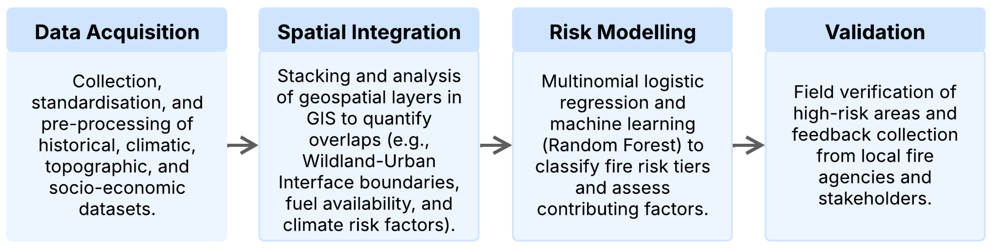
2.4. Predictive Modeling and Risk Analysis with Machine Learning

This study employs machine learning models to enhance predictive accuracy and spatial delineation of wildfire risks. Algorithms such as Multinomial Logistic Regression (MLR), Random Forest (RF), and XGBoost were applied to large datasets encompassing climatic, vegetation, land-use, and socio-economic variables, identifying the most influential factors driving wildfire occurrences. These models generated risk maps that highlight vulnerable regions based on historical wildfire data and projected scenarios. Supervised learning techniques, including clustering, were utilized to detect emerging patterns in wildfire frequency and severity, improving upon traditional risk assessment methods by offering high-resolution spatial classifications. The selection of these models was based on their suitability for wildfire risk assessment, as demonstrated in previous studies. MLR was chosen for its ability to model categorical dependent variables and provide interpretable relationships between wildfire susceptibility and predictor variables. RF was selected for its capacity to handle complex, non-linear relationships and its robustness against overfitting, making it particularly useful for integrating diverse environmental and socio-economic datasets. XGBoost was incorporated as an additional model due to its efficiency in handling large datasets and its capacity for improved predictive accuracy through gradient-boosting techniques. This analytical framework enhances both immediate response strategies and long-term wildfire mitigation planning [26,27,28,29,30].
To classify risk levels, Multinomial Logistic Regression (MLR) (Equation (1)) was employed, estimating the probability of an area belonging to a specific risk category based on key predictive variables, including humidity, temperature, precipitation, wind speed, and terrain attributes. The logistic regression function is defined as follows:
P y = 1 | X = 1 + e β 0 + β 1 X 1 + β 2 X 2 + + β n X n 1
where P(y = 1|X) represents the probability of an observation belonging to a wildfire risk category, given the predictor variables X n , and β n are the regression coefficients estimated during model training. While MLR allows for a clear interpretation of individual variable contributions, its performance is limited in capturing non-linear relationships between wildfire determinants.
To improve predictive accuracy and account for complex variable interactions, ensemble models were introduced. Random Forest (RF) was employed due to its robustness in reducing overfitting by aggregating multiple decision trees trained on random samples. This approach was particularly effective in modeling the interaction between topographic features and proximity to ignition sources (roads, electrical infrastructure). In contrast, XGBoost, an optimized gradient boosting algorithm, improved predictive power by iteratively correcting model errors and applying regularization techniques to enhance generalization.
A multi-layered modeling approach integrating climatic, spatial, and socio-economic data was implemented for comprehensive wildfire risk assessment. GIS-enabled overlays facilitated the spatial correlation of vegetation indices (NDVI), land-use classifications, and demographic factors with wildfire occurrences, enhancing risk map generation. Machine learning models identified significant non-linear interactions between climatic, anthropogenic, and environmental variables, refining the classification of wildfire-prone regions.
The study area was segmented into 1 km2 grid cells, enabling microscale analysis of wildfire risk. Each cell was classified into one of five risk levels—‘Very Low’, ‘Low’, ‘Moderate’, ‘High’, and ‘Very High’—based on predictive variables, including humidity, temperature, wind speed, altitude, proximity to roads, land use, and cadastral land value. This spatial segmentation ensures a high level of granularity and precision in the identification of critical wildfire zones, improving the effectiveness of risk mitigation strategies and resource allocation for fire prevention in Ambato.

2.5. Validation and Analysis

Machine learning models and simulation outputs are evaluated using historical wildfire data, comparing predicted fire occurrences with recorded events to assess model performance [26,27,28]. Machine learning algorithms use metrics such as accuracy, precision, and recall to evaluate their predictive capabilities, while sensitivity analyses assess the robustness of simulation models under different conditions.
Outputs from GIS, machine learning, and simulation models are integrated to generate comprehensive risk maps and scenario analyses. The results highlight the spatial distribution of risks, identifying regions where climatic, environmental, and socio-economic factors intersect, leading to increased vulnerabilities. The study also evaluates the effectiveness of proposed mitigation strategies, such as controlled burns and urban planning policies, through simulation models to predict their impact across various scenarios.

3. Results

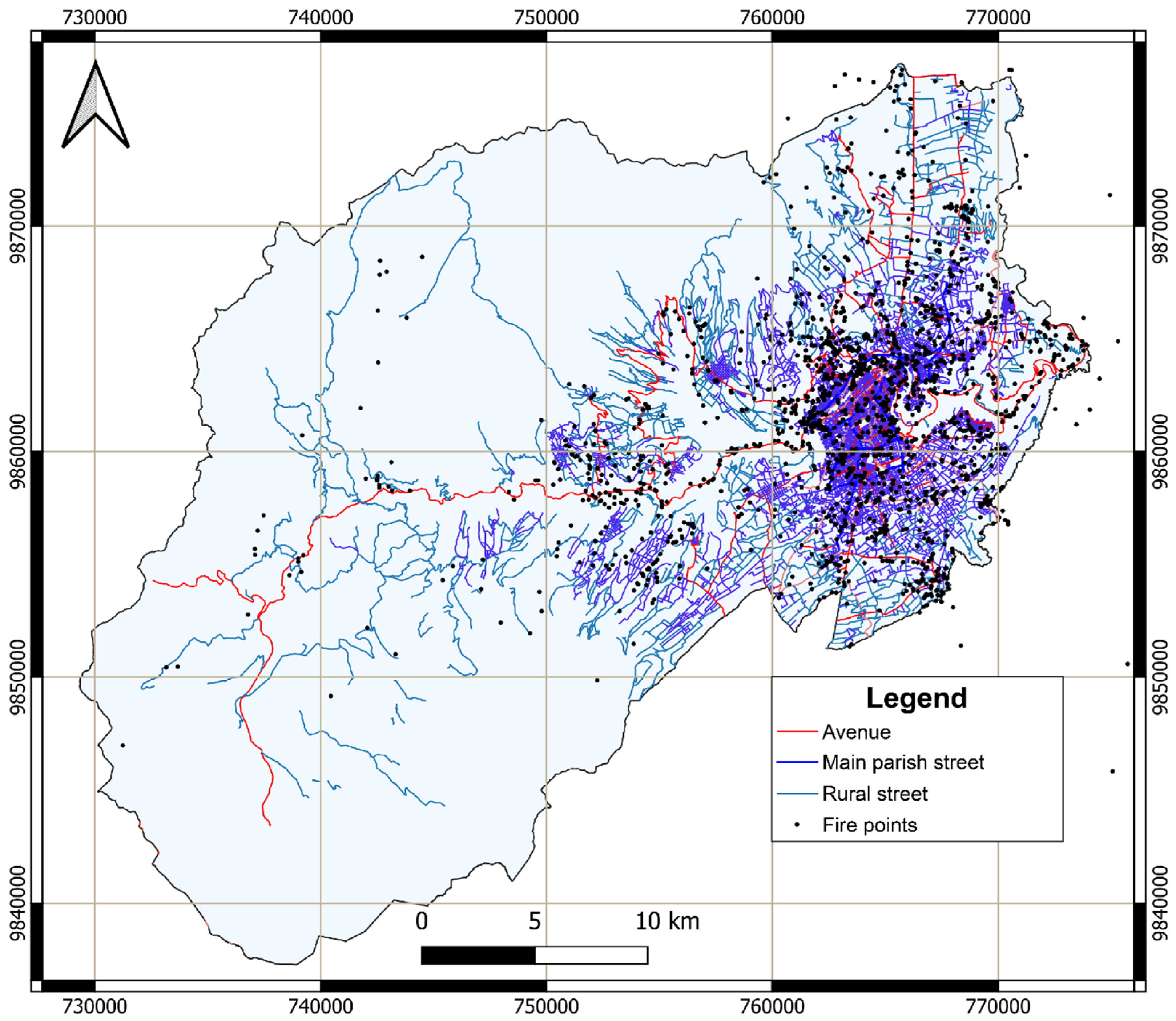
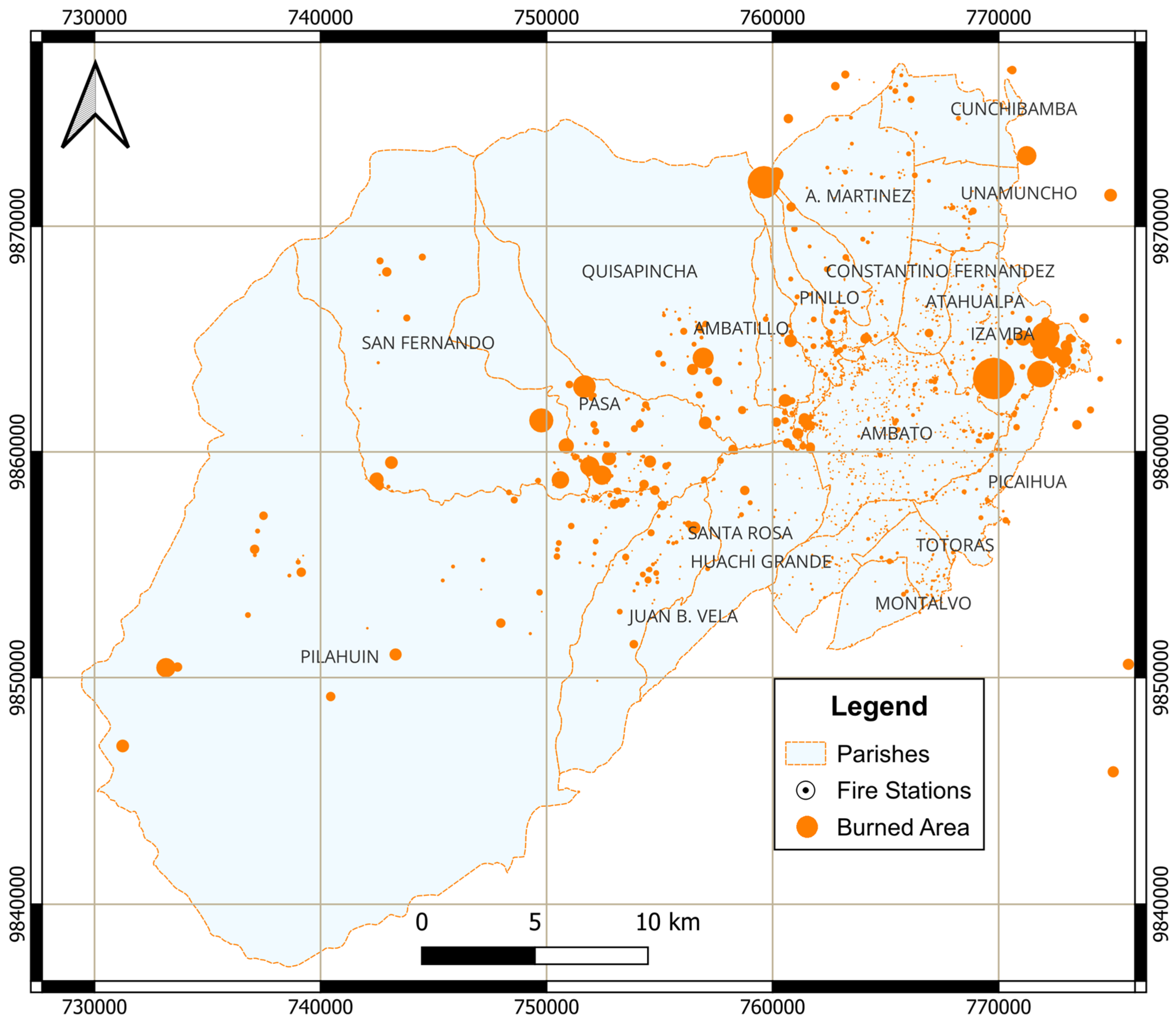
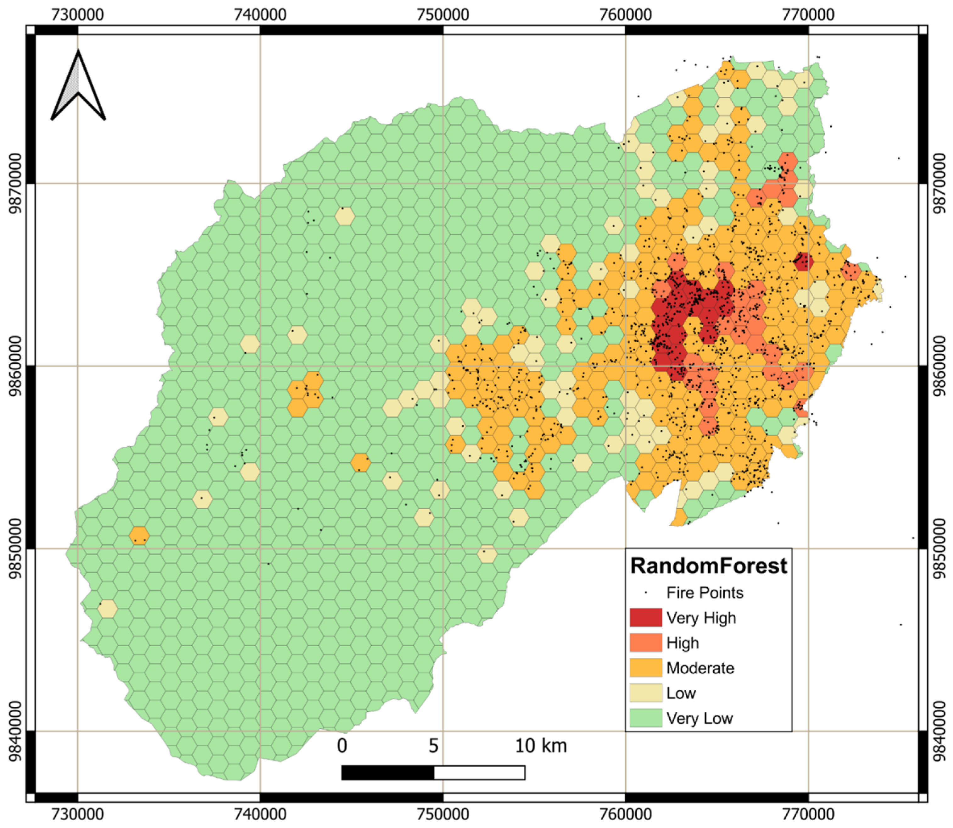
3.1. Identification of High-Risk Areas

The thematic risk maps generated from the integration of climatic and socio-economic data identified significant high-risk zones within the urban–wildland interface of Ambato. These zones, characterized by dense vegetation cover, proximity to human settlements, and climatic conditions conducive to ignition, were predominantly located in areas with high population density and active land-use changes. By segmenting the study area into 1 km2 grid cells, microscale variations in risk levels were visualized. The analysis classified these cells into five categories: ‘Very Low’, ‘Low’, ‘Moderate’, ‘High’, and ‘Very High’. Results revealed that areas with ‘Very High’ risk were concentrated near agropastoral lands and unregulated urban expansions, often correlating with zones of low precipitation and high temperature anomalies. These insights provide a detailed spatial understanding of wildfire susceptibility, enabling targeted mitigation efforts in particularly vulnerable areas.
By superimposing socio-economic data onto these risk maps, a deeper understanding of how human activities increase wildfire hazards was achieved. This geospatial analysis not only identifies high-risk locations but also establishes direct correlations between environmental conditions and anthropogenic factors. Figure 3 displays the spatial distribution of burned areas in Ambato, based on data provided by the Ambato Fire Department [19].
Table 2 presents the total burned area (in hectares) per parish in Ambato between 2017 and 2023, highlighting significant annual variability in wildfire activity. Historical wildfire data from the Fire Department of Ambato indicates an average of 120 wildfire incidents annually, with significant peaks observed in 2020, where 1500 hectares were burned, and in 2023, with 791 hectares burned. The Izamba parish experienced the highest impact, with 884.9 hectares burned, largely attributed to a significant outbreak in 2020, which accounted for 609 hectares. The parishes of Pasa and San Fernando experienced 598.2 hectares of land burned, with peak fire occurrences recorded in 2023 (156.5 ha) and 2020 (150.8 ha), respectively. Extreme fire seasons occurred alongside extended drought conditions and temperature anomalies, which intensified fuel desiccation and increased ignition risks.
In addition, Figure 4a illustrates the annual trend in the burned areas, confirming that the dry season from July to November corresponds to the highest fire occurrences, particularly in the Wildland–Urban Interface (WUI). November was identified as the most significant month, with 1008 hectares burned and 187 recorded wildfire events, aligning with peak solar radiation levels. An additional variable was incorporated into the analysis to evaluate potential correlations between human activities and wildfire occurrence: the number of households engaged in open waste burning. The spatial overlap indicates a potential connection between informal waste disposal and the ignition of wildfires, especially during years characterized by extended drought conditions, such as 2020. The 2020 fire season, which diverged from global wildfire trends during the COVID-19 lockdown, can be attributed to decreased land management activities, heightened fuel accumulation, and changes in human behavior resulting from pandemic-related socio-economic disruptions.
Additional thematic maps were generated to illustrate the increased wildfire risk in rapidly urbanizing regions. The expansion of residential developments into natural areas disrupts ecological balance, increasing the availability of combustible materials such as organic waste and dry vegetation [9,49]. These maps serve as a critical tool for policymakers, allowing them to prioritize mitigation strategies in the most vulnerable areas and allocate resources effectively. Wind speed distribution was analyzed to identify areas where fire spread could be accelerated. Strong winds significantly influence wildfire behavior by intensifying flame propagation and increasing ember transport over long distances. Figure 5 highlights wind speed variations across the city, emphasizing areas particularly susceptible to rapid fire expansion.
Prolonged droughts significantly impact fuel availability and moisture retention, increasing wildfire risk in Ambato. Climatic records indicate that dry periods are becoming more frequent and extended, reducing vegetation moisture content and intensifying flammability, particularly in grasslands and shrublands [16,21]. Figure 6 illustrates vegetation cover and its relationship to high-risk zones, highlighting areas with reduced moisture and increased fuel accumulation. Additionally, Figure 7 presents the altitudinal distribution across the study area, demonstrating how elevation influences fire susceptibility by shaping local climatic conditions and fuel dynamics.

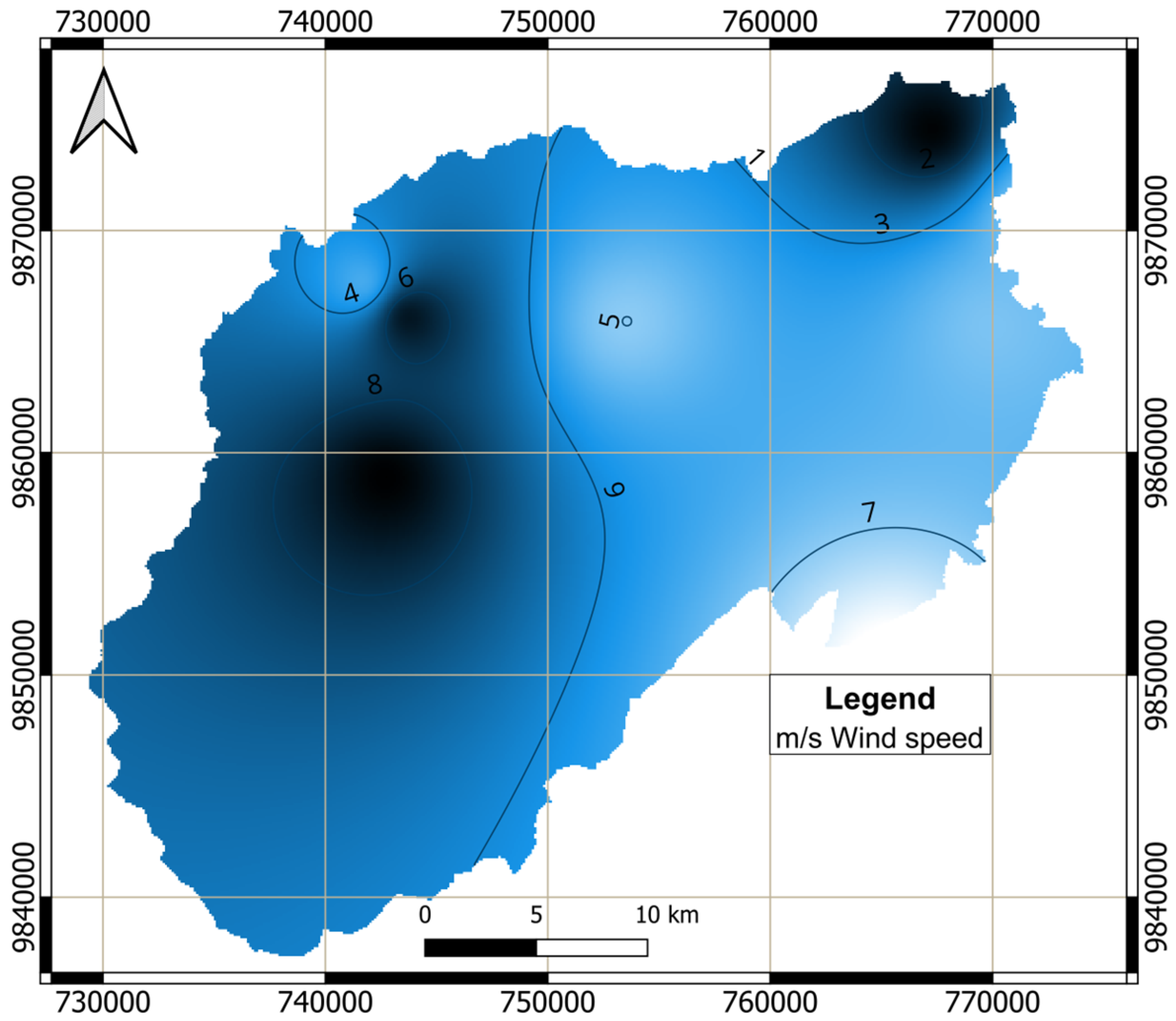
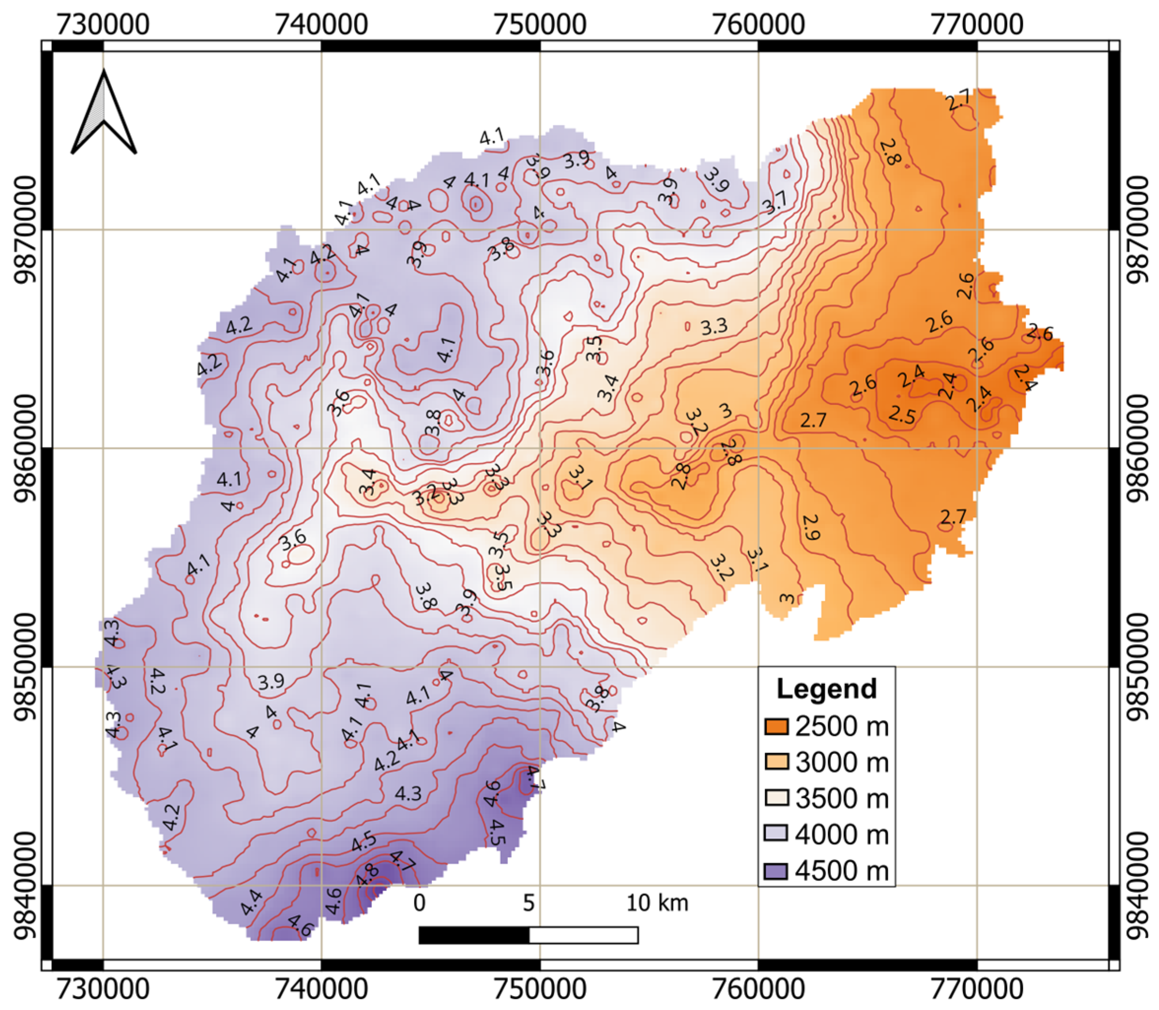
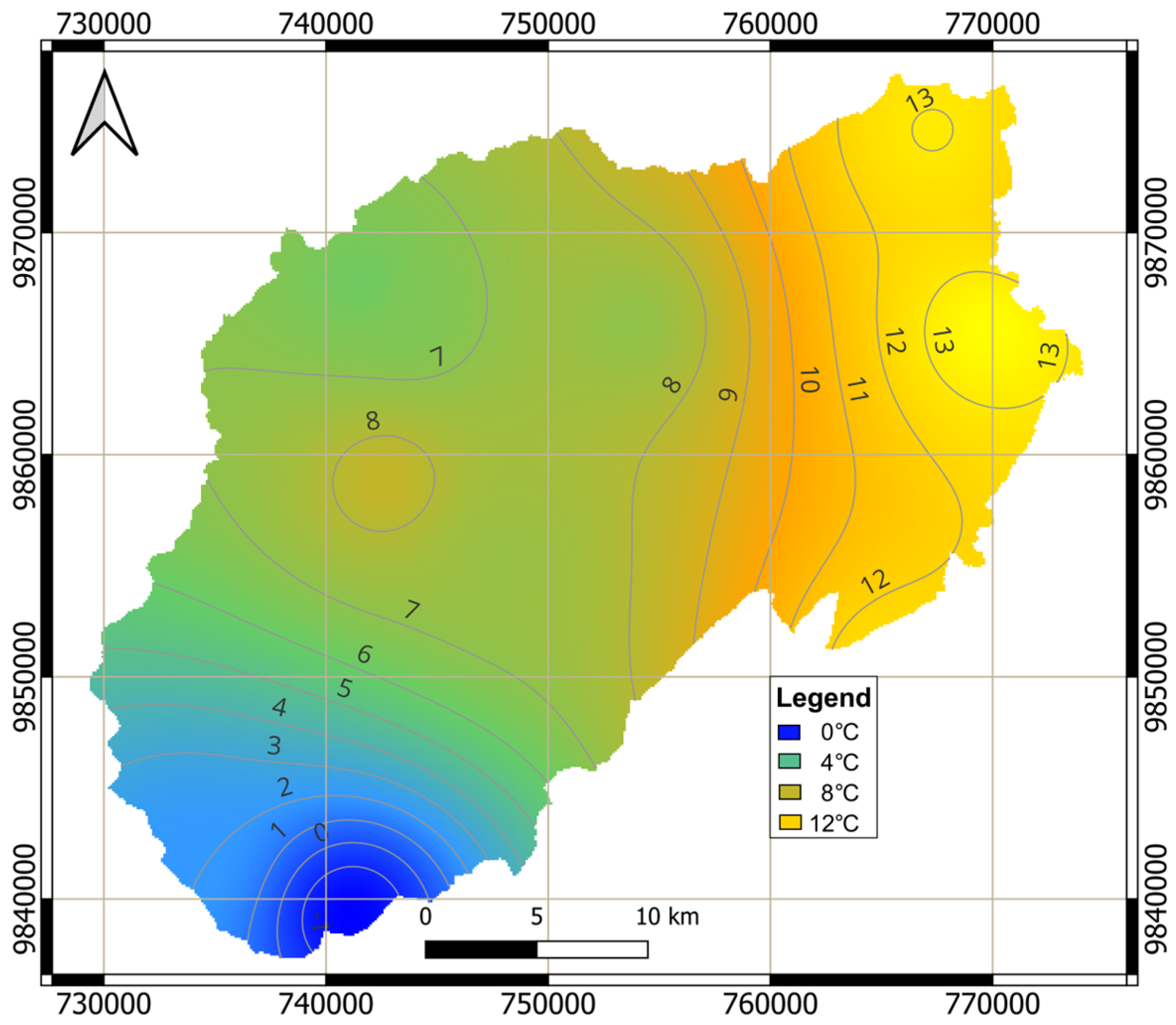
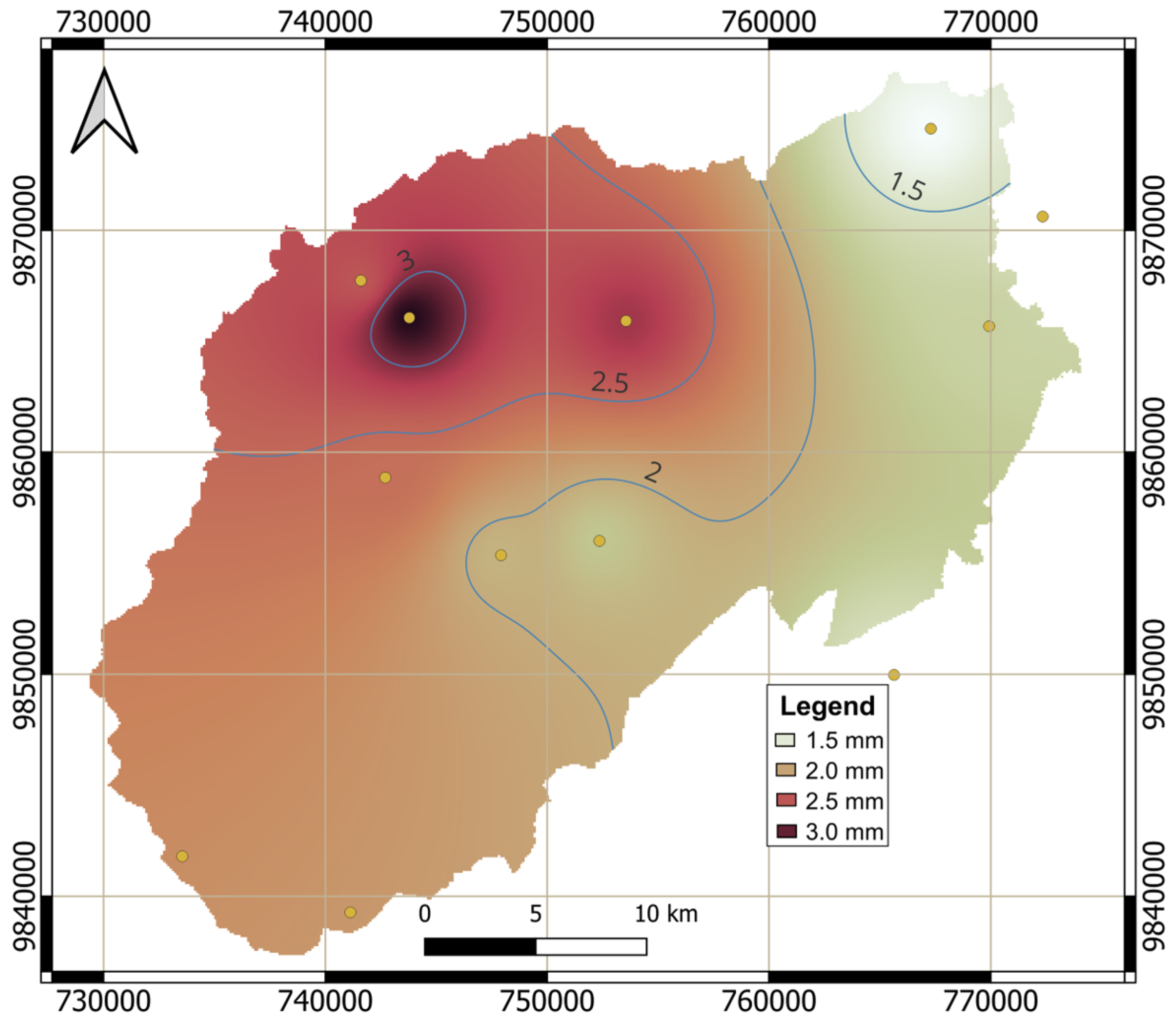
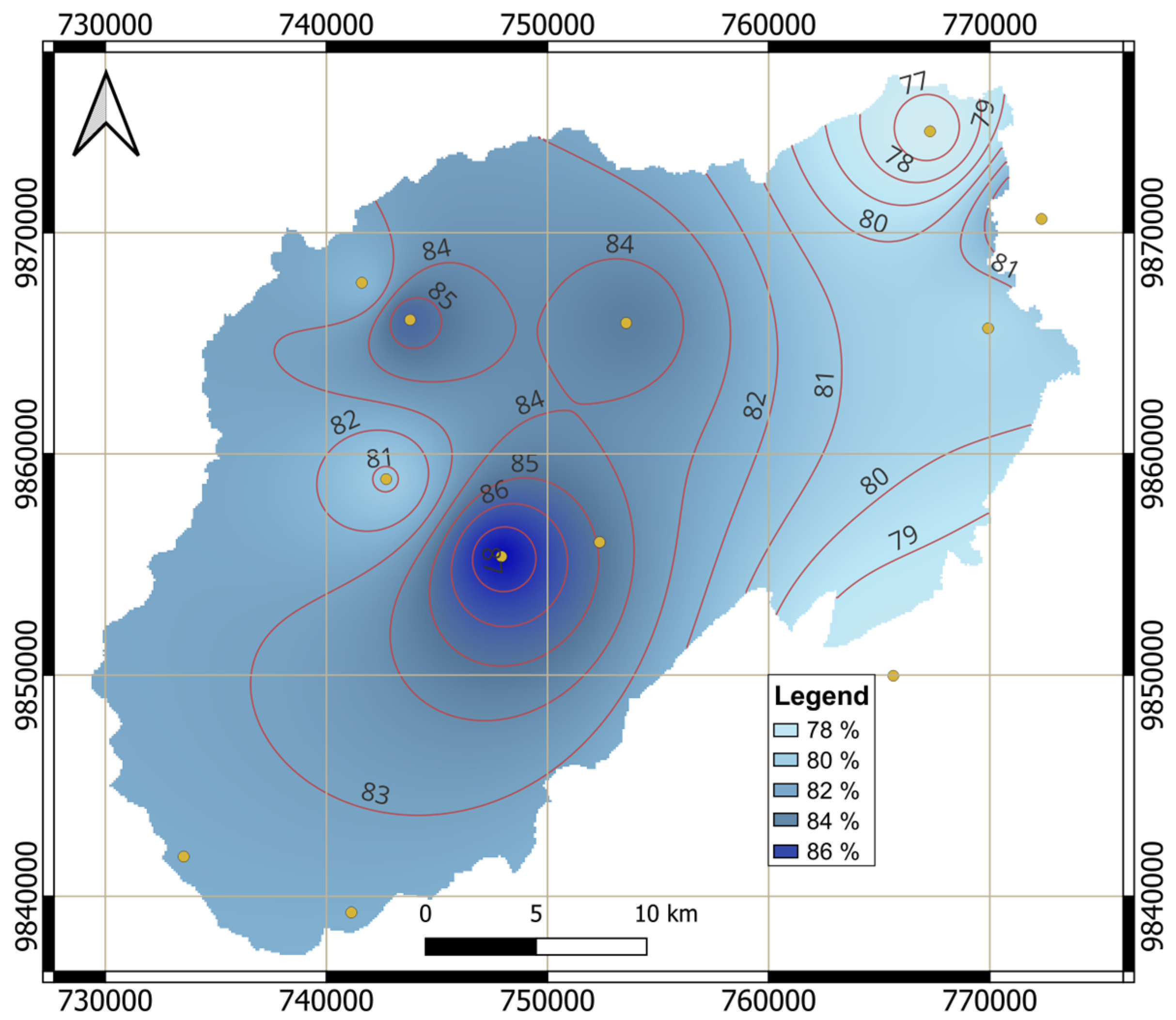
3.2. Climatic Factors
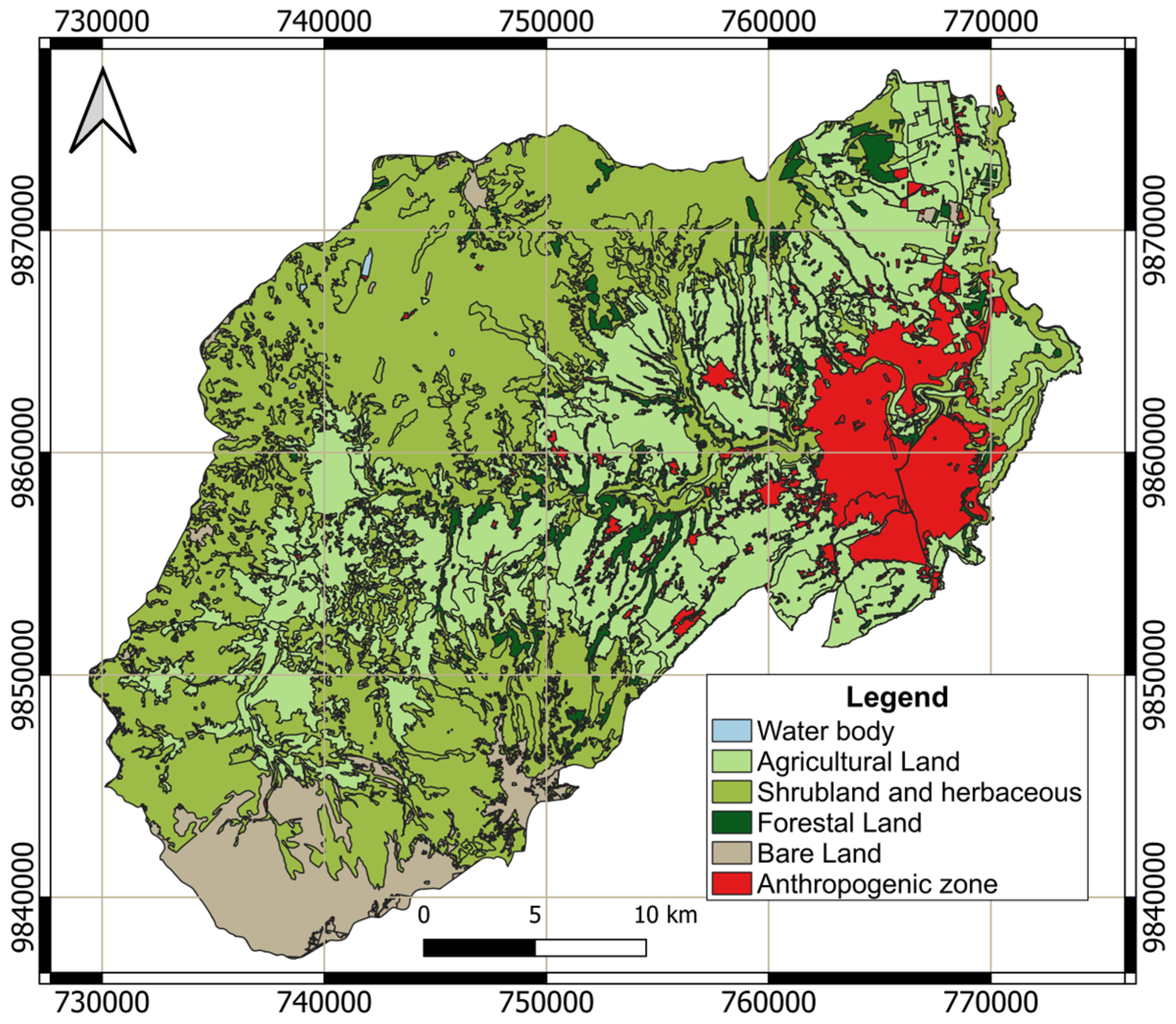
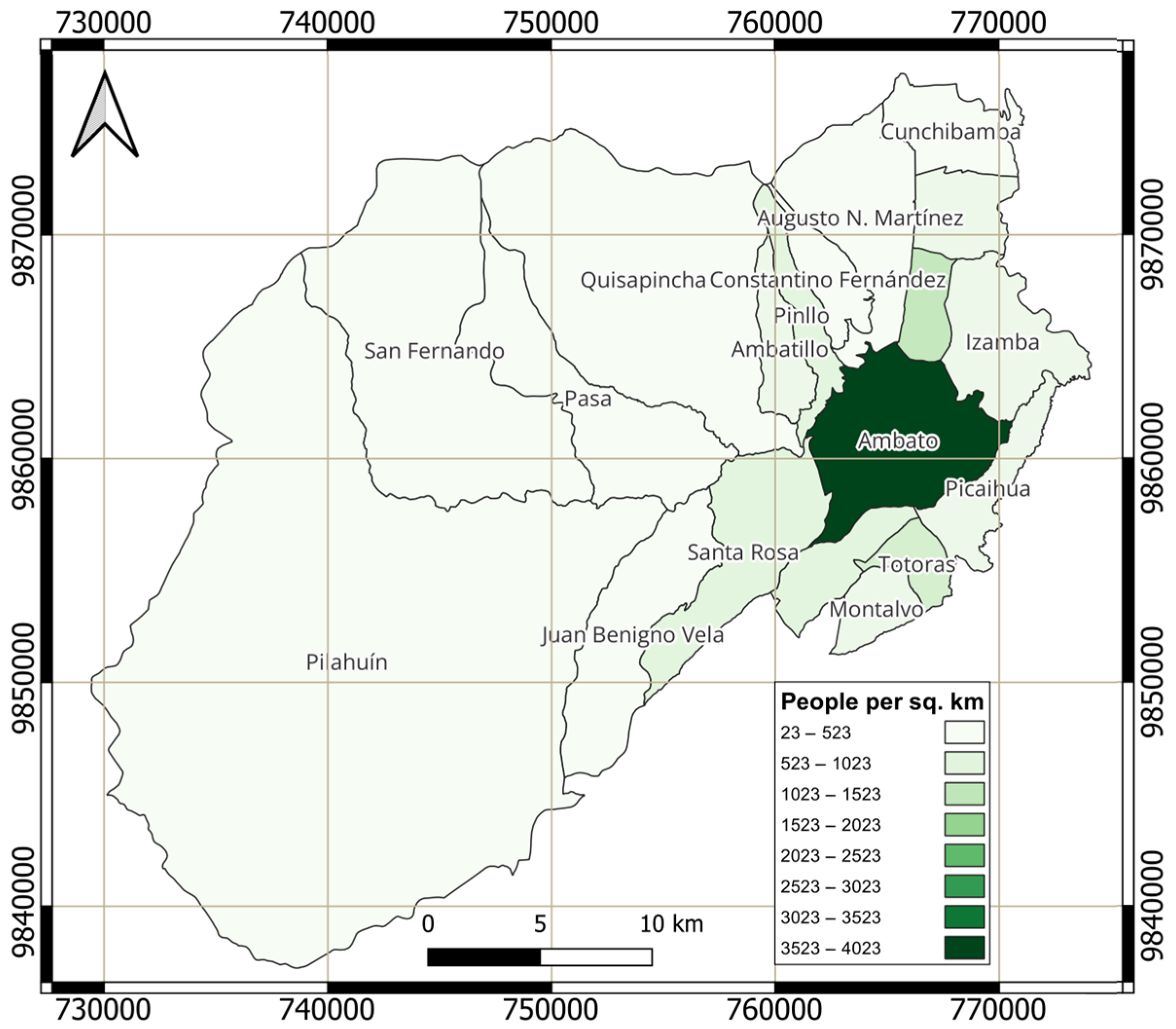
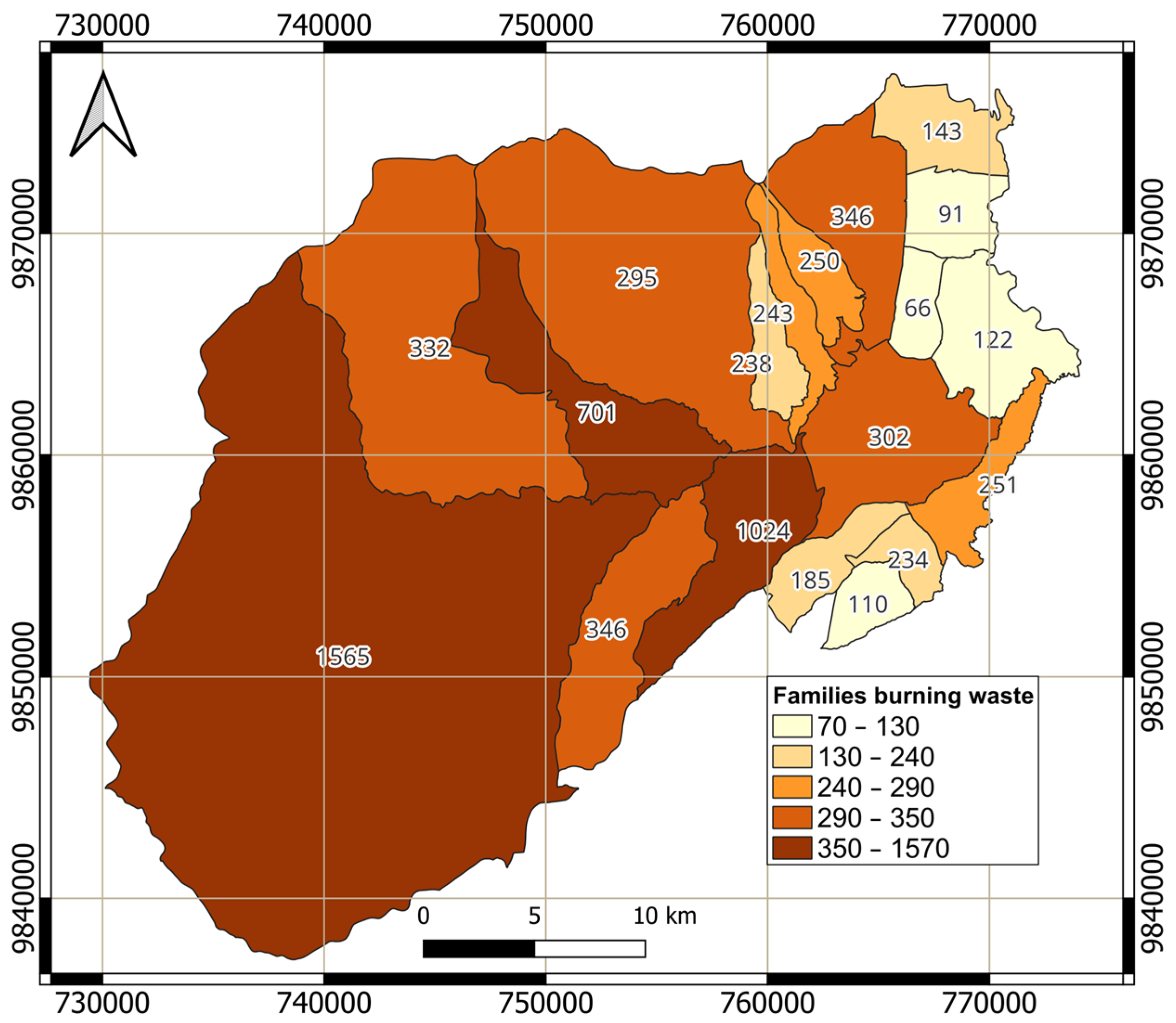
Climatic variability plays a pivotal role in shaping wildfire dynamics in Ambato, with temperature anomalies emerging as a key driver of vegetation desiccation and increased flammability. Analysis of historical temperature records reveals a persistent upward trend, with extreme heat events accelerating moisture loss in grasslands and shrublands. These conditions create highly combustible environments, particularly in regions experiencing prolonged dry spells. Figure 8 illustrates the spatial distribution of average temperatures across the canton, highlighting the correlation between heat-intensified fuel desiccation and wildfire-prone areas. Additionally, precipitation deficits exacerbate fire susceptibility by reducing soil moisture and delaying vegetation recovery after fire events. Figure 9 presents the temporal distribution of rainfall patterns, demonstrating how irregular precipitation cycles contribute to fuel accumulation and prolonged drought stress, ultimately elevating wildfire risks.
Relative humidity further influences wildfire behavior by affecting the rate of fuel ignition and combustion. Areas exhibiting consistently low humidity levels, as depicted in Figure 10, correspond with zones of heightened vegetation flammability, particularly within the Wildland–Urban Interface (WUI), where human activities increase ignition potential. Steep terrains with slopes exceeding 25° present additional challenges, as seasonal winds accelerate fire spread by preheating upslope fuels. These winds, combined with drought-driven vegetation stress, create volatile conditions that complicate fire suppression efforts. The integration of climatic and spatial data enables the identification of priority intervention zones where targeted mitigation strategies—such as controlled clearing of flammable vegetation and the restoration of drought-resistant native species—can enhance ecological resilience and inform broader wildfire management frameworks, particularly for climate-sensitive mountainous regions like the Andes [18,22,50,51].

3.3. Human Factors

Wildfire frequency in Ambato exhibits strong correlations with population density and high-risk human activities. The Wildland–Urban Interface (WUI), particularly informal settlements, experiences elevated fire incidence due to waste burning, agricultural land-clearing fires, and the unregulated use of fire for land management. Spatial analysis reveals that ignition hotspots are concentrated in densely populated areas, where flammable materials such as agricultural debris and household waste accumulate near residential zones. Figure 11 illustrates the population density distribution, highlighting the spatial overlaps between high-density settlements and frequent ignition points.
These communities, often lacking adequate fire suppression infrastructure, are disproportionately affected during wildfire events. Figure 11 also helps us emphasize the critical intersections between land-use practices, population density, and fire ignition sources, underscoring the urgent need for stricter regulations on open burning in the WUI. Additionally, targeted interventions such as community-led fire prevention programs, stricter land-use policies, and infrastructure improvements in informal settlements are essential to reducing human-induced wildfire risks [4,11,13,14]. Understanding these socio-environmental dynamics is crucial for developing data-driven prevention strategies, strengthening fire safety regulations, and mitigating the impact of human activities on wildfire occurrence.

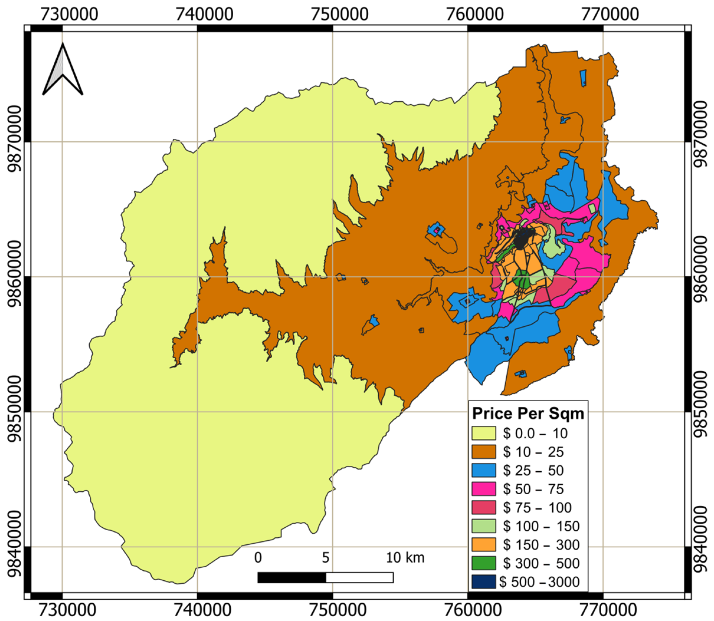
3.4. Socio-Economic Vulnerabilities and Fire Risk

The integration of socio-economic data with environmental and spatial datasets highlights the compounded vulnerabilities affecting Ambato’s population. Figure 12 presents the cadastral land-value distribution, illustrating economic disparities that directly influence resource allocation for wildfire prevention and mitigation. Marginalized communities in low-value cadastral zones often receive fewer resources, limiting their capacity to implement fire-resistant measures and preparedness initiatives. Additionally, Figure 13 depicts the prevalence of household waste burning, a major ignition source in high-risk areas. The widespread use of open burning for waste disposal, particularly in lower-income neighborhoods, exacerbates fire hazards in the Wildland–Urban Interface (WUI) [11,12,15,25].
Public awareness also emerged as a significant challenge. Surveys reveal that residents in fire-prone areas often lack knowledge of fire safety protocols, with existing educational initiatives failing to address gaps among marginalized groups. Socio-economic inequalities further amplify these issues, as low-income households are less likely to adopt fire-safe practices such as maintaining defensible spaces or using non-flammable building materials. These findings emphasize the necessity for targeted interventions that ensure equitable resource allocation, prioritize high-risk communities in firefighting investments, and expand multilingual outreach programs to improve fire safety awareness [49,52,53]. Moreover, strengthening land-use policies to limit urban encroachment into fire-prone ecosystems is essential in mitigating fire risks, particularly in the WUI.

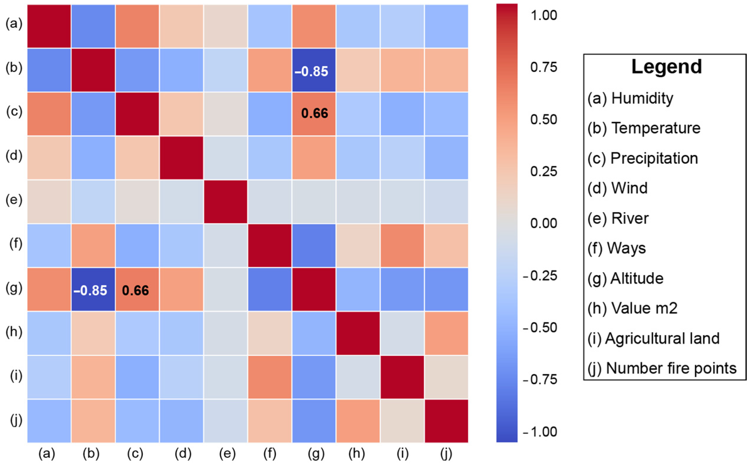
3.5. Data Correlation Analysis

The correlation analysis was conducted to examine the relationships between wildfire occurrences and key environmental and socio-economic variables, offering insights into the factors influencing fire dynamics. Pearson and Spearman correlation coefficients were employed to assess both linear dependencies and monotonic associations between variables. Figure 14 presents a Pearson correlation heatmap, visually illustrating the strength and direction of these relationships. In this representation, values approaching 1 indicate a strong positive correlation, while values near −1 suggest a strong inverse relationship.
The analysis reveals that land value per square meter (0.51) correlates positively with wildfire frequency, suggesting that areas with higher land costs, likely due to greater urbanization and human activity, experience more fire incidents. Mean altitude (−0.52) exhibits a negative correlation with wildfire occurrence, indicating that fires are less frequent at higher elevations, possibly due to differences in vegetation type and climatic conditions. Additional significant correlations include mean temperature (0.40), proximity to roads (0.33), and mean humidity (−0.33), underscoring their impact on wildfire risk. These findings highlight the complex interplay between socio-economic and environmental factors in shaping wildfire behavior in Ambato.

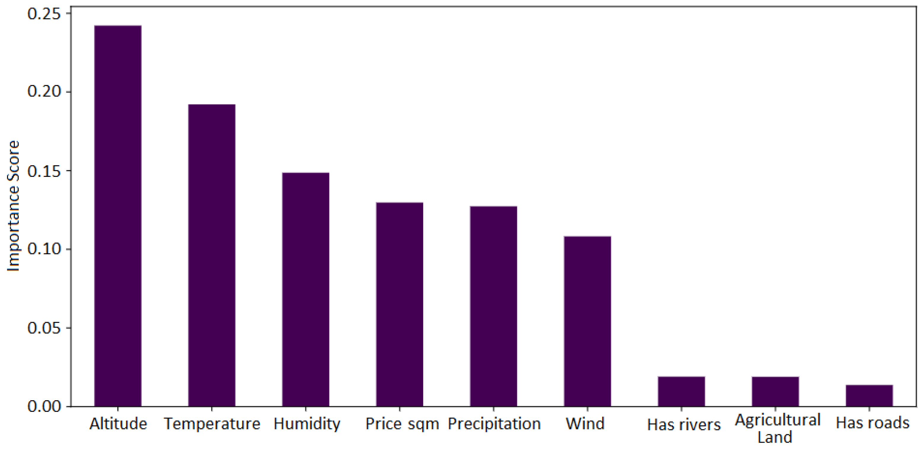
3.6. Model Predictions

3.6.1. Multinomial Logistic Regression (MLR)

The predictive modeling using Multinomial Logistic Regression (MLR) provided a probabilistic classification of wildfire risk across the study area. The model achieved an accuracy of 76.04%, demonstrating its reliability in predicting “Moderate”, “High”, and “Very High” risk areas. The regression coefficients revealed significant predictors, including temperature anomalies, which were positively correlated with higher risk levels, and altitude, which was negatively associated with “Very High” risk areas. Simulated scenarios under variable climatic conditions highlighted that increased wind speeds and reduced precipitation significantly shifted risk distribution toward higher categories. These predictive insights enable the identification of priority areas for immediate intervention and long-term planning [7,27,30,31,44,47]. According to the model, fire spreads rapidly through grasslands and shrublands under severe drought and strong wind conditions, making containment extremely difficult. The surrounding geography of Ambato, with steep slopes, exacerbates fire dynamics by facilitating rapid uphill spread and increasing the fire’s area of influence. Conversely, scenarios with moderate wind speeds and higher vegetation moisture levels show reduced fire spread, emphasizing the importance of proactive fuel management techniques, such as controlled burns, to mitigate risks.
The MLR model allowed for a detailed analysis of each variable’s influence on wildfire risk classification. Figure 15 depicts the regression coefficients, demonstrating how different environmental and socio-economic factors contribute to the probability of wildfire occurrence. Notably, the “Very High” risk category exhibits a direct relationship with altitude, reinforcing the role of topography in wildfire susceptibility. Following the application of the Multinomial Logistic Regression (MLR) algorithm, a wildfire risk map was generated, as shown in Figure 16. The results indicate that areas with a “High” probability of wildfire are primarily located in the urban zone, characterized by lower altitude, situated on the right side of the map. In contrast, zones classified as “Very High” risk are concentrated along the main inter-parish connection road between Pasa and San Fernando, suggesting higher exposure to wildfire hazards in this strategic area. Additionally, it is important to highlight that the “Very High” risk areas identified in the MLR-based wildfire risk map are predominantly influenced by land-use type, particularly agricultural lands, and proximity to water bodies. Unlike other models that prioritize historical wildfire occurrences, MLR assigns risk based on the statistical relationship between predictor variables and wildfire likelihood. As a result, areas with extensive agricultural activity and adjacency to rivers were classified as “Very High” risk, despite not necessarily coinciding with past wildfire hotspots. This underscores the influence of land-use patterns and hydrological proximity in shaping wildfire susceptibility, reinforcing the necessity of integrating these factors into risk assessment frameworks.

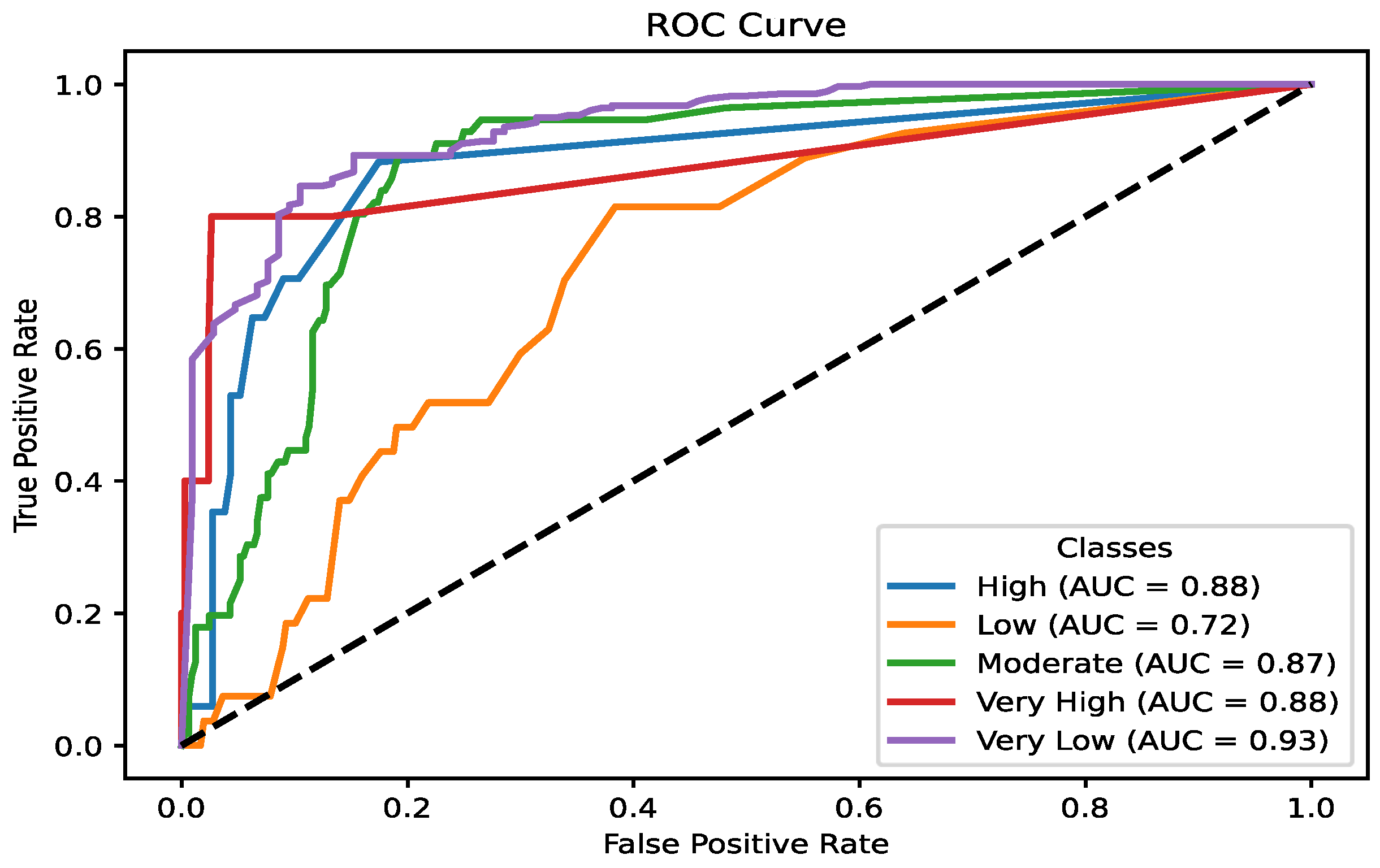
3.6.2. Random Forest
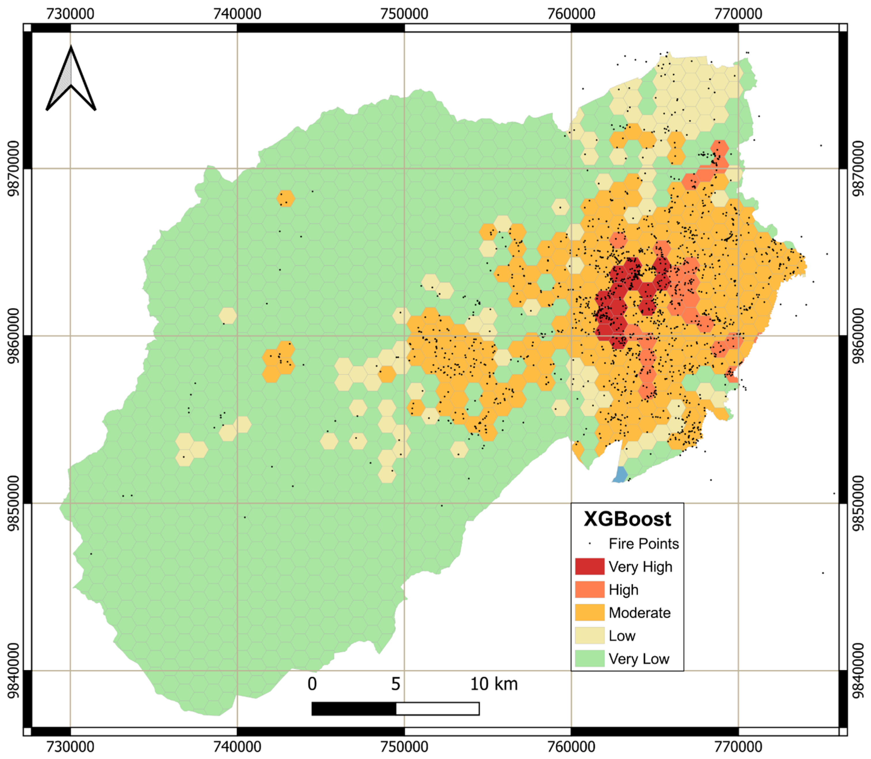
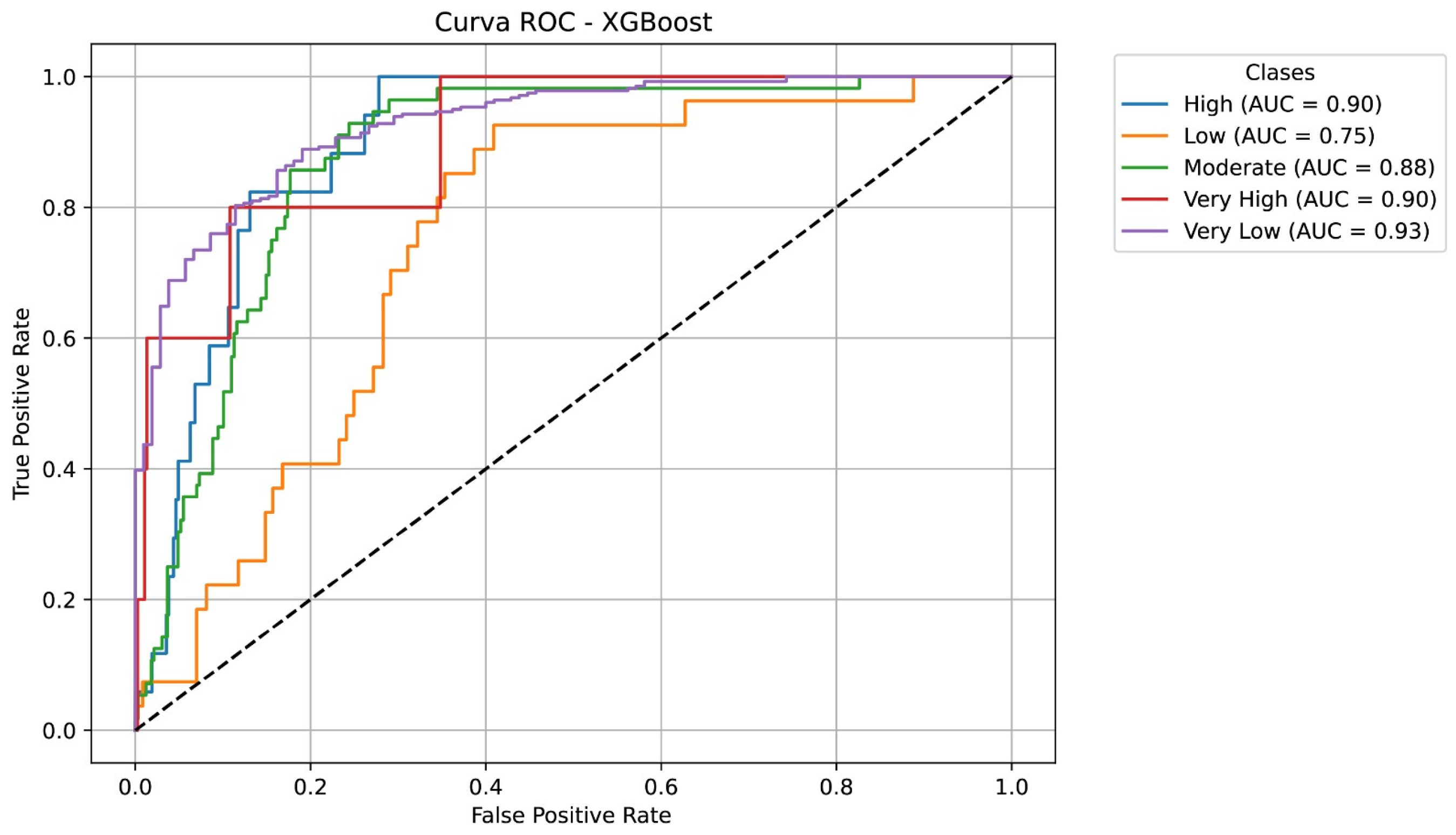
The Random Forest model was applied to assess the significance of various environmental and socio-economic variables in wildfire prediction. As illustrated in Figure 17, mean altitude and mean temperature emerged as the most influential factors, reinforcing the role of topography and climatic conditions in fire risk dynamics. The model achieved an accuracy of 0.776, enabling the generation of a detailed wildfire risk map for Ambato. The spatial distribution of wildfire susceptibility, shown in Figure 18, highlights that “Very Low” risk areas are predominantly located in high-altitude páramo ecosystems with sparse vegetation and minimal human activity. Meanwhile, “Low” to “Moderate” risk zones extend toward the urban periphery, correlating with transitional land-use areas. The highest risk levels, classified as “Very High”, are concentrated in the Wildland–Urban Interface (WUI), where urban expansion, increased population density, and rising temperatures significantly amplify wildfire hazards.
The Receiver Operating Characteristic (ROC) curve analysis, presented in Figure 19, was conducted to evaluate the classification performance of the Random Forest model across different wildfire risk levels (Very Low, Low, Moderate, High, and Very High). The Area Under the Curve (AUC) values indicate strong classification capability, with all categories achieving an AUC score above 0.7. The best-performing classes include Very Low (0.93), High (0.88), and Very High (0.88), demonstrating the model’s accuracy in distinguishing these risk levels. Conversely, the “Low” risk class had the lowest AUC value (0.72), suggesting a degree of misclassification and potential confusion with adjacent risk categories. Refining the model—through improved feature selection, resampling techniques, or hyperparameter tuning—could enhance the distinction between risk classes and further improve overall predictive performance [28,29,31,32].
The model results indicate that altitude plays a crucial role in wildfire risk assessment, as it directly influences fuel availability and fire propagation dynamics. As altitude increases, vegetation density and fuel accumulation tend to decrease, limiting fire spread potential despite the presence of ignition sources. This explains why the highest-risk areas are concentrated in lower-altitude regions, particularly in transitional zones between urban expansion and fire-prone ecosystems. Additionally, while anthropogenic activities such as agricultural burning and waste disposal significantly contribute to fire ignition, they do not necessarily determine fire propagation patterns. In this context, the model prioritizes climatic and topographic factors, such as temperature and altitude, as dominant drivers of wildfire risk. These findings highlight the need for integrated fire management strategies that address both ignition prevention and fire containment measures in vulnerable areas.

3.6.3. XGBoost

The XGBoost model achieved an accuracy of 0.765, demonstrating strong capabilities in wildfire risk classification. The generated risk distribution closely aligns with the results obtained from the Random Forest model. “Very Low” risk areas dominate most of Ambato’s landscape, particularly in high-altitude regions with sparse vegetation and minimal human influence. Conversely, “Very High” risk zones are concentrated near the city center, where urban expansion and proximity to combustible materials significantly increase wildfire vulnerability. Figure 20 presents the wildfire risk map generated using the XGBoost model, highlighting critical areas requiring targeted mitigation strategies.
The ROC curve analysis further evaluates the performance of the XGBoost model across different wildfire risk categories. The results indicate that “Very Low”, “High”, and “Very High” risk classes exhibit strong discrimination capabilities, with AUC values above 0.85. The “Moderate” category achieves an AUC of 0.88, demonstrating acceptable predictive performance. However, the “Low” category records the lowest precision (AUC = 0.75), suggesting greater difficulty in distinguishing low-risk wildfire occurrences from other classes. Figure 21 illustrates the ROC curve analysis, highlighting areas for potential model refinement. To improve classification accuracy, adjustments in feature selection and classification thresholds are recommended, particularly for enhancing the differentiation of low-risk wildfire zones and reducing misclassification errors [27,28,30,31,32].

4. Discussion

The results illustrate the complex interplay between climatic, ecological, and human factors that drive wildfire risk in Ambato. It was demonstrated that climatic variables, such as temperature anomalies, prolonged droughts, and wind dynamics, exacerbate fuel desiccation and ignition susceptibility, while ecological factors, such as vegetation cover and altitude, further influence fire behavior. Human activities, including waste burning and urban expansion, amplify these risks by introducing ignition sources into high-risk areas. The segmentation of the city into 1 km2 polygons provides granular information, allowing for the identification of microscale risk patterns that align with other similar studies [3,6,54].
The practical implications of this study highlight the need for targeted interventions at both local and regional levels. Moreover, thematic maps provide practical information for urban planning, particularly in regulating land use to prevent urban expansion into fire-prone zones. The integration of socio-economic variables into risk assessments further underscores the importance of community-based strategies, such as public awareness campaigns and training programs, to mitigate anthropogenic ignition sources. These findings align with international best practices and demonstrate the value of combining data-driven approaches with local knowledge to effectively address wildfire risks [3,35,55].
The findings from Ambato contribute to broader discussions on wildfire management in climate-vulnerable regions. The study employs a multi-layered methodology that integrates ecological, socio-economic, and climatic assessments, offering a reproducible framework adaptable to other regions facing similar hazards. This research highlights the need for proactive, data-driven interventions by identifying the interconnected vulnerabilities of high-altitude ecosystems and urban–wildland interfaces. The findings indicate the benefits of integrating local strategies, such as community-based fire management and reforestation efforts, with international best practices, including controlled burns and predictive modeling [3,56,57].
The integration of thematic maps, predictive models, and socio-economic data provides a solid framework for policy development. For example, land-use regulations based on spatial risk assessments can limit urban expansion into high-risk areas, reducing the exposure of vulnerable populations. Community education and engagement strategies must complement these policies, fostering a culture of fire prevention and preparedness. The segmentation approach used in this study offers a scalable methodology that can be adapted to other Andean regions, supporting broader initiatives in wildfire management and climate resilience. The use of machine learning in this context further enhances the predictive capacity of risk models, providing policymakers with a dynamic tool to prioritize interventions and optimize resource allocation [3,18,22,56,57].
Three classification models were used in this research: Multinomial Logistic Regression (MLR), Random Forest, and XGBoost. MLR relies on the linear relationship between variables to determine the probability of belonging to a specific category, leveraging global patterns in the data. Random Forest and XGBoost employ decision trees that iteratively divide the dataset based on the most relevant features, optimizing predictions by combining multiple trees and reducing overfitting. These approaches have been widely used in previous studies due to their ability to model complex relationships and enhance classification accuracy [25,26,27,28,29,30,31,32].
The maps generated by these models show significant differences in the spatial distribution of wildfire risk. The MLR model indicates a higher prevalence of “High” risk areas on the right side of the map, with “Very Low” risk areas concentrated on the left. It identifies Ambatillo, Pasa, and San Fernando parishes as the highest-risk zones. Conversely, Random Forest and XGBoost classify “Very High” risk areas primarily in urban zones, where wildfires occur frequently but have lower spread potential. These models assign “Very Low” risk to most of the territory, reflecting a wider distribution of low-risk zones.
Authorities responsible for territorial management must select the most suitable model based on their specific needs. The MLR-based map is particularly useful for analyzing fire frequency in specific areas, as it provides a direct estimate of fire probability per polygon. Meanwhile, the Random Forest and XGBoost models may be more appropriate for strategic decision-making, offering a more detailed and conservative risk assessment that is crucial for policy formulation. Since all three models exhibit similar accuracy scores—76.04% (MLR), 77.6% (Random Forest), and 76.5% (XGBoost)—the choice of model should align with the specific objectives of wildfire risk assessment and mitigation strategies [52,54,58,59,60,61].

4.1. Mitigation Strategies and Policy Recommendations

Investments in firefighting resources, including modern fire trucks, protective equipment, and strategically placed water reservoirs, are essential for improving emergency response capacity in rural and high-risk areas. Enhancing fire station networks in underserved regions would significantly reduce response times. Additionally, establishing a centralized command center equipped with GIS tools and simulation software would improve strategic planning and resource allocation for wildfire management [2,3,5,39,41,62,63].
In addition, cooperation between national agencies and neighboring municipalities can strengthen wildfire mitigation efforts. Shared resources, such as predictive modeling platforms and satellite monitoring systems, enhance data accuracy and provide a broader perspective on fire threats. Establishing regional training programs for emergency response teams and firefighters ensures uniform preparedness standards. Moreover, promoting ecological and economic sustainability through land management policies, such as buffer zone development and agroforestry initiatives, can further reduce wildfire risk [38,47,64].
The findings emphasize the necessity of stringent land-use regulations to mitigate wildfire risks in Ambato. Enhanced zoning policies should limit urban expansion into high-risk peripheral zones where combustible vegetation poses significant threats to residential areas. Key regulatory measures include the establishment of fire-resistant buffer zones and firebreaks between natural landscapes and urban developments, as well as strict agricultural restrictions that prohibit slash-and-burn practices near urban peripheries. Rigorous enforcement mechanisms should be implemented to ensure compliance, particularly in informal settlements experiencing rapid and unregulated growth [17,18,54,58,59,60,61]. The proposed mitigation strategies are summarized in Table 3, outlining key interventions in infrastructure, policy enforcement, community engagement, and resource allocation.
Public awareness campaigns must prioritize culturally accessible and demographically inclusive programs to reduce fire risks. These initiatives should focus on educating high-risk communities about safe waste disposal and fire prevention measures, integrating fire safety education into school curricula, and training local community leaders through workshops to foster shared responsibility in wildfire management.
Strengthening emergency response capabilities requires structured training programs, including controlled burns, evacuation drills, and specialized equipment handling for both firefighters and volunteers. The development of community fire brigades, supported by government initiatives, can help address infrastructure gaps in rural and underserved areas. Additionally, incorporating traditional land management practices into modern fire mitigation strategies ensures cultural relevance and enhances local engagement in wildfire risk reduction [17,18,22].
A holistic strategy combining regulatory, educational, and capacity-building initiatives is essential for sustainable wildfire management. Local governments must collaborate with national and international agencies to develop frameworks that address both immediate threats and long-term resilience. Prioritizing ecosystem restoration and community participation establishes a sustainable model for wildfire management in the Andes. Furthermore, strengthening intersectoral collaboration ensures that wildfire mitigation strategies are scalable and adaptable, addressing both local vulnerabilities and regional challenges [17,18,22].

4.2. Study Limitations and Future Directions

Despite the robustness of the analytical framework, certain limitations were identified throughout the study. Data constraints, such as temporal and spatial inconsistencies in historical wildfire and climate records, restricted the ability to conduct high-resolution dynamic analyses at the local scale. The study utilized data from 2017 to 2023, which, while sufficient for short-term trend analysis, may not fully capture long-term changes in wildfire frequency linked to climate change or land-use transitions. Extending the study period would provide deeper insights into interannual variability and extreme fire events. Additionally, outdated vegetation maps may fail to capture recent land-use changes driven by urban expansion or agricultural activities, potentially affecting the accuracy of fuel-load assessments.
The spatial resolution of 1 km2, while appropriate for detecting regional-scale risk patterns, may limit the identification of microscale fire dynamics, particularly in fragmented landscapes near the Wildland–Urban Interface (WUI). A finer resolution (e.g., 250 m) could enhance the precision of risk mapping, but data availability and computational constraints remain significant challenges. Moreover, although fire records provide valuable insights into historical wildfire trends, smaller fires may have been underreported, introducing potential biases in model training and validation.
Methodologically, the accuracy of GIS-based spatial analyses and machine learning models heavily depends on the quality of input data and computational resources. While these models provide valuable predictive insights, they may not fully account for real-world complexities, such as abrupt climatic shifts or unpredictable human behavior. Furthermore, socio-economic data obtained from surveys and local reports may introduce bias, as self-reported information can underrepresent the true vulnerabilities of certain communities.
To address these challenges, future research should integrate high-resolution, real-time satellite, and ground sensor data to improve spatial and temporal accuracy in wildfire risk assessments. Longitudinal studies should be conducted to evaluate the long-term efficacy of mitigation strategies, particularly in high-risk zones. Additionally, expanding the range of socio-economic indicators—such as household resilience capacity, access to emergency resources, and social adaptation strategies—will help reduce biases and enhance the understanding of human factors influencing wildfire susceptibility.
During the COVID-19 lockdown in 2020, Ambato faced significant challenges in delivering essential public services, including waste collection and firefighting response. The incomplete waste collection led to an accumulation of garbage in certain urban and peri-urban areas, increasing the likelihood of fire outbreaks due to the prevalence of open waste burning. Additionally, the mobility restrictions and distancing measures impacted the operational capacity of firefighting units, delaying response times and limiting fire suppression efforts. These factors exacerbated wildfire risks, particularly in a context where emergency management systems were already strained due to the ongoing health crisis. This deviation from global wildfire trends during the pandemic highlights the need for further investigation into the interplay between socio-economic disruptions and wildfire occurrence, offering a valuable case study for future research on fire management strategies under crisis conditions.

5. Conclusions

This study presents a high-resolution wildfire risk assessment framework for Ambato, integrating climatic, ecological, and socio-economic variables with machine learning models and geospatial tools. Through a data-driven approach, we identified localized risk variations and demonstrated how drought conditions, temperature anomalies, and land-use changes amplify fire susceptibility, particularly in the expanding Wildland–Urban Interface (WUI). The results provide a scientific basis for targeted interventions, addressing both environmental and human-driven wildfire hazards.
This research contributes to wildfire management by integrating geospatial tools, machine learning models (Multinomial Logistic Regression, Random Forest, and XGBoost), and socio-economic assessments. The classification of risk into actionable tiers (Very Low to Very High) enables precise resource allocation and evidence-based policy-making. Thematic maps visually delineate risk hotspots, guiding land-use planning to mitigate urban encroachment into fire-prone ecosystems. The methodological approach presents a scalable template adaptable to regions facing similar socio-environmental challenges, marking a significant advancement in data-driven wildfire mitigation strategies.
Critically, this study highlights the necessity of embedding socio-economic factors—such as population density, community awareness, and cultural practices—into risk assessments. This holistic approach aligns technical recommendations with local realities, ensuring that proposed strategies are both effective and contextually appropriate. Machine learning models and simulation tools further enhance predictive accuracy, empowering policymakers to evaluate long-term intervention impacts. These contributions bridge science, policy, and practice, establishing a sustainable wildfire management model for the Andes and beyond.
Future research should expand the spatial scope of wildfire risk assessment across the Andean corridor, incorporating real-time climate monitoring and ground-based sensor networks to enhance early warning capabilities. Strengthening community-based prevention programs and integrating cross-sector collaborations among local, national, and international institutions will be essential to improving wildfire resilience. By advancing adaptive management strategies, this research contributes to sustainable fire mitigation efforts that align with both regional challenges and global best practices.

Author Contributions

Conceptualization was performed by A.H., B.P.-B. and L.C.-V.; methodology was carried out by A.H., B.P.-B. and L.C.-V.; data processing was conducted by B.P.-B. and V.N.; software was developed by A.H., B.P.-B. and V.N.; validation was provided by L.C.-V. and V.N.; writing—original draft preparation was revised by A.H. and B.P.-B.; writing—review and editing was prepared by B.P.-B., A.H., L.C.-V. and V.N.; visualization was analyzed by A.H., B.P.-B. and V.N.; supervision was conducted by A.H. and L.C.-V. All authors have read and agreed to the published version of the manuscript.

Funding

The authors acknowledge the Universidad Técnica de Ambato for its financial support through the Research and Development Direction (DIDE) for funding this research under Project ID PFICM30: “Caracterización del comportamiento frente al fuego de materiales de construcción utilizados en obra civil”. Additionally, B.P.-B. would also like to acknowledge the Universidad Técnica de Ambato for the financial support received via its doctorate mobility program (Award No. 1886-CU-P-2018, Resolución HCU).

Institutional Review Board Statement

Not applicable.

Informed Consent Statement

Not applicable.

Data Availability Statement

The raw data supporting the conclusions of this article will be made available by the authors on request.

Acknowledgments

The authors acknowledge the Cuerpo de Bomberos de Ambato, the Gobierno Provincial de Tungurahua, and the Municipio de Ambato for providing access to critical wildfire records, meteorological data, and geospatial information that contributed to this research. Their publicly available datasets and institutional efforts in fire risk management were fundamental to the study’s development. In addition, the authors acknowledge the continuous support of the “Gestión de Recursos Naturales e Infraestructura Sustentable” (GeReNIS) research group at Universidad Técnica de Ambato.

Conflicts of Interest

The authors declare no conflicts of interest.

References

  1. Kirschner, J.A.; Clark, J.; Boustras, G. Governing Wildfires: Toward a Systematic Analytical Framework. Ecol. Soc. 2023, 28, 6. [Google Scholar] [CrossRef]
  2. Kim, K.; Park, J.; Eem, S.; Kwag, S. Methodology for Generating Wildfire Hazard Map for Safety Assessment of Off-Site Power Systems against Wildfires. Nucl. Eng. Technol. 2024, 57, 103327. [Google Scholar] [CrossRef]
  3. Villaverde Canosa, I.; Ford, J.; Paavola, J.; Burnasheva, D. Community Risk and Resilience to Wildfires: Rethinking the Complex Human–Climate–Fire Relationship in High-Latitude Regions. Sustainability 2024, 16, 957. [Google Scholar] [CrossRef]
  4. Vaiciulyte, S.; Rivero-Villar, A.; Guibrunet, L. Emerging Risks of Wildfires at the Wildland-Urban Interface in Mexico. Fire Technol. 2023, 59, 983–1006. [Google Scholar] [CrossRef]
  5. Xu, Y.; Guo, H.; Liu, J.; Sun, R.; Li, X. Wildfire Risks under a Changing Climate: Synthesized Assessments of Wildfire Risks over Southwestern China. Front. Environ. Sci. 2023, 11, 1137372. [Google Scholar] [CrossRef]
  6. Almeida, P.; Menezes, I.C.; Miranda, A.I. A Human Behavior Wildfire Ignition Probability Index for Application to Mainland Portugal. Fire 2024, 7, 447. [Google Scholar] [CrossRef]
  7. Dorph, A.; Marshall, E.; Parkins, K.A.; Penman, T.D. Modelling Ignition Probability for Human- and Lightning-Caused Wildfires in Victoria, Australia. Nat. Hazards Earth Syst. Sci. 2022, 22, 3487–3499. [Google Scholar] [CrossRef]
  8. Lindberg, H.; Aakala, T.; Vanha-Majamaa, I. Ignition Probability and Fuel Consumption of Boreal Ground Vegetation Fuels—An Experimental Study in Finland. Silva Fenn. 2024, 58, 23064. [Google Scholar] [CrossRef]
  9. Mozumder, P.; Helton, R.; Berrens, R.P. Provision of a Wildfire Risk Map: Informing Residents in the Wildland Urban Interface. Risk Anal. 2009, 29, 1588–1600. [Google Scholar] [CrossRef]
  10. D’Este, M.; Giannico, V.; Lafortezza, R.; Sanesi, G.; Elia, M. The Wildland-Urban Interface Map of Italy: A Nationwide Dataset for Wildfire Risk Management. Data Brief 2021, 38, 107427. [Google Scholar] [CrossRef]
  11. Gonzalez, S.; Ghermandi, L. How to Define the Wildland-Urban Interface? Methods and Limitations: Towards a Unified Protocol. Front. Environ. Sci. 2023, 11, 1284631. [Google Scholar] [CrossRef]
  12. Mahamed, M.; Wittenberg, L.; Kutiel, H.; Brook, A. Fire Risk Assessment on Wildland–Urban Interface and Adjoined Urban Areas: Estimation Vegetation Ignitability by Artificial Neural Network. Fire 2022, 5, 184. [Google Scholar] [CrossRef]
  13. Mitsopoulos, I.; Mallinis, G.; Arianoutsou, M. Wildfire Risk Assessment in a Typical Mediterranean Wildland–Urban Interface of Greece. Environ. Manag. 2014, 55, 900–915. [Google Scholar] [CrossRef]
  14. Murray, A.T.; Baik, J.; Echeverri Figueroa, V.; Rini, D.; Moritz, M.A.; Roberts, D.A.; Sweeney, S.H.; Carvalho, L.M.V.; Jones, C. Developing Effective Wildfire Risk Mitigation Plans for the Wildland Urban Interface. Int. J. Appl. Earth Obs. Geoinf. 2023, 124, 103531. [Google Scholar]
  15. Tampekis, S.; Sakellariou, S.; Palaiologou, P.; Arabatzis, G.; Kantartzis, A.; Malesios, C.; Stergiadou, A.; Fafalis, D.; Tsiaras, E. Building Wildland–Urban Interface Zone Resilience through Performance-Based Wildfire Engineering. A Holistic Theoretical Framework. Euro-Mediterr. J. Environ. Integr. 2023, 8, 675–689. [Google Scholar] [CrossRef]
  16. Herrmann, P. Management Conflicts in the Ambato River Watershed, Tungurahua Province, Ecuador. Mt. Res. Dev. 2002, 22, 338–340. [Google Scholar] [CrossRef]
  17. González, F.; Morante-Carballo, F.; González, A.; Bravo-Montero, L.; Benavidez-Silva, C.; Tedim, F. Assessment of Forest Fire Severity for a Management Conceptual Model: Case Study in Vilcabamba, Ecuador. Forests 2024, 15, 2210. [Google Scholar] [CrossRef]
  18. Arias-Muñoz, P.; Cabrera-García, S.; Jácome-Aguirre, G. A Multicriteria Geographic Information System Analysis of Wildfire Susceptibility in the Andean Region: A Case Study in Ibarra, Ecuador. Fire 2024, 7, 81. [Google Scholar] [CrossRef]
  19. Ambato Fire Department Database of Fires in Ambato. 2024. Available online: https://www.datosabiertos.gob.ec/dataset/superficie-afectada-por-incendios-forestales-en-el-marco-de-mecanismos-de-conservacion/resource/ec87ad4e-9ce2-449e-9378-bbfdc8c4089a (accessed on 18 December 2024).
  20. Honorable Gobierno Provincial de Tungurahua Red Hidrometeorológica de Tungurahua, Geoportal. Available online: https://rrnn.tungurahua.gob.ec/ (accessed on 15 December 2024).
  21. Gobierno Autónomo Descentralizado de Ambato Geoportal Servicios Virtuales. Available online: https://geoambato-gadma.opendata.arcgis.com/ (accessed on 26 December 2024).
  22. Roman, M.; Zubieta, R.; Ccanchi, Y.; Martínez, A.; Paucar, Y.; Alvarez, S.; Loayza, J.; Ayala, F. Seasonal Effects of Wildfires on the Physical and Chemical Properties of Soil in Andean Grassland Ecosystems in Cusco, Peru: Pending Challenges. Fire 2024, 7, 259. [Google Scholar] [CrossRef]
  23. Liu, Y.; Qian, Y.; Rasch, P.J.; Zhang, K.; Leung, L.Y.R.; Wang, Y.; Wang, M.; Wang, H.; Huang, X.; Yang, X.Q. Fire-Precipitation Interactions Amplify the Quasi-Biennial Variability in Fires over Southern Mexico and Central America. Atmos. Chem. Phys. 2024, 24, 3115–3128. [Google Scholar] [CrossRef]
  24. Moratalla, A.Z.; Baeriswyl, S. Metodología Para El Desarrollo Del Mapa Vulnerabilidad Urbana Frente a Incendios Forestales En La Región Del Biobío y Ñuble. Available online: https://www.researchgate.net/profile/Sergio-Baeriswyl-2/publication/378339324_Metodologia_para_el_desarrollo_del_mapa_vulnerabilidad_urbana_frente_a_incendios_forestales_en_la_region_del_Biobio_y_Nuble/links/65d572a7e7670d36abc5e858/Metodologia-para-el-desarrollo-del-mapa-vulnerabilidad-urbana-frente-a-incendios-forestales-en-la-region-del-Biobio-y-Nuble.pdf (accessed on 26 December 2024).
  25. Aksoy, E.; Kocer, A.; Yilmaz, İ.; Akçal, A.N.; Akpinar, K. Assessing Fire Risk in Wildland–Urban Interface Regions Using a Machine Learning Method and GIS Data: The Example of Istanbul’s European Side. Fire 2023, 6, 408. [Google Scholar] [CrossRef]
  26. Shao, Y.; Feng, Z.; Sun, L.; Yang, X.; Li, Y.; Xu, B.; Chen, Y. Mapping China’s Forest Fire Risks with Machine Learning. Forests 2022, 13, 856. [Google Scholar] [CrossRef]
  27. Zhong, W.; Wang, S.; Wu, T.; Gao, X.; Liang, T. Optimized Machine Learning Model for Fire Consequence Prediction. Fire 2024, 7, 114. [Google Scholar] [CrossRef]
  28. Moghim, S.; Mehrabi, M. Wildfire Assessment Using Machine Learning Algorithms in Different Regions. Fire Ecol. 2024, 20, 104. [Google Scholar] [CrossRef]
  29. Perello, N.; Meschi, G.; Trucchia, A.; D’Andrea, M.; Baghino, F.; Esposti, S.D.; Fiorucci, P. Machine Learning-Driven Dynamic Maps Supporting Wildfire Risk Management. IFAC-PapersOnLine 2024, 58, 67–72. [Google Scholar] [CrossRef]
  30. Xu, Y.; Li, D.; Ma, H.; Lin, R.; Zhang, F. Modeling Forest Fire Spread Using Machine Learning-Based Cellular Automata in a GIS Environment. Forests 2022, 13, 1974. [Google Scholar] [CrossRef]
  31. Wickramasinghe, A.M.K.; Boer, M.M.; Cunningham, C.X.; Nolan, R.H.; Bowman, D.M.J.S.; Williamson, G.J. Modeling the Probability of Dry Lightning-Induced Wildfires in Tasmania: A Machine Learning Approach. Geophys. Res. Lett. 2024, 51, e2024GL110381. [Google Scholar] [CrossRef]
  32. Khodaee, M.; Easterday, K.; Klausmeyer, K. Integrating Hydrological Parameters in Wildfire Risk Assessment: A Machine Learning Approach for Mapping Wildfire Probability. Environ. Res. Lett. 2024, 19, 114043. [Google Scholar] [CrossRef]
  33. Wasserman, T.N.; Mueller, S.E. Climate Influences on Future Fire Severity: A Synthesis of Climate-Fire Interactions and Impacts on Fire Regimes, High-Severity Fire, and Forests in the Western United States. Fire Ecol. 2023, 19, 43. [Google Scholar] [CrossRef]
  34. Synolakis, C.E.; Karagiannis, G.M. Wildfire Risk Management in the Era of Climate Change. Proc. Natl. Acad. Sci. Nexus 2024, 3, pgae151. [Google Scholar] [CrossRef]
  35. Campbell, T.; Bradshaw, S.D.; Dixon, K.W.; Zylstra, P. Wildfire Risk Management across Diverse Bioregions in a Changing Climate. Geomat. Nat. Hazards Risk 2022, 13, 2405–2424. [Google Scholar] [CrossRef]
  36. Lambrechts, H.A.; Stoof, C.R.; del Pozo, M.; Ludwig, F.; Paparrizos, S. The Role of Weather and Climate Information Services to Support in Wildfire Management in Northwestern Europe. Clim. Risk Manag. 2024, 46, 100672. [Google Scholar] [CrossRef]
  37. Cordero, R.R.; Feron, S.; Damiani, A.; Carrasco, J.; Karas, C.; Wang, C.; Kraamwinkel, C.T.; Beaulieu, A. Extreme Fire Weather in Chile Driven by Climate Change and El Niño–Southern Oscillation (ENSO). Sci. Rep. 2024, 14, 1974. [Google Scholar] [CrossRef] [PubMed]
  38. Villagra, P.E.; Cesca, E.; Alvarez, L.M.; Delgado, S.; Villalba, R. Spatial and Temporal Patterns of Forest Fires in the Central Monte: Relationships with Regional Climate. Ecol. Process 2024, 13, 5. [Google Scholar] [CrossRef]
  39. Balch, J.K.; Bradley, B.A.; Abatzoglou, J.T.; Chelsea Nagy, R.; Fusco, E.J.; Mahood, A.L. Human-Started Wildfires Expand the Fire Niche across the United States. Proc. Natl. Acad. Sci. USA 2017, 114, 2946–2951. [Google Scholar] [CrossRef]
  40. Burke, M.; Driscoll, A.; Heft-Neal, S.; Xue, J.; Burney, J.; Wara, M. The Changing Risk and Burden of Wildfire in the United States. Proc. Natl. Acad. Sci. USA 2021, 118, e2011048118. [Google Scholar] [CrossRef]
  41. Rasilla, D.F.; García-Codron, J.C.; Carracedo, V.; Diego, C. Circulation Patterns, Wildfire Risk and Wildfire Occurrence at Continental Spain. Phys. Chem. Earth 2010, 35, 553–560. [Google Scholar] [CrossRef]
  42. van der Schriek, T.; Varotsos, K.V.; Karali, A.; Giannakopoulos, C. Wildfire Burnt Area and Associated Greenhouse Gas Emissions under Future Climate Change Scenarios in the Mediterranean: Developing a Robust Estimation Approach. Fire 2024, 7, 324. [Google Scholar] [CrossRef]
  43. Trucchia, A.; Meschi, G.; Fiorucci, P.; Provenzale, A.; Tonini, M.; Pernice, U. Wildfire Hazard Mapping in the Eastern Mediterranean Landscape. Int. J. Wildland Fire 2023, 32, 417–434. [Google Scholar] [CrossRef]
  44. Rodrigues, M.; Zúñiga-Antón, M.; Alcasena, F.; Gelabert, P.; Vega-Garcia, C. Integrating Geospatial Wildfire Models to Delineate Landscape Management Zones and Inform Decision-Making in Mediterranean Areas. Saf. Sci. 2022, 147, 105616. [Google Scholar] [CrossRef]
  45. Hai, T.; Theruvil Sayed, B.; Majdi, A.; Zhou, J.; Sagban, R.; Band, S.S.; Mosavi, A. An Integrated GIS-Based Multivariate Adaptive Regression Splines-Cat Swarm Optimization for Improving the Accuracy of Wildfire Susceptibility Mapping. Geocarto Int. 2023, 38, 2167005. [Google Scholar] [CrossRef]
  46. Shin, S.S.; Park, S.D.; Kim, G. Applicability Comparison of GIS-Based RUSLE and SEMMA for Risk Assessment of Soil Erosion in Wildfire Watersheds. Remote Sens. 2024, 16, 932. [Google Scholar] [CrossRef]
  47. Magalhães, M.R.; Cunha, N.S.; Pena, S.B.; Müller, A. FIRELAN—An Ecologically Based Planning Model towards a Fire Resilient and Sustainable Landscape. A Case Study in Center Region of Portugal. Sustainability 2021, 13, 7055. [Google Scholar] [CrossRef]
  48. Ascoli, D.; Plana, E.; Oggioni, S.D.; Tomao, A.; Colonico, M.; Corona, P.; Giannino, F.; Moreno, M.; Xanthopoulos, G.; Kaoukis, K.; et al. Fire-Smart Solutions for Sustainable Wildfire Risk Prevention: Bottom-up Initiatives Meet Top-down Policies under EU Green Deal. Int. J. Disaster Risk Reduct. 2023, 92, 103715. [Google Scholar] [CrossRef]
  49. Stasiewicz, A.M.; Paveglio, T.B. Preparing for Wildfire Evacuation and Alternatives: Exploring Influences on Residents’ Intended Evacuation Behaviors and Mitigations. Int. J. Disaster Risk Reduct. 2021, 58, 102177. [Google Scholar] [CrossRef]
  50. De Freitas, A.; Ferreira, J.; Escada, M.; Reis, J.; Leite, C.; Andrade, D.; Spínola, J.; Soares, M.; Anderson, L. Fire Exposure Index as a Tool for Guiding Prevention and Management. Front. Phys. 2022, 10, 1064162. [Google Scholar] [CrossRef]
  51. Ferreira Barbosa, M.L.; Haddad, I.; da Silva Nascimento, A.L.; Máximo da Silva, G.; Moura da Veiga, R.; Hoffmann, T.B.; Rosane de Souza, A.; Dalagnol, R.; Susin Streher, A.; Souza Pereira, F.R.; et al. Compound Impact of Land Use and Extreme Climate on the 2020 Fire Record of the Brazilian Pantanal. Glob. Ecol. Biogeogr. 2022, 31, 1960–1975. [Google Scholar] [CrossRef]
  52. Canadas, M.J.; Leal, M.; Soares, F.; Novais, A.; Ribeiro, P.F.; Schmidt, L.; Delicado, A.; Moreira, F.; Bergonse, R.; Oliveira, S.; et al. Wildfire Mitigation and Adaptation: Two Locally Independent Actions Supported by Different Policy Domains. Land Use Policy 2023, 124, 106444. [Google Scholar] [CrossRef]
  53. Byerly, H.; Meldrum, J.R.; Brenkert-Smith, H.; Champ, P.; Gomez, J.; Falk, L.; Barth, C. Developing Behavioral and Evidence-Based Programs for Wildfire Risk Mitigation. Fire 2020, 3, 66. [Google Scholar] [CrossRef]
  54. Chas-Amil, M.L.; Prestemon, J.P.; McClean, C.J.; Touza, J. Human-Ignited Wildfire Patterns and Responses to Policy Shifts. Appl. Geogr. 2015, 56, 164–176. [Google Scholar] [CrossRef]
  55. de Andrade, A.S.R.; Ramos, R.M.; Sano, E.E.; Libonati, R.; Santos, F.L.M.; Rodrigues, J.A.; Giongo, M.; da Franca, R.R.; Laranja, R.E. de P. Implementation of Fire Policies in Brazil: An Assessment of Fire Dynamics in Brazilian Savanna. Sustainability 2021, 13, 11532. [Google Scholar] [CrossRef]
  56. Erni, S.; Wang, X.; Swystun, T.; Taylor, S.W.; Parisien, M.A.; Robinne, F.N.; Eddy, B.; Oliver, J.; Armitage, B.; Flannigan, M.D. Mapping Wildfire Hazard, Vulnerability, and Risk to Canadian Communities. Int. J. Disaster Risk Reduct. 2024, 101, 104221. [Google Scholar] [CrossRef]
  57. Karimi, N.; Mahler, P.; Beverly, J.L. Optimizing Fuel Treatments for Community Wildfire Mitigation Planning. J. Environ. Manag. 2024, 370, 122325. [Google Scholar] [CrossRef] [PubMed]
  58. Misal, H.; Varela, E.; Voulgarakis, A.; Rovithakis, A.; Grillakis, M.; Kountouris, Y. Assessing Public Preferences for a Wildfire Mitigation Policy in Crete, Greece. For. Policy Econ. 2023, 153, 102976. [Google Scholar] [CrossRef]
  59. Roengtam, S.; Agustiyara, A. Collaborative Governance for Forest Land Use Policy Implementation and Development. Cogent Soc. Sci. 2022, 8, 2073670. [Google Scholar] [CrossRef]
  60. Huidobro, G.; Giessen, L.; Burns, S.L. And It Burns, Burns, Burns, the Ring-of-Fire: Reviewing and Harmonizing Terminology on Wildfire Management and Policy. Environ. Sci. Policy 2024, 157, 103776. [Google Scholar]
  61. Pandey, P.; Huidobro, G.; Lopes, L.F.; Ganteaume, A.; Ascoli, D.; Colaco, C.; Xanthopoulos, G.; Giannaros, T.M.; Gazzard, R.; Boustras, G.; et al. A Global Outlook on Increasing Wildfire Risk: Current Policy Situation and Future Pathways. Trees For. People 2023, 14, 100431. [Google Scholar] [CrossRef]
  62. Oliveira, S.; Rocha, J.; Sá, A. Wildfire Risk Modeling. Curr. Opin. Environ. Sci. Health 2021, 23, 100274. [Google Scholar]
  63. Maestas, J.D.; Smith, J.T.; Allred, B.W.; Naugle, D.E.; Jones, M.O.; O’Connor, C.; Boyd, C.S.; Davies, K.W.; Crist, M.R.; Olsen, A.C. Using Dynamic, Fuels-Based Fire Probability Maps to Reduce Large Wildfires in the Great Basin. Rangel. Ecol. Manag. 2023, 89, 33–41. [Google Scholar] [CrossRef]
  64. Sil, Â.; Azevedo, J.C.; Fernandes, P.M.; Honrado, J.P. Will Fire-Smart Landscape Management Buffer the Effects of Climate and Land-Use Changes on Fire Regimes? Ecol. Process. 2024, 13, 57. [Google Scholar] [CrossRef]
Figure 1. Methodological Process for Wildfire Risk Assessment.
Fire 08 00130 g001
Figure 2. Road Network and Fire Ignition Points in Ambato (Data source: Fire Department of Ambato and Municipal Government of Ambato).
Fire 08 00130 g002
Figure 3. Spatial distribution of burned areas in Ambato (Data Source: Ambato Fire Department).
Fire 08 00130 g003
Figure 4. Annual and Monthly Distribution of Burned Areas and Wildfire Occurrences in Ambato.
Fire 08 00130 g004
Figure 5. Wind Speed Distribution in Ambato (m/s) (Data source: Hydrometeorological Network of Tungurahua).
Fire 08 00130 g005
Figure 6. Vegetation Cover Classification in Ambato (Data source: Municipal Government of Ambato).
Fire 08 00130 g006
Figure 7. Altitude Map of Ambato (scale ×1000 m,) (Data source: Hydrometeorological Network of Tungurahua).
Fire 08 00130 g007
Figure 8. Annual Average Temperature Map of Ambato (°C) (Data source: Hydrometeorological Network of Tungurahua).
Fire 08 00130 g008
Figure 9. Daily Precipitation Distribution in Ambato (mm) (Data source: Hydrometeorological Network of Tungurahua).
Fire 08 00130 g009
Figure 10. Average Relative Humidity Map of Ambato (%) (Data source: Hydrometeorological Network of Tungurahua).
Fire 08 00130 g010
Figure 11. Population Density in Ambato (people/m2) (Data source: Municipal Government of Ambato).
Fire 08 00130 g011
Figure 12. Cadastral Land Value in Ambato (USD/m2) (Data source: Municipal Government of Ambato).
Fire 08 00130 g012
Figure 13. Household Waste Burning in Ambato (Data source: Fire Department of Ambato).
Fire 08 00130 g013
Figure 14. Correlation Heatmap of Environmental and Socio-economic Factors Influencing Wildfire Occurrence in Ambato.
Fire 08 00130 g014
Figure 15. Regression Coefficients of the Multinomial Logistic Regression (MLR) Model.
Fire 08 00130 g015
Figure 16. Wildfire Risk Map of Ambato Based on Multinomial Logistic Regression (MLR).
Fire 08 00130 g016
Figure 17. Variable Importance in the Random Forest Wildfire Prediction Model.
Fire 08 00130 g017
Figure 18. Wildfire Risk Map of Ambato Based on Random Forest Classification.
Fire 08 00130 g018
Figure 19. ROC Curve Analysis for the Random Forest Model (dash black line is a guide to the eye and divides the true positive rate from the false positive rate).
Fire 08 00130 g019
Figure 20. Wildfire Risk Map of Ambato Based on XGBoost Classification.
Fire 08 00130 g020
Figure 21. ROC Curve Analysis for the XGBoost Model (dash black line is a guide to the eye and divides the true positive rate from the false positive rate).
Fire 08 00130 g021
Table 1. Climatic Variables Recorded by Meteorological Stations in Ambato (2017–2023).
StationX
(UTM)
Y
(UTM)
ParishRelative
Humidity
(%)
Daily
Precipitation
(mm)
Wind
Speed
(m/s)
Temperature
(°C)
Aeropuerto7699299865679Izamba80.11.72.013.9
Calamaca7427059858860San Fernando80.92.42.68.4
Chiquihurcu7437879866064San Fernando85.63.32.66.6
Quisapincha7535599865921Quisapincha84.62.92.07.1
Mula Corral7416029867738San Fernando82.02.62.16.2
Tamboloma7479199855365Pilahuin87.61.9N/D *7.3
Pilahuin7523589856011PilahuinN/D1.8N/DN/D
Hacienda Cunchibamba7673009874583Cunchibamba76.41.22.613.1
Hacienda Guadalupe7788539849321Patate69.11.82.316.4
Unidad Educativa Cevallos7656419849972Cevallos77.91.51.712.7
Unidad Educativa Jorge Alvarez7723429870622Pillaro84.21.52.012.0
* N/D = No Data.
Table 2. Burned Areas in hectares in Ambato Parishes (2017–2023).
Parish2017201820192020202120222023Total
(ha)
Households
Involved in Open
Waste Burning
Ambatillo0.222.80.13.22.127.93.860238
Ambato2.37.5178.510.74.839.890.6302
Atahualpa0.418.60.800.31.112.366
Augusto N. Martínez0.115.61.65.3030.415.368.2346
Constantino Fernández530.63.36010.418.491.7250
Cunchibamba02.57300.12.315143
Huachi Grande0.40.60.10.801.514.5185
Izamba1.422.710.66090.128.2212.9884.9122
Juan Benigno Vela10.19.31.117.805.544.388.2346
Montalvo0.10.11.20.30.102.13.9110
Pasa22.193.16.126.70.631.8156.5337701
Picaihua1.35.21.56.503.210.327.9251
Pilahuín1.2501515.8040.994.7217.61565
Quisapincha893.98.423.21041.910.1195.4295
San Bartolomé de Pinllo151.61.93.31.71.15.850.6216243
San Fernando0.118.13150.8058.131.1261.2332
Santa rosa0.23.42.11313.30.24.8371024
Totoras0.90.90.50.50.24.21.48.5234
Unamuncho1.32.40.78.400.55.618.991
Outside the city10.1320.5116.6598.801085.41141.3N/D *
Total264.7672.1207.71500.138.2305.7791.437806844
* N/D = No Data.
Table 3. Proposed Wildfire Mitigation Strategies and Implementation Measures.
Public PolicyObjectiveSpecific ActionsIntended Outcome
Enhance wildfire monitoring systemsStrengthen early detection and response capacity.
  • Implement technological tools such as Geographic Information Systems (GIS).
  • Train communities in the use of technologies for incident reporting.
Enhance wildfire monitoring systems
Regulate solid waste managementReduce fuel accumulation in forested areas.
  • Establish accessible waste collection and recycling points.
  • Enforce penalties for uncontrolled waste burning.
Regulate solid waste management
Control invasive speciesPrevent rapid fire spread.
  • Implement reforestation programs with native species.
  • Promote grassland restoration with indigenous vegetation.
Control invasive species
Promote environmental educationEncourage responsible practices to prevent wildfires.
  • Develop educational campaigns in vulnerable communities.
  • Integrate wildfire management topics into school curricula.
Promote environmental education
Regulate land use in the wildland–urban interfaceMinimize risks in areas near residential zones.
  • Establish firebreak zones free of combustible materials around urban areas.
Reduced property losses in wildfires near urban communities.
Foster interinstitutional cooperationCoordinate efforts among key stakeholders.
  • Create local risk management committees.
Foster interinstitutional cooperation
Disclaimer/Publisher’s Note: The statements, opinions and data contained in all publications are solely those of the individual author(s) and contributor(s) and not of MDPI and/or the editor(s). MDPI and/or the editor(s) disclaim responsibility for any injury to people or property resulting from any ideas, methods, instructions or products referred to in the content.

