Article

Spatio-Temporal Analysis of Wildfire Regimes in Miombo of the LevasFlor Forest Concession, Central Mozambique

by
Osvaldo M. Meneses
1,*,
Natasha S. Ribeiro
2,
Zeinab Shirvani
3 and
Samora M. Andrew
1,4
1
Regional Research School in Forest Sciences (REFOREST), College of Forestry, Wildlife and Tourism, Sokoine University of Agriculture, Chuo Kikuu, Morogoro P.O. Box 3009, Tanzania
2
Department of Forest Engineering, Faculty of Agronomy and Forest Engineering, Eduardo Mondlane University, Maputo 257, Mozambique
3
Division of Geoinformatics, Department of Urban Planning and Environment, Royal Institute of Technology (KTH), Teknikringen 10A, P.O. Box 11428 Stockholm, Sweden
4
Department of Botany, College of Natural and Applied Sciences, University of Dar es Salaam, Dar es Salaam P.O. Box 35060, Tanzania
*
Author to whom correspondence should be addressed.
Fire 2024, 7(8), 264; https://doi.org/10.3390/fire7080264
Submission received: 31 May 2024 / Revised: 14 July 2024 / Accepted: 19 July 2024 / Published: 26 July 2024
(This article belongs to the Topic Application of Remote Sensing in Forest Fire)

Abstract

:
Wildfires are an intrinsic and vital driving factor in the Miombo ecosystem. Understanding fire regimes in Miombo is crucial for its ecological sustainability. Miombo is dominant in Central Mozambique, having one of the highest fire incidences in the country. This study evaluated the spatio-temporal patterns of fire regimes (intensity, seasonality, frequency and fire return interval) in the LevasFlor Forest Concession (LFC), Central Mozambique using remotely sensed data from 2001 to 2022. We conducted hotspot spatial statistics using the Getis-Ord Gi* method to assess fire distribution and patterns. The results revealed that 88% of the study area was burnt at least once from 2001 to 2022, with an average burned area of 9733 ha/year (21% of LFC’s total area). Fires were more likely to occur (74.4%) in open and deciduous Miombo types. A total of 84% of the studied area, burned in a range of 4 to 22 years of fire return interval (FRI) over the 21 assessed. Only 16% of the area was affected by high to very high FRI (1 to 4 years), with an average FRI of 4.43 years. Generally, fires are more frequent and intense in September and October. These results highlight the usefulness of remote sensing in evaluating long-term spatiotemporal fire trends for effective fire management strategies and control measures in African savanna ecosystems.

1. Introduction

Miombo covers an estimated area of 1.9 million km2 across seven countries in central, southern, and eastern Africa, including Mozambique [1]. Miombo is the dominant vegetation type in Mozambique [2], largely covering the northern and central parts of the country [3]. These woodlands are a type of savanna vegetation primarily dominated by three genera Brachystegia, Julbernardia, and Isoberlina, which belong to the Detarioideae subfamily [4,5,6]. A typical characteristic of Miombo is the presence of shade-intolerant grass species and deciduous trees that shed their leaves during the dry season and develop new ones just before the rainy season [6,7,8].
Miombo is a fire-driven ecosystem, but the impacts of fires on its structure, function and stability are complex [9]. Fire can harm the Miombo ecosystem by causing tree mortality and biodiversity loss [7,8,10], but it can also benefit the ecosystem by promoting natural regeneration [5,6]. In fact, fire can facilitate plant species succession processes by breaking seed dormancy and stimulating sprouting [7,8,10,11]. However, wildfires in Miombo also have a significant potential to contribute to global climate change through the release of greenhouse gases, particularly carbon dioxide [11,12,13,14,15].
Frequent and intense wildfires in central Mozambique are becoming a threat to Miombo. Normally, a fire return of 2–4 years is considered less harmful, sustainable and common for the ecosystem [9,10,12]; however, annual fires are becoming more frequent in the region, increasing their adverse impacts [3,11]. The understanding of fire incidence and patterns in central Mozambique is still not well documented [3]. This study is the first using both field-based and remote sensing approaches to analyze long-term spatio-temporal fire incidences in the Miombo woodlands of the Cheringoma complex. Current data show that 74% of the dominant Miombo areas (i.e., the central Mozambique including the Cheringoma complex) burn annually [3,4,11,16]. The study by Buramuge et al. [17] reported that fires are increasing in this region and are associated with activities causing forest degradation.
The perception of how wildfires will affect a natural ecosystem like Miombo is intrinsically related to understanding the spatial and temporal dynamic of fire events [11]. This is crucial because it helps underlining fire regime parameters [9,10,18,19,20], which can help to determine the threshold on whether fires become a positive or negative factor to the ecosystem [11]. These parameters include the frequency, intensity, and timing of fires in a given period and location [11,19,20,21]. However, fire regimes are dynamic due to factors such as changing climatic conditions and human interventions [20]. Systematic studies that use both field-based and remote sensing approaches to analyze long-term spatio-temporal fire incidences in the miombo region are limited [9,22,23]. This scarcity is further evidenced by the lack of validated statistics on burned areas and fire contributions in the Mozambique Fire Reference Emission Level report for the period 2003–2013 [24].
We performed a spatio-temporal analysis of wildfire incidences using the Moderate Resolution Imaging Spectroradiometer (MODIS) data in the LevasFlor Forest Concession (LFC), Central Mozambique. The LFC was chosen for several reasons, including its extensive dense and open Miombo areas, rich in plant species and characterized by fast plant growth rates [2,25], resulting in a high accumulation of biomass in the form of dry matter. This high biomass accumulation may favor the occurrence of intense and frequent fires [17,26,27]. Moreover, the concession possesses comprehensive records of fire occurrence, facilitating accurate assessment and validation of the MODIS fires products used in this study [28].
The launch of the MODIS sensor on the Terra and Aqua satellites between 1999 and 2002 opened a new perspective on monitoring and detecting fires [29,30]. The MODIS sensor’s wide temporal coverage makes it ideal for studying historical fire regimes [29,30]. Moreover, MODIS has a unique ability to monitor fires by providing several exclusive products such as the MCD14ML (active fire product) and the MCD64 (burned area product) to detect fire activities daily, monthly, and annually with a decent pixel resolution of 500 m or 1 km [18,31,32]. It has special channels with high saturation in the wavelengths of 4 μm and 11 μm at temperatures of about 400 to 500 K [26]. This capability, coupled with its global coverage and daily data acquisition, has made MODIS the standard sensor for monitoring fires at regional and global scales [8,32,33].
The extensive use of the MODIS active fire product (MCD14ML) and the burned area product (MCD64) in this research is well-justified. These products are crucial for locating and mapping burned areas in the LFC, including spatial and temporal fire regimes, patterns, distribution and other fire-related characteristics [10,32,34]. This study aimed to answer the following research questions: (1) how is fire distributed in space and time throughout the assessment period of 21 (2001–2022) years, (2) what is the fire regime (seasonality, frequency, intensity, fire return interval, and density) in the area, and (3) how are environmental factors related to fire distribution in the area? This research seeks to provide actionable insights that will contribute to the improved management and conservation of Miombo woodlands in Africa.

2. Materials and Methods

2.1. Study Area

This study was conducted within the LFC, a privately managed forest area (~46,000 ha) located in the Sofala Province, between the Cheringoma and Muanza Districts in Central Mozambique (Figure 1). The study area is characterized by Miombo woodlands mixed with riverine forests. It lies between latitude −18.5819 (S) and longitude 34.9738 (E) in the North, and Latitude −18.8353 (S) and 34.9145 (E) in the South [35]. The area has a topographical elevation of nearly 200 m above sea level and is home to approximately 672 inhabitants distributed among five communities (Figure 1). Human settlements in LFC area include Condue (Nhandima), Nhaminhanha, Chinapamimba, and Maciambose villages. Hunting and agriculture have historically been the primary subsistence activities in the area [35].
According to the LFC’s forest management plan [35], fire management is addressed by the following actions conducted annually: creating awareness against practices resulting in uncontrolled burning in the villages surrounding the concession, opening and maintaining fire breaks before the dry season, and conducting cold burning in the peripheral area of the concession, starting from December to June. The plan also emphasizes activities in fire monitoring conducted by the on-ground team (involving permanent rangers), fire monitoring towers, and near-time fire alerts from remote sensing.

2.2. Data Collection and Acquisition

2.2.1. MODIS Products

We acquired the daily MCD14ML Active Fire Product and the monthly MCD64 Burned Area Product derived from the MODIS sensor for 21 years (2001–2022). The former product was accessed from http://modis-fire.umd.edu/ (accessed on 29 May 2023), while the latter was sourced through the methods described in Giglio et al. [31]. MCD14ML is a daily MODIS sensor product aboard the Aqua and Terra platforms, developed to locate active fires at a 1 km spatial resolution for each satellite path [29,34,36,37]. This product contains the geographic location, date of active fire record, the fire’s radiative power (FRP), and the sensor’s confidence level when recording each active fire [31]. MCD64 is one of the most optimized algorithms for mapping burned areas provided by the MODIS Aqua and Terra platforms [31]. The algorithm delineates burn scars with a spatial resolution of 500 m and a monthly temporal resolution. Monthly MCD64 products were cropped to reflect the LFC extent, re-projected to the appropriate geographical coordinate system for the region (UTM Zone 37S Datum WGS 1984), and geo-processed to accommodate different outputs required for subsequent analysis of fire regime parameters [31]. MODIS active fire products were screened to select active fires located in the Miombo and exclude non Miombo fires in the LFC during the study period, such as non-vegetation active fires (e.g., domestic burning, management burning, agricultural fires) [18,38]. This screening process was also a part of the validation for active fire products, ensuring that the target was focused on active fires that were actually vegetation fires [18,37]. By making use of the intersect tool to exclude non-forest fires, we superimposed land cover and MCD14ML in a geographic information system. All hotspot layers that intersected non-land cover layers were promptly excluded. We also performed the screening based on the sensor’s confidence level in detecting fires. The confidence level can be found in the attribute table of the MCD14ML shapefile. Only active fires with an 80% confidence level of the sensor were selected, as proposed by Gajović and Todorović [18].

2.2.2. Land Cover Data, Climate Data and Complementary Geographic Data

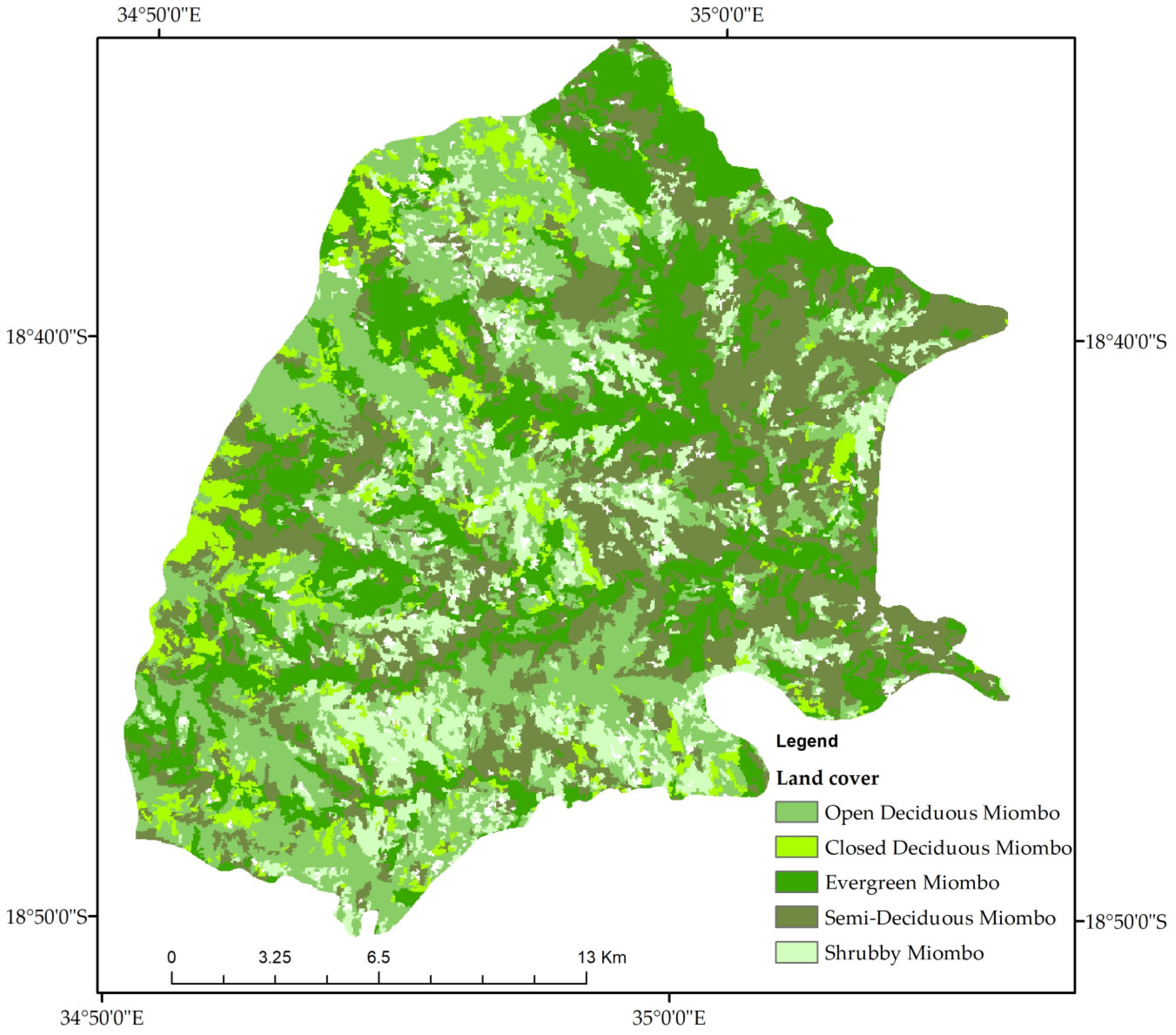
A validated land cover (LC) map was freely accessed through a geospatial database released by the Monitoring Report and Verification (MRV) department under the National Fund for Sustainable Development of Mozambique website (Figure 2). A description of this map can be found in FNDS [39]. The LC map was used to understand fire dynamics in the region, as vegetation is a key factor for fire occurrence analysis [19,20,21]. The LC names adopted in this manuscript are modifications of the LC names on the original map from the website. We performed these modifications based on the training data collected during the fieldwork. This allowed us to match the names from the map with the corresponding Miombo woodland types according to our field observations. We overlaid the national land cover map with the LFC boundary shapefile to identify LC types using remote sensing techniques [40]. Accordingly, seven cover types were identified: Open Deciduous Miombo (ODM), Close Deciduous Miombo (CDM), Semi Deciduous Miombo (SDM), Evergreen Miombo with Riverine forest (EGM), Grassland, Shrubby Miombo (SM), and Temporary Flooded Grassland (TFG). For this study, we only considered ODM, CDM, SDM, EGM and SM because these are the Miombo types encountered in the region. We excluded TFG and Grassland because the focus of our study is on Miombo.
The drivers of fire regime are linked to climate data, such as temperature, humidity, wind speed, and rainfall, which vary over and within years [19,20,21,29]. To understand how climate is related to fires in the LFC, we downloaded historical climate data in text format from https://power.larc.nasa.gov/data-access-viewer/ (accessed on 14 March 2024). The downloaded information included the average monthly and annual temperatures (°C), humidity (%), precipitation (mm), and wind speed (m/s) from 2001 to 2022. We obtained the data using seven random points (coordinates) representing the northern, northwestern, northeastern, southern, southeastern, southwestern, and central regions of the study area. Subsequently the daily climate data were converted to monthly and annual means for the analysis of fire occurrence dynamics in the LFC.
We also used complementary geographical data comprising LFC boundary shapefiles, such as rivers, roads, and local community locations, as inputs for GIS analysis. GPS burned area tracks (shapefile) collected on the ground were used for the validation of MODIS fire products (see details in Section 2.3.7).

2.3. Data Analysis

2.3.1. Fire Frequency and Fire Return Interval

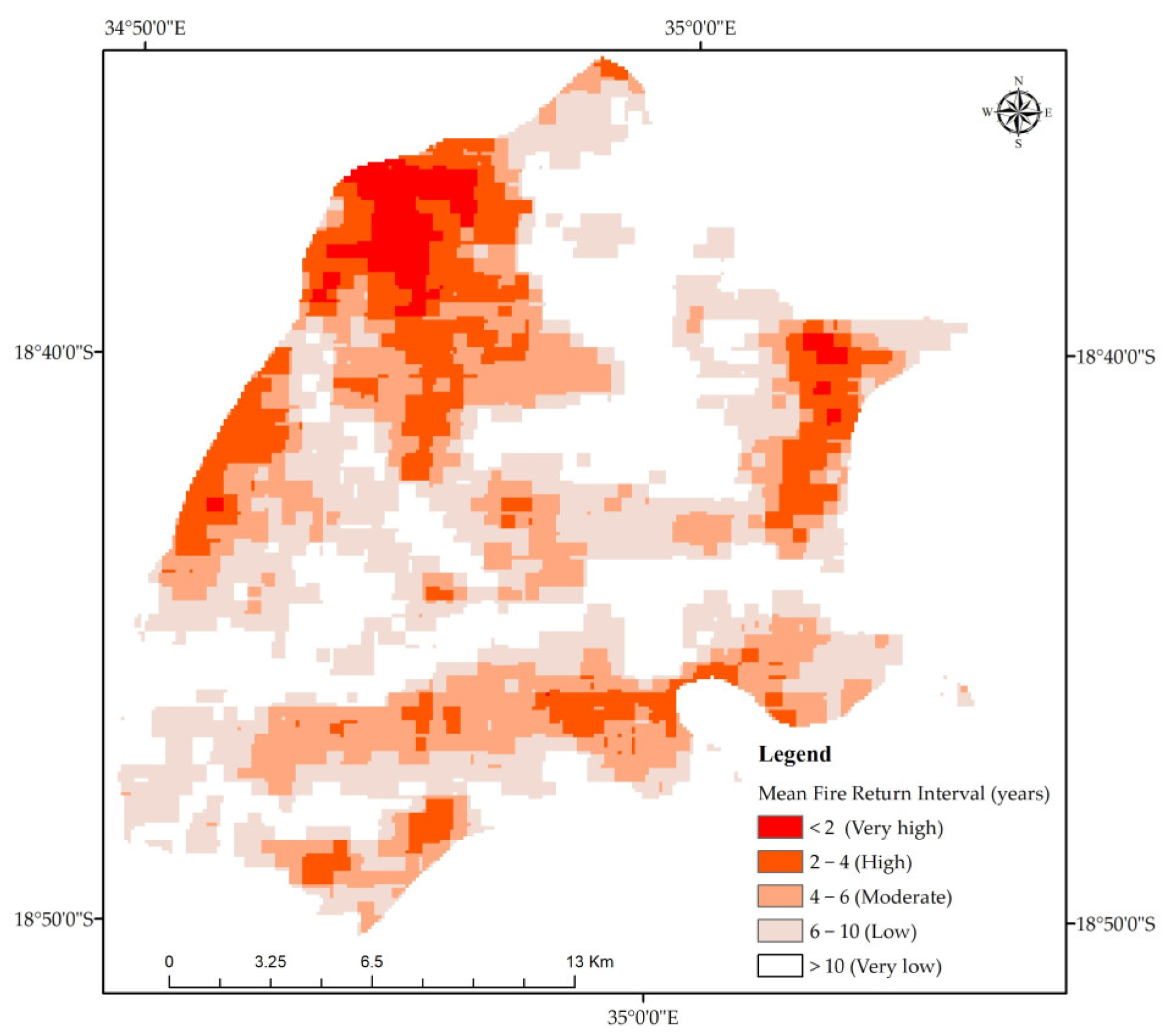
Fire frequency (FF) is the number of times a pixel burned consecutively during the 21 years of study [9,10,29]. To complement the fire frequency analysis, we computed the mean fire return interval (FRI), which is the inverse of FF [10]. FRI is described as a fire’s time to reoccur at a particular site [9,23,34]. Monthly MCD64 data were merged and summed in GIS to generate annual burned area maps. We used the overlay technique and the map algebra tool (raster calculator) in GIS to calculate annual burned area layers and generate the FF map. Additionally, we classified the FF map into five classes to generate the FRI map for the LFC during the study period. The FRI map observed the following thresholds defined according to studies on fire incidence in Miombo such as Ribeiro [9,10], Archibald et al. [20] and Magadzire [26]: very low (>10 years), low (6–10 years), moderate (4–6 years), high (2–4 years), and very high (<2 years). To compute FF, the following equation [11] was used:
FF = ni Ni ×   100
where FF represents fire frequency, ni equals the number of fire points in the study area and Ni is the total number of fires.
FRI was computed as proposed by Nieman et al. [34]:
FRI = y ( b a )
where FRI is the fire return interval in years, y is the number of years with fire records (21 years in this study), b is the extent of all fires over y years, and a refers to the area (46,000 ha) over which fires were recorded.

2.3.2. Fire Seasonality

We performed a seasonal assessment to evaluate intra-annual fire dynamics. We considered the late dry season (September up to October), early dry period (May to August) and the early rainy season (mid to late November up to December) for this assessment. These seasons are mentioned in Miombo fire regime-related studies by Ribeiro et al. [9], Ribeiro [10], Scholes and Andreae [12], Sinha et al. [13], Archibald et al. [20], Magadzire [26], and Zolho [27]. The MODIS Active fire data archive provides descriptions for the acquisition date of each fire. Burned area data are also offered in monthly grids. This information was combined to group fires according to the month of occurrence, which can be described as fire seasonality.

2.3.3. Fire Intensity

Active fires with an 80% confidence level were used to extract the fire radiative power (FRP). This variable has a linear relationship with fire intensity [38,41,42]. This is because FRP is mathematically calculated as the ratio between the brightness temperature of the fire and the background temperature of the pixel in the mid-infrared region, as described in Equation (3) [30,42,43]. Therefore, FRP was used to quantify the intensity of radiant heat detected by the MODIS products [18,34]. We calculated the mean FRP for each month in each year assessed and then extracted the data for further analysis. FRP is computed as follows [30,34].
FRP = 4.34   ×   10 19 ( T MIR 8     T bg MIR 8 )
where FRP is the rate of radiative energy emitted per pixel, 4.34 × 10⁻¹⁹ (MW km2 Kelvin8) is the counter derived from the simulations, TMIR is the temperature of the radiative glow of the fire component, Tbg MIR is the non-fire neighboring background component and MIR refers to the infrared wavelength which is typically 4 µm.

2.3.4. Fire Incidence and Land Cover

The burned area and land cover shapefile were overlaid using interpolation techniques in GIS to generate the fire incidence statistics by land cover type in the LFC. This technique allowed us to identify the vegetation types with the most affected fire frequencies during the 21 years assessed.

2.3.5. Fire Hotspot Analysis

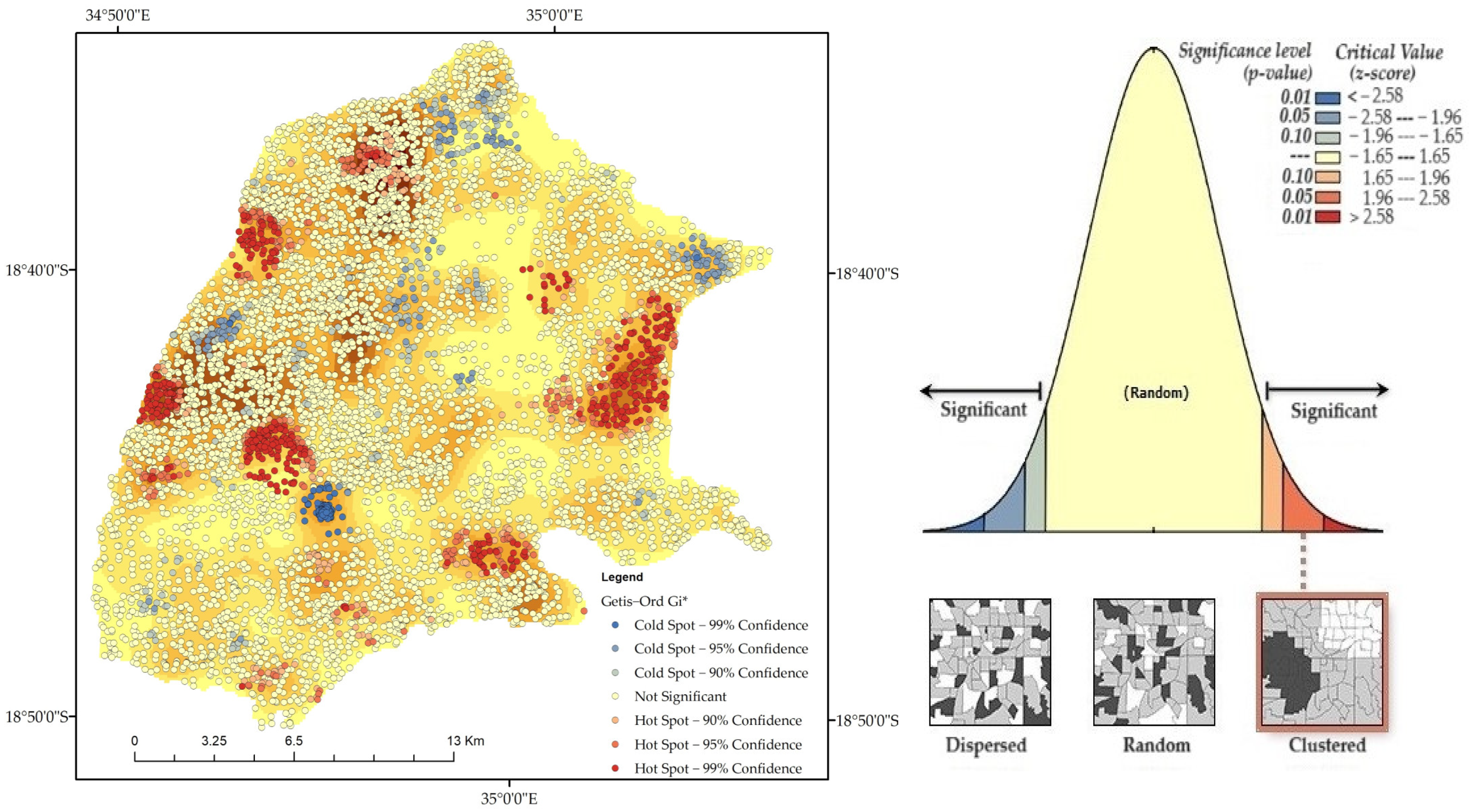
To analyze how fires were distributed in the region, hotspot analysis was conducted based on the Getis-Ord G* statistic [18,19,43,44]. For the dispersion and trend of fire occurrence data in clusters, spatial autocorrelation was performed in GIS. The hotspot analysis capabilities in ArcMap 10.5 were used to carry out the Gi* computations (Equation (4)). The Getis-Ord G* analysis estimates z-scores and p-values, which are important for drawing reliable conclusions [45]. Higher z-scores and lower p-values (Table 1) are reported in densely clustered fire patterns, whereas lower z-scores and lower p-values are found in highly scattered fire patterns [43,44,45,46]. The clustered pattern becomes less noticeable as the z-score approaches zero.
Gi * = j = 1 n w i , j x j j = 1 n w i , j n j = 1 n w 2 i , j ( j = 1 n w i , j ) 2 n 1 s
where i is the subject feature, xj is the attribute value for the neighbor feature j, and wi,j is the spatial weight between subject i,j and n is equal to the number of features.

2.3.6. The Influence of Environmental Factors on the Occurrence of Fires

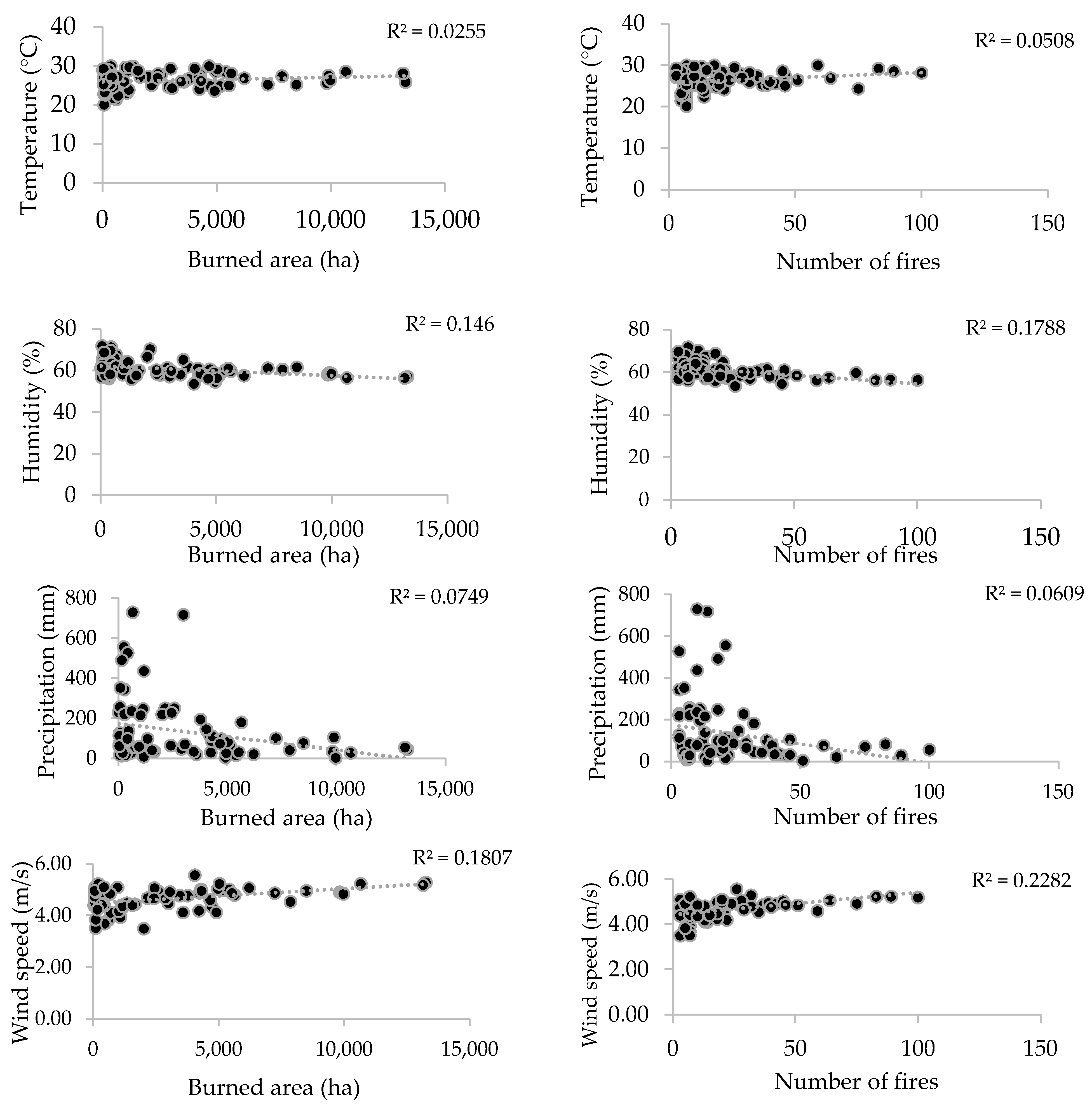
We investigated the relationship between climate data (precipitation, temperature, relative humidity, wind speed) and fire incidences (monthly burned area and active fires) using simple regression, as earlier studies indicate climate data as one of the main factors influencing fire dynamic [20,34,43]. This assessment helped us understanding how climate might explain the monthly variation of BA and AF in the LFC. Thus, we considered the dependent variables, the monthly BA and the monthly AF, while the climate data were considered the independent variables. The coefficient of determination (R2), residual distribution, and standard error were calculated to determine how well each independent variable could explain the variation of the dependent variables at a 95% confidence level.

2.3.7. Validation of the MODIS Products

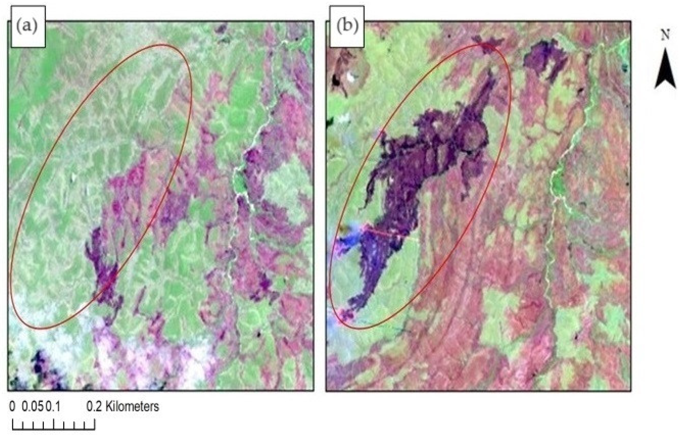
For the validation of the MODIS burned area product, and active fire product we applied an accuracy assessment analysis based on the confusion matrix. A confusion matrix, also known as an error matrix, is a method consisting of comparison of a remote sensing map, also known as classification map with a reference map, also considered as the ground truth [26]. This comparison allows to assess how classification map matches the ground truth [33]. We validated the classified burned area map by using Landsat series multispectral images combined with GPS burned area tracks collected on the ground. We could not access ground truth data to validate all 21 years accessed. For this reason, we combined both Landsat and data from LFC archive for conducting the assessment using available information from both sources. Thus, for this accuracy assessment we evaluated burned area data from 2017, 2018, 2019, 2020, and 2021. Detailed descriptions on the use of the Landsat multispectral images to validate MODIS burned area product MCD64 can be found in Giglio et al. [31] and Araújo et al. [33]. We downloaded the Landsat images for months with fire occurrence. We observed some missing data for both Landsat and LFC archive. We further discarded Landsat images with high percentage of clouds, because it was difficult to detect the burning scars. We used the ArcMap 10.5 software to combine bands in order to detect burn scars (Figure 3). The correct band combination included the visible, NIR and MIR as 7-4-2 [33,40]. Following band combinations, we digitalized the burn scars, and extracted shapefiles to compute the burned area in GIS.
Several variables were computed to construct the confusion matrix. Each of these variables represents a measurement of accuracy assessment according to Magadzire [26]: the Error of Omission (EO), which indicates the percentage of missed classification compared with the ground truth; the Error of Commission (EC), which indicates over-estimated classifications compared with the ground truth; the Producers Accuracy (PA), which refers to the proportion of reference data in a specific classification category, correctly classified; Consumers Accuracy (CA), the proportion of the classification area in specific category, correctly classified in the reference data; and Kappa coefficient (K), which measures the level of agreement between the classification map and the ground truth. We calculated K using the following formula:
K = observed   value     expected   value 1 expected   value
where observed value is equivalent to overall accuracy, and expected value is based on the chance agreement between the map under evaluation and the reference map. The expected value is computed as products of row and column values of a class in the confusion matrix [40]. The Kappa index values are classified as K < 0.0 (low agreement), 0.0–0.20 (poor agreement), 0.20–0.40 (moderate agreement), 0.40–0.60 (good agreement), 0.60–0.80 (very good agreement) and 0.8–1.0 (excellent agreement) [26,33].

3. Results

3.1. Annual Fire Incidence

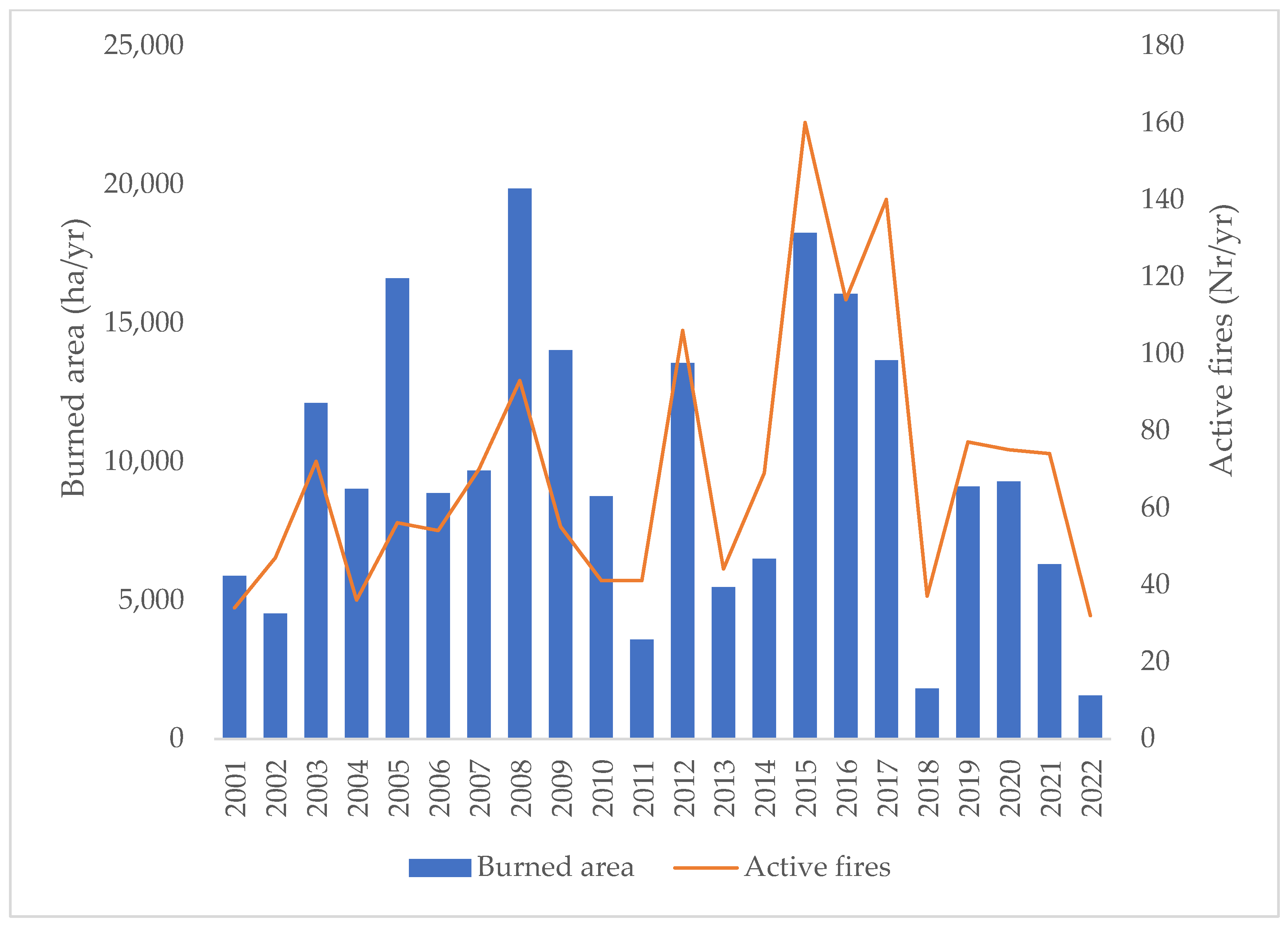
Our results on the burned area (BA) and active fire (AF) showed that around 88% (40,510 ha) of the LFC area experienced at least one instance of burning during the study period of 21 years. This resulted in a cumulative total BA of approximately 214,130 ha and 1527 AF, with an annual average of 9733 ha of BA and 69 AF. The annual BA varied from a minimum of 1547 ha (2022) to a maximum of 19,839 ha (2008), while the annual AF varied from a minimum of 32 detections (2022) to a maximum of 160 detections (2015). Figure 4 summarizes the annual statistics for BA and AF, indicating cyclic peaks (2001, 2003, 2005, 2008, 2012, 2015, and 2020) and valleys (2002, 2004, 2006, 2011, 2018, and 2022) of fire occurrences. Years with lower fire incidence were typically followed by higher fire incidences within three to five years.
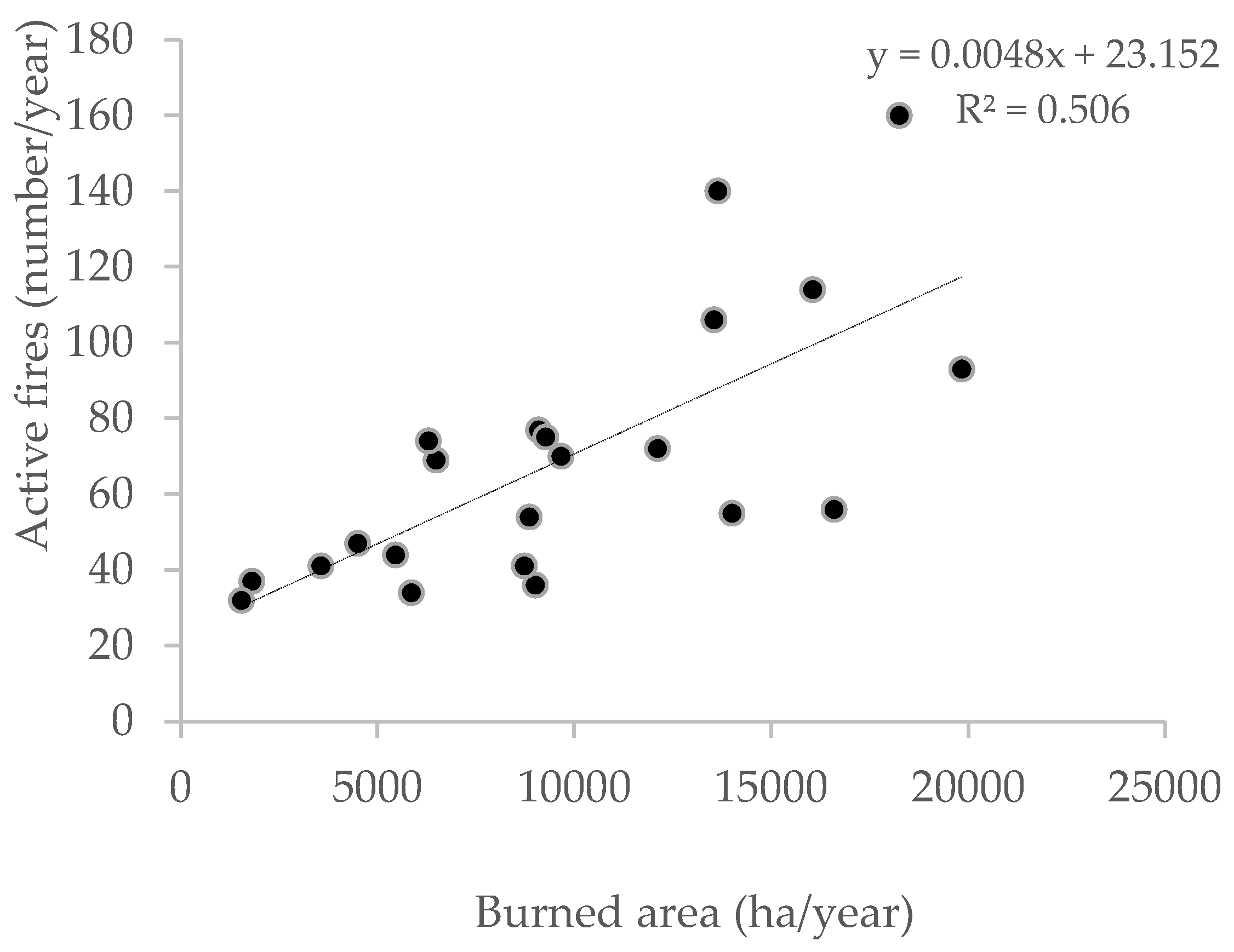
There was also a significant convergence between the distribution of the burned areas and clusters of active fires, indicating a positive and statistically significant correlation between these two variables (R2 = 0.51, p < 0.00001; Figure 5).
The monthly statistics for BA and AF are presented in Figure 6. The peak for both variables was observed in September (BA = 93,338 ha, AF = 606 fires), while the lowest values were observed in June (BA = 902 ha, AF = 4 fires). Late dry season fires accounted for 81.1% of BA and 78.1% of AF, followed by early dry season with 4.5% of BA and 6.2% of AF, and lastly, the early rainy season, which accounted for 14.2% of BA and 0.9% of AF.

3.2. Environmental Factors Explaining Burned Areas and Active Fires

The BA and AF varied significantly with some climate variables (p < 0.01). The mean temperature and the precipitation revealed a very weak capacity to explain the variations in BA and AF. However, humidity and the wind speed had a better explanatory capacity for BA and AF (Figure 7).

3.3. Fire Intensity

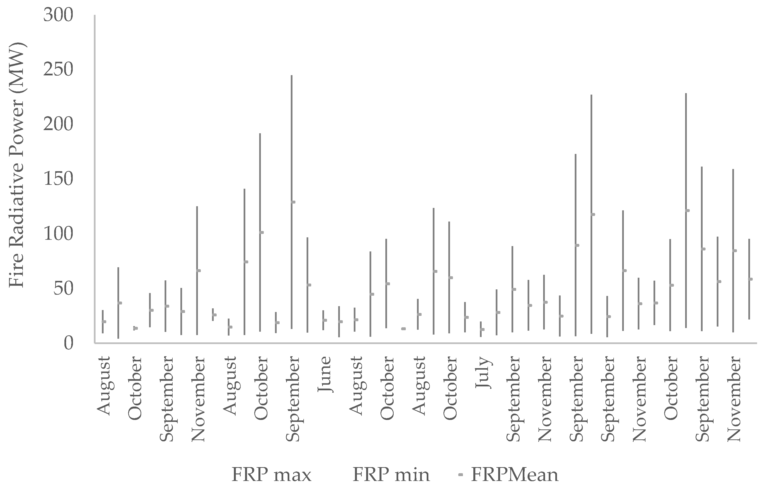
Fire intensity varies significantly (p < 0.05) and resembles fire seasonality, whereby fire intensity was low in the early dry season (mean = 20.6 MW), high in the late dry season (mean = 59.9 MW), and moderate in the early rainy season (mean = 48.67.1 MW) (Figure 8). Throughout the 21 years assessed, it was observed that fires were more intense in 2008 (sum = 5285.9 MW) and 2016 (sum = 3538.4 MW), and less intense in 2018 (sum = 412.6) and 2022 (sum = 646.3 MW). On a monthly basis, September and October experienced the hottest fires (Mean = 60.9 MW, Max = 179.5 MW and Mean = 58.1 MW, Max = 175.9 MW, respectively), while June had the lowest fire intensity (20.9 MW). These results demonstrate that fire intensity was proportionally related to the dry season.

3.4. Fire Frequency and Density from 2001 to 2022

The FF map in Figure 9 reveals that over the 21-year period (2001–2022), the FF in the LFC comprises very low (34%), low (30%) and moderate (20%) frequencies. High frequencies (2–4 years frequency) affected 13% of the pixels, and only 3% of the pixels experienced very high FF (<2 years). The overall average FRI for the entire study area was 4.43 years.

3.5. Fire Incidence and Land Cover

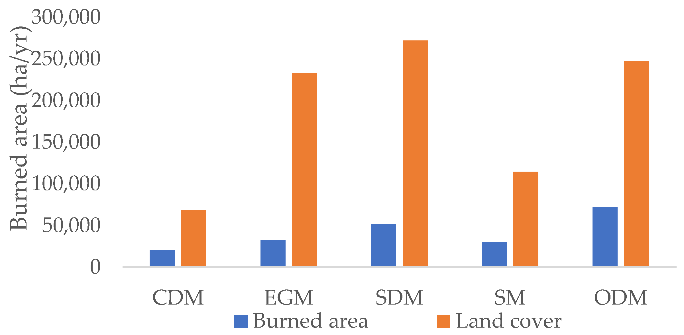
By intersecting the LC map with the BA map, it was observed that Open Deciduous Miombo (ODM) comprised approximately 35% of the BA, followed by Semi-Deciduous Miombo (25.1%) and Shrubby Miombo with 14.4% of the BA (Figure 10). These three LC types combined accounted for 74.4% of the BA. The remaining LC types, namely Evergreen Miombo and Close Deciduous Miombo, accounted for 15.7% and 9.9% of the BA, respectively. As indicated, fires in the LFC were more likely to occur in ODM. This prevalence is primarily due to the extensive area occupied by this LC type (Figure 2), which is bigger than the other land cover types.

3.6. Hotspot Analysis of Active Fires

The Getis-Ord Gi* analysis indicated that there was less than a 5% chance that the fires in LFC occurred by chance over the 21 years. Fires were distributed in clusters (Figure 11). The hotspot locations (z-score > 2.58, p = 0.01) coincided with areas of high FF. Conversely, regions with cold hotspot (z-score < −2.58, p = 0.01) corresponded to areas with the lowest FF (Figure 11).

4. Discussion

4.1. Fire Incidence in LFC

We observed oscillating patterns in terms of inter-annual fire incidence in the LFC (Figure 4). Findings from other studies such as Ribeiro [10] and Archibald et al. [20] suggest that this pattern could be related to biomass flux over the years of fire occurrence. The studies by Ribeiro [10], Magadzire [26], and Cangela [23] noted that the years most affected by burning, with a greater extent of the burned area, are followed by years with a low incidence of burning, likely due to the reduction in available biomass for burning. Notable picks in BA and AF were observed in 2005, 2008, 2015 and 2016. It is noteworthy that 2008, 2015, and 2022 were the warmest years since the pre-industrial era according to the World Meteorological Organization (WMO) [47]. Which can be an explanation of the high fire incidence observed in this years, but we did not test this relationship.

4.2. Fire Seasonality

Fires in the LFC comply with the dry season, beginning in June, increasing in September and October, and ending in December. These results provide clear evidence that fire occurrences are significantly associated with the increase in the dry season. These results are consistent with similar studies conducted in the Miombo woodland region, such as Naftal et al. [32] and Mpakair et al. [36]. A study conducted in Miombo by Sinha et al. [13] stated that a peak of fires was achieved from July to September. However, the main reason why fires occurred more frequently during the dry season was due to the decrease in humidity and increase in wind speed (Figure 7). Overall, humidity and wind speed show a better capacity to explain the variation of BA and AF. However, temperature and precipitation poorly explained the BA and AF (Figure 7). Findings from other studies, such as Kumar and Kumar’s [43], Dahan et al. [29] and Nieman et al. [34], indicated contrary results, whereby these factors are better correlated with BA and AF. We recommend further research on the correlation of climate data and BA and AF in LFC using data from local meteorological stations.
Supporting this observation, Ribeiro et al. [9] have identified that fires in the dry season are particularly destructive; not only due to their intensity (Figure 8) but also because their timing coincides with the period when woody plants have the lowest moisture content and leaves have senesced [48]. This condition increases the biomass as dry matter and facilitates greater thermal conductivity and a faster transfer of heat into plant tissues [48]. As highlighted in Figure 7, this pattern is observed because precipitation reduces the likelihood of fires [43] by decreasing the flammability of the combustible material [20].

4.3. Fires Incidence and Land Cover

The land cover type also plays a significant role in fire incidence in the LFC. Results illustrated in Figure 10 demonstrated that fires mostly affected the deciduous and relative open Miombo types, such as ODM, SDM and SM, while CDM and EGM were less affected by fires. According to Cangela [23], the unique combination of grass and tree structures in this Miombo category creates an appropriate environment for the ignition and spread of intense fires. The CDM and the EGM showed the least burned area over the 21 years assessed, as the moisture levels in closed forests are high and oxygen levels are low, which limits the spread of fires. However, some fires in impenetrable EGM canopy may not be detected by satellite imagery, as these fires are often superficial [26]. Also, it acknowledges that MODIS pixels’ spatial resolution might exclude small fires, this may be a reason to recommend further studies to apply remote sensing data (e.g., Sentinel mid-resolution images) that can detect small fires [49,50]. In contrast, although closed and evergreen Miombo had significant potential for fires in terms of fuel load, the spread of fires was limited due to moisture content in the fuel material, a high percentage of relative humidity, less wind speed, and lower temperature, as described by Archibald et al. [20], Kumar and Kumar [43], and Nieman et al. [34].

4.4. Fire Frequency and Return Interval

Although the overall FF in the area is within 4 to 22 years (84% of the area is affected either by low, very low or moderate FRI). We observed that 16% of pixels burnt within 1 to 4 years (high to very high FRI). High FRI raises the potential for fires to harm the ecosystem. Conducting a detailed study to evaluate the response of Miombo plant species to different FF is essential. The annual occurrence of fires is also a relevant indicator to assess whether fires in Miombo are a significant source of GHG emissions or not. Thus, a detailed study on this subject in the LFC is also recommended. As observed by Ryan and Williams [22], FF may not be a problem for forest management in the LFC since, according to the same authors, frequent fires might not necessarily mean significant destruction for the ecosystem. However, for Kall [6] and Magadzire [26], intense fires are the real problem, since intensity increases the potential of disturbance from fires. Fires in the region can be highly intense compared to the studies conducted in Miombo, such as Nieman et al. [34], which may be due to the high level of biomass accumulated in the region in the form of dry matter [5]. Thus, it is important that management activities keep focusing on reducing fire intensity rather than FF, which is proven to not be a problem for the region.
The FF findings in this study are in line with findings from other studies conducted in similar ecosystems. For example, the studies by Archibald et al. [20] referred to the average FRI in savannah and grassland ecosystems, which include Miombo woodlands, ranging from 1.7 to 10 years. Ribeiro et al. [9], Ribeiro [10], Cangela [23], Saito et al. [51], Lourenço et al. [52], Van Wilgen [53] have reported that the FRI for Miombo ranges between 1.6 and 4.5 years. Thus, the FRI of 4.43 found in this study is considered to be within the common range for miombo woodland and it is classified as moderate, as stated by Magadzire [26]. According to Archibald et al. [20], FRI variations are related to factors like precipitation and human activities in the region. For example, in semi-arid savannas where there is less rainfall, FRIs can extend up to 50 years [15]; whereas in humid savannas like the humid Miombo, FRI can vary between 1 and 10 years based on the studies previously mentioned.

4.5. Hotspot Analysis

The spatial distribution of fire hotspot in the LFC, highlighted in Figure 11, shows a tendency for fires to occur in areas with high anthropogenic influences, such as proximity to roads, residential settlements, hunting, and agricultural areas. Notably, this suggests that there might be a correlation between the extent of burned areas and population density. This relationship should be part of future studies theme in LFC. However, other studies in the region conducted by Buramuge et al. [17] and Zolho [27] further support the conclusion that fires in the region are predominantly man-made, as they found a high correlation between fires and anthropogenic areas near settlements.

4.6. Accuracy Assessment of MODIS-Derived Burned Area Maps

The use of MCD64 and MCD14ML proved advantageous since the fire history was properly evaluated with these data. It is important to note that the combination of the MCD14ML and MCD64 products provides added value, as it allows for greater scope in the identification of fire outbreaks. In other words, both products complement each other, and the global accuracy test proved good agreement between MODIS-derived maps and the ground truth data (Kappa index value of 58%). The overall accuracy of the classification (P0 = 80.4%) indicates that the mapping of burned areas and fire hotspots using MCD46 and MCD14ML in this study closely matches field observations. However, it is estimated that 8% of the burned areas were not detected (omission errors), and an additional 12% were incorrectly identified as burned (commission errors).
The omission errors could be attributed to the MODIS sensor’s limitation in detecting burnings smaller than 500 m2 [26,50]. Alternatively, these errors might also arise from the MODIS sensor’s capacity to provide only single pass data per day [18,38,54], potentially missing fires that occurred after the satellite’s pass. Moreover, in equatorial regions, the orbital path of the sensor may only allow for observation once every two days [50]. Omission errors are likely due to the convergence of orbit bands at high latitudes, increasing the possibility of multiple detections of the same fire. Furthermore, the combined use of Terra and Aqua satellites can lead to repeated detections of the same fire in high-latitude areas [30].

5. Conclusions

The presence of fires in the Miombo woodlands is an undeniable ecological factor. However, their incidence and impact on this ecosystem are not well understood. This research provides a robust 21-year evaluation of the spatio-temporal fire regime and patterns in Miombo woodlands, specifically focusing on the 46,000 ha LevasFlor Forest Concession (LFC) in Central Mozambique. We used MODIS datasets, including the burned area product (MCD64) and the active fire product (MCD14ML), to characterize fire regimes, dynamics, and spatial patterns essential for understanding and managing fires in this ecosystem. Our findings highlight the critical role of remote sensing in enhancing fire management strategies and improving knowledge of fire dynamics across the vast Miombo woodlands in central Mozambique and African savannas. It also provides a perspective on the effectiveness of fire management practices in the LFC area. Despite the low frequency of fires, their annual occurrence in the LFC represents a potential risk to the perpetuity of the ecosystem. The LFC managers can significantly improve their fire management strategies by focusing on the regions identified as fire hotspots, as these are potential sources of fire outbreaks. Fire intensity in the region is relatively high, campaigns of cold burning as a fire management action are highly recommended as they prevent destructive fires. The low fire frequency observed in the study area suggests that plant species may be resilient to fire. However, the potential impact of fires on greenhouse gas (GHG) emissions remains unclear. Therefore, further research on the ecological responses to different fire frequencies and the impact of fires on GHG emission in the region is recommended for future studies.

Author Contributions

Conceptualization, O.M.M., N.S.R., Z.S. and S.M.A.; formal analysis, O.M.M., N.S.R., Z.S. and S.M.A.; methodology, O.M.M., N.S.R., Z.S. and S.M.A.; supervision, N.S.R., Z.S. and S.M.A.; validation N.S.R., Z.S. and S.M.A.; writing—original draft, O.M.M.; writing—review and editing, O.M.M., N.S.R., Z.S. and S.M.A. All authors have read and agreed to the published version of the manuscript.

Funding

This research was funded by Swedish International Development Cooperation Agency (SIDA), under the program Regional Research School in Forest Sciences (REFOREST), grant number 13394.

Institutional Review Board Statement

Not applicable.

Informed Consent Statement

Informed consent was allowed for all subjects considered in the research.

Data Availability Statement

Data will be made available upon reasonable request from the corresponding author.

Acknowledgments

We gratefully acknowledge Manuel Carlos Pedroso, field assistant, and Jaime Couto, staff from Levasflor Forest Concession, for their crucial support during the data collection, which made this work possible.

Conflicts of Interest

The authors declare that they have no known competing financial interests or personal relationships that could have influence on this work.

References

  1. Ribeiro, N.S.; Armstrong, A.H.; Fischer, R.; Kim, Y.S.; Shugart, H.H.; Ribeiro-Barros, A.I.; Chauque, A.; Tear, T.; Washington-Allen, R.; Bandeira, R.R. Prediction of forest parameters and carbon accounting under different fire regimes in Miombo woodlands, Niassa Special Reserve, Northern Mozambique. For. Policy Econ. 2021, 133, 102625. [Google Scholar] [CrossRef]
  2. Joaquim-Meque, E.; Lousada, J.; Liberato, M.L.R.; Fonseca, T.F. Forest in Mozambique: Actual Distribution of Tree Species and Potential Threats. Land 2023, 12, 1519. [Google Scholar] [CrossRef]
  3. Sitoe, A.; Salomão, A.; Wertz-Kanounnikoff, S. The Context of REDD+ in Mozambique: Drivers, Agents and Institutions; CIFOR: Bogor, Indonesia, 2012; 79p. [Google Scholar]
  4. Bila, J.M.; Sanquetta, C.R.; Corte, A.P.D.; De Freitas, L.J.M. Diametric distribution and main tree species present in the Miombo, Mopane and Mecrusse ecosystems in Mozambique. Braz. For. Res. 2018, 38, e201701523. [Google Scholar] [CrossRef]
  5. Chidumayo, E.N. Miombo Ecology and Management: An Introduction; Stockholm Environment Institute: Stockholm, Sweden, 1997; 166p. [Google Scholar]
  6. Käll, K. The role of fire in the Miombo forest: And the adaptation of the Community-based forest management to meet local needs. Environ. Sci. 2006, 24. [Google Scholar]
  7. Timberlake, J.; Chidumayo, E.; Sawadogo, L. Distribution and characteristics of African dry forests and woodlands. In The Dry Forests and Woodlands of Africa; Routledge: England, UK, 2010; pp. 11–41. [Google Scholar]
  8. Frost, P. The Ecology of Miombo Woodlands. In The Miombo in Transition: Woodlands and Welfare in Africa; Campbell, B.M., Ed.; CIFOR: Bogor, Indonesia, 1996; pp. 11–57. [Google Scholar]
  9. Ribeiro, N.S.; Cangela, A.; Chauque, A.; Bandeira, R.R.; Ribeiro, A. Characterisation of spatial and temporal distribution of the fire regime in Niassa National Reserve, northern Mozambique. Int. J. Wildland Fire 2017, 26, 1021–1029. [Google Scholar] [CrossRef]
  10. Ribeiro, N.S. Interaction between Fires and Elephants in Relation to Vegetation Structure and Composition of Miombo Woodlands in Northern Mozambique. Ph.D. Thesis, University of Virginia, Charlottesville, VA, USA, 2007; 234p. [Google Scholar]
  11. Hoffmann, A.A.; Parry, J.E.; Cuambe, C.C.D.; Kwesha, D.; Zhakata, W. Climate change and wildland fires in Mozambique. In Tropical Fire Ecology: Climate Change, Land Use, and Ecosystem Dynamics; Springer: Berlin/Heidelberg, Germany, 2009; pp. 227–259. [Google Scholar]
  12. Scholes, M.; Andreae, M.O. Biogenic and pyrogenic emissions from Africa and their impact on the global atmosphere. Ambio 2000, 29, 23–29. [Google Scholar] [CrossRef]
  13. Sinha, P.; Hobbs, P.V.; Yokelson, R.J.; Blake, D.R.; Gao, S.; Kirchstetter, T.W. Emissions from Miombo woodland and Dambo grassland savanna fires. J. Geophys. Res. Atmos. 2004, 109, 1–13. [Google Scholar] [CrossRef]
  14. Wilson, S.A.; Scholes, R.J. The climate impact of land use change in the Miombo region of south-central Africa. J. Integr. Environ. Sci. 2020, 17, 187–203. [Google Scholar] [CrossRef]
  15. Jew, E.K.; Dougill, A.J.; Sallu, S.M.; O’Connell, J.; Benton, T.G. Miombo woodland under threat: Consequences for tree diversity and carbon storage. For. Ecol. Manag. 2016, 361, 144–153. [Google Scholar] [CrossRef]
  16. Wingqvist, O.G. Environment and Climate Change Policy Brief—Mozambique; Swedish Agency for International Development Cooperation Swedish: Stockholm, Sweden; University of Agricultural Sciences: Uppsala, Sweden; University of Gothenburg: Chalmers, Sweden, 2011; 23p. [Google Scholar]
  17. Buramuge, V.A.; Ribeiro, N.S.; Olsson, L.; Bandeira, R.R. Exploring Spatial Distributions of Land Use and Land Cover Change in Fire-Affected Areas of Miombo Woodlands of the Beira Corridor, Central Mozambique. Fire 2023, 6, 77. [Google Scholar] [CrossRef]
  18. Gajović, V.; Todorović, B. Spatial and temporal analysis of fires in Serbia for period 2000–2013. J. Geogr. Inst. Jovan Cvijic SASA 2013, 63, 297–312. [Google Scholar] [CrossRef]
  19. Reddy, C.S.; Bird, N.G.; Sreelakshmi, S.; Manikandan, T.M.; Asra, M.; Krishna, P.H.; Diwakar, P.G. Identification and characterization of spatio-temporal hotspots of forest fires in South Asia. Environ. Monit. Assess. 2019, 191, 1–17. [Google Scholar] [CrossRef] [PubMed]
  20. Archibald, S.; Roy, D.P.; van Wilgen, B.W.; Scholes, R.J. What limits fire? An examination of drivers of burnt areas in southern Africa. In: Fire Regimes in Southern Africa-Determinants, Drivers and Feedbacks. Glob. Change Biol. 2010, 15, 613–630. [Google Scholar] [CrossRef]
  21. Dwyer, E.; Pereira, J.M.; Grégoire, J.M.; DaCamara, C.C. Characterization of the spatio-temporal patterns of global fire activity using satellite imagery for the period April 1992 to March 1993. J. Biogeogr. 2000, 27, 57–69. [Google Scholar] [CrossRef]
  22. Ryan, C.M.; Williams, M. How does fire intensity and frequency affect Miombo woodland tree populations and biomass? Ecol. Appl. 2011, 21, 48–60. [Google Scholar] [CrossRef] [PubMed]
  23. Cangela, A.D.C.N.P. Caracterização e Mapeamento do Regime de Queimadas na Reserva Nacional do Niassa. Master’s Thesis, UEM, Maputo, Mozambique, 2014; 72p. [Google Scholar]
  24. Ministério da Terra, Ambiente e Desenvolvimento Rural (MITADER). Mozambique’s Forest Reference Emission Level for Reducing Emissions from Deforestation in Natural Forests, 10th ed.; República de Moçambique. Ministério da Terra, Ambiente e Desenvolvimento Rural: Maputo, Mozambique, 2018; 50p. [Google Scholar]
  25. Direcção Nacional De Florestas (DNAF). Inventário Florestal Nacional; relatório final; República De Moçambique Ministério Da Terra, Ambiente E Desenvolvimento Rural, Direcção Nacional De Florestas: Maputo, Mozambique, 2018; 118p. [Google Scholar]
  26. Magadzire, N. Reconstruction of a Fire Regime Using MODIS Burned Area Data: Charara Safari Area, Zimbabwe. Ph.D. Thesis, Stellenbosch University, Stellenbosch, South africa, 2013; 85p. [Google Scholar]
  27. Zolho, R. Effect of Fire Frequency on the Regeneration of Miombo Woodland in Nhambita, Mozambique. Master’s Thesis, Science University of Edinburgh, Scotland, UK, 2005; 63p. [Google Scholar]
  28. Tarimo, B.; Dick, Ø.; Gobakken, T.; Totland, O. Spatial distribution of temporal dynamics in anthropogenic fires in Miombo savanna woodlands of Tanzania. Carbon Balance Manag. 2015, 10, 18. [Google Scholar] [CrossRef] [PubMed]
  29. Dahan, K.S.; Kasei, R.A.; Husseini, R. Contribution of remote sensing to wildfire trend and dynamic analysis in two of Ghana’s ecological zones: Guinea-savanna and Forest-savanna mosaic. Fire Ecol. 2023, 19, 42. [Google Scholar] [CrossRef]
  30. Justice, C.O.; Giglio, L.; Korontzi, S.; Owens, J.; Morisette, J.T.; Roy, D.; Descloitres, J.; Alleaume, S.; Petitcolin, F.; Kaufman, Y. The MODIS fire products. Remote Sens. Environ. 2002, 83, 244–262. [Google Scholar] [CrossRef]
  31. Giglio, L.A.; Humber, M.; Hall, J.V.; Argueta, F. Collection 6.1 MODIS Burned Area Product User’s Guide Version 1.1; NASA EOSDIS Land Processes DAAC: Sioux Falls, SD, USA, 2022; pp. 11–27. [Google Scholar]
  32. Naftal, B.; Kija, H.K.; William, C.; Noe, C.; Anderson, D.; Stewart, F.A.; Piel, A.K. Spatial and temporal pattern of wildfires in the Masito Ugalla Ecosystem (2008–2019). IOSR J. Environ. Sci. Toxicol. Food Technol. 2022, 16, 12–19. [Google Scholar] [CrossRef]
  33. Araújo, F.D.; Ferreira, L.G., Jr. Validação do produto MODIS MCD45A1 área queimada utilizando imagens LANDSAT TM para o bioma Cerrado. In Proceedings of the Simpósio Brasileiro de Sensoriamento Remoto, Curitiba, PR, Brasil, 30 April–5 May 2011; pp. 6410–6417. [Google Scholar]
  34. Nieman, W.A.; Van Wilgen, B.W.; Leslie, A.J. A reconstruction of the recent fire regimes of Majete Wildlife Reserve, Malawi. Fire Ecol. 2021, 17, 36. [Google Scholar] [CrossRef]
  35. Chaúque, M. Plano de Maneio Florestal Para a Concessão Florestal de Condue, distritos de Muanza e Cheringoma; Ministry of Land and Enviroment: Maputo, Mozambique, 2020; 76p. [Google Scholar]
  36. Mpakairi, K.S.; Tagwireyi, P.; Ndaimani, H.; Madiri, H.T. Distribution of wildland fires and possible hotspots for the Zimbabwean Kavango-Zambezi Transfrontier Conservation Area component. South Afr. Geogr. J. 2019, 101, 110–120. [Google Scholar] [CrossRef]
  37. Zahran, E.S.M.M.; Shams, S.; Said, S.N.B.M.; Zahran, E.S.M.M.; Gadong, B.; Brunei-Muara, B.D. Validation Of Forest Fire Hotspot Analysis In Gis Using Forest Fire Contributory Factors. Syst. Rev. Pharm. 2020, 11, 249–255. [Google Scholar]
  38. Oom, D.; Pereira, J.M. Exploratory spatial data analysis of global MODIS active fire data. Int. J. Appl. Earth Obs. Geoinf. 2013, 21, 326–340. [Google Scholar] [CrossRef]
  39. FNDS. Relatório do Mapa de Cobertura Florestal de Moçambique de 2016; FNDS: Maputo, Mozambique, 2019; 100p. [Google Scholar]
  40. Campbell, J.; Wayne, R. Introduction to Remote Sensing, 5th ed.; The Guilford Press: New York, NY, USA, 2011; 701p. [Google Scholar]
  41. Kaiser, J.W.; Heil, A.; Andreae, M.O.; Benedetti, A.; Chubarova, N.; Jones, L.; Van Der Werf, G.R. Biomass burning emissions estimated with a global fire assimilation system based on observed fire radiative power. Biogeosciences 2012, 9, 527–554. [Google Scholar] [CrossRef]
  42. Vadrevu, K.P.; Csiszar, I.; Ellicott, E.; Giglio, L.; Badarinath, K.V.S.; Vermote, E.; Justice, C. Hotspot analysis of vegetation fires and intensity in the Indian region. IEEE J. Sel. Top. Appl. Earth Obs. Remote Sens. 2013, 6, 224–238. [Google Scholar] [CrossRef]
  43. Kumar, S.; Kumar, A. Hotspot and trend analysis of forest fires and its relation to climatic factors in the western Himalayas. Nat. Hazards 2022, 114, 3529–3544. [Google Scholar] [CrossRef]
  44. Aftergood, O.; Flannigan, M. Identifying and analyzing spatial and temporal patterns of lightning-ignited wildfires in Western Canada from 1981–2018. Can. J. For. Res. 2022, 52, 1399–1411. [Google Scholar] [CrossRef]
  45. Chen, C.Y.; Yang, Q.-H. Hotspot Analysis of the Spatial and Temporal Distribution of Fires. In Proceedings of the GISTAM 2018—4th International Conference on Geographical Information Systems Theory, Applications and Management, Funchal, Portugal, 17–19 March 2018; pp. 15–21. [Google Scholar] [CrossRef]
  46. Rossi, F.; Becker, G. Creating forest management units with Hot Spot Analysis (Getis-Ord Gi*) over a forest affected by mixed-severity fires. Aust. For. 2019, 82, 166–175. [Google Scholar] [CrossRef]
  47. World Metereological Organization. Past Eight Years Confirmed to Be the Eight Warmest on Record. 2023. Available online: https://public.wmo.int/en/media/press-release/past-eight-years-confirmed-be-eight-warmest-record (accessed on 12 December 2023).
  48. Frost, P.; Robertson, F. The ecological role of fire in savannas. Determinants of Tropical Savannas. In The International Union of Biological Sciences; IRL Press: Oxford, UK, 1987; pp. 93–140. [Google Scholar]
  49. Shirvani, Z.; Abdi, O.; Goodman, R.C. High-Resolution Semantic Segmentation of Woodland Fires Using Residual Attention UNet and Time Series of Sentinel-2. Remote Sens. 2023, 15, 1342. [Google Scholar] [CrossRef]
  50. Leblon, B.; San, J.; Bourgeau-Chavez, L. Use of remote sensing in wildfire management. Chapter 3. In Sustainable Development-Authoritative and Leading Edge Content for Environmental Management; Western Michigan University: Sime Curkovic, MI, USA, 2012; pp. 57–81. [Google Scholar] [CrossRef]
  51. Saito, M.; Luyssaert, S.; Poulter, B.; Williams, M.; Ciais, P.; Bellassen, V.; Ryan, C.M.; Yue, C.; Cadule, P.; Peylin, P. Fire regimes and variability in aboveground woody biomass in miombo woodland. Journal of Geophysical Research. Biogeosciences 2014, 119, 1014–1029. [Google Scholar] [CrossRef]
  52. Lourenco, M.; Woodborne, S.; Fitchett, J.M. Fire regime of peatlands in the Angolan Highlands. Environ. Monit. Assess. 2023, 195, 78. [Google Scholar] [CrossRef] [PubMed]
  53. Van Wilgen, B.W.; De Klerk, H.M.; Stellmes, M.; Archibald, S. An analysis of the recent fire regimes in the Angolan catchment of the Okavango Delta, Central Africa. Fire Ecol. 2022, 18, 13. [Google Scholar] [CrossRef]
  54. Kaufman, Y.J.; Ichoku, C.; Giglio, L.; Korontzi, S.; Chu, D.A.; Hao, W.M.; Justice, C.O. Fire and smoke observed from the Earth Observing System MODIS instrument—Products, validation, and operational use. Int. J. Remote Sens. 2003, 24, 1765–1781. [Google Scholar] [CrossRef]
Figure 1. Geographic location of the study area within the LevasFlor Forest Concession, Central Mozambique.
Fire 07 00264 g001
Figure 2. Land cover map showing different miombo types in the LevasFlor Forest Concession, Central Mozambique available at the Geospatial MRV platform, at https://www.arcgis.com/apps/webappviewer/index.html?id=1e201cf974584b38ac5dd92b005c99a (accessed on 6 September 2023).
Fire 07 00264 g002
Figure 3. Band combination (7-4-2) before and after fire occurrence captured in May 2015 (a) and in September 2015 (b), in the LevasFlor Concession, Central Mozambique.
Fire 07 00264 g003
Figure 4. Inter-annual variation of burned area and active fires from 2001 to 2022 in the LevasFlor Forest Concession, Central Mozambique.
Fire 07 00264 g004
Figure 5. Relationship between the number of fires and burned area detected from 2001 to 2022 in the LevasFlor Forest Concession, Central Mozambique.
Fire 07 00264 g005
Figure 6. Monthly variation of burned areas and active fires from 2001 to 2022 in the LevasFlor Forest Concession, Central Mozambique.
Fire 07 00264 g006
Figure 7. Relationship between the average monthly-burned area, active fires and the mean temperature, relative humidity, average monthly precipitation, and wind speed in the LevasFlor Forest Concession, Central Mozambique.
Fire 07 00264 g007
Figure 8. Monthly variation of fire intensity (fire radiative power) in the LevasFlor Forest Concession, Central Mozambique.
Fire 07 00264 g008
Figure 9. Mean fire return interval map for the period 2001 to 2022 in the LevasFlor Forest Concession, Central Mozambique.
Fire 07 00264 g009
Figure 10. Cumulative (2001–2022) burned area (blue) in comparison to the land cover area (orange) in the LevasFlor Forest Concession, Central Mozambique.
Fire 07 00264 g010
Figure 11. Fire hotspot and coldspot clusters in the LevasFlor Forest Concession, Central Mozam-bique.
Fire 07 00264 g011
Table 1. Hotspot and coldspot Gi* score values and confidence from cluster analysis during 2001–2022 in LevasFlor Forest Concession, Central Mozambique.
Cluster TypeGi* z-ScoresConfidence (%)
Hotspot>1.6590
>1.9695
>2.5899
Cold spot<−1.65
<−1.96
90
95
<−2.5899
Disclaimer/Publisher’s Note: The statements, opinions and data contained in all publications are solely those of the individual author(s) and contributor(s) and not of MDPI and/or the editor(s). MDPI and/or the editor(s) disclaim responsibility for any injury to people or property resulting from any ideas, methods, instructions or products referred to in the content.