Article

Forest Fragmentation and Fires in the Eastern Brazilian Amazon–Maranhão State, Brazil

by
Celso H. L. Silva-Junior
1,2,3,*,†,
Arisson T. M. Buna
4,†,
Denilson S. Bezerra
5,†,
Ozeas S. Costa, Jr.
6,
Adriano L. Santos
5,
Lidielze O. D. Basson
5,
André L. S. Santos
7,
Swanni T. Alvarado
3,
Catherine T. Almeida
8,
Ana T. G. Freire
5,
Guillaume X. Rousseau
3,
Danielle Celentano
3,9,
Fabricio B. Silva
4,
Maria S. S. Pinheiro
5,
Silvana Amaral
10,
Milton Kampel
10,
Laura B. Vedovato
11,
Liana O. Anderson
12 and
Luiz E. O. C. Aragão
10,11
1
Institute of Environment and Sustainability, University of California, Los Angeles, CA 90095, USA
2
Jet Propulsion Laboratory, California Institute of Technology, Pasadena, CA 91011, USA
3
Departamento de Engenharia Agrícola, Universidade Estadual do Maranhão—UEMA, São Luís 65000-000, MA, Brazil
4
Mestrado em Meio Ambiente, Universidade CEUMA—UniCEUMA, São Luís 65075-120, MA, Brazil
5
Departamento de Oceanografia e Limnologia, Universidade Federal do Maranhão—UFMA, São Luís 65080-805, MA, Brazil
6
School of Earth Sciences, The Ohio State University, Mansfield, OH 43210, USA
7
Instituto Federal do Maranhão—IFMA, São Luís 65030-005, MA, Brazil
8
Escola Superior de Agricultura Luiz de Queiroz, Universidade de São Paulo—USP, Piracicaba 13418-900, SP, Brazil
9
Conservação Internacional—CI, Brasília 70711-902, DF, Brazil
10
Instituto Nacional de Pesquisas Espaciais—INPE, São José dos Campos 12227-010, SP, Brazil
11
College of Life and Environmental Sciences, Geography, University of Exeter, Exeter EX4 4PY, UK
12
Centro Nacional de Monitoramento e Alertas de Desastres Nacionais—CEMADEN, São José dos Campos 12630-000, SP, Brazil
*
Author to whom correspondence should be addressed.
These authors contributed equally to this work.
Submission received: 17 April 2022 / Revised: 28 May 2022 / Accepted: 31 May 2022 / Published: 5 June 2022
(This article belongs to the Special Issue Vegetation Fires in South America)

Abstract

:
Tropical forests provide essential environmental services to human well-being. In the world, Brazil has the largest continuous area of these forests. However, in the state of Maranhão, in the eastern Amazon, only 24% of the original forest cover remains. We integrated and analyzed active fires, burned area, land use and land cover, rainfall, and surface temperature datasets to understand forest fragmentation and forest fire dynamics from a remote sensing approach. We found that forest cover in the Maranhão Amazon region had a net reduction of 31,302 km2 between 1985 and 2017, with 63% of losses occurring in forest core areas. Forest edges extent was reduced by 38%, while the size of isolated forest patches increased by 239%. Forest fires impacted, on average, around 1031 ± 695 km2 year−1 of forest edges between 2003 and 2017, the equivalent of 60% of the total burned forest in this period. Our results demonstrated that forest fragmentation is an important factor controlling temporal and spatial variability of forest fires in the eastern Amazon region. Thus, both directly and indirectly, forest fragmentation can compromise biodiversity and carbon stocks in this Amazon region.

1. Introduction

Tropical forests provide essential environmental services to human well-being, including the storage of biodiversity and carbon [1,2,3,4]. The Amazon rainforest is the largest tropical forest globally, covering almost 7 million square kilometers, and extending into nine countries in South America (Brazil, Peru, Colombia, Venezuela, Ecuador, Bolivia, Guyana, Suriname, and French Guiana) [5]. Brazil holds the largest continuous area of forest in the region—around 60% of the Amazon basin [5]—distributed over nine federative units. One of these units, the state of Maranhão, had an original old-growth forest cover of 110,400 km2 (around 33% of the state’s territory) [6]. This region is part of the Belém Endemism Center, where around 30 species of animals and plants are on the endangered species list [7]. Large-scale deforestation since the mid-1960s—primarily for agriculture and cattle ranching—has resulted in the loss of a significant portion of the original forest cover in the Maranhão Amazon [6,8], and only around 23,967 km2 (24%) remains (up until 2019) [9]. Maranhão has the second-highest level of forest fragmentation among all states in the Brazilian Legal Amazon, with almost 74% of the area represented in the non-core fragmentation category [10].
Deforestation alters the spatial configuration of forest cover through fragmentation, increasing the edge areas, and reducing the connectivity of the core remnants [11,12,13]. Among other negative impacts [12,14], fragmentation makes the forest more susceptible to fire due to the edge effects [13,15,16]. Forest edges and small forest patches have suitable conditions for the spread of fire, including a drier and hotter microclimate, abundant availability of fuel (necromass) in the understory, and greater exposure to ignition sources, since they are surrounded by agricultural and livestock areas [13,15,17,18,19,20].
Although the fire dynamics are well-documented in other biomes of Maranhão [21,22,23,24,25], little is known about the forest fires and their relationship with forest fragmentation in the Amazon biome of the state. Moreover, extreme droughts combined with anthropogenic ignition sources [26], such as land management fires, deforestation fires, and arson fires, have caused fires to spread uncontrollably through the Amazon forests [6,27,28,29,30]. This synergy between highly fragmented forests, abundant ignition sources, and the frequent occurrence of extreme drought can lead to forest fires that result in respiratory illness in the population [31,32], loss of biodiversity [33], and carbon stocks [34,35,36] beyond the commitment of other environmental services [37] of the Amazon Forest remnants in Maranhão.
Thus, a better understanding of the trajectory of forest fragmentation, the dynamics of forest fires, and their interactions is crucial for providing decision-makers with the tools needed for the elaboration of policies and enforcement strategies aimed at managing fire prevention and forest fragmentation in the Maranhão Amazon region. This study contributes to such understanding by identifying the levels of forest fragmentation in the Maranhão Amazon between 1985 and 2017, providing an explicit forest fires map in the region between 2003 and 2017, and exploring the relationship between fragmentation and forest fires during this period. This allows decision-makers to define priority areas for fire management and ecosystem restoration.

2. Materials and Methods
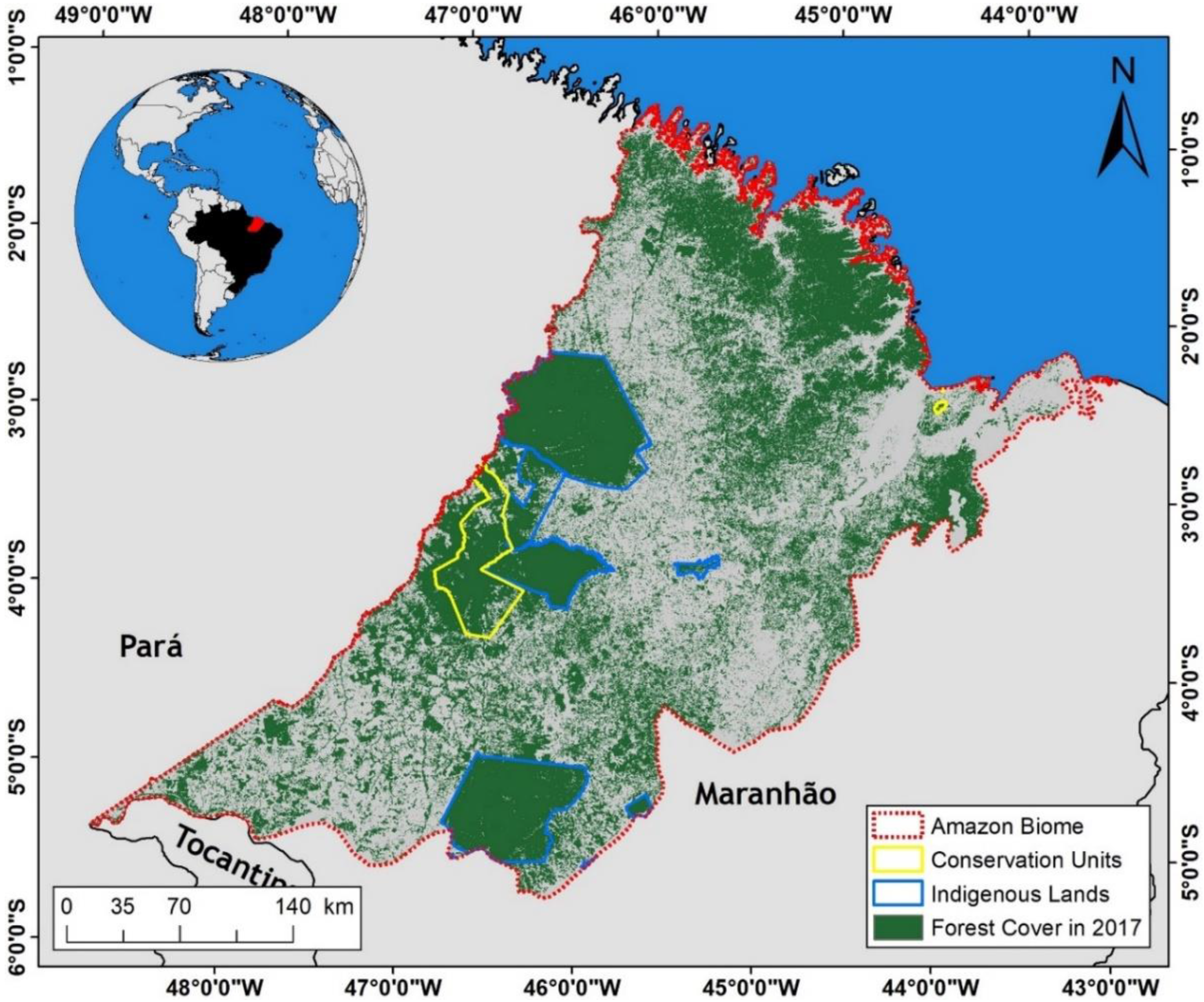
2.1. Study Area

The Maranhão state is located in the northeast region of Brazil, has a territorial area of 329,651.495 km2, and an estimated population in 2021 of 7,153,262 inhabitants [38]. The state straddles the transition between the Amazon and Cerrado biomes [21,22,39], with the Amazon occupying an area of 115,139 km2, or 35% of the state’s territory (Figure 1) [40].
Of the remaining old-growth forest cover (24,700 km2) inside Maranhão’s Amazon region in 2016, around 70% exists in Conservation Units and Indigenous Lands, 10% in agrarian reform settlements, and another 20% scattered on private rural properties [6]. Between 2007 and 2015, degraded forests in the “Mosaico Gurupi” (the region where the most significant proportion of the forest remnants of the Maranhão Amazon region is located) totaled 2200 km2, or the equivalent of 14% of remaining forests in protected areas in the region [8]. The Arariboia Indigenous Land, for example, had 45% of its mature forests degraded in this period [8].

2.2. Dataset

A total of five remote sensing datasets were used in this study, including land use and land cover, active fires, burned areas (fire scars), rainfall, and surface temperature.

2.2.1. Land Use and Land Cover Data

Land use and land cover data were obtained from the MapBiomas Project [41], Collection 3. Annual maps were retrieved for the period between 1985 and 2017. This dataset was obtained by classifying Landsat satellite images with 30-m spatial resolution [42,43], using a theoretical algorithm implemented in a planetary-scale geospatial analysis cloud platform [44]. The data have an overall accuracy of 94.80%, allocation disagreement with 2.80%, and area disagreement with 2.40% [45,46].

2.2.2. Active Fires Data

To understand the forest fire activity in our study area, we used the VNP14IMGTDL_NRT product. As the VNP14IMGTDL_NRT product started in 2012, active fire data from the NASA VIIRS were obtained for the 2012–2017 period. This product is generated from information provided by the VIIRS (Visible Infrared Imaging Radiometer Suite) sensor onboard the NASA/NOAA satellite Suomi National Orbiting Polar Partnership (Suomi NPP) and the JPSS Series satellite NOAA-20 [47,48]. These data have a nominal spatial resolution of 375 m. The VIIRS active fire data provide a more significant response to fires in relatively small areas and improved performance in nighttime detection [47,49]. Consequently, these data are suitable for supporting fire management and scientific applications that require improved detection fidelity [47,49]. In addition, these data are a proxy for the fire activity on the land surface.

2.2.3. Burned Areas Data

To understand the area (extent) impacted by forest fires in our study area, we used the MODIS MCD64A1 product. Monthly burned areas data, or fire scars, were obtained for the 2003–2017 period from the MODIS MCD64A1 product, Collection 6 [50]. The mapping approach of this product employs the contextual analysis of MODIS sensor surface reflectance images in 500 m nominal spatial resolution, plus detections of active fires data with 1 km spatial resolution, also derived from the MODIS sensor [51]. Global and local validations (for the Amazon and Cerrado biomes) showed a suitable performance for this product [52,53,54,55,56].

2.2.4. Rainfall Precipitation Data

Monthly rainfall data for the 2012–2017 period (the same period as active fires data) were obtained from the Climate Hazards Group InfraRed Precipitation with Station data (CHIRPS), with 0.05° of spatial resolution [57]. The CHIRPS rainfall dataset integrates satellite imagery with rain gauge station data to create a time series in a regular pixel grid [57]. In the Brazilian Amazon, validations have shown that the product explains around 73% of the rainfall measured in the field by rain gauges, with a root mean square error below 15 mm month−1 [58].

2.2.5. Land Surface Temperature Data

Monthly surface temperature data were obtained for the 2012–2017 period (the same period as active fires data) using the MODIS MOD11C3 product, Collection 6, available with a spatial resolution of 0.05°. The resulting monthly dataset was derived by compositing and averaging the daily temperature values from the corresponding month of the MODIS MOD11C1 product [59]. The calibration of the product is periodic and performed through data collected in the field, as well as studies of surface radiance [59].

2.3. Data Processing and Analysis

2.3.1. Forest Fragmentation Analysis

We first reclassified the original MapBiomas land use and land cover maps to the binary maps. Then, we consider the class “Forest Formation” (including old- and second-growth forests) as a forest cover in our analyses. Therefore, we assigned the value 1 for forest pixels, and 0 for other land cover pixels.
Then, the binary maps were classified using the Morphological Segmentation of Binary Patterns—MSPA algorithm [60], implemented using GUIDOS, a free software toolbox dedicated to quantitative analysis of digital landscape images (Available online: https://forest.jrc.ec.europa.eu/en/activities/lpa/gtb, accessed on 20 January 2022).
The MSPA is a customized sequence of mathematical morphological operators targeted at describing the geometry and connectivity of the image components [60]. The MSPA’s approach is based on geometric concepts, and can be applied on any scale. The foreground area of a binary image is divided into the following visually distinguished MSPA classes: Edge—the outer perimeter of the forest class (including the Loop, Corridor, and Branch classes); Perforation—edges inside core areas; Core—the forest core area, excluding the edges; and Islets—the forest sections with an area too small to contain a core. More details and illustrations are available in the MSPA Guide (https://forest.jrc.ec.europa.eu/en/activities/lpa/mspa, accessed on 20 January 2022). An example of the MSPA classification is shown in Figure A1.
The edge width of 1020 m (or 34 pixels, due to the spatial resolution of the forest cover data) was used to include the main edge effects, such as canopy desiccation, fire susceptibility, wind turbulence, alteration of the forest structure, and increased tree mortality [19,61].

2.3.2. Spatial Analysis

For the spatial analysis, we used a regular pixel grid with 10 km spatial resolution. Results from the forest fragmentation classification were quantified as the area (square kilometer) for each pixel annually between 1985 and 2017. In addition, we calculated the total number of active fires annually for each regular pixel in the grid, considering the 2012–2017 period.

2.3.3. Statistical Analyses

All statistical analyses were performed using R software [62], including regression and trend analysis. For regression, several models (linear and non-linear) were performed to identify the best model that explains the relationship between the monthly active fires, rainfall, and surface temperature.
For the trend analysis, we used two robust non-parametric methods that are not particularly sensitive to discrepant data, the Mann–Kendall test [63,64] and the Sen’s Slope estimator [65] through the “wq” package in R [66]. The Mann–Kendall test was used to assess whether there is an upward or downward trend over time, while the Sen’s Slope estimator was used to estimate the magnitude of the trends. We adopted a 5% significance level (p ≤ 0.05) for all analyses.

3. Results

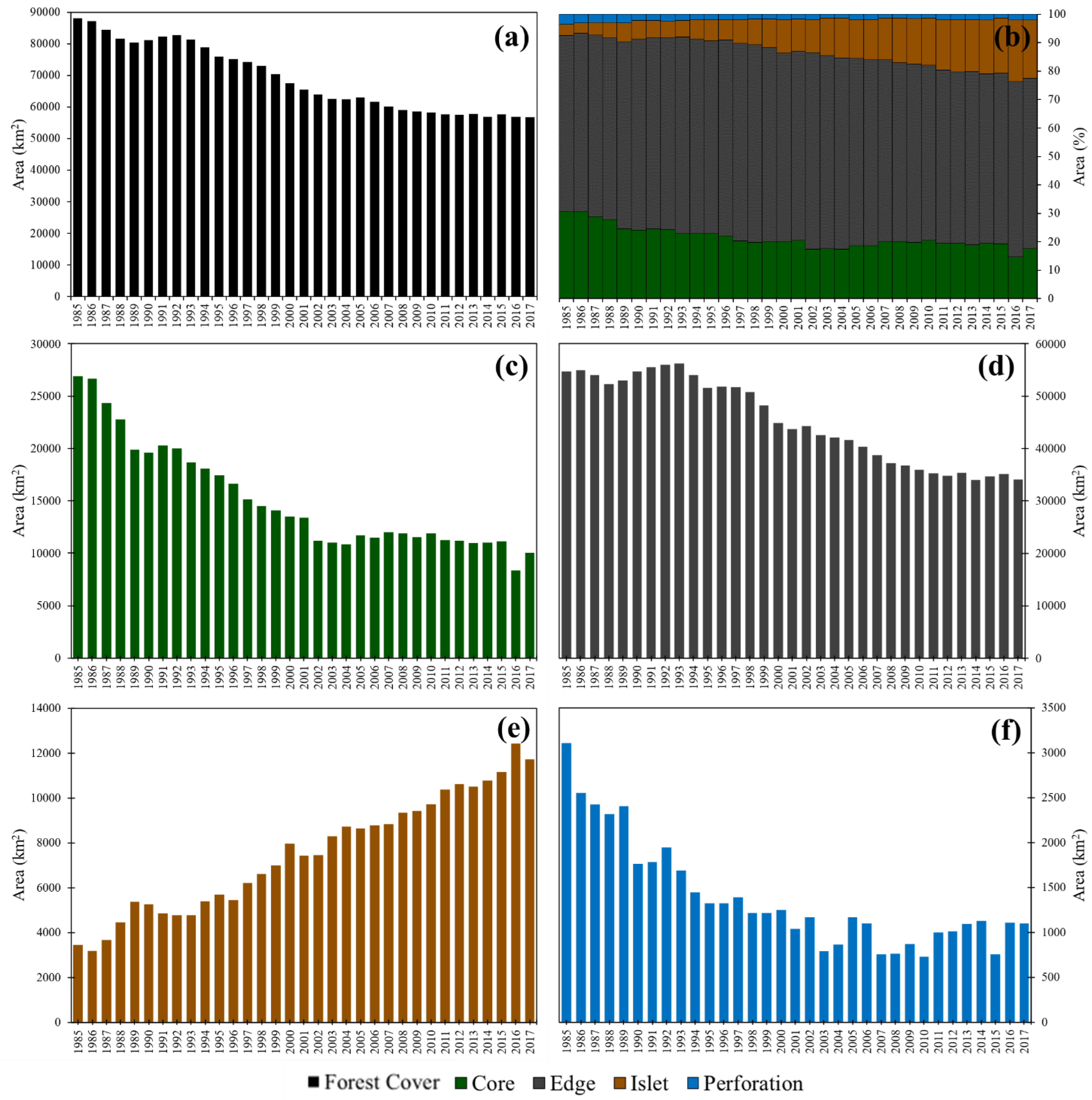
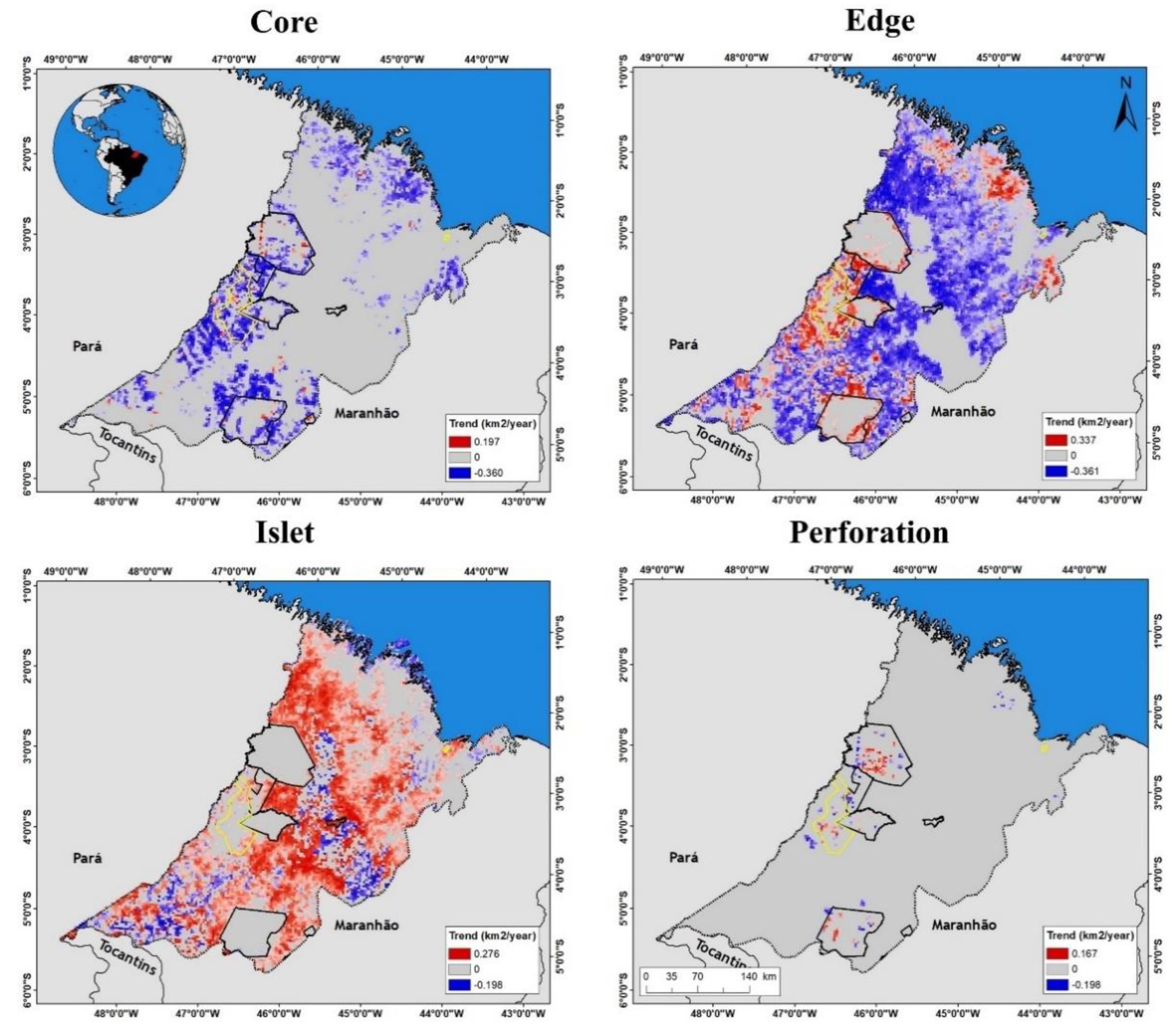
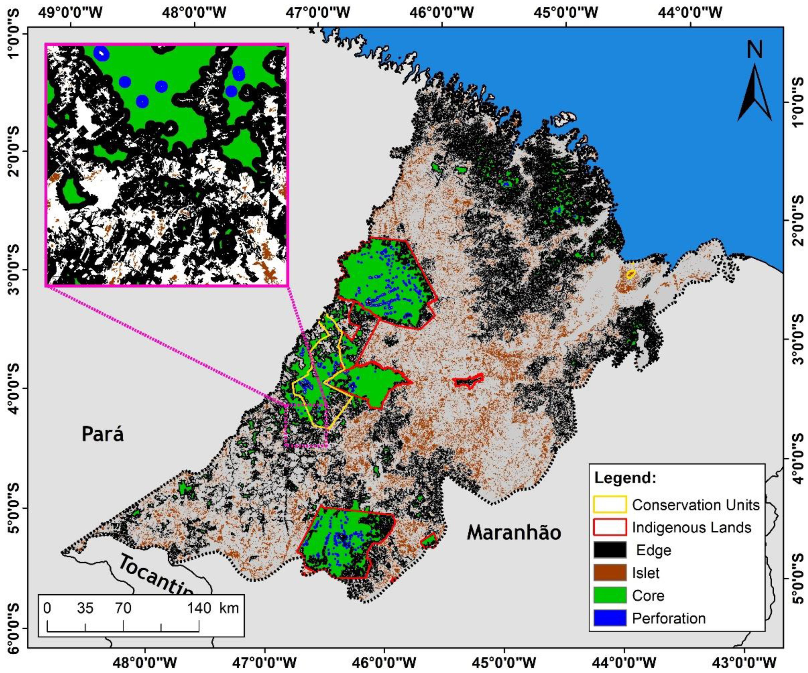
3.1. Forest Fragmentation Dynamics between 1985 and 2017

Forest cover in the study area decreased by 35%, from 88,195 km2 in 1985 to 56,893 km2 in 2017 (Figure 2a), showing a net reduction of 31,302 km2. Although the growth of secondary forests slightly increased total forest cover in 1990–1992, 2005, 2013, and 2015, a trend of significant reduction (p < 0.05) in forest cover was identified for the whole study period (Figure 2a). The reduction was equivalent to an average of 1078 km2 year−1 (Kendall’s tau = −0.936). More than half of the forest cover during this period (1985–2017) corresponded to forest edges (average of 65% ± 3% year−1). Around 21% ± 4% year−1 corresponded to core areas, 12% ± 5% year−1 corresponded to islets, and 2% ± 1% year−1 corresponded to perforations (Figure 2b).
Although ongoing deforestation has induced overall landscape fragmentation of the study area, a close analysis of each fragmentation class reveals different trajectories during the study period (Figure 2c–f). The total area of core forest was reduced from 26,877 km2 in 1985 to 10,029 km2 in 2017 (63% of reduction), with a significant negative trend of 442 km2 year−1 (p < 0.05 and Kendall’s tau = −0.830). The area of the forest edge was reduced from 54,752 km2 in 1985 to 34,047 km2 in 2017 (38% of reduction), with a significant negative trend of 805 km2 year−1 (p < 0.05 and Kendall’s tau = −0.856). The area of perforations was reduced from 3111 km2 in 1985 to 1103 km2 in 2017 (65% of reduction), with a significant negative trend of 48 km2 year−1 (p < 0.05 and Kendall’s tau = −0.689). On the other hand, the area of forest islets increased from 3455 km2 in 1985 to 11,715 km2 in 2017 (239% of increase), with a significant positive trend of 270 km2 year−1 (p < 0.05 and Kendall’s tau = −0.936).
The pixel-by-pixel analysis (Figure 3) yielded general trends similar to those listed above. This spatial configuration also revealed the different temporal trajectories of the four fragmentation classes. Core areas showed significant trends (p < 0.05), with some pixels showing reductions of up to 0.360 km2 year−1 pixel−1, and a few showing increases in the core forest of up to 0.197 km2 year−1 pixel−1. For this fragmentation class, 95% of the trends indicated reductions, and 5% showed increases. Pixels with the largest decreases in the core fragmentation class appeared to be concentrated just outside or at the borders of Conservation Units (CUs) and Indigenous Lands (ILs). The edge fragmentation class also exhibited significant trends (p < 0.05), with around 79% of the areas showing reductions (up to 0.361 km2 year−1 pixel−1), and 21% depicting increases (up to 0.337 km2 year−1 pixel−1). Pixels with increasing trends in the edge class were mainly concentrated in the northern (coastal) region and areas surrounding the CUs and ILs. Pixels showing reduction trends appeared widespread throughout the study area, except within the CUs and ILs. The islet fragmentation class also showed significant trends (p < 0.05), with only around 19% of the areas showing reductions of this fragmentation class (up to 0.198 km2 year−1 pixel−1), and 81% showing increases (up to 0.276 km2 year−1 pixel−1). Pixels showing increasing trends in the islet class were widespread throughout the region, except for the CUs and ILs. Pixels with reduction trends in this class were concentrated in the central and southern portions of the study area. Finally, the perforation fragmentation class also showed significant trends (p < 0.05), with around 54% of the areas showing decreasing trends (up to 0.198 km2 year−1 pixel−1), and 46% showing increasing trends (up to 0.167 km2 year−1 pixel−1). Most pixels with a higher tendency to both increase and decrease were found within CUs and ILs.

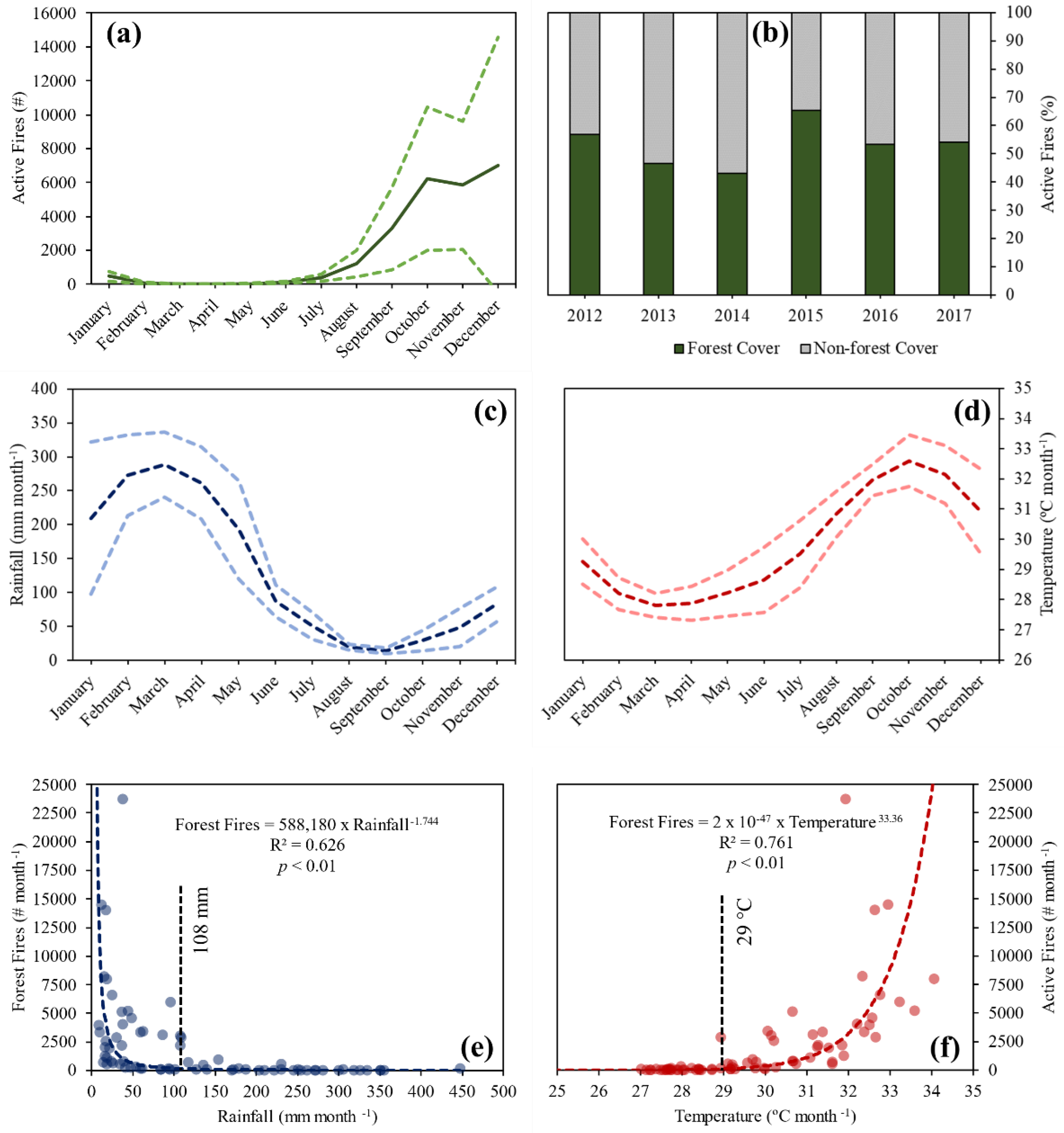
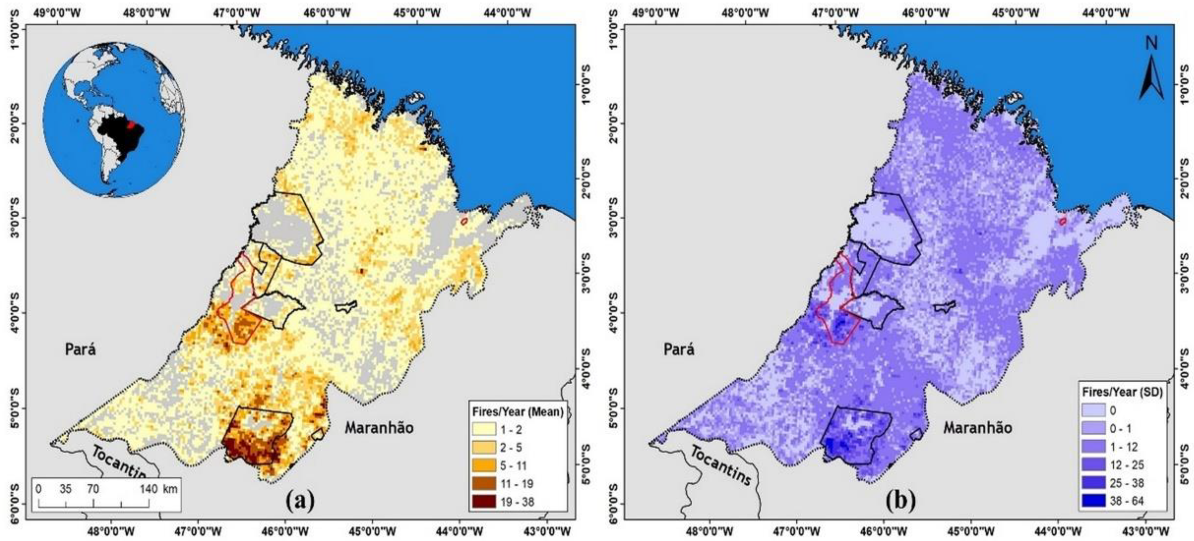
3.2. Active Fire Dynamics between 2012 and 2017

Around 262,205 active fires were recorded in the study area between 2012 and 2017, with an annual average of 43,701 ± 21,763 fires year−1. The forest fires showed a well-defined temporal pattern (Figure 4a), with a lower fire activity between January and July (wet season), and a higher activity between August and December (dry season). The lowest average number of active fires within forest areas was observed in March (8 ± 3 fires month−1), while the maximum number of active fires was observed in December (7024 ± 7533 fires month−1). Fires on forest cover areas accounted for more than half (53 ± 7%) of all active fires registered in the region (Figure 4b) during the studied period, and 2015 was the year with the highest number of registered fires within forest cover areas (65% of the active fires registered that year).
The forest’s susceptibility to fire is associated with the rainfall seasonality (Figure 4c) and temperature (Figure 4d). These two variables combine to produce environmental conditions conducive to fire spread—the lowest fire activity within forest cover areas corresponding to the greater amount of rainfall and lowest temperature levels. However, a three-month delay was observed between the minimum monthly rainfall (15 ± 4 mm in September) and the maximum monthly record of active fires in forests (December); on the other hand, the maximum temperature record (33 ± 0.85 °C in October) preceded by two months the maximum record of forest fires (in December).
Regression analyses, shown in Figure 4e,f, showed that the best-adjusted model was a power function, with a strong and significant (p < 0.01) correlation between total monthly active fires and average rainfall (R2 = 0.626) and temperature (R2 = 0.761). Thus, while active fires progressively decreased with increasing rainfall, active fires increased with increasing average temperature. In addition, 2 thresholds were identified: first, the number of active fires remained below 1000 per month when monthly rainfall amounts stayed above 108 mm. Second, when the air temperature rose above 29°C, the number of active fires increased to monthly accumulated totals of over 1000.
Figure 5 shows the spatial distribution of annual active fires (for the period 2012–2017). The average number of annual active fires in forested land ranged from 1 to 38 active fires per pixel (10 km of spatial resolution), with 60% of the pixels having up to 2 active fires per year, and 2% of the pixels having between 19 and 38 active fires per year (Figure 5a). The pixels with higher hotspot annual averages (19 to 38) were concentrated mainly in the south-central region of the Maranhão Amazon, especially in the surroundings and interior of the IL Araribóia and the CU Gurupi Biological Reserve (Figure 5a). Figure 5b shows the spatial distribution of the standard deviation for the annual average of active fires for the 2012–2017 period.

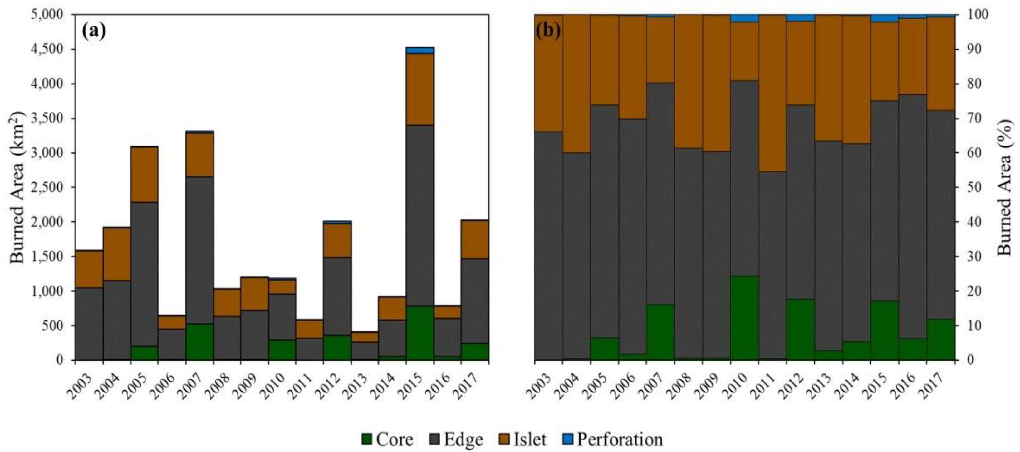
3.3. Forest Fragmentation and Fires between 2003–2017

We used the burned areas to assess the extent of fires on forest cover, and explore its relationship with the forest fragmentation classes. Between 2003 and 2017, a total area of 25,201 km2, or 1680 ± 1132 km2 year−1, was impacted by fire in the region, with a minimum burned area of 407 km2 recorded in 2013, and a maximum of 4526 km2 in 2015; in addition, no significant trend in the burned area (p > 0.05 and Kendall’s tau = −0.086) was observed during the study period (Figure 6).
Areas in the edge fragmentation class experienced the greatest extent of burned areas. An average of around 1031 ± 695 km2 on forest edges burned per year in the region between 2003 and 2017, the equivalent to 61 ± 5% of the total burned forest cover in the study. The second fragmentation class with the greatest extent of forest fires was the islet class, with an annual average of 466 ± 253 km2 year−1 burned between 2003 and 2017, the equivalent to 31 ± 8% of the total burned forests. An average of around 169 ± 227 km2 of the forests core class burned annually during the study period (about 7 ± 8%), while only 13 ± 24 km2 (about 1 ± 1% of the total) of the perforation class burned per year. During the studied period, 2015 was the year with the greatest overall burned forest extent, and the year where each fragmentation class experienced its highest burned area extent (Figure 6a). Results from the trend analysis showed no statistically significant trend (p > 0.05) in burnt areas during the period 2003–2017 (Kendall’s tau: core = 0.276; edges = −0.086; islands = −0.181; and perforation = 0.276).

4. Discussion

Here, we presented the first long-term analysis of the annual extent of forest fragmentation in Maranhão state’s remaining Amazonian forests. This region was exposed to decades of predatory deforestation, which led to a 63% reduction in forest core areas between 1985 and 2017. We also highlighted the remarkable effect of this loss of core forest remnants by an astounding 239% increase in the area of islets (isolated areas of forest too small or too narrow to contain core forests). Vedovato et al. [10] reported that the forest islets in the Maranhão Amazon were 10,877.5 km2 in 2014. However, our estimates for 2017 (11,715 km2) show that the forest fragmentation continues to increase in Maranhão.
Another worrying trend observed in our study was that areas in the perforation class (edges inside core areas) were concentrated in the few legally protected forest remnants, likely due to illegal logging activities [8]. By extending deeply into previously intact forest areas, these fragments expose core forests to detrimental edge effects, including shifts in plant and animal community composition and changes in diversity [67,68], increased rates of tree mortality [69] and fire susceptibility [13,15,18,70], altered microclimates [71], and increased carbon emissions [14,72,73].
The high level of forest fragmentation revealed by our results showed that the secondary forest’s growth did not offset the deforestation induced-fragmentation of old-growth forests in this region. In the Brazilian Amazon, deforestation of secondary forests surpasses old-growth forests, mainly because the secondary forests receive less protection than old-growth forests [74]. In Maranhão specifically, secondary forests have high annual rates of deforestation [9]. They are threatened by recent state land-use legislation [9,75], leading to the large-scale loss of these forests that provide essential ecosystem services [76,77,78]. Evidence in the Amazon has shown that large-scale deforestation has reduced the amount of rainfall [79,80] and affected agricultural production [81].
The recent weakening of deforestation enforcement and dismantling of environmental policies during the last three years in Brazil has led to uptrend deforestation rates in the Brazilian Amazon [82]. In addition to increasing fires directly associated with deforestation [26,29,83], this uptrend induces more forest fragmentation in this region, thereby compromising the achievement of sustainable development goals and international climate agreements.
Our findings indicate a noticeable seasonal pattern of forest fires in the Maranhão Amazon region. The analyses of active fires within forest cover show that forest fires in the Maranhão Amazon occurred mainly during the second half of the year, with a peak in December, which differs from the pattern observed elsewhere in the Brazilian Amazon, where peaks usually occur in August and September [84,85]. However, as Alencar et al. [84] observed for other Amazonian regions, the peak of forest fires in the Maranhão Amazon occurred shortly after the onset of the dry season, at the same time as the temperature increases in the region.
In the Amazon, fires have typically been linked to the deforestation process, resulting from establishing agricultural and pasture areas [29,30]. Fires from cleaning newly deforested areas or from agricultural and pasture areas often accidentally escape to adjacent forests through the edges [13,15,16]. Furthermore, the combination of these ignition sources from human actions [29,30], increased forest edges [13,15,16], and extreme droughts lead to an abnormal increase of forest fires [27,28]. During years of extreme drought, forests become hotter and drier, thus more likely to sustain uncontrolled fires [27,28,30]. In 2015, a drought year for the Brazilian Amazon [27,28], the Maranhão Amazon experienced the largest burned forests extent since 2007. In this region, in addition to the accidental escape of fire into the forests, criminal ignition sources by illegal loggers are common, mainly in protected areas and indigenous lands [6,8,9]. Forest fires also lead to negative socio-economic impacts, such as respiratory illness [31,32,86] in the Amazonian population, as well as economic losses [87].
Here, we showed that the forest fragmentation of the Amazonian forests of Maranhão is an essential factor that determines the occurrence of forest fires in the region. Almost all forest fires in the region between 2003–2017 occurred at the edge and islet fragmentation classes. Due to the alteration of forest remnant configuration in the landscape, forest edges and small forest patches (composed by edges only) have more supportive conditions for the spread of fire, including a drier and hotter microclimate, abundant availability of fuel (necromass due to tree mortality at the edges [72,88]) in the understory, and greater exposure to ignition sources, since they are surrounded by agricultural and livestock areas [13,15,17,18,19,20].
We showed that during extreme drought years, forest core areas (regions less exposed to human activities) were impacted by fires; this occurred because, during extreme drought years, the Amazonian forests becomes drier and hotter, making them more susceptible to spreading fire [27,28]. Our results confirmed that the Amazonian forests of Maranhão have become more fragmented and flammable [84,89]. The increase in the frequency, extent, and intensity of extreme droughts in the region during the 21st century, previously predicted by models [1,90,91], has been observed in the last two decades [27,28,58,92,93,94]. However, the warming of the Pacific and Atlantic surface ocean induced extreme droughts in the Amazon [27,92,93]. This phenomenon is predictable, making it possible to efficiently produce a fire management plan during these years to avoid the spread of wild forests fires [95,96].
Finally, for REDD+ programs [97] in the Maranhão state, decision-makers should not just focus only on deforestation [98], but also on reducing emissions from forest degradation, including forest fires [27,99] and edge effect disturbances [14,73]. In addition, they should increase forest carbon stocks by protecting secondary forest areas that already exist in the state [9,74,76,78,100,101,102].

5. Conclusions

Here, we conclude that predatory exploitation of forest resources in the Maranhão Amazon has resulted in highly fragmented and fire-prone forests remnants. Thus, it is urgent to protect Maranhão forests from illegal deforestation and degradation (from edge effects and fires disturbances). Therefore, environmental and land policies elaborating with cooperation between the Maranhão state, civil society, the private sector, and scientists is necessary and urgent to protect old-growth and secondary forests in the region. On the other hand, in the context of the United Nations Decade on Ecosystem Restoration, this threatened area of the Brazilian Amazon is recognized as a forest restoration hotspot, and the protection of secondary forests is urgently needed to offset, in part, the historical forest fragmentation in the region.
Our work shows the already known diversity of fire types in the eastern region of the Brazilian Amazon. Furthermore, our findings reveal that forest fires depend not only on the climate, but also on the synergic interaction between the configuration of forest remnants and the availability of man-made ignition sources in the landscape. However, during extreme drought years, fire control measures are necessary to prevent the spread of uncontrolled forest fires.
Finally, our findings contribute to filling gaps in the understanding of forest fragmentation and its relationship with forest fires in the Amazon region of the state of Maranhão. Furthermore, future research should analyze the period after 2017 to understand forest fragmentation and fires during the recent increasing deforestation rates in the Brazilian Amazon.

Author Contributions

Data curation, C.H.L.S.-J.; Formal analysis, C.H.L.S.-J.; Methodology, C.H.L.S.-J.; Writing—original draft, C.H.L.S.-J., A.T.M.B. and D.S.B.; Writing—review and editing, O.S.C.J., A.L.S., L.O.D.B., A.L.S.S., S.T.A., C.T.A., A.T.G.F., G.X.R., D.C., F.B.S., M.S.S.P., S.A., M.K., L.B.V., L.O.A. and L.E.O.C.A. All authors have read and agreed to the published version of the manuscript.

Funding

This research was funded by Fundação de Amparo à Pesquisa e ao Desenvolvimento Científico e Tecnológico do Maranhão—FAPEMA, grant number 00813/19 and 02989/20. This study was financed in part by the Coordenação de Aperfeiçoamento de Pessoal de Nível Superior—Brasil (CAPES)—Finance Code 001. The University of Manchester funded this work through the project entitled “Forest fragmentation mapping of Amazon and its vulnerable margin Amazon-Cerrado transition forests”. Part of this work was carried out at the Jet Propulsion Laboratory, California Institute of Technology, under a contract with the National Aeronautics and Space Administration (NASA). C. T. A was funded by Fundação de Amparo à Pesquisa do Estado de São Paulo (FAPESP) [grant number 2020/06734-0]. L.B.V thanks Coordenação de Aperfeiçoamento de Pessoal de Nível Superior—Brasil (CAPES) (number 88881.128127/2016-01). S.T.A. is currently receiving postdoctoral support from Programa de Fixação de Doutor from the Universidade Estadual de Maranhão (UEMA). L.O.A acknowledges MAP-FIRE (IAI—SGP-HW016), National Council for Scientific and Technological Development—CNPq (314473/2020-3 and 409531/2021-9), and São Paulo Research Foundation—(FAPESP 2016/02018-2 and 2020/16457-3). L.E.O.C.A. acknowledges São Paulo Research Foundation—(FAPESP-SHELL 2020/15230-5), CNPq (314416/2020-0) and Brazilian Space Agency (AEB) for the support.

Institutional Review Board Statement

Not applicable.

Informed Consent Statement

Not applicable.

Data Availability Statement

The data that support the findings of this study are all publicly available from their sources. Processed data, products, and code produced in this study are available from the corresponding author upon reasonable request.

Conflicts of Interest

The authors declare no conflict of interest. The funders had no role in the design of the study; in the collection, analyses, or interpretation of data; in the writing of the manuscript, or in the decision to publish the results.

Appendix A

Figure A1. The result of the MSPA (Morphological Spatial Pattern Analysis) algorithm’s classification using the 2017 forest map (see Figure 1).
Fire 05 00077 g0a1

References

  1. Malhi, Y.; Roberts, J.T.; Betts, R.A.; Killeen, T.J.; Li, W.; Nobre, C.A. Climate Change, Deforestation, and the Fate of the Amazon. Science 2008, 319, 169–172. [Google Scholar] [CrossRef] [Green Version]
  2. Baccini, A.; Goetz, S.J.; Walker, W.S.; Laporte, N.T.; Sun, M.; Sulla-Menashe, D.; Hackler, J.; Beck, P.S.a.; Dubayah, R.; Friedl, M.A.; et al. Estimated Carbon Dioxide Emissions from Tropical Deforestation Improved by Carbon-Density Maps. Nat. Clim. Chang. 2012, 2, 182–185. [Google Scholar] [CrossRef]
  3. Saatchi, S.S.; Harris, N.L.; Brown, S.; Lefsky, M.; Mitchard, E.T.; Salas, W.; Zutta, B.R.; Buermann, W.; Lewis, S.L.; Hagen, S.; et al. Benchmark Map of Forest Carbon Stocks in Tropical Regions across Three Continents. Proc. Natl. Acad. Sci. USA 2011, 108, 9899–9904. [Google Scholar] [CrossRef] [PubMed] [Green Version]
  4. Aragão, L.E.O.C. Environmental Science: The Rainforest’s Water Pump. Nature 2012, 489, 217–218. [Google Scholar] [CrossRef]
  5. RAISG-Amazonian Network of Georeferenced Socio-Environmental Information Deforestation in the Amazonia (1970–2013). Available online: https://www.amazoniasocioambiental.org/en/download/deforestation-in-the-amazonia-1970-2013-atlas/ (accessed on 1 January 2019).
  6. Celentano, D.; Rousseau, G.X.; Muniz, F.H.; van Deursen Varga, I.; Martinez, C.; Carneiro, M.S.; Miranda, M.V.C.; Barros, M.N.R.; Freitas, L.; da Silva Narvaes, I.; et al. Towards Zero Deforestation and Forest Restoration in the Amazon Region of Maranhão State, Brazil. Land Use Policy 2017, 68, 692–698. [Google Scholar] [CrossRef]
  7. Almeida, A.S.; Vieira, I.C. Centro de Endemismo Belém: Status Da Vegetação Remanescente e Desafios Para a Conservação Da Biodiversidade e Restauração Ecológica. Rev. Estud. Univ. 2010, 36, 95–111. [Google Scholar]
  8. Celentano, D.; Miranda, M.V.C.; Rousseau, G.X.; Muniz, F.H.; Do Carmo Loch, V.; van Deursen Varga, I.; Freitas, L.; Araújo, P.; da Silva Narvaes, P.A.I.; Adami, M.; et al. Desmatamento, Degradação e Violência No “Mosaico Gurupi”—A Região Mais Ameaçada Da Amazônia. Estud. Avançados 2018, 32, 315–339. [Google Scholar] [CrossRef]
  9. Silva-Junior, C.H.L.; Celentano, D.; Rousseau, G.X.; de Moura, E.G.; van Deursen Varga, I.; Martinez, C.; Martins, M.B. Amazon Forest on the Edge of Collapse in the Maranhão State, Brazil. Land Use Policy 2020, 97, 104806. [Google Scholar] [CrossRef]
  10. Vedovato, L.B.; Fonseca, M.G.; Arai, E.; Anderson, L.O.; Aragão, L.E.O.C. The Extent of 2014 Forest Fragmentation in the Brazilian Amazon. Reg. Environ. Change 2016, 16, 2485–2490. [Google Scholar] [CrossRef]
  11. Villard, M.-A.; Metzger, J.P. Beyond the Fragmentation Debate: A Conceptual Model to Predict When Habitat Configuration Really Matters. J. Appl. Ecol. 2014, 51, 309–318. [Google Scholar] [CrossRef]
  12. Fahrig, L. Effects of Habitat Fragmentation on Biodiversity. Annu. Rev. Ecol. Evol. Syst. 2003, 34, 487–515. [Google Scholar] [CrossRef] [Green Version]
  13. Silva-Junior, C.; Aragão, L.; Fonseca, M.; Almeida, C.; Vedovato, L.; Anderson, L. Deforestation-Induced Fragmentation Increases Forest Fire Occurrence in Central Brazilian Amazonia. Forests 2018, 9, 305. [Google Scholar] [CrossRef] [Green Version]
  14. Silva-Junior, C.H.L.; Aragão, L.E.O.C.; Anderson, L.O.; Fonseca, M.G.; Shimabukuro, Y.E.; Vancutsem, C.; Achard, F.; Beuchle, R.; Numata, I.; Silva, C.A.; et al. Persistent Collapse of Biomass in Amazonian Forest Edges Following Deforestation Leads to Unaccounted Carbon Losses. Sci. Adv. 2020, 6, eaaz8360. [Google Scholar] [CrossRef] [PubMed]
  15. Armenteras, D.; González, T.M.; Retana, J. Forest Fragmentation and Edge Influence on Fire Occurrence and Intensity under Different Management Types in Amazon Forests. Biol. Conserv. 2013, 159, 73–79. [Google Scholar] [CrossRef]
  16. Cano-Crespo, A.; Oliveira, P.J.C.; Boit, A.; Cardoso, M.; Thonicke, K. Forest Edge Burning in the Brazilian Amazon Promoted by Escaping Fires from Managed Pastures. J. Geophys. Res. Biogeosciences 2015, 120, 2095–2107. [Google Scholar] [CrossRef] [Green Version]
  17. Laurance, W.F.; Williamson, G.B. Positive Feedbacks among Forest Fragmentation, Drought, and Climate Change in the Amazon. Conserv. Biol. 2001, 15, 1529–1535. [Google Scholar] [CrossRef] [Green Version]
  18. Driscoll, D.A.; Armenteras, D.; Bennett, A.F.; Brotons, L.; Clarke, M.F.; Doherty, T.S.; Haslem, A.; Kelly, L.T.; Sato, C.F.; Sitters, H.; et al. How Fire Interacts with Habitat Loss and Fragmentation. Biol. Rev. 2021, 96, 976–998. [Google Scholar] [CrossRef] [PubMed]
  19. Broadbent, E.N.; Asner, G.P.; Oliveira, P.J.C.; Knapp, D.E.; Keller, M.; Silva, J.N. Forest Fragmentation and Edge Effects from Deforestation and Selective Logging in the Brazilian Amazon. Biol. Conserv. 2008, 141, 1745–1757. [Google Scholar] [CrossRef]
  20. Numata, I.; Khand, K.; Kjaersgaard, J.; Cochrane, M.A.; Silva, S.S. Forest Evapotranspiration Dynamics over a Fragmented Forest Landscape under Drought in Southwestern Amazonia. Agric. For. Meteorol. 2021, 306, 108446. [Google Scholar] [CrossRef]
  21. Silva-Junior, C.H.L.; Freire, A.T.G.; Anderson, L.O.; Silva, F.B.; Mendes, J.J.; de Aragão, L.E.O.C. A Zona de Transição Entre a Amazônia e o Cerrado No Estado Do Maranhão. Parte II: Caracterização Preliminar Dos Dados de Área Queimada (Produto MODIS MCD45A1). In Proceedings of the XVII Simpósio Brasileiro de SensoriamentoSimpósio Brasileiro de Sensoriamento, João Pessoa, Brasil, 25–29 April 2015; INPE: João Pessoa, Brasil, 2015; pp. 7478–7485. [Google Scholar]
  22. Freire, A.T.G.; Junior, C.H.L.S.; Anderson, L.O.; Oliveira, L.E.; de Aragão, C.; Silva, F.B.; Mendes, J.J. A Zona de Transição Entre a Amazônia e o Cerrado No Estado Do Maranhão. Parte I: Caracterização Preliminar Dos Dados Focos de Queimadas (Produto MODIS MCD14ML). In Proceedings of the XVII Simpósio Brasileiro de SensoriamentoSimpósio Brasileiro de Sensoriamento, João Pessoa, Brasil, 25–29 April 2015; Silva, F.B., Ed.; INPE: João Pessoa, Brasil, 2015; pp. 7471–7477. [Google Scholar]
  23. Silva-Junior, C.H.L.; Anderson, L.O.; de Aragão, L.E.O.C.; Rodrigues, B.D. Dinâmica Das Queimadas No Cerrado Do Estado Do Maranhão, Nordeste Do Brasil. Geogr. Dep. Univ. Sao Paulo 2018, 35, 1–14. [Google Scholar] [CrossRef] [Green Version]
  24. Mataveli, G.A.V.; Silva, M.E.S.; Pereira, G.; da Silva Cardozo, F.; Kawakubo, F.S.; Bertani, G.; Costa, J.C.; de Cássia Ramos, R.; da Silva, V.V. Satellite Observations for Describing Fire Patterns and Climate-Related Fire Drivers in the Brazilian Savannas. Nat. Hazards Earth Syst. Sci. 2018, 18, 125–144. [Google Scholar] [CrossRef] [Green Version]
  25. da Silva Bezerra Bezerra, D.; Dias, B.C.C.; Rodrigues, L.H.D.S.; Tomaz, R.B.; dos Santos, A.L.S.; Junior, C.H.L.S. Análise Dos Focos de Calor e Seus Impactos No Maranhão Durante Eventos de Seca No Período 1998 a 2016. Rev. Bras. Climatol. 2018, 22, 446–462. [Google Scholar] [CrossRef] [Green Version]
  26. Silveira, M.V.F.; Petri, C.A.; Broggio, I.S.; Chagas, G.O.; Macul, M.S.; Leite, C.C.S.S.; Ferrari, E.M.M.; Amim, C.G.V.; Freitas, A.L.R.; Motta, A.Z.V.; et al. Drivers of Fire Anomalies in the Brazilian Amazon: Lessons Learned from the 2019 Fire Crisis. Land 2020, 9, 516. [Google Scholar] [CrossRef]
  27. Aragão, L.E.O.C.; Anderson, L.O.; Fonseca, M.G.; Rosan, T.M.; Vedovato, L.B.; Wagner, F.H.; Silva, C.V.J.; Silva Junior, C.H.L.; Arai, E.; Aguiar, A.P.; et al. 21st Century Drought-Related Fires Counteract the Decline of Amazon Deforestation Carbon Emissions. Nat. Commun. 2018, 9, 536. [Google Scholar] [CrossRef] [PubMed]
  28. Silva-Junior, C.H.L.; Anderson, L.O.; Silva, A.L.; Almeida, C.T.; Dalagnol, R.; Pletsch, M.A.J.S.; Penha, T.V.; Paloschi, R.A.; Aragão, L.E.O.C. Fire Responses to the 2010 and 2015/2016 Amazonian Droughts. Front. Earth Sci. 2019, 7, 1–16. [Google Scholar] [CrossRef]
  29. Barlow, J.; Berenguer, E.; Carmenta, R.; França, F. Clarifying Amazonia’s Burning Crisis. Glob. Change Biol. 2020, 26, 319–321. [Google Scholar] [CrossRef] [Green Version]
  30. Berenguer, E.; Carvalho, N.; Anderson, L.O.; Aragão, L.E.O.C.; França, F.; Barlow, J. Improving the Spatial-temporal Analysis of Amazonian Fires. Glob. Change Biol. 2021, 27, 469–471. [Google Scholar] [CrossRef]
  31. Campanharo, W.A.; Morello, T.; Christofoletti, M.A.M.; Anderson, L.O. Hospitalization Due to Fire-Induced Pollution in the Brazilian Legal Amazon from 2005 to 2018. Remote Sens. 2021, 14, 69. [Google Scholar] [CrossRef]
  32. Smith, L.T.; Aragão, L.E.O.C.; Sabel, C.E.; Nakaya, T. Drought Impacts on Children’s Respiratory Health in the Brazilian Amazon. Sci. Rep. 2014, 4, 3726. [Google Scholar] [CrossRef] [Green Version]
  33. Barlow, J.; Lennox, G.D.; Ferreira, J.; Berenguer, E.; Lees, A.C.; Nally, R.M.; Thomson, J.R.; de Barros Ferraz, S.F.; Louzada, J.; Oliveira, V.H.F.; et al. Anthropogenic Disturbance in Tropical Forests Can Double Biodiversity Loss from Deforestation. Nature 2016, 535, 144–147. [Google Scholar] [CrossRef] [Green Version]
  34. Silva, C.V.J.; Aragão, L.E.O.C.; Barlow, J.; Espirito-Santo, F.; Young, P.J.; Anderson, L.O.; Berenguer, E.; Brasil, I.; Foster Brown, I.; Castro, B.; et al. Drought-Induced Amazonian Wildfires Instigate a Decadal-Scale Disruption of Forest Carbon Dynamics. Philos. Trans. R. Soc. B Biol. Sci. 2018, 373, 20180043. [Google Scholar] [CrossRef] [PubMed] [Green Version]
  35. Pontes-Lopes, A.; Silva, C.V.J.; Barlow, J.; Rincón, L.M.; Campanharo, W.A.; Nunes, C.A.; de Almeida, C.T.; Silva Júnior, C.H.L.; Cassol, H.L.G.; Dalagnol, R.; et al. Drought-Driven Wildfire Impacts on Structure and Dynamics in a Wet Central Amazonian Forest. Proc. R. Soc. B Biol. Sci. 2021, 288, 20210094. [Google Scholar] [CrossRef] [PubMed]
  36. Silva, C.V.J.; Aragão, L.E.O.C.; Young, P.J.; Espirito-Santo, F.; Berenguer, E.; Anderson, L.O.; Brasil, I.; Pontes-Lopes, A.; Ferreira, J.; Withey, K.; et al. Estimating the Multi-Decadal Carbon Deficit of Burned Amazonian Forests. Environ. Res. Lett. 2020, 15, 114023. [Google Scholar] [CrossRef]
  37. Fearnside, P.M. Amazon Forest Maintenance as a Source of Environmental Services. An. Acad. Bras. Ciências 2008, 80, 101–114. [Google Scholar] [CrossRef] [Green Version]
  38. IBGE-Instituto Brasileiro de Geografia e Estatística Cidades e Estados: Maranhão. Available online: https://www.ibge.gov.br/cidades-e-estados/ma/.html (accessed on 1 January 2021).
  39. Silva, F.B.; Santos, J.R.N.; Feitosa, F.E.C.S.; Silva, I.D.C.; de Araújo, M.L.S.; Guterres, C.E.; dos Santos, J.S.; Ribeiro, C.V.; da Silva Bezerra, D.; Neres, R.L. Evidências de Mudanças Climáticas Na Região de Transição Amazônia-Cerrado No Estado Do Maranhão. Rev. Bras. Meteorol. 2016, 31, 330–336. [Google Scholar] [CrossRef]
  40. MMA–Ministério do Meio Ambiente Amazônia. Available online: http://www.mma.gov.br/biomas/amazônia (accessed on 1 January 2018).
  41. Souza, C.M.; Shimbo, J.Z.; Rosa, M.R.; Parente, L.L.; Alencar, A.A.; Rudorff, B.F.T.; Hasenack, H.; Matsumoto, M.; Ferreira, L.G.; Souza-Filho, P.W.M.; et al. Reconstructing Three Decades of Land Use and Land Cover Changes in Brazilian Biomes with Landsat Archive and Earth Engine. Remote Sens. 2020, 12, 2735. [Google Scholar] [CrossRef]
  42. Wulder, M.A.; Masek, J.G.; Cohen, W.B.; Loveland, T.R.; Woodcock, C.E. Opening the Archive: How Free Data Has Enabled the Science and Monitoring Promise of Landsat. Remote Sens. Environ. 2012, 122, 2–10. [Google Scholar] [CrossRef]
  43. Wulder, M.A.; Loveland, T.R.; Roy, D.P.; Crawford, C.J.; Masek, J.G.; Woodcock, C.E.; Allen, R.G.; Anderson, M.C.; Belward, A.S.; Cohen, W.B.; et al. Current Status of Landsat Program, Science, and Applications. Remote Sens. Environ. 2019, 225, 127–147. [Google Scholar] [CrossRef]
  44. Gorelick, N.; Hancher, M.; Dixon, M.; Ilyushchenko, S.; Thau, D.; Moore, R. Google Earth Engine: Planetary-Scale Geospatial Analysis for Everyone. Remote Sens. Environ. 2017, 202, 18–27. [Google Scholar] [CrossRef]
  45. MapBiomas Accuracy Analysis. Available online: http://mapbiomas.org/en/accuracy-analysis (accessed on 1 January 2020).
  46. Pontius, R.G.; Millones, M. Death to Kappa: Birth of Quantity Disagreement and Allocation Disagreement for Accuracy Assessment. Int. J. Remote Sens. 2011, 32, 4407–4429. [Google Scholar] [CrossRef]
  47. Schroeder, W.; Oliva, P.; Giglio, L.; Csiszar, I.A. The New VIIRS 375m Active Fire Detection Data Product: Algorithm Description and Initial Assessment. Remote Sens. Environ. 2014, 143, 85–96. [Google Scholar] [CrossRef]
  48. Csiszar, I.; Schroeder, W.; Giglio, L.; Ellicott, E.; Vadrevu, K.P.; Justice, C.O.; Wind, B. Active Fires from the Suomi NPP Visible Infrared Imaging Radiometer Suite: Product Status and First Evaluation Results. J. Geophys. Res. Atmos. 2014, 119, 803–816. [Google Scholar] [CrossRef]
  49. National Aeronautics and Space Administration (NASA) VIIRS I-Band 375 m Active Fire Data. Available online: https://earthdata.nasa.gov/earth-observation-data/near-real-time/firms/viirs-i-band-active-fire-data (accessed on 1 January 2020).
  50. Giglio, L. MCD64A1 V006: MODIS/Terra+Aqua Burned Area Monthly L3 Global 500 m SIN Grid. Available online: https://lpdaac.usgs.gov/products/mcd64a1v006/ (accessed on 1 January 2020).
  51. Giglio, L.; Boschetti, L.; Roy, D.P.; Humber, M.L.; Justice, C.O. The Collection 6 MODIS Burned Area Mapping Algorithm and Product. Remote Sens. Environ. 2018, 217, 72–85. [Google Scholar] [CrossRef] [PubMed]
  52. Shimabukuro, Y.E.; Miettinen, J.; Beuchle, R.; Grecchi, R.C.; Simonetti, D.; Achard, F. Estimating Burned Area in Mato Grosso, Brazil, Using an Object-Based Classification Method on a Systematic Sample of Medium Resolution Satellite Images. IEEE J. Sel. Top. Appl. Earth Obs. Remote Sens. 2015, 8, 4502–4508. [Google Scholar] [CrossRef]
  53. Alves, D.B.; Pérez-Cabello, F.; Rodrigues Mimbrero, M.; Febrer-Martínez, M. Accuracy Assessment of the Latest Generations of MODIS Burned Area Products for Mapping Fire Scars on a Regional Scale over Campos Amazônicos Savanna Enclave (Brazilian Amazon). J. Appl. Remote Sens. 2018, 12, 026026. [Google Scholar] [CrossRef]
  54. Rodrigues, J.A.; Libonati, R.; Pereira, A.A.; Nogueira, J.M.P.; Santos, F.L.M.; Peres, L.F.; Santa Rosa, A.; Schroeder, W.; Pereira, J.M.C.; Giglio, L.; et al. How Well Do Global Burned Area Products Represent Fire Patterns in the Brazilian Savannas Biome? An Accuracy Assessment of the MCD64 Collections. Int. J. Appl. Earth Obs. Geoinf. 2019, 78, 318–331. [Google Scholar] [CrossRef]
  55. Pessôa, A.C.M.; Anderson, L.O.; Carvalho, N.S.; Campanharo, W.A.; Junior, C.H.L.S.; Rosan, T.M.; Reis, J.B.C.; Pereira, F.R.S.; Assis, M.; Jacon, A.D.; et al. Intercomparison of Burned Area Products and Its Implication for Carbon Emission Estimations in the Amazon. Remote Sens. 2020, 12, 3864. [Google Scholar] [CrossRef]
  56. Boschetti, L.; Roy, D.P.; Giglio, L.; Huang, H.; Zubkova, M.; Humber, M.L. Global Validation of the Collection 6 MODIS Burned Area Product. Remote Sens. Environ. 2019, 235, 111490. [Google Scholar] [CrossRef] [PubMed]
  57. Funk, C.; Peterson, P.; Landsfeld, M.; Pedreros, D.; Verdin, J.; Shukla, S.; Husak, G.; Rowland, J.; Harrison, L.; Hoell, A.; et al. The Climate Hazards Infrared Precipitation with Stations—A New Environmental Record for Monitoring Extremes. Sci. Data 2015, 2, 150066. [Google Scholar] [CrossRef] [Green Version]
  58. Anderson, L.O.; Ribeiro Neto, G.; Cunha, A.P.; Fonseca, M.G.; de Moura, Y.M.; Dalagnol, R.; Wagner, F.H.; de Aragão, L.E.O.E.C. Vulnerability of Amazonian Forests to Repeated Droughts. Philos. Trans. R. Soc. B Biol. Sci. 2018, 373, 20170411. [Google Scholar] [CrossRef] [PubMed]
  59. Wan, Z.; Hook, S.; Hulley, G. MOD11C3 MODIS/Terra Land Surface Temperature/Emissivity Monthly L3 Global 0.05Deg CMG V006. Available online: https://doi.org/10.5067/MODIS/MOD11C3.006 (accessed on 21 November 2016).
  60. Soille, P.; Vogt, P. Morphological Segmentation of Binary Patterns. Pattern Recognit. Lett. 2009, 30, 456–459. [Google Scholar] [CrossRef]
  61. Laurance, W.F.; Camargo, J.L.C.; Fearnside, P.M.; Lovejoy, T.E.; Williamson, G.B.; Mesquita, R.C.G.; Meyer, C.F.J.; Bobrowiec, P.E.D.; Laurance, S.G.W. An Amazonian Rainforest and Its Fragments as a Laboratory of Global Change. Biol. Rev. 2018, 93, 223–247. [Google Scholar] [CrossRef]
  62. R Core Team R: A Language and Environment for Statistical Computing. R Foundation for Statistical Computing, Vienna, Austria. Available online: https://www.r-project.org (accessed on 22 June 2020).
  63. Kendall, M.G. Rank Correlation Methods; Charles Griffin: London, UK, 1975. [Google Scholar]
  64. Mann, H.B. Nonparametric Tests Against Trend. Econometrica 1945, 13, 245. [Google Scholar] [CrossRef]
  65. Sen, P.K. Estimates of the Regression Coefficient Based on Kendall’s Tau. J. Am. Stat. Assoc. 1968, 63, 1379. [Google Scholar] [CrossRef]
  66. Jassby, A.D.; Cloern, J.E. Package ‘Wq’. Available online: https://cran.r-project.org/web/packages/wq/wq.pdf (accessed on 19 May 2016).
  67. Benítez-Malvido, J.; Martínez-Ramos, M. Impact of Forest Fragmentation on Understory Plant Species Richness in Amazonia. Conserv. Biol. 2003, 17, 389–400. [Google Scholar] [CrossRef] [Green Version]
  68. Cagnolo, L.; Cabido, M.; Valladares, G. Plant Species Richness in the Chaco Serrano Woodland from Central Argentina: Ecological Traits and Habitat Fragmentation Effects. Biol. Conserv. 2006, 132, 510–519. [Google Scholar] [CrossRef]
  69. Nascimento, H.E.M.; Laurance, W.F. Biomass Dynamics in Amazonian Forest Fragments. Ecol. Appl. 2004, 14, 127–138. [Google Scholar] [CrossRef] [Green Version]
  70. Cochrane, M.A.; Laurance, W.F. Fire as a Large-Scale Edge Effect in Amazonian Forests. J. Trop. Ecol. 2002, 18, 311–325. [Google Scholar] [CrossRef] [Green Version]
  71. Williams-Linera, G.; Domínguez-Gastelú, V.; García-Zurita, M.E. Microenvironment and Floristics of Different Edges in a Fragmented Tropical Rainforest. Conserv. Biol. 1998, 12, 1091–1102. [Google Scholar] [CrossRef]
  72. Laurance, W.F.; Laurance, S.G.; Ferreira, L.V.; Rankin-de-Merona, J.M.; Gascon, C.; Lovejoy, T.E. Biomass Collapse in Amazonian Forest Fragments. Science 1997, 278, 1117–1118. [Google Scholar] [CrossRef]
  73. Numata, I.; Cochrane, M.A.; Souza Jr, C.M.; Sales, M.H. Carbon Emissions from Deforestation and Forest Fragmentation in the Brazilian Amazon. Environ. Res. Lett. 2011, 6, 044003. [Google Scholar] [CrossRef]
  74. Nunes, S.; Oliveira, L.; Siqueira, J.; Morton, D.C.; Souza, C.M. Unmasking Secondary Vegetation Dynamics in the Brazilian Amazon. Environ. Res. Lett. 2020, 15, 034057. [Google Scholar] [CrossRef]
  75. Silva-Junior, C.H.L.; Alvarado, S.T.; Celentano, D.; Rousseau, G.X.; Hernández, L.M.; Ferraz, T.M.; Silva, F.B.; de Melo, M.H.F.; Rodrigues, T.C.S.; Viegas, J.C.; et al. Northeast Brazil’s Imperiled Cerrado. Science 2021, 372, 139–140. [Google Scholar] [CrossRef]
  76. Poorter, L.; Bongers, F.; Aide, T.M.; Almeyda Zambrano, A.M.; Balvanera, P.; Becknell, J.M.; Boukili, V.; Brancalion, P.H.S.; Broadbent, E.N.; Chazdon, R.L.; et al. Biomass Resilience of Neotropical Secondary Forests. Nature 2016, 530, 211–214. [Google Scholar] [CrossRef]
  77. Lennox, G.D.; Gardner, T.A.; Thomson, J.R.; Ferreira, J.; Berenguer, E.; Lees, A.C.; Mac Nally, R.; Aragão, L.E.O.C.; Ferraz, S.F.B.; Louzada, J.; et al. Second Rate or a Second Chance? Assessing Biomass and Biodiversity Recovery in Regenerating Amazonian Forests. Glob. Chang. Biol. 2018, 24, 5680–5694. [Google Scholar] [CrossRef] [Green Version]
  78. Heinrich, V.H.A.; Dalagnol, R.; Cassol, H.L.G.; Rosan, T.M.; de Almeida, C.T.; Silva Junior, C.H.L.; Campanharo, W.A.; House, J.I.; Sitch, S.; Hales, T.C.; et al. Large Carbon Sink Potential of Secondary Forests in the Brazilian Amazon to Mitigate Climate Change. Nat. Commun. 2021, 12, 1785. [Google Scholar] [CrossRef] [PubMed]
  79. Leite-Filho, A.T.; Soares-Filho, B.S.; Davis, J.L.; Abrahão, G.M.; Börner, J. Deforestation Reduces Rainfall and Agricultural Revenues in the Brazilian Amazon. Nat. Commun. 2021, 12, 2591. [Google Scholar] [CrossRef] [PubMed]
  80. Silva-Junior, C.; Almeida, C.; Santos, J.; Anderson, L.; Aragão, L.; Silva, F. Spatiotemporal Rainfall Trends in the Brazilian Legal Amazon between the Years 1998 and 2015. Water 2018, 10, 1220. [Google Scholar] [CrossRef] [Green Version]
  81. Rattis, L.; Brando, P.M.; Macedo, M.N.; Spera, S.A.; Castanho, A.D.A.; Marques, E.Q.; Costa, N.Q.; Silverio, D.V.; Coe, M.T. Climatic Limit for Agriculture in Brazil. Nat. Clim. Chang. 2021, 11, 1098–1104. [Google Scholar] [CrossRef]
  82. Silva-Junior, C.H.L.; Pessôa, A.C.M.; Carvalho, N.S.; Reis, J.B.C.; Anderson, L.O.; Aragão, L.E.O.C. The Brazilian Amazon Deforestation Rate in 2020 Is the Greatest of the Decade. Nat. Ecol. Evol. 2021, 5, 144–145. [Google Scholar] [CrossRef]
  83. Cardil, A.; De-Miguel, S.; Silva, C.A.; Reich, P.B.; Calkin, D.; Brancalion, P.H.S.; Vibrans, A.C.; Gamarra, J.G.P.; Zhou, M.; Pijanowski, B.C.; et al. Recent Deforestation Drove the Spike in Amazonian Fires. Environ. Res. Lett. 2020, 15, 121003. [Google Scholar] [CrossRef]
  84. Alencar, A.A.; Brando, P.M.; Asner, G.P.; Putz, F.E. Landscape Fragmentation, Severe Drought, and the New Amazon Forest Fire Regime. Ecol. Appl. 2015, 25, 1493–1505. [Google Scholar] [CrossRef]
  85. Aragão, L.E.O.; Malhi, Y.; Barbier, N.; Lima, A.; Shimabukuro, Y.; Anderson, L.; Saatchi, S. Interactions between Rainfall, Deforestation and Fires during Recent Years in the Brazilian Amazonia. Philos. Trans. R. Soc. B Biol. Sci. 2008, 363, 1779–1785. [Google Scholar] [CrossRef]
  86. Reddington, C.L.; Butt, E.W.; Ridley, D.A.; Artaxo, P.; Morgan, W.T.; Coe, H.; Spracklen, D.V. Air Quality and Human Health Improvements from Reductions in Deforestation-Related Fire in Brazil. Nat. Geosci. 2015, 8, 768–771. [Google Scholar] [CrossRef] [Green Version]
  87. Campanharo, W.; Lopes, A.; Anderson, L.; da Silva, T.; Aragão, L. Translating Fire Impacts in Southwestern Amazonia into Economic Costs. Remote Sens. 2019, 11, 764. [Google Scholar] [CrossRef] [Green Version]
  88. D’Angelo, S.A.; Andrade, A.C.S.; Laurance, S.G.; Laurance, W.F.; Mesquita, R.C.G. Inferred Causes of Tree Mortality in Fragmented and Intact Amazonian Forests. J. Trop. Ecol. 2004, 20, 243–246. [Google Scholar] [CrossRef] [Green Version]
  89. Brando, P.; Macedo, M.; Silvério, D.; Rattis, L.; Paolucci, L.; Alencar, A.; Coe, M.; Amorim, C. Amazon Wildfires: Scenes from a Foreseeable Disaster. Flora 2020, 268, 151609. [Google Scholar] [CrossRef]
  90. Duffy, P.B.; Brando, P.; Asner, G.P.; Field, C.B. Projections of Future Meteorological Drought and Wet Periods in the Amazon. Proc. Natl. Acad. Sci. USA 2015, 112, 13172–13177. [Google Scholar] [CrossRef] [Green Version]
  91. Fonseca, M.G.; Aragão, L.E.O.C.; Lima, A.; Shimabukuro, Y.E.; Arai, E.; Anderson, L.O. Modelling Fire Probability in the Brazilian Amazon Using the Maximum Entropy Method. Int. J. Wildl. Fire 2016, 25, 955–969. [Google Scholar] [CrossRef]
  92. Jiménez-Muñoz, J.C.; Mattar, C.; Barichivich, J.; Santamaría-Artigas, A.; Takahashi, K.; Malhi, Y.; Sobrino, J.A.; van der Schrier, G. Record-Breaking Warming and Extreme Drought in the Amazon Rainforest during the Course of El Niño 2015–2016. Sci. Rep. 2016, 6, 33130. [Google Scholar] [CrossRef] [Green Version]
  93. Marengo, J.A.; Espinoza, J.C. Extreme Seasonal Droughts and Floods in Amazonia: Causes, Trends and Impacts. Int. J. Climatol. 2016, 36, 1033–1050. [Google Scholar] [CrossRef]
  94. Paredes-Trejo, F.; Barbosa, H.A.; Giovannettone, J.; Lakshmi Kumar, T.V.; Thakur, M.K.; de Oliveira Buriti, C. Long-Term Spatiotemporal Variation of Droughts in the Amazon River Basin. Water 2021, 13, 351. [Google Scholar] [CrossRef]
  95. Anderson, L.; de Oliveira Pismel, G.; de Paula, Y.A.P.; Selaya, G.; dos Reis, J.B.C.; Rojas, E.M.; Rioja-Ballivián, G.; Reyes, J.F.; Marchezini, V.; Brown, I.F.; et al. Relatos de experiências dos projetos de pesquisa map-fire e acre-queimadas: Diagnóstico e perspectivas de mitigação envolvendo a sociedade para redução do risco e de impactos associados a incêndios florestais. Uáquiri-Rev. Programa Pós Grad. Geogr. Univ. Fed. Acre 2020, 2, 14. [Google Scholar] [CrossRef]
  96. Oliveira, A.S.; Soares-Filho, B.S.; Oliveira, U.; Van der Hoff, R.; Carvalho-Ribeiro, S.M.; Oliveira, A.R.; Scheepers, L.C.; Vargas, B.A.; Rajão, R.G. Costs and Effectiveness of Public and Private Fire Management Programs in the Brazilian Amazon and Cerrado. For. Policy Econ. 2021, 127, 102447. [Google Scholar] [CrossRef]
  97. Hargita, Y.; Günter, S.; Köthke, M. Brazil Submitted the First REDD+ Reference Level to the UNFCCC—Implications Regarding Climate Effectiveness and Cost-Efficiency. Land Use Policy 2016, 55, 340–347. [Google Scholar] [CrossRef]
  98. Silva-Junior, C.H.L.; Carvalho, N.S.; Pessôa, A.C.M.; Reis, J.B.C.; Pontes-Lopes, A.; Doblas, J.; Heinrich, V.; Campanharo, W.; Alencar, A.; Silva, C.; et al. Amazonian Forest Degradation Must Be Incorporated into the COP26 Agenda. Nat. Geosci. 2021, 14, 634–635. [Google Scholar] [CrossRef]
  99. Aragão, L.E.O.C.; Shimabukuro, Y.E. The Incidence of Fire in Amazonian Forests with Implications for REDD. Science 2010, 328, 1275–1278. [Google Scholar] [CrossRef]
  100. Silva-Junior, C.H.L.; Heinrich, V.H.A.; Freire, A.T.G.; Broggio, I.S.; Rosan, T.M.; Doblas, J.; Anderson, L.O.; Rousseau, G.X.; Shimabukuro, Y.E.; Silva, C.A.; et al. Benchmark Maps of 33 Years of Secondary Forest Age for Brazil. Sci. Data 2020, 7, 269. [Google Scholar] [CrossRef]
  101. Chazdon, R.L.; Broadbent, E.N.; Rozendaal, D.M.A.; Bongers, F.; Zambrano, A.M.A.; Aide, T.M.; Balvanera, P.; Becknell, J.M.; Boukili, V.; Brancalion, P.H.S.; et al. Carbon Sequestration Potential of Second-Growth Forest Regeneration in the Latin American Tropics. Sci. Adv. 2016, 2, e1501639. [Google Scholar] [CrossRef] [Green Version]
  102. Smith, C.C.; Espírito-Santo, F.D.B.; Healey, J.R.; Young, P.J.; Lennox, G.D.; Ferreira, J.; Barlow, J. Secondary Forests Offset Less than 10% of Deforestation-mediated Carbon Emissions in the Brazilian Amazon. Glob. Change Biol. 2020, 26, 7006–7020. [Google Scholar] [CrossRef] [PubMed]
Figure 1. Map of the study area (the Amazon biome in Maranhão state). Forest cover from the MapBiomas project [41].
Fire 05 00077 g001
Figure 2. (a) Annual forest cover between 1985 and 2017 in the Maranhão Amazon, Brazil. (b) Fragmentation class during the study period as a percentage of the total forest cover in each year. (cf) Annual area of each fragmentation class between 1985 and 2017. Note that the figures have the y-axis at different scales.
Fire 05 00077 g002
Figure 3. Spatial trends (Sen’s Slope estimator) for each fragmentation class between 1985 and 2017 in the Amazon region of Maranhão, Brazil. Areas were calculated in pixels with 10 km spatial resolution. Negative values (in blue) represent the decrease trend, while positive values (in red) represent the increase trend.
Fire 05 00077 g003
Figure 4. (a) Average monthly pattern of active fires in forest cover areas for the 2012–2017 period in the Amazon region of Maranhão, Brazil. (b) The proportion of active fires registered annually in forest and non-forested cover during the 2012–2017 period. (c) The monthly average rainfall in the 2012–2017 period. (d) The monthly average temperature in the 2012–2017 period. (e) Regression of the relationship between the monthly average rainfall and the monthly total number of active fires in forest cover in the 2012–2017 period. (f) Regression of the relationship between the monthly average temperature and the monthly total number of active fires in forest cover in the 2012–2017 period. The dashed lines in lighter colors in Figure 4a,c,d represent the standard deviation for the 2012–2017 period.
Fire 05 00077 g004
Figure 5. (a) Hot spot annual average for the 2012–2017 period in the Amazon region of Maranhão, Brazil. (b) Hot spot standard deviation for the period 2012–2017. We quantified active fires in pixels with 10-km spatial resolution.
Fire 05 00077 g005
Figure 6. (a) Area of burnt forest per year in each fragmentation class between 2003 and 2017 in the Amazon region of Maranhão, Brazil. (b) The proportion of burnt forest per year in each fragmentation class between 2003 and 2017.
Fire 05 00077 g006
Publisher’s Note: MDPI stays neutral with regard to jurisdictional claims in published maps and institutional affiliations.

