Article

The Application of Fire Behavior Modeling to Fuel Treatment Assessments at Army Garrison Camp Williams, Utah

by
Scott M. Frost
1,*,
Martin E. Alexander
2 and
Michael J. Jenkins
1
1
Department of Wildland Resources, Utah State University, 5230 Old Main Hill, Logan, UT 84322, USA
2
Wild Rose Fire Behaviour, 180-50434 Range Road 232, Leduc County, AB T4X 0L1, Canada
*
Author to whom correspondence should be addressed.
Submission received: 14 April 2022 / Revised: 5 June 2022 / Accepted: 7 June 2022 / Published: 9 June 2022
(This article belongs to the Collection Technical Forum for Fire Science Laboratory and Field Methods)

Abstract

:
Large wildfires (>40 ha in size) occur about every three years within Army Garrison Camp Williams, located near South Jordan, Utah, USA. In 2010 and 2012, wildfires originating on the practice firing range burned beyond the camp’s boundaries into the adjacent wildland-urban interface areas. The political and public reaction to these escaped fires was intense. Fire researchers at Utah State University were asked if a spatially organized system of fuel treatments could be developed to prevent such incidents in the future. We used a combination of empirically based guidelines and semi-physical fire modeling systems, coupled with climatological data, to make assessments of fire behavior potential for the sagebrush steppe vegetation/fuel types found in AGCW, that also considered slope steepness. The results suggested the need for removal of woody vegetation within 20 m of firebreaks and a minimum firebreak width of 8.0 m in grassland fuels. In stands of juniper, a canopy coverage of 25% or less is recommended. In Gambel oak stands along the northern boundary of the installation, a fuelbreak width of 60 m for secondary breaks (used for segmenting large areas of fuels) and 90 m for primary breaks (used for protecting urban development and valuable natural resources) is recommended.

1. Introduction

In 2010 and 2012, large wildfires occurring along the boundaries of Army Garrison Camp Williams (AGCW) located near South Jordan, Utah, eventually burned into adjacent wildland-urban interface (WUI) areas, threatening members of the general public and destroying numerous homes. According to records for the period from 1991 to 2013, AGCW experiences wildfires >40 ha in size within installation boundaries roughly once every three years [1]. Urban growth to the north and south of the camp’s boundaries has made these large fires increasingly difficult to manage. Currently, a system of firebreaks and fuelbreaks are used at AGCW to protect values-at-risk within the camp’s boundaries and the communities surrounding the base [2].
Fuelbreaks, as defined by Green [3], are areas, usually linear strips or blocks, where fuels have been modified to reduce the total available biomass for burning and to slow fire initiation and spread. In contrast, firebreaks are areas where all vegetation has been removed to bare mineral soil [3]. Firebreaks at AGCW are maintained by bulldozers on a one to two year basis. Fuelbreak treatments are maintained by goat and sheep grazing in the woody fuels located on the northern boundary and by cattle in grass and shrubs on the southern boundary of the installation.
The overall aim of fuel treatments is to reduce public and private safety hazards from wildfires [4], restore ecosystems to native conditions [5], increase resistance to fire [6], and to provide habitat for wildlife [7]. For example, fuelbreaks have been implemented in juniper (Juniperus spp.) vegetation in southern Utah [8] and in areas of sagebrush (Artemisia spp.) surrounding Carson City, Nevada [9], to protect communities adjacent to wildland fuels. Fuels management can facilitate timely initial attack, decrease the potential for extreme fire behavior, and reduce the economic and ecological costs of wildfires [4,10]. Effectively implemented, fuel treatments can reduce final wildfire size, slow fire spread, decrease emissions, allow fires to be managed for resource benefit, provide greater ecosystem resiliency, and reduce the need for post-fire rehabilitation while providing for increased firefighter safety [11].
The goal of the analyses reported on in this paper was to evaluate fuel treatment alternatives and the effect of the treatments in reducing wildfire behavior along the boundaries of AGCW as part of a larger project dealing with fuel modification needs [12]. This consisted of developing and analyzing fuel treatment alternatives for large fire mitigation. To evaluate expected fire behavior for the fuels in the AGCW, a combination of empirically based guidelines and fire behavior modeling systems were utilized. Different alternative fuel treatments were modeled, using an updated fuels layer input [13], primarily through the use of the fire behavior mapping and analysis program FlamMap [14].

2. General Background Information

2.1. Judging Fuel Treatment Effectiveness and Alternative Treatment Scenarios

Given the broad goals related to fuel treatments and the expense of implementation, how in turn can fire and land managers assess treatment effectiveness? Often, evidence for treatment effectiveness comes from model simulations of fire behavior [15]. These simulations however are usually unverified and as such must be considered hypothetical until field evaluations can be undertaken. Ideal circumstances for validation of fuel treatments occur when wildfire burns through both untreated fuels and treated fuels, allowing for side-by-side comparisons of fire impacts and effects [16]. In the absence of a wildfire event, pre-treatment monitoring at the location of treatment followed by post-treatment monitoring compared to a non-treated control area is typical for treatment evaluation [17]. Experimental and/or prescribed fires have been used to monitor fire behavior at the time of burning [18] to evaluate ideal weather conditions in which to implement treatments. Remote sensing techniques have also been utilized to evaluate burn severity [19,20]. Burn severity can be used to compare fire effects such as fire severity from wildfire in treated plots to non-treated plots.
Typical fuel treatment methods are outlined in Table S1. The first fuel treatment alternative to consider is a no action approach. AGCW would continue using treatment practices currently in place with no additional modifications to fuel management procedures. This is an untenable course of action as potential fire behavior would continue at an elevated risk and fire suppression would remain difficult under extreme fire weather conditions. Another alternative, SPOTS/SPLATS (Strategic Placement of Treatments/Strategically Placed Landscape Area Treatments) as outlined by [21], involves partially overlapping fuel treatments perpendicular to the direction of predominant fire spread. This treatment method requires about 20% of the entire land area to be treated and maintained. Treatment of large blocks that eventually incorporate 20% of the land area at AGCW would only be effective if implemented across the entire base. Treatment constraints in the AGCW’s Impact Area (where unexploded ordinance is present) would not meet the requirements of overlapping treatment blocks perpendicular to the prevailing direction of fire spread. In addition, to obtain the minimum of 20% land area treated, prescribed fire would likely be required. WUI concerns, smoke production, and aggressive use in the impact area limit the ability of management to use fire at the scale desired. Utilizing thinning treatments at such a scale would be very expensive. Further, the small land area and close proximity of AGCW to the WUI limit the potential effectiveness for SPOTS/SPLATS activities in order to keep wildfires within AGCW and out of the adjacent WUI areas.
Due to the constraints of various fuel treatments at AGCW, the best strategy would thus appear to be to connect firebreak and fuelbreak networks where no breaks are present or relocate them to more ideal locations such as along ridgelines. In addition, reduction of fuels surrounding lands exhibiting high ignition potential and implementation of landscape scale treatments, either by prescribed fire, grazing, or thinning to reduce fuel loads and continuity in areas of concern, is desired where possible. Most often treatment types will be used in combination. For example, hand thinning may occur in a treatment block followed by winter pile burning to remove the residual biomass. Considerations for treatment type should be based on safety, cost, manpower commitment, ecological impacts (e.g., soil erosion), risk to the WUI, and training impact.

2.2. Limitations, Assumptions, and Uncertainties of Fire Behavior Decision Support Aids

2.2.1. Rothermel Surface Fire Spread Model

Nearly all of the fire behavior modeling systems used in the United States for fire operations and planning, such as BehavePlus [22,23], FARSITE [24], NEXUS [25,26], and FlamMap [14], are based in part on the Rothermel [27] surface fire spread model, described in more detailed in [28]. These systems are thus subject to the same limitations and assumptions specified for the Rothermel [27] model, namely (after [29,30,31]):
  • The model was developed for a head fire spreading with the wind over level terrain or upslope.
  • The model describes fire behavior in the flaming front, which is primarily influenced by fine fuels.
  • The model is primarily intended to describe fires advancing steadily, independent of the source of ignition. The time that it takes for a point source ignition fire to reach a steady-state condition is not considered.
  • Fuel, fuel moisture, wind, and slope are assumed to be constant during the time for which model predictions are to be applied.
  • The model describes fire spreading through surface fuels. This includes fuel that is contiguous to and within about 1.8 m of the ground. Surface fuels are sometimes classified as grass, brush, timber litter, or slash. The model cannot be applied to timber crown fires, although tree regeneration might be considered as a surface fuel. Fires in shrubland fuel complexes are sometimes referred to as crown fires.
The performance of the Rothermel [27] model has been subjected to comparisons against real-world fire observations in fuels similar to some of those occurring in AGCW. These include grass and sagebrush vegetation communities for which additional evaluation studies have been undertaken [32,33,34]. It would appear from these evaluations that the fire modeling system applications of the Rothermel [27] model are acceptable in a general sense for fire planning purposes in both grass and sagebrush fuels, at least up to certain spread rate levels.
Figure S1 shows observed rates of spread for experimental fires and wildfires in grasslands [35] and experimental fires in sagebrush shrublands [36] versus predictions from the Rothermel [27] surface fire rate of spread model. The two fastest spreading fires associated with the study by Sneeuwjagt and Frandsen [35] are in fact wildfires. The dashed lines around the line of perfect agreement indicate the ±35% error intervals as suggested by Cruz and Alexander [37]. Similar work has not been undertaken to date in either juniper or in other shrubland fuel complexes found in the AGCW and thus uncertainties naturally do exist [38].
Assessing wildland fire behavior potential involves numerous assumptions [39], such as the following, which in turn impose limitations on the relative accuracy of any simulation outcomes:
  • The model or guide is applicable to the fuel conditions.
  • The fuels are uniform and continuous.
  • The fuel moisture values used are representative of the fire site.
  • The topography is simple and homogeneous.
  • Wind speed is constant and unidirectional.
  • The fire is free-burning and unaffected by fire suppression activities.
Models and modeling are an integral component of modern-day fire management practices [40]. Models and guides used for predicting fire behavior should obviously be sensitive to those parameters known to affect fire behavior, namely variations in live and dead fuel moistures, wind speed, and slope steepness, amongst other factors, for a given fuel complex.
Cruz and Alexander [37] have shown how rate of fire spread can vary between model predictions and observed values. As Albini [41] has pointed out, there are three principal reasons for disagreement between model predictions and observed fire behavior, no matter which models are being used (see [38] for further discussion):
  • The model may not be applicable to the situation.
  • The model’s inherent accuracy may be at fault.
  • The data used in the model may be inaccurate.
The prediction or simulation of wildland fire behavior invariably involves uncertainties [37,38].

2.2.2. BehavePlus Fire Modeling System

BehavePlus [42] is a fire behavior modeling software program that uses fire behavior fuel models (FBFMs) [43,44] and associated inputs (fuel moisture, wind speed, slope steepness) to generate fire behavior outputs (e.g., rate of fire spread, fire-line intensity, flame length, maximum spotting distance). BehavePlus assumes static conditions of wind speed and continuous fuels in order to make fire behavior predictions or simulations. In addition, FBFMs are a characterization of vegetation complexes based upon fuel load, surface area-to-volume ratios of live and dead fuels, fuel bed depth, and heat content. Lastly, BehavePlus utilizes the relation of Byram [45] to universally link fire-line intensity to flame length. No adjustment was made in this study to incorporate a flame length–fire-line intensity specific relationship [46]. Thus, predictions are more generalized than exact.

2.2.3. Albini Maximum Spotting Distance Models

The models contained within BehavePlus to predict the maximum spotting distance from single or group tree torching [47], burning piles of woody debris [48], and wind-driven surface fires in open fuel types such as grass and shrubs [49,50], all involve many assumptions, the principal one being that firebrands are assumed to be sufficiently small enough to be carried some distance, yet large enough to still be able to cause an ignition once they reach the ground ([47,48,49]. The other general assumptions with respect to these models center around:
  • The availability of optimum firebrand material—the spotting models presume that at least one ideally suited firebrand particle exists. This is consistent with the intent to estimate the maximum potential spotting distance.
  • The probability of spot fire ignition—for a spot fire to start, the firebrand must come into contact with easily ignited dry fuel. The spotting models do not deal with the chance of such contact or the probability that ignition will occur if contact is made. The models predict the maximum distance that a firebrand can travel and still retain the possibility of starting a spot fire but they do not predict spot fire ignition probability. Other guides need to be consulted for such assessments (e.g., [31,51]).
  • The number of spot fires—in keeping with the prediction of the maximum potential spotting distance, neither the spot fire density (i.e., number of spot fire ignitions per unit surface area) nor the exact location an ember will land are predicted, only the direction (assuming the wind is blowing steadily in one direction) and maximum distance an ember might possibly land.
None of the maximum spotting distance models have been rigorously tested or validated, yet they continue to be widely used by fire behavior analysts in the United States. It is reported that these models never under-predict [52]. Perhaps the biggest limitation or issue in their use is that the “worst case” situation is always predicted, i.e., if a flaming source produces 100 firebrands, 99 of which fall within say 100 m of the source and one travels 1.0 km, it is that “one” ember or firebrand that travels the 1.0 km distance that the model predicts [53]. Any deviation from the ideal assumed in the model only serves to decrease the maximum spot fire distance predicted or simulated.
The output of the maximum spotting distance model for wind-aided surface fires in non-tree canopied fuel complexes contained in BehavePlus in relation to the flame length and wind speed is given in Table S2. Note that in the case of FBFM 1–Short grass (0.3 m), as per Anderson [43], it is specifically assumed that some woody material would need to exist for spot fire distances as given in Table S2 to occur.

2.3. Fire Behavior and Fuel Treatments in the Sage-Steppe Vegetation Types

The four primary vegetation/fuel types found in AGCW are [13]:
  • Grasslands, comprised chiefly of cheat grass (Bromus tectorum L.), bulbous bluegrass (Poa bulbosa, L.), bluebunch wheatgrass (Pseudoroegneria spicata (Pursh), Á.Löve), western wheatgrass (Pascopyrum smithii (Rydb.), Á.Löve), Sandberg bluegrass (Poa secunda, J.Presl), and Great Basin wild rye (Leymus cinereus (Scribn. & Merr.), A.Löve)
  • Wyoming big sagebrush (Artemisia tridentata subsp. wyomingensis, Beetle and Young) and basin big sagebrush (Artemisia tridentata (Nutall) subsp. tridentata)
  • Gambel oak (Quercus gambelii Nutt.)
  • Utah juniper (Juniperus osteosperma (Torr.) Little)
Bare ground or unburnable areas occupies about 7% of the land at AGCW [13]. Both regenerating and mature stands of Gambel oak can be found within AGCW. Most of these vegetation/fuel types are viewed as extraordinarily fire-prone or as a great fire hazard [54,55,56,57]. Fire spread during the winter is possible under certain weather conditions in some fuel types [58]. Late spring frosts that kill the leaves of Gambel oak can lead to extreme fire behavior later in the summer [59]. Such an incident occurred 17 July 1976 on the Battlement Creek Fire in western Colorado in which three firefighters were overrun and killed; a fourth firefighter was severely burned but did recover from his injuries. (for further information see: http://www.fireleadership.gov/toolbox/staffride/library_staff_ride10.html) (accessed on 7 March 2022).
There are several documented cases of wildfires spreading in grass and sagebrush fuel types at rates in excess of around 100 m min−1 over level to gentling undulating terrain [34,60]. This would equate to fire-line intensities > 10,000 kW m−1. Crown fire rates of spread in Gambel oak on steep terrain of at least 175 m min−1 were reported to have occurred on the South Canyon Fire in western Colorado [61] in which 14 firefighters were killed on 6 July 1994 (for further information see: http://www.fireleadership.gov/toolbox/staffride/library_staff_ride9.html) (accessed on 7 March 2022).
Hudak et al. [62] assert that there are no examples in the literature of wildfires that had been stopped by or burned over areas where fuel treatments had previously been conducted in rangelands of the western U.S. Owing to this lack of information regarding fire history [63], fire regimes, and post-disturbance successional patterns, a multidisciplinary research effort called SageSTEP [64] was initiated to evaluate methods of sagebrush steppe restoration in the Great Basin. The results from SageSTEP have greatly enhanced the ability of land managers to make informed decisions about fuel treatment implementation on rangelands. The following is a brief review, much of it derived from the SageSTEP program literature, of the fuel treatments implemented in the dominant vegetation/fuel types found at AGCW.

2.3.1. Pinyon-Juniper

Fire exclusion and grazing following European settlement have led to piñon pine (Pinus edulis) and juniper encroachment [65] into areas previously occupied by sagebrush and grasslands in the western United States. As a result, most treatments in pinyon-juniper woodlands aim to restore areas of woody encroachment back to grasslands and/or sagebrush [5] using a variety of fuel treatment methods. In Nevada, Bruner and Klebenow [18] examined the role of prescribed fire in restoring pinyon-juniper woodlands to grasslands for grazing and wildlife benefits. In southwestern Idaho, Bates et al. [66] used partial cutting treatments in mature western juniper (Juniperus occidentalis ssp. occidentalis Hook) to increase fuel loads to promote subsequent prescribed fire initiation and spread. First year, post-fire herbaceous recovery was dominated by native annuals and forbs, but by year three, native perennial grass seedlings had become well-established. Baker and Shinneman [63] evaluated 46 different studies across the western United States regarding fire and pinyon-juniper restoration. Contrary to common rhetoric, they found that nearly all of the available evidence indicated that low-severity surface fire in pinyon-juniper was uncommon (except possibly in the southwest United States) and is most likely typified by high-severity crown fire.

2.3.2. Gambel Oak

The preponderance of research regarding fuel treatments in Gambel oak pertain to thinning [16] and combinations of thinning with low-severity understory burning [67,68] in ponderosa pine (Pinus ponderosa Dougl. ex Laws) forests of the southwestern United States. In ponderosa pine forests, Gambel oak is the most prominent early successional species [16] following disturbance. However, in northern Utah where Gambel oak is often the dominant overstory species, there is a paucity of fuel treatment research. One known method of treatment has been livestock grazing, especially by goats in woody fuels. Goats have been used in wildfire prevention primarily in the European Mediterranean and the United States. Grazing as a fuel treatment method is cost-effective, nontoxic, carbon neutral, and most importantly, ecologically sustainable [69]. However, the timing of treatment, intensity of treatment, target plant species, social structure of the herd, availability of expert herdsmen, and fencing materials, are essential details that must be considered when using grazing for achieving the desired fuel treatment outcomes [69].

2.3.3. Sagebrush and Grass

Past fuel treatments in sagebrush ecosystems have typically focused on type conversions from shrubs or woodlands to grass [70] for restoration and grazing purposes. In southeastern Oregon, Davies et al. [17] compared the effects of moderately grazed plots to control plots where grazing had not occurred for 70+ years. Results indicated that moderately grazed plots had reduced grass height, fuel continuity, and total available biomass compared to ungrazed plots. In northwestern Nevada, Diamond et al. [71] compared targeted spring grazing treatments in cheatgrass invaded sites, with follow-up prescribed fire treatment in the fall to ungrazed sites with burn and no-burn treatments. They found that the combination of grazing and prescribed fire treatments significantly reduced fire behavior in the grazed plots. Finally, Strand et al. [72] found that moderate grazing (i.e., less than 50% utilization) in sagebrush dominated ecosystems can reduce fuel loads, fire ignition and spread potential, without encouraging the proliferation of annual invasive species. However, they note that under extreme burning conditions (i.e., strong winds, high air temperatures, low relative humidity, and low fuel moistures), grazing has less influence, with fire behavior being mostly driven by climate and fuel continuity [71,72,73].

3. Materials and Methods

The base at AGCW is located along the Wasatch Front, south of South Jordan, UT. The installation covers approximately 10,018 ha, ranging from 1363 m to 2211 m in elevation. The dominant vegetative cover in order of prominence are: grassland (59%), Gambel oak (18%), sagebrush (13%), bare earth (6.7%), and juniper (3.7%). Annual precipitation, according to a nearby climatological station, has averaged 22.6 cm based on records kept from 1904 to 2013. For a comprehensive description of the AGCW fire environment, see Frost et al. [13].

3.1. Empirically Based Fire Behavior Guides/Models and Fire Modeling Simulations

3.1.1. Wilson Firebreak Breaching Models for Grasslands

Mineralized firebreaks were tested in the Northern Territory of Australia in July–August of 1986 for their performance in halting the spread of head fires [74,75] as part of a larger study of fire behavior in grasslands [73,76]. A total of 113 plots ranging from 1.0–4.0 ha in size were burned. The downwind firebreak widths varied from 1.5–15 m. The resultant fire-line intensities ranged from 70 to 17,000 kW m−1. The firebreaks were breached by 62 of the 133 experimental fires. A logistic response function was fitted to the data on firebreak breaching by Wilson [75]. The equation for predicting firebreak breaching was found to increase with increasing fire-line intensity and the presence of trees (and/or shrubs) within 20 m of the firebreak and to decrease with increasing firebreak width (Figures S2 and S3). The equation used to produce Figure S2 is as follows [75]:
P = e x p ( 1.36 + 0.00036 × F L I 0.99 × F W ) × 100   1 + e x p ( 1.36 + 0.00036 × F L I 0.99 × F W )
where P = probability of a firebreak being breached by a grass fire where trees and/or shrubs are absent within 20 m of the firebreak (%), FLI = fire-line intensity (kW m−1), and FW = firebreak width (m). The equation for the case where trees/or shrubs are present within 20 m of the firebreak is the same as the above, except the coefficient 0.99 is replaced by 0.38.
Using the weather records available during the fire season at AGCW, existing firebreak widths occurring on the base (e.g., 4.0 and 8.0 m), in addition to two larger widths (10 and 15 m), were evaluated for their breaching probabilities over a broad range of conditions. Observational data were assembled from the nearest available remote-automated weather station (RAWS) for each day of record during the months from March to October, which comprise the fire season for the 23-year period from 1991 to 2013. Data for live fuel moisture content were collected from the National Fuel Moisture Database [77] from local cheatgrass (2003–2013) and Wyoming big sagebrush (1997–2013) fuel moistures to represent the live herbaceous and woody fuel moisture categories as described by Frost et al. [13]). Using FireFamilyPlus [78], dead fuel moisture contents were computed for the 1, 10, and 100 h time-lag (TL) size classes [79]. The dead and live fuel moistures and wind speed for each day served as input and were processed in the NEXUS fire modeling system [25,26] which uses the Rothermel [27] surface fire model equations, as does BehavePlus. Nexus was used for its ability to batch process, a feature not currently available within BehavePlus. Inputs were used to predict rate of fire spread (ROS), flame length (FL), and FLI for three slope steepness conditions (i.e., 0, 25, and 50%) for the most common FBFMs at AGCW (Table 1). Anderson’s classification [43] was selected because live fuel moisture inputs for the respective FBFMs represented the ‘worst case’ or driest possible conditions [80]. Therefore, in a conservative effort to avoid under-prediction of fire behavior, the Anderson [43] FBFMs were utilized rather than those of Scott and Burgan [44]. The fire behavior patterns and related implications for fire suppression [81] associated with the various combinations of fuel model, wind speed, percent slope, and live and dead fuel moistures based on using BehavePlus are described in the Supplementary Materials.
The FLI output was then inserted into the logistic regression equations developed by Wilson [75] to determine the probability of grassland firebreak breaching (Figure 1). In addition to FLI as an input, the equations or models also required FW and knowledge of the presence or absence of shrubs and/or trees within 20 m of the firebreak.
From an aerial imagery survey undertaken at AGCW, the typical widths of primary and secondary roads as well as firebreaks were determined to be 7.8, 3.4, and 7.8, respectively. Four FW values were in turn tested (i.e., 4.0, 8.0, 10, 15 m) for FBFMs 1 and 2 using a selection of conditions from the weather record from 1991 to 2013 [13]. The probability of firebreak breaching for FBFMs 1 and 2 were then computed for each day of the weather record and plotted as a cumulative frequency distribution (CFD).

3.1.2. Cumulative Frequency Distributions for Comparison of Fire Behavior Characteristics

In addition to the grassland firebreak breaching probabilities, a CFD was also compiled, on the basis of each day of the weather record, for ROS, FLI, FL and maximum spotting distance for FBFMs 1, 2, 5, and 8. Fire behavior calculations were made using NEXUS batch processing software [25] for each day of the weather record for ROS, FLI, and FL. Maximum spotting distance was also added for each day using a look-up table (Table S2) taken from Alexander [82] and based upon BehavePlus [42] output for wind-driven surface fires. Those values were then plotted in the same manner as the Wilson [75] probability of firebreak breaching CFD graphs.

3.1.3. Bruner and Klebenow-Prescribed Burning Guide for Pinyon-Juniper Woodlands

The Bruner and Klebenow [18]-prescribed burning guide is based on an empirical study of fire behavior in pinyon-juniper woodlands. In this study, 30 prescribed burns were attempted out of the main fire season (i.e., July–September) from the fall of 1974 to the fall of 1976 at three different sites in Nevada. These attempts were made during varied atmospheric conditions and in several pinyon-juniper communities, all on level terrain. Ambient air temperatures and relative humidity ranged from 2–25 °C and 5–90%, respectively, whereas maximum eye-level winds ranged from calm conditions up to 56 km h−1. Vegetation cover in turn varied from 42–66%.
Only 12 of the 30 attempts were successful (i.e., self-sustaining fire spread following ignition with a hand-held drip torch). Fires were found to be most successful in dispersed, scattered, and dense pinyon-juniper stands but less successful in open and closed stands. An analysis of the outcomes showed that a successfully prescribed fire could be predicted quite accurately (89% of the cases in this study) using the following simple formula and associated interpretive guide for the “Score” results (Table 2):
Score = Maximum Wind Speed (mi h−1) + Air Temperature (°F) + Vegetative Cover (%)
The authors acknowledged that there appeared to be a very narrow separation between conditions for successful prescribed burning and those that would result in an uncontrollable high-intensity wildfire that could easily escape the confines of the prescribed burn unit, a fact that is substantiated by general field observations of wildfires in the pinyon-juniper fuel type [54].
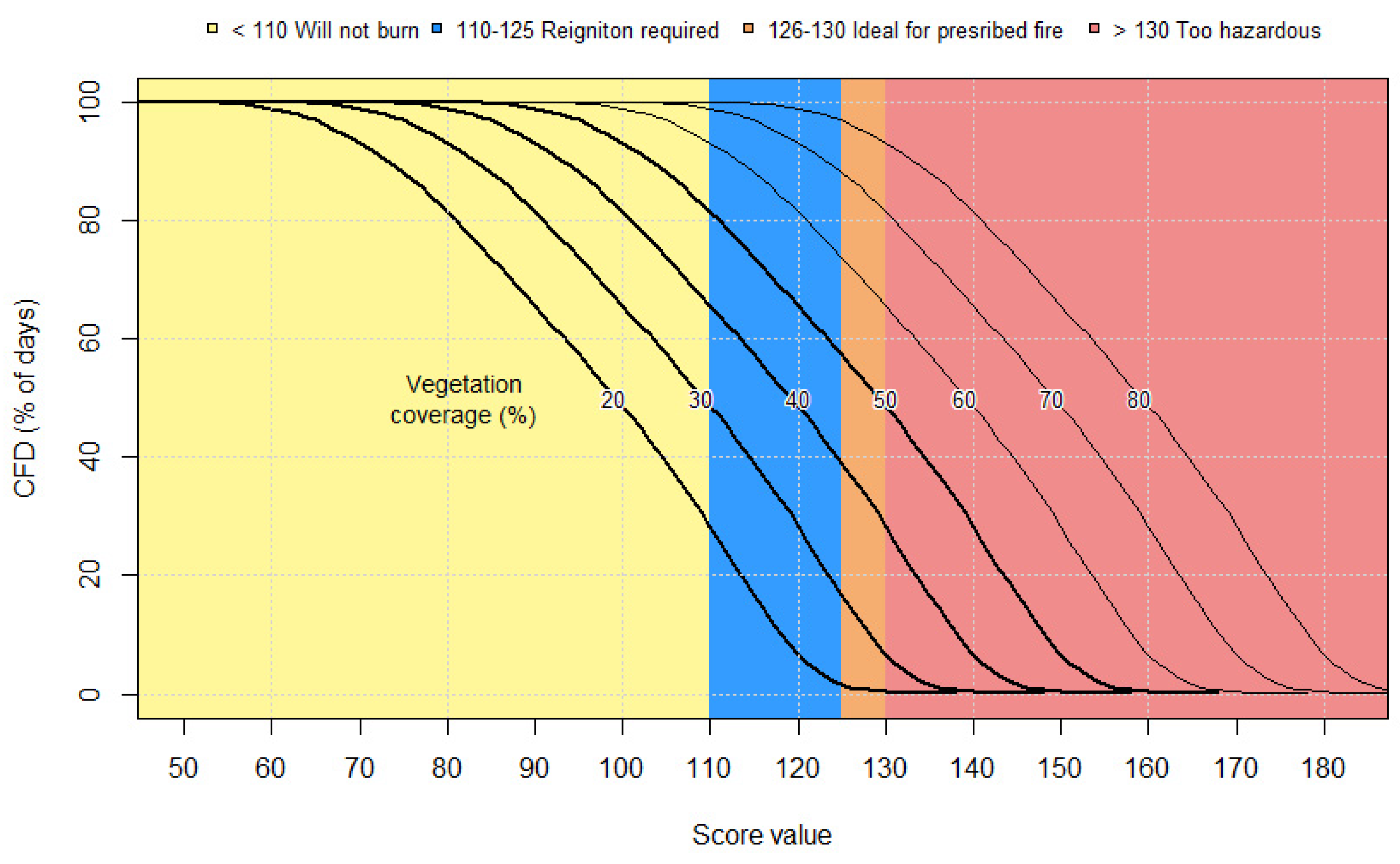
Using the RAWS weather data from 1991 to 2013 [13], a “Score” value for each day was determined using the Bruner and Klebenow [18] formula represented by Equation (2) for vegetation canopy coverages of 20, 30, 40, 50, 60, 70, and 80% and then plotted as a CFD graph.

3.1.4. FlamMap Fire Behavior Comparisons

Prior to simulation, a fuel model layer was developed using a random forests classification scheme [83] to describe existing conditions and served as input into the FlamMap spatial fire behavior modeling system [14]. Data used to map fuels and vegetation at AGCW included LiDAR derived biophysical data such as elevation and transformed aspect (TRASP), LiDAR derived vegetation height, high resolution orthoimagery (HRO) (15 cm, bands 1–4), and a normalized difference vegetation index layer (NDVI). Additionally, plot data was used to classify fuel model vegetation types. The fuel map was then classified according to the four Anderson [43] FBFMs found on AGCW and was resampled from an initial resolution of 0.5 to 30 m to reduce time requirements for simulation. The performance of three different weather scenarios were evaluated for pre- and post-fuel treatment landscapes. For the pre-treatment landscape, fire behavior outputs such as ROS, FLI, and FL were predicted for fuels as currently constituted. The area burned by the Pinyon Fire in July 2012 [1] was primarily converted to FBFM 1 to represent the most recent conditions. For post-treatment simulations, the first scenario only implemented an expansion and connection of existing firebreaks and fuelbreaks and left the rest of the fuel conditions the same.
The second group of post-treatment simulations implemented the expansion of the firebreak and fuelbreak network in addition to large scale fuel reduction treatments. The third post-treatment scenario simulated modification of the FBFMs surrounding the AGCW Multiple Purpose Machine Gun (MPMG) Range, a common source of ignitions [1]. The weather conditions of the three scenarios used in simulations were: (1) Machine Gun Fire (September 2010) weather conditions with 6.1-m open winds simulated at 48 km h−1, from a southeast to northwest direction [84]; (2) Pinyon Fire weather conditions, with 6.1-m open winds at 26 km h−1 from a north to south direction; and (3) Machine Gun Fire weather conditions (the same as Scenario 1) but with fuels surrounding the MPMG Range converted to FBFM 1. All of the fires were simulated using 1000 randomly placed fires using the minimum travel time (MTT) function of Finney [85], with the exception of the MPMG Range simulation which involved a single ignition source.

4. Results

4.1. Empirically-Based Fire Behavior Guides/Models and Fire Modeling Simulations

4.1.1. Wilson Firebreak Breaching Models for Grass–Tree/Shrubland Mixtures

Output is plotted as a CFD and arranged from highest to lowest values. To interpret a curve, a given value of x indicates the probability of firebreak breaching on the x-axis and the percent of days that exceed that value on the y-axis. For FBFM 1–Short grass (0.3 m), when trees and/or shrubs are present within 20 m of a firebreak, the probability of breaching a FW of 4.0 m, regardless of slope steepness, ranges from about 45 to 83% of the time given an ignition (Figure 1). At a FW of 8.0 m, with trees and/or shrubs present, the breaching probability ranges from near 18 to 58% of the time, regardless of the slope steepness.
The probability of breaching continues to decrease as the FW increases, with 10-m wide firebreaks with trees and/or shrubs present ranging from near 10 to 38%. For firebreaks of 15-m wide, the probability of breaching with trees and/or shrubs present is nearly obsolete, ranging from 0.0 to 10%. When trees and/or shrubs are absent within 20 m of a firebreak, a width of 4.0 m has about a 10 to 33% probability of being breached for all three slope steepness classes. When trees and/or shrubs are absent within 20 m of a firebreak, at widths of 8.0 m and greater, there is less than near a 2.0% probability of being breached.
For FBFM 2–Timber (grass and understory with trees and/or shrubs present, for all three slope steepness classes, the breaching probability ranges from near 43 to 100% (Figure 2). Even in the case of flat terrain, the probability of breaching is >60% for 58% of the days in the fire season at AGCW. For FWs of 8.0 m, with trees and/or shrubs present, the probability of breaching ranges from near 17 to 100%. However, a breaching probability of ≥60% occurs on only about 18% of the total days of record for a FW of 8.0 m. The breaching probability continues to decrease as FW increases with trees and/or shrubs present, but FWs of 10 and 15 m can have breaching probabilities as high as 100%. When trees and/or shrubs are absent from within 20 m of a firebreak, a FW of 4.0 m has from near 5 to 100% probability of being breached. Firebreak breaching is reduced dramatically as the probability of breaching of ≥60% occurs on only about 9.0% of the total number of days in a fire season. An increase in FW to 8.0 m decreases the overall probability of breaching from near zero to 70%. Breaching probabilities of 20% or greater occur about 3.0% of the time for a FW of 8.0 m during the fire season. A very small group of values within the 8.0 m FW can still have high firebreak breach probabilities, which are likely associated with extreme fire behavior and fire weather events. As the FW increases to 10 m, the probability of breaching ranges from zero to about 30%, regardless of the slope steepness. A FW of 15 m has a near zero probability of being breached.

4.1.2. Cumulative Frequency Distributions for Fire Behavior Characteristics

In the overall results for FBFM 1–Short grass (0.3 m), the FLI values ranged from <10 kW m−1 to about 5100 kW m−1 for all three slope classes (Figure 3A). Direct attack with hand tools is possible at around FLI values of <346 kW m−1 (Table S4), which occurs on about 72 to 90% of the time during the fire season. Direct attack is still possible with heavy equipment at values of <1730 kW m−1, which occurs on about 22 to 35% of the time during the fire season. Simulated FL values ranged from near zero up to 4.0 m for all three slope steepness classes (Figure 3C). At a 50% slope, about 90% of all days have FL values >1.2 m, which represents the upper limit for direct attack with hand tools. At a FL of 2.4 m, only about 20% of total number of days during the fire season were deemed beyond control by direct attack with heavy equipment. About 5.0% of days have a FL > 3.4 m, a level of fire behavior suggestive of critical fire weather conditions (Table S4). Potential maximum spotting distances were found to range from near zero to 3.0 km (Figure 3D). At terrain slope steepness levels of zero and 25%, 90% of days during the fire season were simulated to have a maximum spotting distance of up to 1.8 km. At a 50% slope, the results are similar to zero to 25% slopes, with 88% of the time having a similar potential maximum spotting distance. ROS ranged from zero to about 220 m min−1 for all three slope steepness classes (Figure 3B).
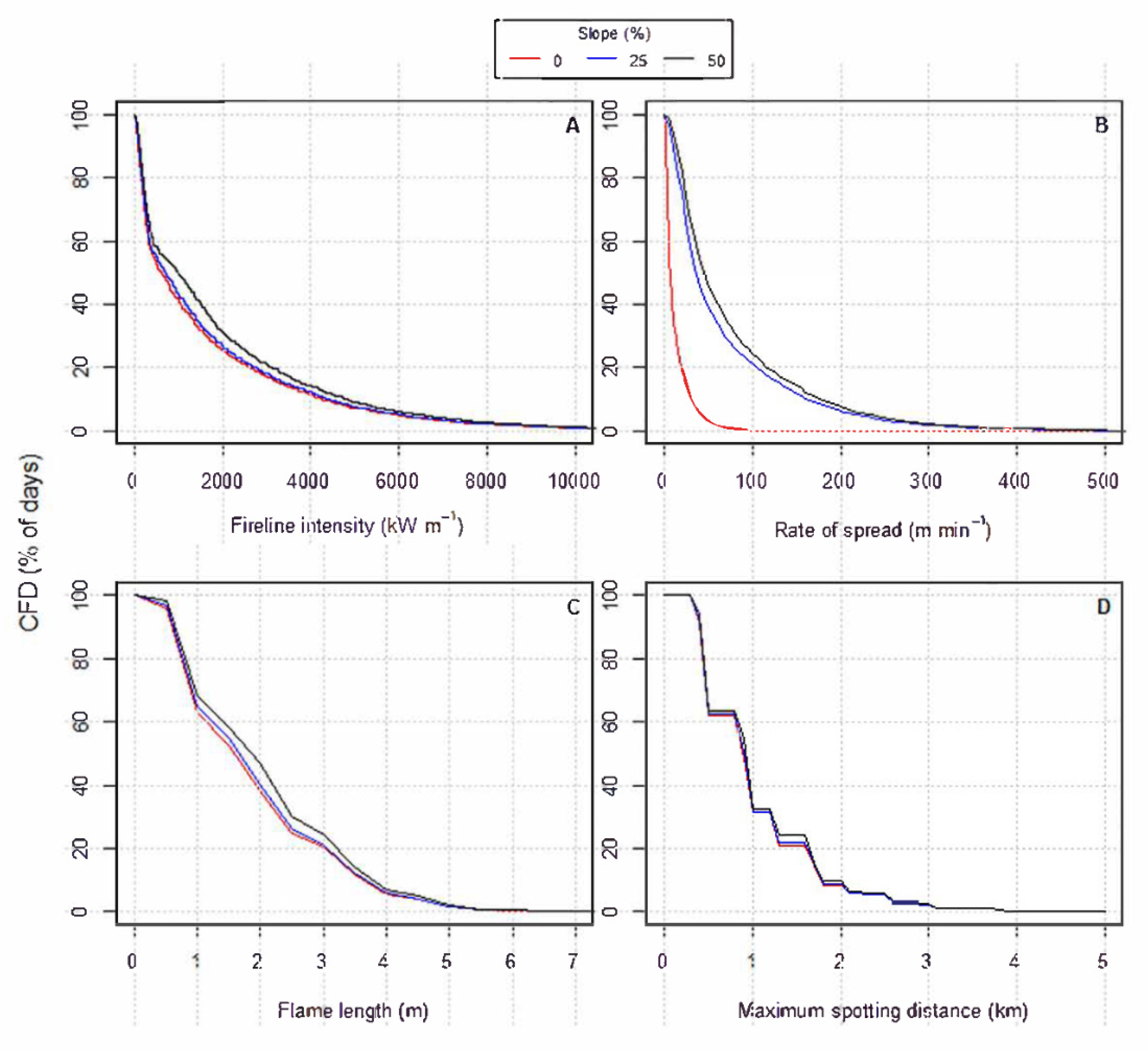
For FBFM 2–Timber (grass and understory), FLI values ranged from zero to about 25,000 kW m−1 (Figure 4A). About 95% of all days during a fire season were reported to have FLI values of >346 kW m−1, thus only 5% of total days are considered within the range of direct attack with hand tools. About 40% of the total number of days had FLI values > 1730 kW m−1, meaning that 60% of the time direct attack with heavy equipment is possible. About 23% of the time, FLI values exceed 3459 kW m−1, thereby limiting fire suppression tactics to indirect attack. FL values ranged from near zero to about 8.0 m (Figure 4C). About 30% of total days have FL values > 3.4 m and therefore require indirect attack strategies. Potential maximum spotting distances ranged from near zero up to 5.0 km (Figure 4D). Regardless of slope steepness, about 90% of days reported maximum spotting distances of about ≤2.1 km. FLI and FL values for FBFM 2 were greater than FBFM 1. However, ROS values were slightly less. Spread rates ranged widely from zero or nil fire spread to about 230 m min−1 (Figure 4B).
For FBFM 5–Brush (0.6 m), FLI values ranged from zero to about 10,000 kW m−1 (Figure 5A). About 50% of all days reported FLI values of ≥346 kW m−1; therefore, half of the total number of days in the fire season are considered within the range of direct attack with hand tools. In contrast, only about a quarter of the time were FLI values > 1730 kW m−1, meaning that 75% of the total number of days are at least within the category of direct attack by heavy equipment. About 17% of the time, FLI values were >3459 kW m−1, when direct attack is deemed ineffective. FL values ranged from near zero to about 7.0 m (Figure 5C). FL values > 3.4 m occur about 18% of the time, thereby requiring indirect attack strategies. Potential maximum spotting distances ranged from near zero to 5.0 km (Figure 5D). Regardless of the slope steepness, about 95% of days reported maximum spotting distances up to 2.1 km. ROS and FLI values for FBFM 5 were much less than FBFM 2 compared to FBFM 1; ROS was less but FLI and FL values were both higher. Spread rates also ranged widely from near 0.0 to about 100 m min−1 (Figure 5B).
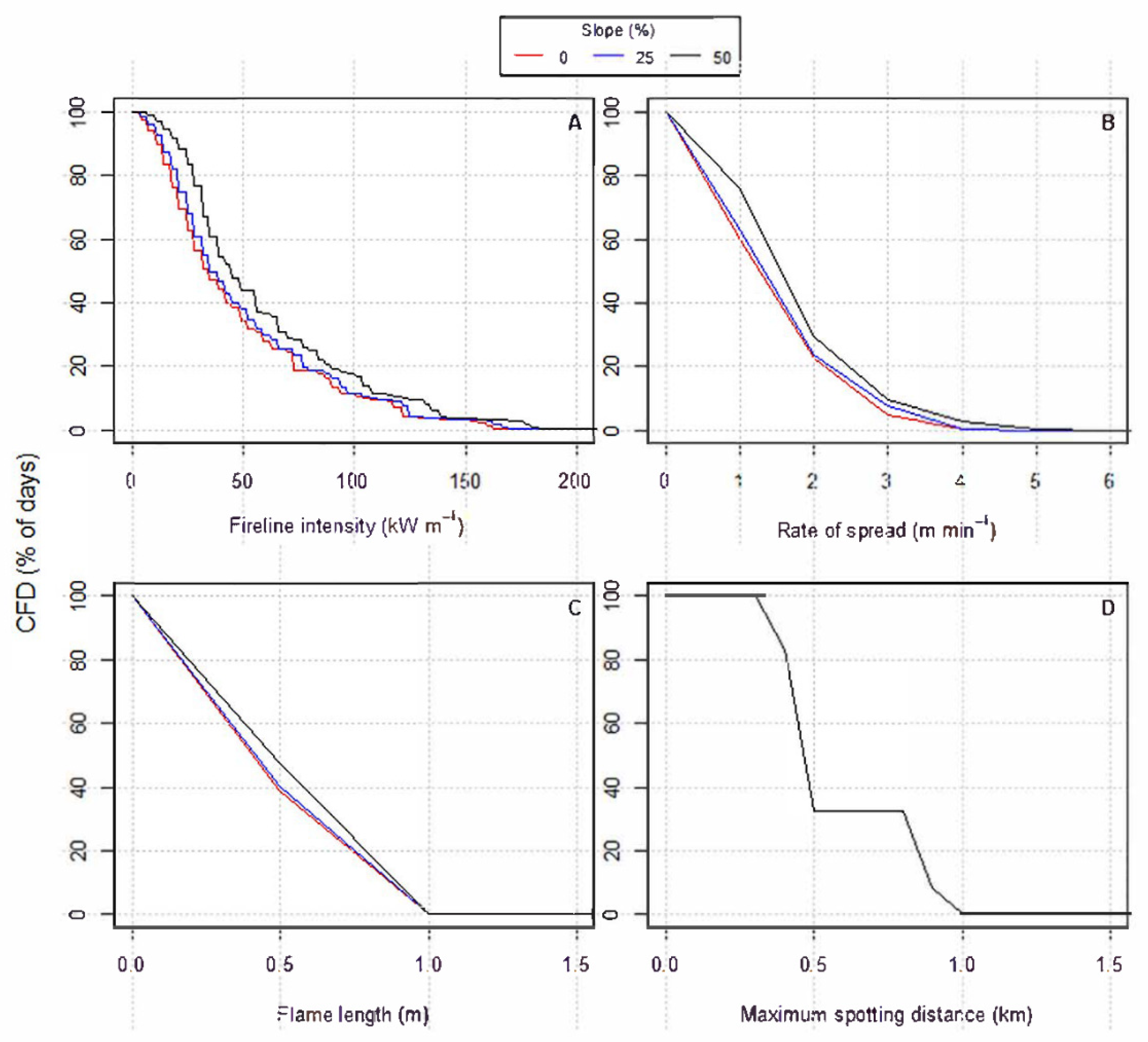
For FBFM 8–Closed timber litter, fire behavior potential was minimal across the board (Figure 6), never greater than the upper limits of allowing for direct suppression with hand tools. FLI values ranged from zero to about 200 kW m−1 (Figure 6A). FL values ranged from near zero to about 1.0 m (Figure 6C). Again, 100% of the days are still within the category of direct suppression using hand tools given an upper limit of 1.2 m. Maximum spotting distance ranged from near zero to 1.0 km (Figure 6D). ROS, FL, FLI, and maximum spotting distance values for FBFM 8 were drastically less than for all other FBFMs. Spread rates ranged from near zero to about 6.0 m min−1 (Figure 6B).
A summary of the 25th, 50th, 75th, 90th, 97th, and 99th percentiles and for the maximum computed value for each of the four fire behavior characteristics by FBFM is presented in Table 3.

4.1.3. Bruner and Klebenow Fire Behavior Guide for Pinyon-Juniper Woodlands

A CFD was again used to plot the distribution of data from highest to lowest. Both the graphical (Figure 7) and tabular (Table S6) results suggest that vegetation coverages below 30% produced by Bruner and Klebenow [18] scores were almost always less than 130. For vegetation coverages of >50%, scores above 130 were common.
Table S5 provides a summary of the area occupied by ranges of percent juniper cover. More than half (i.e., 57% of the total area) of the juniper cover at AGCW is between 20–40%. However, a large proportion of the remaining amount represents areas of cover ≥40% (i.e., 43%). Overall, there is little juniper cover remaining at AGCW after the 2012 Pinyon Fire in (474 ha), which likely burnt more than half of the juniper vegetation on the base. A map of the typical percent vegetation cover (Figure S9) was also produced to provide spatial guidance for the natural resource managers at AGCW.

4.1.4. FlamMap Fire Behavior Comparisons

FlamMap requires a raster-based input representing the fuels profile to produce modeled outputs. Accuracy of simulation results compared to actual fire extent and behavior is difficult to attain due to model assumptions (see Section 2.2). Furthermore, in lower elevation, non-forested fuel types such as those located at AGCW, there has been little research done to validate predicted fire behavior from modeling output to actual fire behavior. Frost et al. [84] attempted to do such a comparison, using BehavePlus output to compare predicted to observed rate of spread for the 2010 Machine Gun Fire.
The results of the FlamMap simulations are summarized in Table 4. The weather conditions of the 2010 Machine Gun Fire [84] were the most severe, whereas the 2012 Pinyon Fire weather represented conditions ranging between moderate and severe. For both circumstances, fire behavior was reduced through treatment implementation. The firebreak and fuelbreak expansion plus the landscape treatment was the most successful at reducing fire behavior for each simulation scenario. FL values exceeded 1.2 m, except in the case of the 2012 Pinyon Fire, where FL values were reduced on average to 1.2 m in the firebreaks plus landscape treatment scenario. For the 2012 Pinyon Fire, with conditions exhibiting less severe fuel moisture values in Gambel oak and lower wind speeds, the simulations predicted that fire behavior would potentially be reduced enough to allow for direct suppression action. For the treatments surrounding ignition sources as exemplified by the MPMG Range simulation, the ROS actually increased for the fuelbreaks only treatment and the FL remained nearly the same. Conversion to FBFM 1 assumes near continuous grass, thus supporting an increased rate of fire spread. However, as discussed earlier in the Wilson [75] firebreak evaluations, if woody vegetation was removed within 20 m of firebreaks surrounding the MPMG Range, with a firebreak width of 8.0 m, the probability of breaching in grass and tree/shrub conditions is typically less than 5.0%. The likely reduction in fire behavior after treatments would usually be expected to be much lower than the results indicate here. This is likely due to the resolution of simulation (30 m), and the difficulty of capturing linear break features of smaller resolution (4.0, 8.0, 10, 15 m) through simulations in FlamMap. Therefore, it is likely that fire behavior projections would indicate a more dramatic reduction in fire behavior for the breaks only and the landscape treatments plus breaks scenarios if linear breaks were better recognized.

5. Discussion

The desired condition at AGCW is a fuel type mosaic modified to reduce ROS, FL, FLI, and probability of firebreak breaching via direct flame contact or spotting. This could take the form of an organized network of firebreaks, fuelbreaks, and fuel treatments that reduce the probability of large wildfires escaping installation boundaries. The firebreak and fuelbreak network at AGCW are already extensive and an expansion of the network would only need to occur in a few strategic areas. Firebreaks, where vegetation is removed to bare mineral soil, should have a minimum width of 8.0 m with woody vegetation removed within 20 m on both sides of the firebreak. For small firebreaks and roads, a good general test for estimating firebreak breach by flame contact (in the absence of spotting) is to use Byram’s [45] rule of thumb, which suggests minimum firebreak width should be equal to flame length times 1.5. Results also suggest that the ROS in pinyon-juniper stands can be reduced by maintaining stand densities at vegetation coverages of near 30% or less. Due to past large wildfires, especially the 2012 Pinion Fire, the presence of juniper vegetation has become quite sparse at AGCW. Treatment priority in juniper should typically be low for the next 10 to 20 years, except in WUI areas of concern. It is important to note that the equations of Wilson [75] were developed in grasslands with scattered shrubs and trees, and applying it to the other vegetation types such as pinyon-juniper and Gambel oak at AGCW would in all likelihood lead to erroneous conclusions. Likewise, the guide of Bruner and Klebenow [18] was developed to predict general fire behavior potential in pinyon-juniper and should not be applied to other vegetation types on AGCW.
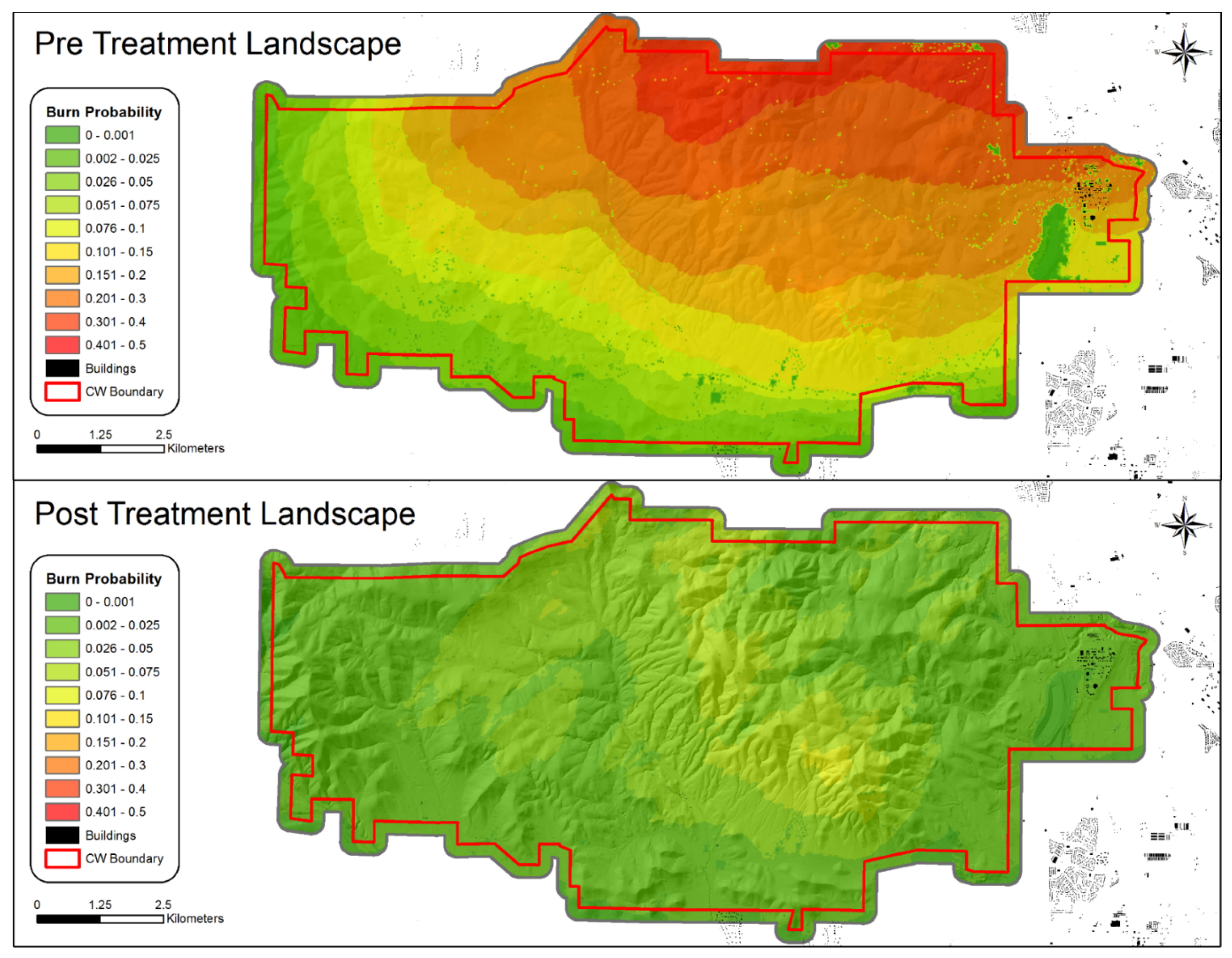
In addition to the fire behavior predictions, the probability that a given pixel will burn was simulated (Table 4; Figure 8), also employing the MTT function in FlamMap. The simulation also used 1000 randomly placed fires within the boundaries of AGCW to obtain this probability. Burn probabilities were not obtained for the MPMG scenario because FlamMap does not allow for calculation of single point source ignitions. Burn probability for both treatments was drastically reduced (especially for the 2010 Machine Gun Fire weather conditions, reduction of 89%) compared to the pretreatment landscape.
There is evidence to suggest that roads can act as disturbance corridors that promote invasion by annual exotics [86]. Land Cover Trend Analysis plots [87] already in place at AGCW could be used to monitor potential vegetation changes as a result of firebreak maintenance. Fuelbreaks at AGCW are primarily located along the northern boundary in Gambel oak vegetation. During late fire season conditions, typically from August to October, once the foliar moisture content of Gambel oak is less than 120 percent, the potential for extreme fire behavior is likely under extreme fire weather conditions (F. Romero, USDA Forest Service, National Interagency Fire Center, Boise, Idaho, personal communication, February 2014). This scenario occurred during the 2010 Machine Gun Fire [84] when live fuel moisture content was 81% [77]. Fires in Gambel oak under these dry conditions can behave much like fire in oak during the 1994 South Canyon Fire fatalities [61], the 2002 Price Canyon Fire entrapment [88], and chaparral fuel complexes in Southern California [89].
Following the recommendations for fuelbreak development made by Green [3] in California, fuelbreaks should be organized in a connected system of primary and secondary fuelbreaks. The recommended width for a secondary fuelbreak is 60 m and 90 m for a primary fuelbreak. This network of fuelbreaks would ideally segment land area at AGCW into 1000 ha blocks or parcels that would facilitate suppression access and burnout operations if required. The arrangement of training areas and the associated roads and breaks currently in place at AGCW is already close to achieving this condition. Combining a firebreak/fuelbreak network with landscape treatments will increase the likelihood of success when managed in a systematic manner including scheduling updates as needed. Considerations for treatment type should be based on safety, cost, manpower commitment, ecological impacts (e.g., soil erosion), risk to the WUI, and the effect of vegetation modification on military training operations. Most often treatment types will be used in combination [90]. For example, hand thinning may occur in a treatment block followed by winter pile burning to remove the residual biomass.
Applying semi-empirical models that are applicable to local fuel types to predict fire behavior in combination with processing climatological data to create a distribution of predicted fire behavior is a novel approach in non-forested ecosystems like the sagebrush steppe. Modeling fire behavior through spatial fire spread software programs akin to FlamMap [14] are valuable tools to explore alternative treatment options but are difficult to validate. The approach taken here used semi-empirical based models or guidelines wherever possible (e.g., [18,75]), and combined them with predictions from traditional fire behavior modeling systems such as BehavePlus [42] and FlamMap [14]. This approach is recommended for future assessments regarding fuel treatments given the inherent assumptions and limitations of fire behavior models and guidelines [38].

Supplementary Materials

The following supporting information can be downloaded at https://www.mdpi.com/article/10.3390/fire5030078/s1: reference numbers to those cited in the Supplementary Materials, not the text [91,92]. TableS1: General fuel treatment methods and their pros/cons at Army Garrison Camp Williams. Table S2: Maximum spotting distance (km) look-up table for non-canopied fuel types as a function of flame length (FL) and 10-m open wind speed (from Alexander [4]), Table S3: Four scenarios for combination of dead fuel moisture contents by time-lag (TL) size and live fuel moistures as used by Scott and Burgan [10] for making fire behavior simulations, Table S4: Interpretation diagnostics for fire suppression tactics as outlined by Andrews and Rothermel [11] based on fire-line intensity and flame length, Table S5: Area of juniper cover at Army Garrison Camp Williams, UT, and the proportion of total area by percent canopy cover classes, Figure S1: Observed versus predicted rates of spread for experimental fires and wildfires in grasslands by Sneeuwjagt and Frandsen [1] and experimental fires in sagebrush shrublands by Bushey [2] compared to predictions from Rothermel’s [3] surface fire spread model, Figure S2: Conceptual representation of the two scenarios involved in the models of Wilson [6] for estimating the probability of grassland firebreak breaching. Figure S3: Graphical representation of the two probability of firebreak breaching models developed by Wilson [6] for grassland fires as a function of fire-line intensity and firebreak width and whether or not trees and/or shrubs were present or absent within 20 m of the firebreak (after Alexander et al. [7]), Figure S4: BehavePlus simulation results for “very low”, “low”, “moderate”, and “high” fuel moisture scenario conditions and wind speed for Anderson [9] Fire Behavior Fuel Model 1–Short grass (0.3 m).Figure S5: BehavePlus simulation results for “very low”, “low”, “moderate”, and “high” fuel moisture scenario conditions and wind speed for Anderson [9] Fire Behavior Fuel Model 2–Timber (grass and understory), Figure S6: BehavePlus simulation results for “very low”, “low”, “moderate”, and “high” fuel moisture scenario conditions and wind speed for Anderson [9] Fire Behavior Fuel Model 5–Brush (0.6 m), Figure S7: BehavePlus simulation results for “very low”, “low”, “moderate”, and “high” fuel moisture scenario conditions and wind speed for Anderson [9] Fire Behavior Fuel Model 8–Closed timber litter, Figure S8: BehavePlus simulation results for “very low”, “low”, “moderate”, and “high” fuel moisture scenario conditions and wind speed for Anderson [9] Fire Behavior Fuel Model 6–Dormant brush. Figure S9: Map of percent juniper canopy cover at Army Garrison Camp Williams, UT, updated to reflect the post-burn vegetation coverage of juniper following the 2012 Pinyon Fire.

Author Contributions

Conceptualization, S.M.F., M.E.A. and M.J.J.; data curation, S.M.F.; formal analysis, S.M.F.; funding acquisition, M.E.A. and M.J.J.; investigation, S.M.F., M.E.A. and M.J.J.; methodology, S.M.F., M.E.A. and M.J.J.; project administration, M.J.J.; supervision, M.E.A. and M.J.J.; writing—original draft, S.M.F.; writing—review and editing, M.E.A. and M.J.J. All authors have read and agreed to the published version of the manuscript.

Funding

This research was supported by funding from the Utah National Guard, Army Garrison Camp Williams. This research was supported by the Utah Agricultural Experiment Station, Utah State University.

Institutional Review Board Statement

Not applicable.

Informed Consent Statement

Not applicable.

Data Availability Statement

Processed data, products, and code produced in this study are available from the corresponding author upon reasonable request.

Acknowledgments

Many thanks to Wanda Lindquist for the countless hours of help and effort expended to batch process fire behavior output. I am very appreciative of the time and advice given freely by Dave Thomas and for the many reviews of figures and texts. I also want to thank Doug Johnson and Sean Hammond of the Utah National Guard for their help in providing guidance and answering questions throughout the research process. Thanks to Miguel Cruz (CSIRO Australia) for the provision of Figures S1 and S3. We would also like to acknowledge the technical assistance and advice offered by Doug Ramsey, Cyndi Sidels, Faith Ann Heinsch, Daniel Huisjen, and Joe Scott. Funding for this project was provided by the Utah National Guard, Army Garrison Camp Williams.

Conflicts of Interest

The authors declare no conflict of interest.

References

  1. Frost, S.M.; Jenkins, M.; Alexander, M.E. Fire regime analysis of Army Garrison. In The Fire Continuum—Preparing for the Future of Wildland Fire: Proceedings of the Fire Continuum Conference, Missoula, MT, USA, 21–24 May 2018; Hood, S., Drury, S., Steelman, T., Steffens, R., Eds.; Proc. RMRS-P-78; USDA Forest Service, Rocky Mountain Research Station: Fort Collins, CO, USA, 2020; pp. 264–266. [Google Scholar]
  2. Williams, C.W.G. Integrated Wildland Fire Management Plan; Utah Army National Guard, Environmental Resources Management: Riverton, UT, USA, 2011; pp. 1–114. [Google Scholar]
  3. Green, L.R. Fuelbreaks and Other Fuel Modification for Wildland Fire Control. In Agriculture Handbook; No. 499; USDA Forest Service: Washington, DC, USA, 1977; pp. 1–79. [Google Scholar]
  4. Cochrane, M.A.; Moran, C.J.; Wimberly, M.C.; Baer, A.D.; Finney, M.A.; Beckendorf, K.L.; Eidenshink, J.; Zhu, Z. Estimation of wildfire size and risk changes due to fuels treatments. Int. J. Wildland Fire 2012, 21, 357–367. [Google Scholar] [CrossRef] [Green Version]
  5. Davies, K.W.; Bates, J.D.; Madsen, M.D.; Nafus, A.M. Restoration of mountain big sagebrush steppe following prescribed burning to control western juniper. Environ. Manag. 2014, 53, 1015–1022. [Google Scholar] [CrossRef] [PubMed]
  6. Agee, J.K.; Skinner, C.N. Basic principles of forest fuel reduction treatments. For. Ecol. Manag. 2005, 211, 83–96. [Google Scholar] [CrossRef]
  7. Connelly, J.; Schroeder, M.A.; Bralln, C.E. Guidelines to manage sage grouse populations and their habitats. Wildl. Soc. Bull. 2014, 28, 967–985. [Google Scholar]
  8. Stratton, R.D. Assessing the effectiveness of landscape fuel treatments on fire growth and behavior. J. For. 2004, 102, 32–40. [Google Scholar]
  9. Smith, E.G.; Davison, J.C.; Brackley, G.K. Controlled Sheep Grazing to Create Fuelbreaks along the Urban/Wildland Interface of Western Nevada. In Proceedings of the 53rd Annual Meeting of the Society for Range Management, Boise, ID, USA, 13–18 February 2000; Society of Range Management: Wichita, KS, USA, 2000; pp. 73–74. [Google Scholar]
  10. Dellasala, D.A.; Williams, J.E.; Williams, C.D.; Franklin, J.F.; Fund, W.W.; Way, L. Beyond smoke and mirrors: A synthesis of fire policy and science. Conserv. Biol. 2004, 18, 976–986. [Google Scholar] [CrossRef]
  11. Washa, J.B. Hazardous Fuels Treatment Effectiveness on Utah BLM Lands. In Proceedings of the Program Booklet—Interior West Fire Ecology Conference: Challenges and Opportunities in a Changing World, Snowbird, UT, USA, 14–17 November 2011; Association of Fire Ecology: Redlands, CA, USA, 2011; p. 70. [Google Scholar]
  12. Frost, S.M. Fire Environment Analysis at Army Garrison Camp Williams in Relation to Fire Behavior Potential for Gauging Fuel Modification Needs. Master’s Thesis, Utah State University, Logan, UT, USA, 2015; pp. 1–183. [Google Scholar]
  13. Frost, S.M.; Alexander, M.E.; DeRose, R.J.; Jenkins, M.J. Fire-environment analysis: An example of Army Garrison Camp Williams, Utah. Fire 2020, 3, 6. [Google Scholar] [CrossRef]
  14. Finney, M.A. An overview of FamMap fire modeling capabilities. In Fuels Management—How to Measure Success, Conference Proceedings, Portland, OR, USA, 28–30 March 2006; Andrews, P.L., Butler, B.W., Eds.; Proc. RMRS-P-41; USDA Forest Service, Rocky Mountain Research Station: Fort Collins, CO, USA, 2006; pp. 107–123. [Google Scholar]
  15. Martinson, E.J.; Omi, P.N. Assessing mitigation of wildfire severity by fuel treatments—An example from the Coastal Plain of Mississippi. Int. J. Wildland Fire 2008, 17, 415–420. [Google Scholar] [CrossRef]
  16. Strom, B.A.; Fulé, P.Z. Pre-wildfire fuel treatments affect long-term ponderosa pine forest dynamics. Int. J. Wildland Fire 2007, 16, 128–138. [Google Scholar] [CrossRef]
  17. Davies, K.W.; Bates, J.D.; Svejcar, T.J.; Boyd, C.S. Effects of long-term livestock grazing on fuel characteristics in rangelands: An example from the sagebrush steppe. Rangel. Ecol. Manag. 2010, 63, 662–669. [Google Scholar] [CrossRef]
  18. Bruner, A.D.; Klebenow, D.A. Predicting Success of Prescribed Fires in Pinyon-juniper Woodland in Nevada; Research Paper; INT-219; USDA Forest Service, Intermountain Forest and Range Experiment Station: Ogden, UT, USA, 1979; pp. 1–12. [CrossRef]
  19. Eidenshink, J.; Schwind, B.; Brewer, K.; Zhu, Z.; Quayle, B.; Howard, S.; Falls, S. A project for monitoring trends in burn severity. Fire Ecol. 2007, 3, 3–21. [Google Scholar] [CrossRef]
  20. Wang, C.; Glenn, N.F. Estimation of fire severity using pre- and post-fire LiDAR data in sagebrush steppe rangelands. Int. J. Wildland Fire 2009, 18, 848–856. [Google Scholar] [CrossRef] [Green Version]
  21. Finney, M.A. Design of regular landscape fuel treatment patterns for modifying fire growth and behavior. For. Sci. 2001, 47, 219–228. [Google Scholar]
  22. Andrews, P.L.; Bevins, C.D.; Seli, R.C. BehavePlus Fire Modeling System, Version 4.0: User’s Guide; General Technical Report; RMRS-GTR-106WWW; USDA Forest Service, Rocky Mountain Research Station: Fort Collins, CO, USA, 2008; pp. 1–123.
  23. Andrews, P.L. Current status and future needs of the BehavePlus Fire Modeling System. Int. J. Wildland Fire 2014, 23, 21–33. [Google Scholar] [CrossRef] [Green Version]
  24. Finney, M.A. FARSITE: Fire Area Simulator—Model Development and Evaluation; Research Paper; RMRS-RP-4; USDA Forest Service, Rocky Mountain Research Station: Ogden, UT, USA, 2004; pp. 1–47. [CrossRef]
  25. Scott, J.H. NEXUS: A system for assessing crown fire hazard. Fire Manag. Notes 1999, 59, 20–24. [Google Scholar]
  26. Scott, J.C.; Reinhardt, E.D. Assessing Crown Fire Potential by Linking Models of Surface and Crown Fire Behavior; Research Paper; RMRS-RP-29; USDA Forest Service, Rocky Mountain Research Station: Fort Collins, CO, USA, 2001; pp. 1–59. [CrossRef] [Green Version]
  27. Rothermel, R.C. A Mathematical Model for Predicting Fire Spread in Wildland Fuels; Research Paper; INT-115; USDA Forest Service, Intermountain Forest and Range Experiment Station: Ogden, UT, USA, 1972; pp. 1–41.
  28. Andrews, P.L. The Rothermel Surface Fire Spread Model and Associated Developments: A Comprehensive Explanation; General Technical Report; RMRS-INT-371; USDA Forest Service, Rocky Mountain Research Station: Fort Collins, CO, USA, 2018; pp. 1–121. [CrossRef]
  29. Burgan, R.E. Fire Danger/Fire Behavior Computations with the Texas Instruments TI-59 Calculator: User’s Manual; General Technical Report; INT-61; USDA Forest Service, Intermountain Forest and Range Experiment Station: Ogden, UT, USA, 1979; pp. 1–25.
  30. Andrews, P.L. BEHAVE: Fire Behavior Prediction and Fuel Modeling System—BURN Subsystem, Part 1; General Technical Report; INT-194; USDA Forest Service, Intermountain Forest and Range Experiment Station: Ogden, UT, USA, 1986; pp. 1–130.
  31. Rothermel, R.C. How to Predict the Spread and Intensity of Forest and Range Fires; General Technical Report; INT-143; USDA Forest Service, Intermountain Forest and Range Experiment Station: Ogden, UT, USA, 1983; pp. 1–161. [CrossRef]
  32. Brown, J.K. Fuel and Fire Behavior Predictions in Big Sagebrush; Research Paper; INT-290; USDA Forest Service, Intermountain Forest and Range Experiment Station: Ogden, UT, USA, 1982; pp. 1–10. [CrossRef] [Green Version]
  33. Rothermel, R.C.; Rinehart, G.C. Field Procedures for Verification and Adjustment of Fire Behavior Predictions; General Technical Report; INT-142; USDA Forest Service, Intermountain Forest and Range Experiment Station: Ogden, UT, USA, 1983; pp. 1–25. [CrossRef]
  34. Butler, B.W.; Reynolds, T.D. Wildfire Case Study: Butte City Fire, Southeastern Idaho, 1 July 1994; General Technical Report; INT-GTR-351; USDA Forest Service, Intermountain Research Station: Ogden, UT, USA, 1997; pp. 1–15.
  35. Sneeuwjagt, R.J.; Frandsen, W.H. Behavior of experimental grass fires vs. predictions based on Rothermel’s fire model. Can. J. For. Res. 1977, 7, 357–367. [Google Scholar] [CrossRef]
  36. Bushey, C.J. Comparison of observed and predicted fire behavior in the sagebrush/bunchgrass vegetation type. In Fire Management: The Challenge of Protection and Use, Proceedings of a Symposium, Logan, UT, USA, 17–19 April 1985; Long, J.N., Ed.; Utah State University: Logan, UT, USA, 1986; pp. 187–201. [Google Scholar]
  37. Cruz, M.G.; Alexander, M.E. Uncertainty associated with model predictions of surface and crown fire rates of spread. Environ. Model. Softw. 2013, 47, 16–28. [Google Scholar] [CrossRef]
  38. Alexander, M.E.; Cruz, M.G. Limitations on the accuracy of model predictions of wildland fire behaviour: A state-of-the-knowledge overview. For. Chron. 2013, 89, 370–381. [Google Scholar] [CrossRef]
  39. Cruz, M.G.; Gould, J.S.; Alexander, M.E.; Sullivan, A.L.; McCaw, W.L.; Matthews, S. A Guide to Rate of Fire Spread Models for Australian Vegetation, Rev. ed.; CSIRO Land and Water Flagship and Australasian Fires Authorities Council: Canberra, Australia; Melbourne, Australia, 2015; pp. 1–125. [Google Scholar]
  40. Alexander, M.E. Are we abusing our use of models and modelling in wildland fire and fuel management? Fire Manag. Today 2009, 69, 24–27. [Google Scholar]
  41. Albini, F.A. Estimating Wildfire Behavior and Effects; General Technical Report; INT-30; USDA Forest Service, Intermountain Forest and Range Experiment Station: Ogden, UT, USA, 1976; pp. 1–92.
  42. Heinsch, F.A.; Andrews, P.L. BehavePlus Fire Modeling System, Version 5.0: Design and Features; General Technical Report; RMRS-GTR-249; USDA Forest Service, Rocky Mountain Research Station: Fort Collins, CO, USA, 2010; pp. 1–111.
  43. Anderson, H.E. Aids to Determining Fuel Models for Estimating Fire Behavior; General Technical Report; INT-122; USDA Forest Service, Intermountain Forest and Range Experiment Station: Ogden, UT, USA, 1982; pp. 1–22. [CrossRef] [Green Version]
  44. Scott, J.H.; Burgan, R.E. Standard Fire Behavior Fuel Models: A Comprehensive Set for Use with Rothermel’s Surface Fire Spread Model; General Technical Report; RMRS-GTR-153; USDA Forest Service, Rocky Mountain Research Station: Fort Collins, CO, USA, 2005; pp. 1–72. [CrossRef]
  45. Byram, G.M. Combustion of forest fuels. In Forest Fire: Control and Use; Davis, K.P., Ed.; McGraw-Hill: New York, NY, USA, 1959; pp. 61–89. [Google Scholar]
  46. Alexander, M.E.; Cruz, M.G. Interdependencies between flame length and fireline intensity in predicting crown fire initiation and crown scorch height. Int. J. Wildland Fire 2012, 21, 95–113. [Google Scholar] [CrossRef]
  47. Albini, F.A. Spot Fire Distance from Burning Trees—A Predictive Model; General Technical Report; INT-56; USDA Forest Service, Intermountain Forest and Range Experiment Station: Ogden, UT, USA, 1979; pp. 1–73.
  48. Albini, F.A. Spot Fire Distance from Isolated Sources—Extensions of a Predictive Model; Research Note; INT-309; USDA Forest Service, Intermountain Forest and Range Experiment Station: Ogden, UT, USA, 1981; pp. 1–9.
  49. Albini, F.A. Potential Spotting Distance from Wind-driven Surface Fires; Research Paper; INT-309; USDA Forest Service, Intermountain Forest and Range Experiment Station: Ogden, UT, USA, 1983; pp. 1–27.
  50. Morris, G.A., Jr. A Simple Method for Computing Spotting Distances from Wind-driven Surface Fires; Research Note; INT-374; USDA Forest Service, Intermountain Research Station: Ogden, UT, USA, 1987; pp. 1–6.
  51. Weir, J.R. Probability of spot fires during prescribed burns. Fire Manag. Today 2004, 64, 24–26. [Google Scholar]
  52. Albini, F.A.; Alexander, M.E.; Cruz, M.G. A mathematical model for predicting the maximum potential spotting distance from a crown fire. Int. J. Wildland Fire 2012, 21, 609–627. [Google Scholar] [CrossRef]
  53. Andrews, P.L.; Chase, C.H. BEHAVE: Fire Behavior Prediction and Fuel Modeling System—BURN Subsystem, Part 2; General Technical Report; INT-260; USDA Forest Service, Intermountain Research Station: Ogden, UT, USA, 1989; pp. 1–93. [CrossRef] [Green Version]
  54. Hester, D.A. The pinyon-juniper fuel type can really burn. Fire Contr. Notes 1952, 13, 26–29. [Google Scholar]
  55. Mutch, R.W. Cheatgrass coloration—A key to flammability? J. Range Manag. 1967, 20, 259–260. [Google Scholar] [CrossRef]
  56. Wright, H.A.; Neuenschwander, L.F.; Britton, C.M. The Role and Use of Fire in Sagebrush-grass and pinyon-juniper Plant Communities: A State-of-the-Art Review; General Technical Report; INT-58; USDA Forest Service, Intermountain Forest and Range Experiment Station: Ogden, UT, USA, 1979; pp. 1–48.
  57. Ogle, K.A. Influence of Moisture Content in Gambel Oak Leaves on Waterton Canyon Fire Behavior. Master’s Thesis, Colorado State University, Fort Collins, CO, USA, 1989; pp. 1–63. [Google Scholar]
  58. Neuenschwander, L.F. Broadcast burning of sagebrush in winter. J. Range Manag. 1980, 33, 233–236. [Google Scholar] [CrossRef]
  59. Jester, N.; Rogers, K.; Dennis, F.C. Gambel oak management. In Natural Resources Series/Forestry Fact Sheet; No. 6.311 Revised; Colorado State University Extension and Colorado State Forest Service: Fort Collins, CO, USA, 2012; pp. 1–3. [Google Scholar]
  60. Traylor, R.E. Correlation of Weather to Fire Spread in Grass and Brushland Fuel Types on the Snake River Plains of Southeastern Idaho. Master’s Thesis, Montana State University, Bozeman, MT, USA, 1961; p. 123. [Google Scholar]
  61. Butler, B.W.; Bartlette, R.A.; Bradshaw, L.S.; Cohen, J.D.; Andrews, P.L.; Putnam, T.; Mangan, R.J. Fire Behavior Associated with the 1994 South Canyon Fire on Storm King Mountain, Colorado; Research Paper; RMRS-RP-9; USDA Forest Service, Rocky Mountain Research Station: Fort Collins, CO, USA, 1998; pp. 1–82. [CrossRef] [Green Version]
  62. Hudak, A.T.; Rickert, I.; Morgan, P.; Strand, E.; Lewis, S.A.; Robichaud, P.R.; Hoffman, C.; Holden, Z.A.; Andrew, T.; Sarah, A.; et al. Review of Fuel Treatment Effectiveness in Forests and Rangelands and a Case Study from the 2007 Megafires in Central Idaho USA; General Technical Report; RMRS-GTR-252; USDA Forest Service, Rocky Mountain Research Station: Fort Collins, CO, USA, 2011; pp. 1–60.
  63. Baker, W.L.; Shinneman, D.J. Fire and restoration of piñon–juniper woodlands in the western United States: A review. For. Ecol. Manag. 2004, 189, 1–21. [Google Scholar] [CrossRef]
  64. McIver, J.; Brunson, M.W.; Bunting, S.; Chambers, J.; Devoe, N. The Sagebrush Steppe Treatment Evaluation Project (SageSTEP): A Test of State-and-Transition Theory; General Technical Report; RMRS-GTR-237; USDA Forest Service, Rocky Mountain Research Station: Fort Collins, CO, USA, 2010; pp. 1–16. [CrossRef]
  65. Miller, R.F.; Tausch, R.J. The role of fire in juniper and pinyon woodlands: A descriptive analysis. In The Role of Fire in the Control and Spread of Invasive Species, Proceedings of the Invasive Species Workshop, San Diego, CA, USA, 27 November–1 December 2000; Galley, K.E.M., Wilson, T.P., Eds.; Misc. Publ. No. 11; Tall Timbers Research Station: Tallahassee, FL, USA, 2001; pp. 15–30. [Google Scholar]
  66. Bates, J.D.; Davies, K.W.; Sharp, R.N. Shrub-steppe early succession following juniper cutting and prescribed fire. Environ. Manag. 2011, 47, 468–481. [Google Scholar] [CrossRef]
  67. Fulé, P.Z.; Waltz, A.E.M.; Covington, W.W.; Heinlein, T.A. Measuring forest restoration effectiveness in reducing hazardous fuels. J. For. 2001, 99, 24–29. [Google Scholar]
  68. Stevens-Rumann, C.; Shive, K.; Fulé, P.; Sieg, C.H. Pre-wildfire fuel reduction treatments result in more resilient forest structure a decade after wildfire. Int. J. Wildland Fire 2013, 22, 1108–1117. [Google Scholar] [CrossRef]
  69. Lovreglio, R.; Meddour-Sahar, O.; Leone, V. Goat grazing as a wildfire prevention tool: A basic review. iFor. Biogeosci. For. 2014, 7, 260–268. [Google Scholar] [CrossRef] [Green Version]
  70. Ralphs, M.E.; Busby, F.E. Prescribed burning: Vegetative change, forage production, cost, and returns on six demonstration burns in Utah. J. Range Manag. 1979, 32, 267–270. [Google Scholar] [CrossRef] [Green Version]
  71. Diamond, J.M.; Call, C.A.; Devoe, N. Effects of targeted cattle grazing on fire behavior of cheatgrass-dominated rangeland in the northern Great Basin, USA. Int. J. Wildland Fire 2009, 18, 944–950. [Google Scholar] [CrossRef]
  72. Strand, E.K.; Launchbaugh, K.L.; Limb, R.; Torell, L.A. Livestock grazing effects on fuel loads for wildland fire in sagebrush dominated ecosystems. J. Range. Appl. 2014, 1, 35–57. [Google Scholar]
  73. Cheney, P.; Sullivan, A. Grassfires: Fuel, Weather and Fire Behaviour, 2nd ed.; CSIRO Publishing: Collingwood, Australia, 2008; pp. 1–160. [Google Scholar]
  74. Davidson, S. Predicting the effectiveness of firebreaks. Rural Res. 1988, 139, 11–16. [Google Scholar]
  75. Wilson, A.A.G. Width of firebreak that is necessary to stop grass fires: Some field experiments. Can. J. For. Res. 1988, 18, 682–687. [Google Scholar] [CrossRef]
  76. Cheney, N.P.; Gould, J.S.; Catchpole, W.R. The influence of fuel, weather and fire shape variables on fire-spread in grasslands. Int. J. Wildland Fire 1993, 3, 31–44. [Google Scholar] [CrossRef]
  77. USFS-WFAS. United States Forest Service: Wildland Fire Assessment System. National Fuel Moisture Database. 2014. Available online: http://www.wfas.net/index.php/national-fuel-moisture-database-moisture-drought-103 (accessed on 15 March 2014).
  78. RMRS; SEM. Rocky Mountain Research Station Fire Sciences Laboratory and Systems for Environmental Management. In FireFamilyPlus User’s Guide; Version 3.0; USDA Forest Service, National Fire and Aviation Management Information Systems Team: Boise, ID, USA, 2002; pp. 1–124. [Google Scholar]
  79. Bradshaw, L.S.; Deeming, J.E.; Burgan, R.E.; Cohen, J.D. The 1978 National Fire-Danger Rating System: Technical Documentation; General Technical Report; INT-169; USDA Forest Service, Intermountain Forest and Range Experiment Station: Ogden, UT, USA, 1984; pp. 1–44.
  80. Ziel, R.; Jolly, W.M. Performance of Fire Behavior Fuel Models Developed for the Rothermel Surface Fire Spread Model. In Proceedings of the 3rd Fire in Eastern Oak Forests Conference, Carbondale, IL, USA, 20–22 May 2008; Hutchinson, T.F., Ed.; General Technical ReportNRS-P-45. USDA Forest Service, Northern Research Station: Newtown Square, PA, USA, 2009; pp. 78–87. [Google Scholar]
  81. Andrews, P.L.; Rothermel, R.C. Charts for Interpreting Wildland Fire Behavior Characteristics; General Technical Report; INT-131; USDA Forest Service, Intermountain Forest and Range Experiment Station: Ogden, UT, USA, 1982; pp. 1–21. [CrossRef]
  82. Alexander, M.E. Maximum Spot Fire Distances for Burning Piles and Wind-Driven Surface Fires in Non-Canopied Fuel Types Based on Albini’s Models; Forest Engineering Research Institute, Wildland Fire Operations Research Group: Hinton, AB, Canada, 2006; pp. 1–3. [Google Scholar]
  83. Breiman, L. Random forests. Mach. Learn. 2001, 45, 5–32. [Google Scholar] [CrossRef] [Green Version]
  84. Frost, S.M.; Jenkins, M.; Alexander, M.E. Wildfire behavior case study of the 2010 Machine Gun Fire, Army Garrison Camp Williams. In The Fire Continuum—Preparing for the Future of Wildland Fire, Proceedings of the Fire Continuum Conference, Missoula, MT, USA, 21–24 May 2018; Hood, S., Drury, S., Steelman, T., Steffens, R., Eds.; Proc. RMRS-P-78; USDA Forest Service, Rocky Mountain Research Station: Fort Collins, CO, USA, 2020; pp. 267–271. [Google Scholar]
  85. Finney, M.A. Fire growth using minimum travel time methods. Can. J. For. Res. 2002, 32, 1420–1424. [Google Scholar] [CrossRef]
  86. Gelbard, J.L.; Belnap, J. Roads as conduits for exotic plant invasions in a semiarid landscape. Conserv. Biol. 2003, 17, 420–432. [Google Scholar] [CrossRef]
  87. Loveland, T.R.; Sohl, T.; Sayler, K.; Gallant, A.; Dwyer, J.; Vogelmann, J.; Zylstra, G.; Wade, T.; Edmonds, C.; Chaloud, D.; et al. Land Cover Trends: Rates, Causes, and Consequences of Late-twentieth Century U.S. Land Cover Change; EPA/600/R-99/105; Environmental Protection Agency, Office of Research and Development: Washington, DC, USA, 1999; pp. 1–38. [Google Scholar]
  88. Carpenter, G.A.; Ewing, M.; Thomas, D.A.; Berglund, A.; Lynch, T.; Croft, B. Price Canyon Fire Entrapment Investigation Report, 30 June 2002; USDA Forest Service, Technology and Development Program, Missoula, MT and USDI Bureau of Land Management, Price Field Office: Price, UT, USA, 2012; pp. 1–21.
  89. Rothermel, R.C.; Philpot, C.W. Predicting changes in chaparral flammability. J. For. 1973, 71, 640–643. [Google Scholar]
  90. Alexander, M.E.; Brown, H. Introduction to the special issue: Fuels management—Looking back in time. Fire Manag. Today 2021, 79, 5–7. [Google Scholar]
  91. Andrews, P.L. Modeling Wind Adjustment Factor and Midflame Wind Speed for Rothermel’s Surface Fire Spread Model; General Technical Report; RMRS-GTR-266; USDA Forest Service, Rocky Mountain Research Station: Fort Collins, CO, USA, 2012; pp. 1–39.
  92. Alexander, M.E.; Heathcott, M.J.; Schwanke, R.L. Fire Behaviour Case Study of Two Early Winter Grass Fires in Southern Alberta, 27 November 2011; Partners in Protection Association: Edmonton, AB, Canada, 2013; pp. 1–76. [Google Scholar]
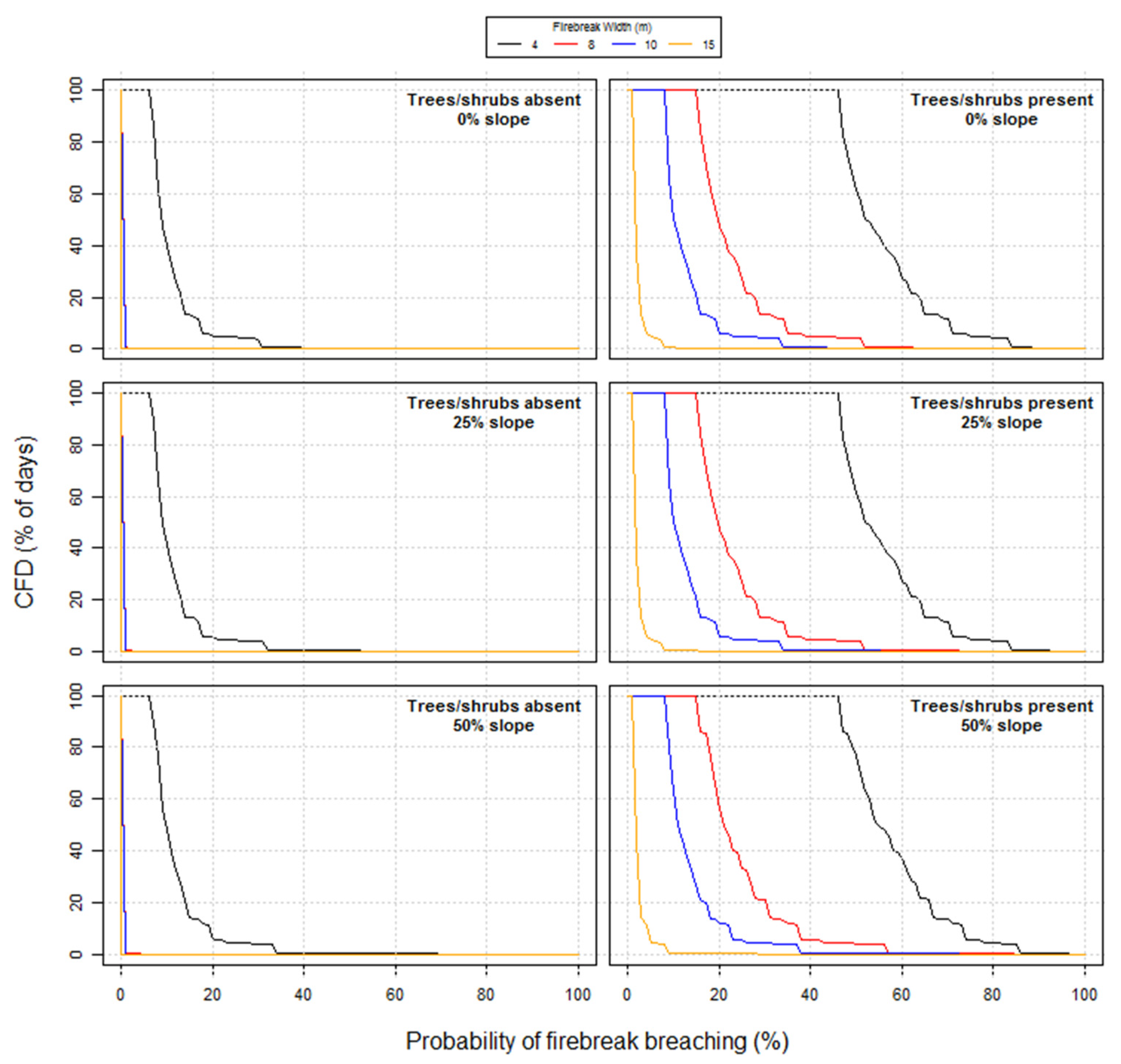
Figure 1. Cumulative frequency distribution (CFD) graphs for the probability of breaching grassland firebreak of different widths where trees and/or shrubs are either absent or present within 20 m of the firebreak according to Wilson’s (1988) models based on the Anderson (1982) Fire Behavior Fuel Model 1—Short grass (0.3 m) for three different slope steepness levels and 23 years of weather records associated with the fire season at Army Garrison Camp Williams, UT. Upslope fire spread is assumed.
Fire 05 00078 g001
Figure 2. Cumulative frequency distribution (CFD) graphs for the probability of breaching grassland firebreak of different widths where trees and/or shrubs are either absent or present within 20 m of the firebreak according to Wilson’s (1988) models based on the Anderson (1982) Fire Behavior Fuel Model 2—Timber (grass and understory) for three different slope steepness levels and 23 years of weather records associated with the fire season at Army Garrison Camp Williams, UT. Upslope fire spread is assumed.
Fire 05 00078 g002
Figure 3. Cumulative frequency distribution (CFD) graphs for four fundamental fire behavior characteristics (AD) based on the Anderson (1982) Fire Behavior Fuel Model 1—Short grass (0.3 m) for three different slope steepness levels and 23 years of weather records associated with the fire season at Army Garrison Camp Williams, UT. Upslope fire spread is assumed.
Fire 05 00078 g003
Figure 4. Cumulative frequency distribution (CFD) graphs for four fundamental fire behavior characteristics (AD) based on the Anderson (1982) Fire Behavior Fuel Model 2—Timber (grass and understory) for three different slope steepness levels and 23 years of weather records associated with the fire season at Army Garrison Camp Williams, UT. Upslope fire spread is assumed.
Fire 05 00078 g004
Figure 5. Cumulative frequency distribution (CFD) graphs for four fundamental fire behavior characteristics (AD) based on the Anderson (1982) Fire Behavior Fuel Model 5—Brush (0.6 m) for three different slope steepness levels and 23 years of weather records associated with the fire season at Army Garrison Camp Williams, UT. Upslope fire spread is assumed.
Fire 05 00078 g005
Figure 6. Cumulative frequency distribution (CFD) graphs for four fundamental fire behavior characteristics (AD) based on the Anderson (1982) Fire Behavior Fuel Model 8—Closed timber litter for three different slope steepness levels and 23 years of weather records associated with the fire season at Army Garrison Camp Williams, UT. Upslope fire spread is assumed.
Fire 05 00078 g006
Figure 7. Cumulative frequency distribution (CFD) graph for the Bruner and Klebenow (1979) scores used for evaluating prescribed fire behavior potential in pinion-juniper woodlands on level terrain during the fire season (March–October) based on 23 years of weather records associated with the fire season at Army Garrison Camp Williams (AGCW), UT. The four curves in bold (i.e., 20, 30.40 and 50%) indicate the typical percent vegetation cover of juniper at AGCW.
Fire 05 00078 g007
Figure 8. Comparison of pre- and post-treatment burn probability at Army Garrison Camp Williams, UT, according to fire weather and fuel moisture conditions associated with the major run of the Machine Gun Fire on 19 September 2010.
Fire 05 00078 g008
Table 1. Inputs required for the four most common fire behavior fuel models (FBFMs) of Anderson [43] utilized in the fire behavior modeling at Army Garrison Camp Williams, UT, along with their associated dead woody fuel moisture time-lag (TL) size classes and live fuel components.
FBFM Number FBFM Name1-h TL10-h TL100-h TLLive
1Short grass (0.3 m)x
2Timber (grass and understory)xxxx
5Brush (0.6 m)xx
8Closed timber litterxxx
Table 2. General rules of thumb associated with the score values in the prescribed burning guide for pinyon-juniper woodlands developed by Bruner and Klebenow [18].
Score ValuePrescribed Fire Behavior Interpretations
<110Burning conditions are such that fires will not carry.
110–125Fires will carry but continual re-torching will be necessary.
125–130Burning conditions are optimal for a self-sustaining fire following ignition, creating “clean burns”.
>130Burning conditions are too hazardous for prescribed burning.
Table 3. Summary of various percentiles for the four simulated fire behavior characteristics by Fire Behavior Fuel Model (FBFM) as per Anderson [43] using BehavePlus for 1400 h daylight saving time for at least 17 years of weather records.
Fire Behavior Fuel ModelPercentilesMaximum
Value
25507590959799
Fireline Intensity (kW m−1)
FBFM 12427131741291133654884488423,424
FBFM 251912883378679310,45512,89521,76653,483
FBFM 51805641980424059517160979217,574
FBFM 8213569104121156163294
Rate of Fire Spread (m min−1)
FBFM 1134592150153223223741
FBFM 26153670104124201368
FBFM 5371531435170131
FBFM 811223345
Flame length (m)
FBFM 112233448
FBFM 2223556812
FBFM 512244557
FBFM 800111111
Maximum Spotting Distance (km)
FBFM 10.50.81.61.82.12.12.64.3
FBFM 20.51.01.62.12.93.14.35.6
FBFM 50.50.81.31.82.62.93.74.7
FBFM 80.50.50.80.81.01.01.01.3
Table 4. Comparison of results for potential fire behavior from pre- and post-treatment scenarios as simulated using the FlamMap system [14].
Fire Behavior CharacteristicAverage PretreatmentAverage
Breaks Only
Average Breaks + Landscape Treatments
2010 Machine Gun Fire
Flame length (m)2.42.12.1
Fireline intensity (kW m−1)956289267938
Rate of spread (m min−1)484745
Burn probability (per pixel)0.19720.02890.0213
2012 Pinion Fire
Flame length (m)1.51.51.2
Fireline intensity (kW m−1)302129872669
Rate of spread (m min−1)161716
Burn probability (per pixel)0.01140.01310.0111
MPMG Range, modified fuels
Flame length (m)2.42.12.1
Fireline intensity (kW m−1)910889157893
Rate of spread (m min−1)464845
Burn probability (per pixel)Cannot be computed for a single point source ignition
Publisher’s Note: MDPI stays neutral with regard to jurisdictional claims in published maps and institutional affiliations.