Article

Impact of Fires on Key Biodiversity Areas (KBAs) and Priority Bird Species for Conservation in Bolivia

by
Oswaldo Maillard
1,2,*,
Sebastian K. Herzog
2,
Rodrigo W. Soria-Auza
2 and
Roberto Vides-Almonacid
1
1
Fundación para la Conservación del Bosque Chiquitano (FCBC), Av. Ibérica calle 6 Oeste 95, Santa Cruz de la Sierra, Santa Cruz, Bolivia
2
Asociación Armonía, Av. Lomas de Arena 400, Casilla, Santa Cruz, Bolivia
*
Author to whom correspondence should be addressed.
Submission received: 25 October 2021 / Revised: 19 December 2021 / Accepted: 30 December 2021 / Published: 4 January 2022
(This article belongs to the Special Issue Effects of Wildfire on Biodiversity)

Abstract

:
Key Biodiversity Areas (KBAs) are sites that contribute significantly to the protection of the planet’s biodiversity. In this study, we evaluated the annual burned areas and the intensity of the fires that affected Bolivia and its 58 KBAs (23.3 million ha) over the last 20 years (2001–2020). In particular, we analyzed the impact of wildfires on the distribution of Bolivian birds at the levels of overall species richness, endemic species and threatened species (Critically Endangered, Endangered, Vulnerable). We found that at the KBA level, the cumulative area of wildfires was 21.6 million ha, while the absolute area impacted was 5.6 million ha. The KBAs most affected by the wildfires are located in the departments of Beni and Santa Cruz; mainly in the KBAs Área Natural de Manejo Integrado San Matías, Oeste del río Mamoré, Este del río Mamoré, Noel Kempff Mercado and Área Natural de Manejo Integrado Otuquis. The wildfires impacted the distribution of 54 threatened species and 15 endemic species in the KBAs. Based on the results of this study, it is a priority to communicate to Bolivian government authorities the importance of KBAs as a strategy for the conservation of the country’s biodiversity and the threats resulting from anthropogenic fires.

1. Introduction

Globally, wildfire regimes are changing, with increasingly longer seasons, mainly induced by climate and human activities [1,2]. Recent estimates obtained from remote sensing reveal that the area affected annually by wildfire ranges from 3.5 to 5 million km2 [3,4]. In South America, a significant increase in burning and wildfire activity has been detected during the period 2001–2018, and a severe wildfire crisis strongly linked to deforestation and forest degradation was recorded in 2019 [4].
Fire is a fundamental component of most of the Earth’s terrestrial ecosystems [5], and the relationship between wildfire and biodiversity is complex [6]. Biodiversity loss is associated with high frequency, large-scale intensity, or absence of fires [7]. The new era of wildfire poses a global challenge in understanding how to maintain biodiversity [8]. Fire is an important ecological factor for numerous species inhabiting some dry ecosystems, such as the Cerrado [9,10,11], but for other ecosystems such as tropical rainforests, wildfire can lead to the destruction or loss of native species and habitats [12]. In both cases, the response of these ecosystems when the seasonality or frequency of burning exceeds their resilience is poorly understood [13].
Large-scale forest wildfires have become the main cause of forest degradation in Bolivia in the last two decades. These wildfires have occurred annually [14], mainly in the lowlands, and have become more frequent and severe in recent years [15]. Although wildfires originate mainly in areas that were recently deforested [16], these spread to protected areas (national and subnational). The subjacent causes for the increase and severity of these are inadequate fire management in the chaqueos (slash-and-burn agriculture to prepare land for planting), mechanized agriculture for commercial purposes, and inadequate pasture management for cattle ranching [17,18,19,20]. Between 2000 and 2015, the absolute area impacted by wildfires in the country was 16 million ha, of which 28% occurred in forested areas [17].
Due to the combination of environmentally destructive agricultural–economic policies [21] and the increasing severity of the droughts [22], wildfires have increased in recent years. The burned area in 2019 was three times larger than in 2018 and exceeded the average of the 2001–2018 period by 51% [4]. These events reopened the debate on the problem of wildfires in Bolivia, the impact they generate on biodiversity, and the potential strategies that could be developed for the effective restoration of impacted ecosystems.
In Bolivia, progress has been made in the development of spatial analyses to determine the impact of wildfires on biodiversity [23,24,25,26]. However, it is necessary to prioritize the evaluation of areas that have been identified as the most important biodiversity areas for species of conservation concern [27]. The Key Biodiversity Areas (KBAs) are a global network of more than 16,000 sites that contribute significantly to the global persistence of biodiversity (http://www.keybiodiversityareas.org/kba-data, accessed on 15 August 2021). These sites were identified using standardized criteria and quantitative thresholds [28]. In Bolivia, there are 58 KBAs, most of which were initially identified as Important Bird Areas (IBAs), and they are distributed across all ecoregions of the country [29,30]. The pressure exerted on these sites by human activities threatens the survival of many species dependent on these areas.
In this study, we analyze the impact that wildfires have had on the geographic patterns of general bird species richness, endemic bird species richness, and threatened bird species richness between 2001 and 2020. The geographic scope of the present study is national, but we place particular emphasis on the impact of the wildfires on all Bolivian KBAs and the bird species that inhabit these areas of high biodiversity importance. We hope that the results presented here can serve as a basis for the development of strategies for immediate conservation and monitoring actions for those KBAs most threatened by wildfires.

2. Materials and Methods
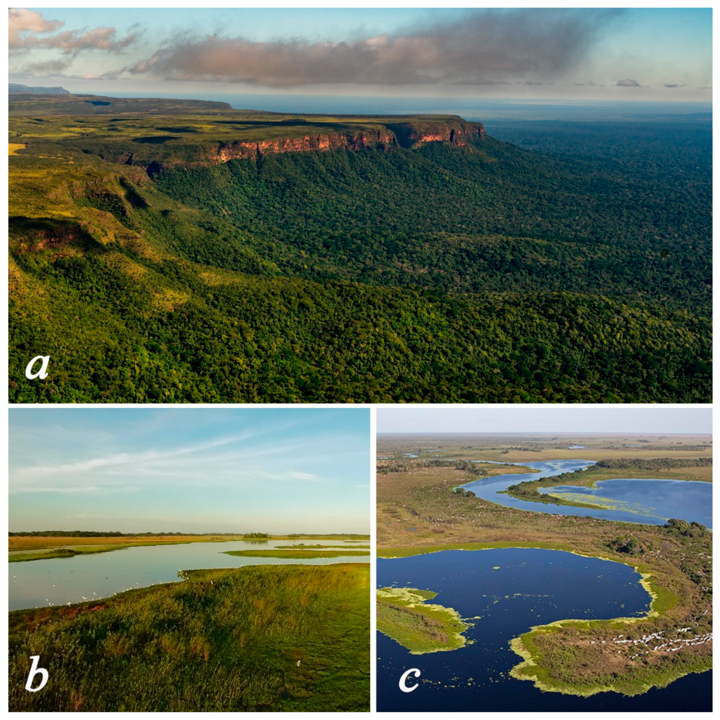
2.1. Study Area

Geomorphologically, two regions can be distinguished in Bolivia. In the west, the Andean region is largely formed by the Cordillera Occidental and the Cordillera Oriental. Both ranges enclose the Andean Altiplano, a comparatively flat region located between 3400 and 4000 m.a.s.l. To the east and north of the Andes are the country’s lowlands (<1000 m.a.s.l.), which occupy more than 60% of the national territory. This region also includes scattered low-altitude mountain ranges, particularly in eastern Bolivia, such as the Huanchaca (Parque Nacional Noel Kempff Mercado) and Sunsás (Área Natural de Manejo Integrado San Matías). According to Ibisch et al. [31], there are 12 ecoregions in Bolivia: Humid Puna, Dry Puna, inter-Andean Dry Valleys, Prepuna, Yungas, Boliviano-Tucumano Forest, Southwest Amazonia, Cerrado, seasonally flooded savanna, Chiquitania, Chaco and Chaco Serrano.
In general, the study area covered the entire country, and the analyses were carried out in all 58 KBAs that are distributed throughout Bolivia (Figure 1). The total area occupied by KBAs in Bolivia is 23,326,168 ha (ranging from 2064 ha to 3,282,376 ha, with an average of 402,175 ha), which represents 21% of the national territory. KBAs are not necessarily protected areas and were identified following 11 criteria that are grouped into five categories that evaluate the elements of threatened biodiversity they harbor, geographically restricted biodiversity (endemism), ecological integrity, biological processes and irreplaceability [28]. The network of these KBAs covers 83% of the total area of Bolivia’s national protected areas [30].

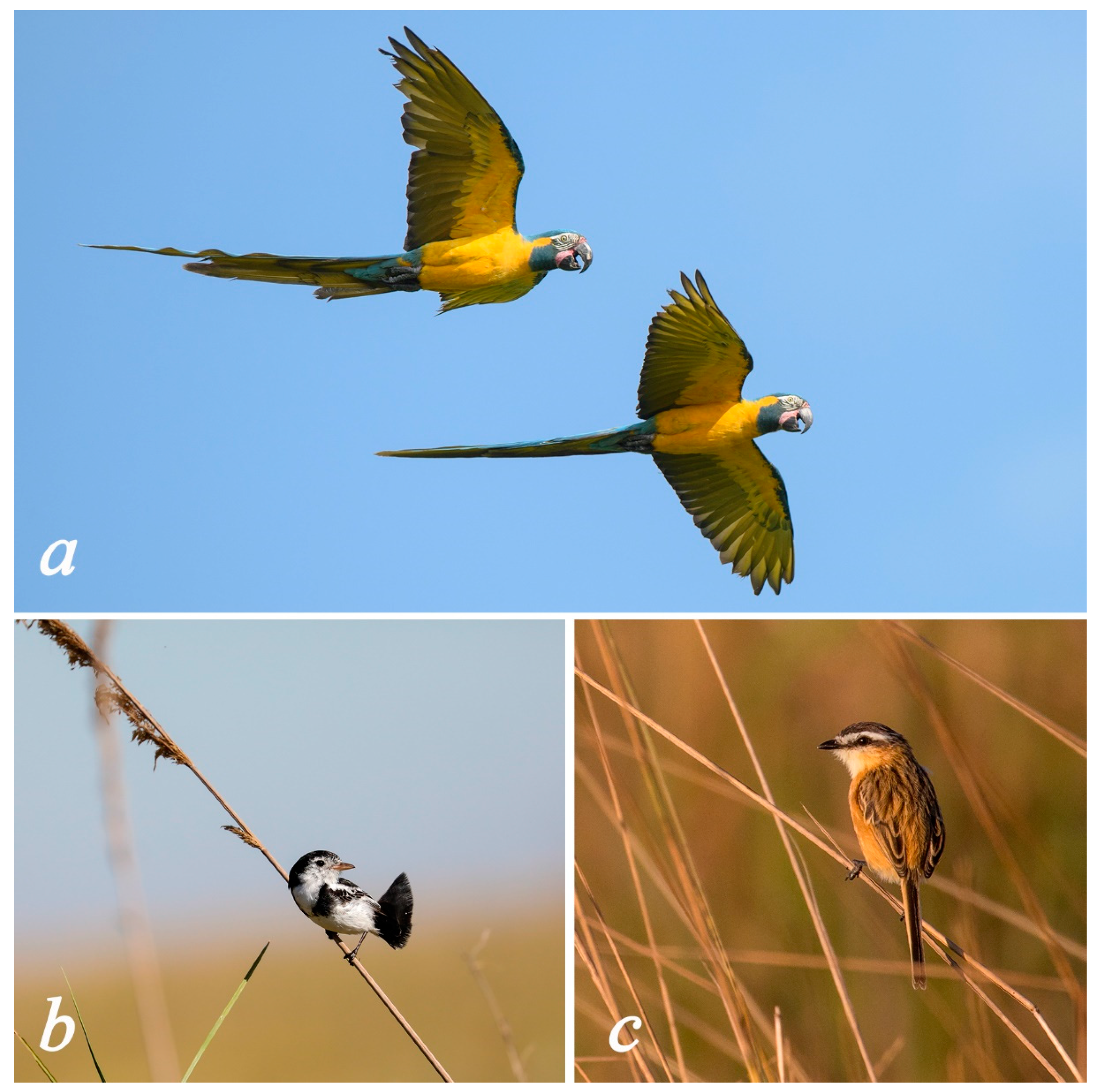
2.2. Species Distribution

In this research, we used birds as indicators to measure the impact of wildfires on biodiversity in Bolivia. The use of birds as indicators of the state of the environment in regional analyses is commonplace because, as a taxonomic group, they are widespread, sensitive to environmental changes, their ecology is well known, and their taxonomy is relatively stable [32]. At present, 1445 bird species have been recorded in Bolivia (https://birdsofbolivia.org/; accessed on 15 August 2021), and the country is the sixth most bird-species-rich country on the planet and the fifth in the Americas [33]. In this study, birds considered priority species for conservation include Bolivia’s 16 endemic bird species and 54 globally threatened species following IUCN criteria (http://datazone.birdlife.org/species/search; accessed on 16 May 2021): Critically Endangered (CR), Endangered (EN), and Vulnerable (VU). Seven of the Bolivian endemics also are globally threatened, so the total number of Bolivian priority bird species is 60. The habitats of many of these priority species are impacted by wildfires (Figure 2). For this analysis, a national classification of threatened species [34] was not considered for two reasons: (1) although the criteria used are different, the system contains the same categories, and approximately 80% of the species are found in the same categories in both systems; (2) the IUCN has a global scope and is formally recognized by most governments and international organizations that allocate funds for the protection of threatened species.
The distribution maps developed for the Birds of Bolivia Field Guide [33] were used in this study. Each species’ map was constructed under a deductive species distribution modeling approach based on expert opinion [35]. This procedure reduced the overestimation of the resulting maps (false-positive errors). The data used for the development of the maps were extracted from Asociación Armonía’s distributional database for Bolivian birds, which contains >120,000 occurrence records from >1400 georeferenced localities [35]. Each map was developed based on occurrence records in vegetation types [36], ecoregions [31] and the known or expected elevational range, using NASA’s Shuttle Radar Topography Mission (SRTM) digital elevation model of 90 m (0.81 ha) to remove grid cells above and below the known or expected upper or lower elevation limit, respectively [35].
Individual distribution maps of each species were processed with the help of the Cell Statistics tool of ArcMap to construct maps of total species richness, endemic species richness and threatened species richness. Each species’ map was then constructed at a spatial resolution of 1′ × 1′ latitude-longitude grid cells (ca. 1.86 × 1.86 km). For the analysis of endemic species, Coppery Thorntail (Discosura letitiae) was excluded from the list since the distribution of this species is unknown, and it is probably already extinct, as it is known only from skins that were collected in the 19th century [37]. In the case of threatened species, distribution maps were not prepared for Black-bellied Thorntail (Lophornis gouldii), because the single historical record is unreliable, and Lemon-browed Flycatcher (Conopias cinchoneti), because the species has been reported only from one observation of a single individual each at only two localities [33], which is insufficient for the preparation of a geographic distribution map of this species in Bolivia.

2.3. Impact of Wildfires

To determine the area impacted by wildfires in Bolivia, we used the monthly product MCD64A1 ver. 6 from the combination of Terra and Aqua (MODIS) satellites, with a spatial resolution of 500 m (https://lpdaac.usgs.gov/products/mcd64a1v006, accessed on 15 February 2021). This product is generated from an automated algorithm that detects rapid patterns of changes in surface reflectivity time-series detected by MODIS sensors [3]. In the cloud computing platform Google Earth Engine (GEE [38]), a script was developed to generate and download annual cumulative images of the time series from 2001 to 2020. Subsequently, the burned areas were cross-referenced with the KBAs, and the area by year and frequency was quantified. In this study, we report the accumulated burned area and the absolute burned area. The first is the total for all years, while the absolute burned area is the annual quantification.
We assessed the impacts of wildfires on Bolivian ecosystems and KBAs, using the MODIS Land Cover Type Product (MCD12Q1.006, https://lpdaac.usgs.gov/products/mcd12q1v006, accessed on 1 December 2021), a series of global land cover maps with yearly intervals and 500 m spatial resolution from 2001 to 2019. We downloaded the University of Maryland (UMD) classification (Type 2) with the help of the GEE platform and merged the 15 land cover types into 7 categories: water bodies, forests, shrublands, savannas, grasslands, croplands, and barren. We used the fire scars and cross-referenced them with a previous year of the cover type map to obtain the annual percentage impact values (2002–2020).

2.4. Wildfire Intensity

Fire activity can be quantified by obtaining the Fire Radiative Power (FRP [39,40]), which describes the rate of radiative energy release from wildfires when they are active. FRP allows distinguishing between fires of different intensities, which is useful for estimating fire risks. The FRP data are in units of Megawatts (MW) and were obtained from the MODIS Collection 6.1 product (1 km pixel resolution), from the FIRMS (https://firms.modaps.eosdis.nasa.gov, accessed on 25 June 2021), from the Terra and Aqua satellites, for the period 2001–2020 (20 years). Subsequently, an interpolation was performed using the inverse distance weighted distance (IDW) technique in ArcMap. Based on the classification proposed by Ichoku et al. [41], the interpolation results were grouped into 5 categories related to fire intensity: (1) <100 MW; (2) 100–499 MW; (3) 500–999 MW; (4) 1000–1499 MW and (5) ≥1500 MW.

2.5. Statistical Analysis

The spatial autocorrelation or spatial dependence of the geographic pattern of the annual wildfire area (2001–2020) was analyzed with the global Moran’s I index through the Spatial Autocorrelation tool of ArcMap. A positive spatial autocorrelation indicates that fires tend to cluster spatially (Moran’s I values greater than zero), while a negative spatial autocorrelation indicates a tendency to dispersion (Moran’s I values less than zero). In addition, we calculated fire frequencies in KBAs and distribution for priority bird species in ranges of annual occurrence events (1, 2–4, 5–7, 8–10, >10).

3. Results

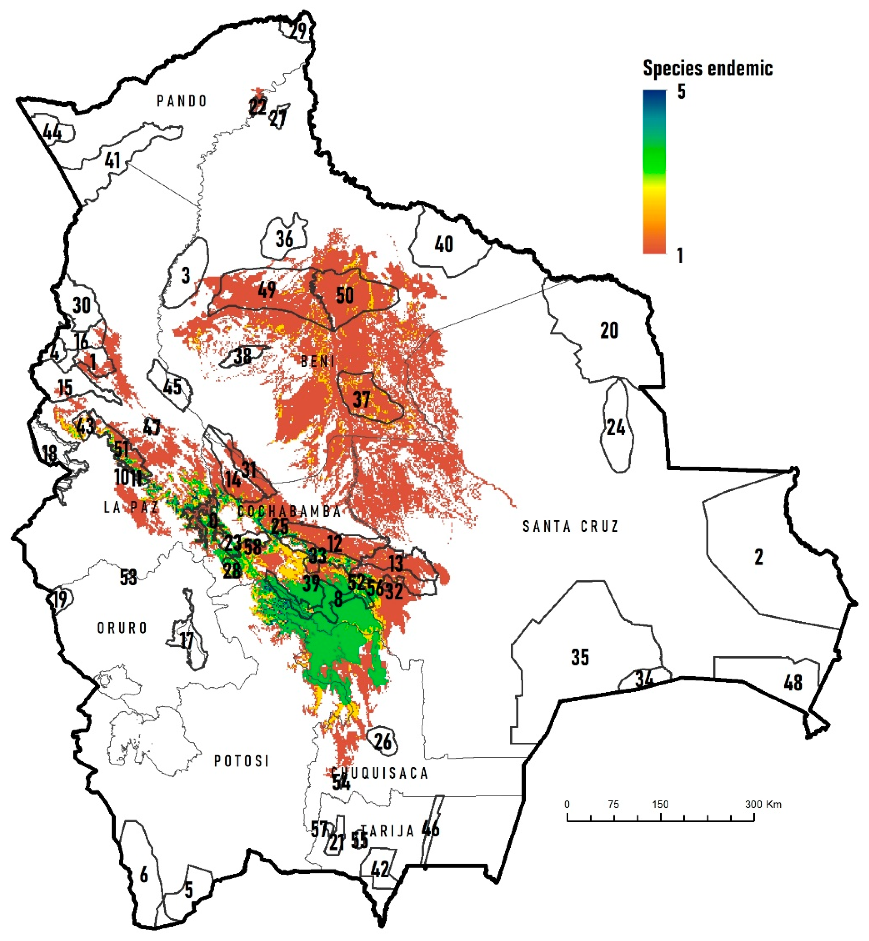
3.1. Biodiversity in the KBAs

The pattern of total bird species richness in Bolivia is characterized by strong latitudinal and altitudinal gradients. Species density (number of species per 1′ × 1′ pixel) peaks in the northern Bolivian Amazon (Pando department) and in the humid foothill and lower montane Yungas forests of the department of La Paz (Figure 3). In the lowlands, species density moderately decreases southward and is lowest in parts of the Chaco and Chiquitanía ecoregions. The altitudinal decrease in species density is steep and particularly low in the western Altiplano and the Cordillera Occidental. The KBAs with the highest local species density (pixels) are Tahuamanu (474 species), Yungas Inferiores de Madidi (464 species), Reserva Nacional Amazónica Manuripi (464 species), Federico Román (463 species) and Yungas Inferiores de Pilón Lajas (450 species) (Figure 3, Table 1).
The geographic pattern of threatened bird species richness (Critically Endangered, Endangered, Vulnerable) changes in relation to the species richness map (compare Figure 3 and Figure 4). The highest species richness of threatened birds is found in the Amazonian rainforest area of eastern Bolivia and in the Yungas (especially in the department of La Paz). The KBAs with the highest richness of threatened species were Noel Kempff Mercado (KBA 20) with 12 species, the Yungas Superiores de Apolobamba (KBA 15) and Yungas Inferiores de Madidi (KBA 30), both with 11 species. They are followed by the Yungas Inferiores de Isiboro-Sécure (KBA 31), Yungas Superiores de Madidi (KBA 16) and Reserva de Inmovilización de Iténez (KBA 40) with 10 species each (Figure 4, Table 1).
The areas with the highest species richness of endemic birds by pixel are located in the inter-Andean Dry Valleys, Yungas and small sectors of the Humid Puna of the department of La Paz (Figure 5). The KBAs with the highest richness of endemic species/pixel are the Upper Yungas of Carrasco (KBA 33), Caine and Mizque River Basins (KBA 8), the Upper Yungas of Amboró (KBA 32) and Cuenca Cotacajes (KBA 7) with 5 species, followed by Yungas inferiores de Carrasco (KBA 12), Yungas Superiores de Mosetenes y Cocapata (KBA 14), Cristal Mayu y alrededores (KBA 25), and Vertiente Sur del Parque Nacional Tunari (KBA 23), with 4 species each (Figure 5, Table 1).

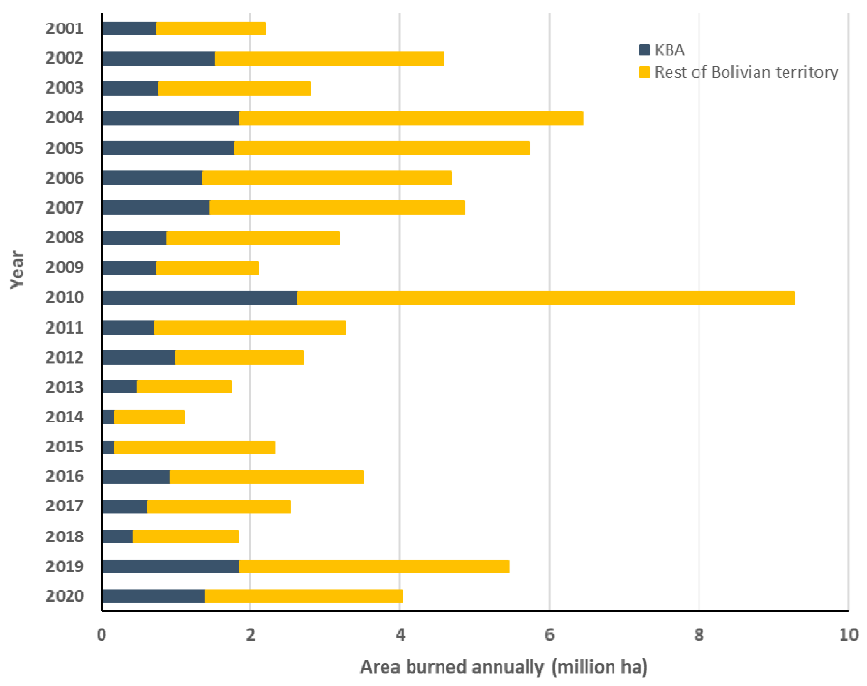
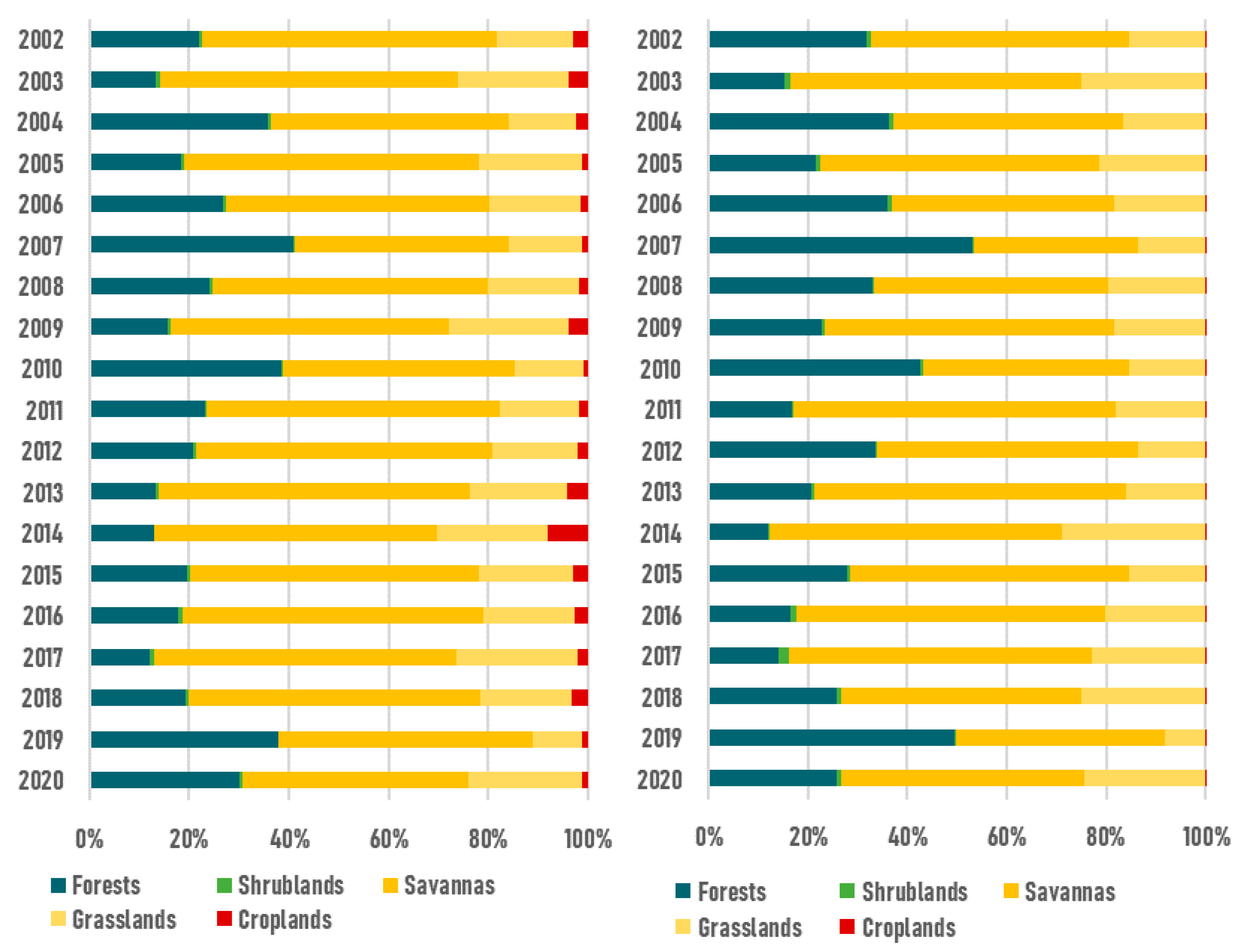
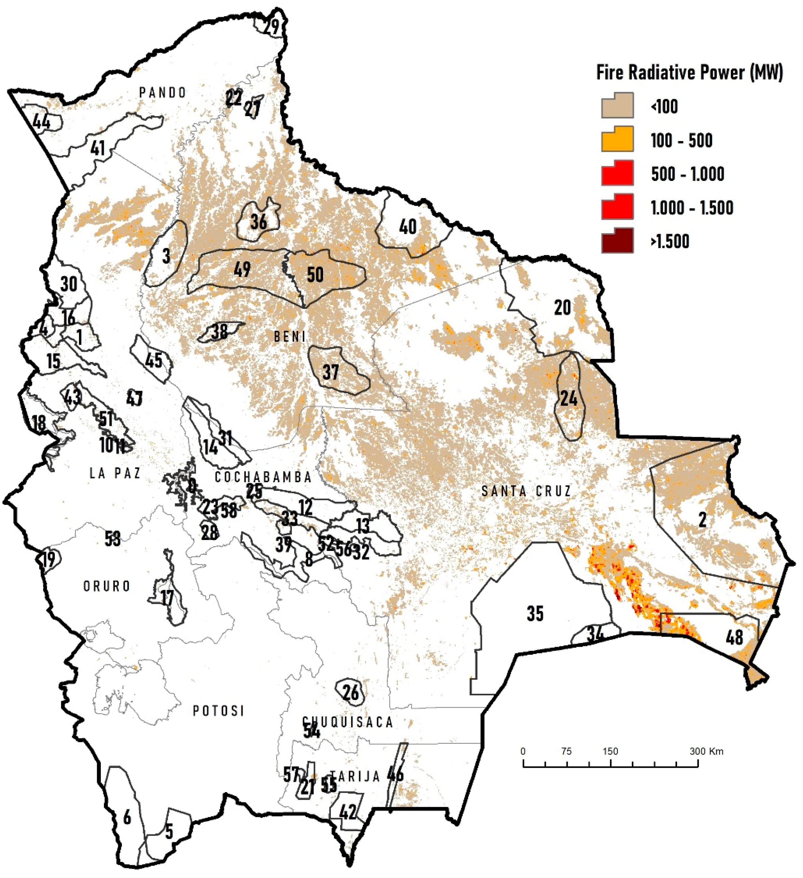
3.2. Impact of Wildfires on the KBAs

At the national level, the cumulative area of wildfires in the period 2001–2020 was 74.3 million ha, while the absolute area was 23.6 million ha (21.5% of the national territory). These fires occurred mainly in the lowlands, and the most extensive burnt areas were reported in 2010 (9.2 million ha), 2004 (6.4 million ha), 2005 (5.7 million ha), and 2019 (5.4 million ha) (Figure 6). Moran’s I index was significant and positive for all years, except 2011 and 2019 (Table 2).
At the KBA level, the cumulative area of wildfires was 21.6 million ha (2001–2020), while the absolute area impacted was 5.6 million ha, representing 24.5% of the KBA. These results indicate that 24.5% of the KBAs were burned at least once during the study period. The years with the largest wildfire-impacted areas within the KBAs were 2010 (2.6 million ha), 2019 (1.8 million ha), 2004 (1.8 million ha), and 2005 (1 million ha) (Figure 6).
The KBAs most affected by wildfires in terms of the number of hectares are located in the departments of Beni and Santa Cruz (Figure 7), mainly in the Área Natural de Manejo Integrado San Matías (1.7 million ha), Oeste del río Mamoré (778 thousand ha), Este del río Mamoré (652 thousand ha), Noel Kempff Mercado (459 thousand ha) and Área Natural de Manejo Integrado Otuquis (395 thousand ha) (Table A1). However, the KBAs proportionally more affected were Este del río Mamoré (85.2%), Alto Paraguá (74.4%), Loreto (71.5%), Oeste del río Mamoré (70.6%) and Laguna Rogaguado y Ginebra (53.8%) (Table A1).
In terms of frequency at the national level, the occurrence of wildfires was mainly recorded between one year (36.6%) and two to four years (39.5%). At the KBA level, 15 sites were impacted by wildfire on at least one year. Another 17 KBAs recorded a series of wildfires between two to four years, four KBAs evidenced fire occurrences between five to seven years, one KBA between eight to ten years, and the other 13 KBAs with wildfires for more than ten years (Figure 8, Table A1). The highest frequency of burns (>10 years) was recorded in the Área Natural de Manejo Integrado Otuquis (23%), Oeste del Río Mamoré (11.7%), Cerrado de Riberalta (8.3%) and Laguna Rogaguado y Ginebra (7.6%) (Figure 7, Table A1).
Savannas, which are located in the Bolivian lowlands (Cerrado, Llanos de Moxos, Pantanal), are proportionally the most affected ecosystems. Between 42% and 62% of their surface is annually burnt (55% mean). These ecosystems are also the most affected ones within the KBAs (33% to 65%, with a mean of 52%), while forests are affected to a lesser degree (12% to 53%, with an average of 28%) (Figure 9).

3.3. Impact of Wildfires on Biodiversity

The fires recorded in the period 2001–2020 affected the entire bird richness within the KBAs (5.6 million ha). Of the 96.1 million ha over which the 54 threatened bird species are distributed, 22 million ha were affected by the wildfires, 5 million ha of which were found within KBAs. For the threatened species, most of this area affected by fire (1.4 million ha) was burned between one and five times during the study period. In the case of the 15 endemic bird species, which are a subset of the threatened species, 5.4 million ha were affected by wildfire, with 1.6 million ha found within 22 KBAs; 90% of this affected area was burned only once, and the remaining 10% burned twice (between 2001 and 2020).

3.4. Impact of Wildfires on the Distribution of Priority Species

The species of conservation concern whose distribution areas were most affected by wildfires during the period 2001–2020 mainly inhabit seasonally flooded savanna, Cerrado and Pantanal. These species were Cock-tailed Tyrant (Alectrurus tricolor, VU), Black-masked Finch (Coryphaspiza melanotis, VU), Sharp-tailed Tyrant (Culicivora caudacuta, VU), Rufous-faced Crake (Laterallus xenopterus, VU), Blue-throated Macaw (Ara glaucogularis, CR), Hyacinth Macaw (Anodorhynchus hyacinthinus, VU), Great-billed Seed-Finch (Sporophila maximiliani, EN), Campo Miner (Geositta poeciloptera, VU), Black-and-tawny Seedeater (Sporophila nigrorufa, VU) and White-winged Nightjar (Eleothreptus candicans, VU). The percentage of the distributional ranges of these species affected by wildfire ranged from 58% to 83% (Table A2). The percentage of distributional ranges of these species within the KBAs was variable, ranging from very light impact (E. candicans) to very severe (L. xenopterus, 91%).
With respect to forest-associated bird species, Unicolored Thrush (Turdus haplochrous, endemic to Bolivia) and Bare-faced Curassow (Crax fasciolata, VU), whose habitats are gallery and varzea forests for the former and Amazonian rainforests of eastern Bolivia and Chiquitano dry forest for the latter, were also significantly affected by wildfires during the time period analyzed (40% and 32%, respectively).

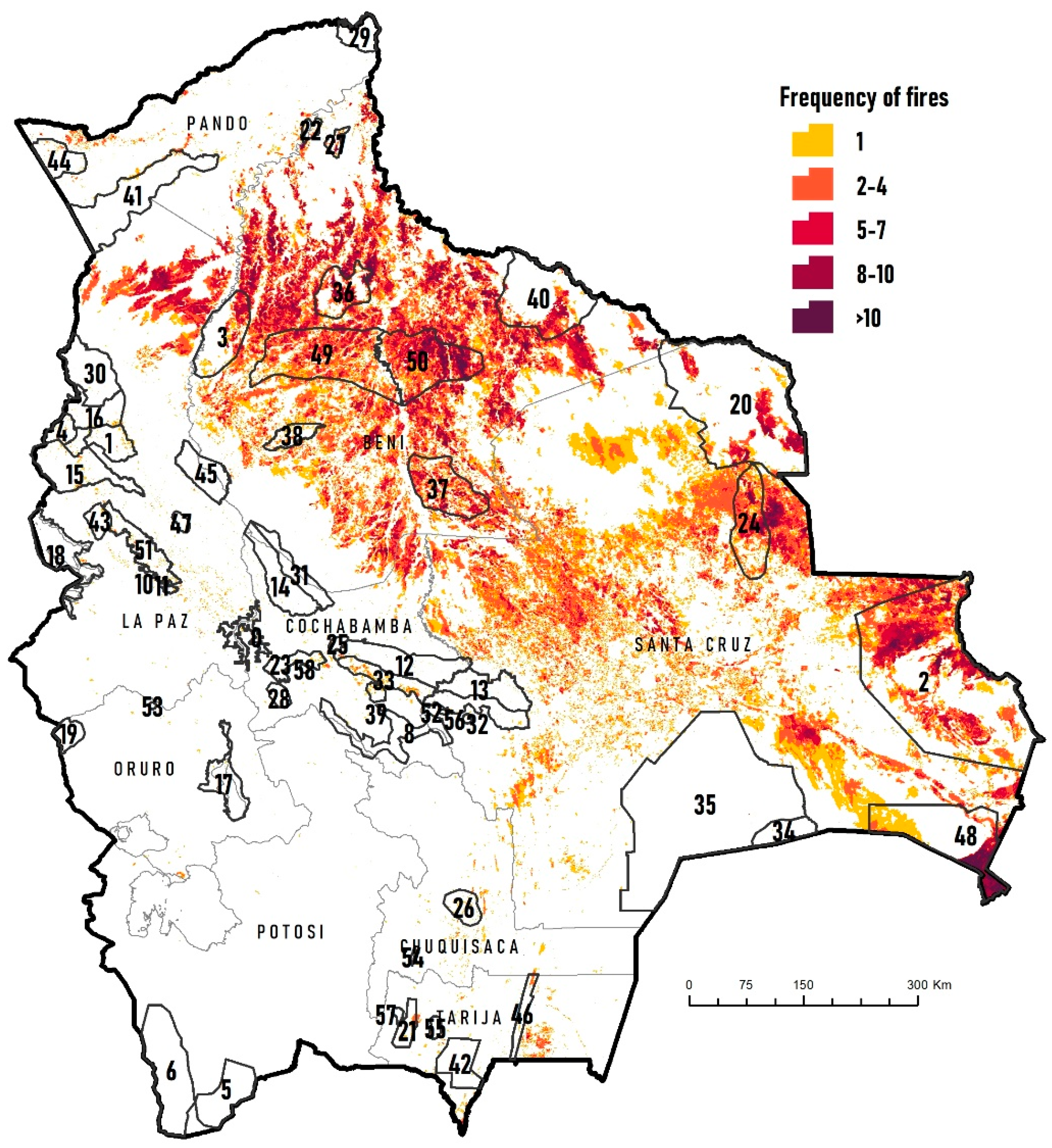
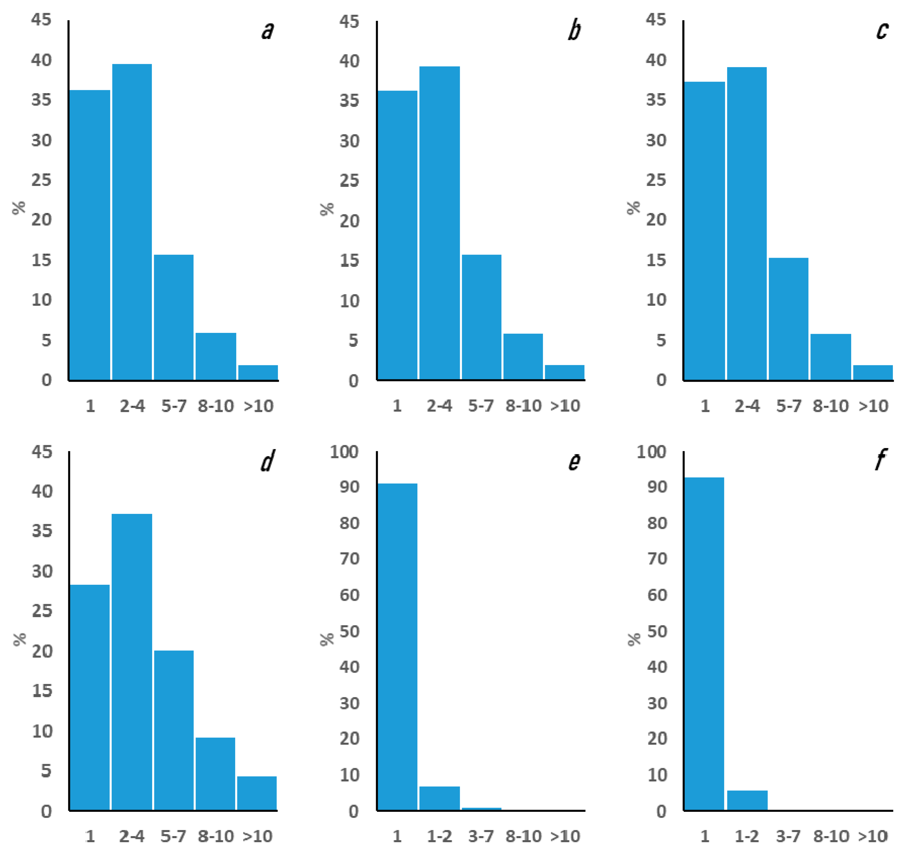
3.5. Wildfire Intensity

The values obtained with the FRP interpolation for the whole of Bolivia indicate that historically (2001–2020), the highest percentage of intensities were concentrated in category one (<100 MW) with 91.2% (Figure 10). However, in focal areas, wildfires with high intensities have been recorded, especially in the southern area of the country, where wildfires were recorded releasing extremely high amounts of energy that fall into category five (>1500 MW), reaching up to 11,551 MW in 2019. At the KBA level, excluding outliers, annual average values range between 29 MW and 43 MW, with the highest intensity recorded in the Área Natural de Manejo Integrado Otuquis.

4. Discussion

The patterns of bird species richness in Bolivia are consistent with the results found by Herzog et al. [42], in the sense that the areas with the highest concentration of species are located in the Amazonia and mountain humid forest (Yungas) regions. The highest concentration of threatened species is found in the Yungas of La Paz and in the northeastern region of the department of Santa Cruz, where the transition from Amazonian rainforest to Chiquitano dry forest takes place. These regions should be prioritized for the establishment of effective protected areas. The Bajo Paraguá region (Chiquitano dry forest) that lies to the west of the KBA Parque Nacional Noel Kempff Mercado is a region that is experiencing very high levels of human pressure. Fortunately, a municipal protected area was declared in this area in 2021 to address increasing deforestation pressure and the construction of a national highway [43].
The geographic pattern of endemic species richness in Bolivia indicates that the existing KBAs in the western Andean region of the country, especially in the department of La Paz, do not coincide with the geographic distributions of these species. This suggests that it is necessary to evaluate the location and extent of some KBA in this region of Bolivia.
Just under a half of the KBAs (44%) are found within national protected areas, and six (12%) overlap [30]. In principle, this implies that at least part of the KBA’s protection should be guaranteed by the state. However, the protected area’s capacities to safeguard biodiversity within their territories needs to be improved significantly for at least three protected areas, where over 2.5 million ha were burnt at least once between 2001 and 2020 (KBAs San Matías, Otuquis and Noel Kempff Mercado). It is also important to highlight that most wildfires take place in the Bolivian lowlands, where the geographical overlapping between KBAs and protected areas is smaller compared with the Andean region of Bolivia. Finally, ten KBAs (5.1 million ha) do not overlap with any national protected area and are among the most vulnerable ones to wildfires. The protection and proper management of all KBAs can offer a major opportunity to combat biodiversity loss [44].
All KBAs are a priority for conservation due to their unique biodiversity characteristics [30]. However, there are not enough economic and human resources to effectively protect all KBAs, so it is necessary to prioritize them based on their biological value, vulnerability, and other social–economic criteria. Yepez et al. [45] carried out prioritization of the IBAs (Important Bird Areas) in the Amazonia region and determined that 9 of the 13 IBAs in Bolivia are at a critical priority level. For most of these, Soria-Auza and Hennessey [29] identified fire-associated activities among the pressures over these IBAs in Bolivia (including annual burns for pasture replacement, out-of-control grassland burns, grassland burns, burns for the renovation of cultivated areas, and arson). The only known study on the historical incidence of wildfires in IBAs was mentioned by Maillard et al. [30]. These authors reported the highest concentration of fires to be located in San Matías (KBA 2). The results obtained in our study can serve, together with other environmental and socioeconomic variables, as a basis for updating a national prioritization list of KBAs.
Wildfires are more frequent and widespread in the Bolivian lowlands, and, consequently, their impacts are also far more extensive in the KBAs located in this part of the country. On the other hand, wildfires are less frequent in the Bolivian Andes, and therefore their impact on Andean KBAs are also less extensive. However, a much more detailed analysis needs to be conducted for range-restricted bird species, or birds that have very local and patchy distributions, whose key habitats (e.g., Polylepis forests and high Andean scrublands) are frequently affected by uncontrolled wildfires (e.g., Poospiza garleppi).
Controlled burns have been the most frequent agriculture practice to clear crops areas or renew pastures for many years [16,46]. These agriculture activities take place mostly between July and October [15,17,20]. However, strategies used by farmers to control burns are not effective, and very frequently, burns initiate large-scale wildfires that affect millions of hectares every year [15,17,19,22]. These are causing a series of ecological, economic and social problems [44]. The scenario is worrisome, especially for the Chiquitano dry forests, where wildfires have been more frequent in recent years. Devisscher et al. [47] simulated possible future risk scenarios for the Chiquitano forest and estimated that until 2025, the probability of increased wildfire risk will be approximately up to 1.8 times more than the estimates for 2010.
For most dry ecosystems, fire is an important ecological force that plays a role in maintaining biodiversity [48]. Generally, fire has beneficial effects for some species but detrimental effects for others [8,9,12,49,50,51]. Most vertebrates are able to escape from wildfires, but mortality rates due to starvation or predation while wandering around until new territories are established increase [51,52]. Loss of habitat, territories, and food [49] provoked by fire might even become a driving force for the local extinction of some species [53]. Species whose main habitat are forests are especially vulnerable, as these are less abundant and more sensitive to disturbance and habitat-specialists [54,55]. In Bolivia, very few studies have examined the impacts of fires on vertebrates. Some investigations carried out in the Chiquitano forest demonstrated that some groups (e.g., small mammals) increase in abundance or even species richness, while abundance and richness for other groups (e.g., birds) decrease [54,56]. The dry and humid forests in the north of the Santa Cruz department changed in structure and composition of tree species as a response to wildfires. These changes are related to plant species-specific abilities to survive and regenerate after wildfires [47,57,58,59,60,61]. All in all, it is evident that visible changes in habitat take place after wildfires affect forests, and it is still poorly understood whether forest structure and composition might return to its previous state (and how long might this process take). This raises the question of how IUCN vulnerable-to-extinction bird species such as Tinamus tao, Crax fasciolata, Patagioenas subvinacea and Hypocnemis ochrogyna might cope with new habitat conditions/characteristics.
Common sense might lead us to consider that threatened species inhabiting in ecoregions where fire plays a key role in ecosystem dynamics might not be at risk. However, the situation for these species is not straight. It is known that Geositta poeciloptera (also Vulnerable of extinction) also inhabits grasslands regularly burnt [62,63], but the effect that changes in wildlife regimes (i.e., increasing in the frequency of fires) might have over this species remains to be studied. In the case of Ara glaucogularis (Critically Endangered) that inhabits in the Llanos de Moxos, a tropical seasonally flooded savanna that contains small palm forest islands (key for this species), wildfires are key in the ecosystem dynamics of this savanna. However, the frequency of provoked fires during the XXI century is presumably higher than during the XX century and more extensive as well. Therefore, the higher frequency of fires might be affecting the habitat quality for this species or its capacity to recover. Something similar has been documented about the effect of bad cattle-management practices over palm-forest islands regeneration in the Llanos de Moxos [64]. However, it remains to be evaluated the specific role of provoked fires within the whole package of bad cattle-management practices. A similar situation might be expected for Anodorhynchus hyacinthinus (vulnerable to extinction) that in Bolivia inhabits in the Pantanal of San Matías (also a tropical seasonally flooded savanna), Cerrado, Mauritia palm stands and gallery forests.
Monitoring is an essential component of conservation and is necessary to identify threats to biodiversity [65]. Monitoring land surface change has been one of the main uses of remote sensing over the past decades [66], and the multiscale capability of remote sensors makes them particularly suitable for quantifying patterns of variation of wildfire impacts in space and time [67]. However, it is a priority to continue field monitoring of bird populations, as they represent one of the best indicators to assess the state of the environment since it is a group sensitive to environmental changes and therefore useful to measure biodiversity trends [44]. Future research should consider studies of bird populations in the field, in combination with remote sensing analyses, in order to understand how sensitive species respond to wildfire regimes at different temporal and spatial scales. In these analyses, it is important to assess fuel consumption and fire spread patterns, intensity (energy release), severity (ecosystem impact), frequency, and seasonality [5]. These studies can help researchers and policymakers to guide actions in the restoration planning of fire-impacted ecosystems in KBAs.

5. Conclusions

KBAs in Bolivia provides key criteria to protect biodiversity and ecology. One of the greatest challenges to maintaining these KBAs are human-caused fires, which have tended to increase in area, frequency and intensity in recent years. Although fire is an ecological element that in certain landscapes contributes to the maintenance of biodiversity, especially for fire-dependent ecosystems such as the Cerrado savannas, the increase in provoked fires represents one of the greatest threats to ecosystems species of conservation concern (threatened and endemic species). During approximately two decades, wildfires impacted 24.5% of the KBA, mainly in the lowlands of Bolivia (Santa Cruz and Beni departments) and affected significantly the distributional range of several species of conservation concern (e.g., Ara glaucogularis, Anodorhynchus hyacinthinus, Crax globulosa). However, the effect of fires on the population dynamics of these species needs to be researched to have a more complete understanding of the magnitude of the impact that fires have on these species. Satellite monitoring, in combination with field monitoring, could help to understand more about the effects on bird populations and thus guide actions in the restoration planning of fire-impacted ecosystems. The increase in human-caused fires requires an adjustment in Bolivia’s public policies, especially in the land-use regulations currently in force in the country. Based on the results of this study, it is a priority to communicate to Bolivian government authorities the importance of KBAs as a strategy for the conservation of the country’s biodiversity and the threats resulting from anthropogenic fires.

Author Contributions

Conceptualization, O.M., S.K.H., R.W.S.-A. and R.V.-A.; methodology, O.M.; software, O.M.; validation, O.M.; formal analysis, O.M.; investigation, O.M.; resources, O.M.; data curation, O.M.; writing-original draft preparation, O.M.; writing-review and editing, O.M., S.K.H., R.W.S.-A. and R.V.-A.; visualization, O.M.; supervision, S.K.H., R.W.S.-A. and R.V.-A.; funding acquisition, S.K.H. and R.V.-A. All authors have read and agreed to the published version of the manuscript.

Funding

We thank the numerous individuals, institutions and organizations that contributed their unpublished data to Asociación Armonía’s distributional bird database. The development of range maps was made possible by financial support from Fundación Amigos de la Naturaleza through grants from the John D. and Catherine T. MacArthur Foundation (Grant 08-91570-000, GSS) and the Netherlands Embassy; and from the Swiss Development Agency (Agencia Suiza para el Desarrollo y la Cooperación—COSUDE; special thanks to Otto Pfister and Gonzalo Mérida) to Asociación Armonía for the Birds of Bolivia Field Guide project. Previous support for Armonia’s distributional bird database was provided by The Nature Conservancy, NatureServe and WWF Bolivia. The analyses of wildfires in Bolivia have been developed as part of a series of investigations by the FCBC Chiquitano Dry Forest Observatory in the framework of the ECCOS project, funded by the European Union.

Data Availability Statement

Not Applicable.

Acknowledgments

We thank the two anonymous referees for their careful review of our manuscript and for their suggestions. Andrea Markos assisted in the downloading and preparation of the fire scar coverage in the initial stage of the analyses. Furthermore, we are grateful to Paola Cuellar and Carla Pinto for their valuable help.

Conflicts of Interest

The authors declare no conflict of interest.

Appendix A

Table A1. Area and frequency of fires in the KBAs of Bolivia, in the period 2001–2020.
KBA CodeKBA NameArea (ha)Burnt Area 2001–2020 (ha)Burnt Area 2001–2020 (%)Frequency of Fires (% KBA)
12–45–78–10>10
1Apolo193,50313,5017.089.610.4---
2Área Natural de Manejo Integrado San Matías3,282,3761,731,28852.725.339.422.710.12.5
3Bajo Río Beni. Región Tacana485,525161,98433.431.530.525.711.31.0
4Bosque de Polylepis de Madidi103,45632433.188.411.6---
5Lagunas de Agua Dulce de Potosí346,30100.0100----
6Lagunas Salinas de Potosí682,82100.0100----
7Cuenca Cotacajes155,65815611.0100----
8Cuencas de los Ríos Caine y Mizque373,4711500.0100----
9Bosque de Polylepis de Sanja Pampa2064502.4100----
10Bosque de Polylepis de Mina Elba63503255.174.425.6---
11Bosque de Polylepis de Taquesi37992255.988.711.3---
12Yungas Inferiores de Carrasco466,99393002.098.41.6---
13Yungas Inferiores de Amboró329,26140951.286.912.70.4--
14Yungas Superiores de Mosetenes y Cocapata369,38613340.487.212.8---
15Yungas Superiores de Apolobamba474,72418,8434.092.37.7---
16Yungas Superiores de Madidi262,21778073.0100----
17Lago Poopó y Río Laka Jahuira264,65216220.6100----
18Lago Titicaca (Sector Boliviano)421,641750.029.229.228.112.01.5
19Parque Nacional Sajama107,9751000.139.360.7---
20Noel Kempff Mercado2,247,479459,97520.540.139.812.65.32.2
21Reserva Biológica Cordillera de Sama104,92910,97710.597.52.5---
22Cercanías de Riberalta49,74710,26620.627.948.514.95.43.2
23Vertiente Sur del Parque Nacional Tunari140,90670945.0100----
24Alto Paraguá516,552384,18774.497.12.9---
25Cristal Mayu y alrededores32,3122250.729.734.714.213.08.3
26Azurduy147,55293266.3100----
27Cerrado de Riberalta55,09917,08031.0100----
28Cerro Q’ueñwa Sandora63,749750.1100----
29Federico Román173,67416290.9100----
30Yungas Inferiores de Madidi405,75612000.397.62.4---
31Yungas Inferiores de Isiboro-Sécure212,0901250.174.325.7---
32Yungas Superiores de Amboró269,64541501.5100----
33Yungas Superiores de Carrasco226,00342,03418.685.513.21.3--
34Palmar de las Islas185,4852000.117.936.223.914.47.6
35Kaa-Iya del Gran Chaco3,231,64218960.124.144.422.27.91.4
36Laguna Rogaguado y Ginebra341,746183,81853.864.333.02.7--
37Loreto512,455366,17471.592.17.9---
38Estación Biológica del Beni135,24833,68924.921.737.826.411.92.3
39Quebrada Mojón44,441567012.872.827.2---
40Reserva de Inmobilización de Iténez909,454239,28826.397.62.4---
41Reserva Nacional Amazónica Manuripi766,35320,8582.788.111.9---
42Reserva Nacional de Flora y Fauna Tariquia254,85629301.173.923.72.4--
43Tacacoma-Quiabaya y Valle Sorata95,87729793.1100----
44Tahuamanu224,08310,4314.753.446.6---
45Yungas Inferiores de Pilón Lajas272,5614250.2100----
46Serranía de Aguaragüe110,84587847.942.712.24.917.323
47Serranía Bella Vista36,5563751.027.149.319.04.30.4
48Área Natural de Manejo Integrado Otuquis972,400395,22840.610.635.827.814.212
49Oeste del río Mamoré1,103,157778,30270.627.149.319.04.3-
50Este del río Mamoré766,016652,38285.210.635.827.814.212
51Cotapata291,14021,1917.3100----
52Comarapa6473-------
53Río Huayllamarca5760-------
54Culpina6091-------
55Río Guadalquivir35,328-------
56Pampa Redonda11,174-------
57Prepuna del área del río San Juan18,073-------
58Cochabamba11,290-------
Table A2. Impact of fires on endemic and threatened bird species in Bolivia and the KBAs. CR = Critically Endangered, EN = Endangered, VU = Vulnerable.
SpeciesEndemicUICN CategoryBolivia (ha)KBA (ha)Burnt Area/Bolivia (ha)Burnt Area/KBA (ha)Burnt Area/Bolivia (%)Burnt Area/KBA (%)
Tinamus tao VU25,259,8725,916,6502,799,725308,32511.15.2
Tinamus osgoodi VU158,567140,981287526751.81.9
Nothoprocta taczanowskii VU114,06178,74214,57511,25012.814.3
Crax globulosa EN818,032320,374128,87536,35015.811.3
Crax fasciolata VU25,001,9325,659,0897,980,4251,454,72531.925.7
Pauxi unicornisXCR974,109743,22010,32548501.10.7
Phoenicoparrus andinus VU685,870384,107197515500.30.4
Rollandia microptera EN597,987537,810155015000.30.3
Patagioenas subvinacea VU31,754,3175,809,4455,474,875457,29217.27.9
Neomorphus geoffroyi VU6,614,7282,398,584182,75059,5752.82.5
Eleothreptus candicans VU219,799232129,225058.80.0
Aglaeactis pamelaX 976,049218,89367,87536,0007.016.4
Psophia viridis VU26,61916,7402752001.01.2
Laterallus xenopterus VU623,010180,166471,300163,32575.690.7
Agamia agami VU18,050,7174,494,5732,020,150346,35011.27.7
Vultur gryphus VU24,467,5783,566,639647,525121,5492.63.4
Spizaetus isidori EN6,101,5482,418,046173,05752,3992.82.2
Buteogallus coronatus EN27,146,9277,649,74210,591,5252,790,42539.036.5
Ramphastos culminatus VU30,316,4496,721,2453,227,174323,89410.64.8
Capito dayi VU2,707,6141,553,855322,225116,97511.97.5
Touit huetii VU2,853,776608,629385,65039,40013.56.5
Myiopsitta luchsiX 2,403,318363,26036004750.10.1
Amazona tucumana VU2,315,790216,69694,41489724.14.1
Pyrrhura perlata VU3,940,7221,750,782621,375119,75015.86.8
Pyrrhura snethlageae VU8,847,5182,639,0751,531,900263,22517.310.0
Anodorhynchus hyacinthinus VU1,136,000949,652836,650726,60073.676.5
Primolius couloni VU10,607,4731,409,521824,77575,1257.85.3
Ara glaucogularisXCR5,044,0301,903,4583,731,3001,493,32574.078.5
Ara rubrogenysXCR2,581,914392,61610,67539750.41.0
Ara militaris VU7,620,8892,553,029185,66841,2862.41.6
Euchrepomis sharpei EN1,871,754812,66528,14617,7471.52.2
Hypocnemis ochrogyna VU8,006,1152,381,6601,485,550208,05018.68.7
Hylopezus auricularisXVU49,80825,0505050317510.112.7
Geositta poeciloptera VU323,179320,467209,825208,77564.965.1
Cinclodes aricomae CR307,113141,39232,02515,70010.411.1
Asthenes berlepschiX 95,06331,942267512502.83.9
Asthenes hartertiX 548,323158,62944,40023,2008.114.6
Asthenes helleri VU146,117107,65618,57514,85012.713.8
Cranioleuca henricaeXVU180,62947,95817257001.01.5
Cranioleuca curtata VU2,692,1721,163,41223,02110,1020.90.9
Phibalura bolivianaXEN420,463228,05718,65014,7004.46.4
Lipaugus uropygialis VU1,007,525443,04931,05310,2053.12.3
Cnipodectes superrufus VU110,99720,4612,8253502.51.7
Zimmerius cinereicapilla VU550,336128,57323002000.40.2
Phyllomyias weedeni VU1,245,022432,825609412320.50.3
Anairetes alpinus EN295,573195,26031,58024,83210.712.7
Culicivora caudacuta VU6,443,0131,792,3945,086,2251,398,47578.978.0
Alectrurus tricolor VU4,531,9741,335,3633,760,3001,128,37583.084.5
Agriornis albicauda VU7,009,968338,22149,73420,1170.75.9
Cinclus schulzii VU451,41446,92923,42541505.28.8
Turdus haplochrousX 4,489,831302,3901,800,100131,00040.143.3
Atlapetes rufinuchaX 2,525,452836,95275,27525,2753.03.0
Oreopsar bolivianusX 3,128,908443,207762528250.20.6
Diglossa carbonariaX 1,580,198270,37962,52535,8254.013.2
Sporophila nigrorufa VU525,873336,433319,975196,62560.858.4
Sporophila maximiliani EN9,974,0392,583,5376,923,9252,004,72569.477.6
Coryphaspiza melanotis VU4,663,4501,103,5583,828,675921,70082.183.5
Poospiza garleppiXEN647,396100,09918,50071502.97.1
Poospiza baeri VU78,81014,824292516753.711.3
Stilpnia argyrofenges VU2,987,0031,546,49671,65230,0562.41.9

References

  1. Jolly, W.M.; Cochrane, M.A.; Freeborn, P.H.; Holden, Z.A.; Brown, T.J.; Williamson, G.J.; Bowman, D.M. Climate-induced variations in global wildfire danger from 1979 to 2013. Nat. Commun. 2015, 6, 7537. [Google Scholar] [CrossRef]
  2. Pausas, J.G.; Keeley, J.E. Wildfires and global change. Front. Ecol. Environ. 2021, 19, 387–395. [Google Scholar] [CrossRef]
  3. Giglio, L.; Boschetti, L.; Roy, D.P.; Humber, M.L.; Justice, C.O. The Collection 6 MODIS burned area mapping algorithm and product. Remote Sens. Environ. 2018, 217, 72–85. [Google Scholar] [CrossRef]
  4. Lizundia-Loiola, J.; Pettinari, M.L.; Chuvieco, E. Temporal Anomalies in Burned Area Trends: Satellite Estimations of the Amazonian 2019 Fire Crisis. Remote Sens. 2020, 12, 151. [Google Scholar] [CrossRef] [Green Version]
  5. McLauchlan, K.K.; Higuera, P.E.; Miesel, J.; Rogers, B.M.; Schweitzer, J.; Shuman, J.K.; Tepley, A.J.; Varner, J.M.; Veblen, T.T.; Adalsteinsson, S.A.; et al. Fire as a fundamental ecological process: Research advances and frontiers. J. Ecol. 2020, 108, 2047–2069. [Google Scholar] [CrossRef]
  6. Tingley, M.W.; Ruiz-Gutiérrez, V.; Wilkerson, R.L.; Howell, C.A.; Siegel, R.B. Pyrodiversity promotes avian diversity over the decade following forest fire. Proc. R. Soc. B Biol. Sci. 2016, 283, 20161703. [Google Scholar] [CrossRef] [Green Version]
  7. Olsen, P.; Weston, M. Fire and Birds: Fire Management for Biodiversity; Supplement to Wingspan; Birds Australia: Victoria, Australia, 2005; Volume 15. [Google Scholar]
  8. Kelly, L.T.; Giljohann, K.M.; Duane, A.; Aquilué, N.; Archibald, S.; Batllori, E.; Bennett, A.F.; Buckland, S.T.; Canelles, Q.; Clarke, M.F.; et al. Fire and biodiversity in the Anthropocene. Science 2020, 370, eabb0355. [Google Scholar] [CrossRef]
  9. Kelly, L.T.; Brotons, L. Using fire to promote biodiversity. Science 2017, 355, 1264–1265. [Google Scholar] [CrossRef]
  10. Pivello, V.R. Fire Management for Biological Conservation in the Brazilian Cerrado. In Savana and Dry Forests Linking People with Nature; Mistry, J., Berardi, A., Eds.; Ashgate Publishing: Farnham, UK, 2006; pp. 129–154. [Google Scholar]
  11. Wood, J.R.I.; Mamani, F.; Pozo, P.; Soto, D.; Villarroel, D. Libro Rojo de las Plantas de los Cerrados del Oriente Boliviano; Darwin Iniative & Museo de Historia Natural Noel Kempff Mercado: Santa Cruz de la Sierra, Bolivia, 2010; 153p. [Google Scholar]
  12. Myers, R.L. Living with Fire—Sustaining Ecosystems & Livelihoods through Integrated Fire Management; Global Fire Initiative; The Nature Conservancy: Tallahassee, FL, USA, 2006; 36p. [Google Scholar]
  13. Maillard, O.; Anívarro, R.; Vides-Almonacid, R.; Torres, W. Estado de conservación de los ecosistemas de las serranías chiquitanas: Un caso de estudio de la Lista Roja de Ecosistemas de la UICN en Bolivia. Ecología En Bolivia 2018, 53, 128–149. [Google Scholar]
  14. Pinto, C.; Vroomans, V. Chaqueos e Incendios Forestales en Bolivia; Instituto Boliviano de Investigación Forestal: Santa Cruz de la Sierra, Bolivia, 2007. [Google Scholar]
  15. Bilbao, B.; Steil, L.; Urbieta, I.R.; Anderson, L.; Pinto, C.; González, M.E.; Millán, A.; Falleiro, R.M.; Morici, E.; Ibarnegaray, V.; et al. Wildfires. In Adaptation to Climate Change Risks in Ibero-American Countries; Moreno, J.M., Laguna-Defior, C., Barros, V., Calvo Buendía, E., Marengo, J.A., Oswald Spring, U., Eds.; RIOCCADAPT Report; McGraw Hill: New York, NY, USA, 2020; pp. 435–496. [Google Scholar]
  16. Villegas, Z.; Mostacedo, B. Diagnóstico de la Situación Actual Sobre Políticas, Información, Avances y Necesidades Futuras Sobre MRV en Bolivia; CIFOR: Bogor, Indonesia, 2011; 64p. [Google Scholar]
  17. FAN (Fundación Amigos de la Naturaleza). Atlas Socioambiental de las Tierras Bajas y Yungas de Bolivia. Segundaª Edición; Editorial FAN: Santa Cruz de la Sierra, Bolivia, 2016. [Google Scholar]
  18. Devisscher, T.; Boyd, E.; Malhibb, Y. Anticipating future risk in social-ecological systems using fuzzy cognitive mapping: The case of wildfire in the Chiquitania, Bolivia. Ecol. Soc. 2016, 21, 18. [Google Scholar] [CrossRef] [Green Version]
  19. Rodríguez, A. Cartografía multitemporal de quemas e incendios forestales en Bolivia: Detección y validación post-incendio. Ecología En Bolivia 2012, 47, 53–71. [Google Scholar]
  20. TIERRA. Fuego en Santa Cruz. Balance de los Incendios Forestales 2019 y su Relación con La Tenencia de la Tierra; Edición TIERRA: Santa Cruz de la Sierra, Bolivia, 2019. [Google Scholar]
  21. Romero-Muñoz, A.; Jansen, M.; Nuñez, A.M.; Toledo, M.; Almonacid, R.V.; Kuemmerle, T. Fires scorching Bolivia’s Chiquitano forest. Science 2019, 366, 1082. [Google Scholar] [CrossRef]
  22. Maillard, O.; Vides-Almonacid, R.; Flores-Valencia, M.; Coronado, R.; Vogt, P.; Vicente-Serrano, S.M.; Azurduy, H.; Anívarro, R.; Cuellar, R.L. Relationship of Forest Cover Fragmentation and Drought with the Occurrence of Forest Fires in the Department of Santa Cruz, Bolivia. Forests 2020, 11, 910. [Google Scholar] [CrossRef]
  23. Anívarro, R.; Azurduy, H.; Maillard, O.; Markos, A. Diagnóstico por Teledetección de Áreas Quemadas en la Chiquitania; Informe técnico del Observatorio Bosque Seco Chiquitano, Fundación para la Conservación del Bosque Chiquitano: Santa Cruz de la Sierra, Bolivia, 2019; 70p. [Google Scholar]
  24. WCS. Valores de Conservación en Riesgo por la Ocurrencia de Focos de Calor. Boletín 2 Periodo de Análisis Julio-Agosto 2020; WCS: La Paz, Bolivia, 2020. [Google Scholar]
  25. FAN & WCS. Incendios Forestales en Bolivia-Análisis de Impactos de Los Incendios Forestales Sobre Los Valores de Conservación en Bolivia, 2020; Fundación Amigos de la Naturaleza: Santa Cruz de la Sierra, Bolivia, 2021. [Google Scholar]
  26. Pacheco, L.F.; Quispe-Calle, L.C.; Suárez-Guzmán, F.A.; Ocampo, M.; Claure-Herrera, Á.J. Muerte de mamíferos por los incendios de 2019 en la Chiquitania. Ecología En Bolivia 2021, 56, 4–16. [Google Scholar]
  27. Maillard, O.; Angulo, S.; Vides-Almonacid, R.; Rumiz, D.; Vogt, P.; Monroy-Vilchis, O.; Justiniano, H.; Azurduy, H.; Coronado, R.; Venegas, C.; et al. Integridad del paisaje y riesgos de degradación del hábitat del jaguar (Panthera onca) en áreas ganaderas de las tierras bajas de Santa Cruz, Bolivia. Ecología En Bolivia 2020, 55, 94–110. [Google Scholar]
  28. KBA (KBA Standards and Appeals Committee). Guidelines for Using a Global Standard for the Identification of Key Biodiversity Areas; Version 1.1; Prepared by the KBA Standards and Appeals Committee of the IUCN Species Survival Commission and IUCN World Commission on Protected Areas; IUCN KBA Standards and Appeals Committee: Gland, Switzerland, 2020; 206p. [Google Scholar]
  29. Soria Auza, R.W.; Hennessey, A.B. Áreas Importantes para la Conservación de las Aves en Bolivia and Áreas Importantes para la Conservación de las Aves en las Andes Tropicales: Sitios prioritarios para la conservación de la biodiversidad. In BirdLife International and Conservation International; BirdLife Conservation Series No. 14; BirdLife International: Quito, Ecuador, 2005; pp. 57–116. [Google Scholar]
  30. Maillard, Z.; Hennessey, A.B.; Davis, S.E. Bolivia. In Important Bird Areas of the Americas; Devenish, C., Diaz Fernandez, D.F., Clay, R.P., Davidson, I.J., Eds.; BirdLife Conservation Series 16; BirdLife International: Quito, Ecuador, 2010; pp. 91–98. [Google Scholar]
  31. Ibisch, P.L.; Beck, S.G.; Gerkmann, B.; Carretero, A. Ecorregiones y ecosistemas. In Biodiversidad: La Riqueza de Bolivia. Estado de Conocimiento Y Conservación. Ministerio de Desarrollo Sostenible; Ibisch, P.L., Mérida, G., Eds.; Editorial FAN: Santa Cruz de la Sierra, Bolivia, 2003; pp. 47–88. [Google Scholar]
  32. BirdLife International. Important Bird and Biodiversity Areas: A Global Network for Conserving Nature and Benefiting People; BirdLife International: Cambridge, UK, 2014. [Google Scholar]
  33. Herzog, S.K.; Terrill, R.S.; Jahn, A.; Remsen, J.V., Jr.; Maillard, O.; García-Soliz, V.H.; MacLeod, R.; Maccormick, A.; Vidoz, J.Q. Birds of Bolivia—Field Guide; Asociación Armonía, Santa Cruz de la Sierra, Bolivia and Future Generations University: Franklin, TN, USA, 2019; 491p. [Google Scholar]
  34. MAAyA (Ministerio de Medio Ambiente y Agua). Libro Rojo de la Fauna Silvestre de Vertebrados de Bolivia; Ministerio de Medio Ambiente y Agua: La Paz, Bolivia, 2009. [Google Scholar]
  35. Herzog, S.; Maillard, O.; Embert, D.; Caballero, P.; Quiroga, D. Range size estimates of Bolivian endemic bird species revisited: The importance of environmental data and national expert knowledge. J. Ornithol. 2012, 153, 1189–1202. [Google Scholar] [CrossRef]
  36. Navarro, G.; Ferreira, W. Mapa de Vegetación de Bolivia, Esc.1:250,000. Edición Digital; The Nature Conservancy: Santa Cruz de la Sierra, Bolivia, 2007. [Google Scholar]
  37. Züchner, T.; Boesman, P.F.D.; Sharpe, C.J. Coppery Thorntail (Discosura letitiae), version 1.0. In Birds of the World; del Hoyo, J., Elliott, A., Sargatal, J., Christie, D.A., de Juana, E., Eds.; Cornell Lab of Ornithology: Ithaca, NY, USA, 2020. [Google Scholar]
  38. Gorelick, N.; Hancher, M.; Dixon, M.; Ilyushchenko, S.; Thau, D.; Moore, R. Google Earth Engine: Planetary-scale geospatial analysis for everyone. Remote Sens. Environ. 2017, 202, 18–27. [Google Scholar] [CrossRef]
  39. Kaufman, Y.J.; Justice, C.O.; Flynn, L.P.; Kendall, J.D.; Prins, E.M.; Giglio, L.; Ward, D.E.; Menzel, W.P.; Setzer, A.W. Potential global fire monitoring from EOS-MODIS. J. Geophys. Res. 1998, 103, 32215–32238. [Google Scholar] [CrossRef]
  40. Wooster, M.J.; Roberts, G.; Perry, G.L.W.; Kaufman, Y.J. Retrieval of biomass combustion rates and totals from fire radiative power observations: FRP derivation and calibration relationships between biomass consumption and fire radiative energy release. J. Geophys. Res. 2005, 110, D24311. [Google Scholar] [CrossRef]
  41. Ichoku, C.; Giglio, L.; Wooster, M.J.; Remer, L.A. Global characterization of biomass-burning patterns using satellite measurements of fire radiative energy. Remote Sens. Environ. 2008, 112, 2950–2962. [Google Scholar] [CrossRef]
  42. Herzog, S.K.; Soria Auza, R.W.; Bennett Hennessey, A. Patrones ecorregionales de riqueza, endemismo y amenaza de la avifauna boliviana: Prioridades para la planificación ecorregional. Ecología En Bolivia 2005, 40, 27–40. [Google Scholar]
  43. Maillard, O.; Anivarro, R.; Vides-Almonacid, R.; Salinas, J.C. El impacto de la infraestructura vial en ecosistemas de alta fragilidad: El caso de la construcción de una carretera en el norte chiquitano, Bolivia. In Bolivia. Desafíos Socioambientales en Las Tierras Bajas; Inturias, M., Von Stosch, K., Balderlomar, H., Rodriguez, I., Eds.; Instituto de Investigación Científica Social (IICS) de la Universidad Nur: Santa Cruz de la Sierra, Bolivia, 2019; pp. 119–149. [Google Scholar]
  44. Asociación Armonía. Estado de Conservación de Las Aves en Bolivia; Asociación Armonía: Santa Cruz de la Sierra, Bolivia, 2012; 28p. [Google Scholar]
  45. Yépez, I.; Devenish, C.; Clay, R.P. Important Bird Areas in the Amazon Basin; BirdLife International: Quito, Ecuador, 2009. [Google Scholar]
  46. McDaniel, J.; Kennard, D.; Fuentes, A. Smokey the tapir: Traditional fire knowledge and fire prevention campaigns in lowland Bolivia. Soc. Nat. Resour. 2005, 18, 921–931. [Google Scholar] [CrossRef]
  47. Devisscher, T.; Anderson, L.O.; Aragão, L.E.O.C.; Galván, L.; Malhi, L. Increased wildfire risk driven by climate and development interactions in Bolivian Chiquitania, southern Amazonia. PLoS ONE 2016, 11, e0161323. [Google Scholar] [CrossRef] [PubMed] [Green Version]
  48. He, T.; Lamont, B.B.; Pausas, J.G. Fire as a key driver of Earth’s biodiversity. Biol. Rev. Camb. Philos. Soc. 2019, 94, 1983–2010. [Google Scholar] [CrossRef]
  49. Nasi, R.; Dennis, R.; Meijaard, E.; Applegate, G.; Moore, P. Forest fire and biological diversity. Unasylva 2002, 209, 36–40. [Google Scholar]
  50. Pastro, L.A.; Dickman, C.R.; Letnic, M. Burning for biodiversity or burning biodiversity? Prescribed burn vs. wildfire impacts on plants, lizards, and mammals. Ecological Applications 2011, 21, 3238–3253. [Google Scholar] [CrossRef]
  51. Bond, W.J.; Keane, R.E. Fires, Ecological Effects of. Reference Module in Life Sciences; Elsevier: Amsterdam, The Netherlands, 2017. [Google Scholar] [CrossRef]
  52. Cochrane, M.A. Spreading Like Wildfire—Tropical Forest Fires in Latin America and the Caribbean: Prevention, Assessment and Early Warning; United Nations Environment Programme (UNEP): Mexico City, Mexico, 2002. [Google Scholar]
  53. Sodhi, N.S.; Sekercioglu, C.H.; Barlow, J.; Robinson, S.K. Fire and the Conservation of Tropical Birds. In Conservation of Tropical Birds; Sodhi, N.S., Sekercioglu, C.H., Barlow, J., Robinson, S.K., Eds.; Wiley-Blackwell: Cambridge, UK, 2011; pp. 109–125. [Google Scholar]
  54. Barlow, J.; Haugaasen, T.; Peres, C. Effects of ground fires on understorey bird assemblages in Amazonian forests. Biol. Conserv. 2002, 105, 157–169. [Google Scholar] [CrossRef]
  55. Mestre, L.A.; Cochrane, M.A.; Barlow, J. Long-term Changes in Bird Communities after Wildfires in the Central Brazilian Amazon. Biotropica 2013, 45, 480–488. [Google Scholar] [CrossRef]
  56. Fredericksen, N.J.; Fredericksen, T.S. Terrestrial wildlife responses to logging and fire in a Bolivian tropical humid forest. Biodiv. Conserv. 2002, 11, 27–38. [Google Scholar] [CrossRef]
  57. Mostacedo, B.; Fredericksen, T.; Gould, K.; Toledo, M. Comparación de la Respuesta de las Comunidades Vegetales a los Incendios Forestales en los Bosques Tropicales Secos Y Húmedos de Bolivia; Documento Técnico 83/1999; Proyecto de Manejo Forestal Sostenible BOLFOR: Santa Cruz, Bolivia, 1999. [Google Scholar]
  58. Fredericksen, T.S.; Justiniano, M.J.; Mostacedo, B.; Kennard, D.; McDonald, L. Comparative regeneration ecology of three leguminous timber species in a Bolivian tropical dry forest. New For. 2000, 20, 45–64. [Google Scholar] [CrossRef]
  59. Gould, K.A.; Fredericksen, T.S.; Morales, F.; Kennard, D.; Putz, F.E.; Mostacedo, B.; Toldeo, M. Post-fire tree regeneration in lowland Bolivia: Implications for fire management. For. Ecol. Manag. 2002, 185, 225–234. [Google Scholar] [CrossRef]
  60. Kennard, D.K.; Gould, K.; Putz, F.E.; Fredericksen, T.S.; Morales, F. Effect of disturbance intensity on regeneration mechanisms in a tropical dry forest. For. Ecol. Manag. 2002, 162, 197–208. [Google Scholar] [CrossRef] [Green Version]
  61. Veldman, J.W.; Mostacedo, B.; Peña-Claros, M.; Putz, F.E. Selective logging and fire as drivers of alien grass invasion in a Bolivian tropical dry forest. For. Ecol. Manag. 2009, 258, 1643–1649. [Google Scholar] [CrossRef]
  62. Bates, J.M.; Parker, T.A., III; Capparella, A.P.; Davis, T.J. Observations on the campo, cerrado and forest avifaunas of eastern Dpto. Santa Cruz, Bolivia, incluiding 21 species newto the country. Bull. Br. Ornithol. Club 1992, 112, 86–98. [Google Scholar]
  63. Machado, T.L.; Lombardi, V.T.; de Meireles, R.C.; Teixeira, J.P.; Solar, R.R.; Lopes, L.E. Breeding biology of the threatened Campo Miner Geositta poeciloptera (Aves: Scleruridae), a Neotropical grassland specialist. J. Nat. Hist. 2017, 51, 2551–2563. [Google Scholar] [CrossRef]
  64. Hordijk, I.; Meijer, F.; Nissen, E.; Boorsma, T.; Poorter, L. Cattle affect regeneration of the palm species Attalea princeps in a Bolivian forest–savanna mosaic. Biotropica 2019, 51, 28–38. [Google Scholar] [CrossRef] [Green Version]
  65. Jones, J.P.; Asner, G.P.; Butchart, S.H.; Karanth, K.U. The ‘why’, ‘what’ and ‘how’ of monitoring for conservation. In Key Topics in Conservation Biology; MacDonald, D.W., Willis, K.J., Eds.; Wiley-Blackwell: Cambridge, UK, 2013; pp. 327–343. [Google Scholar]
  66. Crowley, M.A.; Cardille, J.A. Remote Sensing’s Recent and Future Contributions to Landscape Ecology. Curr. Landsc. Ecol. Rep. 2020, 5, 45–57. [Google Scholar] [CrossRef]
  67. Pettinari, M.L.; Chuvieco, E. Fire Danger Observed from Space. Surv. Geophys. 2020, 41, 1437–1459. [Google Scholar] [CrossRef]
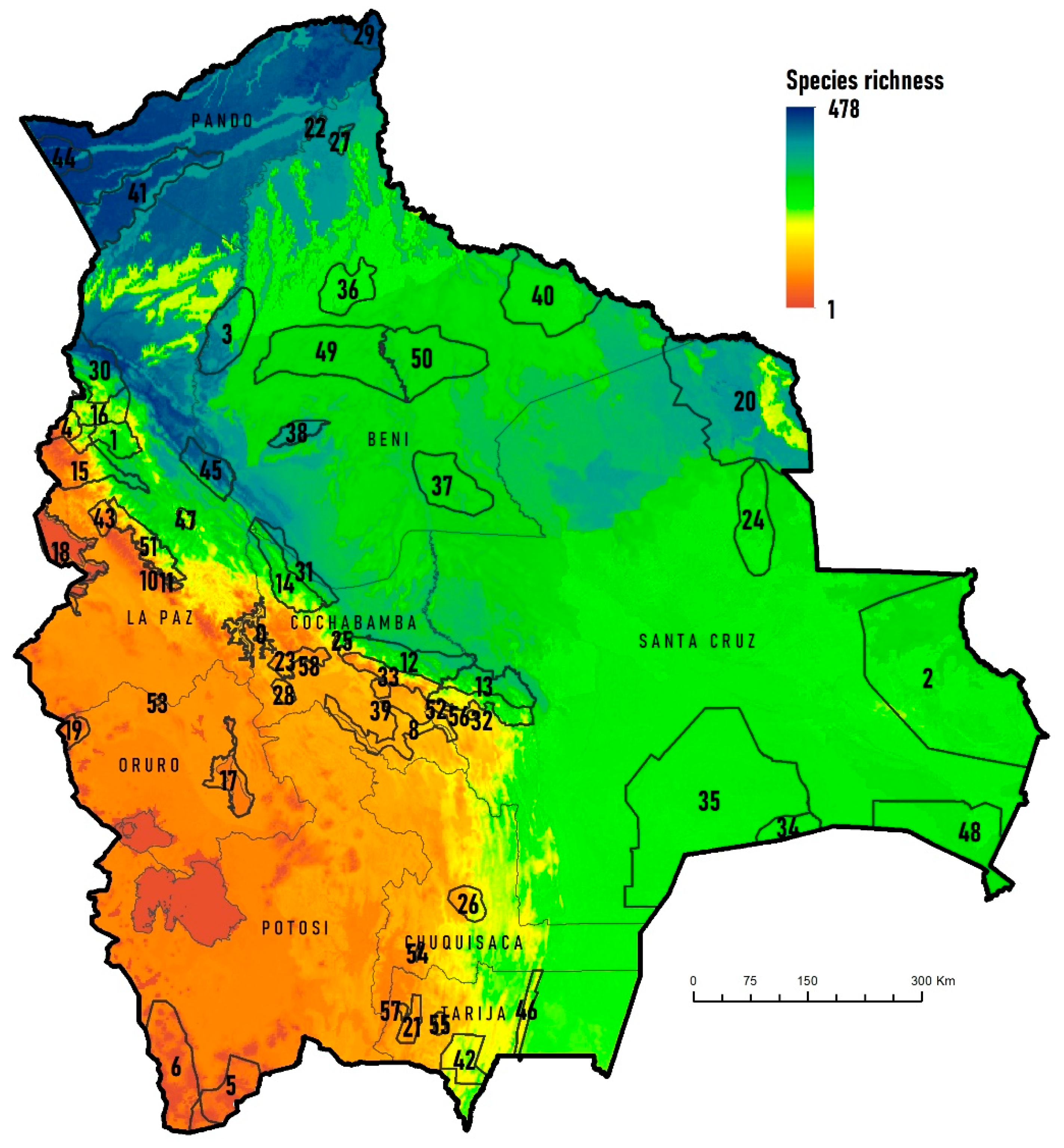
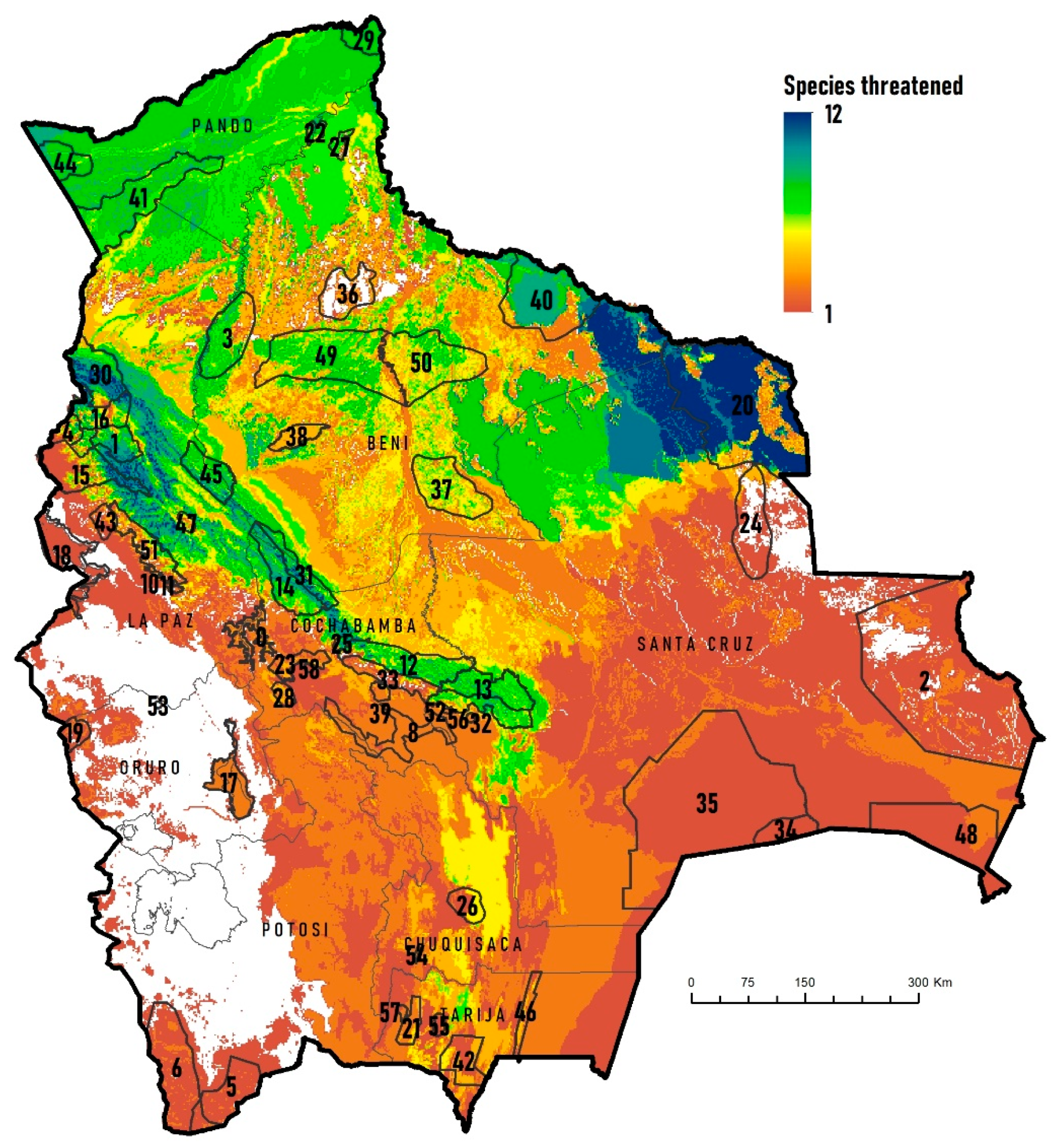
Figure 1. Bolivia’s Key Biodiversity Areas (KBA) affected by wildfires in the last two decades: (a) KBA Parque Nacional Noel Kempff Mercado, Serranía de Huanchaca (Claudia Belaunde/FCBC), (b) KBA Oeste del río Mamoré, río Ormi (Asociación Armonía), (c) KBA Área Natural de Manejo Integrado San Matías (Hermes Justiniano).
Fire 05 00004 g001
Figure 2. Some priority species for conservation, whose distribution areas were most affected by wildfires during the period 2001–2020: (a) Blue-throated Macaw Ara glaucogularis (Gerrit Vyn/Asociación Armonía), (b) Cock-tailed Tyrant Alectrurus tricolor (Lennart Verheuvel/Asociación Armonía), and (c) Sharp-tailed Tyrant Culicivora caudacuta (Lennart Verheuve/Asociación Armonía).
Fire 05 00004 g002
Figure 3. Total bird species richness in relation to the KBAs of Bolivia.
Fire 05 00004 g003
Figure 4. Threatened bird species (Critically Endangered, Endangered, Vulnerable) in relation to Bolivia’s KBAs.
Fire 05 00004 g004
Figure 5. Endemic bird species in relation to the KBAs of Bolivia.
Fire 05 00004 g005
Figure 6. Area burned annually in the period 2001–2020 in the KBAs and in the rest of the national territory.
Fire 05 00004 g006
Figure 7. Frequency of wildfires in the KBA of Bolivia, in the period 2001–2020 based on the MCD64A1 product.
Fire 05 00004 g007
Figure 8. Frequency of annual forest wildfires (%) in relation to total bird richness in Bolivia (a) and only KBA (b), threatened bird species in Bolivia (c) and only KBA (d), endemic bird species in Bolivia (e) and only KBA (f).
Fire 05 00004 g008
Figure 9. Percentage of annual fire impact by land cover types in the period 2002–2020, in Bolivia (left) and the KBAs (right).
Fire 05 00004 g009
Figure 10. Intensity of wildfires in the KBA of Bolivia for the period 2001–2020, based on the interpolation of the Radiative Power of Fire (Megawatts) based on the MODIS Collection 6.1 product.
Fire 05 00004 g010
Table 1. Maximum pixel value of 1′ × 1′ for total, endemic and threatened bird richness in the KBAs of Bolivia.
KBA CodeKBA NameRichnessThreatenedEndemic
1Apolo32691
2Área Natural de Manejo Integrado San Matías3193-
3Bajo Río Beni, Región Tacana42691
4Bosque de Polylepis de Madidi2629-
5Lagunas de Agua Dulce de Potosí652-
6Lagunas Salinas de Potosí732-
7Cuenca Cotacajes19335
8Cuencas de los Ríos Caine y Mizque18435
9Bosque de Polylepis de Sanja Pampa7123
10Bosque de Polylepis de Mina Elba7732
11Bosque de Polylepis de Taquesi9143
12Yungas Inferiores de Carrasco35594
13Yungas Inferiores de Amboró35982
14Yungas Superiores de Mosetenes y Cocapata39494
15Yungas Superiores de Apolobamba344111
16Yungas Superiores de Madidi415101
17Lago Poopó y Río Laka Jahuira872-
18Lago Titicaca (Sector Boliviano)952-
19Parque Nacional Sajama843-
20Noel Kempff Mercado42912-
21Reserva Biológica Cordillera de Sama1324-
22Cercanías de Riberalta42071
23Vertiente Sur del Parque Nacional Tunari14534
24Alto Paraguá3184-
25Cristal Mayu y alrededores33194
26Azurduy21841
27Cerrado de Riberalta4036-
28Cerro Q’ueñwa Sandora13233
29Federico Román4636-
30Yungas Inferiores de Madidi46511-
31Yungas Inferiores de Isiboro-Sécure418102
32Yungas Superiores de Amboró30885
33Yungas Superiores de Carrasco30875
34Palmar de las Islas2691-
35KAA-Iya del Gran Chaco2822-
36Laguna Rogaguado y Ginebra3366-
37Loreto3337-
38Estación Biológica del Beni3785-
39Quebrada Mojón1333-
40Reserva de Inmobilización de Iténez34910-
41Reserva Nacional Amazónica Manuripi4647-
42Reserva Nacional de Flora y Fauna Tariquia2404-
43Tacacoma-Quiabaya y Valle Sorata19342
44Tahuamanu47471
45Yungas Inferiores de Pilón Lajas45093
46Serranía de Aguaragüe24843
47Serranía Bella Vista30371
48Área Natural de Manejo Integrado Otuquis2972-
49Oeste del río Mamoré33382
50Este del río Mamoré33382
51Cotapata30194
52Comarapa20933
53Río Huayllamarca80--
54Culpina1083-
55Río Guadalquivir1483-
56Pampa Redonda21342
57Prepuna del área del río San Juan1132-
58Cochabamba11412
Table 2. Global Moran’s I index of Bolivia’s burned areas during 2001–2020. Significance (p < 0.05) is represented by an asterisk.
YearMoran’s Indexz-Scorep-ValueDistance Threshold (km)
20010.00562.62430.0087 *113.4
20020.00335.44080.0000 *188.1
20030.016310.37680.0000 *70.3
20040.00282.64780.0081 *90.4
20050.00392.94020.0033 *91.0
20060.00455.62740.0000 *247.9
20070.00393.26030.0011 *125.9
20080.01207.37010.0000 *114.1
20090.00705.24650.0000 *101.6
20100.00342.49880.0125 *86.2
20110.00421.67450.094067.5
20120.00692.67920.0074 *87.0
20130.00833.79170.0002 *128.2
20140.023713.23230.0000 *150.9
20150.01226.62710.0000 *150.5
20160.00627.77850.0000 *311.1
20170.01096.73890.0000 *165.3
20180.01427.82380.0000 *128.7
20190.00151.20750.2272150.5
20200.01565.74120.0000 *86.0
Publisher’s Note: MDPI stays neutral with regard to jurisdictional claims in published maps and institutional affiliations.

