1. Introduction
Coastal lagoons are transitional aquatic systems characterized by limited connections with the open sea through natural or artificial inlets. These environments are sheltered from high-energy marine conditions by barrier systems and are influenced by a complex interplay of marine, fluvial, atmospheric, and anthropogenic processes [
1]. As a result, sedimentary dynamics, depositional patterns, and environmental evolution can vary significantly depending on basin morphology, degree of confinement, and hydrodynamic regime. Despite their widespread distribution along Mediterranean coastlines, modern depositional processes in coastal lagoons remain incompletely understood [
2], particularly in systems characterized by strong bathymetric contrasts. In this context, Lake Faro (LF; Messina, NE Sicily, Italy) represents an exceptional case. The lake is characterized by the coexistence of a shallow, sub-horizontal platform and a steep-sided deep basin reaching nearly 30 m in depth within a very limited area. Although the peculiar morpho-bathymetric configuration of LF has been documented in previous studies, the sedimentological implications of this setting have not yet been investigated in detail.
The aim of this study is to provide a comprehensive sedimentological and geological characterization of the LF bottom sediments through grain-size, petrographic, statistical, and GIS-based analyses. Particular attention is devoted to (i) the spatial distribution of sediment textures across the shallow platform and deep basin; (ii) the interpretation of present-day depositional environments; and (iii) the identification of Holocene beachrocks that exert a significant morpho-structural control on the development of the shallow platform.
2. Geological and Structural Background
Lake Faro is located on the Cape Peloro peninsula, a coastal plain developed at the northeastern margin of the Peloritani Mountains, facing both the Tyrrhenian and Ionian seas (
Figure 1a). Lake Faro is separated from the Tyrrhenian Sea by a narrow barrier system and is connected to both the Tyrrhenian and Ionian seas through artificial canals, which play a key role in regulating water exchange and sediment transport.
The Peloritani Mountains represent the southernmost sector of the Calabria–Peloritani Arc and form part of an Alpine orogenic belt composed predominantly of Paleozoic crystalline basement rocks overlain by remnants of Mesozoic–Cenozoic sedimentary successions (
Figure 1a–d) [
3,
4,
5,
6,
7,
8]. Following the main compressional phases, late- to post-orogenic sedimentary deposits accumulated above the tectonic units. During the Pliocene–Pleistocene, extensional tectonics associated with regional rifting and sea-level fluctuations strongly influenced the geomorphological evolution of the area [
3,
4]. These processes contributed to the development of coastal plains, lagoon systems, and locally graben-like structures that exert significant control on basin geometry. The Cape Peloro peninsula is composed mainly of Holocene coastal and alluvial deposits, consisting of sand, gravel, and cobble [
9,
10,
11]. Upper Holocene beachrocks dating back to 6 ka BP [
3,
4] are present along the peninsula coast [
12].
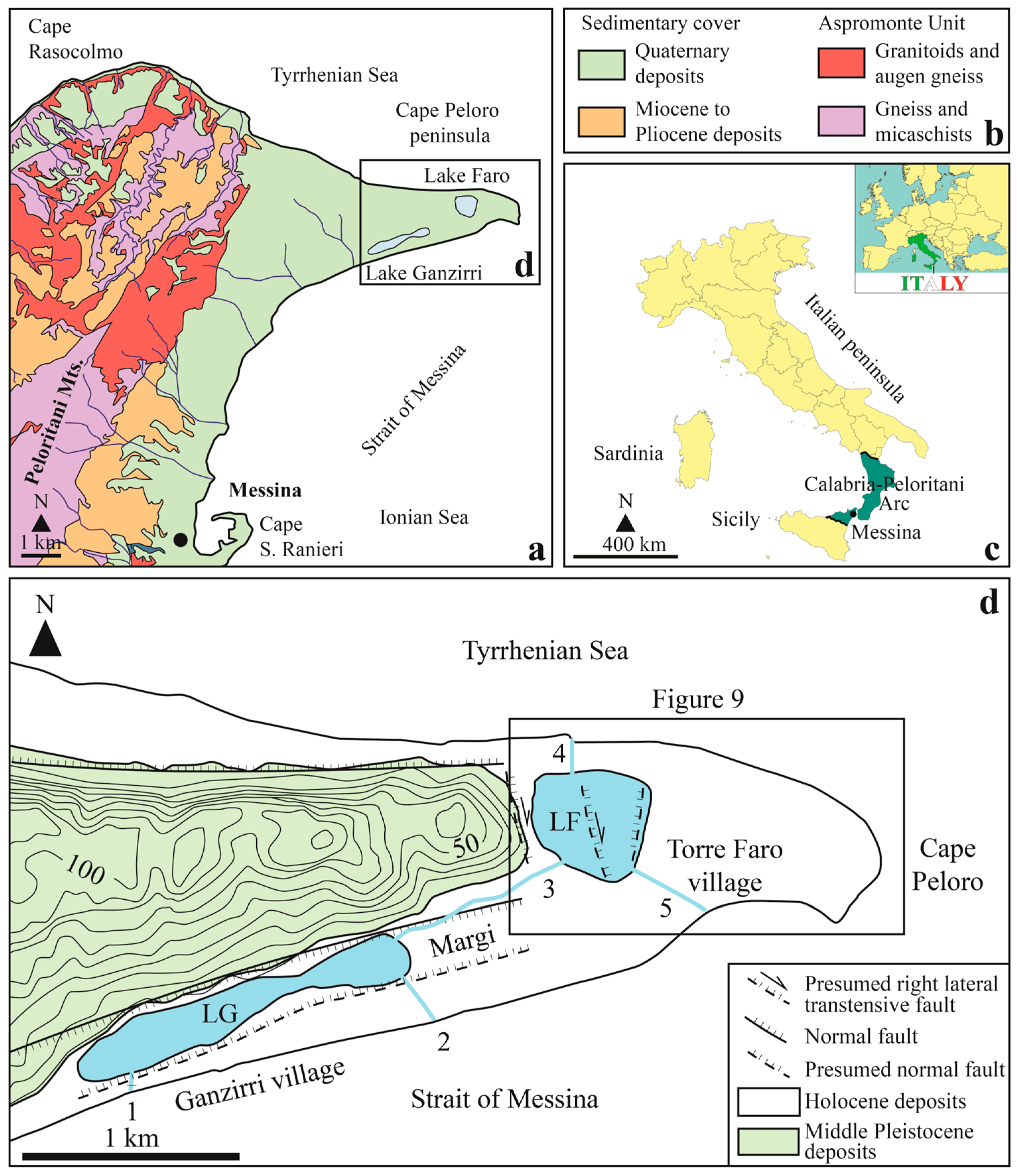
Figure 1.
Geological and geographical framework of the study area (modified from [
11]). (
a) Geological sketch map of the northeastern Peloritani Mountains with the location of the Cape Peloro peninsula. (
b) Legend of the geological sketch map. (
c) Geographic extent of the Calabria–Peloritani Arc. (
d) Geological and structural map of the Cape Peloro peninsula. Acronyms—1: Canal Catuso, 2: Canal Due Torri, 3: Canal Margi, 4: Canal degli Inglesi, 5: Canal Faro.
Figure 1.
Geological and geographical framework of the study area (modified from [
11]). (
a) Geological sketch map of the northeastern Peloritani Mountains with the location of the Cape Peloro peninsula. (
b) Legend of the geological sketch map. (
c) Geographic extent of the Calabria–Peloritani Arc. (
d) Geological and structural map of the Cape Peloro peninsula. Acronyms—1: Canal Catuso, 2: Canal Due Torri, 3: Canal Margi, 4: Canal degli Inglesi, 5: Canal Faro.
2.1. Study Area
Lake Faro forms part of the Cape Peloro peninsula lagoon system, which also includes the nearby Lake Ganzirri (
Figure 1a). This coastal area is protected as a natural reserve and is mainly composed of recent coastal and alluvial deposits, consisting of thick successions of sand with pebble and cobble, as well as gravel (see Ref. [
11] and references therein). These sediments derive from the erosion of Variscan high-grade metamorphic rocks of the Aspromonte Unit and from the reworking of middle Pleistocene siliciclastic deposits of the Messina Formation (
Figure 1a,d).
In the village of Torre Faro, the LF coastal system faces the Tyrrhenian Sea, from which it is separated by a barrier system located between the lake’s northern shoreline and the sea, with a minimum distance of approximately 143 m. The lake is periodically connected to the Tyrrhenian Sea through the Canal degli Inglesi (
Figure 1d, no. 4), which cuts across the barrier system. A second canal, the Canal Faro (
Figure 1d, no. 5), connects Lake Faro to the Ionian Sea, ensuring continuous and significant water exchange. In addition, the Canal Margi (
Figure 1d, no. 3) links LF to the adjacent Lake Ganzirri, indirectly providing a further connection to the Ionian Sea (see Ref. [
9] and references therein).
2.2. Previous Morpho-Bathymetric and Morpho-Structural Studies
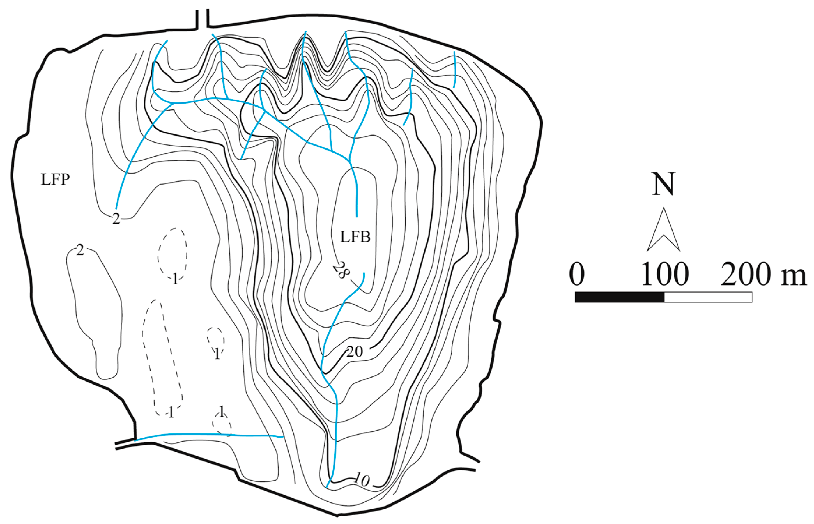
Lake Faro covers an area of approximately 263,600 m
2 and has an almost circular planform, with a major east–west axis of about 587 m and a minor north–south axis of about 560 m (
Figure 2). The morpho-bathymetric map of the lake, obtained using a single-beam echosounder, highlights the presence of two sharply contrasting morpho-bathymetric domains: a shallow platform and a deep basin [
9].
The shallow sector, which occupies nearly half of the total lake area, is located in the western portion of the basin. The Lake Faro Platform (LFP) is sub-horizontal to gently eastward-dipping and extends over an area of approximately 87,522 m
2, with water depths generally ranging between ~1 and 2 m (
Figure 2).
The Lake Faro Basin (LFB) displays a symmetric, funnel-shaped morphology bounded by two steep slopes with opposite dips and opening northward. It occupies an area of approximately 175,963 m
2 in the eastern sector of the lake and includes a deep basin about 290 m wide, reaching maximum depths of 29 m (
Figure 2). Despite its limited surface area, this feature makes LF the deepest coastal lake in Italy. The exceptional depth of the basin has been interpreted as the result of tectonic control exerted by a N-S-trending graben structure [
9].
Two main subaqueous channels are recognized on the lake floor (
Figure 2). The northern channel exhibits a complex pattern, trending E-W in its shallow apical sector and progressively shifting to a N-S orientation southward. The southern channel trends N-S and gradually rotates to a NNE-SSW orientation toward the north. Both channels converge toward the deepest part of the LFB. Several second-order tributaries with a N-S orientation occur on the hydrographic left side of the northern channel. An additional E-W-trending tributary, corresponding to the subaqueous continuation of the Canal Margi, develops in the southern portion of the platform (
Figure 2).
2.3. Previous Studies on the Paleogeographic Evolution
An initial reconstruction of the paleogeographic evolution of LF was proposed by Segre et al. [
12], who suggested that environmental confinement was very low during the Early to Middle Bronze Age. At that time, a more extensive lagoonal system, directly connected to both the Tyrrhenian and Ionian seas, occupied the area. Historical sources from the Greek and Roman periods report the presence, during the 5th century BC, of a natural harbor capable of accommodating up to one hundred vessels in the area presently occupied by LF [
13]. Connections between the lake and the sea are thought to have progressively diminished during the Late Bronze Age, around 2600 years BP [
14,
15]. Following the natural isolation of the lagoon, anthropogenic interventions carried out at the end of the 18th century, during British rule, disrupted this long-standing isolation through the excavation of artificial canals designed to re-establish connections between LF and both the Tyrrhenian and Ionian seas. Concurrent drainage works were also undertaken in the surrounding wetlands to mitigate the spread of disease vectors [
16].
3. Materials and Methods
3.1. Sampling Strategy
Bottom sediment samples were collected from LF using a Van Veen grab sampler during a dedicated field campaign. A total of 26 surface-sediment samples were collected, covering both the LFP and the LFB, in order to adequately capture spatial variations in sediment texture and composition. Sampling locations were selected based on bathymetric variability and geomorphological features identified from previous morpho-bathymetric surveys, including slopes, channels, and the basin depocenter. Sample depths ranged from approximately 1 m on the shallow platform to nearly 29 m within the deep basin. All samples were stored in sealed containers and transported to the laboratory for further analysis.
3.2. Grain Size Analyses and Classification
Grain-size analyses were carried out on all sediment samples following standard procedures. Prior to analysis, samples were oven-dried at low temperature and treated with hydrogen peroxide (H
2O
2) to remove organic matter. Carbonate removal was not performed in order to preserve the original grain-size distribution of carbonate-rich sediments. The coarse fraction (>63 µm) was analyzed by wet sieving at half-phi intervals, while the fine fraction (<63 µm) was analyzed using a laser diffraction particle size analyzer (Mastersizer 2000, Malvern Panalytical, Malvern, UK) [
17,
18]. Grain-size distributions were expressed in phi (φ) units following the logarithmic scale proposed by Krumbein [
19]. Statistical grain-size parameters, including mean, median, sorting, skewness, and kurtosis, were calculated using the Folk and Ward graphical method [
20]. Soft sediments were classified according to the Italian Geotechnical Association sediment nomenclature [
21].
3.3. Statistical Analyses
Grain-size parameters were further analyzed using bivariate plots and multivariate statistical techniques to identify relationships between sediment texture and depositional processes. In particular, discriminant function analysis following the method proposed by Sahu [
22] was applied to distinguish between different hydrodynamic regimes. Discriminant functions were calculated using combinations of grain-size statistical parameters, and the resulting plots were used to infer relative energy conditions and depositional environments. Multivariate analyses were performed using the PRIMER v6 statistical software application [
23]. Although these methods provide useful comparative insights, their results were interpreted cautiously and in conjunction with sedimentological and geomorphological evidence.
3.4. GIS-Based Mapping
Spatial distribution maps of grain-size parameters and sedimentological features were produced using a Geographic Information System (GIS). The software used for processing and visualizing data was QGIS Desktop (version 3.28.10, Florence) [
24]. Sample data were interpolated using appropriate geostatistical methods to generate continuous surfaces representing mean/median grain size, sorting, skewness, kurtosis, and sediment distribution. Bathymetric data were integrated with sedimentological datasets to examine the relationship between basin morphology and sediment distribution. All maps were generated using the same coordinate reference system to ensure spatial consistency and facilitate comparison between datasets.
3.5. Petrographic and Mineralogical Analyses
Petrographic and mineralogical analyses were conducted on selected sediment samples representative of the main depositional environments of the bottom lake. The coarse fraction was examined under a binocular stereomicroscope equipped with transmitted light (Zeiss Stereo Discovery, Oberkochen, Germany) to identify lithological components and assess grain shape and roundness. For cemented samples, thin sections were prepared and analyzed under a polarizing optical microscope (Zeiss Axio Vision, Oberkochen, Germany). Petrographic observations focused on grain composition, fabric, cement type, and diagenetic features in order to characterize lithification processes and depositional conditions.
4. Results
4.1. Sampling Stations
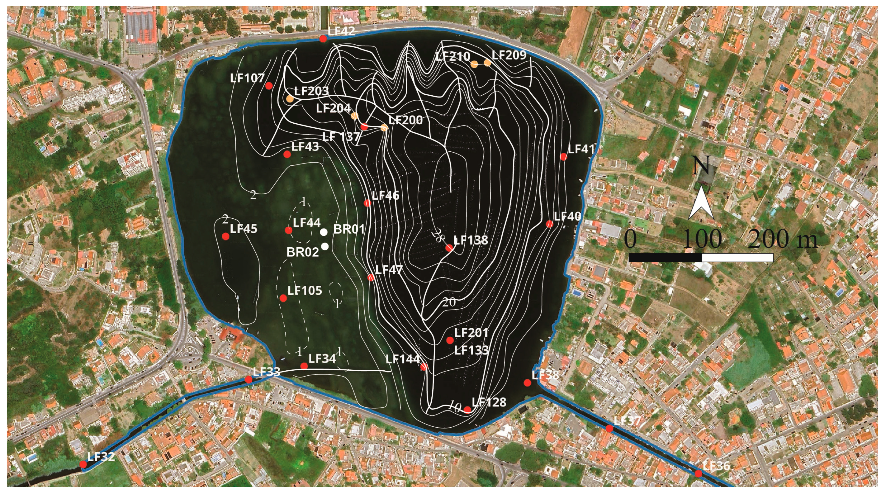
The locations of the 33 stations within LF and the connected canals are shown in
Figure 3. Grain-size analyses enabled the textural characterization of 26 bottom sediment samples, including 17 collected within the lake and nine from the connecting canals (
Figure 3). Most of the sampling sites are characterized by sandy to gravelly sediments. The
Supplementary Materials contain the grain-size analysis data (
Figure S1). Two samples of strongly cemented clastic sediments were collected on the LFP at approximately 1 m water depth (samples BR01–02). At five stations, a hard substrate of unknown origin was encountered. Although scuba-diving observations did not allow discrimination between natural and anthropogenic materials, integration with data from nearby outcrops suggests that this substrate corresponds to middle Pleistocene sands and gravels of the Messina Formation. The results were additionally compared with grain-size data from ten beach samples collected along the coast of the Cape Peloro peninsula.
4.2. Cumulative Curves and Grain-Size Distributions
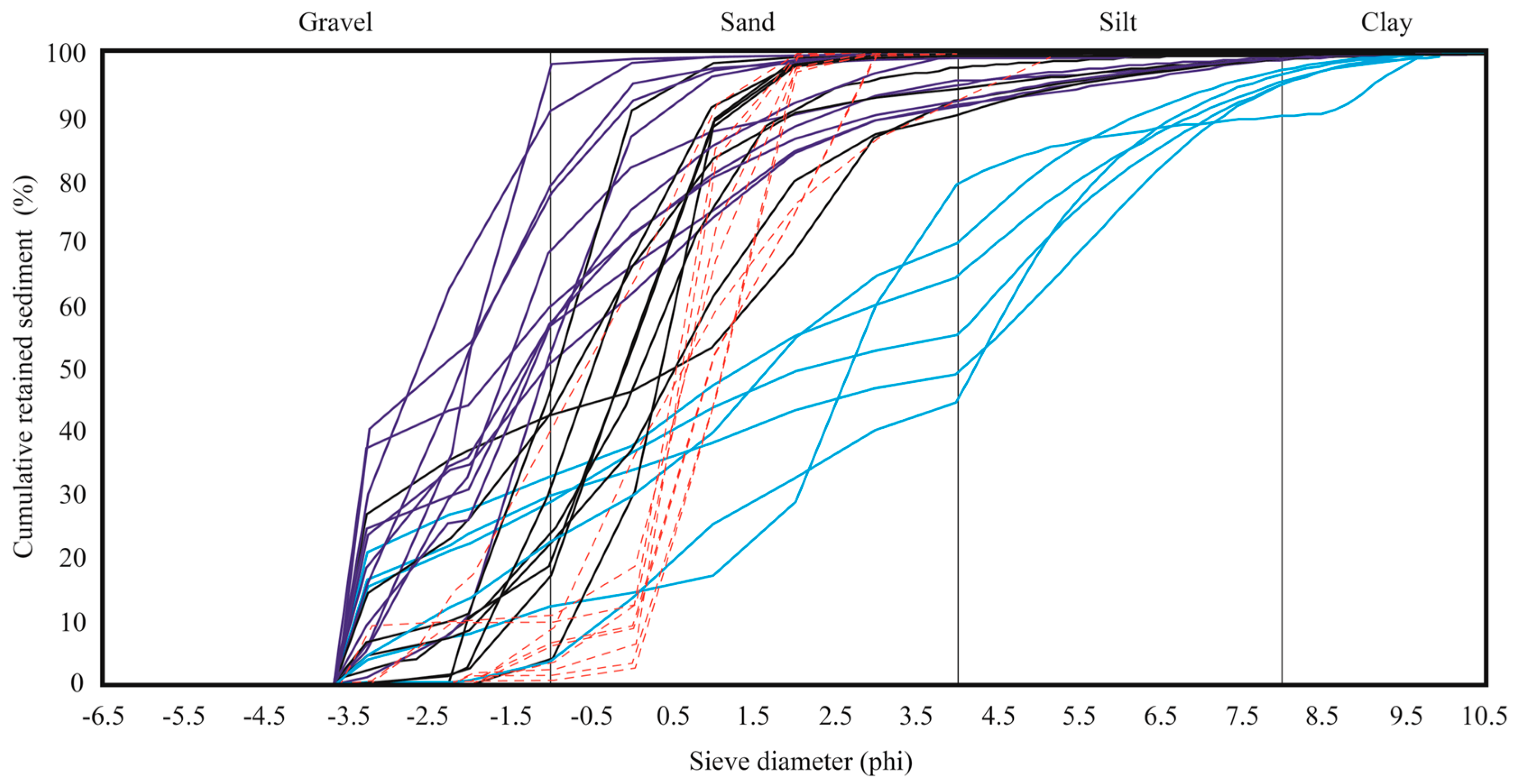
Cumulative grain-size curves (
Figure 4) for platform sediments display low slopes and broad distributions, consistent with poor sorting. Frequency curves commonly show polymodal or bimodal distributions, indicating the coexistence of multiple sediment populations. These characteristics suggest the simultaneous presence of coarse skeletal fragments and finer sand fractions within the same depositional setting. Cumulative curves of basin sediments (
Figure 4) show very low slopes, indicative of extremely poor sorting. The
Supplementary Materials contain the frequency and cumulative curves of the fine fraction (
Figure S2).
4.3. Soft Sediment Classification
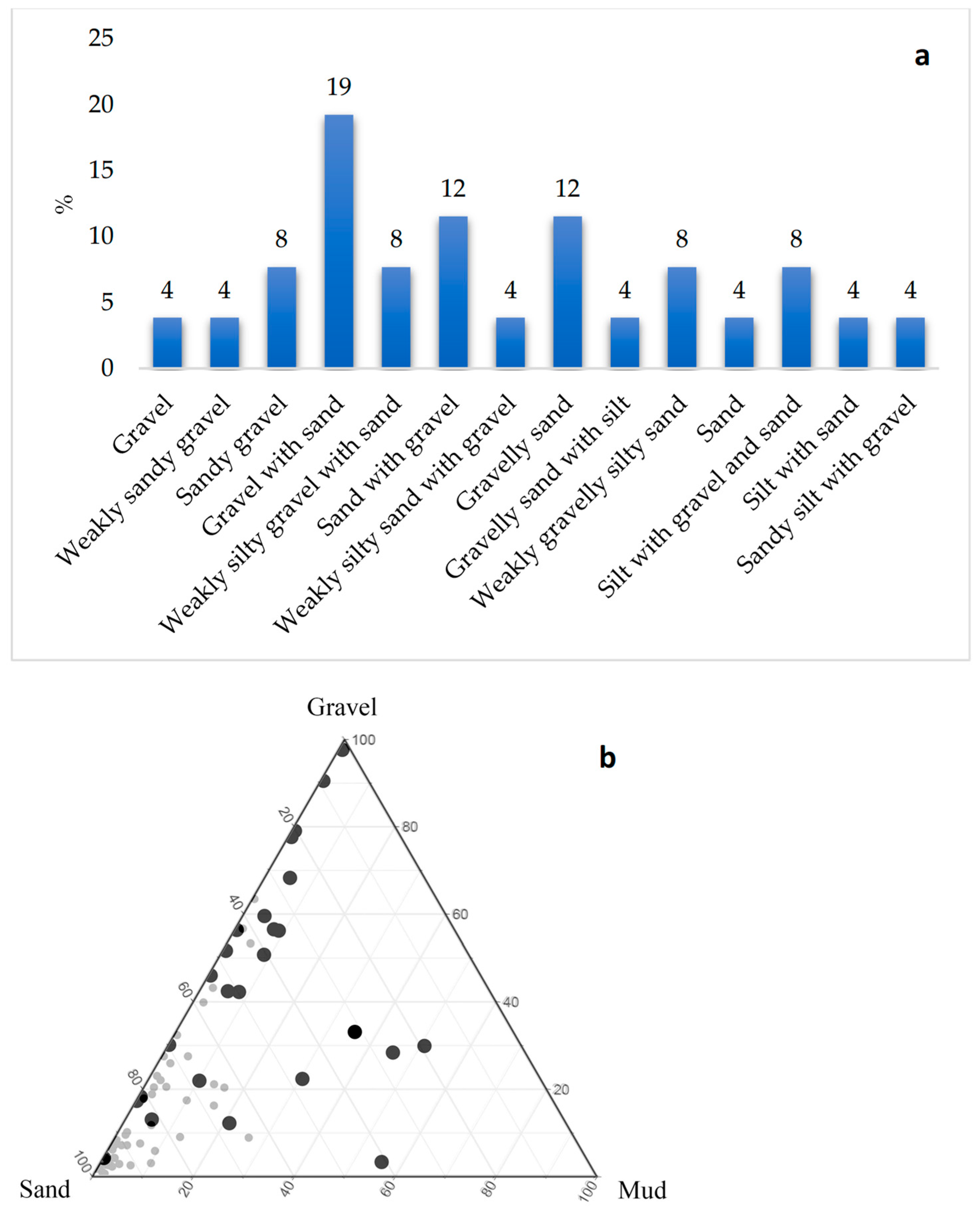
The analyzed sediments are predominantly coarse-grained, with gravel and sand each accounting for 42.3% of the total samples, whereas fine-grained deposits represent only 15.4%. Application of the Italian Geotechnical Association sediment classification [
21] allowed the identification of five gravel, six sand, and three silt sediment types, together with their relative abundances (
Figure 5a), which are also displayed in the ternary diagram (
Figure 5b). Gravelly sediments are mainly represented by gravel with sand, sandy gravel, weakly silty gravel with sand, weakly sandy gravel, and gravel (
Figure 5). Sandy sediments include sand with gravel and gravelly sand, as well as weakly silty sand with gravel, weakly gravelly silty sand, gravelly sand with silt, and sand (
Figure 5). Silty sediments comprise silt with gravel and sand, silt with sand, and sandy silt with gravel (
Figure 5).
4.4. Mean and Median Grain Size
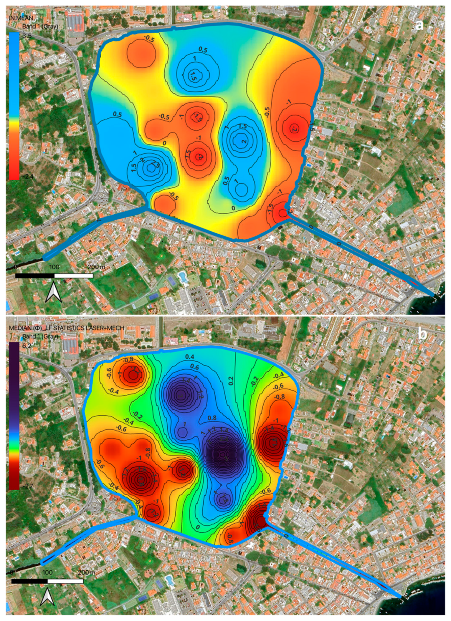
Platform sediments are characterized by coarse grain sizes, ranging from gravel to medium-grained sand (
Figure 6). Mean grain-size values are predominantly within the gravel and very coarse-grained sand classes (
Figure 6a), while median values indicate a dominance of coarse- to medium-grained sand (
Figure 6b). Coarser sediments are mainly concentrated along the platform margins and nearshore areas, whereas relatively finer sand occurs toward the central portion of the platform (
Figure 6).
Basin sediments are markedly finer than those of the platform. Mean grain-size values are predominantly within the fine-grained sand to silt classes, with the finest sediments occurring in the deepest portion of the basin (
Figure 6a). Median grain-size values confirm this trend, highlighting a progressive fining toward the basin depocenter (
Figure 6b).
4.5. Sorting, Skewness, and Kurtosis
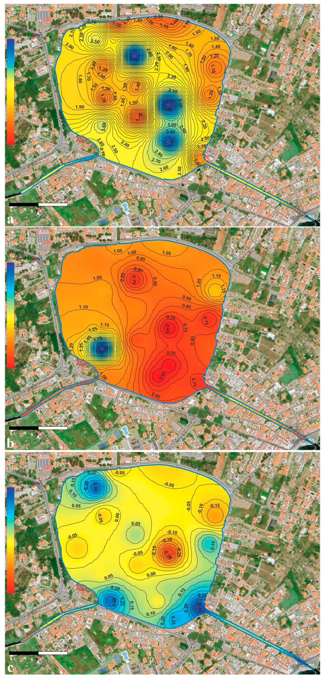
Platform sediments exhibit generally poor to very poor sorting, reflecting a wide range of grain sizes within individual samples. Sorting values indicate heterogeneous sediment populations, with no clear trend toward improved sorting across the platform (
Figure 7a). Skewness values vary from fine- to coarse-skewed, indicating asymmetric grain-size distributions (
Figure 7b). Kurtosis values range from platykurtic to leptokurtic, reflecting variability in the peakedness of grain-size curves (
Figure 7c).
Basin sediments are characterized by very poor to extremely poor sorting. Sorting values indicate the presence of mixed sediment populations, with a significant contribution from fine fractions (
Figure 7a). Skewness values are predominantly fine-skewed, reflecting an enrichment in fine particles (
Figure 7b). Kurtosis values range from mesokurtic to leptokurtic, suggesting variable degrees of sorting within the fine-grained sediment population curves (
Figure 7c).
4.6. Fine Fraction and Organic Matter Content
The proportion of the fine fraction (<63 µm) increases significantly with water depth. Fine sediments are scarce on the shallow platform but become dominant in the deep basin, where they locally exceed 50% of the total sediment mass. Organic matter content follows a similar spatial pattern, with low values on the platform and higher concentrations on the basin. The highest organic contents are recorded on the deepest basin areas, where fine-grained sediments prevail.
4.7. Petrographic Composition
Petrographic analysis of modern unconsolidated sediments reveals a composition dominated by quartz, feldspars, metamorphic lithoclasts, and granitoid fragments. Minor components include carbonate bioclasts and shell fragments. Grain shapes range from angular to sub-rounded, indicating limited transport and reworking. The compositional assemblage reflects derivation from nearby crystalline basement rocks and reworked Pleistocene deposits.
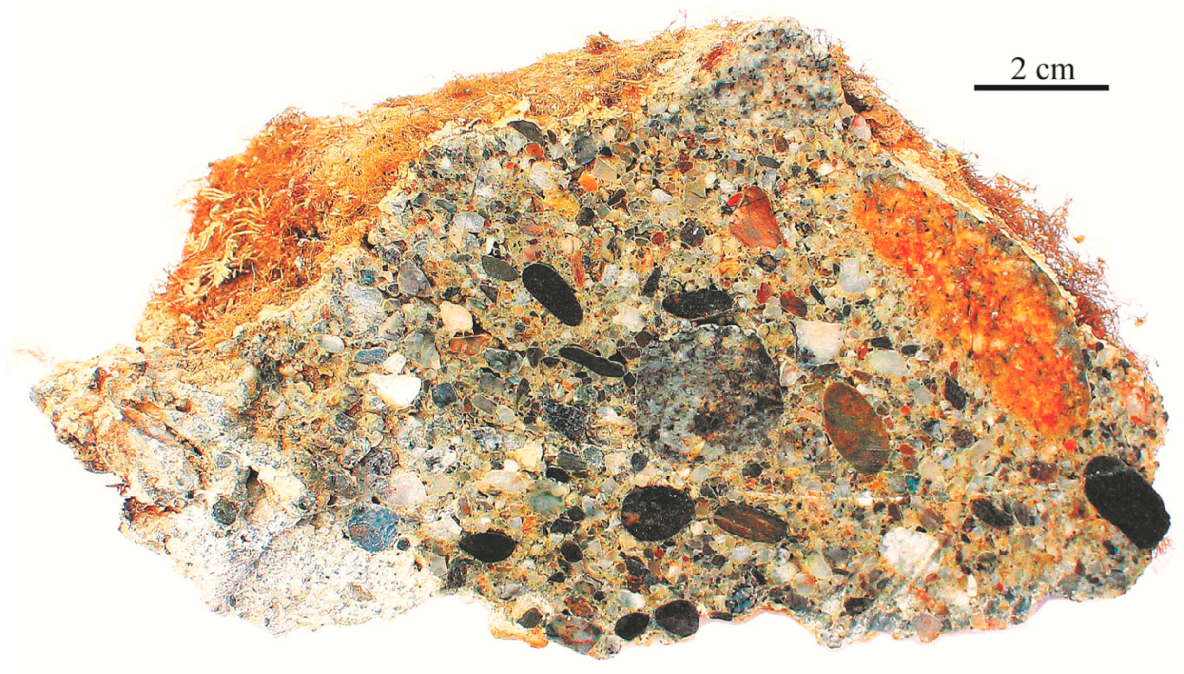
Cemented samples collected beneath the shallow platform cover display clast-supported textures composed of conglomerate (
Figure 8). Clasts consist predominantly of metamorphic and granitoid lithologies. Thin-section observations reveal carbonate cement binding the clasts, forming a rigid framework. The cement occurs mainly as micritic to microsparitic carbonate, locally displaying meniscus and fringe textures.
4.8. Geological Map
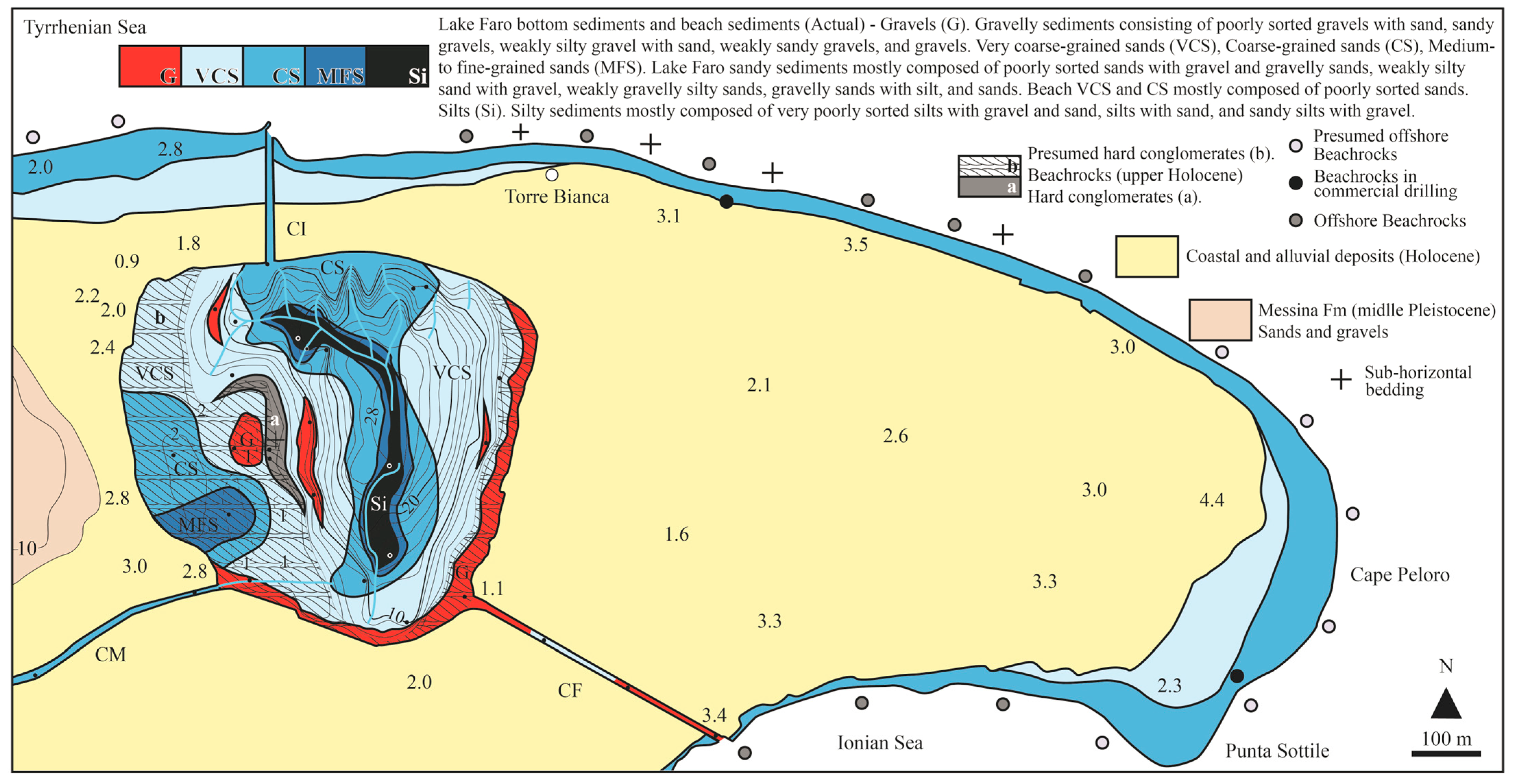
Figure 9 shows the geological map of the Cape Peloro peninsula.
Along the Tyrrhenian and Ionian seas, the beach system is characterized by very coarse-grained sand on the backshore. Seaward, sediment grain size decreases slightly on the foreshore, where coarse-grained sand predominates. In the nearshore zone, gravel is locally present in belts a few meters wide (
Figure 9).
These beach deposits overlie Holocene beachrocks, as documented in the literature [
3,
4]. They are widely exposed underwater along a several km-long belt, approximately 110 m wide, subparallel to the coastline, extending onshore and occurring at elevations lower than ~1 m a.s.l. (
Figure 9).
On the platform of the LF, the modern unconsolidated sediment cover is dominated by coarse-grained deposits, including gravel, very coarse-grained sand with gravel lenses, coarse-, and medium- to fine-grained sand (
Figure 9). In contrast, the basin is dominated by fine-grained sediments, such as coarse-grained silt with sand, sandy silt with gravel, and silt containing both gravel and sand (
Figure 9).
Sub-horizontal cemented hard rocks, identified beneath the modern unconsolidated sediment cover of the LF shallow platform, consist of clast-supported conglomerates with a sandy matrix and carbonate cement. These deposits, ~1.5 m thick, are interpreted as upper Holocene beachrocks based on their composition, texture, stratigraphic position, and comparison with the beachrock outcrops exposed along the Cape Peloro coastline (
Figure 9) [
3,
4]. The beachrock setting, never detected until now, is likely responsible for the overall sub-horizontal morpho-structure of the LF platform.
5. Discussion
5.1. Sediment Distribution and Bathymetric Control
The sedimentological architecture of Lake Faro is primarily governed by its pronounced bathymetric asymmetry, which partitions the lake floor into two functionally distinct depositional domains: a shallow platform and a deep basin. Grain-size parameters, petrographic data, and spatial distribution maps consistently indicate a sharp transition between these domains at approximately 10 m water depth. The LFP is dominated by coarse-grained sediments (gravel and very coarse- to medium-grained sand) characterized by poor to very poor sorting and variable skewness. These features reflect high-energy, low-confinement conditions, comparable to beach and open-lagoon environments. Continuous sediment reworking by wind-driven waves, combined with water exchange through the artificial canals, favors the accumulation and persistence of coarse deposits across the platform. In contrast, the LFB represents a markedly different depositional setting. Fine-grained, organic-rich sediments dominate the basin floor, particularly toward the depocenter, where extremely poor sorting and fine-skewed distributions prevail. These characteristics indicate lower-energy, more confined conditions, where suspended material preferentially accumulates. The progressive fining trend from the platform margins toward the basin depocenter highlights the strong influence of depth-related energy attenuation on sedimentation.
5.2. Sediment Transport Processes and Basin Infill
Beyond simple hydrodynamic sorting, the textural properties of deep-basin sediments suggest the contribution of gravity-driven processes. The extremely poor sorting, mixed grain-size populations, and downslope fining patterns observed along basin slopes and channels are consistent with episodic sediment gravity flows transporting material from the platform toward the basin depocenter. Such processes likely operate during high-energy events, including storms or exceptional inflow conditions, and complement background suspension settling. Elevated organic-matter contents and dark sediment coloration in the deepest basin areas further indicate reduced bottom-water circulation and locally anoxic conditions. These environmental conditions promote fine-particle preservation and limit post-depositional reworking, reinforcing the contrast between the LFB and the highly dynamic platform environment.
5.3. Statistical Differentiation of Depositional Environments
Bivariate and multivariate statistical analyses corroborate the sedimentological distinction between the platform and basin domains. Discriminant function analysis clearly separates coarse-grained, high-energy platform sediments from finer, lower-energy basin deposits, while cluster analysis identifies sediment populations that spatially correspond to the main morpho-bathymetric units. Rather than introducing additional depositional settings, the statistical results reinforce the interpretation of two end-member environments within LF. Intermediate sediment types primarily occur along transitional zones, such as basin slopes and channel mouths, where sediment mixing and episodic transport processes are most active. The
Supplementary Materials contain the results of the bivariate analysis (
Figure S5), the multivariate analysis (
Figure S6), and the cluster analysis (
Figure S7).
5.4. Role of Holocene Beachrocks in Platform Development
A key outcome of this study is the identification of cemented conglomerates beneath the modern cover of the shallow platform, interpreted as upper Holocene beachrocks. Their composition, clast-supported fabric, carbonate cementation, and stratigraphic position are consistent with shallow-water lithification processes documented along the Cape Peloro coastline. The sub-horizontal geometry and lateral continuity of these beachrock bodies strongly suggest a morpho-structural control on the development and persistence of the LFP. Acting as a resistant substratum, the beachrocks likely stabilized the platform surface and influenced sediment distribution patterns by limiting erosion and accommodation space. This finding extends the known beachrock system landward into the lake environment and provides new insights into the late Holocene palaeogeographic evolution of the area. The recognition of subaqueous channel networks further refines previous interpretations of LF as a sheltered harbor, suggesting that navigable corridors may have existed in areas not obstructed by beachrock development. However, this hypothesis requires confirmation through targeted geophysical surveys and coring.
6. Conclusions
This study provides the first integrated geological and sedimentological characterization of the Lake Faro, demonstrating that modern depositional processes are strongly controlled by basin morphology and bathymetry. The lake floor is clearly subdivided into two contrasting depositional domains:
The shallow platform, characterized by coarse-grained, poor to very poorly sorted sediments deposited under high-energy and low-confinement conditions analogous to beach and open-lagoon environments.
The deep basin, dominated by fine-grained, very poor to extremely poorly sorted, organic-rich sediments accumulating under lower-energy, more confined conditions, where suspension settling and episodic gravity-driven transport play a key role.
Grain-size statistics, multivariate analyses, and spatial distribution maps consistently support this subdivision and highlight a sharp sedimentological transition at approximately 10 m water depth. A significant new outcome of this work is the identification of upper Holocene beachrock beneath the shallow platform’s modern cover. These cemented deposits likely exert a fundamental morpho-structural control on platform development, extending the known beachrock system of the Cape Peloro coastal area into the lake environment and influencing sediment accommodation and preservation. Overall, LF represents a unique Mediterranean coastal lake in which shallow, high-energy and deep, low-energy environments coexist within a confined basin. The results improve the understanding of sedimentary dynamics in morphologically complex lagoon systems and provide a robust framework for future studies addressing modern hydrodynamics, stratigraphy, environmental evolution, and morpho-structural control of beachrock in comparable coastal settings.
Supplementary Materials
The following supporting information can be downloaded at:
https://www.mdpi.com/article/10.3390/quat9020019/s1, Figure S1. Main textural statistical data of the total sediment samples: (a) Sorting. (b) Kurtosis. (c) Skewness. Figure S2. Fine sediment distributions (retained sediments) related to the fine fraction of the total sediment specimens sampled on the lake bottom. (a) Frequency curves. (b) Cumulative curves. Figure S3. Spatial distribution maps of central-tendency grain-size parameters for the fine fraction of the total sediments. (a) Mean. (b) Median. Figure S4. Spatial distribution maps of grain-size parameters for the fine fractions of the sediments. (a) Sorting. (b) Kurtosis. (c) Skewness. Figure S5. Bivariate plots. (a) Skewness versus Kurtosis. (b) Mean versus Skewness (c) Mean versus Sorting. Symbols. Lake Faro (solid red circle) sediments. Lake Ganzirri sediments (solid gray circle) were also reported for comparative purposes. Figure S6. Multivariate plots of discriminant functions: (a) Y1 versus Y2 and (b) Y2 versus Y3. Lake Faro sediments are represented by solid red circles, while Lake Ganzirri sediments (solid gray circles) are included for comparison. Figure S7. Cluster dendrogram of sediment samples based on their granulometric statistical parameters. Four main groups, together with a single isolated sample, are identified at a Euclidean distance of 2 (dotted line).
Author Contributions
Conceptualization, R.S. and S.G.; methodology, R.S. and S.G.; software, M.G.Y.; validation, R.S. and S.G.; formal analysis, R.S., M.G.Y. and S.G.; investigation, R.S. and S.G.; resources, R.S. and S.G.; data curation, R.S. and S.G.; writing—original draft preparation, R.S. and S.G.; writing—review and editing, R.S. and S.G.; visualization, R.S., S.G. and M.G.Y.; supervision, R.S. and S.G. All authors have read and agreed to the published version of the manuscript.
Funding
This work was supported by PO FEAMP (Fondo Europeo per gli Affari Marittimi e la Pesca) 2014/2020 measure 2.5.1.
Data Availability Statement
The original contributions presented in this study are included in the article/
Supplementary Materials. Further inquiries can be directed to the corresponding author.
Acknowledgments
The authors gratefully acknowledge Maria Letizia Molino (director of the Oriented Reserve of Capo Peloro, Metropolitan City of Messina) for granting sampling permission and providing logistical support. They thank the personnel of the mussel farms Farau S.r.l. (Messina) for their assistance during field work. The authors also thank Gabriele Denaro and Sergio D’Andrea (G8 S.r.l., Messina) for supplying drilling core data, as well as Salvatore Zaccaro and Raymart Keiser Manguerra (Ph3 Engineering S.r.l., Messina) for their guidance in the use of QGIS software. Finally, the authors sincerely acknowledge the reviewers for their insightful comments and constructive suggestions, which substantially improved the manuscript. Appreciation is also extended to the Academic Editor and the Assistant Editor for their support throughout the review process.
Conflicts of Interest
The authors declare no conflicts of interest.
Abbreviations
The following abbreviations are used in this manuscript:
| LF | Lake Faro |
| LFP | Lake Faro Platform |
| LFB | Lake Faro Basin |
References
- Siddiqui, N.A.; Rahman, A.H.A.; Sum, C.W.; Yusoff, W.I.W.; Bin Ismail, M.S. Shallow-marine sandstone reservoirs, depositional environments, stratigraphic characteristics and facies model: A review. J. Appl. Sci. 2017, 17, 212–237. [Google Scholar] [CrossRef]
- Woszczyk, M.; Tylmann, W.; Jedrasik, J.; Szarafin, T.; Stach, A.; Skrzypczak, J.; Lutynska, M. Recent sedimentation dynamics in a shallow coastal lake (Lake Sarbsko, northern Poland): Driving factors, processes and effects. Mar. Freshw. Res. 2014, 65, 1102–1115. [Google Scholar] [CrossRef]
- Antonioli, F.; Presti, V.L.; Morticelli, M.G.; Bonfiglio, L.; Mannino, M.A.; Palombo, M.R.; Sannino, G.; Ferranti, L.; Furlani, S.; Lambeck, K.; et al. Timing of the emergence of the Europe–Sicily bridge (40–17 cal ka BP) and its implications for the spread of modern humans. Geol. Soc. Lond. Spec. Publ. 2016, 411, 111–144. [Google Scholar] [CrossRef]
- Antonioli, F.; Calcagnile, L.; Ferranti, L.; Mastronuzzi, G.; Monaco, C.; Orrù, P.; Quarta, G.; Pepe, F.; Scardino, G.; Scicchitano, G.; et al. New evidence of mis 3 relative sea level changes from the Messina strait, Calabria (Italy). Water 2021, 13, 2647. [Google Scholar] [CrossRef]
- Bonardi, G.; Giunta, G.; Liguori, V.; Perrone, V.; Russo, M.; Zuppetta, A. Schema geologico dei Monti Peloritani. Boll. Soc. Geol. It. 1976, 95, 49–74. [Google Scholar]
- Cirrincione, R.; Fazio, E.; Fiannacca, P.; Ortolano, G.; Pezzino, A.; Punturo, R. The Calabria-Peloritani Orogen, a composite terrane in Central Mediterranean. Its overall architecture and geodynamic significance for a pre-Alpine scenario around the Tethyan basin. Period. Mineral. 2015, 84, 701–749. [Google Scholar] [CrossRef]
- Catalano, S.; Cirrincione, R.; Mazzoleni, P.; Pavano, F.; Pezzino, A.; Romagnoli, G.; Tortorici, G. The effects of a Meso-Alpine collision event on the tectono-metamorphic evolution of the Peloritani mountain belt (eastern Sicily, southern Italy). Geol. Mag. 2018, 155, 422–437. [Google Scholar] [CrossRef]
- Somma, R. The Inventory and Quantitative Assessment of Geodiversity as Strategic Tools for Promoting Sustainable Geoconservation and Geo-Education in the Peloritani Mountains (Italy). Educ. Sci. 2022, 12, 580. [Google Scholar] [CrossRef]
- Somma, R.; Giuffrè, E.; Amonullozoda, S.; Spoto, S.E.; Giacobbe, A.; Giacobbe, S. Geological and Ecological Insights on the Lake Faro Global Geosite Within the Messina Strait Framework (Italy). Geosciences 2024, 14, 319. [Google Scholar] [CrossRef]
- Lentini, F.; Catalano, S.; Carbone, S. Note Illustrative Della Carta Geologica Della Provincia di Messina. Scala 1: 50.000; SELCA: Florence, Italy, 2000; pp. 1–70. [Google Scholar]
- Somma, R.; Yazdi, M.G.; Abyat, M.; Manguerra, R.K.; Zaccaro, S.; Marra, A.C.; Giacobbe, S. Sedimentological and Ecological Controls on Heavy Metal Distributions in a Mediterranean Shallow Coastal Lake (Lake Ganzirri, Italy). Quaternary 2026, 9, 9. [Google Scholar] [CrossRef]
- Segre, A.G.; Bagnala, R.; Sylos Labini, S. Holocene evolution of the Pelorus headland, Sicily. Quat. Nova 2004, 8, 69–78. [Google Scholar]
- Bottari, C.; Carveni, P. Archaeological and historiographical implications of recent uplift of the Peloro Peninsula, NE Sicily. Quat. Res. 2009, 72, 38–46. [Google Scholar] [CrossRef]
- Palli, J.; Monaco, L.; Bini, M.; Cosma, E.; Giaccio, B.; Izdebski, A.; Masi, A.; Mensing, S.; Piovesan, G.; Rossi, V.; et al. The recent evolution of the salt marsh ‘Pantano Grande’ (NE Sicily, Italy): Interplay between natural and human activity over the last 3700 years. J. Quat. Sci. 2024, 39, 327–339. [Google Scholar] [CrossRef]
- Palli, J.; Fiolna, S.; Bini, M.; Cappella, F.; Izdebski, A.; Masi, A.; Mensing, S.; Nigro, L.; Piovesan, G.; Sadori, L.; et al. The human-driven ecological success of olive trees over the last 3700 years in the Central Mediterranean. Quat. Sci. Rev. 2025, 356, 109313. [Google Scholar] [CrossRef]
- Manganaro, A.; Pulicanò, G.; Sanfilippo, M. Temporal evolution of the area of Capo Peloro (Sicily, Italy) from pristine site into urbanized area. Transit. Waters Bull. 2011, 5, 23–31. [Google Scholar] [CrossRef]
- Blott, S.J.; Croft, D.J.; Pye, K.; Saye, S.E.; Wilson, H.E. Particle size analysis by laser diffraction. Geol. Soc. Lond. Spec. Publ. 2004, 232, 63–73. [Google Scholar] [CrossRef]
- Eshel, G.; Levy, G.J.; Mingelgrin, U.; Singer, M.J. Critical Evaluation of the Use of Laser Diffraction for Particle-Size Distribution Analysis. Soil Sci. Soc. Am. J. 2004, 68, 736–743. [Google Scholar] [CrossRef]
- Krumbein, W.C. Size frequency distributions of sediments and the normal phi curve. SEPM J. Sediment. Res. 1938, 8, 84–90. [Google Scholar] [CrossRef]
- Folk, R.L.; Ward, W.C. Brazos River bar: A study of significance of grain size parameters. J. Sediment. Res. 1957, 27, 3–26. [Google Scholar] [CrossRef]
- AGI Associazione Geotecnica Italiana. Nomenclatura geotecnica e classifica delle terre. Geotecnica 1963, 4, 275–286. [Google Scholar]
- Sahu, B.K. Depositional mechanisms from the size analysis of clastic sediments. SEPM J. Sediment. Res. 1964, 34, 73–83. [Google Scholar] [CrossRef]
- Clarke, K.R.; Warwick, R.M. Change in Marine Communities: An Approach to Statistical Analysis and Interpretation, 2nd ed.; PRIMER-E, Ltd.: Auckland, New Zealand; Plymouth Marine Laboratory: Plymouth, UK, 2001. [Google Scholar]
- Fedra, K.; Feoli, E. GIS technology and spatial analysis in coastal zone management. EEZ Technol. 1998, 3, 171–179. [Google Scholar]
| Disclaimer/Publisher’s Note: The statements, opinions and data contained in all publications are solely those of the individual author(s) and contributor(s) and not of MDPI and/or the editor(s). MDPI and/or the editor(s) disclaim responsibility for any injury to people or property resulting from any ideas, methods, instructions or products referred to in the content. |