
Exploring Continental and Submerged Paleolandscapes at the Pre-Neolithic Site of Ouriakos, Lemnos Island, Northeastern Aegean, Greece

 , , , , ,
  , and
, and
Abstract
1. Introduction
2. The Site
2.1. Archaeological Setting
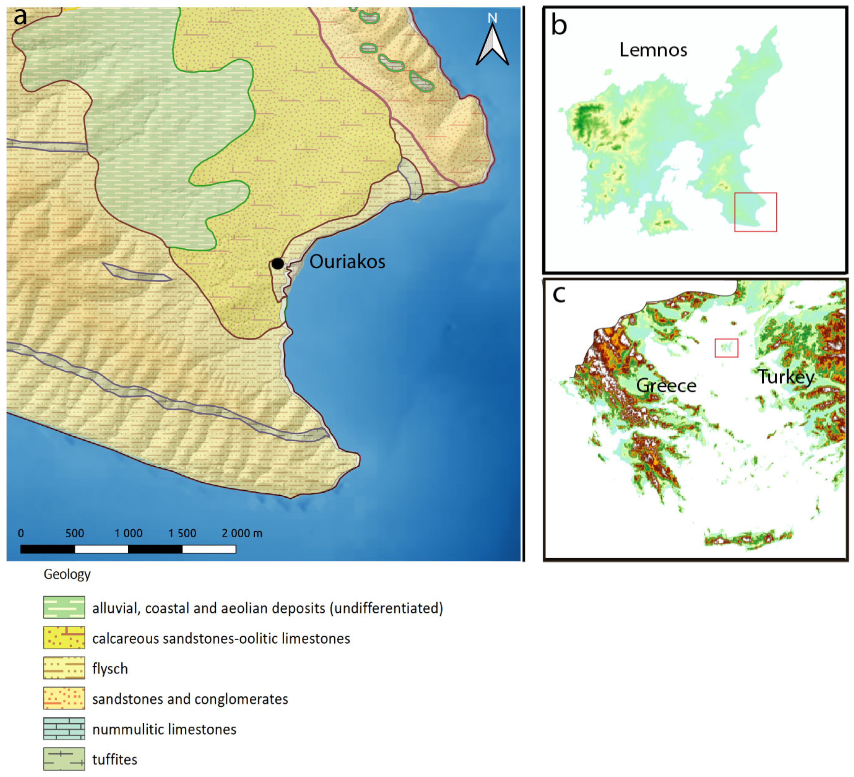
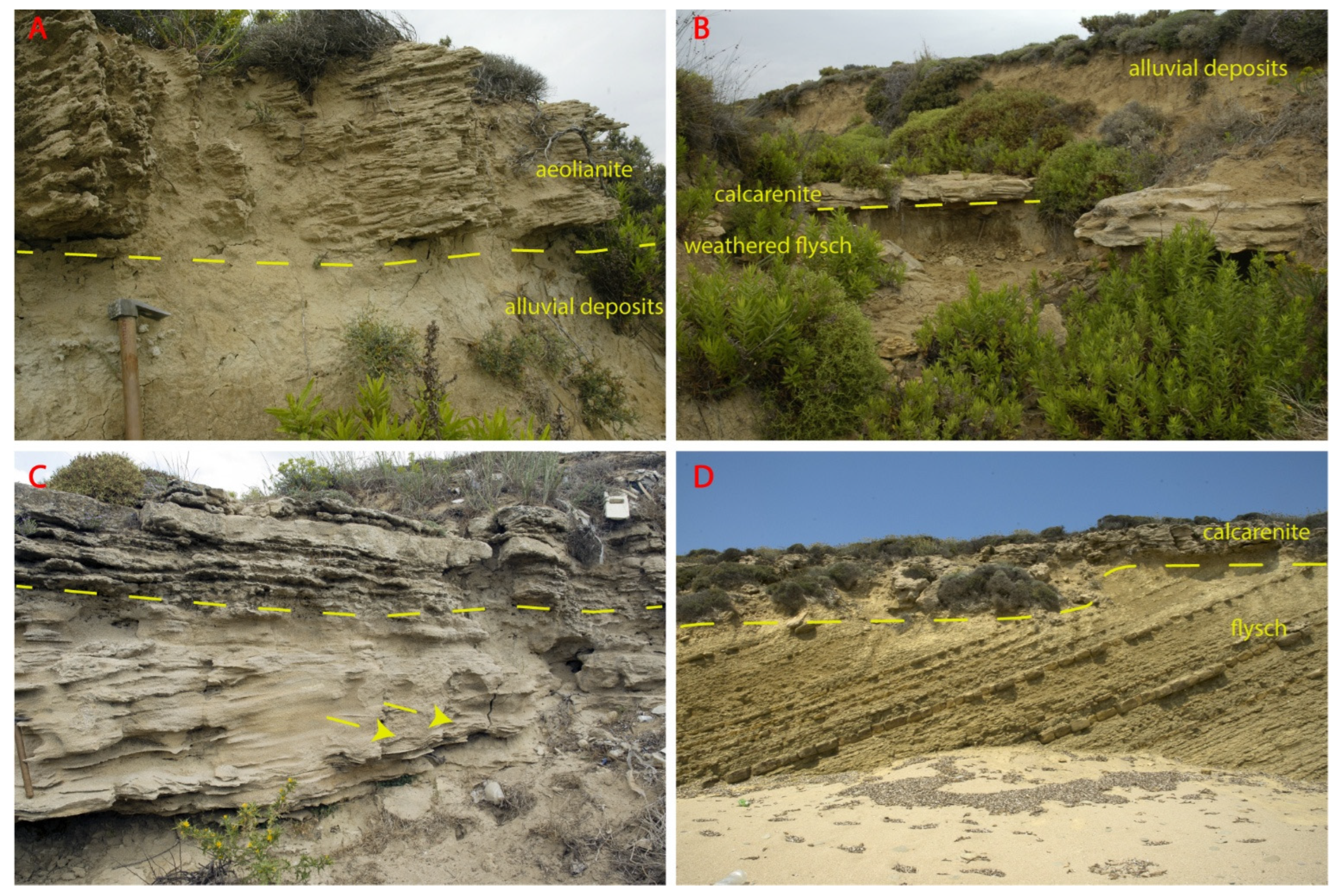
2.2. Geological Setting
3. Materials and Methods
3.1. Bathymetric Study
3.2. Geological and Geomorphological Mapping
3.3. Soil Micromorphology
3.4. Geochemistry
3.5. Luminescence Dating
4. Results
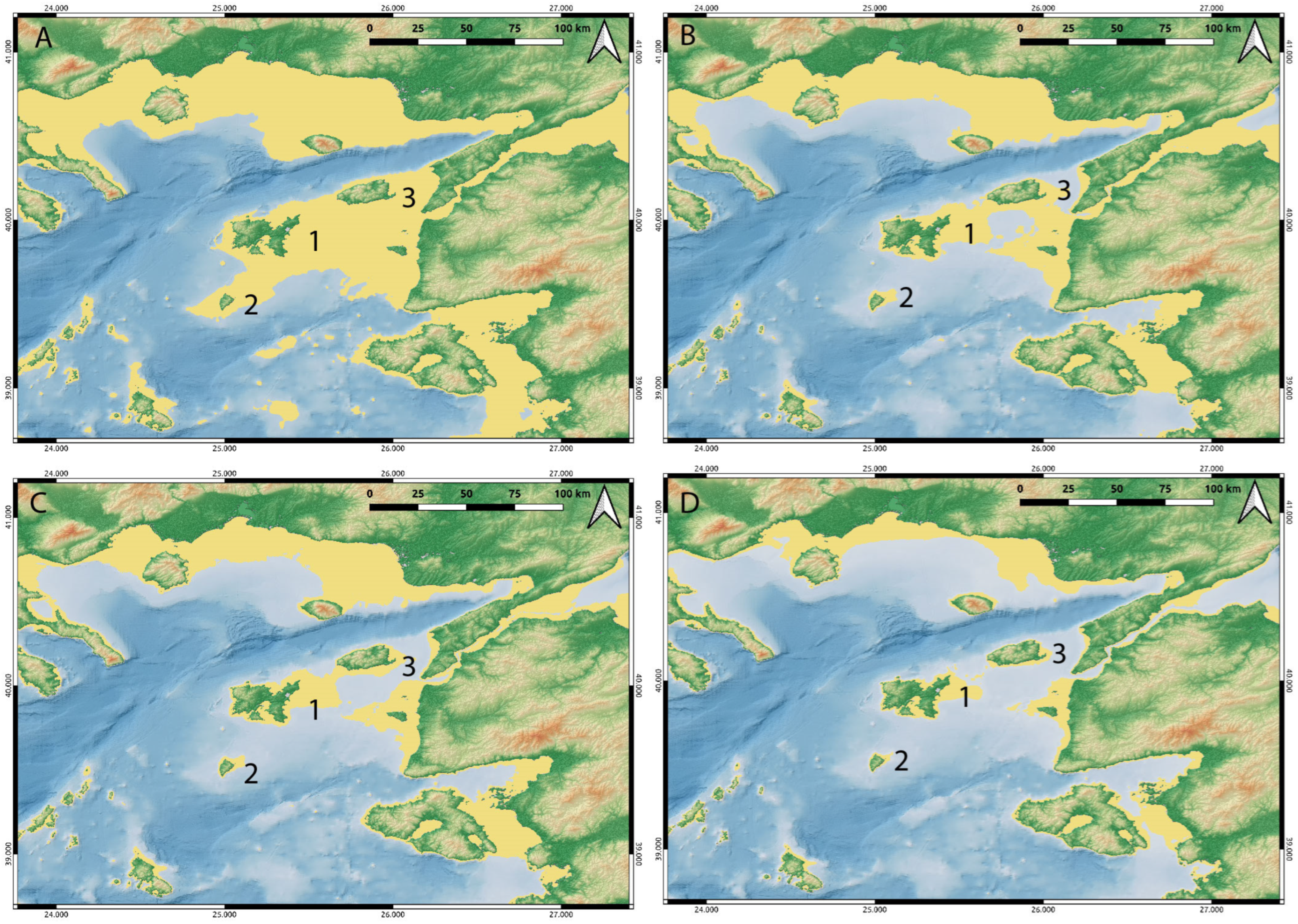
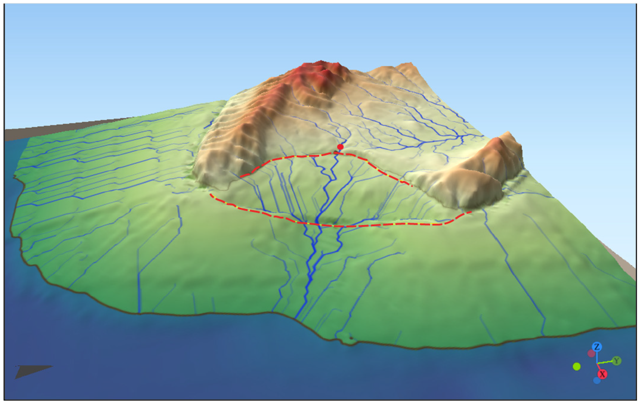
4.1. Bathymetric Study–Paleocoastline Reconstruction
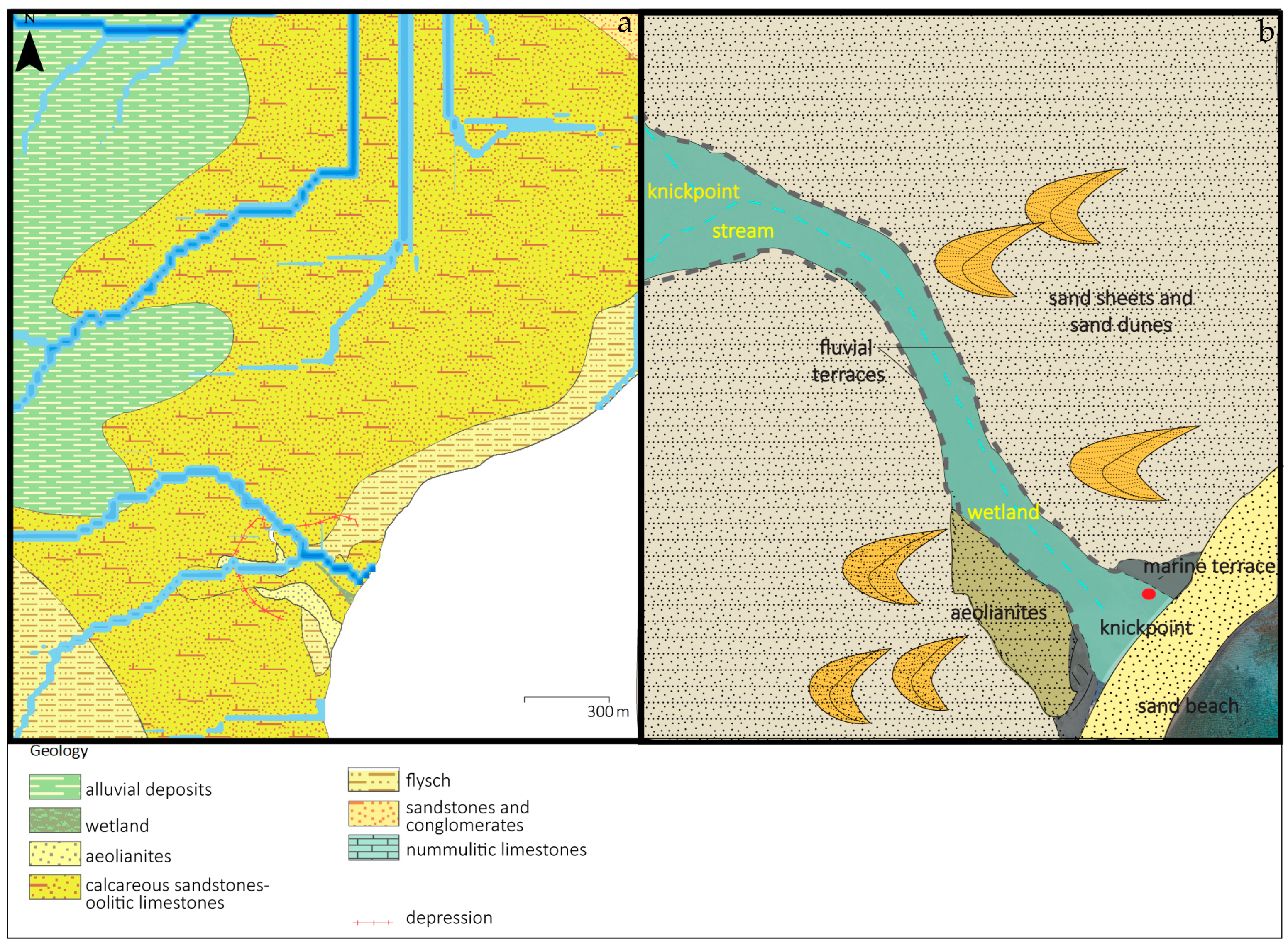
4.2. Geological and Geomorphological Setting
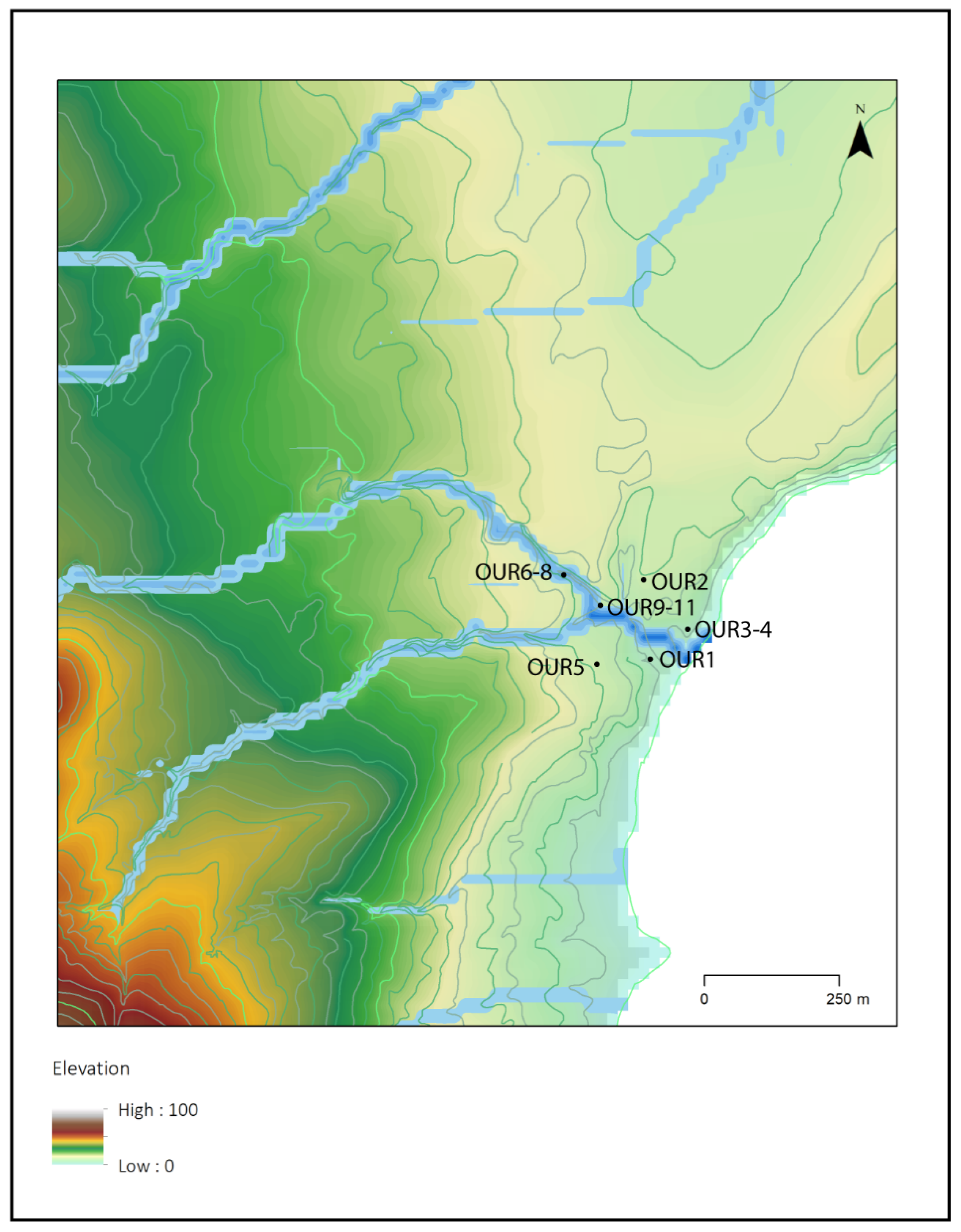
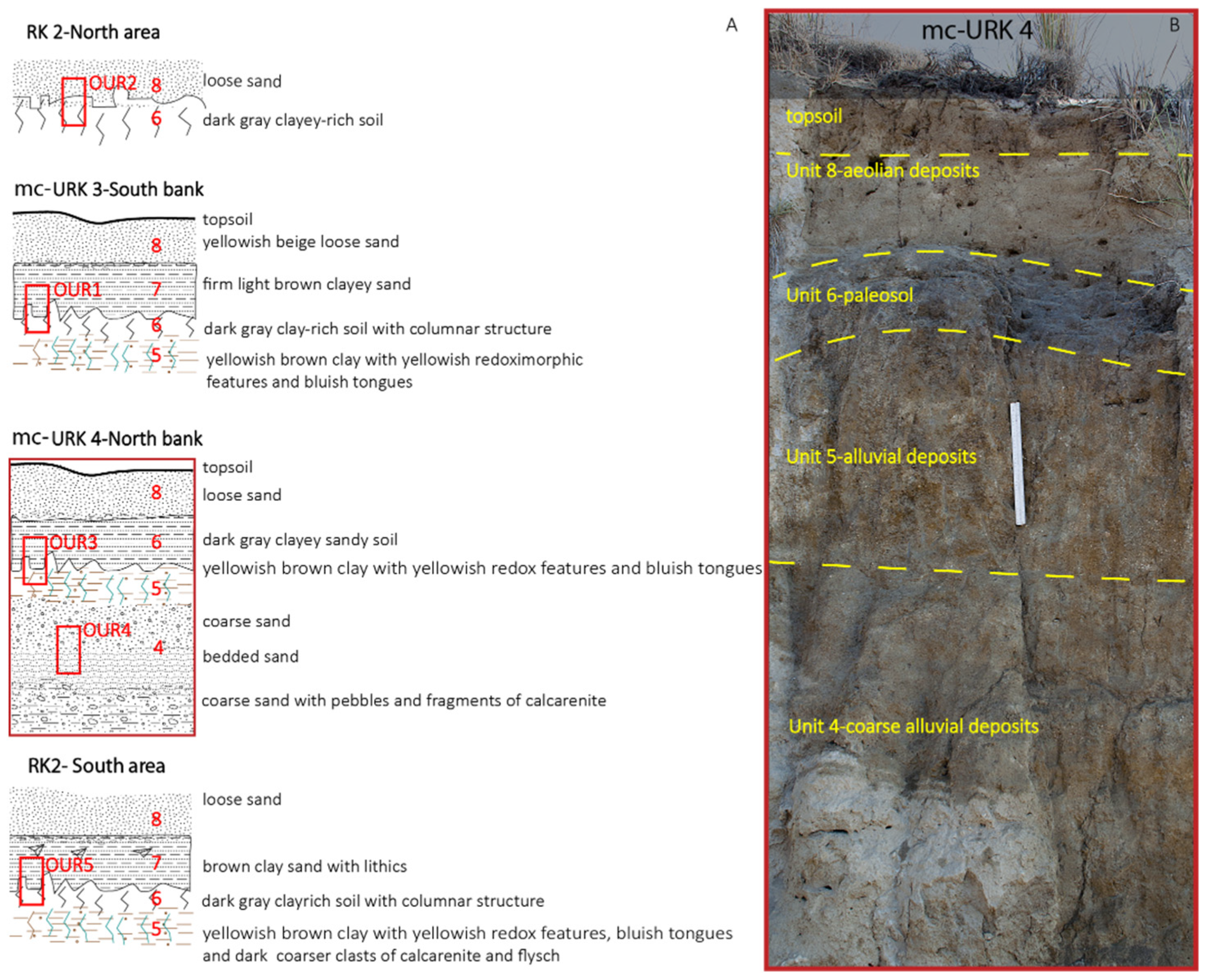
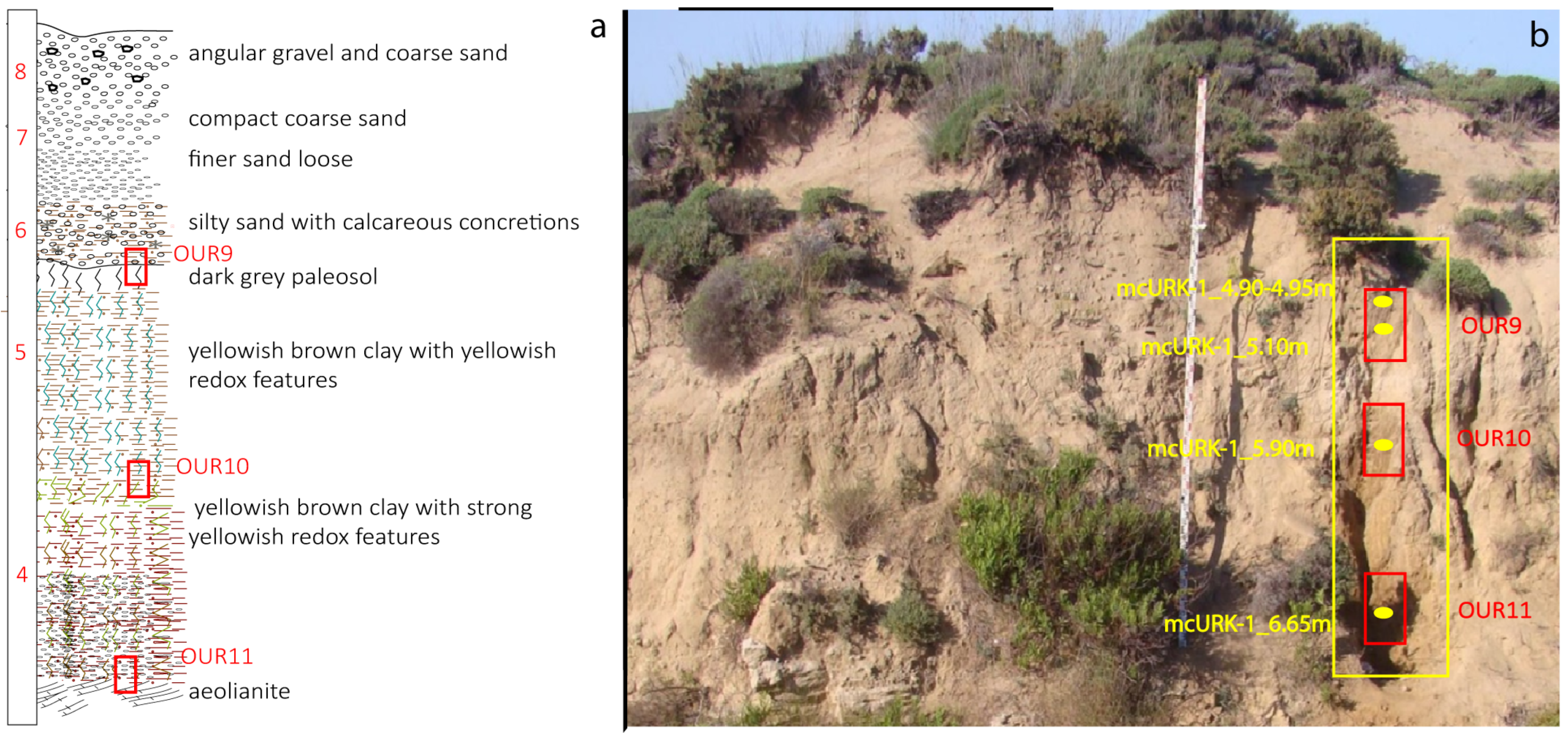
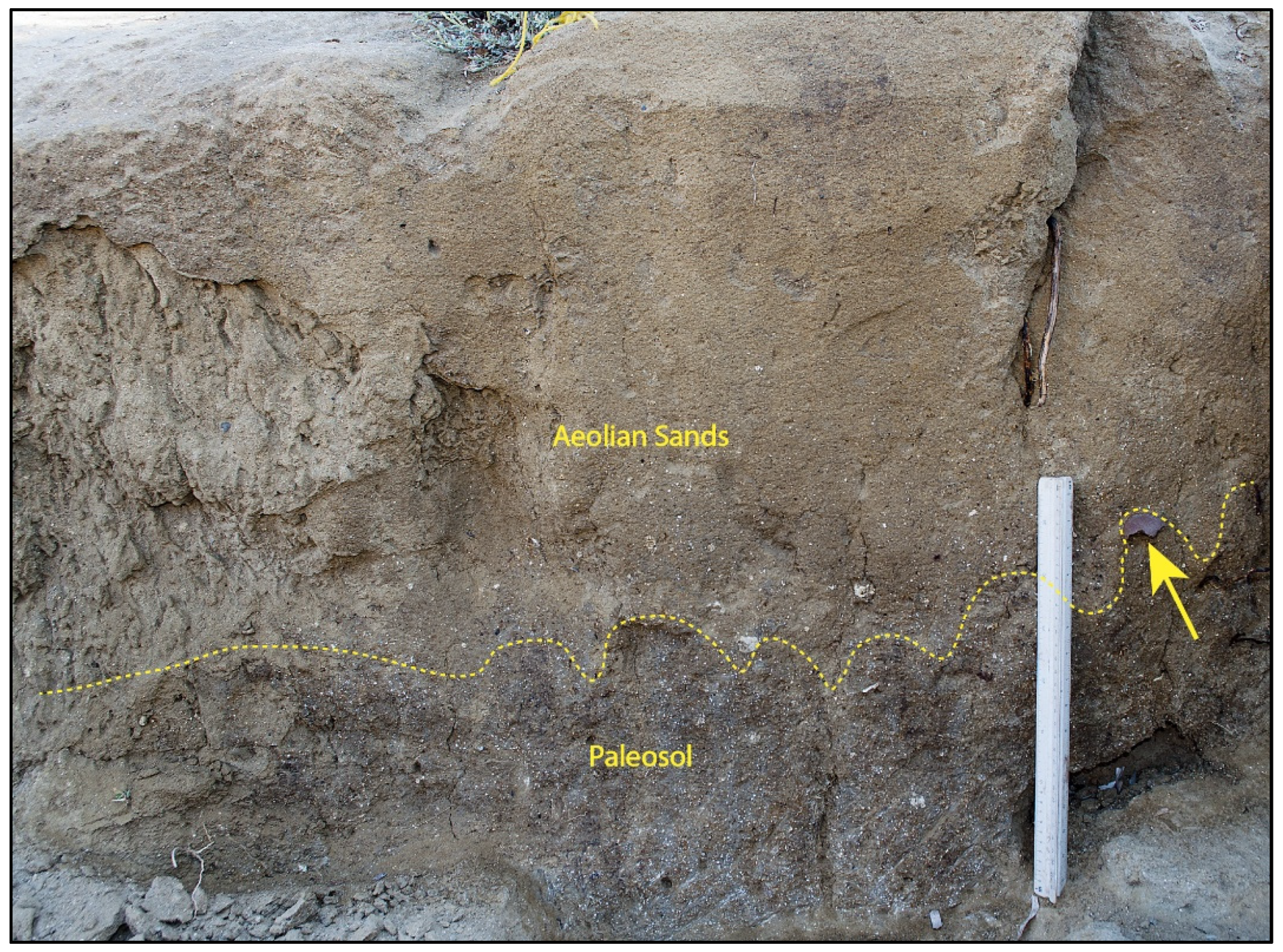
4.3. Stratigraphic Sequence of the Site
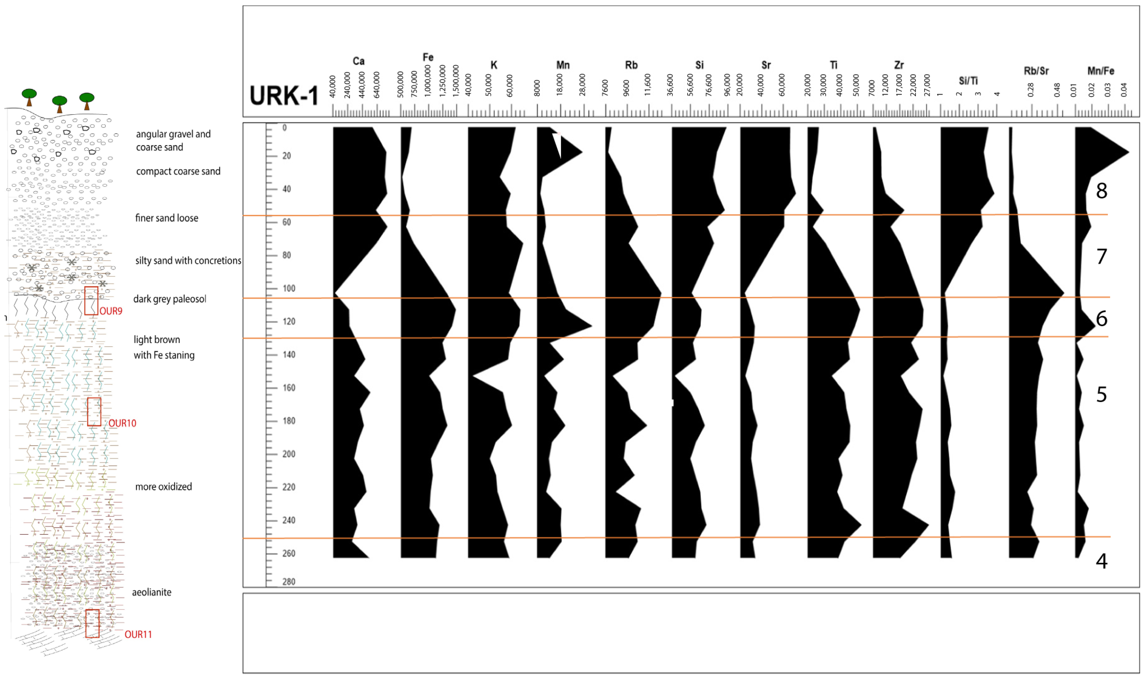
4.4. Geochemistry
4.5. Luminescence Dating
5. Integrated Synthesis of Results
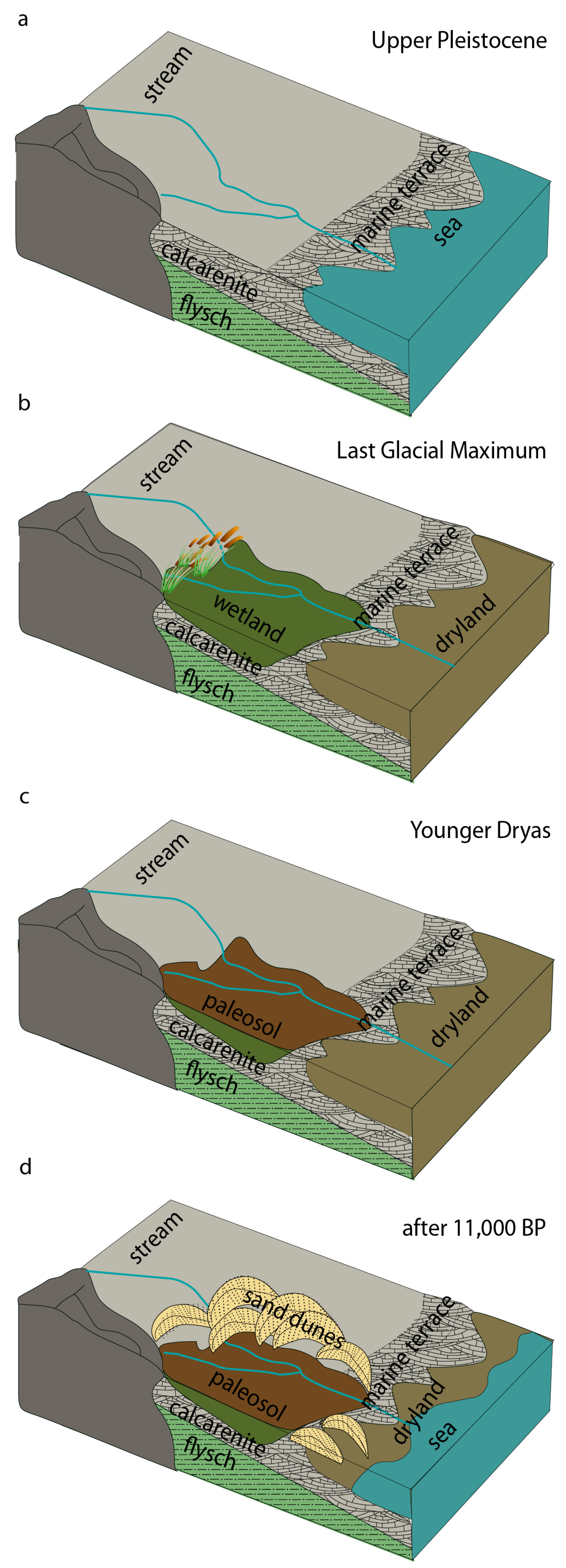
5.1. Paleogeographic Marine and Terrestrial Setting
5.2. The Sedimentary Sequence
6. Discussion
The Formation of the Site
7. Conclusions
Author Contributions
Funding
Data Availability Statement
Acknowledgments
Conflicts of Interest
References
- Çilingiroğlu, Ç.; Kaczanowska, M.; Kozlowski, J.; Dinçer, B.; Çakırlar, C.; Turan, D. Between Anatolia and the Aegean: Epipalaeolithic and Mesolithic Foragers of the Karaburun Peninsula. J. Field Archaeol. 2020, 45, 479–497. [Google Scholar] [CrossRef]
- Kaczanowska, M.; Kozłowski, J.K. The Aegean Mesolithic: Material Culture, Chronology, and Networks of Contact. Eurasian Prehistory 2014, 11, 31–62. [Google Scholar]
- Sampson, A. The Aegean Mesolithic: Environment, Economy and Seafaring. Eurasian Prehistory 2014, 11, 63–74. [Google Scholar]
- Sampson, A. Palaeolithic and Mesolithic Sailors in the Aegean and the Near East; Cambridge Scholars Publishing: Newcastle upon Tyne, UK, 2019. [Google Scholar]
- Ammerman, A.J. Setting Our Sights on the Distant Horizon. In Island Archaeology and the Origins of Seafaring in the Eastern Mediterranean; Ammerman, A.J., Davis, T.W., Eds.; Eurasian Prehistory; University of Oxford: Oxford, UK, 2014; Volume 11, pp. 203–236. [Google Scholar]
- Strasser, T.F.; Panagopoulou, E.; Runnels, C.N.; Murray, P.M.; Thompson, N.; Karkanas, P.; McCoy, F.W.; Wegmann, K.W. Stone Age Seafaring in the Mediterranean: Evidence from the Plakias Region for Lower Palaeolithic and Mesolithic Habitation of Crete. Hesperia 2010, 79, 145–190. [Google Scholar] [CrossRef]
- Carter, T. Obsidian Consumption in the Late Pleistocene–Early Holocene Aegean: Contextualising New Data from Mesolithic Crete. Annu. Br. Sch. Athens 2016, 111, 13–34. [Google Scholar] [CrossRef]
- Chalkioti, A. Reconstructing the Coastal Configuration of Lemnos Island (Northeast Aegean Sea, Greece) since the Last Glacial Maximum. In Géoarchéologie des Îles de Méditerranée; Ghilardi, M., Fachard, S., Léandri, F., Lespez, B., Bressy Leandri, C., Eds.; CNRS Éditions: Paris, France, 2016; pp. 109–118. [Google Scholar]
- Efstratiou, N.; Biagi, P.; Karkanas, P.; Starnini, E. A Late Palaeolithic Site at Ouriakos (Limnos, Greece) in the North-Eastern Aegean. Antiquity 2013, 87, 335. [Google Scholar]
- Efstratiou, N.; Biagi, P.; Starnini, E. The Epipalaeolithic Site of Ouriakos on the Island of Lemnos and Its Place in the Late Pleistocene Peopling of the East Mediterranean Region. Adalya 2014, 17, 1–23. [Google Scholar]
- Efstratiou, N. The Final Palaeolithic Hunting Camp of Ouriakos on the Island of Lemnos. In Island Archaeology and the Origins of Seafaring in the Eastern Mediterranean; Ammerman, A.J., Davis, T.W., Eds.; Eurasian Prehistory; University of Oxford: Oxford, UK, 2014; Volume 11, pp. 75–96. [Google Scholar]
- Erdoğu, B. Géoarchéologie des Îles de La Méditerranée; Ghilardi, M., Ed.; CNRS Éditions: Paris, France, 2016; ISBN 9782271089151. [Google Scholar]
- Erdoğu, B.; Yucel, N.E.; Demir, K. The New Evidence for the Palaeolithic on the Island of Gokceada (Imbros), Northeastern Aegean. J. Lithic Stud. 2021, 8, 1–11. [Google Scholar] [CrossRef]
- Özbek, O.; Erdoğu, B. Initial Occupation of the Gelibolu Peninsula and the Gökçeada (Imbros) Island in the Pre-Neolithic and Early Neolithic. In Island Archaeology and the Origins of Seafaring in the Eastern Mediterranean; Ammerman, A.J., Davis, T.W., Eds.; Eurasian Prehistory; University of Oxford: Oxford, UK, 2014; Volume 11, pp. 97–128. [Google Scholar]
- Sampson, A.; Kaczanowska, M.; Kozlowski, J.K. The Prehistory of the Island of Kythnos (Cyclades, Greece) and the Mesolithic Settlement at Maroulas; Polish Academy of Sciences, University of the Aegean: Kraków, Poland, 2010. [Google Scholar]
- Sampson, A. The Cyclops Cave on the Island of Youra, Greece: Mesolithic and Neolithic Networks in the Northern Aegean Basin; Monograph Series; INSTAP Academic Press: Philadelphia, PA, USA, 2011; Volume 2. [Google Scholar]
- Sampson, A.; Kozłowski, J.K.; Kaczanowska, M. Mesolithic Chipped Stone Industries from the Cave of Cyclope on the Island of Youra (Northern Sporades); British School at Athens Studies: Athens, Greece, 2003; pp. 123–130. [Google Scholar]
- Carter, T.; Contreras, D.A.; Doyle, S.; Mihailović, D.D.; Skarpelis, N. Early Holocene Interaction in the Aegean Islands: Mesolithic Chert Exploitation at Stélida (Naxos, Greece) in Context. In Géoarchéologie des Îles de Méditerranée; Ghilardi, M., Ed.; CNRS Éditions: Paris, France, 2016; pp. 275–286. [Google Scholar]
- Sampson, A. An Extended Mesolithic Settlement in Naxos. Mediterr. Archaeol. Archaeom. 2016, 16, 269. [Google Scholar]
- Sampson, A.; Kaczanowska, M.; Kozłowski, J.K. Mesolithic Occupations and Environments on the Island of Ikaria, Aegean, Greece. Folia Quat. 2012, 80, 5–40. [Google Scholar]
- Sampson, A.; Kaczanowska, M.; Kozłowski, J.K. Kara Pounta on Sikinos: A Settlement of the Mesolithic in the Southern Cyclades. In Proceedings of the 3rd Cycladic International Conference, Hermoupolis, Greece, 25–29 May 2017. [Google Scholar]
- Lambeck, K.; Rouby, H.; Purcell, A.; Sun, Y.; Sambridge, M. Sea Level and Global Ice Volumes from the Last Glacial Maximum to the Holocene. Proc. Natl. Acad. Sci. USA 2014, 111, 15296–15303. [Google Scholar] [CrossRef]
- Bailey, G. Early Seafaring and the Archaeology of Submerged Landscapes. In Eurasian Prehistory: Island Archaeology and the Origins of Seafaring in the Eastern Mediterranean; Peabody Museum Publications: Cambridge, MA, USA, 2014; pp. 99–114. [Google Scholar]
- Tourloukis, V.; Karkanas, P. The Middle Pleistocene Archaeological Record of Greece and the Role of the Aegean in Hominin Dispersals: New Data and Interpretations. Quat. Sci. Rev. 2012, 43, 1–15. [Google Scholar] [CrossRef]
- Galanidou, N.; Dellaporta, K.; Sakellariou, D. Greece: Unstable Landscapes and Underwater Archaeology. In The Archaeology of Europe’s Drowned Landscapes; Bailey, G., Galanidou, N., Peeters, J., Jöns, H., Mennenga, M., Eds.; Springer International Publishing: Cham, Switzerland, 2020; Volume 35, pp. 371–392. [Google Scholar]
- Gkouma, M.; Karkanas, P. The Physical Environment in Northern Greece at the Advent of the Neolithic. Quat. Int. 2018, 496, 14–23. [Google Scholar] [CrossRef]
- IGME. Geological Map of Greece 1:50,000, Sheet Moudros; Geological Mapping by Scientists N. Roussos (1982, 1984, 1987) and A. Katsaounis (1982); IGME: Athens, Greece, 1993. [Google Scholar]
- Pavlopoulos, K.; Fouache, E.; Sidiropoulou, M.; Triantaphyllou, M.; Vouvalidis, K.; Syrides, G.; Gonnet, A.; Greco, E. Palaeoenvironmental Evolution and Sea-Level Changes in the Coastal Area of NE Lemnos Island (Greece) during the Holocene. Quat. Int. 2013, 308–309, 80–88. [Google Scholar] [CrossRef]
- Sakellariou, D.; Galanidou, N. Pleistocene Submerged Landscapes and Palaeolithic Archaeology in the Tectonically Active Aegean Region, in Geology and Archaeology: Submerged Landscapes of the Continental Shelf; Harff, J., Bailey, G.N., Luth, F., Eds.; Special Publications; Geological Society: London, UK, 2016; Volume 411, pp. 145–178. [Google Scholar]
- EMODnet. Available online: https://www.emodnet-bathymetry.eu/media/emodnet_bathymetry/org/documents/press-release-emodnet-bathymetry_jan2021_final.pdf (accessed on 1 January 2021).
- Bullock, P.; Fedoroff, N.; Jongerius, A.; Stoops, G.; Tursina, T. Handbook for Soil Thin Section Description; Waine Research: Wolverhampton, UK, 1985. [Google Scholar]
- Courty, M.A.; Goldberg, P.; Macphail, R. Soils and Micromorphology in Archaeology; Cambridge University Press: Cambridge, UK, 1989. [Google Scholar]
- Stoops, G. Guidelines for Analysis and Description of Soil and Regolith Thin Sections; John Wiley & Sons: Hoboken, NJ, USA, 2021. [Google Scholar]
- Tsakalos, E.; Christodoulakis, J.; Charalambous, L. The Dose Rate Calculator (DRc): A Java Application for Dose Rate and Age Determination Based on Luminescence and ESR Dating. Archaeometry 2016, 58, 347–352. [Google Scholar] [CrossRef]
- Murray, A.S.; Wintle, A.G. The Single Aliquot Regenerative Dose Protocol: Potential for Improvements in Reliability. Radiat. Meas. 2003, 37, 377–381. [Google Scholar] [CrossRef]
- Spooner, N.A. The anomalous fading of infra-red stimulated luminescence from feldspars. Radiat. Meas. 1994, 2, 625–632. [Google Scholar] [CrossRef]
- Wintle, A.G. Anomalous Fading of Thermoluminescence in Mineral Samples. Nature 1973, 245, 143–144. [Google Scholar] [CrossRef]
- Reimann, T.; Tsukamoto, S.; Naumann, M.; Frechen, M. The Potential of Using K-Rich Feldspars for Optical Dating of Young Coastal Sediments—A Test Case from Darss-Zingst Peninsula (Southern Baltic Sea Coast). Quat. Geochronol. 2011, 6, 207–222. [Google Scholar] [CrossRef]
- Buylaert, J.-P.; Murray, A.S.; Huot, S.; Vriend, M.G.A.; Vandenberghe, D.M.; De Corte, F.; Van den Haute, P. A Comparison of Quartz OSL and Isothermal TL Measurements on Chinese Loess. Radiat. Prot. Dosim. 2006, 119, 474–478. [Google Scholar] [CrossRef]
- Auclair, M.; Lamothe, M.; Huot, S. Measurement of Anomalous Fading for Feldspar IRSL Using SAR. Radiat. Meas. 2003, 37, 487–492. [Google Scholar] [CrossRef]
- Huntley, D.J.; Lamothe, M. Ubiquity of Anomalous Fading in K-Feldspars and the Measurement and Correction. Can. J. Earth Sci. 2001, 38, 1093–1106. [Google Scholar] [CrossRef]
- Durand, N.; Monger, C.H.; Canti, M.G. Calcium Carbonate Features. In Interpretation of Micromorphological Features of Soils and Regoliths; Stoops, G., Marcelino, V.Y., Mees, F., Eds.; Elsevier: Amsterdam, The Netherlands, 2010; pp. 149–194. [Google Scholar]
- Yousefifard, M.; Ayoubi, S.; Poch, R.M.; Jalalian, A.; Khademi, H.; Khormali, F. Clay Transformation and Pedogenic Calcite Formation on a Lithosequence of Igneous Rocks in Northwestern Iran. Catena 2015, 133, 186–197. [Google Scholar] [CrossRef]
- Hibbins, S.G. Strontium and Strontium Compounds. Kirk-Othmer Encyclopedia of Chemical Technology; Wiley: Hoboken, NJ, USA, 2002. [Google Scholar] [CrossRef]
- Coradin, T.; Lopez, P.J. Biogenic Silica Patterning: Simple Chemistry or Subtle Biology? ChemBioChem 2003, 4, 251–259. [Google Scholar] [CrossRef] [PubMed]
- Jin, Z.; Cao, J.; Wu, J.; Wang, S. A Rb/Sr Record of Catchment Weathering Response to Holocene Climate Change in Inner Mongolia. Earth Surf. Process. Landf. 2006, 31, 285–291. [Google Scholar] [CrossRef]
- Chawchai, S.; Kylander, M.E.; Chabangborn, A.; Löwemark, L.; Wohlfarth, B. Testing Commonly Used X-ray Fluorescence Core Scanning-Based Proxies for Organic-Rich Lake Sediments and Peat. Boreas 2016, 45, 180–189. [Google Scholar] [CrossRef]
- Fernández, M.; Björck, S.; Wohlfarth, B.; Maidana, N.I.; Unkel, I.; Van der Putten, N. Diatom Assemblage Changes in Lacustrine Sediments from Isla de los Estados, Southernmost South America, in Response to Shifts in the Southwesterly Wind Belt during the Last Deglaciation. J. Paleolimnol. 2013, 50, 433–446. [Google Scholar] [CrossRef]
- Mannella, G.; Giaccio, B.; Zanchetta, G.; Regattieri, E.; Niespolo, E.M.; Pereira, A.; Renne, P.R.; Nomade, S.; Leicher, N.; Perchiazzi, N.; et al. Palaeoenvironmental and Palaeohydrological Variability of Mountain Areas in the Central Mediterranean Region: A 190 ka-Long Chronicle from the Independently Dated Fucino Palaeolake Record (Central Italy). Quat. Sci. Rev. 2019, 210, 190–210. [Google Scholar] [CrossRef]
- Rothwell, R.G.; Croudace, I.W. Micro-XRF Studies of Sediment Cores: A Perspective on Capability and Application in Environmental Sciences. In Micro-XRF Studies of Sediment Cores; Croudace, I.W., Rothwell, R.G., Eds.; Springer: Dordrecht, The Netherlands, 2015; pp. 1–21. [Google Scholar]
- Burn, M.J.; Palmer, S.E. Solar Forcing of Caribbean Drought Events during the Last Millennium. J. Quat. Sci. 2014, 29, 827–836. [Google Scholar] [CrossRef]
- Heymann, C.; Nelle, O.; Dörfler, W.; Zagana, H.; Nowaczyk, N.; Xue, J.; Unkel, I. Late Glacial to Mid-Holocene Palaeoclimate Development of Southern Greece Inferred from the Sediment Sequence of Lake Stymphalia (NE-Peloponnese). Quat. Int. 2013, 302, 42–60. [Google Scholar] [CrossRef]
- Olley, J.; Caitcheon, G.; Murray, A. The Distribution of Apparent Dose as Determined by Optically Stimulated Luminescence in Small Aliquots of Fluvial Quartz: Implications for Dating Young Sediments. Quat. Sci. Rev. 1998, 17, 1033–1040. [Google Scholar] [CrossRef]
- Galbraith, R.F.; Roberts, R.G.; Laslett, G.M.; Yoshida, H.; Olley, J.M. Optical Dating of Single and Multiple Grains of Quartz from Jinmium Rock Shelter, Northern Australia: Part I, Experimental Design and Statistical Models. Archaeometry 1999, 41, 339–364. [Google Scholar] [CrossRef]
- Bilal, A.; Yang, R.; Lenhardt, N.; Han, Z.; Luan, X. The Paleocene Hangu formation: A key to unlocking the mysteries of Paleo-Tethys tectonism. Mar. Pet. Geol. 2024, 157, 106508. [Google Scholar] [CrossRef]
- Roberts, D.L.; Karkanas, P.; Jacobs, Z.; Marean, C.W.; Roberts, R.G. Melting ice sheets 400,000 yr ago raised sea level by 13 m: Past analogue for future trends. Earth Planet. Sci. Lett. 2012, 357, 226–237. [Google Scholar] [CrossRef]
- Koukousioura, O.; Kouli, K.; Gkouma, M.; Theocharidis, N.; Ntinou, M.; Chalkioti, A.; Dimou, V.-G.; Fatourou, E.; Navrozidou, V.; Kafetzidou, A.; et al. Reconstructing the Environmental Conditions in the Prehistoric Coastal Landscape of SE Lemnos Island (Greece) Since the Late Glacial. Water 2025, 17, 220. [Google Scholar] [CrossRef]
- Perissoratis, C.; Conispoliatis, N. The Impacts of Sea-Level Changes during Latest Pleistocene and Holocene Times on the Morphology of the Ionian and Aegean Seas (SE Alpine Europe). Mar. Geol. 2003, 196, 145–156. [Google Scholar] [CrossRef]
- Lambeck, K.; Purcell, A. Sea-Level Change in the Mediterranean Sea since the LGM: Model Predictions for Tectonically Stable Areas. Quat. Sci. Rev. 2005, 24, 1969–1988. [Google Scholar] [CrossRef]
- Pavlopoulos, K. Relative Sea Level Fluctuations in Aegean Coastal Areas from Middle to Late Holocene. Geodin. Acta 2010, 23, 225–232. [Google Scholar] [CrossRef]
- Pavlopoulos, K.; Kapsimalis, V.; Theodorakopoulou, K.; Panagiotopoulos, I.P. Vertical Displacement Trends in the Aegean Coastal Zone (NE Mediterranean) during the Holocene Assessed by Geo-Archaeological Data. Holocene 2011, 22, 717–728. [Google Scholar] [CrossRef]
- Seeliger, M.; Pint, A.; Frenzel, P.; Marriner, N.; Spada, G.; Vacchi, M.; Basaran, S.; Dan, A.; Seeger, F.; Seeger, K.; et al. Mid-to Late-Holocene Sea-Level Evolution of the Northeastern Aegean Sea. Holocene 2021, 31, 1621–1634. [Google Scholar] [CrossRef]
- McHugh, C.M.; Gurung, D.; Giosan, L.; Ryan, W.B.; Mart, Y.; Sancar, U.; Burckle, L.H.; Cagatay, M.N. The Last Reconnection of the Marmara Sea (Turkey) to the World Ocean: A Paleoceanographic and Paleoclimatic Perspective. Mar. Geol. 2008, 255, 64–82. [Google Scholar] [CrossRef]
- Broodbank, C. The Origins and Early Development of Mediterranean Maritime Activity. J. Mediterr. Archaeol. 2006, 19, 199. [Google Scholar] [CrossRef]

| Step | Treatment |
|---|---|
| 1 | Give dose |
| 2 | Preheat, 10 s at 240 °C |
| 3 | Blue LED stimulation, 40 s at 125 °C |
| 4 | Give test dose |
| 5 | Cut-heat, 0 s at 200 °C |
| 6 | Blue LED stimulation, 40 s at 125 °C |
| 7 | IR diode stimulation, 100 s at 125 °C |
| 8 | Return to Step 1 |
| Step | Treatment |
|---|---|
| 1 | Give dose |
| 2 | Preheat, 60 s at 180 °C |
| 3 | IR stimulation, 100 s at 50 °C |
| 4 | IR stimulation, 100 s at 160 °C |
| 5 | Give test dose |
| 6 | Cut heat, 60 s at 180 °C |
| 7 | IR stimulation, 100 s at 50 °C |
| 8 | IR stimulation, 100 s at 160 °C |
| 9 | IR stimulation, 40 s at 325 °C |
| 10 | Return to Step 1 |
| Sample ID | U (ppm) | Th (ppm) | K (wt %) | Rb (ppm) | Water (wt%) | Total Dose Rate (Gy/ka) |
|---|---|---|---|---|---|---|
| Ext. | Ext. | Ext. | Ext. | |||
| URK-1 (4.90–4.95) | 0.9 | 4.2 | 1.28 | 51.6 | 2.51 | 1.91 ± 0.12 |
| URK-1 (5.10) | 1.3 | 7.2 | 1.68 | 70.7 | 6.7 | 2.52 ± 0.14 |
| URK-1 (5.90) | 1.3 | 6.4 | 1.46 | 69.2 | 6.94 | 2.24 ± 0.12 |
| URK-1 (6.65) | 1.2 | 6.5 | 1.41 | 62.3 | 5.83 | 2.21 ± 0.12 |
| Unit No. | Macroscopic Description | Microscopic Description | Interpretation | Sample No. |
|---|---|---|---|---|
| Unit 1 | Yellowish–green clay | Yellowish–green clay with elongated vughs and voids due to bioturbation and aggregates of cemented mudstone | Weathered flysch | OUR6 |
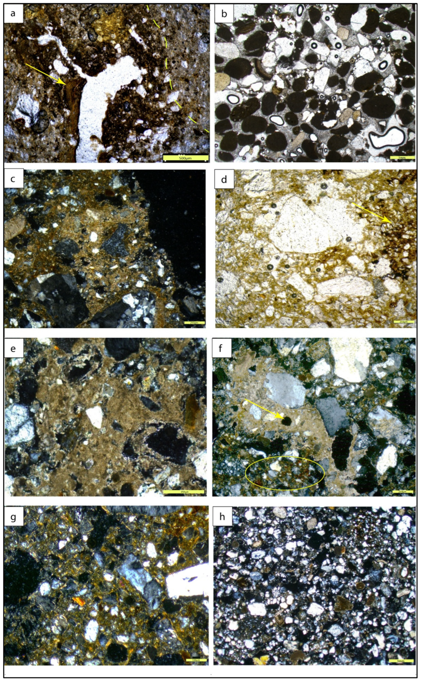
| Units 2–3 | Coarse and fine sands in (a) cross bedding and climbing ripples; (b) thin horizontal bedding with fine and coarse couplets | Sands cemented in a calcareous matrix with oolites, peloids, foraminifera, and shells in coarse (1 mm) (Unit 2) and fine laminations (0.5 mm) (Unit 3) | Calcarenite (coastal marine deposits) | OUR7 and OUR8 |
| Unit 4 | Coarse silty sands | Fine and locally coarse, well sorted, subrounded sands and calcarenite fragments in a silty clay matrix with oxidized staining, few calcareous aggregates, crystallitic infillings, and illuviation features | Transitional alluvial deposits with eroded calcarenite fragments | OUR4 and OUR11 |
| Unit 5 | Yellowish–brown clays with strong brown redoximorphic features and intercalating bluish tongues | Yellowish–brown clays with impregnation redoximorphic features, rounded fragments of sandstone, few rounded calcareous nodules, and a vughy microstructure with crystallitic infillings and shells fragments | Alluvial deposits with indications of a fluctuating water table | OUR3 and OUR10 |
| Unit 6a | Dark-gray soil with blocky microstructure | Decalcified sandy loam–sandy silt loam, cross-striated clays, speckled Fe/Mn impregnations, sporadic calcareous infillings, channels with calcite-impregnated roots (queras), bioturbation features, and more oxidization in the lower part of the unit | Exposure-weak soil formation | OUR1 OUR2, OUR3 and OUR9 |
| Unit 6b | In undulating boundary to Unit 8 | Sand infiltration from Unit 7, fragments of calcarenite, and abundant calcareous infillings | Truncated paleosol/bioturbation/aeolian processes | OUR2 |
| Unit 6c | In the south area, RK3, lithics are recorded on top of the unit | Oxidized sandy silt loam with extended calcareous infillings, calcarenite sand grains, abundant oolites, oxidation staining, a bone fragment at the bottom, and queras at the upper part | Reworked paleosol | OUR5 |
| Unit 7 | Firm sands | Moderately sorted loamy sand, cross-striated/crystallitic b/f fabric, subrounded to subangular 250–500 μm quartz, quartzite, calcite, olivine, calcareous and crystallitic coatings cementing the matrix, redoximorphic features, and a granular structure with many voids | Colluvial and/or aeolian? The cementation is probably due to vadose processes | OUR1, OUR5 and 9 |
| Unit 8a | Finely bedded to laminated, well sorted sands cemented with calcite | Aeolianites | south bank | |
| Unit 8b | Loose sands | Silty sands in a granular microstructure; moderately sorted, abundant oolites, quartz, and calcite; sandstone (aeolianite); abundant foraminifera; and fragments of calcarenite | Aeolian, reworked | OUR2 |
| Sample ID | Material | Number of Aliquots | Dose Rate (Gy/ka) | Age (ka) * | |
|---|---|---|---|---|---|
| mc-URK1_4.90–4.95 | Feldspar | 11 | 1.91 ± 0.12 | 13.78 ± 0.88 | 13.35 ± 0.94 |
| mc-URK1 (5.10) | Feldspar | 12 | 2.52 ± 0.14 | 14.08 ± 0.84 | 13.73 ± 0.78 |
| mc-URK1_5.90 | Feldspar | 10 | 2.24 ± 0.12 | 32.96 ± 2.3 | 26.79 ± 2.02 |
| mc-URK1_6.65 | Feldspar | 12 | 2.21 ± 0.12 | 29.82 ± 2.26 | 25.35 ± 1.45 |
Disclaimer/Publisher’s Note: The statements, opinions and data contained in all publications are solely those of the individual author(s) and contributor(s) and not of MDPI and/or the editor(s). MDPI and/or the editor(s) disclaim responsibility for any injury to people or property resulting from any ideas, methods, instructions or products referred to in the content. |
© 2025 by the authors. Licensee MDPI, Basel, Switzerland. This article is an open access article distributed under the terms and conditions of the Creative Commons Attribution (CC BY) license (https://creativecommons.org/licenses/by/4.0/).
Share and Cite
Gkouma, M.; Karkanas, P.; Koukousioura, O.; Syrides, G.; Chalkioti, A.; Tsakalos, E.; Ntinou, M.; Efstratiou, N. Exploring Continental and Submerged Paleolandscapes at the Pre-Neolithic Site of Ouriakos, Lemnos Island, Northeastern Aegean, Greece. Quaternary 2025, 8, 42. https://doi.org/10.3390/quat8030042
Gkouma M, Karkanas P, Koukousioura O, Syrides G, Chalkioti A, Tsakalos E, Ntinou M, Efstratiou N. Exploring Continental and Submerged Paleolandscapes at the Pre-Neolithic Site of Ouriakos, Lemnos Island, Northeastern Aegean, Greece. Quaternary. 2025; 8(3):42. https://doi.org/10.3390/quat8030042
Chicago/Turabian StyleGkouma, Myrsini, Panagiotis Karkanas, Olga Koukousioura, George Syrides, Areti Chalkioti, Evangelos Tsakalos, Maria Ntinou, and Nikos Efstratiou. 2025. "Exploring Continental and Submerged Paleolandscapes at the Pre-Neolithic Site of Ouriakos, Lemnos Island, Northeastern Aegean, Greece" Quaternary 8, no. 3: 42. https://doi.org/10.3390/quat8030042
APA StyleGkouma, M., Karkanas, P., Koukousioura, O., Syrides, G., Chalkioti, A., Tsakalos, E., Ntinou, M., & Efstratiou, N. (2025). Exploring Continental and Submerged Paleolandscapes at the Pre-Neolithic Site of Ouriakos, Lemnos Island, Northeastern Aegean, Greece. Quaternary, 8(3), 42. https://doi.org/10.3390/quat8030042