

Upper Pleistocene Marine Levels of the Es Copinar–Es Estufadors (Formentera, Balearic Islands, West Mediterranean)


Abstract
1. Introduction
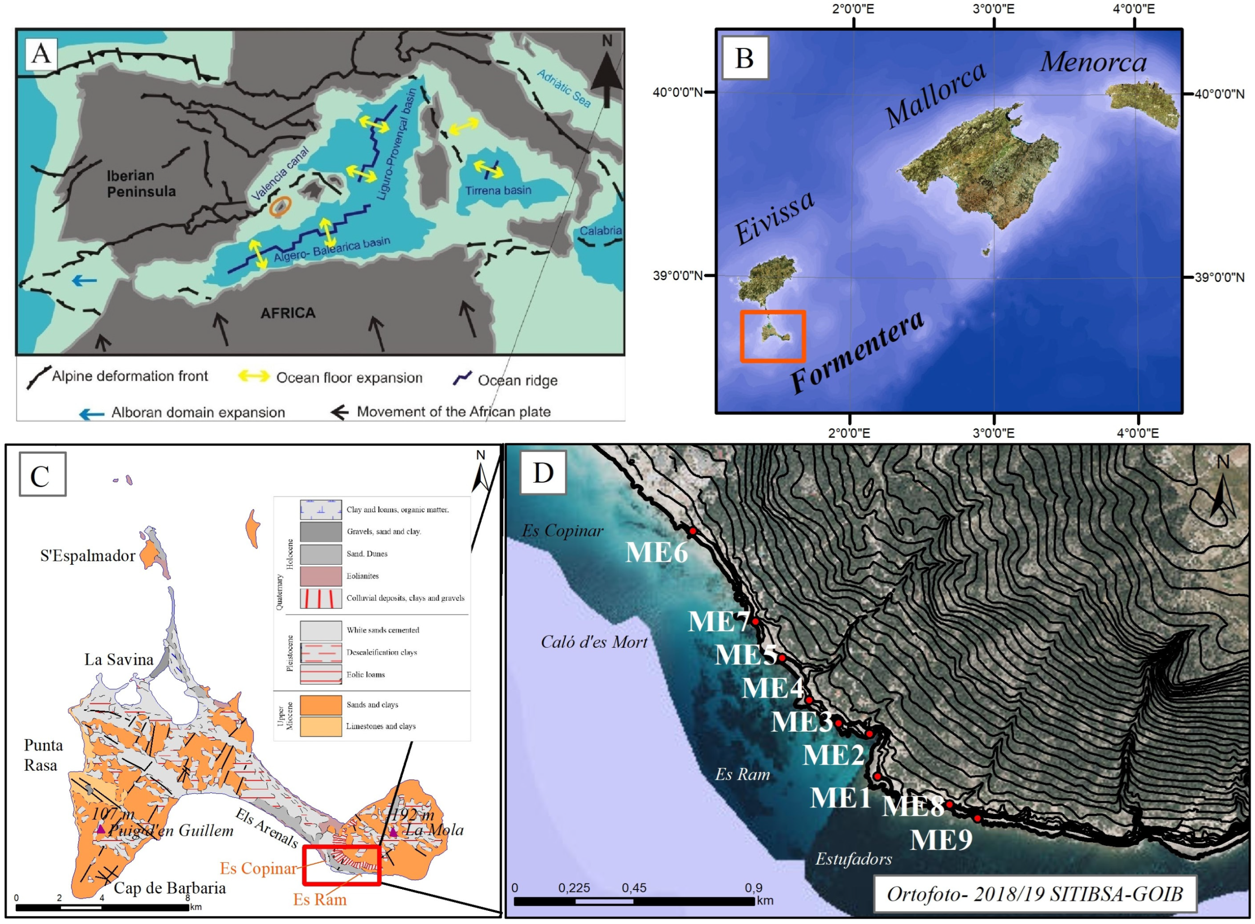
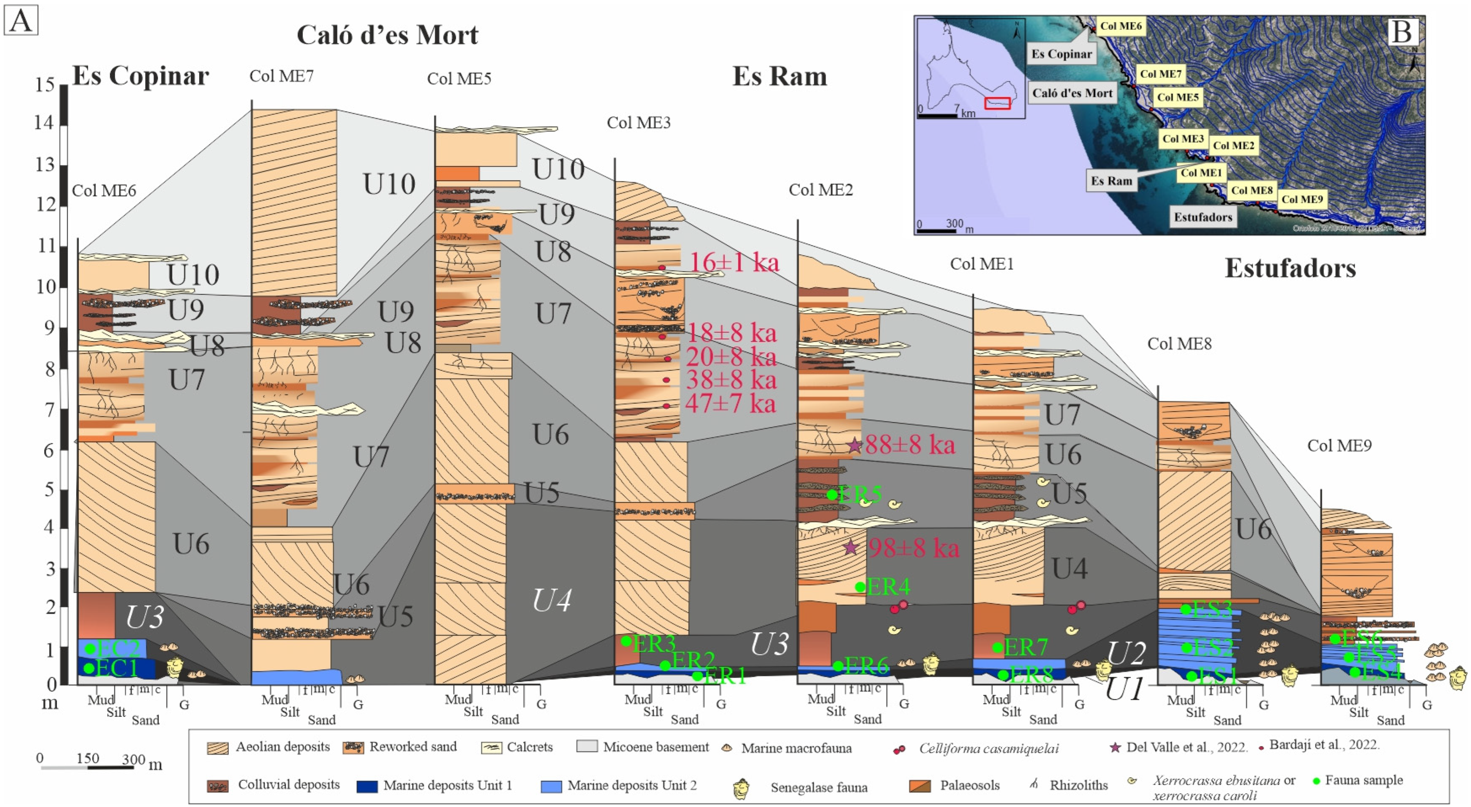
1.1. Geological and Physiographical Setting
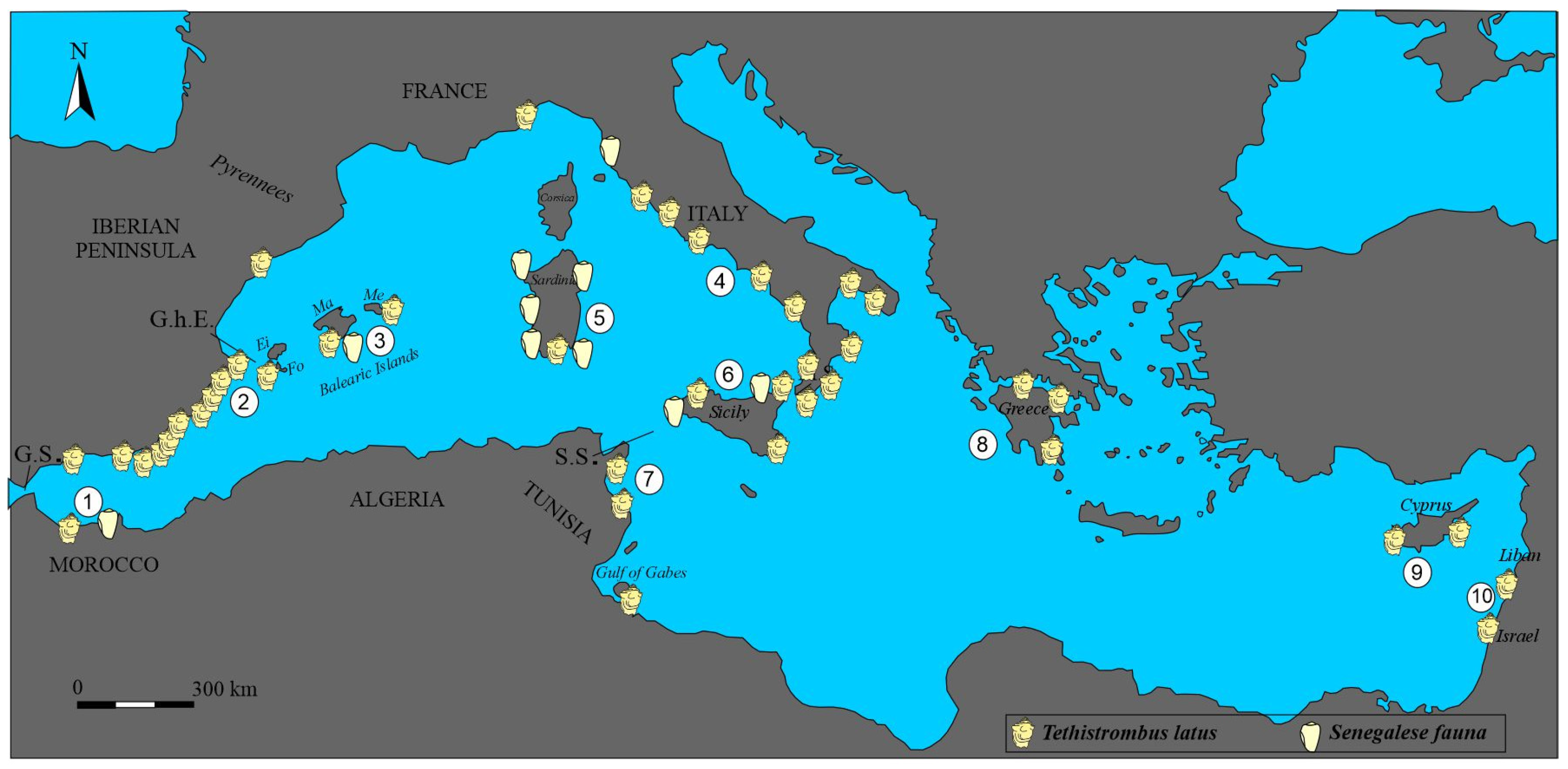
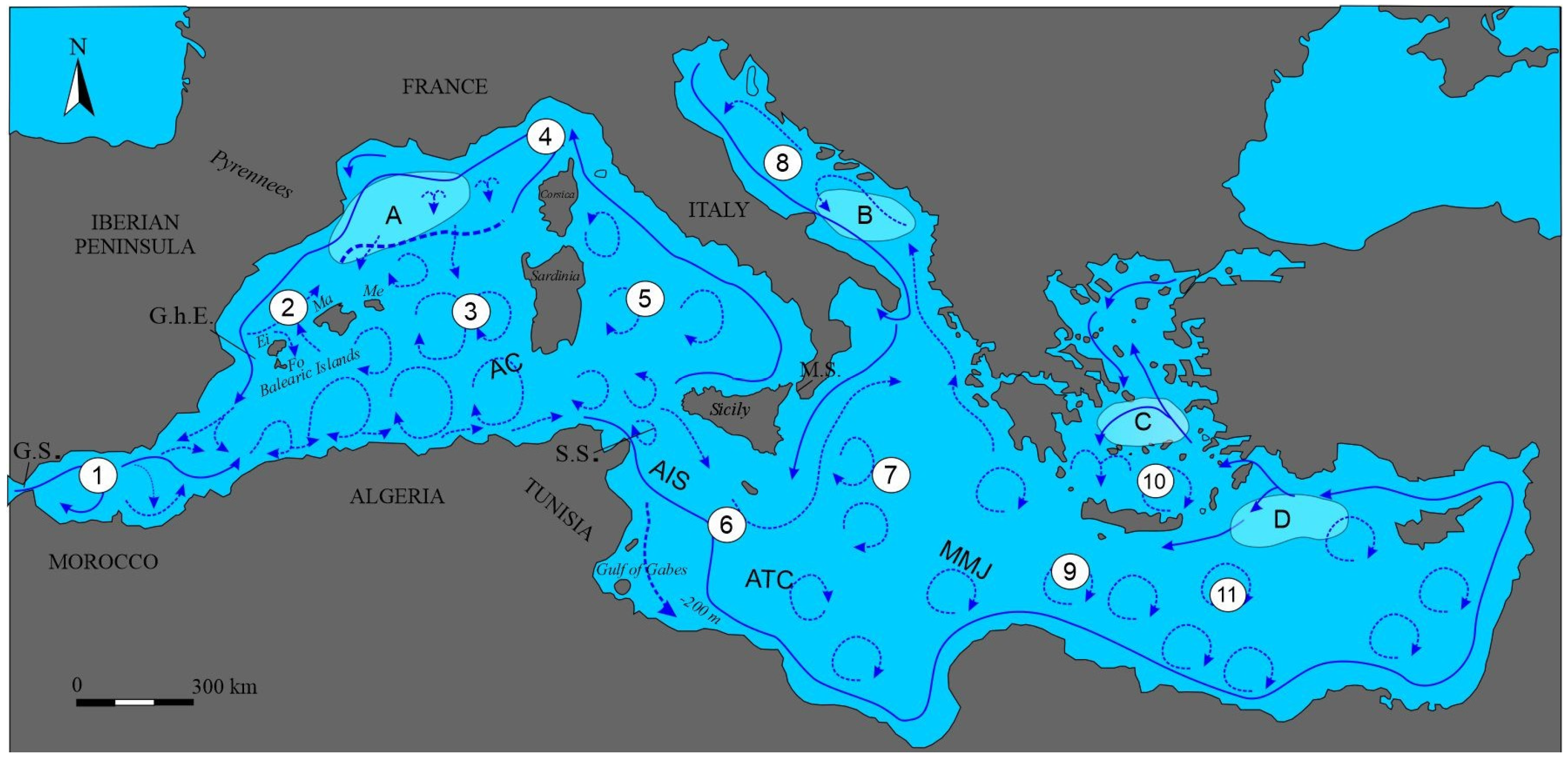
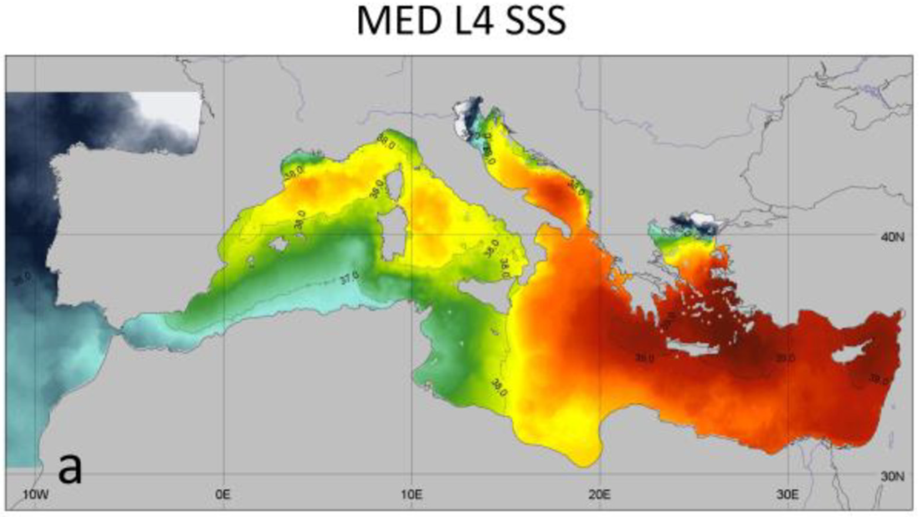
1.2. Mediterranean Water Circulation
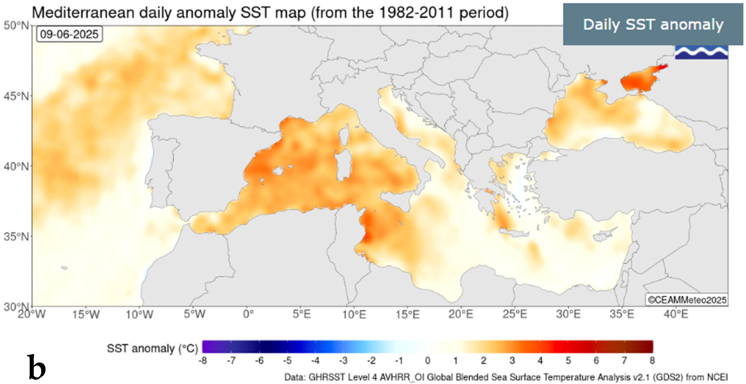
1.3. Present Meteorological Conditions
2. Materials and Methods
3. Results
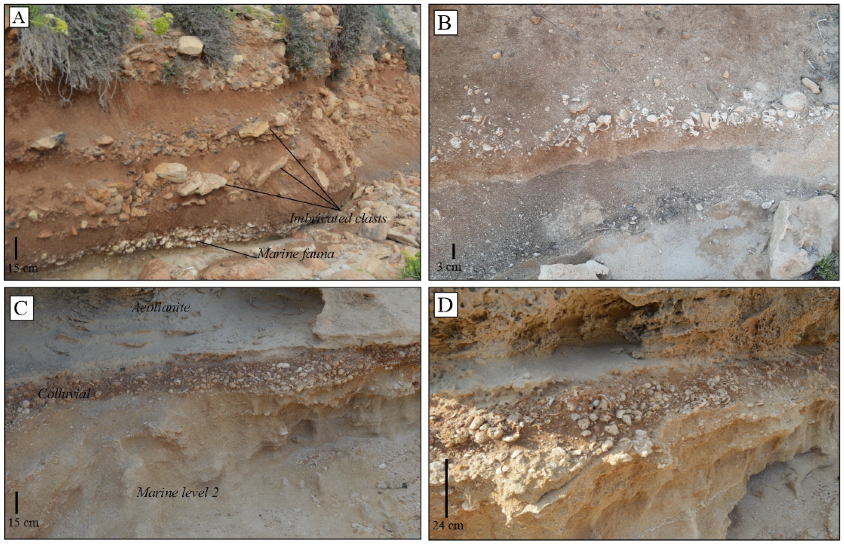
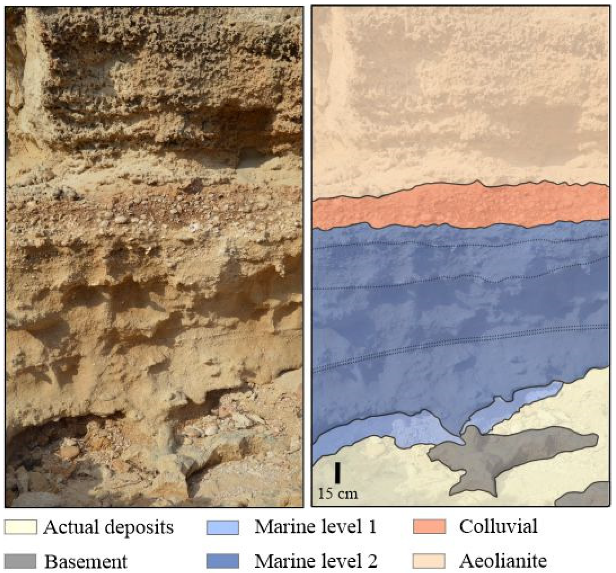
3.1. Marine Facies
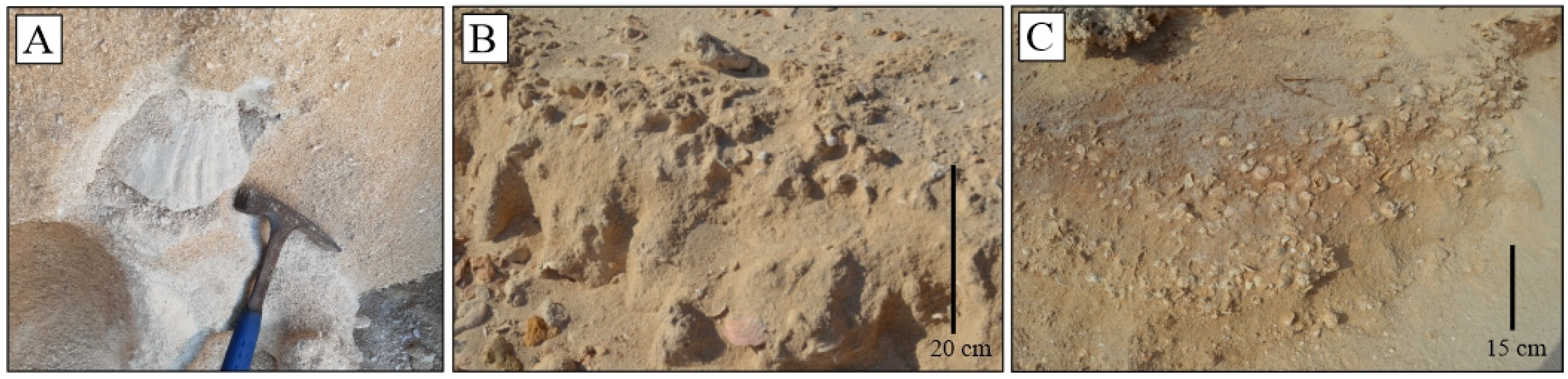
3.1.1. Sandy Beach
Description
Interpretation
3.2. Colluvial Facies Association
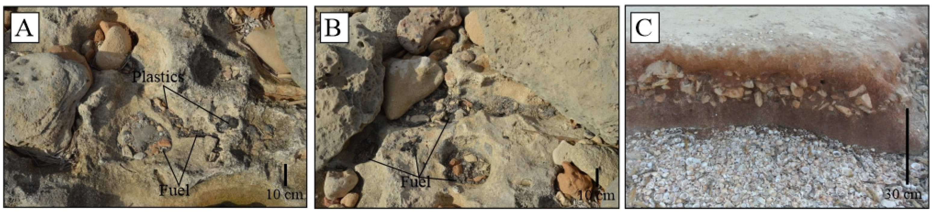
3.2.1. Silty-Breccia with Marine Shells and Palaeosols
Description
Interpretation
4. Discussion
5. Conclusions
Author Contributions
Funding
Data Availability Statement
Acknowledgments
Conflicts of Interest
References
- Murray-Wallace, C.V.; Woodroffe, C.D. The causes of Quaternary sea-level changes. In Quaternary Sea-Level Changes: A Global Perspective; Cambridge University Press: Cambridge, UK, 2014; pp. 41–78. [Google Scholar]
- Zazo, C.; Goy, J.L.; Hillaire-Marcel, C.; Dabrio, C.J.; González-Delgado, J.A.; Cabero, A.; Bardají, T.; Ghaleb, B.; Soler, V. Sea level changes during the last and present interglacials in Sal Island (Cape Verde archipelago). Glob. Planet. Change 2010, 72, 302–317. [Google Scholar] [CrossRef]
- Vicens, D. El Registre Paleontològic Dels Dipòsits Litorals Quaternaris a l’illa de Mallorca (Illes Balears, Mediterrània Occidental). Ph.D. Thesis, University of the Balearic Islands, Palma, Spain, 2015; p. 1011. [Google Scholar]
- Martínez-Ruiz, F.; Kastner, M.; Gallego-Torres, D.; Rodrigo-Gámiz, M.; Nieto-Moreno, V.; Ortega-Huertas, M. Paleoclimate and paleoceonography over the past 20,000 yr in the Mediterranean Sea Basins as indicated by sediment elemental proxies. Quat. Sci. Rev. 2015, 107, 25–46. [Google Scholar] [CrossRef]
- Zazo, C.; Goy, J.L.; Dabrio, C.J.; Lario, J.; González-Delgado, J.A.; Bardají, T.; Hillaire-Marcel, C.; Cabero, A.; Ghaleb, B.; Borja, F.; et al. Retracing the Quaternary history of sea-level changes in the Spanish Mediterranean-Atlantic coasts: Geomorphological and sedimentological approach. Geomorphology 2013, 196, 36–49. [Google Scholar] [CrossRef]
- Costa, M.; Cuerda, J.; Rosselló, V.M. Formentera i els estanys. Panorama geològic des del Quaternari. Cuad. Geogr. 1985, 37, 75–96. [Google Scholar]
- Somoza, L.; Medialdea, T.; Terrinha, P.; Ramos, A.; Vázquez, J.T. Submarine Active Faults and Morpho-Tectonics Around the Iberian Margins: Seismic and Tsunamis Hazards. Front. Earth Sci. 2021, 9, 653639. [Google Scholar] [CrossRef]
- Bardají, T.; Roquero, E.; Cabero, A.; Zazo, C.; Goy, J.L.; Dabrio, C.J.; Machado, M.J.; Lario, J.; Silva, P.G.; Martínez-Graña, A.M. Abrupt environmental changes during the last glacial cycle in Western Mediterranean (Formentera Island, Balearic archipelago). Quat. Int. 2022, 638–639, 159–179. [Google Scholar] [CrossRef]
- Gàsser, Z. Descripció del jaciment del Miocè marí a s’estufador (Formentera, Illes Pitiüses, Mediterrània occidental). Boll. Soc. Hist. Nat. Balears 2001, 44, 87–92. [Google Scholar]
- Gàsser, Z. Jaciments paleontològics marins del Miocè i Quaternari d’es Ram (Formentera, Illes Pitiüses). Boll. Soc. Hist. Nat. Balears 2002, 45, 87–92. [Google Scholar]
- Butzer, K.W.; Cuerda, J. Coastal stratigraphy of southern Mallorca and its implication for the Pleistocene chronology of the Mediterranean Sea. J. Geol. 1962, 70, 398–416. [Google Scholar] [CrossRef]
- Cuerda, J. A Contribution to the Knowledge of Pleistocene Coastal Profiles. In Biogeography and Ecology of the Pityusic Islands; Kuhbier, H., Alcover, J.A., Guerau d’Arellano, C., Eds.; Monographiae Biologicae; Springer: The Hague, The Netherlands, 1984; Volume 52, pp. 105–118. [Google Scholar]
- Cuerda, J. Moluscos Marinos y Salobres Del Pleistoceno Balear; La Caja de Baleares “Sa Nostra”: Palma, Spain, 1987; p. 421. [Google Scholar]
- Cuerda, J. Los Tiempos Cuaternarios en Baleares, 2nd ed.; Conselleria de Cultura, Educació i Esports del Govern Balear: Palma, Spain, 1989; p. 305. [Google Scholar]
- Gàsser, Z.; Ferrer, J.A. Nous jaciments paleontològics del Miocè i Quaternari de Formentera (Illes Pitiüses, Mediterrània Occidental). In Bolletí de la Societat d’Història Natural de les Balears; Societat d’Història Natural de les Balears: Palma de Mallorca, Spain, 1997; Volume 40, pp. 91–101. ISSN 212-260X. [Google Scholar]
- Gàsser, Z. Nota paleontològica sobre el jaciment quaternari marí d’Es Copinar (Formentera, Illes Pitiüses, Mediterrània occidental). Boll. Soc. Hist. Nat. Balears 1998, 41, 153–157. [Google Scholar]
- Bardají, T.; Cabrero, A.; Roquero, E.; Zazo, C.; Lario, J.; Dabrio, C.J.; Goy, J.L.; Machado, M.J.; Mercier, N.; Silva, P.G.; et al. Climatic variability in western Mediterranean during the last glacial cycle (ca. 130–114 ky BP): Evidences from an island setting (Formentera, Balearic Is., Spain). In Proceedings of the PAGES 5th Open Science Meeting, Zaragoza, Spain, 9–13 May 2017. [Google Scholar]
- Del Valle, L.; Timar-Gabor, A.; Fornós, J.J. Late Pleistocene Coastal Deposits of South-Western Formentera (Western Mediterranean): Chronology, Landscape Evolution and Climatic Variability. In Proceedings of the IAS Conference, Rome, Italy, 10–13 September 2019. [Google Scholar]
- Del Valle, L.; Timar-Gabor, A.; Pomar, F.; Pons, G.X.; Fornós, J.J. Millennial-scale climatic variability recorded in Late Pleistocene coastal deposits of Formentera Island (Balearic Archipelago, Western Mediterranean). Quat. Int. 2022, 617, 112–128. [Google Scholar] [CrossRef]
- Solé Sabarís, L. Le quaternaire marin des Baléares et ses rapports avec les côtes méditerranéennes de la Péninsule Ibérique. Quaternaria 1962, 6, 309–342. [Google Scholar]
- Parenzano, P. Carta D’Identitá Delle Conchiglie Del Mediterraneo. Volume Primo; Gasteropodi, Bios Taras Editrice: Taranto, Italy, 1970. [Google Scholar]
- Díaz, J.A. Guía de la Geología de Granada, 2009. Available online: http://www.granadanatural.com/blog.php?codigo_blog_articulo=63 (accessed on 2 September 2021).
- Vicens, D.; Gràcia, F.; Cuerda, J. El Quaternari marí del torrent Fondo (Formentera, Illes Pitiüses). Boll. Soc. Hist. Nat. Balears 1992, 35, 61–66. [Google Scholar]
- SITIBSA. Available online: https://ideib.caib.es/visor/ (accessed on 26 January 2025).
- IGME. Available online: https://info.igme.es/cartografiadigital/geologica/Magna50Hoja.aspx?Id=798&language=es (accessed on 26 January 2022).
- Robinson, A.R.; Golnaraghi, M. The physical and dynamical oceanography of the Mediterranean. In Ocean Processes in Climate Dynamics: Global and Mediterranean Examples; Malanotte-Rizzoli, P., Robinson, A.R., Eds.; Springer: Dordrecht, The Netherlands, 1994; pp. 255–306. [Google Scholar] [CrossRef]
- Bardají, T.; Goy, J.L.; Zazo, C.; Hillaire-Marcel, C.; Dabrio, C.J.; Cabero, A.; Ghaleb, B.; Silva, P.G.; Lario, J. Sea level and climate changes during OIS 5e in the Western Mediterranean. Geomorphology 2009, 104, 22–37. [Google Scholar] [CrossRef]
- Incarbona, A.; Sprovieri, M.; Di Stefano, A.; Di Stefano, E.; Salvagio, D.; Pelosi, N.; Ribera, M.; Sprovieri, R.; Ziveri, P. Productivity modes in the Mediterranean Sea during Dansgaard-Oeschger (20,000–70,000 yr ago) oscillations. Palaeogeogr. Palaeoclimatol. Palaeoecol. 2013, 392, 128–137. [Google Scholar] [CrossRef]
- POEM group. General circulation of the Eastern Mediterranean. Earth Sci. Rev. 1992, 32, 285–309. [Google Scholar] [CrossRef]
- Millot, C. Circulation in Western Mediterranean. J. Mar. Syst. 1999, 20, 423–442. [Google Scholar] [CrossRef]
- Millot, C.; Taupier-Letage, I. Circulation in the Mediterranean Sea. In The Handbook of Environmental Chemistry; Springer: Berlin/Heidelberg, Germany, 2005; Volume 5K, pp. 29–66. [Google Scholar] [CrossRef]
- MEDCLIC. El Mar Mediterráneo. Available online: https://medclic.es/uploads/filer_public/7d/bf/7dbfe6a0-af47-44ff-990e-a07f25829229/u1_elmediterrani_medclic_cat.pdf (accessed on 13 June 2022).
- Copernicus Marine Service. Mediterranean Sea Physics Reanalysis. Dataset ID: MEDSEA_REANALYSIS_PHY_006_004. Available online: https://marine.copernicus.eu (accessed on 21 June 2025).
- CEAM/Meteoce; NOAA/NCEI. GHRSST Level 4 AVHRR_OI Global Blended Sea Surface Temperature Analysis v2.1 (GDS2). Available online: https://www.ncei.noaa.gov (accessed on 9 June 2025).
- GretagMacbeth. Munsell® Soil Color Charts, Revised Washable 2000 Edition; GretagMacbeth: New Windsor, NY, USA, 2000; p. 10. [Google Scholar]
- WoRMS. World Register of Marine Species. 2020. Available online: http://www.marinespecies.org/index.php (accessed on 19 August 2022).
- Del Valle, L.; Fornós, J.J.; Pomar, F.; Pons, G.X.; Timar-Gabor, A. Aeolian-alluvial interactions at Formentera (Balearic Islands, Western Mediterranean): The late Pleistocene evolution of a coastal system. Quat. Int. 2020, 566–567, 271–283. [Google Scholar] [CrossRef]
- Rose, J.; Meng, X.; Watson, C. Palaeoclimate and palaeoenvironmental responses in the western Mediterranean over the last 140 ka: Evidence from Mallorca, Spain. J. Geol. Soc. 1999, 156, 435–448. [Google Scholar] [CrossRef]
- Andreucci, S.; Clemmensen, L.B.; Murray, A.; Pascucci, V. Middle Late Pleistocene coastal deposits of Alghero, northwestern Sardinia (Italy): Chronology and evolution. Quat. Int. 2010, 222, 3–16. [Google Scholar] [CrossRef]
- Paskoff, R.; Sanlaville, P. Les Côtes de la Tunisie: Variations du Niveau Marin depuis le Tyrrhenien; Editions Maison de l’Orient: Lyon, France, 1983; p. 192. [Google Scholar]
- Sheldon, N.D.; Tabor, N.J. Quantitative paleoenvironmental and paleoclimatic reconstruction using paleosols. Earth-Sci. Rev. 2009, 95, 1–52. [Google Scholar] [CrossRef]
- Mauz, B.; Hijma, M.P.; Amorosi, A.; Porat, N.; Galili, E.; Bloemendal, J. Aeolian beach ridges and their significance for climate and sea level: Concept and insight from the Levant coast (East Mediterranean). Earth-Sci. Rev. 2013, 121, 31–54. [Google Scholar] [CrossRef]
- Rodríguez-López, J.P.; Liesa, C.L.; Van Dam, J.; Lafuente, P.; Arlegui, L.; Ezquerro, L.; De Boer, P.L. Aeolian construction and alluvial dismantling of a fault-bounded intracontinental perspective on Late Pliocene climate change and variability. Sedimentology 2012, 59, 1536–1567. [Google Scholar] [CrossRef]
- Polyak, V.J.; Onac, B.P.; Fornós JJHay, C.; Asmeron, Y.; Dorale, J.A.; Ginés, J.; Tuccimei, P.; Ginés, A. A highly resolved record of relative sea level in the western Mediterranean Sea during the last interglacial period. Nat. Geosci. 2018, 11, 860–864. [Google Scholar] [CrossRef]
- Ferranti, L.; Antonioli, F.; Mauz, B.; Amorisi, A.; Dai Para, G.; Mastronuzzi, G.; Monaco, C.; Pappalardo, M.; Radtke, U.; Renda, P.; et al. Markers of the Last Interglacial Sea level highstand along the coast of Italy: Tectonic implications. Quat. Int. 2006, 145–146, 30–54. [Google Scholar] [CrossRef]
- Andreucci, S.; Pascucci, V.; Murray, A.S.; Clemmensen, L.B. Late Pleistocene coastal evolution of san giovanni di Sinis, west Sardinia (Western Mediterranean). Sediment. Geol. 2009, 216, 104–116. [Google Scholar] [CrossRef]
- Pascucci, V.; Sechi, D.; Andreucci, S. Middle Pleistocene to Holocene coastal evolution of NW Sardinia (Mediterranean sea, Italy). Quat. Int. 2014, 328–329, 3–20. [Google Scholar] [CrossRef]
- Federici, P.R.; Pappalardo, M. Evidence of marine Isotope Stage 5.5 highstand in Liguria (Italy) and its tectonic significance. Quat. Int. 2006, 145–146, 68–77. [Google Scholar] [CrossRef]
- Dumas, B.; Guérèmy, P.; Raffy, J. Evidence for sea-level oscillations by the “characteristic thickness” of marine deposits from raised terraces of Southern Calabria (Italy). Quat. Sci. Rev. 2005, 24, 2120–2136. [Google Scholar] [CrossRef]
- Mauz, B. Late Pleistocene records of littoral processes at the Thyrrhenian Coast (Central Italy). Depositional environments and Luminsecence chronology. Quat. Sci. Rev. 1999, 18, 1173–1184. [Google Scholar] [CrossRef]
- Mauz, B.; Fanelli, F.; Elmejdoub, N.; Barbieri, R. Coastal response to climate change: Mediterranean shorelines during the last interglacial (MIS 5). Quat. Sci. Rev. 2012, 56, 89–98. [Google Scholar] [CrossRef]
- Alouane, M. Les Formations Quaternaires du Secteurs Littoraux du Maroc Septentrional (Régions de Tanger et de Nador): Analyse Morphostructurale, Lithostratigraphique et Sédimentologique. Ph.D. Thesis, Université Mohamed V-AGDAL, Rabat, Morocco, 2001; p. 206. [Google Scholar]
- Occhietti, S.; Raynal, J.P.; Pichet, P.; Lefèvre, D. Aminostratigraphie des formations littorals Pléistocènes et holocènes de la region de Casablanca, Maroc. Quaternaire 2002, 13, 55–64. [Google Scholar] [CrossRef]
- Jedoui, E.; Davaud, H.; Ismaïl, B.; Reyss, J.L. Analyse sédimentologique des d’epôts marins pléistocènes du Sud-Est tunisien: Mise en évidence de deux périodes de haut niveau marin pendant le sous-stade isotopique marin 5e (Eémien, Tyrrhénien). Bull. Société Géologique Du Fr. 2002, 173, 63–72. [Google Scholar]
- Frechen, M.; Neber, A.; Tsatskin, A.; Boenigk, W.; Ronene, A. Chronology of Pleistocene sedimentary cycles in the Carmel coastal plain of Israel. Quat. Int. 2004, 121, 41–52. [Google Scholar] [CrossRef]
- Jacobs, Z.; Roberts, D.L. Last Interglacial Age for aeolian and marine deposits and the Nahoon fossil human footprints, Southeast Coast of South Africa. Quat. Geochronol. 2009, 4, 160–169. [Google Scholar] [CrossRef]
- Cawthra, H.C.; Jacobs, Z.; Compton, J.S.; Fisher, E.C.; Karkanas, P. Depositional and sea-level history from MIS 6 (Termination II) to MIS 3 on the southern continental shelf of South Africa. Quat. Sci. Rev. 2018, 181, 156–172. [Google Scholar] [CrossRef]
- Hearty, P.J.; Neumann, A.C. Rapid Sea level and climate change at the close of the last Interglaciation (MIS 5e): Evidence from the Bahama Islands. Quat. Sci. Rev. 2001, 20, 1881–1895. [Google Scholar] [CrossRef]
- Carew, J.L.; Mylroie, J.E. Quaternary carbonate eolianites of the Bahamas: Useful analogues for the interpretation of ancient rocks? In Modern and Ancient Carbonate Eolianites; Abegg, F.E., Harris, P.M., Loope, D.B., Eds.; SEPM Special Publication: Tulsa, OK, USA, 2008; Volume 71, pp. 33–45. [Google Scholar]
- Hearty, P.J.; O’Leary, M.J. Carbonate aeolianites, quartz sands and Quaternary sea-level cycles, Western Australia: A chronostratigraphic approach. Quat. Geochronol. 2008, 3, 26–55. [Google Scholar] [CrossRef]
- Sivan, D.; Gvirtzman, G.; Sass, E. Quaternary stratigraphy and paleogeography of the Galilee coastal plain, Israel. Quat. Res. 1999, 51, 280–294. [Google Scholar] [CrossRef]
- Waelbroeck, C.; Labeyrie, L.; Michel, E.; Duplessy, J.C.; McManus, J.F.; Lambeck, K.; Balbon, E.; Labracherie, M. Sea-level and deep water temperature changes derived from benthonic foraminifera isotopic records. Quat. Sci. Rev. 2002, 21, 295–305. [Google Scholar] [CrossRef]
- Rohling, E.J.; Grant, K.; Bolshaw, M.; Roberts, A.P.; Siddall, M.; Hemleben, C.; Kucera, M. Antarctic temperature and global sea level closely coupled over the past five glacial cycles. Nat. Geosci. 2009, 2, 500–504. [Google Scholar] [CrossRef]
- Camoin, G.F.; Webster, J.M. Coral reef response to Quaternary sea-level and environmental changes: State of Science. Sedimentology 2015, 62, 401–428. [Google Scholar] [CrossRef]
- Pappalardo, M.; Chelli, A.; Ciampalini, A.; Rellini, I.; Biagioni, F.; Brückner, H.; Fülling, A.; Firpo, M. Evolution of an upper Pleistocene aeolianite in the northern Mediterranean (Liguria, NW Italy). Ital. J. Geosci. 2013, 132, 290–303. [Google Scholar] [CrossRef]
- Andreucci, S.; Pascucci, V.; Clemmensen, L.B. Upper Pleistocene coastal deposits of West Sardinia: A record of sea-level and climate change. GeoActa 2006, 5, 79–96. [Google Scholar]
- Nathan, R.P.; Mauz, B. On the dose-rate estimate of carbonate-rich sediments for trapped charge dating. Radiat. Meas. 2008, 43, 14–25. [Google Scholar] [CrossRef]
- Sivan, D.; Porat, N. Evidence from luminescence for Late Pleistocene formation of calcareous aeolianite (kurkar) and paleosol (hamra) in the Carmel Coast, Israel. Palaeogeogr. Palaeoclimatol. Palaeoecol. 2004, 211, 95–106. [Google Scholar] [CrossRef]
- El-Asmar, H.M.; Wood, P. Quaternary shoreline development: The north-western coast of Egypt. Quat. Sci. Rev. 2000, 19, 1137–1149. [Google Scholar] [CrossRef]
- Aiello, G.; Caccavale, M. Coasts on marine terraces of the Cilento Promontory: A try to add a brief correlation of your results, mainly based on MIS correlation. Quat. Int. 2024, in press. [Google Scholar]
- Savini, A.; Vertino, A.; Montagna, P.; Di Geronimo, I. Late Quaternary water depth and ecological conditions inferred from benthic foraminifera and sediment facies: A case study in the Western Mediterranean. Water 2021, 13, 480. [Google Scholar]
- Sidall, M.; Rohling, E.J.; Almogi-Labin, A.; Hemleben, C.H.; Melscher, D.; Schmelzer, I.; Smed, D.A. Sea-level fluctuations during the last glacial cycle. Nature 2003, 423, 853–858. [Google Scholar] [CrossRef] [PubMed]
- Rabineau, M.; Berné, S.; Olivet, J.L.; Aslanian, D.; Guillocheau, F.; Joseph, P. Paleo sea levels reconsidered from direct observation of paleoshoreline position during Glacial Maxima (for the last 500,000 yr). Earth Planet. Sci. Lett. 2006, 252, 119–137. [Google Scholar] [CrossRef]
- Cutler, K.B.; Edwards, R.L.; Taylor, F.W.; Cheng, H.; Adkins, A.; Gallup, C.D.; Cutler, P.M.; Burr, G.S.; Bloom, A.L. Rapid sea-level fall and deep-ocean temperature change since the last interglacial period. Earth Planet. Sci. Lett. 2003, 206, 253–271. [Google Scholar] [CrossRef]
- Polyak, V.J.; Onac, B.P.; Fornós, J.J.; Dorale, J.A.; Tuccimei, P. Evidence for stable sea-level during Marine Isotope Stage 5e of the Last Interglacial from the Western Mediterranean. In Proceedings of the AGU Meeting, San Francisco, CA, USA, 14 December 2014. [Google Scholar]
- Martrat, B.; Grimalt, J.O.; Lopez-Martinez, C.; Cacho, I.; Sierro, F.J.; Flores, J.A.; Zahn, R.; Canals, M.; Curtis, J.H.; Hodell, D.A. Abrupt temperature changes in the western Mediterranean over the past 250,000 years. Science 2004, 306, 1762–1765. [Google Scholar] [CrossRef] [PubMed]
- Martrat, B.; Grimalt, J.O.; Shackleton, N.J.; de Abreu, L.; Hutterli, M.A.; Stocker, T.F. Four climate cycles of recurring deep and surface water destabilizations on the Iberian margin. Science 2007, 317, 502–507. [Google Scholar] [CrossRef] [PubMed]
- Pomar, F. Arquitectura i Facies Deposicionals de la Interferencia Entre la Sedimentació al·Luvial, col·Luvial i Eólica a les Illes Balears Durant el Pleistocè Superior: Implicacions Paleoclimàtiques. Ph.D. Thesis, Universitat de les Illes Balears, Palma, Spain, 2016; p. 375. [Google Scholar]
- Zazo, C.; Goy, J.L. Sea-level changes in the Iberian Peninsula during the last 200,000 years. In Late Quaternary Sea-Level Correlation and Applications; Scott, D.B., Ed.; Kluwer Academic Publishers: Dordrecht, The Netherlands, 1989; pp. 27–39. [Google Scholar]
- Vicens, D.; Pons, G.X. Registro fósil del Cuaternario litoral de Menorca. In Geomorfología Litoral de Menorca: Dinámica, Evolución y Prácticas de Gestión; Gómez-Pujol, L., Pons, G.X., Eds.; Societat d’Història Natural de les Balears: Palma, Spain, 2017; Volume 25, pp. 157–190. [Google Scholar]
- Amorosi, A.; Antonioli, F.; Bertini, A.; Marabini, S.; Mastronuzzi, G.; Montagna, P.; Negri, A.; Rossi, V.; Scarponi, D.; Taviani, M.; et al. The Middle-Upper Pleistocene Fronte section (Taranto, Italy): An exceptionally preserved marine record of the Last Interglacial. Glob. Planet. Change 2014, 119, 23–28. [Google Scholar] [CrossRef]
- Kindler, P.; Davaud, E.; Strasser, A. Tyrrhenian coastal deposits from Sardinia (Italy): A petrographic record of high sea levels and shifting climate belts during the last interglacial (isotopic substage 5e). Palaeogeogr. Palaeoclimatol. Palaeoecol. 1997, 133, 1–25. [Google Scholar] [CrossRef]
- Chesi, F.; Delfino, M.; Abbazzi, L.; Carboni, S.; Lecca, L.; Rook, L. New fossil vertebrate remains from San Giovani de Sinis (Late Pleistocene, Sardinia): The last Mauremys (Reptilia, Testudines) in the Central Mediterranean. Riv. Ital. Paleontol. Stratigr. 2007, 113, 287–297. [Google Scholar] [CrossRef]
- Marra, F.; Bahain, J.J.; Jicha, B.R.; Nomade, S.; Palladino, D.M.; Pereira, A.; Tolomei, C.; Voinchet, P.; Anzidei, M.; Aureli, D.; et al. Reconstruction of the MIS 5.5, 5.3 and 5.1 coastal terraces in Latium (central Italy): A re-evaluation of the sea-level history in the Mediterranean Sea during the last interglacial. Quat. Int. 2019, 525, 54–77. [Google Scholar] [CrossRef]
- Meco, J.; Petit-Maire, N.; Fontugne, M.; Shimmield, G.; Ramos, A.J. The quaternary deposits in Lanzarote and Fuerteventura (Eastern Canary Islands, Spain): An overview. In Climates of the Past, Proceedings of the CLIP Meeting, Lanzarote and Fuerteventura, Canary Islands, Spain, 2–7 June 1995; Meco, J., Petit-Maire, N., Eds.; International Union Geological Sciences, UNESCO: Paris, France, 1997; pp. 123–136. [Google Scholar]
- Roberts, N.; Jones, M.D.; Benkadjddour, A.; Eastwood, W.J.; Filippi, M.L.; Frogley, M.R.; Xai, H.F.; Leng, M.J.; Reed, J.M.; Stein, M.; et al. Stable isotope records of Late Quaternary Climate and hydrology fomr Mediterranean lakes: The ISOMED synthesis. Quat. Sci. Rev. 2008, 27, 2426–2441. [Google Scholar] [CrossRef]
- Muhs, D.R.; Budahn, J.; Avila, A.; Skipp, G.; Freeman, J.; Patternson, D. The role of African dust in the formation of Quaternary soils on Mallorca, Spain and implications for the genesis of Red Mediterranean soils. Quat. Sci. Rev. 2010, 29, 2518–2543. [Google Scholar] [CrossRef]
- Poole, A.J.; Shimmield, G.B.; Robertson, A.H.F. Late Quaternary uplift of the Troodos ophiolite, Cyprus: Uranium-series dating of Pleistocene coral. Geology 1990, 18, 894–897. [Google Scholar] [CrossRef]
- Sivan, D.; Sisma-Ventura, G.; Greenbaum, N.; Bialik, O.M.; Williams, F.H.; Tamisiea, M.E.; Rohling, E.J.; Frumkin, A.; Avnaim-Katav, S.; Shtienberg, G.; et al. Eastern Mediterranean Sea levels through the last interglacial from a coastal-marine sequence in northern Israel. Quat. Sci. Rev. 2016, 145, 204–225. [Google Scholar] [CrossRef]
- Gzam, M.; EL Mejdoub, N.; Jedoui, Y. Late quaternary sea level changes of Gabes coastal plain and shelf: Identification of the MIS 5c and MIS 5a onshore highstands, southern Mediterranean. J. Earth Syst. Sci. 2016, 125, 13–28. [Google Scholar] [CrossRef]
- Galili, E.; Zviely, D.; Ronen, A.; Mienis, H.K. Beach deposits of MIS 5e high sea standas indicators for tectonic stability of the Carmel coastal plain, Israel. Quat. Sci. Rev. 2007, 26, 2544–2557. [Google Scholar] [CrossRef]


Disclaimer/Publisher’s Note: The statements, opinions and data contained in all publications are solely those of the individual author(s) and contributor(s) and not of MDPI and/or the editor(s). MDPI and/or the editor(s) disclaim responsibility for any injury to people or property resulting from any ideas, methods, instructions or products referred to in the content. |
© 2025 by the authors. Licensee MDPI, Basel, Switzerland. This article is an open access article distributed under the terms and conditions of the Creative Commons Attribution (CC BY) license (https://creativecommons.org/licenses/by/4.0/).
Share and Cite
del Valle, L.; Pons, G.X.; Fornós, J.J. Upper Pleistocene Marine Levels of the Es Copinar–Es Estufadors (Formentera, Balearic Islands, West Mediterranean). Quaternary 2025, 8, 38. https://doi.org/10.3390/quat8030038
del Valle L, Pons GX, Fornós JJ. Upper Pleistocene Marine Levels of the Es Copinar–Es Estufadors (Formentera, Balearic Islands, West Mediterranean). Quaternary. 2025; 8(3):38. https://doi.org/10.3390/quat8030038
Chicago/Turabian Styledel Valle, Laura, Guillem X. Pons, and Joan J. Fornós. 2025. "Upper Pleistocene Marine Levels of the Es Copinar–Es Estufadors (Formentera, Balearic Islands, West Mediterranean)" Quaternary 8, no. 3: 38. https://doi.org/10.3390/quat8030038
APA Styledel Valle, L., Pons, G. X., & Fornós, J. J. (2025). Upper Pleistocene Marine Levels of the Es Copinar–Es Estufadors (Formentera, Balearic Islands, West Mediterranean). Quaternary, 8(3), 38. https://doi.org/10.3390/quat8030038