1. Introduction
Mesoamerica, a region encompassing central and southern Mexico, Guatemala, Belize, El Salvador, and western Honduras, was home to advanced civilizations that thrived between 2000 BC and 1500 AD. The cultural timeline of Mesoamerica is traditionally divided into three major periods: The Preclassic (2000 BC–300 AD), the Classic (300–900 AD), and the Postclassic, which concludes around 1500 AD [
1]. Despite the profound cultural and historical significance of this region, absolute chronological frameworks remain less defined compared with other ancient civilizations, such as those in Europe or Mesopotamia. Furthermore, while the central part of Mesoamerica—particularly the area surrounding Great Teotihuacan—has been extensively studied, the southern regions have received comparatively less scholarly attention.
Limekilns in the Maya Region represent a unique intersection of cultural, technological, and environmental practices, making them particularly well suited for archaeomagnetic studies. Lime production, requiring temperatures exceeding 700 °C, offers an opportunity to reconstruct precise chronological frameworks through the analysis of thermoremanent magnetization. Over the past 15 years, archaeological rescue campaigns have uncovered numerous annular limekiln structures on the Yucatán Peninsula, enabling pioneering archaeomagnetic investigations led by our research group [
2,
3,
4]. Our archaeomagnetic advancement was built on the first archaeomagnetic dating study in the region, focused on the Hacienda San Pedro Cholul, and established its use between 1835 and 1896, consistent with the apogee of the hacienda and the broader henequen industry [
5].
Subsequent studies expanded the scope to pre-Hispanic limekilns. Ortiz et al. [
2] were the first to analyze limekilns in a pre-Hispanic context, aiming to date pyrotechnological features of karstic materials. They identified two distinct time intervals for the last use of the kilns: The Classic period (between 900 and 1000 AD) and the colonial era (around 1600 AD). Goguitchaichvili et al. [
4] expanded on this research by analyzing eight limekilns located in the western part of the Yucatán Peninsula. Their findings indicated that five of the kilns were last used between 900 and 1050 AD, while three were used between 1460 and 1630 AD, suggesting that some kilns were either reused or repurposed during the colonial period. The proximity of these kilns to colonial towns supports the idea that the Spanish adapted pre-Hispanic lime production techniques for their own use. Subsequent studies by Pantoja et al. [
6] and Ortiz et al. [
7,
8], based on a limited number of specimens, yielded results consistent with these findings.
In summary, previous studies reveal a notable gap of nearly five centuries in lime production activity. Our current study builds on these efforts, addressing a critical question of broad archaeological significance: why did lime production peak during the Classic period, cease for nearly 500 years, and then resume during the colonial era? To explore this question, we establish the absolute chronology by conducting archaeomagnetic dating on over 100 specimens from 12 pre-Hispanic limekilns near Mérida, Yucatán Peninsula. Comprehensive rock-magnetic experiments and step-wise demagnetization treatments yielded precise chronological intervals for the kilns’ last use.
Although the presence of pre-Hispanic limekilns in Mesoamerica was discovered a decade ago, during the archaeological rescue campaigns around the city of Mérida, Yucatán Peninsula [
9], the absolute chronology of these combustion features within the Mayan area remains a topic of discussion. Recent studies place the technology and use of the kilns during the Mesoamerican Classic period, with several production subindustries identified along the Mayan territory [
10]. These studies attempt to link the production of lime with climatic factors and the so-called Mayan collapse. The data indicate that the Maya had a productive technology based on the adequate use of the resources necessary to obtain lime, including the fuel characteristics and pyrotechnology.
On the other hand, in the absence of available radiocarbon data, the archaeomagnetic method emerges as a unique absolute dating technique. The calcination temperatures of lime production require temperatures between 700 °C and 800 °C for at least 48 h in order to obtain calcium oxide. This definitively guarantees the thermoremanent origin of the magnetization—a critical factor to retrieve the paleodirections of Earth’s magnetic field [
4,
7]. Previous surveys provided the first chronological features and possible evidence of the reuse of combustion structures during the colonial era. This suggests that pre-Hispanic lime production was recognized as a technology that did not require changes in the way the ovens were built, referring to an exclusively pre-Hispanic knowledge to produce the lime necessary for construction.
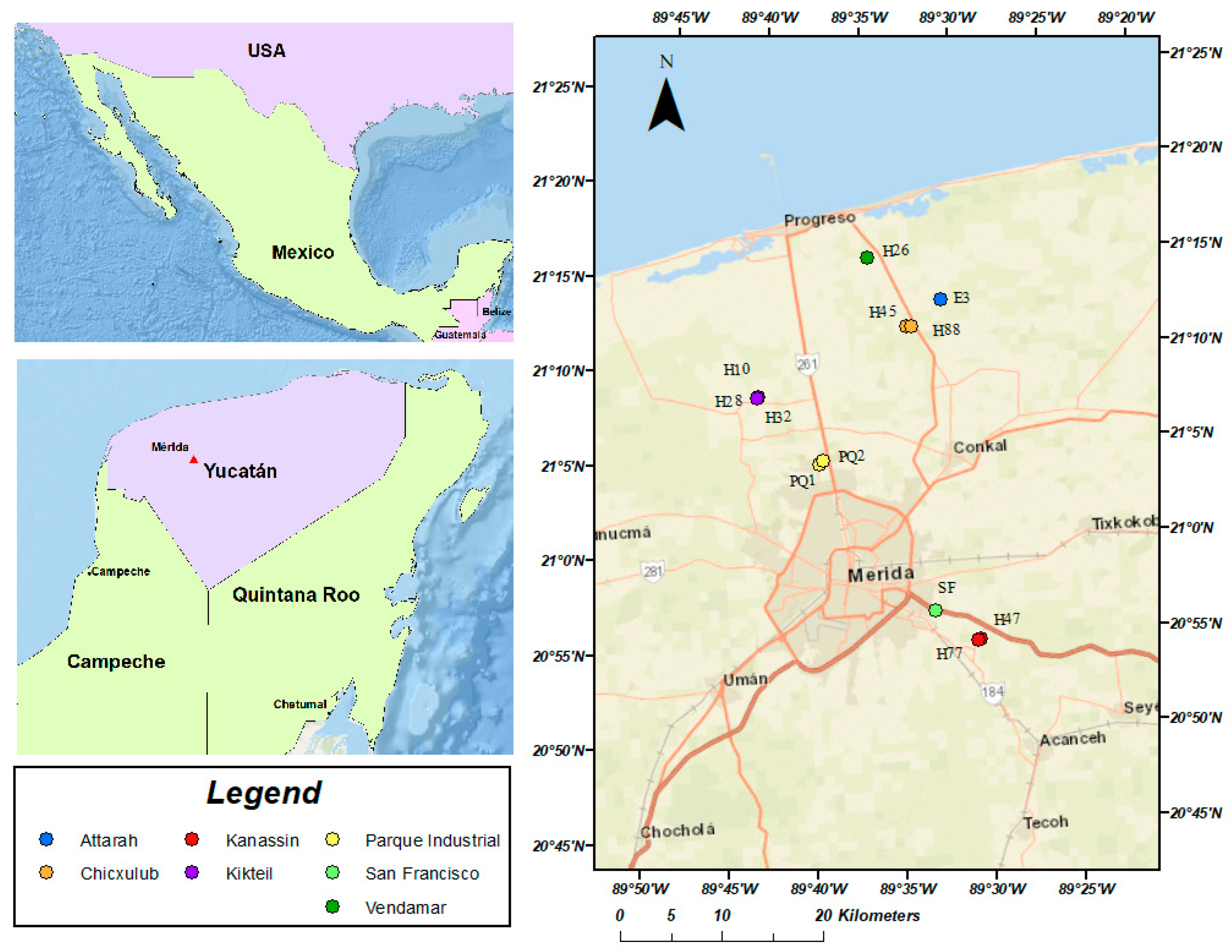
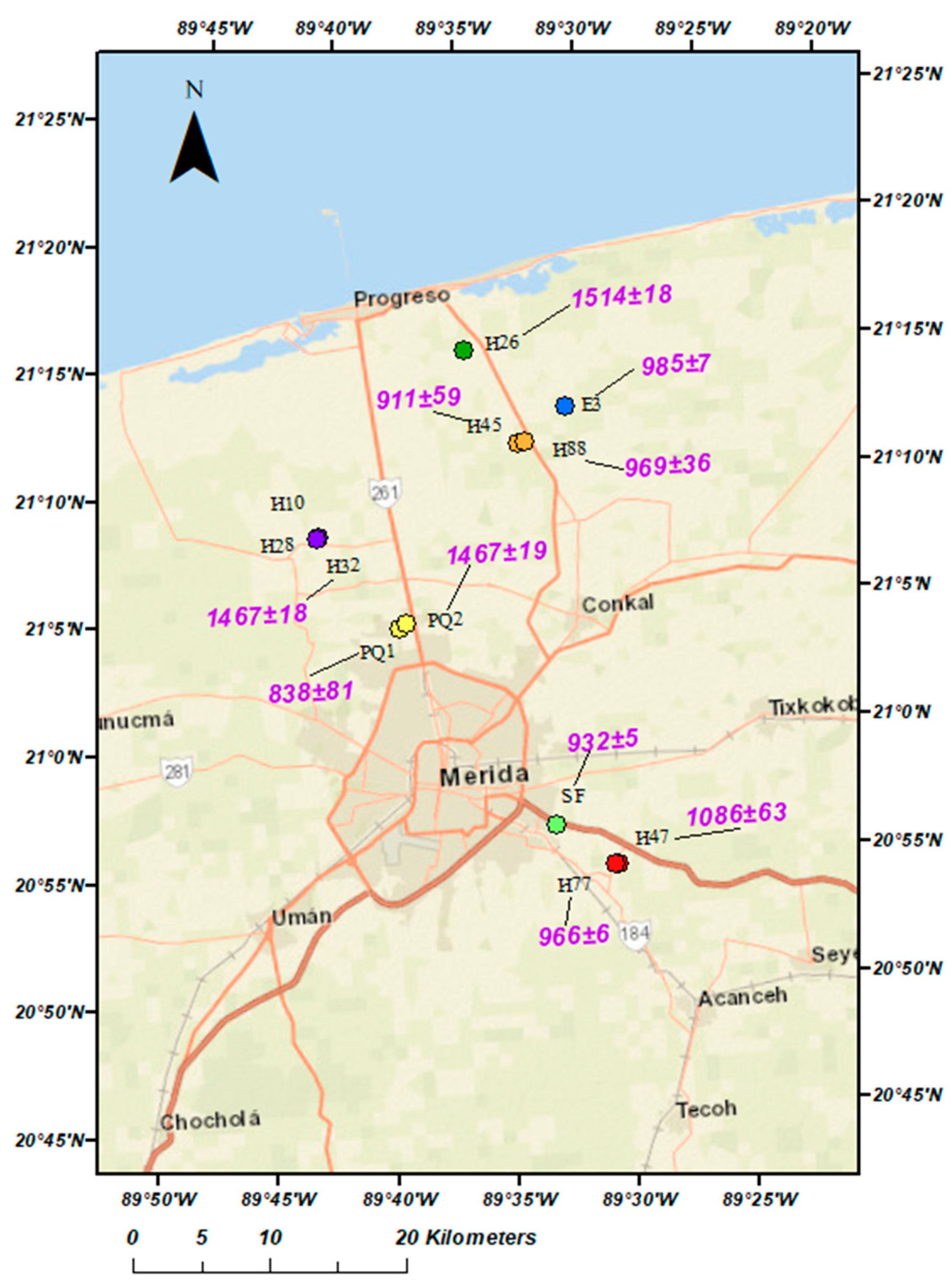
The results not only refine the chronology of limekiln usage but also provide new insights into the technological and cultural evolution of the Maya civilization. By addressing the apparent five-century gap and the subsequent transformation of lime production techniques, this study offers a framework for understanding the broader patterns of resource management, socioeconomic adaptation, and technological innovation in the Maya Region. These findings have far-reaching implications for archaeologists and scientists seeking to advance the application of archaeomagnetic methods in archaeological research worldwide. The present study analyzes the limekilns around the city of Mérida, (Yucatán) located in Xcanatun, Kikteil, the surroundings of Mérida, Chicxulub, and Kanasín (municipalities of Yucatán) (
Figure 1). The main interest of carrying out archaeomagnetic dating is to trace the temporal evolution of lime production during the pre-Hispanic period linked to the population migrations and technological transformations.
2. Chronological Framework and Sampling Details
Immersed in the tropical forest, the pre-Hispanic Mayan society developed advanced pyrotechnology, constructing kilns and establishing a lime production industry that likely began during the Late Preclassic period [
10]. The Northern Lowlands, the focus of our study (
Figure 1), is located in the northern part of the state of Yucatán, within the region known as Northern Ichkaantijoo. This area has evidence of continuous occupation from the Middle Preclassic period (1000 BC) [
11] to the colonial era. Chronology in the region is primarily based on ceramic typologies supplemented by limited radiocarbon dates. It is generally agreed that the area, with Dzibilchaltún as the primary site, reached its peak during the Late–Terminal Classic period (450–1050 AD) [
3]. Lime production surveys in the Maya Region are extensive and encompass a wide range of topics, including the production process, the composition and degradation of plasters, the origins and technological styles of lime production, the presence of limekilns, and the environmental impact of these activities [
9,
12,
13,
14,
15,
16,
17,
18,
19,
20].
More specific investigations have focused on the analysis of lime mixtures. For instance, Thibodeau [
19] analyzed samples from Xultun and San Bartolo in Guatemala, identifying calcination temperatures of approximately 800 °C achieved by artisans. Ortiz Ruiz [
9] archaeometrically characterized limekilns in the western Mayan Lowlands, while Seligson [
17] examined the economic and ecological implications of lime production through the study of limekilns at the Kiuic site in the Puuc region. Earlier studies, such as Hansen [
14], explored technological styles in stucco production, differentiating between lime and
sascab mixtures. Schreiner [
16] investigated traditional lime production technology using experimental, archaeological, and ethnohistorical approaches in the Mayan area.
Previous research emphasizes that lime production in the Maya Region was based on regional industries. Socioeconomic and environmental factors—such as technological variations, production organization, material requirements, the natural environment, settlement patterns, and local economies—shaped this industry. The use of kilns reflects a large-scale regional network rather than a singular lime industry [
10]. The distinction between lime production industries [
10] and technological styles [
14] suggests that pyrotechnological development in the Mayan area was a specialized activity supported by a network of apprentices and masters throughout the region. However, while the evidence of lime use is well documented, its dating remains insufficient to definitively establish the origins of this pyrotechnological development. In summary, it can be argued that the Mayan area represents the origin of lime production technology in Mesoamerica [
12].
The earliest reports of limekilns in the Maya Region come from the archaeological site of Cauinal, where [
21] identified two limekilns associated with small residential platforms in the site’s residential area. Abrams and Freter [
22] documented a kiln at Copán (Site 7O, Mound 32), noting that sediments and materials within the structure indicated the calcination of limestone and wood. Their architectural description suggests that the kiln was a closed structure. At Sayil, Dunning [
23] excavated an annular structure containing ash, burnt limestone, and
sascab (a Yucatec Maya term referring to construction material). Although the features resemble what is now recognized as limekilns, Dunning [
24] proposed that the structure was used for producing fertilizers to enrich cultivable soils in the Puuc region. In Cozumel, Freidel and Sabloff [
25] reported a kiln likely used for lime production at the Aguada site, while Ettinger (1983, cited in [
26]), documented another kiln at Pulltrouser Swamp.
More recently, Sierra Sosa and Martínez Lizárraga [
27] reported six limekilns in the southern area of Yucatán. In southern Campeche, Šprajc et al. [
28] documented limekilns with diameters of 3 to 4 m, showing evidence of calcination within their structures. In the Ichkaantijoo region, Ortiz Ruiz [
3] identified four distinct types of kilns used for lime production. Among these, 2 kilns contained ceramic materials dated to the Middle–Late Preclassic period out of the 68 excavated so far. Archaeomagnetic analysis [
7] further refined the chronology of lime production in the northern Mayan Lowlands, placing the use of this technology during the Late Classic period (ca. 600 AD).
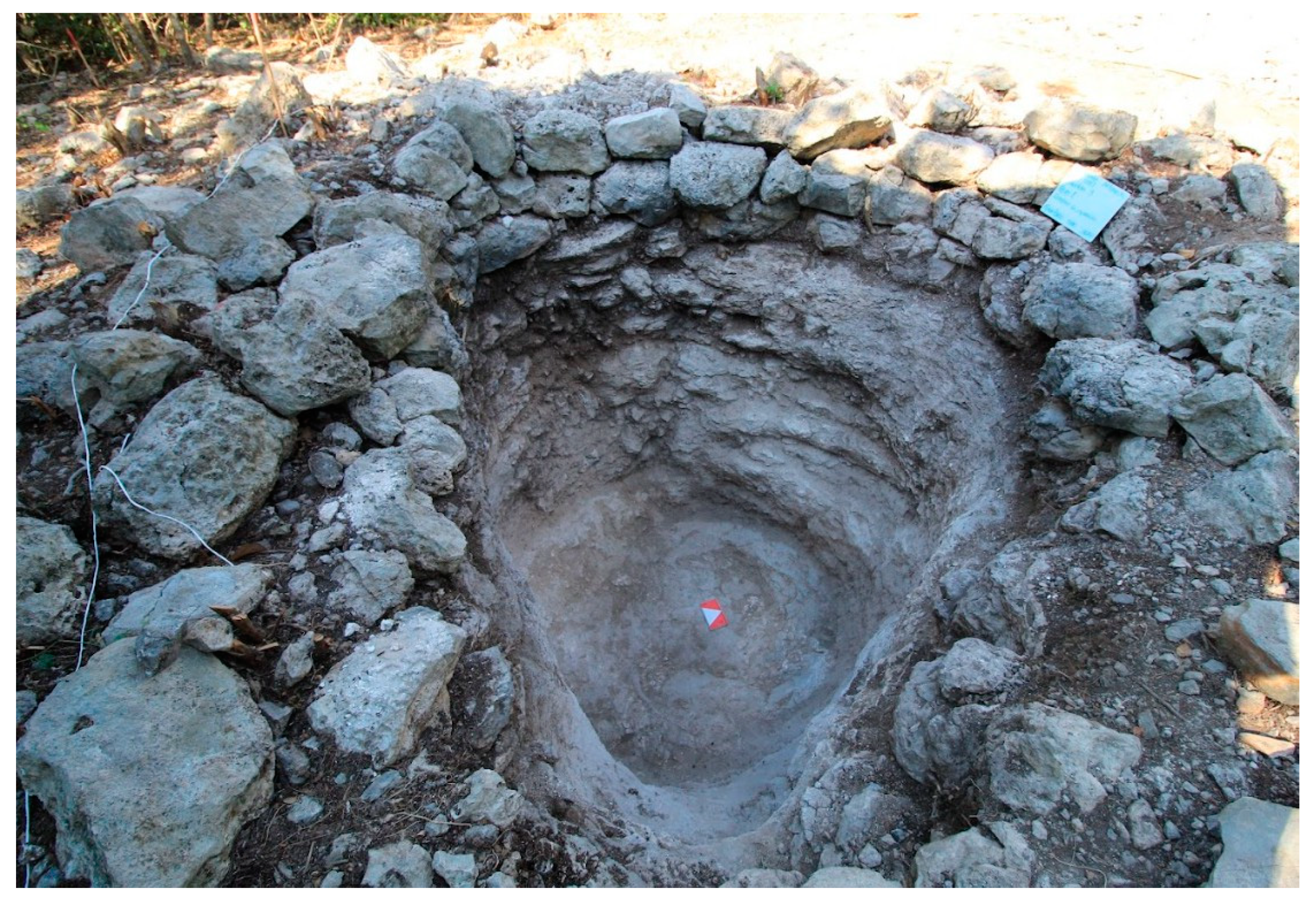
In this study, the following limekilns were sampled in detail, with a typical example of such combustion structures illustrated in
Figure 2.
2.1. Limekiln Parque Industrial 1
This shallow, circular kiln (2.50 m in diameter and 20 cm deep) was sampled during the 2020 fieldwork campaign. Associated with a domestic area, it is located to the north of the complex, likely to separate the productive area from the main structures. Calcination evidence was observed in the bedrock and collapsed stones inside the kiln, with sediment showing color changes from dark brown to grayish [
29].
2.2. Limekiln Parque Industrial 2 (Structure 83)
This circular kiln (2.4 m in diameter and 1.53 m deep) was sampled in 2021. Located in the western part of a domestic area, it is associated with a platform featuring stucco floors. Burned sedimentary rocks (dark brown to grayish) and small fragments of white concretions, possibly lime, were found inside [
29].
2.3. Limekiln Chicxulub 45
This annular structure (5 m in external diameter and 1.75 m deep) was sampled in 2021. It has an irregular depth with a cavity in the bedrock (1 m deep). The greater quantity of dark and light brown sediment mixed with calcium carbonates suggests clay-rich material linked to ceramic rather than lime production. Located southeast of a domestic complex and within the arrangement of mounds, foundations, and small platforms, it was possibly part of a production area or workshop [
30].
2.4. Limekiln Chicxulub 88a
This foundation-type limekiln measures 3.90 m by 3.10 m externally and 2.92 m by 2.23 m internally, with a depth of 0.65 m. Associated with two hydraulic structures (water wells), it features a horseshoe-shaped plan and a fire-ignition channel. The channel’s interior showed traces of fire exposure, suggesting its role in kiln operation [
30].
2.5. Limekiln Attarah 3
This ring-shaped structure (7.30 m external diameter, 3.30 m internal diameter, and 2.65 m deep) was sampled in 2020. An internal wall of stones exhibited fire exposure, and stone slabs found inside may have been used as a bonfire base due to their central placement [
31].
2.6. Limekiln Vendamar 26
Located on a rocky hill, this ring-shaped kiln (5 m external diameter, 2 m internal diameter, and 0.78 m deep) was delimited by coarse stone walls. Excavation revealed abundant charcoal in the form of branches on the bedrock, with a nearby stone table used for material preparation [
32].
2.7. Limekiln Kikteil 28
This simple structure lacks a platform and features a combustion chamber enclosed by a rough stone wall (0.50–0.70 m high) with a 1.70 m diameter. Excavations revealed organic sediment and traces of calcination on the bedrock floor, including cracks and color changes [
33]. Three layers were identified in the excavation. Layers I and II were formed by dark reddish-brown sediments with dark to black stains.
2.8. Limekiln Kikteil 32
This ring-shaped kiln shows extensive damage from stone removal. The underground combustion chamber (1.20 m diameter and 0.95 m deep) was built partly with bedrock walls and vertically arranged stones. The walls were completely calcined and cracked, with few lime concretions observed [
33].
2.9. Limekiln Kikteil 10
Initially classified as a hydraulic structure, this kiln (1.70 m in diameter and 2.78 m deep) was later reclassified as a furnace during excavation. Semi-oval in shape, it contained ash, lime concretions, calcined stones, dark brown sediments, and a few pottery fragments [
33].
The variety of structural designs, evidence of calcination, and association with domestic and productive areas underline the significance of these kilns in the socioeconomic landscape of the Maya civilization and provide crucial insights into the technological and spatial organization of lime production in the Maya Region.
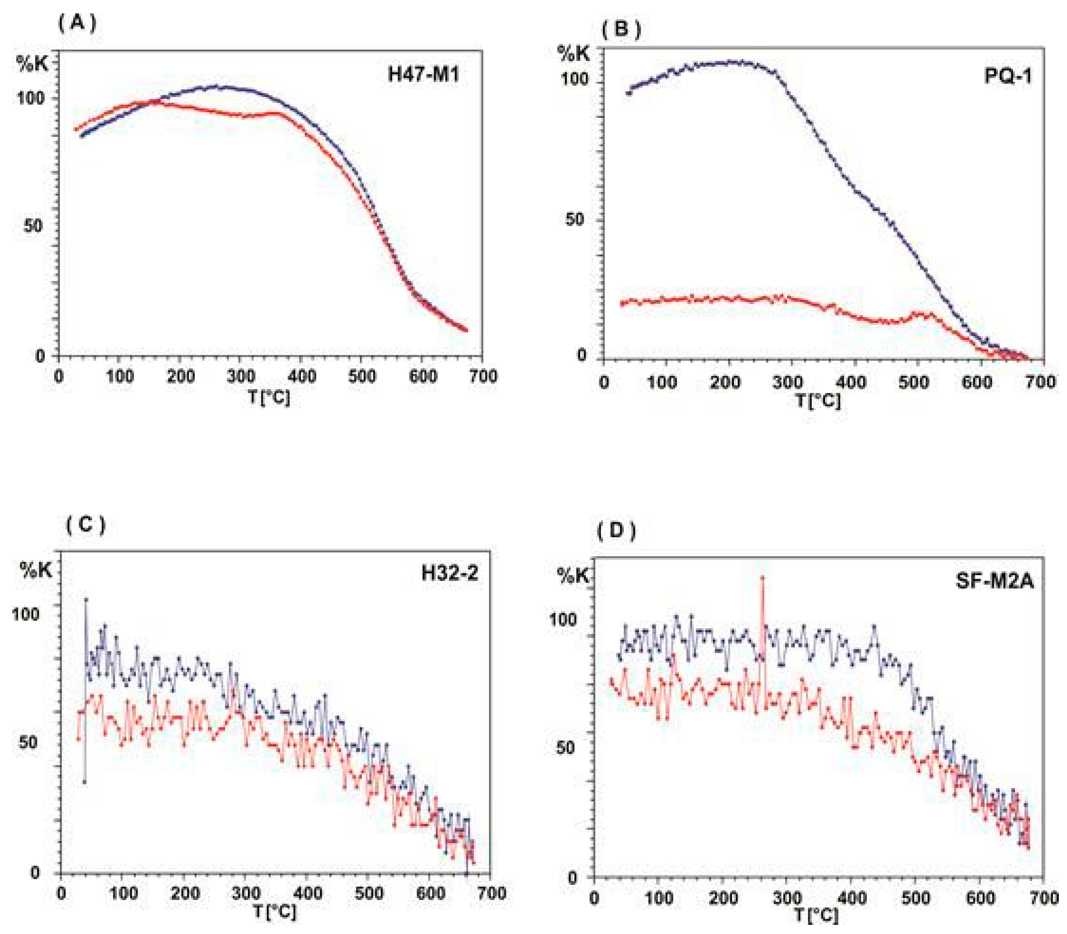
3. Susceptibility vs. Temperature Continuous Measurements
Magnetic susceptibility as a function of temperature (continuous thermomagnetic curves) was measured using the AGICO MFK-1 instrument, with Curie temperatures estimated following the method described by Prevót et al. [
34]. A total of 24 curves were analyzed, revealing 3 distinct types of magnetic mineralogical behavior (
Figure 3):
Type A: In 20% of the samples, a low-temperature phase is observed around 260 °C, speculatively attributable to goethite. Subsequently, the primary magnetic phase becomes evident, reaching a Curie temperature near 580 °C, at which point more than 90% of the initial magnetic susceptibility disappears. This behavior suggests the presence of nearly pure magnetite or titanomagnetite with a very low titanium content as the dominant magnetic carrier.
Type B: This type, observed in 60% of the specimens, exhibits a single magnetic phase during heating, with a Curie temperature consistent with magnetite. However, during cooling, a significant increase in susceptibility is noted, exceeding 400% of the initial value. Two magnetic phases emerge: one consistent with nearly pure magnetite and a second phase around 340 °C. This behavior is highly irreversible and magnetically unstable.
Type C: In the remaining 20% of the specimens, the magnetic signal is very weak. While the presence of magnetic minerals (likely magnetite or titanium-poor titanomagnetite) could be confirmed, full identification was challenging due to the signal being near the instrument’s sensitivity limit. In a few cases, cooling reveals a notable increase in magnetic susceptibility, exceeding 100% in some specimens. This behavior suggests possible magneto-chemical transformations of the minerals during heating.
4. Alternating Field Demagnetization
Archaeomagnetic methodology is now rather standardized and is fully described in many previous papers [
35,
36,
37], while a comprehensive review may be found in Carrancho et al. [
38].
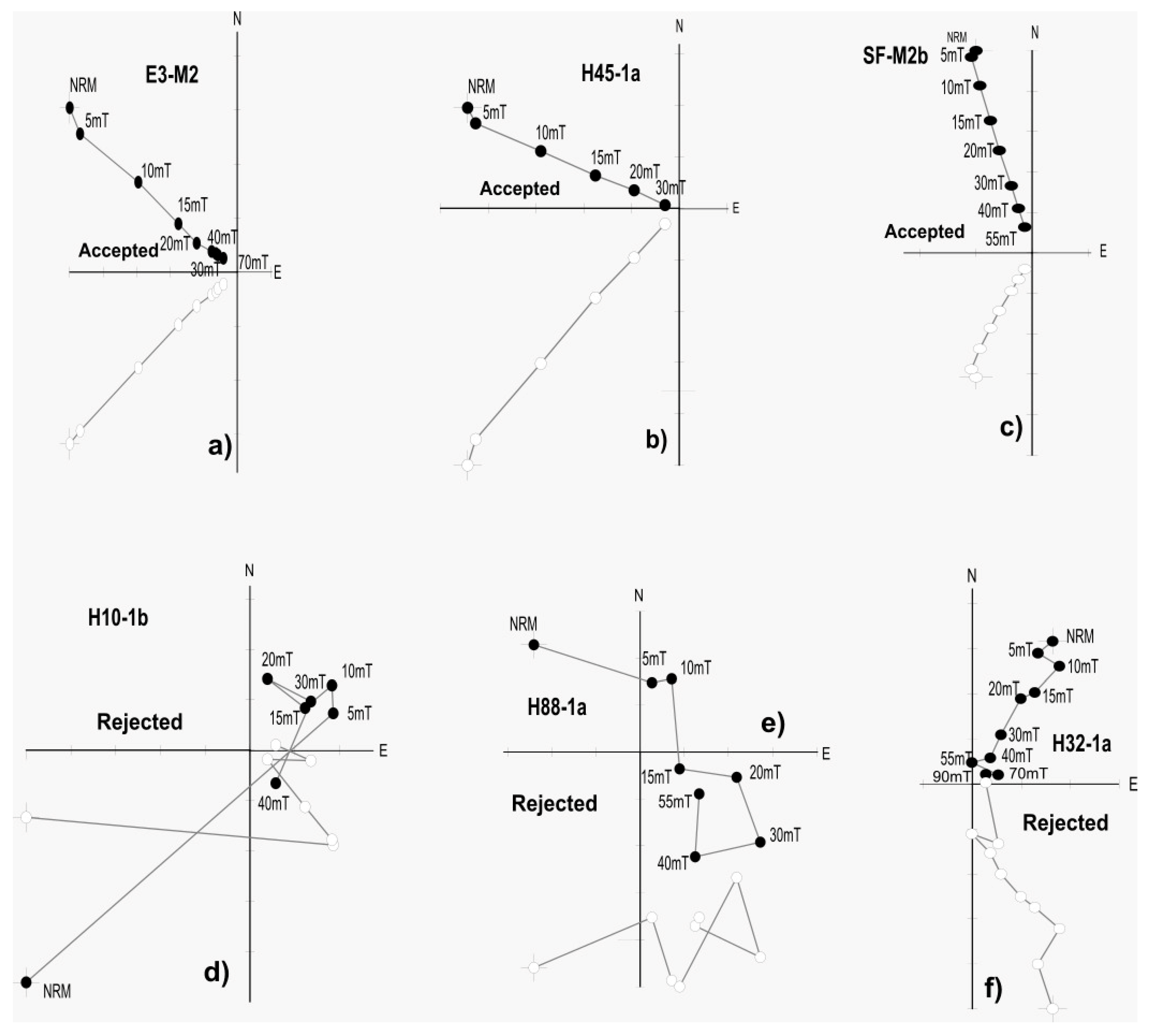
Progressive step-wise alternating field (AF) demagnetization was employed to extract primary characteristic magnetization components using an AGICO LDA-3 demagnetizer with a maximum peak alternating field of 100 mT. The results of these AF demagnetizations, summarized below and illustrated in
Figure 4, highlight varying behaviors across different sites:
Attarah E3: Sixteen specimens were demagnetized. An initial, minor viscous component was removed by applying fields of 5 mT. Subsequently, a linear unidirectional behavior toward the origin was observed, achieving demagnetization of over 80% of the total magnetization at 70 mT. Mean destructive fields (MDFs) ranged from 15 to 20 mT. Characteristic directional components (ChRMs) were calculated using 5–7 points via principal component analysis (PCA, see [
39]), with the maximum angular deviation (MAD) values between 0.8° and 4.8°. Three specimens with inconsistent directions were excluded, resulting in a mean direction of Dec = 348.6°, Inc = 25.6°, α
95 = 3.8° (n = 13 specimens).
Kikteil H10: All eight specimens exhibited chaotic, unstable behavior from the early stages, preventing the isolation of primary directional components.
Kikteil H28: Sixteen specimens cut from two hand samples displayed instability during early demagnetization stages, with over 50% of the magnetization lost at 5–15 mT. No linear trend to the origin was observed in the AF fields up to 70 mT, and directional components could not be determined.
Kanassin H47: From 24 specimens, a minor viscous component was eliminated at 5 mT. A linear univectorial behavior was achieved, with 90% demagnetization at 55–70 mT. The MDF values ranged from 15 to 30 mT. Characteristic directions were determined using at least eight steps (MAD: 0.4°–1.4°). Three specimens with deviated directions were excluded, yielding a mean direction of Dec = 352.6°, In. = 39.9°, α95 = 4.0° (n = 21 specimens).
Kanassin H77: From 24 specimens, a significant initial viscous component was removed at 5–15 mT. Linear behavior was achieved with 80% demagnetization at 50–60 mT. The MDF values ranged from 15 to 30 mT. Six to eight points (MAD: 0.7°–4.1°) were used for PCA analysis. Three specimens with inconsistent directions were excluded, yielding a mean archaeodirection of Dec = 345.2°, Inc = 19.5°, α95 = 4.2° (n = 21 specimens).
Chicxulub H88: In total, 16 specimens were demagnetized. Eight specimens from one hand sample exhibited chaotic behavior, while those from a second monolith sample showed stable linear trends after eliminating minor viscous components. The MDF was approximately 15 mT, and characteristic directions were calculated using at least four points (MAD: 0.3°–1.6°). The mean direction is Dec = 354.5°, Inc = 31.0°, α95 = 8.0° (n = 7 specimens).
Vendamar H26: Sixteen specimens from two hand samples exhibited multicomponent behavior after removing viscous components, with linear trends toward the origin of the diagram emerging above 30 mT. Demagnetization exceeded 90%, and MDF values ranged from 10 to 40 mT. Six specimens with abnormal directions were excluded, yielding mean archaeomagnetic directions of Dec = 350.9°, Inc = 50.6°, α95 = 8.1° (n = 10 specimens).
Kikteil H32: Of 16 specimens from 2 hand samples, most displayed linear univectorial behavior after removing minor viscous components at 5–10 mT. The MDF values ranged from 15 to 30 mT for nine specimens, while the other five specimens required fields of 55–90 mT. Specimens with MAD > 10° or insufficient data points (<4) were excluded. The mean direction is Dec = 356.0°, Inc = 39.4°, α95 = 6.5° (n = 9 specimens).
Chicxulub H45: From 16 specimens, 7 showed linear behavior with viscous components removed at 10 mT, and 90% of magnetization was removed when the demagnetization field reached 30 mT, with the MDF values between 15 and 20 mT (MAD: 0.4°–4.8°). Mean directions are Dec = 332.8°, Inc = 43.7°, α95 = 9.0° (n = 9 specimens).
PQ1: Eight specimens from a large monolith of the burnt floor showed univectorial behavior after removing viscous components at the fields of 3–10 mT. The MDF values were around 10 mT, with 80% demagnetization at 15 mT. A single specimen with an MAD value of 10° was excluded, yielding a mean direction of Dec = 340.8°, Inc = 51.6°, α95 = 6.5° (n = 7 specimens).
PQ2: Eight specimens exhibited significant initial viscous components (30–40% of total magnetization) removed at 5–10 mT. A unidirectional component was observed with 90% demagnetization between 15 and 20 mT (MDF: 8–10 mT, MAD: 2.7°–5.8°). Two specimens were excluded, resulting in a mean direction of Dec = 354.9°, Inc = 39.2°, α95 = 6.9° (n = 5 specimens).
San Francisco: From 24 specimens from the kiln, a minor viscous component was eliminated at 5–10 mT. A univectorial trend was achieved using at least four data points, with 80% demagnetization at 55–70 mT (MDF: 15–30 mT and MAD: 0.9–6.7°). Three specimens were excluded due to incoherent clustering, yielding mean directions of Dec = 350.7°, Inc = 18.5°, α95 = 3.3° (n = 20 specimens).
These results highlight the variability in magnetic stability and directional coherence across the studied kilns, reflecting differences in material properties and preservation conditions. The identified mean directions provide a satisfactory amount of archaeomagnetic data for refining the chronology of lime production in the Maya Region.
5. Discussion
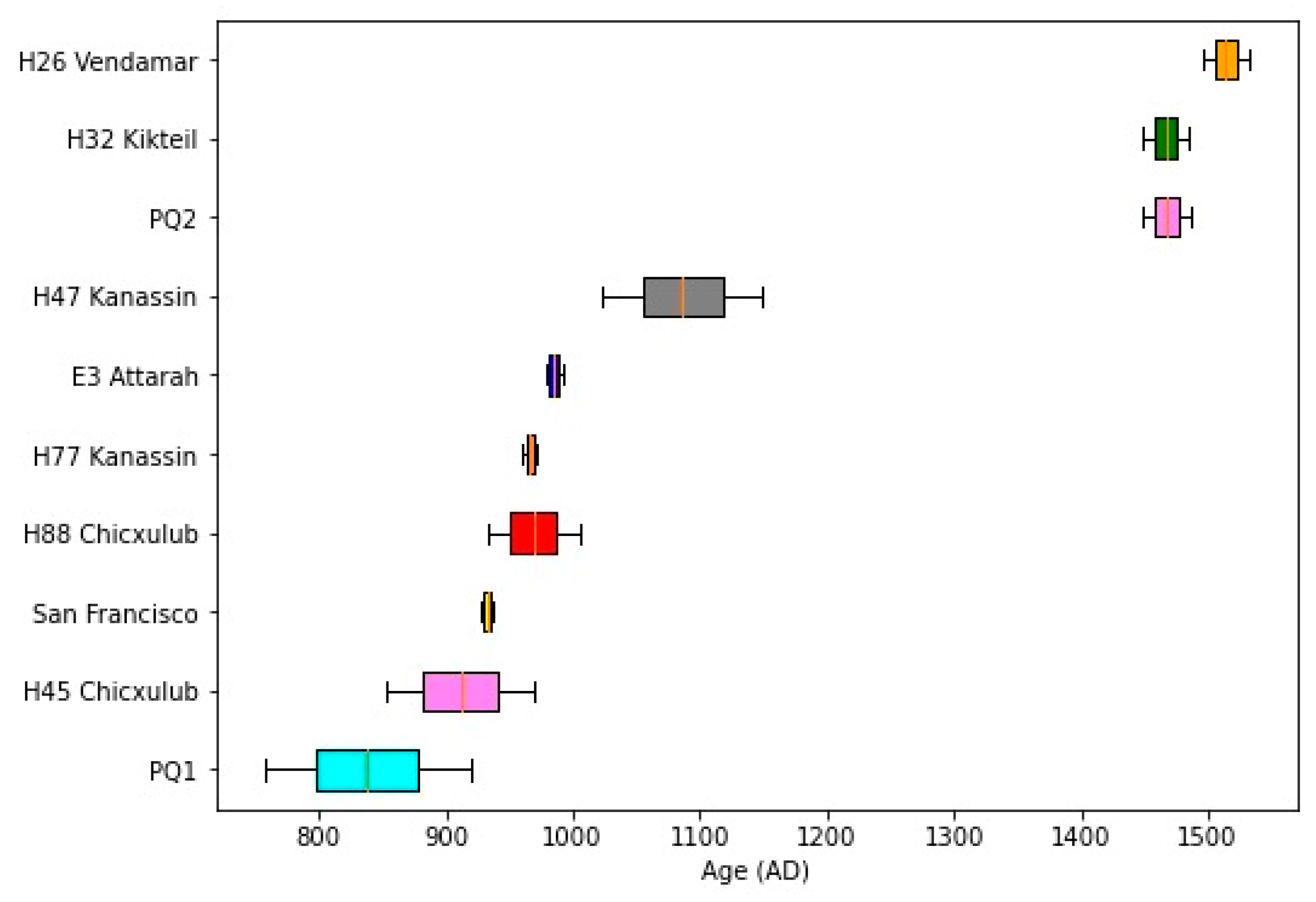
This study successfully obtained mean archaeomagnetic directions for ten out of twelve kilns/sites, supported by at least five individual determinations per site, with α
95 confidence angles ranging from 3.3° to 9.0°. No reliable data could be determined for Kikteil H10 and H28 due to unstable behavior during the magnetic treatments. A summary of the mean directions and their associated precision parameters is provided in
Table 1 and illustrated in
Figure 5.
Archaeomagnetic age intervals were estimated using both global geomagnetic models and available local reference paleosecular variation (PSV) curves (
Table 2,
Figure 6). The models applied included the SHA.DIF.14K model by Pavón-Carrasco et al. [
41], covering the last 14,000 years, and the SHAWQ.2K model by Campuzano et al. [
42], which spans the last 2000 years. Additionally, the local PSV curves of Mahgoub et al. [
43] and García-Ruiz et al. [
44] were incorporated. Due to unstable thermomagnetic behavior observed in the specimens, absolute intensity experiments were not performed; consequently, dating relied solely on magnetic declination and inclination. Archaeomagnetic intervals predating 600 AD were deemed archaeologically improbable and excluded from the analysis.
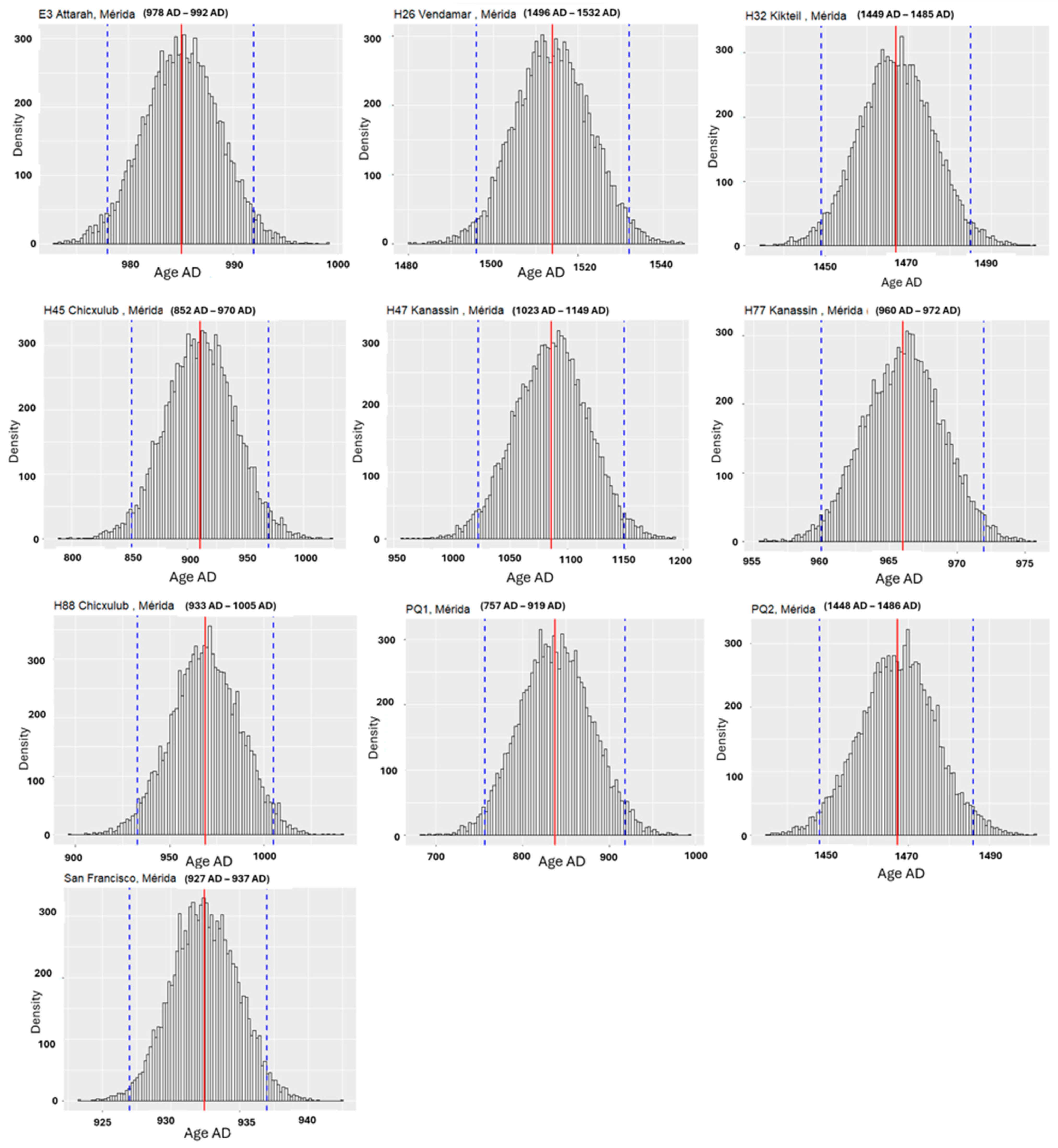
Archaeomagnetic dating was conducted using the MATLAB-based tool ‘
archaeo_dating’ developed by Pavón-Carrasco et al. [
45]. The results are summarized in
Table 2 and visualized in
Figure 6. To refine the dating further, the Bootstrap resampling method [
46] was employed to determine the optimal age ranges with statistical confidence for each kiln (
Table 3,
Figure 7). It should be emphasized that this procedure does not replace the archaeomagnetic dating, but rather, estimates the most probable statistical (Bootstrap) age. Similar methodologies have been successfully applied in previous studies (e.g., [
47]). The most probable ages at 95% confidence intervals and their uncertainties were calculated from the resulting probability distributions (
Table 3,
Figure 8 and
Figure 9).
The diversity of constructive techniques and the pyrotechnological use of kilns in the Mayan area highlight the extensive construction industries that once flourished in the region. Seligson et al. [
10] suggested the existence of at least two distinct lime production industries, differentiated by the distribution and types of kilns used to burn limestone. However, the precise temporality of the kiln usage remained unclear, with most kilns tentatively dated to the Late–Terminal Classic period. Goguitchaichvili et al. [
4] re-evaluated the available archaeomagnetic data, refining the temporal framework and identifying two distinct patterns of kiln construction and usage. For earlier periods, kilns were typically built within foundations that supported rooms, while in later periods, limekilns were constructed in isolated locations, both developments dating to the Postclassic period.
Ortiz Ruiz et al. [
7,
8] reported new archaeomagnetic dates from the Northern Plains, suggesting the reuse of kilns throughout the late periods. Some dates corresponded to the historical period, potentially linked to the rise of
henequen haciendas in the Yucatán. The data revealed a late cluster of kiln use in the Chicxulub area, likely associated with the development of Spanish enclaves during the conquest, the formation of Indian villages, and the establishment of haciendas.
The new archaeomagnetic data from this study provide valuable insights into the relationships between lime production industries and the economic and political shifts in the region. The presence of kilns dated to the Postclassic period has now been documented not only in the Chicxulub area but also in the Kikteil region to the west and near the Xiol archaeological site to the south. Notably, one late limekiln is linked to the historic coastal town located between the defensive walls of Chuburná and Chicxulub, commonly referred to as “the trenches”. These defensive structures, built during the colonial period as part of Mérida’s military architecture, are dated to 1722, as recorded in a plan from Governor Don Antonio de Cortaire’s visit [
48].
A key finding of this study is the identification of two clearly defined clusters of archaeomagnetic age intervals. As illustrated in
Figure 8 and
Figure 9, the age distribution is concentrated around 900–1000 AD and approximately 1500 AD, just before the Spanish conquest, representing a pre-Hispanic/colonial contact period (poorly defined ages from limekilns PQ1 and H47, due to their large α
95 confidence angles, were excluded from this analysis). Two possible interpretations arise from this bimodal distribution. First, the age intervals may indicate continuous lime production over at least six centuries. Alternatively, some limekilns may have been reused after a hiatus of nearly 500 years. The reasons for this substantial gap in activity remain unknown but warrant further investigation to understand the socioeconomic and environmental factors contributing to this phenomenon.
The results reveal a dynamic interplay between technological practices and socioeconomic transitions. For earlier periods, kilns were integrated into architectural foundations, while in later periods, they were constructed in isolated locations, reflecting shifts in production strategies. The data also suggest that limekilns were reused during the colonial era, possibly to support the rise of henequen haciendas and the formation of Spanish enclaves. These findings demonstrate the potential of archaeomagnetic methods to illuminate patterns of resource management and socioeconomic adaptation over centuries.
6. Conclusions
This study provides archaeomagnetic age estimates for pre-Hispanic and colonial-era limekilns in the Maya Region, significantly refining the chronological framework for lime production. By identifying two distinct clusters of age intervals—900–1000 AD and approximately 1500 AD—the research highlights the continuity and potential reuse of lime production technologies over six centuries, separated by a hiatus of nearly 500 years. The findings link the lime production to key socioeconomic and political transitions in the Maya Region, including the integration of pre-Hispanic technologies into Spanish colonial practices. The spatial distribution of the kilns, extending beyond the Chicxulub area to Kikteil and Xiol, further emphasizes the regional scale of lime production and its role in shaping settlement patterns and infrastructure.
The study demonstrates far-reaching applicability by advancing the use of archaeomagnetic dating in reconstructing the chronology of pyrotechnological features. By integrating global geomagnetic models, local PSV curves, and innovative statistical techniques, this research contributes to broader discussions on the technological evolution and cultural resilience of ancient societies. Future investigations exploring complementary dating techniques and social and environmental factors could further enrich our understanding of this critical aspect of Maya civilization.
In summary, the absolute chronology associated with the lime production in the Mayan area evidenced at least two periods of use during the Mesoamerican Late Classic and the late Postclassic. The early use of kilns remains a challenge for Mayan archaeology because the reliable reports of the use of limekilns or pyres in lime production are scarce, given their ephemeral nature. Archaeomagnetic techniques date the last use of kilns, which may indicate that they were reused during the early colonial period in accordance with the population changes and migration patterns detected at the end of the Postclassic period and the beginning of the colonial era. The new chronological dates reported in this study allow us to reconstruct the lime production industries in the north of the Mayan area and to trace the socioeconomic context. More recently, Ortiz Ruiz et al. [
7,
8] successfully dated different moments of use of a limekiln and reconstruct its history through the archaeomagnetic method. The results obtained not only allow researchers to define the pattern of use of the kilns, but also to pyrotechnologically trace the advances that the Maya achieved in the production of lime, managing efficient calcination with less loss of raw material compared with pyres. The implications of the absolute dating offered by archaeomagnetism permit a reanalysis of the consequences of lime manufacturing and the Mayan collapse. In addition to the possibility of understanding the Mayan collapse based on multiple factors, the study of the kilns also helps to understand the dynamics that the Maya established with their environment and how they materialized the efficient and dynamic production during the late Classic, Postclassic, and early colonial periods in a changing world.


 ,
, 


