Article

Plants, Fire and Landscape at the Prehistoric Pile-Dwelling Village of Palù di Livenza (PaluON1), UNESCO Site in the Italian Alps

1
Laboratorio di Palinologia e Paleobotanica, Dipartimento Scienze Vita, Università degli Studi di Modena e Reggio Emilia, Via Campi 287, 41125 Modena, Italy
2
Cora Società Archeologica S.r.l., Via Salisburgo 16, I-38121 Trento, Italy
3
NBFC, National Biodiversity Future Center, 90133 Palermo, Italy
4
ArqueoUIB, Department of Historical Sciences and Theory of Art, Carretera de Valldemossa Km 7.5, CP07122 Palma, Spain
5
Soprintendenza Archeologia, Belle Arti e Paesaggio del Friuli Venezia Giulia, Piazza della Libertà 7, I-34135 Trieste, Italy
*
Author to whom correspondence should be addressed.
Quaternary 2023, 6(2), 34; https://doi.org/10.3390/quat6020034
Submission received: 20 April 2023 / Revised: 19 May 2023 / Accepted: 29 May 2023 / Published: 1 June 2023

Abstract

:
This paper presents palynological data obtained from a trench excavated at the Neolithic pile-dwelling archaeological site of Palù di Livenza (northeastern Italy). The site is in a wetland located in a tectonic basin at the foot of the Cansiglio plateau, crossed by the Livenza river. Environmental conditions have made this wetland a suitable area for settlements since prehistoric times. Thanks to the peaty sediments that characterise the area, archaeological materials and botanical remains have been exceptionally well preserved. Their study has shed light on a Neolithic pile-dwelling settlement that developed in various phases between c. 6350 and 5600 cal BP (c. 4400 and 3650 BC), and has also allowed for a detailed environmental reconstruction of the surrounding environment. A vertical sequence of 20 samples was analysed to study pollen, non-pollen palynomorphs and microcharcoals. An age-depth model was performed based on three radiocarbon dates. The palynological analysis provided insight into the response of vegetation to environmental changes caused by both climatic fluctuations and human pressure. In this sense, it was possible to highlight differences in vegetation cover, some fires, the use of woody resources, the spread of cereal fields, as well as the presence of other cultivated plants and plant processing by the people within the village.

1. Introduction

Information on prehistoric settlements that developed in the wetlands between the high plain and the foothills extending into northeastern Italy is currently scarce. One of the places that has provided the richest and most intriguing evidence of wetland sites is Palù di Livenza. This includes a well-preserved pile-dwelling site that is very interesting for understanding life during the Neolithic period. Its location in the Pordenone foothills is significant due to its geographical proximity to Austria and Slovenia, where important pile-dwelling settlements of prehistoric times are known. Thanks to the numerous archaeological discoveries, Palù di Livenza was inscribed by the UNESCO World Heritage in 2011, more specifically within the transnational series of Prehistoric pile-dwelling sites in the Alps (code site IT-FV-01). In this site, the high environmental value and the hydrogeological peculiarities are closely intertwined with the archaeological heritage that testifies to the life of the first European agricultural communities.
Following registration to the UNESCO list, a plan of knowledge, protection and enhancement of the pile-dwelling site was launched under the coordination of the ‘Soprintendenza Archeologia, Belle Arti e Paesaggio’ of Friuli Venezia Giulia, the region where the site is located. The richness of the archaeological deposit has revealed the presence of various overlapping Neolithic settlements on stilts that followed each other between the last centuries of the seventh and the middle of the sixth millennium BP (c. 4400 and 3650 BC). Different investigations have also confirmed the excellent state of the preservation of the organic remains, such as plant macroremains (wood, seeds and fruits). This is of fundamental importance for the understanding of agricultural practices and methods of exploiting plant resources in the life period of the pile-dwelling villages in the wetlands [1,2]. Such environmental contexts are known to be important archives that record environmental transformations over time (e.g., [3,4,5,6]). Apart from the climatic oscillations, these changes are often strongly influenced by human presence or impact on the surrounding environment, giving a unique insight into the human-environment relationship and the adaptive strategies pursued by communities to live in this peculiar environment [7,8,9,10,11,12].
By combining the archaeological and naturalistic interest of the area, the site of Palù di Livenza turned out to be a privileged place to carry out a palynological study aimed at environmental reconstruction, due to both the multidisciplinary approach and the exceptional preservation of the context. We present the detailed study of the on-site trench PaluON1, aiming to reconstruct the local flora and vegetation of the past and the changes undergone in Palù di Livenza, and to discriminate human influence in these changes [13,14]. This study integrates previous palaeoecological analyses obtained from a pollen core in the proximity of Sector 2 [15] and the palaeoeconomic and dietary information inferred from the archaeobotanical studies carried out on plant macroremains during the first site surveys [16,17,18].

2. General Settings

In northeastern Italy, the name Palù does not designate a swamp in the classical sense of the term (from the Italian word “palude”, i.e., an area of land permanently saturated, or filled, with water), but indicates a humid agricultural landscape with a strong natural connotation. Palù means a place resulting from a long interaction between communities and the environment. The ecological feature of this type of environment is the great variety of interlinked habitats in limited spaces, where the marshy areas have been transformed into hay meadows with reclamation interventions since the High Middle Ages. Palù was the basis of a traditional agricultural economy based on the exploitation of different natural resources from three different environments in which water was the main component: swamp, stable meadows and humid forest [19,20]. In particular, the occupation and exploitation of the Palù di Livenza wetland began at the end of the Neolithic period, but unlike other places with similar environmental features, it was no longer permanently frequented until historical times.

2.1. Geographical and Environmental Settings

Palù di Livenza (Figure 1) is a wetland area located in a basin at the foot of the Cansiglio plateau in the Pordenone area extending into the Caneva and Polcenigo territory, crossed by the Livenza and Livenzetta rivers. The wetland extends into a wide tectonic depression at ca. 30 m a.s.l., where the karst springs Molinetto, Santissima and Gorgazzo flow and feed the Livenza groundwater-fed river. The Palù basin covers an area of ca. 100 hectares with a NE-SW orientation [21,22].
Currently, the area between the municipality of Polcenigo and Caneva is characterised by swamps and peat bogs, which have formed in the basin since the beginning of the Holocene when climatic conditions locally led to the disappearance of the former lake. This lake was formed between c. 15,000 and 11,000 years ago (Lateglacial), when alluvial deposits from the Puster, Mena and Cellina rivers blocked the natural flow of the Livenza across the plain, causing the formation of a lake in the basin [21,22,23]. At the beginning of the Holocene, the establishment of more temperate climatic conditions led to the gradual drying up of the lake and the transformation of the basin into a peat with rivers and ponds [24]. Currently, Palù di Livenza has a continental climate, with cold to very cold winters and hot summers.
According to the Vegetation Chart of Italy [25], Palù di Livenza belongs to three main plant associations: Buglossoido-Ostryo carpinifoliae sigmentum (vegetation series) intertwined with Mercuriali ovatae-Ostryo carpinifoliae sigmentum and Ostryo carpinifoliae-Fraxino orni sigmentum. The Buglossoido-Ostryo carpinifoliae sigmentum (which corresponds to the Orno-Ostryetum in the Pre-Alps) hosts species such as Quercus pubescens Willd. and Q. petraea (Matt.) Liebl., Acer campestre L. and A. opulus Mill., Corylus avellana L., Fraxinus ornus L., Tilia cordata Mill., Viburnum lantana L., Colutea arborescens L., Cornus mas L., Juniperus communis L., Prunus malaheb L., Carex digitata L., Festuca heterophylla Lam., Fragaria vesca L. and Viola hirta L. In the Ostryo carpinifolie-Fraxino orni sigmentum, the most common arboreal species are Ostrya carpinifolia Scop. and Fraxinus ornus, with Coronilla emerus L., Colutea arborescens, Ligustrum vulgare L., Cornus mas and C. sanguinea L. as shrubs; between the herbs, there are Campanula bononiensis L., Melittis melissophyllum L., Hepatica nobilis Shreb., Carex digitata and C. humilis Leyss. [25].

2.2. Archaeological Context

Findings of wooden poles and archaeological materials at Palù di Livenza have been known since the 19th century. However, it was only in the mid-1960s that the importance of the site was confirmed by several prehistoric artefacts that were found during the excavation of a drainage channel in the northern part of the basin [26,27,28]. Several investigations have been carried out in the last forty years and have led to the discovery of many archaeological materials, which revealed the exceptionality of the prehistoric site. Systematic investigations through field surveys, excavations and coring were focused along the drainage channel in Sector 1 and Sector 2 (Figure 2). The findings revealed a Neolithic pile-dwelling settlement (Figure 2a). The archaeological excavations revealed wooden features on aerial platforms and land reclamation works, proving different phases of site occupation [29,30]. Therefore, as mentioned above, in 2011, Palù di Livenza was added to the UNESCO World Heritage List, being characterised by the excellent preservation of both archaeological materials and organic remains [31,32,33,34].
Between 2013 and 2021, a new phase of research was launched at Palù di Livenza in Sector 3 (Figure 2b). Although the excavation area was limited to 48 m2 and corresponds to an almost negligible part of the real extension of the archaeological site, the investigations outlined a diachronic sequence in five structural Neolithic phases in which four different pile-dwelling features are interposed by abandonments of the area (Figure 3). Hundreds of wooden elements were identified consisting of both horizontal beams and fixed vertical poles. The construction systems identified have similarities of a technical nature and use the same type of structure for their foundation: sleeper beams and plinths made up of semi-finished oak logs supported raised buildings, the function of which could be both that of houses and of ancillary dwellings to them, such as storehouses or granaries [35,36,37,38].
The materials suggest that the lower Neolithic structural phases 1–4 can be ascribed to the Square Mouthed Pottery culture (Cultura dei Vasi a Bocca Quadrata) in some of its various aspects evolving in the second half of the seventh millennium BP, between 6350/6250 BP (corresponding to 4400/4300 and c. 4000 cal BC). The final phase 5 is attributed to the Late Neolithic Alpine Groups, which are datable between 5900 and 5600 BP (c. 3950 and 3650 cal BC) [35,36,37,38].

3. Materials and Methods

3.1. Chronology

The age–depth model was constructed using the “Bchron” package [39] performed with R, version 4.1.0 [40]. The age-depth model relies on three radiocarbon dates corresponding to three of the stratigraphical units of the trench studied, attributed to the Neolithic period: LTL16159A (SU 7; [36]), and DSH9888_CS (SU 11) and DSH9891_CS (SU 12) that are presented for the first time here. The date of 2020 AD was also considered in the model for the modern surface layer. Calibration was carried out using Oxcal 4.4 (online version, [41]) and the IntCal 20 calibration curve [42].

3.2. Pollen Sampling

Sampling was performed in Sector 3 (12.48244° E; 46.02219° N), SW corner of Section 4, during the archaeological field works in 2016. This sector does not cover all of the archaeological phases recognised in Sector 3 at the site of Palù di Livenza. The SW sequence of Sector 3 sampled for palynological analysis represents: (i) the pre-settlement phase (SU 23), (ii) the archaeological phases from 3 to 5 (SSUU 14, 13/12, 11, 7), (iii) the final phase corresponding to the abandonment of the settlement (SSUU 6, 4, 3). For the palynological study, 20 samples were taken from the stratigraphic profile at about 5-cm intervals (Figure 4; Table 1).

3.3. Pollen Treatment and Analyses

The treatment of the palynological samples was performed according to the method in use at the Laboratory of Palynology and Palaeobotany of Modena [43]. The method includes sieving about 2 g of sediment, treatment with HCl 10% and HF 40%, acetolysis and heavy liquid flotation with sodium metatungstate hydrate. Lycopodium spore tablets were added before the treatment to calculate the concentration (expressed in p/g). Pollen grains were identified at 1000× magnification on permanent slides, with the help of atlases and keys (e.g., [44,45,46,47]), and the reference pollen collection of the laboratory. On average, 300 pollen grains per sample were counted and identified at the lowest possible taxonomic level. Percentages were calculated on a Pollen Sum including both identified and unidentified pollen grains. Sums of selected pollen taxa and sums useful for environmental and land use reconstructions were calculated: Arboreal Plants and Non-Arboreal Plants (AP/NAP ratio); mixed oakwood with Carpinus betulus, Corylus avellana, Carpinus orientalis/Ostrya carpinifolia type, deciduous Quercus, Tilia, Ulmus; hygrophilous trees: Alnus, Populus, Salix; API—Anthropogenic Pollen Indicators [48]: Artemisia, Centaurea nigra type, Cichorieae, Trifolium type, Plantago, Urtica dioica type and cereals; LPPI—Local Pastoral Pollen Indicators [49,50]: e.g., Trifolium type, Ranunculaceae, Galium type and Asteraceae (mainly Cichorieae sensu [51]).
NPPs were identified and counted in the same slides used for pollen analysis (e.g., [52,53]). Particular attention was given to algae, spores and coprophilous fungi. Their concentrations were calculated as npp/g. All data were elaborated through the Tilia software [54,55]. Pollen zones were identified based on cluster analysis and visual examination.
Pollen datasets from two off-site/natural series that include the same period and are in the proximity of Palù di Livenza were obtained by the NEOTOMA database [56], elaborated with the C2 software and refined [57]. They were the Palughetto mire [58], located on the opposite slope with respect to the location of Palù di Livenza, and the Monte Bondone bog [59], located near Trento. Additionally, two curves showing lake-level fluctuations in the area were plotted in order to allow a general integration of anthropogenic and climate data (Jura Mountains and Lake Accesa [60]).

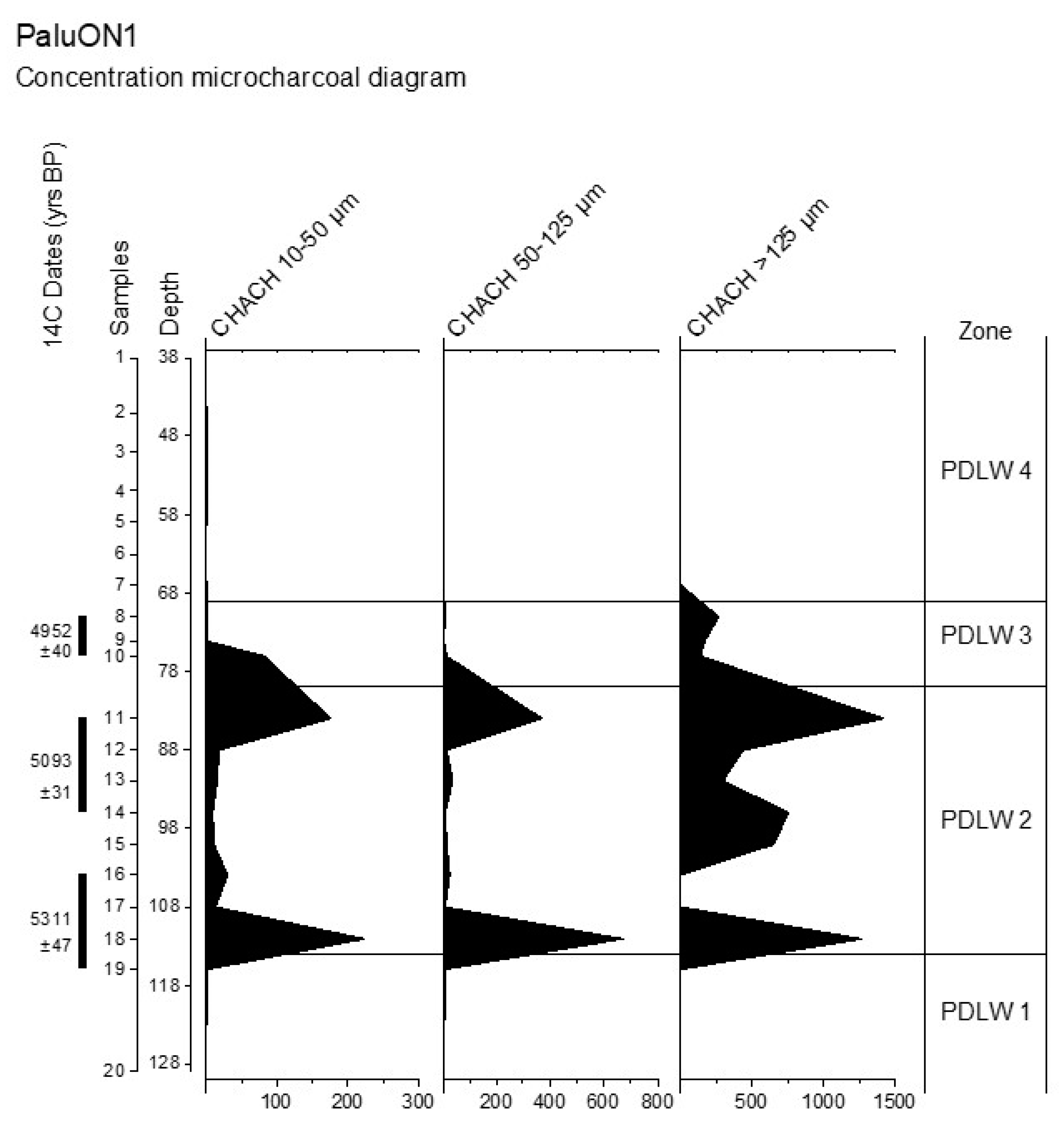
3.4. Microcharcoal Analysis

Microcharcoal analysis was performed at 400× magnification, counting each specimen along 6 lines for each pollen slide. The microcharcoals were divided into 3 size classes, based on the length of the maximum axis (10–50 µm; 50–125 µm; >125 µm) [61,62,63]. Microcharcoals smaller than 10 µm were not considered due to the possible fragmentation that can occur during the extraction procedure (Par. 3.3). The CHAC (concentration expressed as the number of charcoals × cm–3) was calculated for each sample and shown in the Tilia diagrams.

4. Results

4.1. Age Depth-Model

The modelled radiocarbon dates indicate continuous sedimentation starting from c. 7200 cal BP to the present day. At around 73 cm, a significant change in sedimentation rate is visible, which may be somewhat artificial assuming a constant sedimentation rate in the deposit. In fact, it is known that the sedimentation in peat bogs can be erratic due to different hydrological inputs during the year. Nevertheless, this assumption and the current day dating attributed to the surface, as normally applied in standard palaeoecological studies [64], allowed us to obtain an age-depth model consistent with the interdisciplinary data. Although no radiocarbon dating is available for SSUU corresponding to the abandonment phase (SU 3, 4, 6), where no archaeological material was found, the results obtained with the model are compatible with the archaeological chronology of Sector 3. Sedimentation rates are consistently higher during the Neolithic period (c. 4400-3650 BC; Figure 5).

4.2. Pollen and Microcharcoals Analyses

Pollen spectra were obtained from all of the 20 samples analysed (Figure 6 and Figure 7). Pollen was found in a good/very good state of preservation. Few pollen grains were broken, folded or thin; i.e., with light exine. The mean pollen concentration was 180,000 p/g, with the maximum in sample no. 2 at 45 cm (412,000 p/g) and the minimum in no. 11 at 84 cm (45,000 p/g). These values confirm the very good depositional context that permitted the optimal preservation of pollen.
Furthermore, NPPs (Figure 7 were common and well-represented in the samples, and some of them, such as algae and coprophilous fungi, were especially useful for palaeoecological inferences together with pollen results.
Microcharcoals had low concentration in almost all samples (Figure 8). The average CHACH was 363,434 ch. cm−3 with the maximum in sample no. 18 at a depth of 112 cm (2,924,114 ch. cm−3) and the minimum in no. 6 at 63 cm (2356 ch. cm−3).

4.2.1. Pollen Richness and Prevalent Taxa

The floristic list of the site includes 171 taxa, 45 belonging to arboreal plants (AP) and 126 to non-arboreal plants (NAP). The high floristic richness is due to both natural and anthropogenic elements. The average percentage of AP is 46.5%, with the maximum in sample no. 1 (77%) and the minimum in no. 11 (26%). Among AP, the mixed oakwood is prevalent with two main taxa: deciduous Quercus (9.6%) and Corylus avellana (5.8%). The hygrophilous wood is mainly represented by Alnus (17.8%), while conifers prevalently include Pinus (2.4%). Among the NAP, the most represented and interesting taxa are Poaceae wild grass group (12.4%), Cyperaceae (7.7%), Avena/Triticum group (6.1%), Sparganium emersum type (4.5%), Hordeum group (2.2%), Scirpus type (1.5%), Ranunculus acris type (1.2%), Asteraceae (mainly Aster type—1.1%, Artemisia—0.5%, Cichorieae—0.3%), Phragmites (1.1%), Chenopodiaceae/Amaranthaceae (0.8%), Centaurea nigra type (0.6%), Urtica (0.5%), Secale (0.3%) and Cannabis (0.1%).

4.2.2. Non-Pollen Palynomorphs

Among NPPs, the most recurring morphotypes are algal remains and spores of coprophilous fungi. In the spectra, algal remains are represented by HdV 901-Botryococcus (with higher values in samples from no. 1 to no. 7), and HdV 128-Volvocales. Other interesting records are cyanobacteria such as Rivularia type and HdV 601-Anabaena. Microremains from aquatics are the thorns of HdV 137-Ceratophyllum. Moreover, EMA 6, EMA 9, EMA 68, EMA 131 and brachysclereids were also observed. Among coprophilous fungi, there were mainly HdV 55A-Sordaria, HdV 55B-Sordaria, HdV 112-Cercophora type, HdV 113-Sporormiella type, HdV 169-Apiosordaria, HdV 171-Rhytidospora, HdV 368-Podospora type and UG 1066-Delitschia.

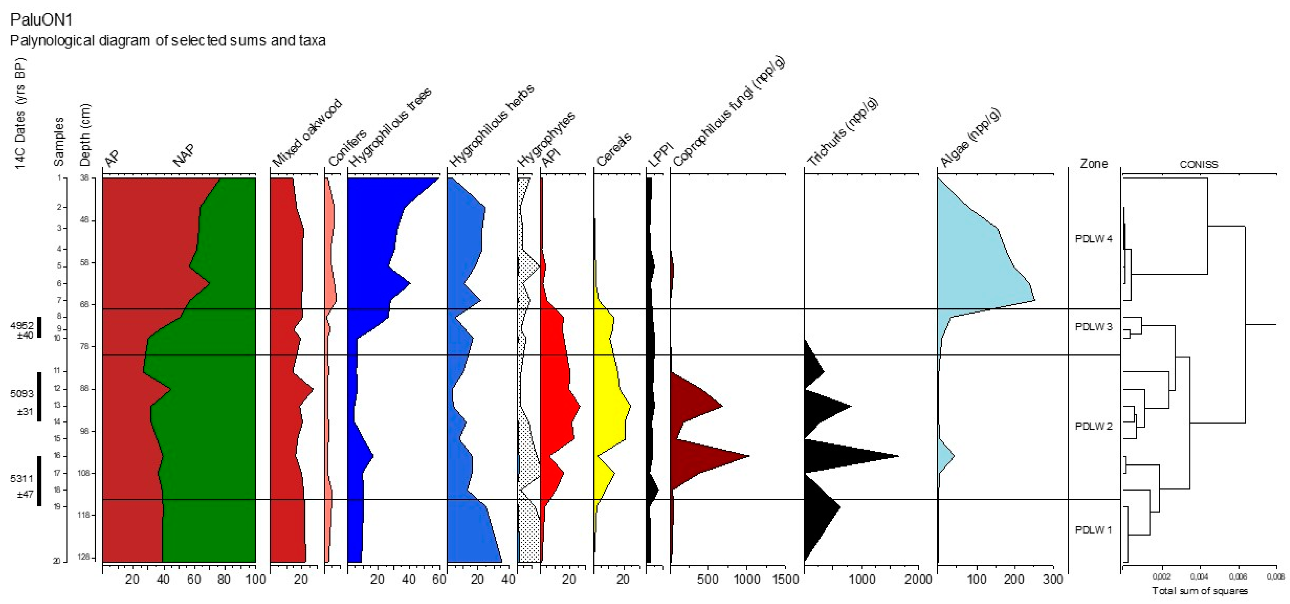
4.2.3. Cluster Analysis and Description of the Pollen Zones (Figure 6 and Figure 7)

Four pollen zones were identified and they are described below, starting from the bottom of the sequence, reporting average values of the main and most representative taxa.

PDLW 1 (Two Samples: From No. 20 to 19; 115–129 cm)

In this zone, the mean percentage of AP and NAP are 39% and 61%, respectively. The main groups represented are the mixed oakwood (22.3%) and the hygrophilous taxa (30.2% herbs plus 9.2% trees). Of the hygrophilous herbs, the most represented are Sparganium emersum type (13.9%) and Cyperaceae (10.4%). API and LPPI groups have low percentages (2.4% and 1.9%, respectively). The average CHACH in this zone is 24,100 ch. cm−3 with a prevalence of the smallest class 10–50 µm (19,016 ch. cm−3).

PDLW 2 (Eight Samples: From No. 18 to 11; 84–114 cm)

In this zone, NAP reach their maximum (64%), almost double that of AP (36%). The most represented AP are again trees of the mixed oakwood (19.4%). Hygrophilous taxa are still present (8.4% trees and 10.1% herbs). Of the NAP, there is an important high presence of cereals that reach 15.6% on average. API and LPPI significantly increase (17.6% and 4%, respectively). Noteworthy is the sporadic presence of Pisum sativum (in two samples) and Linum usitatissimum (in one sample). Coprophilous fungi are very present in this zone. The average CHACH in this zone notably increases to 782,017 ch. cm3 with a prevalence of 10–50 µm and 50–125 µm (632,054 and 143,933 ch. cm−3, respectively).

PDLW 3 (Three Samples: From No. 10 to 8; 69–83 cm)

In this zone, AP again increases to 39%, while NAP starts to decrease (61%). The mixed oakwood is still represented (18.1%) and the hygrophilous trees increase to 16.1%. Among the NAP, hygrophilous herbs are prevalent (11.1%), and cereals are still significantly high (12.1%). API slightly decreases (15.2%) and LPPI remains stable (4.4%). The average CHACH in this zone decreases again to 226,628 ch. cm−3 with a prevalence of the size class 10–50 µm (288,992 ch. cm−3).

PDLW 4 (Seven Samples: From No. 7 to 1; 38–68 cm)

In this zone, AP is at its maximum (64%), and accordingly, NAP are at their minimum (36%). The most represented taxa are Alnus (35.0%) and Cyperaceae (10.6%). In general, hygrophilous taxa are the most represented plants (36.3% trees and 17.6% herbs). Cereals, API and LPPI drastically decrease (1.3%, 2.7%, 2.8%). Algae are particularly high in this zone. The average CHACH in this zone is 9640 ch. cm−3 with a prevalence of the size class 10–50 µm (9089 ch. cm−3).

5. Discussion

Palynological data show a high floristic richness and four local pollen zones throughout the sequence. The two central zone correspond to the human occupation phases of the site documented in Sector 3. Therefore, comparing pollen assemblages from before, during and after the settlement, pollen evidence highlights at least three major phases of environmental changes. In general, the forest cover is rather high in the most ancient and in the most recent phases, suggesting that the landscape was probably more open during the central phase corresponding to the Neolithic settlement, and that the swamp was formed after the Neolithic period. During the settlement phases (archaeological phases 3 to 5; pollen zones PDLW2, PDLW3 and part of PDLW4) there was an increase in plants related to human activities, such as cereals and other synanthropic species.

5.1. The History of Palù di Livenza as Told by PaluON1

5.1.1. The Wood Composition and the Wet Environments during the Pre-Settlement Phase (PDLW1; c. 7141-6374 cal BP/5191-4424 BC)

Palynological data in this zone suggest a good presence of woods as well as wet meadows around the site (Figure 6 and Figure 7). The woods were mainly composed of trees of mixed oakwood (deciduous Quercus, Carpinus betulus, Ostrya carpinifolia/Carpinus orientalis type, Fraxinus excelsior type and Tilia), hygrophilous woods (Alnus, Salix and Populus) and some hilly-mountain trees (such as Pinus, Fagus, Taxus and Betula) (Figure 6a and Figure 7). The presence of pollen from hilly-mountain trees coming from the surrounding mountains (long-transport pollen) suggests that the nearest forest canopy was not closed, otherwise, it would have prevented pollen arrival from a higher elevation. These ideal ecological-vegetation features may have been the reason why Neolithic communities chose this site to settle their village. Wet meadows are affirmed by the presence of Cyperaceae and Sparganium emersum type (Figure 6b and Figure 7). Traces of human presence are weak, mostly represented by some API (cereals, Plantago, Artemisia, Cichorieae and Urtica) and LPPI (mostly Ranuculaceae and Cichorieae). Among NPPs, spores of coprophilous fungi are present in low quantities and microcharcoals are absent. These data agree with Pini [15], who concluded that human imprint is not attested before the onset of the Neolithic village of Palù di Livenza (5960 cal BP), when the area was dominated by the mixed oakwood, hygrophilous trees and wetlands. From this point on, there is a drastic decrease in the wetlands, which marks one of the differences of this zone from the following one (PDLW2).

5.1.2. Human Presence and Activities at the Site (PDLW2, PDLW3; Archaeological Phases 3 to 5, c. 6220-5086 cal BP/4270-3136 BC)

In pollen spectra, human presence is traced by: (i) a decrease of the AP curve, (ii) the high concentration of microcharcoals, (iii) an increase in API and LPPI and (iv) a significant presence of coprophilous fungi. The first AP decrease is recorded at around 92 cm (PDLW2) and then at 76 cm (PDLW3) (Figure 6a). Concurrently, the microcharcoals indicating fires, are high, in particular in PDLW2 (Figure 8). This suggests the occurrence of regional (i.e., small and medium microcharcoals, reaching further distances from their origin) and local fires (i.e., large microcharcoals, less transported [61,63]). The local signal can be related to human activities such as forest clearing for agricultural or pasture purposes, exploitation of the forest resources to obtain wood to build structures as well as for food processing. Previous anthracological studies have attested to the local use of different tree species [16,17,66]. Wood was used for many purposes (e.g., fuel, building material, production of artefacts, etc.). This is exceptionally recorded at the site. Many wooden artefacts have been found during recent excavations in Sector 3 [17]. A similar scenario is reported in the Late Neolithic lakeshore settlement of Stare gmajne at Ljubljansko barje, an important pile-dwelling site in Slovenia [67]. There, a detailed archaeobotanical study reported the use of different woods according to purposes such as building houses, palisades, boats, wheels and carts, weapons and cooking utensils [67,68,69]; concerning the pile construction, widely used species were Quercus sp. and Fraxinus sp., while lesser-used species were poplar, alder, maple, hazelnut and hornbeam [67].
High values of API characterise these pollen zones (Figure 7). In particular, the recurrence of moderate to high values of cereals indicates the existence of cereal cultivation in the area. Cereal pollen percentages depend on agricultural and cereal processing techniques [70] and it is considered a SAT-Strongly Associated Taxa in modern analogue research [71]. Here, cereals (mainly the Avena/Triticum and Hordeum group with some sporadic Panicum, and Secale only in one sample) are documented in all samples throughout the sequence, but they show a massive increase in PDLW2 and PDLW3 (Figure 6b and Figure 7). The recovery of pollen of wild synanthropic plants such as Centaurea nigra type and the weed Papaver rhoeas supports the evidence of cereal fields in the area. Furthermore, a carpological study of six SSUU from previous surveys inside the archaeological site at Palù di Livenza documents the high presence of cereal seeds (Hordeum vulgare, Triticum dicoccum, T. monococcum and T. aestivum/durum) [17]. Noteworthy is the finding of an exceptionally high amount of cereal pollen (19.6% on average) throughout SU 11 (from 96 to 76 cm, PDLW2; Figure 6b and Figure 7), suggesting cereal transport and processing at the site [48,72]. Indeed, archaeological and palynological evidence show that the analysed sequence is located at the core of the settlement area. The high concentration of cereal pollen can identify a specific area devoted to food production. Similarly, at Stare gmajne, Tolar et al. [67] recovered many remains of cereals (particularly chaffs) and reported that the processing of these plants must have taken place within the settlement.
Other important signs of human activities are the findings of Cannabis and Linum usitatissimum that suggest the use, and possibly cultivation, of these plants for textiles. Accordingly, with its low-pollen producer character, Linum usitatissimum was found in the pollen record in very low percentages. Anyway, as already pointed out by Pini [15], it can be assumed to be strongly under-represented in the pollen spectra when compared with the very high number of carpological remains (seeds, capsules) found in the same context [17]. Flax is of particular importance because it belongs to the “initial Neolithic package” coming from the Fertile Crescent [73,74] and only entered into the Italian peninsula from the easternmost part, the Friuli region. In fact, seeds of flax were discovered for the first time in the Neolithic site of Ljubljansko barje in Slovenia [75]. This species is recorded at only a few other Neolithic sites in Italy, such as the early Neolithic site of Sammardenchia and Bannia (Friuli Venezia Giulia) [18,76] and La Marmotta (Anguillara Sabazia, Rome) [77,78].
The presence of some legumes (Pisum) could also be related to human nutrition, although evidence so far (both from palynological and archaeobotanical data) is not yet sufficient to better delineate legume cultivation at Palù di Livenza [36].
Plants typically growing in ruderal and nitrophilous environments such as Artemisia, Solanum nigrum type (typical of the field’s margin or abandoned sites), Plantago, Verbena, Polygonum aviculare type (indicating trampling) and nitrophilous plants (Chenopodiaceae/Amaranthaceae, Rumex, Urtica dioica type) were also found, therefore suggesting the noticeable human impact on the site environs. Among the arboreal plants, Corylus shrubs (which produce edible fruits) were also common. Other woody plants with edible fruits, such as Vitis vinifera and Juglans, were less represented, suggesting a local availability of food resources. Castanea was present in the territory and its pollen probably arrived at the site through long-distance transport. Finally, the LPPI curve and the high peaks of coprophilous fungi (Figure 7) in zone PDLW2 indicate that, in this phase, pastoral activities were an important element of the economy of the village. The combination of LPPI and NPPs, indicating pastures (coprophilous fungi and the endoparasite eggs of Trichuris), is a powerful indicator of local pastoral practices [79]. Furthermore, the finding of Hedera helix in this zone, which is a plant used as winter fodder for cattle ([15,80] Figure 6a) may strengthen the evidence of the presence of herding during the Neolithic phase.

5.1.3. Towards Abandonment and after the Settlement (PDLW4; c. 5086-2873 cal BP/3136-923 BC)

At the end of the sixth millennium BP, a dramatic environmental and cultural change occurred at the site, causing its rapid abandonment. Forest recovery starts after the decline/abandonment of the site at around 60 cm depth (Figure 6a and Figure 7), due to the lower anthropogenic pressure on the area and climatic conditions more favourable to forest development. At Palù di Livenza, the higher forestation rate was mainly due to the growth of Alnus, which marked the expansion of hygrophilous wood. Together with the spread of hygro-hydrophilous herbs (Cyperaceae, Sparganium emersum type), there was the establishment of a wooded swamp. The high percentage of Algae (mainly Botryococcus) supports the pollen evidence of the extent of wetlands. Botryococcus is a planktonic green alga that typically grows in bogs, temporary ponds and other wet environments, and can be considered an indicator of shallow, still water and freshwater input [81,82]. At the same time, cereals and API plants became rare, matching the crop field reduction, whilst coprophilous fungi notably decreased, testifying that lands were not used as pastures either. Altogether, a lesser extent of human influence on the landscape is evident. The gradual abandonment of the site became permanent at c. 4000 years cal BP, from the middle of PDLW4 onwards. The decrease in human activities is also demonstrated by the absence of charcoal fragments in the pollen slides, suggesting that regional and local fire activity drastically decreased during this environmental phase.

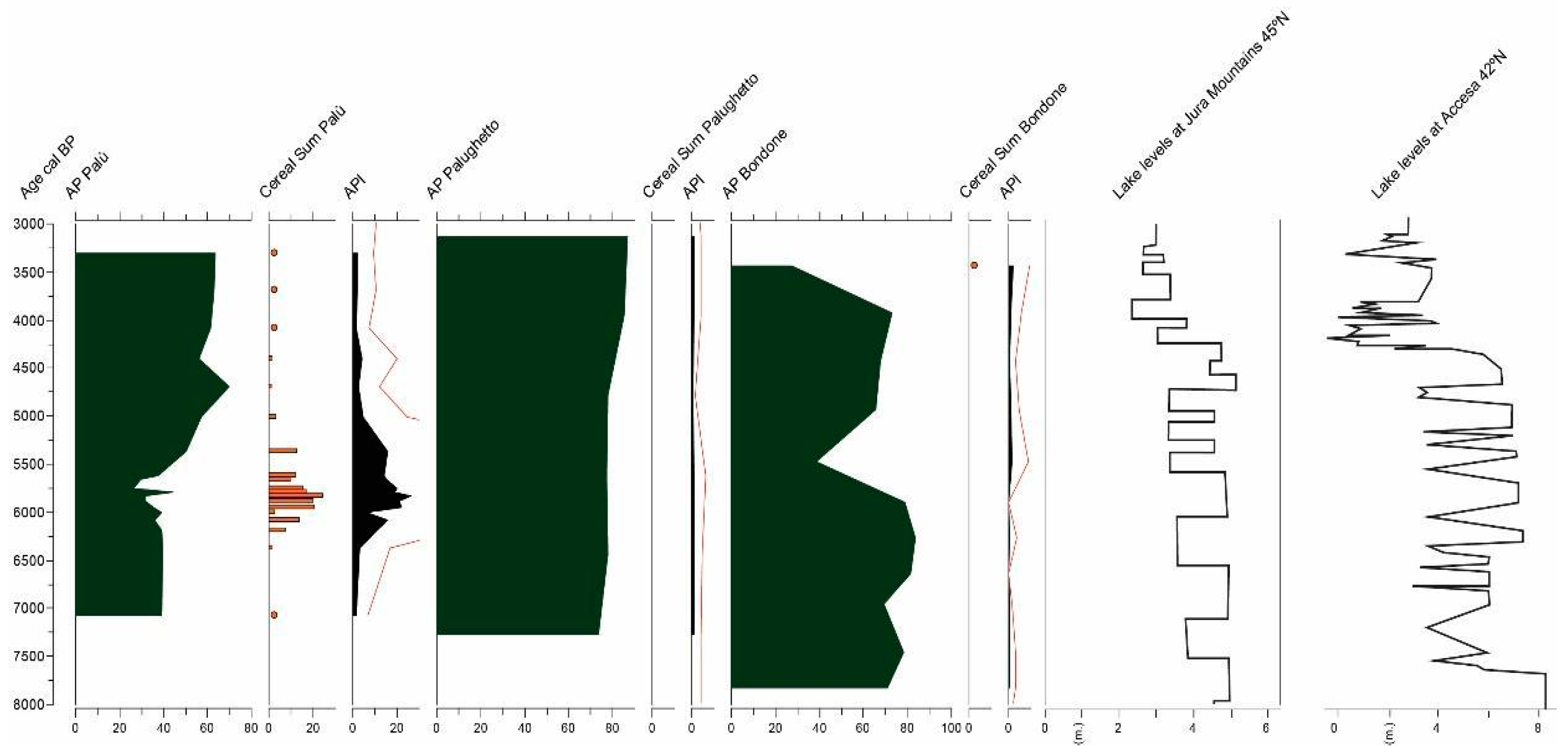
5.2. A Regional Perspective of the Environmental and Climatic Context during the Middle and Late Neolithic

Data from two natural series that can be compared with PaluON1 are available from the Monte Bondone peat bog [59] and at the Palughetto mire [58]. Both are located at higher elevations with respect to Palù di Livenza (at 1550 and 1040 m a.s.l., respectively). A comparison of some of the selected curves obtained from the palynological analysis at the three sites (AP, cereals and API) shows that the forest cover of Palù di Livenza is half that of Bondone and Palughetto (Figure 9). This could be explained by the fact that PaluON1 is an on-site sequence, while the other two are off-site sequences, and thus less disturbed by human presence [13]. However, the wood composition seems to be the same in the three sites, dominated by mixed oakwood and by hygrophilous wood. Higher values of upland trees (e.g., Abies, Picea, Larix, Fagus sylvatica, Betula) are found at Bondone and Palughetto, as a function of their higher elevation. However, they are also present at Palù di Livenza, at a lower percentage, showing a similar composition to the forest at higher altitudes. Despite the fact that at Palughetto the forest cover remains stable during the period analysed, at around 5500 cal BP (the “decline of the Neolithic world” [83]), there is a decrease in the AP curve both at Bondone and Palù di Livenza, indicating forest decline. This may be linked to anthropic pressure on territory that should have influenced environmental dynamics. Human presence and actions during the life of Neolithic villages are well recorded in the pollen diagrams of Palù di Livenza (see API and cereal curves in Figure 7), while it is less evident at the other two sites. Since 4500 cal BP, there is a good recovery of the forest cover at both Bondone and Palù di Livenza, and the lake level appears to be higher, suggesting a wetter climate. Periods with higher lake levels are, in most cases, related to periods of abandonment of lakeshore settlements [84], as also suggested at Palù di Livenza.

6. Conclusions

The PaluON1 record is a key sequence for obtaining information about the environment, the economy and everyday life during the Neolithic period in Northern Italy. From the palynological analysis, the environment before the onset of the settlement was characterised by mixed oakwood forest cover with a high presence of hygrophilous forests and swamps. During the Neolithic period, a marked change in the floristic assemblage was largely due to anthropic pressure and the local economy. The development of agricultural activities especially included cereal fields and plant processing, but also flax and other crop cultivations and animal husbandry/pastural practices. Human influence and settlement favoured the spreading of synanthropic plants and the presence of regional and local fires. After abandonment, probably caused by changing environmental conditions, the area was occupied again by swamps and hygrophilous woods. As reported for other sites in Italy [85], multiple land-use activities (combining crops and pastoral activities) were in use even during the Neolithic period and are highlighted in the pollen spectra of the PaluON1 on-site record. As a future perspective, a comparison of PaluON1 with an off-site core will be useful to clarify the extent to which the floristic/vegetational changes obtained from this study can be attributed to human pressure on the territory and which are instead attributable to regional-level environmental changes.

Author Contributions

Conceptualization, A.M.M.; methodology, A.M.M., P.T., R.M., N.D. and M.B.; software, J.Z. and G.S.-V.; formal analysis, P.T.; investigation, J.Z., A.F., P.T., A.M.M. and R.M.; data curation, J.Z.; writing—original draft preparation, J.Z. and R.M.; writing—review and editing, J.Z., P.T., A.F., N.D., M.B., G.S.-V., A.M.M. and R.M.; visualization, J.Z., G.S.-V., N.D., M.B. and R.M.; supervision, A.M.M. and R.M.; funding acquisition, G.S.-V. All authors have read and agreed to the published version of the manuscript.

Funding

The work of Gabriel Servera-Vives was supported by the European Union’s Horizon 2020 research and innovation program under the Marie Skłodowska-Curie grant agreement No 895735.

Data Availability Statement

The data that support the findings of this study are available from the corresponding author upon request.

Acknowledgments

This project was carried out within an agreement of scientific collaboration between the Soprintendenza Archeologia Belle Arti e Paesaggio del Friuli Venezia Giulia and the Laboratory of Palynology and Palaeobotany of the University of Modena and Reggio Emilia. The study is part of a PhD project started in 2022 in the frame of PON actions (IV.5 «Tematiche Green») and within the activities of the “National Biodiversity Future Center” (NBFC, Palermo, Italy) of the National Recovery and Resilience Plan (NRRP). Special thanks to Marta Mazzanti for the palynological analysis, and to the four anonymous referees for their advice and constructive reviews.

Conflicts of Interest

The authors declare no conflict of interest.

References

  1. Jacomet, S. Plant economy and village life in Neolithic lake dwellings at the time of the Alpine Iceman. Veg. Hist. Archaeobot. 2009, 18, 47–59. [Google Scholar] [CrossRef]
  2. Jacomet, S. Archaeobotany. Analysis of plant remains from waterlogged archaeological site. In The Oxford Handbook of Wetland Archaeology; Menotti, F., O’Sullivan, A., Eds.; Oxford University Press: Oxford, UK, 2013; pp. 497–514. [Google Scholar] [CrossRef]
  3. Clarke, C. Palaeoecological Reconstructions. In The Oxford Handbook of Wetland Archaeology; Menotti, F., O’Sullivan, A., Eds.; Oxford University Press: Oxford, UK, 2013; pp. 538–554. [Google Scholar] [CrossRef]
  4. Magny, M. The contribution of palaeoclimatology to the lake-dwellings. In Living on the Lake in Prehistoric Europe. 150 Years of Lake-Dwelling Research; Menotti, F., Ed.; Routledge: London, UK, 2004; pp. 132–143. [Google Scholar]
  5. Magny, M. Palaeoclimatology and Archaeology in the Wetlands. In The Oxford Handbook of Wetland Archaeology; Menotti, F., O’Sullivan, A., Eds.; Oxford University Press: Oxford, UK, 2013; pp. 585–597. [Google Scholar] [CrossRef]
  6. Matthiesen, H.; Brunning, R.; Carmichael, B.; Hollesen, J. Wetland archaeology and the impact of climate change. Antiquity 2022, 96, 1412–1426. [Google Scholar] [CrossRef]
  7. Pétrequin, P.; Magny, M.; Bailly, M. Habitat lacustre, densité de population et climat—L’exemple du Jura français. In Wetland Economies and Societies, Proceedings of the International Conference, Zurich, Switzerland, 10–13 March 2004; Della Casa, P., Trachsel, M., Eds.; Collectio Archaeologica 3, Chronos: Zürich, Switzerland, 2005; pp. 143–168. [Google Scholar]
  8. Van de Noort, R. The Archaeology of Wetland Landscapes: Method and Theory at the Beginning of the 21st Century. In Handbook of Landscape Archaeology; David, B., Thomas, J., Eds.; Routledge: New York, NY, USA, 2009; pp. 482–489. [Google Scholar]
  9. Menotti, F. Wetland Archaeology and Beyond. Theory and Practice; Oxford University Press: Oxford, UK, 2012. [Google Scholar]
  10. Menotti, F. Wetland Occupations in Prehistoric Europe. In The Oxford Handbook of Wetland Archaeology; Menotti, F., O’Sullivan, A., Eds.; Oxford University Press: Oxford, UK, 2013; pp. 11–25. [Google Scholar] [CrossRef]
  11. Pétrequin, P. Lake-Dwellings in the Alpine Region. In The Oxford Handbook of Wetland Archaeology; Menotti, F., O’Sullivan, A., Eds.; Oxford University Press: Oxford, UK, 2013; pp. 253–267. [Google Scholar] [CrossRef]
  12. Röder, B.; Doppler, T.; Pichler, S.L.; Pollmann, B.; Jacomet, S.; Schibler, J. Beyond the settlement grid: Investigating social differences through archaeobiology in waterlogged sites. J. Neolit. Archaeol. 2013, 15, 12–46. [Google Scholar]
  13. Mercuri, A.M. Genesis and evolution of the cultural landscape in central Mediterranean: The ‘where, when and how’ through the palynological approach. Landsc. Ecol. 2014, 29, 1799–1810. [Google Scholar] [CrossRef]
  14. López-Sáez, J.A.; Abel-Schaad, D.; Pérez-Díaz, S.; Blanco-González, A.; Alba-Sánchez, F.; Dorado, M.; Ruiz-Zapata, B.; Gil-García, M.J.; Gómez-González, C.; Franco-Múgica, F. Vegetation history, climate and human impact in the Spanish Central System over the last 9000 years. Quat. Int. 2014, 353, 98–122. [Google Scholar] [CrossRef]
  15. Pini, R. Late Neolithic vegetation history at the pile-dwelling site of Palù di Livenza (northeastern Italy). J. Quat. Sci. 2004, 19, 769–781. [Google Scholar] [CrossRef]
  16. Castelletti, L.; Leoni, L.; Rottoli, M. Indagini paletnobotaniche al Palù di Livenza (Pordenone). In Atti della Società per la Preistoria e la Protostoria del Friuli-Venezia Giulia, VI (1987–1991); Trieste (TS), Italy, 1992; pp. 61–63. [Google Scholar]
  17. Corti, P.; Martinelli, N.; Rottoli, M.; Tinazzi, O.; Vitri, S. New data on the wooden structures from the pile-dwelling of Palù di Livenza. Preist. Alp. 2001, 33, 73–80. [Google Scholar]
  18. Rottoli, M.; Castiglioni, E. Prehistory of plant growing and collecting in northern Italy, based on seed remains from the early Neolithic to the Chalcolithic (c. 5600–2100 cal BC). Veg. Hist. Archaeobot. 2009, 18, 91–103. [Google Scholar] [CrossRef]
  19. Breda, N. Palù: Paesaggi veneti e culture del nordest tra conservazioni e devastazioni. La Ric. Folk. 2000, 41, 15–23. [Google Scholar] [CrossRef]
  20. Breda, N. D’espaces tabou à zones humides naturalisées le Palù, terrae incognitae de l’Italie du nord-est. In Terres Incertaines: Pour une Anthropologie des Espaces Oublies; Dalla Bernardina, S., Ed.; Presses Universitaires de Rennes: Rennes, Brittany, 2001; pp. 101–116. [Google Scholar]
  21. Bartolomei, G. L’evoluzione geomorfologica del Palù di Livenza (Polcenigo) e l’insediamento preistorico del Neolitico recente. In Insediamenti Preistorici del Friuli Occidentale; Gaspardo, D., Ed.; GEAP: Fiume Veneto, Italy, 1997; pp. 105–108. [Google Scholar]
  22. Bassetti, M.; Cavulli, F. Contributi alle ricerche paleoambientali nel bacino del Palù di Livenza (margine prealpino friulano). In Il Palù alle Sorgenti del Livenza: Ricerca Archeologica e Tutela Ambientale, Conference Proceedings, Polcenigo, Italy, 16 April 1999; Vitri, S., Visentini, P., Eds.; Comunità Pedemontana del Livenza: Polcenigo (PN), Italy, 2002; pp. 103–139. [Google Scholar]
  23. Peresani, M.; Ravazzi, C. Le aree umide come archivi paleoambientali e archeologici tra tardiglaciale e Olocene antico: Esempi e metodi di ricerca sul Cansiglio e al Palù di Livenza. In Il Palù alle Sorgenti del Livenza: Ricerca Archeologica e Tutela Ambientale, Conference Proceedings, Polcenigo, Italy, 16 April 1999; Vitri, S., Visentini, P., Eds.; Comunità Pedemontana del Livenza: Polcenigo (PN), Italy, 2002; pp. 25–60. [Google Scholar]
  24. Vitri, S.; Visentini, P. Il Palù alle Sorgenti del Livenza: Ricerca Archeologica e Tutela Ambientale. Proceedings of the Conference, Polcenigo, Italy, 16 April 1999; Vitri, S., Visentini, P., Eds.; Comunità Pedemontana del Livenza: Polcenigo (PN), Italy, 2002. [Google Scholar]
  25. Blasi, C.; Biondi, E. La flora in Italia. Ministero Dell’ambiente e Della Tutela del Territorio e del Mare; Sapienza Università Editrice: Roma, Italy, 2017. [Google Scholar]
  26. Peretto, C.; Taffarelli, C. Un insediamento del Neolitico Recente al Palù di Livenza (Pordenone). Riv. Di Sci. Preist. 1973, XXVIII, 235–260. [Google Scholar]
  27. Marzatico, F.; Vitri, S. Caneva-Polcenigo, loc. Palù di Livenza. Relaz. Della Soprintend. Per I Beni Ambient. Archit. Archeol. Artist. E Stor. Del Friuli Venezia Giulia 1990, 8, 169–173. [Google Scholar]
  28. Vitri, S. Lo stato delle ricerche nell’abitato palafitticolo del Palù di Livenza: Metodi, risultati, prospettive. In Il Palù alle Sorgenti del Livenza: Ricerca Archeologica e tutela Ambientale, Conference Proceedings, Polcenigo, Italy, 16th April 1999; Vitri, S., Visentini, P., Eds.; Comunità Pedemontana del Livenza: Polcenigo (PN), Italy, 2002; pp. 83–101. [Google Scholar]
  29. Corti, P.; Martinelli, N.; Micheli, R.; Montagnari Kokelj, E.; Petrucci, G.; Riedel, A.; Rottoli, M.; Visentini, P.; Vitri, S. Siti umidi tardoneolitici: Nuovi dati dal Palù di Livenza (Friuli-Venezia Giulia, Italia). In Proceedings of the 13th International Congress of Prehistoric and Protohistoric Sciences, Conference Proceedings, Forlì, Italy, 8–14 September 1996; Abaco: Forlì (FC), Italy, 1998; Volume 3, pp. 263–275. [Google Scholar]
  30. Vitri, S.; Martinelli, N.; Čufar, K. Dati cronologici dal sito di Palù di Livenza. In Il declino del Mondo Neolitico. Ricerche in Italia Centro-Settentrionale fra Aspetti Peninsulari, Occidentali e Nord-Alpini, Conference Proceedings, Pordenone, Italy, 5–7 April 2001; Ferrari, A., Visentini, P., Eds.; Museo Archeologico del Friuli Occidentale: Pordenone, Italy, 2002; pp. 187–198. [Google Scholar]
  31. Corboud, P.; Gowen, M. Protection of the World Heritage against archaeological research: The case of the Prehistoric Pile Dwellings around the Alps registered at UNESCO. Jahrb. Archäologie Schweiz 2016, 99, 157–164. [Google Scholar]
  32. Ruggiero, M.G.; Baioni, M.; Mangani, C. Development of the National Part of the Management Plan: First Actions and Feasibility Studies; Società Archeologica Padana, Quingentole: Mantova (MN), Italy, 2022; ISBN 978-88-946051-5-0. [Google Scholar]
  33. Cesi, A. Siti palafitticoli preistorici dell’arco alpino. Le difficoltà di una candidatura seriale transnazionale complessa. In Le Palafitte: Ricerca, Conservazione, Valorizzazione/The Pile-Dwellings: Investigation, Conservation, Enhancement, Conference Proceedings, Desenzano del Garda, Italy, 6–8 October 2011; Baioni, M., Mangani, C., Ruggiero, M.G., Eds.; SAP—Società Archeologica: Quingentole (Mantua), Italy, 2018; pp. 19–23. [Google Scholar]
  34. Andreetta, A. Siti palafitticoli preistorici dell’arco alpino: Patrimonio dell’umanità! Dalla candidatura al riconoscimento. In Le Palafitte: Ricerca, Conservazione, Valorizzazione/The Pile-Dwellings: Investigation, Conservation, Enhancement, Conference Proceedings, Desenzano del Garda, Italy, 6–8 October 2011; Baioni, M., Mangani, C., Ruggiero, M.G., Eds.; SAP—Società Archeologica: Quingentole (Mantua), Italy, 2018; pp. 19–23. [Google Scholar]
  35. Micheli, R. Abitare le aree umide della pedemontana veneto-friulana alla fine del Neolitico: Nuovi dati dal Palù di Livenza. In Dalla Preistoria all’Alto Medioevo nell’Antico Cenedese; Arnosti, G., Riviera, G., Schincariol, F., Eds.; Centro di Antichità Altoadriatiche. Editreg: Trieste (TS), Italy, 2018; Volume 89, pp. 75–96. [Google Scholar]
  36. Micheli, R.; Bassetti, M.; Degasperi, N.; Fozzati, L.; Martinelli, N.; Rottoli, M. Nuove ricerche al Palù di Livenza: Lo scavo del Settore 3. In Preistoria e Protostoria del Caput Adriae, Studi di Preistoria e Protostoria; Borgna, E., Cassola Guida, P., Corazza, S., Eds.; IIPP: Firenze, Italy, 2018; pp. 481–490. [Google Scholar]
  37. Micheli, R.; Bassetti, M.; Degasperi, N. Nuove indagini e prospettive della ricerca nella palafitta preistorica del Palù di Livenza. Quad. Friulani Archeol. 2019, XXIX, 37–48. [Google Scholar]
  38. Micheli, R.; Bassetti, M.; Degasperi, N. Palù di Livenza: Un insediamento palafitticolo pluristratificato del Neolitico nella Pedemontana pordenonese. Sibrium, 2019; in press. [Google Scholar]
  39. Haslett, J.; Parnell, A.C. A simple monotone process with application to radiocarbon-dated depth chronologies. J. R. Stat. Soc. 2008, 57, 399–418. Available online: https://rss.onlinelibrary.wiley.com/doi/full/10.1111/j.1467-9876.2008.00623.x (accessed on 1 February 2023). [CrossRef]
  40. R Core Team. R: A Language and Environment for Statistical Computing; R Foundation for Statistical Computing: Vienna, Austria, 2020; Available online: https://www.R-project.org/ (accessed on 1 February 2023).
  41. Ramsey, C.B. Bayesian Analysis of Radiocarbon Dates. Radiocarbon 2009, 51, 337–360. [Google Scholar] [CrossRef]
  42. Reimer, P.; Austin, W.; Bard, E.; Bayliss, A.; Blackwell, P.; Ramsey, C.B.; Butzin, M.; Cheng, H.; Edwards, R.L.; Friedrich, M.; et al. The IntCal20 Northern Hemisphere Radiocarbon Age Calibration Curve (0–55 cal kBP). Radiocarbon 2020, 62, 725–757. [Google Scholar] [CrossRef]
  43. Florenzano, A.; Mercuri, A.M.; Pederzoli, A.; Torri, P.; Bosi, G.; Olmi, L.; Rinaldi, R.; Bandini Mazzanti, M. The significance of intestinal parasite remains in pollen samples from Medieval pits in the Piazza Garibaldi of Parma, Emilia Romagna, Northern Italy. Geoarchaeology 2012, 27, 34–47. [Google Scholar] [CrossRef]
  44. Moore, P.D.; Webb, J.A.; Collins, M.E. Pollen Analysis, 2nd ed.; Blackwell Sc. Publ.: Oxford, UK, 1991. [Google Scholar]
  45. Reille, M. Pollen et Spores d’Europe et d’Afrique du Nord; Laboratoire de Botanique Historique et Palinologie: Marseille, France, 1992. [Google Scholar]
  46. Reille, M. Pollen et Spores d’Europe et d’Afrique du Nord; Laboratoire de Botanique Historique et Palinologie: Marseille, France, 1995. [Google Scholar]
  47. Reille, M. Pollen et Spores d’Europe et d’Afrique du Nord; Laboratoire de Botanique Historique et Palinologie: Marseille, France, 1998. [Google Scholar]
  48. Mercuri, A.M.; Bandini Mazzanti, M.; Florenzano, A.; Montecchi, M.C.; Rattighieri, E.; Torri, P. Anthropogenic Pollen Indicators (API) from archaeological sites as local evidence of human-induced environments in the Italian peninsula. Ann. Bot. Roma 2013, 3, 143–153. [Google Scholar] [CrossRef]
  49. Mazier, F.; Galop, D.; Brun, C.; Buttler, A. Modern pollen assemblages from grazed vegetation in the western Pyrenees, France: A numerical tool for more precise reconstruction of past cultural landscapes. Holocene 2006, 16, 91–103. [Google Scholar] [CrossRef]
  50. Mazier, F.; Galop, D.; Gaillard, M.J.; Rendu, C.; Cugny, C.; Legaz, A.; Peyron, O.; Buttler, A. Multidisciplinary approach to reconstructing local pastoral activities: An example from the Pyrenean Mountains (Pays Basque). Holocene 2009, 19, 171–188. [Google Scholar] [CrossRef]
  51. Florenzano, A.; Marignani, M.; Rosati, L.; Fascetti, S.; Mercuri, A.M. Are Cichorieae an indicator of open habitats and pastoralism in current and past vegetation studies? Plant Biosyst. 2015, 149, 154–165. [Google Scholar] [CrossRef]
  52. Van Geel, B.; Klink, A.G.; Pals, J.P.; Wiegers, J. An upper Eemian lake deposit from Twente, eastern Netherlands. Rev. Palaeobot. Palynol. 1986, 47, 31–61. [Google Scholar] [CrossRef]
  53. Shumilovskikh, L.S.; van Geel, B. Non-Pollen Palynomorphs. In Handbook for the Analysis of Micro-Particles in Archaeological Samples; Interdisciplinary Contributions to Archaeology; Henry, A.G., Ed.; Springer: Cham, Switzerland, 2020. [Google Scholar] [CrossRef]
  54. Grimm, E.D. TGView; Illinois State Museum: Springfield, IL, USA, 2004. [Google Scholar]
  55. Grimm, E.C. CONISS: A FORTRAN 77 program for stratigraphically constrained cluster analysis by the method of incremental sum of squares. Comput. Geosci. 1987, 13, 13–35. [Google Scholar] [CrossRef]
  56. Williams, J.; Grimm, E.; Blois, J.; Charles, D.; Davis, E.; Goring, S.; Russell, W.G.; Smith, A.J.; Anderson, M.; Arroyo-Cabrales, J.; et al. The Neotoma Paleoecology Database, a multiproxy, international, community-curated data resource. Quat. Res. 2018, 89, 156–177. [Google Scholar] [CrossRef]
  57. Juggins, S. C2 Version 1.5 User Guide. Software for Ecological and Palaeoecological Data Analysis and Visualisation; Newcastle University: Newcastle upon Tyne, UK, 2007; 73p. [Google Scholar]
  58. Vescovi, E.; Ravazzi, C.; Arpenti, E.; Finsinger, W.; Pini, R.; Valsecchi, V.; Wick, L.; Ammann, B.; Tinner, W. Interactions between climate and vegetation during the Lateglacial period as recorded by lake and mire sediment archives in Northern Italy and Southern Switzerland. Quat. Sci. Rev. 2007, 26, 1650–1669. [Google Scholar] [CrossRef]
  59. Grüger, J. Untersuchungen zur spätglazialen und frühpostglazialen Vegetationsentwicklung der Südalpen im Umkreis des Gardassees. Bot. Jahrbücher Für Syst. Pflanzengesch. Und Pflanzengeogr. 1968, 88, 163–199. [Google Scholar]
  60. Magny, M.; Combourieu-Nebout, N.; de Beaulieu, J.L.; Bout-Roumazeilles, V.; Colombaroli, D.; Desprat, S.; Francke, A.; Joannin, S.; Ortu, E.; Peyron, O.; et al. North–south palaeohydrological contrasts in the central Mediterranean during the Holocene: Tentative synthesis and working hypotheses. Clim. Past 2013, 9, 2043–2071. [Google Scholar] [CrossRef]
  61. Mercuri, A.M.; Florenzano, A.; Terenziani, R.; Furia, E.; Dallai, D.; Torri, P. Middle-to late-Holocene fire history and the impact on Mediterranean pine and oak forests according to the core RF93-30, central Adriatic Sea. Holocene 2019, 29, 1362–1376. [Google Scholar] [CrossRef]
  62. Conedera, M.; Krebs, P.; Valese, E.; Cocca, G.; Schunk, C.; Menzel, A.; Vacik, H.; Cane, D.; Japelj, A.; Muri, B.; et al. Characterizing Alpine pyrogeography from fire statistics. Appl. Geogr. 2018, 98, 87–99. [Google Scholar] [CrossRef]
  63. Whitlock, C.; Larson, C. Charcoal as a fire proxy. In Tracking Environmental Change Using Lake Sediments; Volume 3: Terrestrial, Algal, and Siliceous Indicators; Smol, J.P., Birks, H.J.B., Last, W.M., Eds.; Kluwer Academic Publishers: Dordrecht, The Netherlands, 2001; pp. 75–97. [Google Scholar]
  64. Lacourse, T.; Gajewski, C. Current practices in building and reporting age-depth models. Quat. Res. 2020, 96, 28–38. [Google Scholar] [CrossRef]
  65. Pignatti, S. Note critiche sulla flora d’Italia. VII. Supplemento. Plant Biosystem, 116(1–2), 93–95. Pignatti, S. Note critiche sulla flora d’Italia. VII. Supplemento. Plant Biosystem 1982, 116, 93–95. [Google Scholar]
  66. Rottoli, M.; Bassetti, M.; Degasperi, N.; Martinelli, N.; Micheli, R. Agriculture, forestry resources and Late Neolithic daily life at the pile-dwelling site of Palù di Livenza (NE Italy). Hum. Environ. Sustain. 2018, 33, 33–35. [Google Scholar]
  67. Tolar, T.; Jacomet, S.; Velušček, A.; Čufar, K. Plant economy at a late Neolithic lake dwelling site in Slovenia at the time of the Alpine Iceman. Veg. Hist. Archaeobot. 2011, 20, 207–222. [Google Scholar] [CrossRef]
  68. Velušček, A. Past and present lake-dwelling studies in Slovenia, Ljubljansko barje (the Ljubljana Marsh). In Living on the Lake in Prehistoric Europe, 150 Years of Lakedwelling Research; Menotti, F., Ed.; Routledge: London, UK, 2004; pp. 69–82. [Google Scholar]
  69. Velušček, A. Stare gmajne pile-dwelling settlement and its era. In Stare Gmajne Pile-Dwelling Settlement and Its Era, The Ljubljansko Barje in the 2nd Half of the 4th Millennium B.C.; Velušček, A., Ed.; Opera Instituti Archaeologici Sloveniae 16, Založba ZRC: Ljubljana, Slovenia, 2009; pp. 11–34. [Google Scholar]
  70. Hall, V.A. The role of harvesting techniques in the dispersal of pollen grains of Cerealia. Pollen Spores 1988, 30, 265–270. [Google Scholar]
  71. Brun, C.; Dessaint, F.; Richard, H.; Bretagnolle, F. Arable-weed flora and its pollen representation: A case study from the eastern part of France. Rev. Palaeobot. Palynol. 2007, 146, 29–50. [Google Scholar] [CrossRef]
  72. Bosi, G.; Bandini Mazzanti, M.; Florenzano, A.; Massamba N’siala, I.; Pederzoli, A.; Rinaldi, R.; Torri, P.; Mercuri, A.M. Seeds/fruits, pollen and parasite remains as evidence of site function: Piazza Garibaldi e Parma (N Italy) in Roman and Mediaeval times. J. Archaeol. Sci. 2011, 38, 1621–1633. [Google Scholar] [CrossRef]
  73. Zohari, D.; Hopf, M. Domestication of Plants in the Old World. In The Origin and Spread of Cultivated Plants in West Asia, Europe and the Nile Valley, 3rd ed.; Oxford University Press: Oxford, UK, 2000; pp. 83–88. [Google Scholar]
  74. Mottes, E.; Petrucci, G.; Rottoli, M.; Visentini, P. Evolution of the Square Mouthed Pottery culture in Trentino-Alto Adige, Veneto and Friuli: Cultural, chronological, palaeoeconomic and environmental aspects. Gortania 2009, 31, e124. [Google Scholar]
  75. Tolar, T.; Velušček, A.; Patrun, N. Discovery of Flax (Linum usitatissimum) at Ljubljansko Barje, Slovenia. Historia Antiqua 2009, 18, 187–194. [Google Scholar]
  76. Visentini, P. I siti di Bannia-Palazzine di Sopra e Palù di Livenza nel quadro del Neolitico recente e tardo del Friuli. In Il Declino del Mondo Neolitico. Ricerche in Italia Centro-Settentrionale Fra Aspetti Peninsulari, Occidentali e Nord-Alpini. Atti del Convegno, Pordenone, Italy, 5–7 April 2001; Quaderni del Museo Archeologico del Friuli occidentale; Ferrari, A., Visentini, P., Eds.; Forum: Udine (UD), Italy, 2002; pp. 199–212. [Google Scholar]
  77. Fugazzola Delpino, M.A.; D’Eugenio, G.; Pessina, A. La Marmotta (Anguillara Sabazia, RM). Scavi 1989. Un abitato perilacustre di età neolitica. Bull. Paletnol. 1993, 84, 181–304. [Google Scholar]
  78. Rottoli, M. Zafferanone selvatico (Carthamus lanatus) e cardo della Madonna (Silybum marianum), piante raccolte o coltivate nel Neolitico antico a “La Marmotta”? Bull. Paletnol. 2002, 91–92, 47–61. [Google Scholar]
  79. Florenzano, A. The history of pastoral activities in S Italy inferred from palynology: A long-term perspective to support biodiversity awareness. Sustainability 2019, 11, 404. [Google Scholar] [CrossRef]
  80. Karg, S. Winter- and spring-foddering of sheep/goat in the Bronze Age site of Fiave`-Carera, Northern Italy. Environ. Archaeol. 1998, 1, 87–94. [Google Scholar] [CrossRef]
  81. Shumilovskikh, L.; O’Keefe, J.; Marret, F. An overview of the taxonomic groups of NPPs. In Applications of Non-Pollen Palynomorphs: From Palaeoenvironmental Reconstructions to Biostratigraph; Marret, F., O’Keefe, J., Osterloff, P., Pound, M., Shumilovskikh, L., Eds.; Geological Society, London, Special Publications: London, UK, 2021; p. 511. [Google Scholar] [CrossRef]
  82. Komárek, J.; Marvan, P. Morphological differences in natural populations of the genus Botryococcus (Chlorophyceae). Arch. Für Protistenkd. 1992, 141, 65–100. [Google Scholar] [CrossRef]
  83. Ferrari, A.; Visentini, P. Il declino del mondo neolitico. Ricerche in Italia centro-settentrionale fra aspetti peninsulari, occidentali e nord-alpini, Atti del Convegno, Pordenone, Italy, 5–7 April 2001; Quaderni del Museo Archeologico del Friuli occidentale; Forum: Udine (UD), Italy, 2002. [Google Scholar]
  84. Arbogast, R.M.; Jacomet, S.; Magny, M.; Schibler, J. The significance of climate fluctuations for lake level changes and shifts in subsistence economy during the late Neolithic (4300–2400 BC) in central Europe. Veg. Hist. Archaeobot. 2006, 15, 403–418. [Google Scholar] [CrossRef]
  85. Mercuri, A.M.; Florenzano, A.; Burjachs, F.; Giardini, M.; Kouli, K.; Masi, A.; Picornell-Gelabert, L.; Revelles, J.; Sadori, L.; Servera-Vives, G.; et al. From influence to impact: The multifunctional land use in Mediterranean prehistory emerging from palynology of archaeological sites (8.0–2.8 ka BP). Holocene 2019, 29, 830–846. [Google Scholar] [CrossRef]
Figure 1. Palù di Livenza: (a) location map of the archaeological site (yellow star); (b) position of the site in the Friuli Venezia Giulia region; (c) location of the region in northeastern Italy, with another two sites cited in the text (yellow point represents Monte Bondone (TN), and yellow triangle represents the Palughetto mire (BL)). Source: ESRI, Maxar, Earthstar Geographics and the GIS User Community.
Quaternary 06 00034 g001
Figure 2. Palù di Livenza: (a) location of the pile-dwelling site in the wetland area; (b) the artificial channel with the location of Sectors 1–3 (archive SABAP-FVG). For details of Sector 3 structures, see Figure 3.
Quaternary 06 00034 g002
Figure 3. Palù di Livenza, a multi-phase Neolithic pile-dwelling site: palimpsest of the wooden foundation structures identified in Sector 3 and PaluON1 sampling location in Section 4 (archive SABAP-FVG).
Quaternary 06 00034 g003
Figure 4. Palù di Livenza: the sequence PaluON1 (Sector 3, Section 4, SW corner) with the position of the 20 pollen samples taken. The light blue layers correspond to the archaeological phase 4, while the red layers correspond to the archaeological phase 5.
Quaternary 06 00034 g004
Figure 5. Palù di Livenza: age-depth model elaborated with BChron package using R software. The three radiocarbon dates, with Lab code and the dated material, are shown in the table on the right.
Quaternary 06 00034 g005
Figure 6. Palù di Livenza: percentage pollen diagram of selected taxa of AP (a) and NAP (b). Grey curves represent 10% exaggeration. [Analysts: Paola Torri and Marta Mazzanti].
Quaternary 06 00034 g006
Figure 7. Palù di Livenza: pollen diagram representing selected sums (pollen sums percentages and NPPs concentrations), useful for palaecological reconstruction: AP (Arboreal Pollen)/NAP (Non Arboreal Pollen) ratio; the mixed oakwood (which includes: Acer campestre type, Carpinus betulus, Corylus avellana, deciduous Quercus, Fraxinus excelsior, Tilia, Ulmus); conifers (Abies, Picea, Pinus, Taxus); hygrophilous trees (Alnus, Salix, Populus); hygrophilous herbs (Cyperaceae, Phragmites type, Lythrum, Sparganium emersum type, Typha latifolia type) and hydrophytes (Alisma, Sagittaria, Lemna, Callytriche, Hydrocharis, Myriophyllum, Nuphar, Potamogenton [65]); API (Artemisia, Centaurea, Plantago, Trifolium, Urtica, cereals, and Cichorieae sensu [48,51]); cereals (Panicum, Hordeum group, Avena/Triticum group); LPPI (Asteraceae, Cirsium, Trifolium type, Ranunculaceae, Galium type; Potentilla type and Stellaria type [49,50]); coprophilous fungi (Sordaria type, Cercophora type, Sporormiella type, Apiosordaria, Rhytidospora, Podospora type, Delitschia), parasite eggs (Trichuris) and Algae sensu lato (including algae and cyanobacteria). [Analysts: Paola Torri and Marta Mazzanti].
Quaternary 06 00034 g007
Figure 8. Palù di Livenza: microcharcoal analysis. The particles were divided into three size classes and their concentration (CHACH) was expressed as ch. cm−3.
Quaternary 06 00034 g008
Figure 9. Integrated pollen and paleohydrological diagram regarding anthropogenic and climate trends from Palù di Livenza (this study), Palughetto [58], Bondone [59], Jura Mountains and Lake Accesa [60]. An x5 exaggeration multiplier is applied to API curves (empty curves) for better readability.
Quaternary 06 00034 g009
Table 1. Palù di Livenza: List of samples from top (1) to bottom (20) with the sampling depth, the Stratigraphical Unit and the phase they represent.
SampleDepth (cm)SUPhase
1
2
3
38
45
50
3Wooden swamp/Peat Bog
4
5
55
59
4Wooden swamp
6
7
8
63
67
71
6Mud deposit/high water level
9
10
74
76
7Archaeological phase 5b
11
12
13
14
84
88
92
96
11Archaeological phase 5a
1510013/12Archaeological phase 4
16
17
18
19
104
108
112
116
14
14 bottom
Archaeological phase 3
2012923Pre-settlement
Disclaimer/Publisher’s Note: The statements, opinions and data contained in all publications are solely those of the individual author(s) and contributor(s) and not of MDPI and/or the editor(s). MDPI and/or the editor(s) disclaim responsibility for any injury to people or property resulting from any ideas, methods, instructions or products referred to in the content.

