1. Introduction
Digital Surface Models (DSMs) are foundational elements of geospatial datasets that are essential for applications ranging from urban planning and infrastructure development to environmental management and disaster mitigation. These models are essential for providing accurate representations of the Earth’s surface, including vegetation and human-made structures, and are utilized for diverse purposes including flood modeling, forestry management, hydrology and water management, and urban morphology studies [
1,
2]. Traditionally, DSMs have been developed using a combination of active and passive remote sensing technologies, such as satellite imagery, LiDAR (Light Detection and Ranging), and photogrammetry. Active sensing technologies like LiDAR offer high accuracy and precision by emitting laser light pulses and measuring the time each pulse takes to return, thus capturing fine topographical details regardless of lighting conditions or vegetation cover [
3].
Conversely, passive systems, particularly those utilizing visible spectrum cameras, are favored for their cost-effectiveness, accessibility, and efficiency in capturing detailed topographic data [
4]. These systems depend on ambient light to gather imagery, which is then processed using photogrammetric techniques to produce DSMs. Recent advancements in Unmanned Aerial Vehicle (UAV) technology have significantly enhanced the capabilities of passive systems, allowing for more frequent and detailed data collection at lower costs. One of the unique advantages of UAV data is its ability to provide high-resolution imagery, enabling detailed analyses of both small-scale and large-scale phenomena.
Additionally, UAVs can be deployed on-demand and flown at specific altitudes and times, offering greater flexibility and precision in data acquisition. In agriculture, for example, UAVs are used for crop health monitoring through multispectral imaging, while in forestry, they facilitate tree species classification and disease detection. Similarly, in construction and urban planning, UAVs enable the real-time monitoring of site development and structural integrity. UAVs equipped with high-resolution cameras can also rapidly cover large areas, providing a considerable improvement over traditional ground-based surveys and manned aircraft, particularly in inaccessible or hazardous locations [
5]. Previous studies have validated the effectiveness of UAV-based SfM photogrammetry in generating accurate elevation models under varying terrain and operational settings [
6]. emphasized that UAV type, flight altitude, and overlap ratios play a critical role in determining model accuracy, while [
7] highlighted the importance of GCP density and optimized flight planning in enhancing DSM precision. These findings provide a solid foundation for exploring DSM generation under less conventional conditions, such as nighttime thermal imaging.
Thermal mapping is becoming increasingly important in civilian applications because thermal sensors can operate effectively in conditions where visible cameras cannot, such as fog and night [
8]. Thermal UAV imaging can identify and analyze heat patterns associated with different land surfaces, which is critical for environmental monitoring, studying urban heat islands, and aiding energy conservation in urban planning [
9,
10].
The incorporation of thermal imaging cameras on UAVs has expanded their applications, allowing thermal infrared images to be captured for a variety of purposes. Thermal infrared imaging, which detects radiation emitted from objects above absolute zero, offers a non-contact, non-destructive, and non-invasive method to assess and map surface temperatures, enhancing both the accuracy and extent of terrain modeling [
11]. Thermal imaging has found reliable applications across various sectors, notably in building diagnostics, where it aids in energy audits and the identification of structural defects [
12,
13]. It has also been instrumental in archaeological studies for mapping ruins and in agriculture for assessing plant health and water stress [
14,
15,
16]. Recent studies have highlighted the potential of integrating thermal and visible spectrum imagery to enhance environmental monitoring and disaster management efforts [
17]. Utilizing thermal imaging during nocturnal hours minimizes atmospheric interference and maximizes thermal contrast, thereby improving the quality of data for urban planning, environmental conservation, and historical preservation. In addition to advancing geospatial data collection, this approach opens up new opportunities for thermal imaging to be used in different nighttime surveillance activities [
18,
19,
20].
The integration of thermal cameras with UAVs has added a new dimension to DSM generation, especially for applications requiring nighttime data collection or analysis of the terrain’s thermal properties. This capability allows the imaging different types of surfaces—like rock, vegetation, water, and built-up areas after sunset [
21]. Furthermore, the development of sophisticated image processing algorithms and computer vision techniques has greatly improved researchers’ abilities to automatically extract more accurate and detailed DSMs from both active and passive sensor data, reducing the manual effort required for corrections [
22].
This study explores the innovative application of nighttime-UAV-based thermal imaging for high-resolution DSM generation, taking advantage of the unique benefits of nighttime data collection. It operates under the hypothesis that aerial images captured at night, with reduced solar interference and distinct thermal signatures of various surfaces that become more pronounced at lower ambient temperatures, can effectively meet photogrammetric requirements for DSM production. These conditions are particularly advantageous for distinguishing terrain features that are less discernible in RGB (visible range/red–green–blue) imaging during daylight. This study fills a significant gap in the use of UAV thermal data for nighttime DSM generation, which remains underexplored in the remote sensing literature. This investigation represents a foundational exploration in the emerging field of nighttime thermal photogrammetry for terrain modeling, establishing baseline methodologies and accuracy benchmarks that will inform subsequent research phases. Accordingly, the following research questions (RQs) are posed:
RQ1: Can DSMs be effectively produced using aerial photographs taken at night with a thermal-camera-equipped UAV?
RQ2: How accurate is the height information provided by the produced DSMs, as determined by the Root Mean Squared Error (RMSE) for the Z coordinate?
RQ3: From the end user’s perspective, what is the correlation of the produced thermal DSM with a reference DSM, considering its potential use as a surface model?
2. Thermal Imaging Foundations for DSM Generation
Traditionally used to capture temperature variations across surfaces, thermal imaging records infrared radiation emitted from objects, which varies with their temperature [
23]. This capability is typically used to monitor thermal properties across diverse fields such as environmental studies, engineering, and healthcare [
24,
25,
26]. However, the application of thermal imaging in generating Digital Elevation Models (DEMs) or DSMs is not straightforward as these models usually represent the terrain’s elevation rather than its temperature [
27].
The adaptation of thermal imaging for DSM generation hinges on the principle that thermal properties of surfaces at night can indirectly inform about their elevation characteristics in specific scenarios [
28,
29]. For instance, different types of surfaces—like rock, vegetation, water, and built-up areas—emit varying amounts of thermal radiation based on their specific heat capacities and cool at different rates after sunset [
21]. These variations can subtly indicate the surface’s spatial and material characteristics, which can be algorithmically correlated with elevation in certain contexts.
In practical terms, DSMs are generated not directly from the raw temperature values recorded in thermal images but from the grayscale values of the pixels in these images. These grayscale values, which represent thermal intensities, are processed similarly to how visible light images are used in photogrammetry [
30]. Through the use of structure-from-motion (SfM) techniques, originally designed to interpret visual cues in images, thermal imagery can be utilized to reconstruct 3D models. SfM algorithms can use the temperature gradients captured as grayscale values in the imagery as proxies for physical structure, especially when thermal images are taken under uniform conditions and calibrated accurately for ambient temperature influences.
Furthermore, by using ground control points (GCPs) that are identifiable in the thermal spectrum, the elevation data derived from thermal images can be georeferenced and calibrated against known elevations, thereby enhancing the DSM’s accuracy [
31]. This process requires the use of advanced image processing and calibration techniques to account for the characteristics of thermal cameras. Factors such as emissivity, environmental temperature, and relative humidity must be adjusted for as they can influence the interpretation of raw thermal data.
Thus, while thermal cameras primarily capture temperature data, through careful calibration, integration with SfM methodologies, and geospatial analysis, these data can be transformed into useful spatial models that describe the surface geometry. This innovative application highlights the potential of thermal imaging to extend beyond traditional temperature mapping, providing valuable insights into terrain modeling where typical optical methods might be less effective [
22].
While thermal DSMs are a well-established tool in various applications, their utilization specifically for nighttime data collection remains a relatively novel approach. Contrary to perceptions that may suggest widespread use, nighttime thermal DSMs are particularly groundbreaking due to their ability to provide valuable data under conditions where traditional methods fall short. The benefits of nighttime DSM generation and its impact on operational efficiency and planning capabilities in various areas are therefore important to mention. Thermal DSMs are especially valuable in scenarios where traditional daylight data collection is impractical or insufficient. For instance, in disaster response and management, the ability to rapidly assess terrain changes and identify hotspots can be critical for directing emergency services and aid during night hours when visibility is limited [
32]. Similarly, in security and surveillance applications, nighttime thermal DSMs enable the continuous monitoring of sensitive areas without the need for illumination, maintaining stealth while ensuring detailed spatial awareness [
27]. Environmental monitoring also benefits from this approach, especially for observing nocturnal wildlife or thermal phenomena that are more distinct at night [
33]. In agriculture and forestry, thermal DSMs can identify variations in soil temperature and moisture levels that are critical for managing irrigation and assessing frost risks overnight [
34]. Additionally, urban heat island studies often require data on how heat is distributed across city landscapes during the cooler hours, which can inform energy efficiency strategies and urban planning decisions [
35].
In addition, thermal DSMs have the potential to expand applications across multiple sectors to improve both operational efficiency and planning capabilities. Emergency planning and infrastructure assessment, for example, utilize these DSMs to ensure the structural safety of buildings post-disaster and to strategize emergency responses effectively [
36]. In environmental conservation, thermal DSMs are instrumental in protecting ecosystems by providing data on habitat conditions that only manifest at night, such as the activities of nocturnal species [
37]. Urban planners use these models to optimize lighting designs that minimize light pollution and improve the energy efficiency of heating, ventilation, and air conditioning systems in buildings [
38]. Furthermore, in scientific research, these models offer unique insights into geological and hydrological phenomena, facilitating studies that require precise thermal data to track changes over time or under specific environmental conditions [
39].
While conventional thermal imaging applications often rely solely on 2D imagery, generating DSMs from thermal data offers added value for nighttime or low-visibility operations. Potential applications include post-disaster terrain analysis, emergency mapping, archaeological prospecting under light-restricted conditions, and nocturnal surveillance tasks. In such scenarios, the geometric structure provided by a thermal DSM complements temperature information and enhances spatial interpretation.
3. Methodology
As is known, aluminum sheets possess high reflectivity, unlike typical colored markers used in daylight, thereby enhancing their visibility in thermal imagery. Consequently, the implementation of this study began with fieldwork that involved establishing
cm square aluminum GCPs and checkpoints (
Figure 1). One of the most distinctive contributions of this study is the use of aluminum plates as GCPs for nighttime thermal imaging. Due to their minimal thermal emissivity, aluminum sheets appear as sharp, dark targets in thermal images, making them highly distinguishable in environments where visible spectral information is limited or unavailable. The center point of each aluminum sheet was determined through visual estimation prior to deployment as precise physical marking on the rigid metallic surface was not practical in this application. These were then measured with GPS. Subsequently, a photogrammetric flight plan with high image overlap was prepared to ensure comprehensive aerial coverage of the study area. The UAV was then deployed to capture thermal images, which were processed using structure-from-motion (SfM) techniques to create a DSM. To assess the accuracy of the generated DSM, both RMSE and correlation analyses were conducted.
3.1. UAV Photogrammetry
After obtaining UAV-based imagery, the DSM generation process begins with the application of SfM, a photogrammetric technique that constructs three-dimensional structures from two-dimensional image sequences. SfM is extensively utilized in geospatial sciences to produce high-resolution DSMs using images captured from various angles. The technique involves capturing overlapping photographs from multiple vantage points and utilizing algorithms to detect and match keypoints across these images. GCPs are often employed to enhance the georeferencing accuracy of the resulting model, anchoring it to precise locations within the surveyed area [
31,
40]. This matching facilitates the creation of a sparse point cloud, which is further refined into a dense point cloud through sophisticated image correlation techniques. SfM also incorporates camera calibration data and robust bundle adjustment to optimize the 3D coordinates of the captured points, significantly enhancing the accuracy of the final 3D model. These models find applications in diverse fields such as urban planning, environmental monitoring, and archaeological reconstructions [
18,
22]. The efficiency and cost-effectiveness of SfM make it a preferred method for projects that require detailed elevation models without the heavy expense and logistical demands of LiDAR technology.
The UAV campaign was conducted using a DJI Mavic 3 Thermal UAV equipped with a thermal sensor (manufactured by DJI Technology Co., Ltd. headquartered in Shenzhen, China) featuring a resolution of pixels, a horizontal field of view, an 8–m spectral range, and a 30 Hz frame rate. The RGB sensor captures 48 MP images with a 24 mm equivalent focal length. The UAV flight altitude was maintained at 35 m above ground level, yielding a ground sampling distance of approximately cm/pixel. Image acquisition was performed with sidelap and endlap overlaps to ensure sufficient redundancy for SfM processing and tie point generation, especially under nighttime conditions. A total of six aluminum targets were used as GCPs, while four independent checkpoints were established for accuracy validation. All photogrammetric processing, including alignment, dense point cloud generation, and DSM production, was carried out using Agisoft Metashape software (version 2.1.4).
3.2. Accuracy Analysis
To validate the accuracy of the DSM generated from nighttime UAV thermal imaging, an analysis was conducted using the RMSE. RMSE is a widely recognized statistical measure used to quantify the differences between values predicted by a model and the values actually observed from the environment that is being modeled. The RMSE is expressed as in Equation (
1):
where
represents the predicted values from the DSM, and
represents the observed values from the ground-truth data at each of the
n matched points (GCPs and checkpoints accurately measured with GPS) [
41].
In addition to RMSE, two additional statistical metrics—mean error (ME) and standard deviation (SD)—were calculated to provide a more comprehensive understanding of vertical accuracy as suggested by [
42].
The ME quantifies the average difference between the T-DSM elevations and the corresponding GPS-measured values, reflecting any systematic overestimation or underestimation in the model. ME is computed using the formula:
The SD expresses how much these elevation differences deviate from the mean error, thereby indicating the consistency of the model’s predictions. The SD is calculated as:
Here, represents the elevation value predicted by the DSM at checkpoint i, and represents the corresponding ground-truth elevation obtained via GPS. The parameter n is the number of matched checkpoints. ME indicates the average bias in the predicted elevations, while the SD describes the spread of the differences around that mean, offering insight into the consistency of the DSM output.
These complementary metrics help evaluate both the central tendency and the variability of the elevation discrepancies, thereby strengthening the robustness of the accuracy analysis.
The reliability of RMSE as an accuracy indicator makes it an essential tool for the validation of geospatial models, ensuring that the final DSM adheres to the required standards for both scientific and practical applications [
22].
3.3. Correlation Analysis Between Thermal DSM and Reference DSM
To validate the accuracy and utility of UAV-based thermal imaging for generating DSMs, a correlation analysis was performed between the thermal DSM (referred to as the T-DSM from now on) and a reference DSM (referred to as the Ref-DSM from now on) derived from more conventional sources. The goal of this comparison is to quantify the alignment of datasets and verify the suitability of thermal imaging for detailed geospatial modeling, particularly in environments where traditional data collection methods are challenged by nighttime conditions or other operational constraints. At this point, it should be noted that the Ref-DSM was produced with high accuracy using GCP with an RGB camera UAV and has an RMSE of 2.7 cm.
The correlation coefficient, a statistical measure of the degree to which two variables move in relation to each other, was computed to assess this relationship. Values close to +1 would indicate a strong positive correlation, demonstrating that the T-DSM accurately reflects the topographic features present in the Ref-DSM. Micheletti et al. [
43] highlight the geomorphological potential of photogrammetry tools, underscoring the accuracy and reliability of such technologies in capturing detailed environmental data. This analysis not only helps in verifying the precision of T-DSMs but also underscores the potential of UAV technologies in enhancing the scope and accuracy of geospatial assessments.
4. Results
4.1. Photogrammetric Results
The fieldwork for this study involves special procedures designed for nighttime UAV operations using a thermal imaging system, distinct from traditional daytime RGB aerial surveys. The primary equipment used was the DJI Mavic 3 Enterprise Thermal system, chosen for its advanced thermal imaging capabilities suitable for nocturnal data acquisition. The study area covers approximately 9.4 hectares (
Figure 2).
There are primarily two reasons for choosing this study area. Firstly, this area encompasses a variety of features such as buildings, trees, bare soil, roads, and pavements, all of which require precise data capture to ensure accurate DSM generation; in other words, it presents a challenging site for a new approach. Secondly, since the flights were conducted at night, a controlled environment was essential. In this context, a campus area was selected because it poses no danger to people, is distant from urban centers (thereby avoiding issues with nighttime flight permissions), and offers logistical convenience for transporting and storing the equipment used.
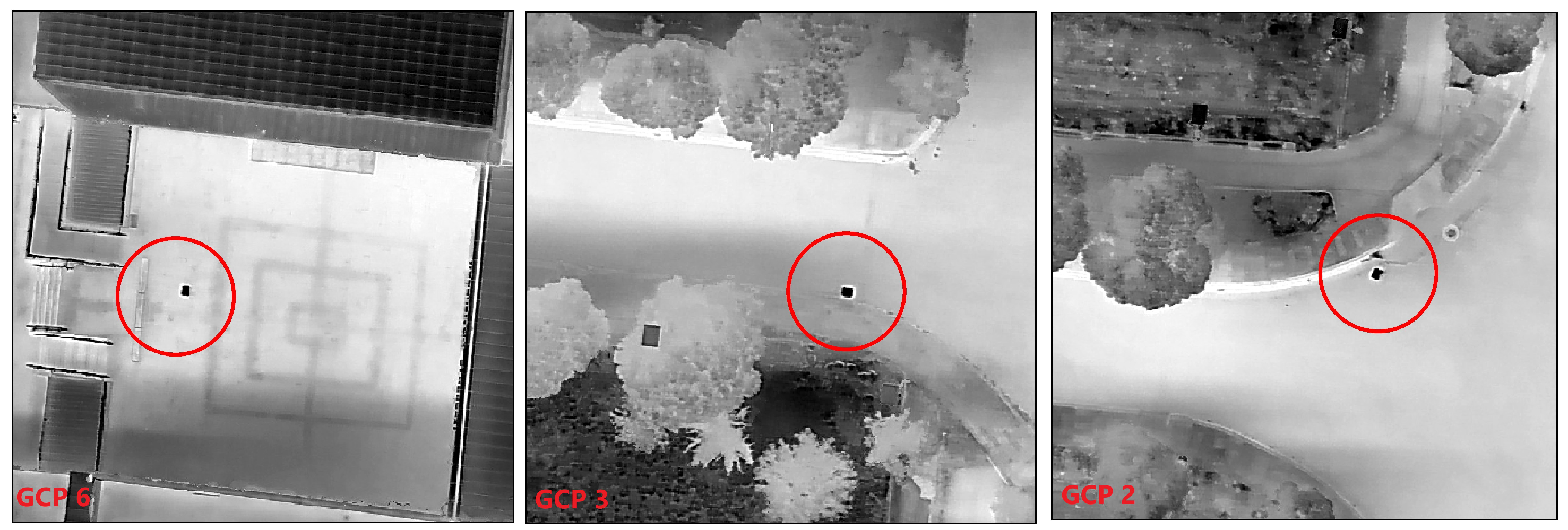
Given the importance of accurate georeferencing in DSM generation, particularly under nocturnal conditions where traditional visual GCPs (ground paintings, movable colored plates, or distinct natural permanent objects) are less visible or not visible at all, the use of highly reflective aluminum sheets as GCPs and checkpoints provides convenience in georeferencing. Thus, unlike typical colored markers used in daylight, these aluminum sheets provided high reflectivity in thermal images and enhanced the visibility of GCPs (
Figure 3).
Six GCPs and four checkpoints were strategically placed across the study area, and their positions were precisely measured using GPS to ensure accuracy in the subsequent photogrammetric processing. In total, ten aluminum sheets were utilized—six as GCPs and four as checkpoints. While using additional GCPs might enhance model accuracy, only aluminum plates were employed since other potential reference objects, such as building corners or natural features, lacked sufficient visibility in thermal images captured during nighttime conditions. Given that photogrammetric accuracy depends on the ability to precisely identify identical points across multiple overlapping images, the thermally distinctive and consistently visible aluminum plates were selected to ensure reliable georeferencing and minimize positional errors. The measured coordinates are given in
Table 1. The positions were measured using an RTK-GNSS receiver with real-time correction data provided by the national CORS-TR (Continuously Operating Reference Stations) system. The horizontal and vertical positional accuracy of the measured points was approximately ±2 cm. All geospatial data in this study, including GCP measurements and derived DSMs, were obtained with reference to the Turkish National Reference Frame (TUREF) using the GRS80 ellipsoid and projected with the Transverse Mercator 3° zone (TM-39E) system. This projection minimizes distortion for our study region, with negligible impact on accuracy given the limited spatial extent of the study area (9.4 hectares).
GCPs and checkpoints were distributed to comprehensively cover the work area (
Figure 4). Additionally, checkpoints were selected to achieve a homogeneous spread across the area, ensuring no excessive concentration of points on one side. Then, a thermal flight was carried out at night, according to the photogrammetric flight plan. The thermal image acquisition was completed in a short, uninterrupted flight, reducing the likelihood of temperature fluctuations or internal sensor drift during data collection.
To ensure comprehensive coverage of the study area, the UAV was flown at an altitude of 35 m, with both sidelap and endlap rates increased to 90% for the aerial photographs, using the DJI Mavic 3 Enterprise Thermal (
Figure 5). This high overlap rate is critical for nighttime operations to compensate for the reduced visibility and uniform thermal signatures, ensuring sufficient image data for effective feature matching in the SfM process in Agisoft Metashape. A total of 1746 thermal aerial photographs were obtained during the flight operations, achieving a ground sample resolution of 4.66 cm per pixel.
The photogrammetric analysis yielded a high density of data points distributed across the study area. A sufficiently dense point cloud supports the completeness and surface continuity of the DSM; however, geometric accuracy also depends on the quality of image alignment and ground control. Additionally, a significant number of tie points, totaling 2,562,011, were established, facilitating the precise alignment and integration of individual images into a coherent and reliable model. The process culminated in the creation of a dense point cloud, consisting of 135,110,368 points (
Figure 6).
This extensive point cloud forms the fundamental structure from which the DSM is derived; offering a detailed and robust three-dimensional representation of the surveyed terrain resulted in a point density of 0.117 points per square centimeter. The obtained high point density allows the generation of an accurate and detailed representation of the study area in the DSM (
Figure 7).
4.2. Accuracy Analyses
This section includes RMSE calculations, which quantify the spatial Z accuracy of the produced DSM, and correlation calculations, which assess the similarity of this DSM to the reference DSM in terms of surface characteristics.
4.2.1. Error Metrics
As part of the bundle adjustment process, the average camera location errors were reported to be m in the X direction, m in Y, and m in Z, with an overall XY error of m. The average reprojection error was pixels, indicating an acceptable level of internal consistency for image alignment under thermal imaging conditions and sparse ground control.
To determine the RMSE of the elevation values, the checkpoints were compared with the corresponding elevations derived from the T-DSM (
Table 2).
Based on the calculations according to Equation (
1), the RMSE is 5.22 cm. This value indicates a very high level of accuracy between the GPS-measured elevations and those captured by the T-DSM, suggesting that the T-DSM is quite precise and closely aligns with the ground-truth data.
To provide a more detailed understanding of the model’s accuracy, the individual elevation differences at each checkpoint, along with the computed error metrics, are presented in
Table 3, which reveals that the elevation differences (ΔZ) between the thermal DSM and the GPS-measured checkpoints are consistently small and negative, indicating a slight systematic underestimation of elevation values in the thermal model.
The mean error of m reflects this systematic bias, while the low standard deviation of m suggests that the discrepancies are highly uniform across all checkpoints. The RMSE value of m further corroborates the overall accuracy of the model under nighttime thermal imaging conditions. Although only four checkpoints were used in this preliminary experiment, the low variability among them indicates that the thermal DSM produced highly consistent results.
4.2.2. Correlation
As mentioned in the previous section, a Ref-DSM was used for correlation analysis. This Ref-DSM was generated from data collected during a daytime UAV flight conducted with a classic RGB camera drone. The UAV was flown at an altitude of 35 m to ensure wide coverage while capturing detailed aerial photographs with an 80% overlap rate, optimizing the conditions for effective photogrammetric processing. These images were subsequently processed using SfM techniques to produce the Ref-DSM. Statistics of individual DSMs are given in
Table 4.
The minimum and mean values for both the Ref-DSM and T-DSM are close, with the maximum values being particularly similar. This similarity indicates that both datasets capture a comparable range of elevation values, suggesting they have consistent detection capabilities for the highest and lowest points in the area. Given the presence of reflective objects such as solar panels, water, and metal surfaces in the study area, it is likely that noise data caused by these objects may have slightly influenced the minimum values in DSM production. The mean values of both DSMs are very close, suggesting that on average, both DSMs record similar central values of the elevation data across the surveyed area. The standard deviations are also similar, indicating that the spread of elevation values around the mean is almost the same, thus providing consistency in data variability and reliability between the two DSMs. The calculated covariance matrix is given in
Table 5.
The covariance values between the Ref-DSM and T-DSM are closely aligned with the individual variances of each dataset. This high covariance suggests that the elevations recorded by the reference and T-DSMs vary together substantially, indicating a significant similarity in the distribution of elevation values across both DSMs. The calculated correlationmatrix is given in
Table 6.
The correlation coefficient of 0.975 between the Ref-DSM and T-DSM indicates a very strong positive linear relationship between the datasets. Essentially, as elevation values in one DSM increase or decrease, the corresponding values in the other DSM also increase or decrease in a similar manner. This high correlation confirms that the T-DSM reliably mirrors the Ref-DSM in terms of how terrain features are spatially correlated, validating the T-DSM’s accuracy and utility in reflecting true terrain characteristics as well as the Ref-DSM.
It is important to note that the RGB-derived DSM serves as a reference for correlation analysis to assess the spatial consistency and pattern similarity between thermal and conventional photogrammetric products, rather than as a primary validation dataset. The absolute accuracy validation of the T-DSM is primarily based on direct comparison with GPS-measured ground control points and checkpoints, as presented in the RMSE analysis. This approach ensures that the geometric accuracy assessment is grounded in ground-truth measurements rather than potentially introducing systematic errors from the reference DSM processing workflow.
5. Discussion
The findings of this study provide clear answers to the research questions posed. Addressing RQ1, the study confirms that DSMs can be effectively produced using aerial photographs captured at night by UAVs equipped with thermal cameras. The application of the SfM approach in processing these images has proven successful, demonstrating the feasibility of this technique under nocturnal conditions.
Regarding Q2, the precision of the elevation information in the DSMs is commendable. The RMSE for the Z coordinate is low at 5.22 cm, highlighting the accuracy of the T-DSM when compared to the Ref-DSM. This level of precision underscores the effectiveness of integrating aerial thermal imagery with ground control points, and it confirms the reliability of the T-DSM in capturing true ground elevations. Despite challenges posed by reflective and heat-retaining materials, the minimal variance observed between the minimum and maximum values of the DSMs underscores the robustness of thermal imaging across varied environmental settings. In addition, the high density of data points and the large number of tie points enhance the accuracy of the DSMs, allowing the details of the topography to be accurately captured and to remain consistent across different segments of the study area.
In response to RQ3, the correlation coefficient of 0.975 between the Ref-DSM and T-DSM reveals a very high degree of linear relationship. This indicates that the T-DSM is capable of accurately replicating the Ref-DSM’s elevation data. Such a strong correlation not only confirms the utility of thermal imagery in capturing detailed terrain information under nighttime conditions but also highlights its potential to integrate seamlessly with traditional elevation data sources, thereby enhancing terrain analysis.
Exploring the potential of nighttime-UAV-based thermal imaging to generate DSMs, this study reveals unique challenges and opportunities across different environmental contexts. Urban environments, with their complex mix of material thermal properties and prevalent light pollution, offer substantial application potential, particularly for energy efficiency assessments. Conversely, non-urban areas, characterized by minimal infrastructural and light interference, are ideal for environmental monitoring and agricultural uses, despite challenges in establishing ground control and data consistency.
Important lessons from this study include the critical role of technical aspects of UAV operations, particularly the quality of thermal sensors, in refining DSM accuracy. Effective flight planning and careful management of flight parameters such as speed and altitude are critical to optimizing data quality as more detail is typically obtained at lower altitudes and slower speeds. Operational challenges, including logistical and safety concerns associated with night operations, require increased attention to personnel safety and navigation. Regulatory and financial hurdles, such as obtaining night flight permits and managing the costs associated with advanced thermal imaging equipment and software, are significant barriers.
Environmental conditions, including extreme weather, seasonal variations, and challenges over water bodies, significantly affect UAV performance and imaging quality, often restricting deployment in geographically and regulatory constrained areas. These findings underscore the need for comprehensive planning and adaptive strategies to overcome these challenges and fully exploit the capabilities of nighttime-UAV-based thermal imaging for DSM generation.
Despite the promising results, it is important to acknowledge certain limitations inherent to thermal imaging. These include the relatively low spatial resolution of thermal cameras compared to RGB sensors, potential geometric distortions due to lens characteristics, and challenges related to radiometric calibration under varying environmental conditions. Addressing these limitations through sensor improvements and advanced correction algorithms will be essential for expanding the reliability of nighttime thermal DSM generation in future applications.
Although this study does not establish a direct relationship between surface temperature and elevation accuracy, it is important to note that thermal homogeneity across materials may cause distinct features to become visually indistinguishable in thermal images. Under such conditions, image matching becomes challenging or unfeasible, adversely affecting the structure-from-motion process. Further research should investigate how surface temperature contrast influences the detectability of geometric discontinuities and the success rate of feature matching in thermal photogrammetry.
6. Conclusions
This study has successfully demonstrated the viability of using nighttime-UAV-based thermal imaging to generate high-resolution DSMs, marking a unique application in the field of UAV photogrammetry. The integration of nocturnal thermal imagery with UAV photogrammetry has demonstrated its feasibility and effectiveness in producing detailed and accurate representations of terrain. Additionally, the calculated low RMSE and high correlation between the thermal and reference DSMs underscores the effectiveness of the applied approach.
In particular, the thermal DSM achieved an RMSE of 0.0522 m, a mean error of m, and a standard deviation of 0.0054 m based on the elevation residuals from four GPS checkpoints. The spatial distribution of these residuals indicated no significant clustering or directional bias, suggesting a consistent geometric performance across the study area.
The adoption of nighttime thermal DSM generation presents a promising expansion of UAV capabilities, offering significant benefits for environmental monitoring, urban planning, disaster management, and other fields requiring detailed geographical data. This study’s approach promises to be invaluable in emergency situations, such as nighttime disasters where quick, accurate terrain assessment is critical. Expanding the operational capabilities of UAVs to include nighttime operations increases our flexibility to address a variety of environmental and emergency situations and allows us to manage, analyze, and respond to complex geospatial data more effectively. Future research will focus on refining the methods discussed here, exploring broader applications, and addressing the operational challenges identified. Continued innovation in integrating UAV technology with thermal imaging will significantly advance our capacity to accurately model and understand the Earth’s surface dynamics under diverse conditions.
This study represents an initial investigation into the potential of nighttime thermal photogrammetry for accurate terrain modeling. While the results demonstrate promising accuracy levels and validate the core methodology, this work establishes a foundation for addressing the broader challenges inherent in nocturnal geospatial data acquisition. The methodological framework presented here provides a stepping stone toward more robust nocturnal remote sensing applications, contributing to the gradual expansion of UAV-based surveying capabilities into previously inaccessible temporal domains.


