Article

The Detection of Tree of Heaven (Ailanthus altissima) Using Drones and Optical Sensors: Implications for the Management of Invasive Plants and Insects

1
Entomology Program, Division of Plant and Soil Sciences, West Virginia University, Morgantown, WV 26506, USA
2
Northern Research Station, USDA Forest Service, Morgantown, WV 26505, USA
*
Author to whom correspondence should be addressed.
Submission received: 18 October 2023 / Revised: 7 December 2023 / Accepted: 15 December 2023 / Published: 19 December 2023
(This article belongs to the Special Issue Feature Papers for Drones in Agriculture and Forestry Section)

Abstract

:
Tree of heaven (Ailanthus altissima) is a highly invasive tree species in the USA and the preferred host of an invasive insect, the spotted lanternfly (Lycorma delicatula). Currently, pest managers rely solely on ground surveys for detecting both A. altissima and spotted lanternflies. This study aimed to develop efficient tools for A. altissima detection using drones equipped with optical sensors. Aerial surveys were conducted to determine the optimal season, sensor type, and flight altitudes for A. altissima detection. The results revealed that A. altissima can be detected during different seasons and at specific flight heights. Male inflorescences were identifiable using an RGB sensor in the spring at <40 m, seed clusters were identifiable in summer and fall at <25 m using an RGB sensor, and remnant seed clusters were identifiable in the winter at <20 m using RGB and thermal sensors. Combining all seasonal data allowed for the identification of both male and female A. altissima. This study suggests that employing drones with optical sensors can provide a near real-time and efficient method for A. altissima detection. Such a tool has the potential to aid in the development of effective strategies for monitoring spotted lanternflies and managing A. altissima.

1. Introduction

Tree of heaven, Ailanthus altissima (Mill.) Swingle, also known as the Chinese sumac and stink tree, is an invasive tree native to China [1]. It has been widely introduced as an ornamental and street tree in many parts of the world [2]. In the USA, A. altissima was first introduced in Pennsylvania in 1784 [1,3], and its widespread invasion occurred in the late 20th century. As of 2023, A. altissima has been found in more than 40 US states, spreading extensively throughout the Eastern United States [2,4]. The invasion of A. altissima and its successful establishment in the USA can be attributed to its prolific seed production, which begins 4–5 years after germination and can last for over 100 years [3,5].
Ailanthus altissima is a medium-sized dioecious tree, meaning male and female trees are separate, with a height of 12–30 m at maturity [6,7]. It can be easily recognized by its distinctive bark, leaf, and seed cluster characteristics [8]. It has compound leaves with heart-shaped leaflets [9], each of which has one glandular tooth, or many glandular teeth, at the rounded base. Mature female trees produce flat, twisted, winged seeds, bearing up to 30,000 seeds per tree in a year [7,10]. They can vary from greenish yellow to reddish brown and are arranged in clusters, with each cluster containing more than 100 seeds [11]. These characteristics are commonly used for the detection and identification of A. altissima, which is essential for its successful management.
Ailanthus altissima can rapidly colonize both natural and urban habitats [12], and it is widespread in forest edges, fields, and along roadsides. It poses a significant threat to native ecosystems by negatively impacting native vegetation regeneration and growth and reducing native plant species richness [13,14]. Therefore, monitoring and mapping A. altissima are essential for developing effective management strategies for this invasive tree. Currently, A. altissima monitoring activities primarily focus on roadside, trail, and parking lot areas, exploiting the visual identification of its distinctive traits. After detection, A. altissima is managed by combinations of mechanical, cultural, and chemical methods [15].
The presence and abundance of A. altissima have a more significant economic impact due to the invasion of the spotted lanternfly, Lycorma delicatula (Hemiptera: Fulgoridae), which utilizes A. altissima as its main feeding and reproductive host. The spotted lanternfly is an agricultural pest that can also be a nuisance in urban areas in the USA. Since its introduction in 2014 [16], the spotted lanternfly has spread throughout several Mid-Atlantic States, and it is expected to spread nationally [17,18]. It damages crops by both feeding on plant sap and excreting a large amount of honeydew [19], which can cause the generation of sooty mold that interferes with photosynthesis. Of the more than 70 known host plants, the most preferred host plant is A. altissima [20]. A. altissima is found abundantly along transportation corridors in areas with the spotted lanternfly [21]. Therefore, A. altissima can be used as a sentinel plant to monitor the spotted lanternfly [22] for early detection and rapid response to the invasion. Currently, pest managers solely rely on ground surveys to detect A. altissima for spotted lanternfly monitoring [23]. Ground surveys are time-consuming, laborious, and challenging to implement in hazardous and hard-to-access areas.
Modern technologies have been employed in analyzing invasive species distribution and applying control measures. Specifically, remote sensing has emerged as a powerful tool for the detection and monitoring of invasive plant species [24,25,26]. Small unmanned aerial vehicles (sUAS, also known as drones) have been shown to be effective tools for aerial surveys of invasive plants, weeds, diseases, and insects [27]. They have been used to detect plant species in terms of various aspects of agriculture and plant protection in various agroecosystems, and they can serve as important tools for the detection of pests [27,28]. While A. altissima has been mapped with the classification of satellite images with spectral signatures [29], high-resolution aerial images are required for individual tree detection [30]. Rebbeck et al. [31] conducted aerial mapping to detect A. altissima using seed-bearing females in winter using a helicopter, but this method could not differentiate male A. altissima trees from other tree species at such a height. Estimates of A. altissima sex ratios are 1:1 [32], indicating half the population would go undetected with this method. In addition, flying helicopters at low altitudes poses risks for both those operating the helicopter [33] and the potential of increasing seed dispersal [34]. Therefore, drones offer advantages over helicopter or satellite imaging due to their flexibility, low cost, and extremely high image resolution [35]; however, rotary-wing drones have limitations in covering large survey areas [34,36]. In addition, it is necessary to determine the optimal season for the detection of A. altissima because no previous studies have investigated the seasonal detection of A. altissima.
The goal of this study was to develop a protocol for the aerial detection of A. altissima which can also be used for its management and for monitoring the spotted lanternfly. The objectives of this study were to determine the optimal (1) optical sensors, (2) seasons for aerial surveying, and (3) flight heights for the detection of A. altissima using drones. The results of this study can help develop an efficient and effective survey tool for detecting A. altissima and the spotted lanternfly, especially in hard-to-access or hazardous areas.

2. Materials and Methods

2.1. Study Sites

This study was conducted in two locations in West Virginia, USA (Figure 1): Morgantown (39.629524 N, 79.955894 W) and Kearneysville (39.393283 N, 77.898887 W). The Kearneysville site is a 0.5 ha flat forested area infested with spotted lanternflies. On this site, A. altissima were found inside and on the edge of the forested area. The Morgantown site is a 0.5 ha steep forested area where the presence of spotted lanternflies has not been reported. A. altissima were found along roadsides on this site.

2.2. Aerial Surveys with Drones

Aerial surveys were carried out in 2022 and 2023 to determine the optimal optical sensors and season(s) for detecting A. altissima. Specifically, aerial surveys were conducted in spring, summer, fall, and winter, when A. altissima is leafing out and flowering (spring), fruiting (summer and fall), and senescing (winter). Evaluating all four seasons allowed us to focus on different plant parts, including leaves, inflorescences with leaves, seed clusters with leaves, and remnant seed clusters without leaves (Figure 2).

2.2.1. Drones and Optical Sensors

We used three different drones that carried three different optical sensors: the DJI Mavic 2 Enterprise Advanced, carrying RGB and thermal sensors (SZ DJI Technology Co., Ltd., Shenzhen, China); the DJI Mavic 2 Pro, carrying an RGB sensor; and the Phantom 3 Advanced, carrying a normalized difference vegetation index (NDVI) sensor (Sentera, St. Paul, MN, USA). The RGB sensors took natural color images; the thermal sensor created images with heat signatures, and NDVI values were calculated from red and near-infrared wavelengths. All drone flights with all the sensors in this study were conducted between noon and 3 p.m. on sunny days with a wind speed of <10 kph (see Tables S1 and S2 for specifications of drones and detailed flight information).

2.2.2. Aerial Survey of A. altissima in Spring

A series of aerial surveys were carried out to detect the leaves and inflorescences of A. altissima in spring (May–June). A total of 20 individual male A. altissima were selected randomly to determine the optimal flight height above the tree canopy. Drones equipped with RGB, thermal, and NDVI sensors were flown at 18 different flight heights ranging from 5 m to 90 m with 5 m increments to determine the optimal flight height. After the aerial surveys were completed, the aerial images were downloaded from the drones and analyzed.

2.2.3. Aerial Survey of A. altissima in Summer and Fall

Ailanthus altissima seed clusters slowly change their colors from green or white at the beginning of summer, transitioning to a yellow or red color in late summer before finally shifting to grayish brown at the end of the fall season. The same aerial survey methods described in Section 2.2.2 were used to detect leaves (Figure 2a) and seed clusters (also known as samaras of A. altissima) in June–October.

2.2.4. Aerial Survey of A. altissima in Winter

Ailanthus altissima begins to lose its leaves in early-mid fall, with most having fallen by winter. However, many seed clusters still remain on the branches throughout the winter. The same aerial surveys described in Section 2.2.2 were used to detect seed clusters on the A. altissima in November–April. Thermal images were taken during the month of February on cold sunny days, usually after snowfall was observed because seed clusters retain cold temperatures for a longer time. A total of 50 images including seed clusters and branches were taken. In addition, a separate aerial survey was conducted to acquire aerial images every two hours from 9:30 to 17:30, because winter temperatures can change dramatically within a day. The temperatures of 15 different seed clusters and branches on each A. altissima tree were measured using a DJI Mavic 2 Enterprise Advanced drone carrying both RGB and thermal sensors.

2.3. Data Analysis

Each aerial image was visually examined to determine the detectability of A. altissima leaves, inflorescences, and seed clusters. The optimal flight height above the canopy was determined by assessing the relationship between the detectability of A. altissima and flight altitudes.
The detectability was recorded as detectable (value = 1) at each flight altitude when our visual inspection of the aerial image could confirm the taxonomical and morphological features and signatures of A. altissima, including leaf size and shape, seed cluster size and shape, flower color and texture, and tree shape and size. When we were unable to identify the features, detectability was recorded as undetectable (value = 0). Pix4DMapper (Pix4D, Prilly, Switzerland) was used to generate NDVI values, and DJI Thermal Analysis Tool 3 (DJI, Shenzhen, China) was used to analyze the thermal images.
Non-linear regression was used to fit the data using JMP (JMP, Version Pro 17.2.0, SAS Institute Inc., Cary, NC, USA). Flight heights above the tree canopy were used as the independent variable, and the detectability at each altitude was recorded as a nominal variable. The logistic regression fitted the best with the detectability data (i.e., the estimated probability of detecting the features of A. altissima at different flight altitudes). Chi-square values and r2 values were used to evaluate the performance of the regression model for each sensor in each season.

3. Results

Overall, we found that different optical sensors could be used to detect A. altissima in different seasons. RGB sensors could be used to detect A. altissima in all seasons, and thermal sensors only achieved successful detection in winter. However, we found that the NDVI sensor was not able to detect A. altissima in any season (Figure 3).

3.1. Detection of A. altissima in Spring

The leaves of A. altissima were detectable using drones with an RGB sensor from early March. The inflorescences of A. altissima were detectable for a short period in May. Male A. altissima have larger inflorescences than those on female trees and were detectable when using an RGB sensor (Figure 4). Due to their smaller size, female inflorescences can only be seen at very low flight altitudes (i.e., <10 m above the canopy). The relationship between flight height and detectability fitted best with logistic regression (χ2 = 392.4; d.f. = 1; r2 = 0.79; p < 0.0001). The results of our regression analysis showed that A. altissima male inflorescences were detectable up to 60 m above the tree canopy and that the probability of detecting the male inflorescences was 100% at <35 m above the tree canopy (Figure 4). The thermal and NDVI sensors did not detect A. altissima leaves in spring.
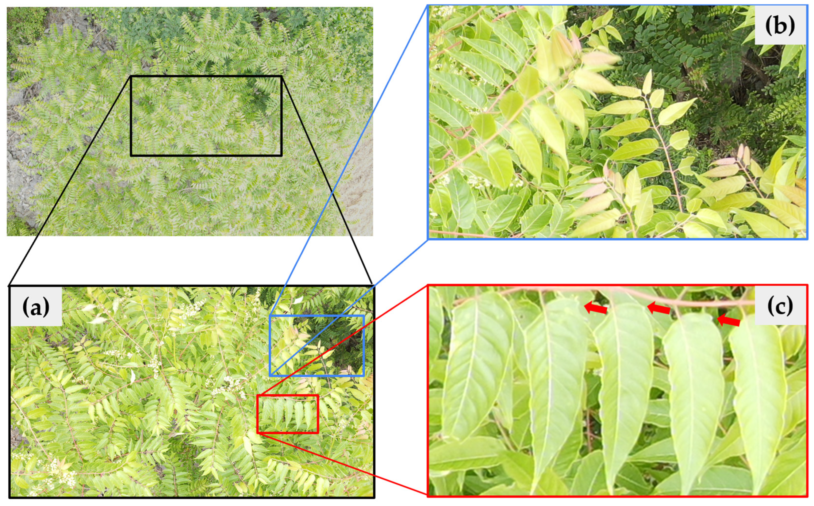
From the RGB images, pink leaves at the tip of the A. altissima branches were noticeable and detectable from early spring (Figure 5a,b). A. altissima leaves could be detected at <10 m above the canopy of the trees. A key distinguishing feature of A. altissima leaves, their tooth structure, which acts like an extended structure, at the base of the leaf (Figure 5c), could be seen in the RGB images. A sympodial–modular pattern (resulting in branches appearing to radiate in a spiral fashion from above) in the A. altissima branches was observed from the aerial images (Figure 5a). Such features enabled us to detect A. altissima from 35 m to 50 m above the tree canopy, and the sympodial–modular branch pattern was readily identifiable at <35 m above the tree canopy.

3.2. Detection of A. altissima in Summer and Fall

Seed clusters of A. altissima in female trees were detectable with the use of RGB images (Figure 6). The relationship between flight height and detectability fitted best with logistic regression (χ2 = 378.5; d.f. = 1; r2 = 0.79; p < 0.0001). The probability of detecting the seed clusters was 100% at <25 m above the tree canopy (Figure 6). Male trees also could be detected in early summer and fall based on the radiating branching pattern at 35 m above the canopy.

3.3. Detection of A. altissima in Winter

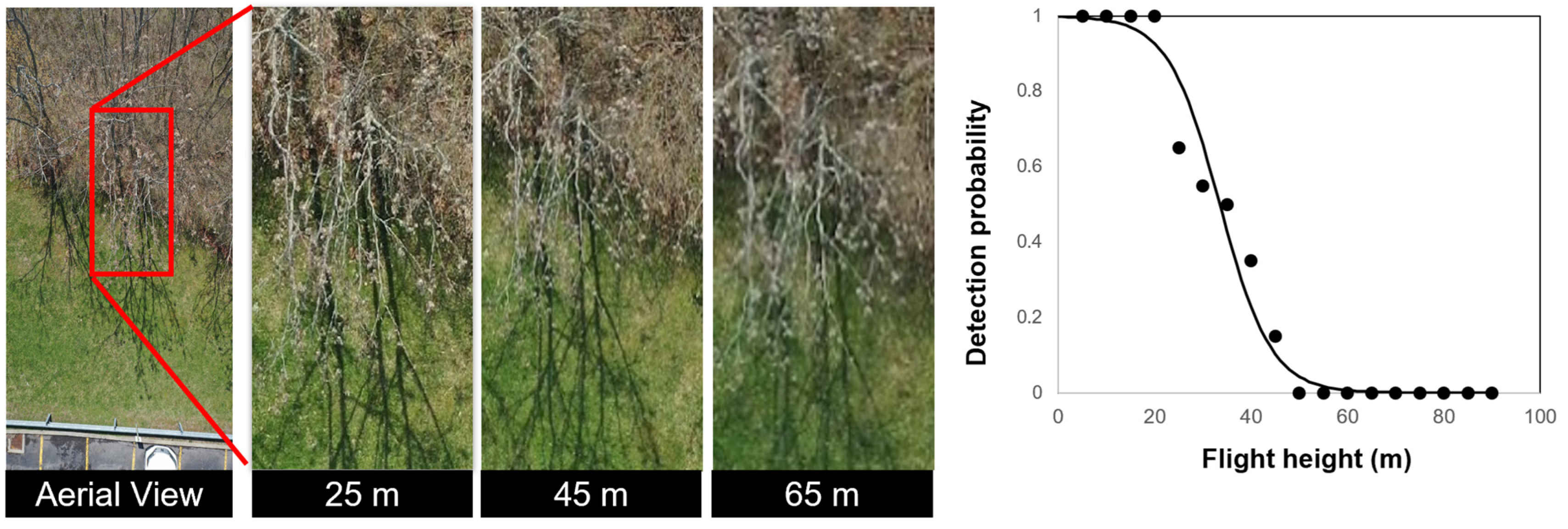
Seed clusters of A. altissima were detectable in winter using RGB and thermal sensors at flight heights of <20 m above the tree canopy (Figure 7). The relationship between flight height and detectability fit best with logistic regression (χ2 = 324.6; d.f. = 1; r2 = 0.70; p < 0.0001).
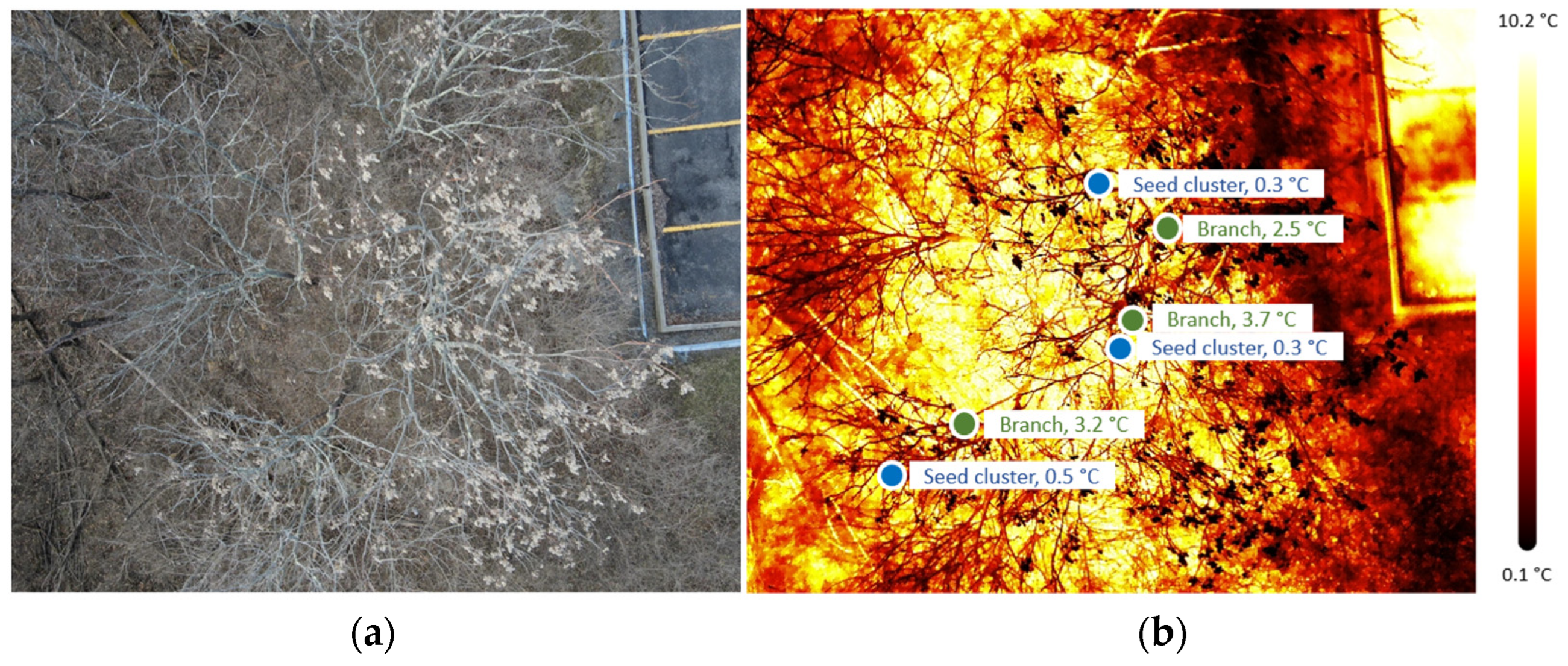
The thermal sensors detected the heat signatures of A. altissima seed clusters on cold sunny days. The temperature of the seed clusters was significantly lower than that of the branches (Figure 8); the average temperature of the seed clusters was 0.37 ± 0.32 °C, with a range of 0–1.0 °C, and that of branches was 3.06 ± 0.45 °C, with a range of 2.1–4.2 °C. The average difference in temperature between the seed clusters and branches was 2.68 ± 0.58 °C, with a range of 1.1–3.6 °C.
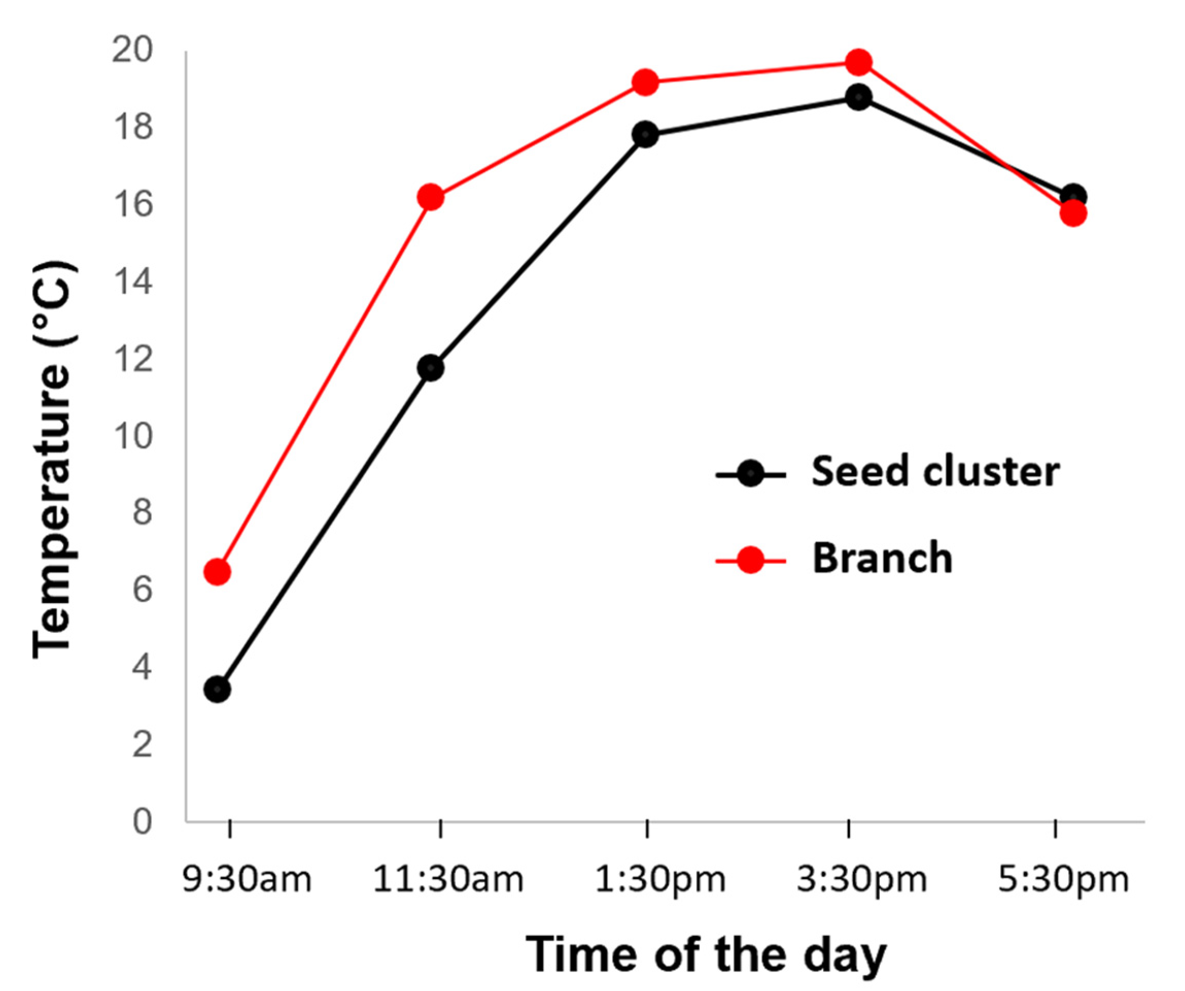
The temperature of the seed clusters and their associated branches changed throughout the day (Figure 9). The temperature of the seed clusters and branches increased throughout the day until 15:30 and decreased afterward. The temperature of the seed clusters was significantly lower than that of the branches, with the largest difference of 4.41 ± 1.20 °C occurring at 11:30 a.m. The temperature of the seed clusters exceeded that of the branches after 5:00 p.m., although the difference was minimal.

4. Discussion

The results of this study showed that various life stages of A. altissima can be detected from aerial images obtained using a drone equipped with multiple optical sensors (see Table 1). During the spring season, A. altissima can be located by detecting male inflorescences (<40 m above the canopy), sympodial–modular branching patterns (<35 m above the canopy), and leaves (<10 m above the canopy). In the summer, seed clusters (e.g., female trees) become distinct when observed from a height of <25 m above the canopy, and in the winter, this distinction occurs at <20 m above the tree canopy when using an RGB sensor. Additionally, on cold, sunny winter days, the thermal sensor can detect heat signatures, with a temperature difference of 3 °C between seed clusters and their associated branches being measured in this study.
Mapping and conducting regular management operations for A. altissima are crucial to mitigate its threat [37]. Also, determining the optimal time for aerial surveys using drones to detect an invasive plant is essential for successful management [38]. Male A. altissima trees can be identified by their inflorescences in late spring, while female trees are best identified by their seed clusters in the summer, fall, and winter. To comprehensively detect both male and female A. altissima, we recommend conducting flights in spring, as well as summer, fall, or winter. Utilizing multi-seasonal data has proven to be more effective for identifying and mapping A. altissima [30]. Alternatively, conducting a single-season flight, such as identifying the sympodial–modular branching in spring or using low-altitude flights to confirm the female in spring or summer, is also possible. However, only female trees with seed clusters can be identified during the winter season. Non-flowering/fruiting, younger trees are likely best detected using the sympodial–modular branching in the spring.
During the fall season, there may be confusion with the fruits of other trees, such as ash, when A. altissima seed clusters turn brown. To mitigate this, consider conducting flights during the summer, when the seed clusters exhibit a yellowish or reddish color. It is worth noting that the detectability of seed clusters during winter is lower due to the potential for them to drop because of harsh weather conditions, which are influenced by factors such as wind speed, direction, and environmental conditions [39]. Complex backgrounds can pose challenges for image analysis [40], leading to confusion with background disturbances like brown bushes and seed clusters that resemble branches at higher flight altitudes when only a few seed clusters are left on the tree. The use of a thermal sensor can improve detection accuracy in winter, as we found temperature differences between branches and seed clusters. Seed clusters absorbed and released heat slowly compared to the branches that were darker in color and absorbed almost all of the light. Notably, the temperature of seed clusters fluctuates throughout the day, with the most significant difference occurring around noon, which is also the recommended time for general drone flights.
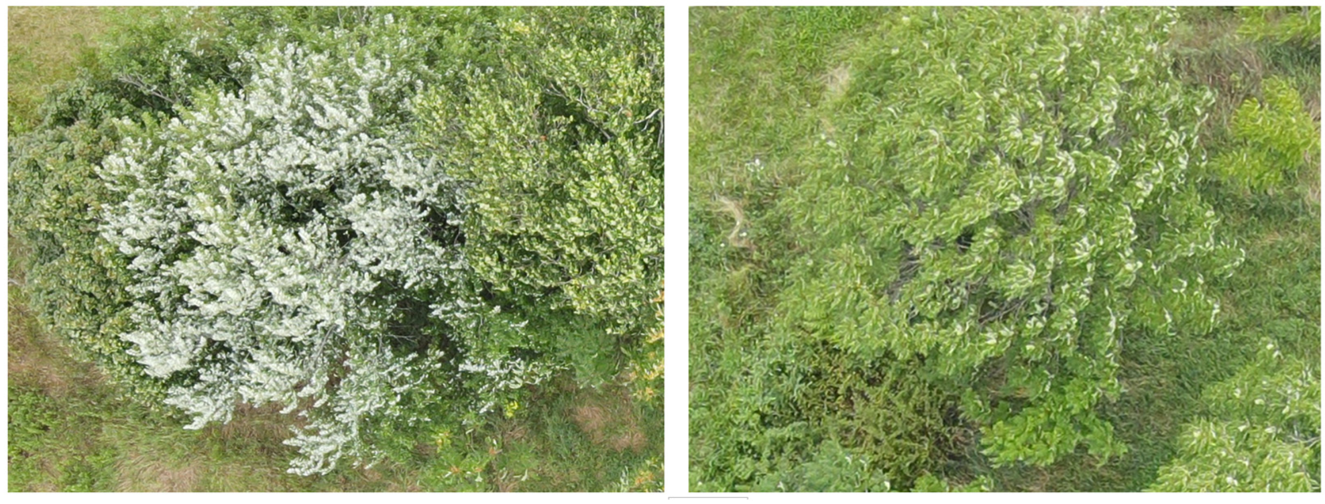
The thermal sensor we used in this study was unable to detect heat signatures on cold days when there was still residual snow in the background. The temperature of both the background and the seed clusters appeared similar, with no temperature distinction being observed. The NDVI sensor was not able to detect A. altissima in any season of the year, but it holds potential for evaluating the effectiveness of A. altissima control [41]; after successful control, causing the death of A. altissima, it should be detectable via the use of the NDVI sensor, as there should be no healthy vegetation remaining. Drones can be flown when wind speed is below 27 kph, following the regulations of the Federal Aviation Administration (FAA) of the USA [42]. However, in high winds, leaves can be turned upside down, which can lead to confusion with flowers or fruits (see Figure 10).
Small A. altissima saplings can remain hidden under the canopies of larger trees and may not be visible in an aerial survey. However, small A. altissima saplings growing on the forest edges can still be detected. We observed the sympodial–modular branching pattern of A. altissima at <35 m above the tree canopy along forest edges. However, this pattern resembles that of native trees such as staghorn sumac (Rhus typhina) and black walnut (Juglans nigra), which are often found together in forests [43]. There should be no confusion with sumac when the trees are tall, as A. altissima can grow up to 25 m, while staghorn sumac typically ranges from 1 to 10 m in height [44]. In addition, the seed clusters of these two trees differ from each other; the color change in the leaves of staghorn sumac occurs slightly earlier than the color change in A. altissima. Furthermore, there is a distinction in the leaf texture between black walnut and A. altissima, as black walnut leaves have a lighter green color and bend more towards the ground from the branch, whereas A. altissima leaves are parallel to the branch (Figure 11). Our study revealed that flying a drone at <10 m above the canopy allows for the detection of the tooth structure at the petiole end of A. altissima leaves. This feature makes it easier to differentiate A. altissima from other visually similar native trees.
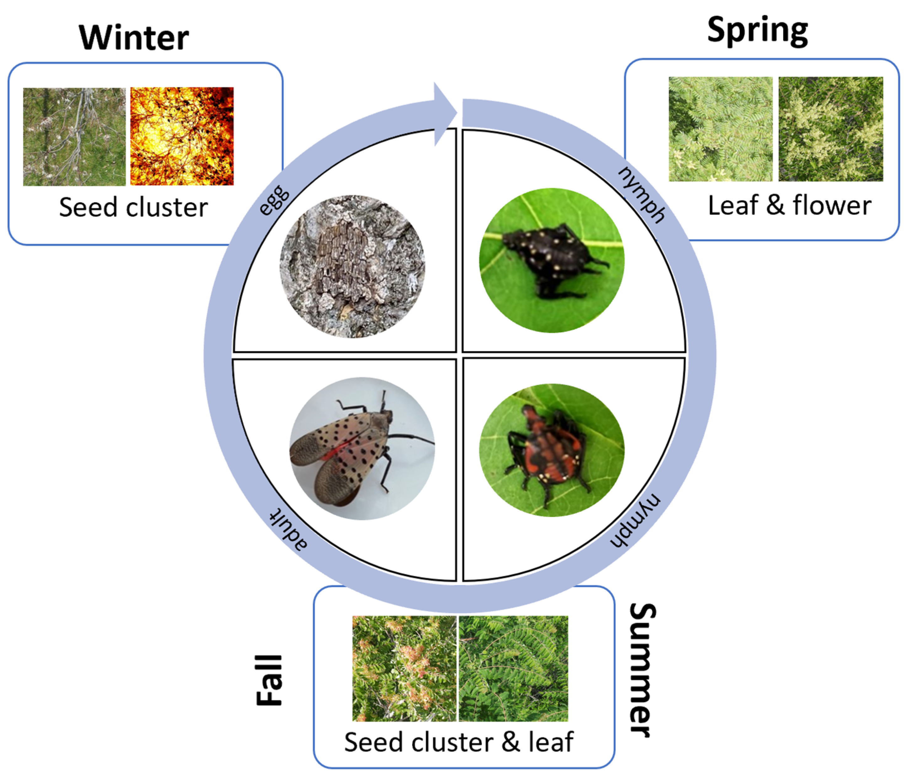
The removal of A. altissima is recommended for the management of spotted lanternflies in specialty crops [45]. Identifying A. altissima can significantly aid in the real-time monitoring of spotted lanternflies using drones (Figure 12). Spotted lanternflies lay eggs from October to December, which hatch into nymphs (first instar in May–June, second and third instars in June–July, and fourth instar in July–September) and turn into adults from July to December for mating and egg laying [46]. In winter, both RGB and thermal sensors can be used together to enhance the detection of A. altissima. The different life stages of spotted lanternflies can be monitored and managed based on the various life stages of A. altissima (Figure 12). Eggs can be monitored in the winter season, nymphs in the spring and early summer, and adults during the summer and fall seasons [47], with the identification of A. altissima being possible during all of those seasons.
Although our study shows that flying drones < 10 m above the tree canopy can facilitate the complete (100%) detection of A. altissima, there are potential limitations regarding drone flight and operation at such low flight altitudes. However, recent advances in drones equipped with anti-collision sensor technology and software for autonomous drone flight that can follow changing terrains and tree canopies make low-altitude aerial surveys possible. In addition, the analysis of drone images using machine learning techniques has gained popularity amid these technological advancements [48]. The development of machine learning capabilities for the automated detection of A. altissima based on aerial images would be helpful for the management of the species. Currently, mobile applications for identifying tree species based on ground images are available. These applications were built by using machine learning [49]; thus, we tested whether commercially available mobile applications could detect A. altissima based on the aerial images that we obtained in this study. We found that the applications’ abilities to accurately identify A. altissima based on aerial images were very poor. Therefore, future studies may develop a tool for the automated detection of A. altissima using deep learning algorithms with aerial images to make aerial surveys and invasive pest detection more efficient and precise [50,51].
The results of this study carry three important management implications. Firstly, using drones to detect A. altissima can be more effective than the currently adopted ground-based survey methods, which rely on visual detection from roads and involve mapping known infestations or helicopters [15], which are limited in their detection capabilities, only detecting mature female trees. Drones are particularly valuable for detecting A. altissima within dense forests that are difficult to access. Additionally, drone detection can be used to map A. altissima, creating a detailed infestation map to better understand its extent and distribution and aiding in the development of precision management strategies. Secondly, utilizing different optical sensors can help locate A. altissima during various life stages. Detecting A. altissima during different seasons contributes to the development of effective strategies and management options. Lastly, identifying A. altissima aids in identifying the different life stages of the spotted lanternfly at different times of the year for the real-time monitoring of this invasive pest, enabling the early detection of this species and a more rapid response to better prevent its spread into new regions.

Supplementary Materials

The following supporting information can be downloaded at: https://www.mdpi.com/article/10.3390/drones8010001/s1, Table S1: The specifications of the drones and sensors used in the study; Table S2: Detailed drone flight information on sampling dates.

Author Contributions

Conceptualization, Y.-L.P.; methodology, Y.-L.P., C.D.H. and K.N.; software, Y.-L.P. and K.N.; validation, Y.-L.P., C.D.H. and K.N.; formal analysis, Y.-L.P. and K.N.; investigation, Y.-L.P. and K.N.; resources, Y.-L.P. and K.N.; data curation, Y.-L.P. and K.N.; writing—original draft preparation, K.N.; writing—review and editing, Y.-L.P. and C.D.H.; visualization, Y.-L.P. and K.N.; supervision, Y.-L.P. and C.D.H.; project administration, Y.-L.P.; funding acquisition, Y.-L.P. All authors have read and agreed to the published version of the manuscript.

Funding

The research described in this paper was supported by the USDA NIFA AFRI Foundational and Applied Sciences Grant Program (2021-67014-33757) and the West Virginia Specialty Block Grant (21SCBPWV1032-00).

Data Availability Statement

Data will be made available upon request.

Acknowledgments

We would like to thank Jennifer Greenleaf, Roghaiyeh Karimzadeh, Viki Kondo, Tim Winfield, and Sophia Deleon at West Virginia University for their help with field sampling, drone operation, and field management.

Conflicts of Interest

The authors declare no conflict of interest.

References

  1. Hu, S.Y. Ailanthus. Arnoldia 1979, 39, 29–50. [Google Scholar]
  2. Sladonja, B.; Sušek, M.; Guillermic, J. Review on Invasive Tree of Heaven (Ailanthus Altissima (Mill.) Swingle) Conflicting Values: Assessment of Its Ecosystem Services and Potential Biological Threat. Environ. Manage 2015, 56, 1009–1034. [Google Scholar] [CrossRef] [PubMed]
  3. Kasson, T.M.; Davis, M.D.; Davis, D.D. The Invasive Ailanthus Altissima in Pennsylvania: A Case Study Elucidating Species Introduction, Migration, Invasion, and Growth Patterns in the Northeastern US. Northeast. Nat. 2013, 20, 1–60. [Google Scholar] [CrossRef]
  4. EDDMapS. Early Detection & Distribution Mapping System. The University of Georgia—Center for Invasive Species and Ecosystem Health. Available online: http://www.eddmaps.org/ (accessed on 12 September 2023).
  5. Wickert, K.L.; O’Neal, E.S.; Davis, D.D.; Kasson, M.T. Seed Production, Viability, and Reproductive Limits of the Invasive Ailanthus Altissima (Tree-of-Heaven) within Invaded Environments. Forests 2017, 8, 226. [Google Scholar] [CrossRef]
  6. Dirr, M.A. Manual of Woody Landscape Plants, 5th ed.; Stipes Publishing LLC: Champaign, IL, USA, 1998; pp. 92–93. [Google Scholar]
  7. Kowarik, I.; Säumel, I. Biological Flora of Central Europe: Ailanthus Altissima (Mill.) Swingle. Perspect. Plant Ecol. Evol. Syst. 2007, 8, 207–237. [Google Scholar] [CrossRef]
  8. Ulus, A.; Yilmaz, H.; Akkemik, U.; Yılmaz, O.Y. Assessing Street-level Distribution of Tree of Heaven (Ailanthus altissima) in Istanbul (Turkey). Appl. Ecol. Environ. Res. 2021, 19, 2793–2802. [Google Scholar] [CrossRef]
  9. Fotiadis, G.; Kyriazopoulos, A.P.; Fraggakis, I. The Behaviour of Ailanthus Altissima Weed and Its Effects on Natural Ecosystems. J. Environ. Biol. 2011, 32, 801–806. Available online: https://pubmed.ncbi.nlm.nih.gov/22471219/ (accessed on 18 September 2023). [PubMed]
  10. Bory, G.; Clair-Maczulajtys, D. Production, Dissemination and Polymorphism of Seeds in Ailanthus altissima. Revue Génerale de Botanique 1980, 88, 297–311. [Google Scholar]
  11. Fryer, J.L. Ailanthus altissima. In Fire Effects Information System. U.S.; Department of Agriculture, Forest Service, Rocky Mountain Research Station, Fire Sciences Laboratory: Missoula, MT, USA, 2010. Available online: https://www.fs.usda.gov/database/feis/plants/tree/ailalt/all.html (accessed on 18 September 2023).
  12. Knapp, L.B.; Canham, C.D. Invasion of an Old-Growth Forest in New York by Ailanthus Altissima: Sapling Growth and Recruitment in Canopy Gaps. J. Torrey Bot. Soc. 2000, 127, 307. [Google Scholar] [CrossRef]
  13. Pimentel, D.; Zuniga, R.; Morrison, D. Update on the Environmental and Economic Costs Associated with Alien-Invasive Species in the United States. Ecol. Econ. 2005, 52, 273–288. [Google Scholar] [CrossRef]
  14. Brooks, R.K.; Barney, J.N.; Salom, S.M. The Invasive Tree, Ailanthus Altissima, Impacts Understory Nativity, Not Seedbank Nativity. For. Ecol. Manag. 2021, 489, 119025. [Google Scholar] [CrossRef]
  15. Forest Service. Field Guide for Managing Tree-of-heaven in the Southwest. United States Department of Agriculture 2014. Available online: https://www.fs.usda.gov/Internet/FSE_DOCUMENTS/stelprdb5410131.pdf (accessed on 3 September 2023).
  16. Barringer, L.E.; Donovall, L.R.; Spichiger, S.-E.; Lynch, D.; Henry, D. The First New World Record Of Lycorma Delicatula (Insecta: Hemiptera: Fulgoridae). Entomol. News 2015, 125, 20–23. [Google Scholar] [CrossRef]
  17. Cook, R.T.; Ward, S.F.; Liebhold, A.M.; Fei, S. Spatial Dynamics of Spotted Lanternfly, Lycorma Delicatula, Invasion of the Northeastern United States. NeoBiota 2021, 70, 23–42. [Google Scholar] [CrossRef]
  18. Wakie, T.T.; Neven, L.G.; Yee, W.L.; Lu, Z. The Establishment Risk of Lycorma Delicatula (Hemiptera: Fulgoridae) in the United States and Globally. J. Econ. Entomol. 2019, 113, 306–314. [Google Scholar] [CrossRef] [PubMed]
  19. Kim, H.; Kim, S.; Lee, Y.; Lee, H.-S.; Lee, S.-J.; Lee, J.-H. Tracing the Origin of Korean Invasive Populations of the Spotted Lanternfly, Lycorma Delicatula (Hemiptera: Fulgoridae). Insects 2021, 12, 539. [Google Scholar] [CrossRef] [PubMed]
  20. Uyi, O.; Keller, J.A.; Swackhamer, E.; Hoover, K. Performance and Host Association of Spotted Lanternfly (Lycorma Delicatula) among Common Woody Ornamentals. Sci. Rep. 2021, 11, 15774. [Google Scholar] [CrossRef] [PubMed]
  21. Urban, J.M. Perspective: Shedding Light on Spotted Lanternfly Impacts in the USA. Pest. Manag. Sci. 2019, 76, 10–17. [Google Scholar] [CrossRef]
  22. Dara, S.K.; Barringer, L.; Arthurs, S.P. Lycorma Delicatula (Hemiptera: Fulgoridae): A New Invasive Pest in the United States. J. Integr. Pest. Manag. 2015, 6, 20. [Google Scholar] [CrossRef]
  23. Urban, J.M.; Leach, H. Biology and Management of the Spotted Lanternfly, Lycorma Delicatula (Hemiptera: Fulgoridae), in the United States. Annu. Rev. Entomol. 2022, 68, 151–167. [Google Scholar] [CrossRef]
  24. Huang, C.; Asner, G. Applications of Remote Sensing to Alien Invasive Plant Studies. Sensors 2009, 9, 4869–4889. [Google Scholar] [CrossRef]
  25. Park, Y.-L.; Naharki, K.; Karimzadeh, R.; Seo, B.Y.; Lee, G.S. Rapid Assessment of Insect Pest Outbreak Using Drones: A Case Study with Spodoptera exigua (Hübner) (Lepidoptera: Noctuidae) in Soybean Fields. Insects 2023, 14, 555. [Google Scholar] [CrossRef]
  26. Kattenborn, T.; Lopatin, J.; Förster, M.; Braun, A.C.; Fassnacht, F.E. UAV Data as Alternative to Field Sampling to Map Woody Invasive Species Based on Combined Sentinel-1 and Sentinel-2 Data. Remote Sens. Environ. 2019, 227, 61–73. [Google Scholar] [CrossRef]
  27. Park, Y.-L.; Cho, J.; Choi, K.-H.; Kim, H.; Kim, J.; Kim, J.; Lee, D.-H.; Park, C.-G.; Cho, Y. Advances, Limitations, and Future Applications of Aerospace and Geospatial Technologies for Apple IPM. Korean J. Appl. Entomol. 2021, 60, 2287–2545. [Google Scholar] [CrossRef]
  28. Park, Y.-L.; Cho, J.R.; Lee, G.-S.; Seo, B.Y. Detection of Monema Flavescens (Lepidoptera: Limacodidae) Cocoons Using Small Unmanned Aircraft System. J. Econ. Entomol. 2021, 114, 1927–1933. [Google Scholar] [CrossRef] [PubMed]
  29. Tarantino, C.; Casella, F.; Adamo, M.; Lucas, R.; Beierkuhnlein, C.; Blonda, P. Ailanthus Altissima Mapping from Multi-Temporal Very High Resolution Satellite Images. ISPRS J. Photogramm. Remote Sens. 2019, 147, 90–103. [Google Scholar] [CrossRef]
  30. Burkholder, A.; Warner, T.A.; Culp, M.; Landenberger, R. Seasonal Trends in Separability of Leaf Reflectance Spectra for Ailanthus Altissima and Four Other Tree Species. Photogramm. Eng. Remote Sens. 2011, 77, 793–804. [Google Scholar] [CrossRef]
  31. Rebbeck, J.; Kloss, A.; Bowden, M.; Coon, C.; Hutchinson, T.F.; Iverson, L.; Guess, G. Aerial Detection of Seed-Bearing Female Ailanthus Altissima: A Cost-Effective Method to Map an Invasive Tree in Forested Landscapes. For. Sci. 2015, 61, 1068–1078. [Google Scholar] [CrossRef]
  32. Rottenberg, A. A Field Survey of Dioecious Plants in Israel: Sex Ratio in Seven Rare Species. Bot. J. Linn. Soc. 2000, 134, 439–442. [Google Scholar] [CrossRef]
  33. Wiegmann, D.A.; Taneja, N. Analysis of Injuries among Pilots Involved in Fatal General Aviation Airplane. Accidents. Accid. Anal. Prev. 2003, 35, 571–577. [Google Scholar] [CrossRef]
  34. Watts, A.C.; Perry, J.H.; Smith, S.E.; Burgess, M.A.; Wilkinson, B.E.; Szantoi, Z.; Ifju, P.G.; Percival, H.F. Small Unmanned Aircraft Systems for Low-Altitude Aerial Surveys. J. Wild. Manag. 2010, 74, 1614–1619. [Google Scholar] [CrossRef]
  35. Dvořák, P.; Müllerová, J.; Bartaloš, T.; Brůna, J. Unmanned Aerial Vehicles for Alien Plant Species Detection and Monitoring. Int. Arch. Photogramm. Remote Sens. Spatial Inf. Sci. 2015, XL-1/W4, 83–90. [Google Scholar] [CrossRef]
  36. Park, Y.-L.; Krell, R.K.; Carroll, M. Theory, technology, and practice of site-specific insect pest management. J. Asia-Pac. Entomol. 2007, 10, 89–101. [Google Scholar] [CrossRef]
  37. Rebbeck, J.; Jolliff, J. How Long Do Seeds of the Invasive Tree, Ailanthus Altissima Remain Viable? For. Ecol. Manag. 2018, 429, 175–179. [Google Scholar] [CrossRef]
  38. Park, Y.-L.; Gururajan, S.; Thistle, H.; Chandran, R.; Reardon, R. Aerial release of Rhinoncomimus latipes (Coleoptera: Curculionidae) to control Persicaria perfoliata (Polygonaceae) using an unmanned aerial system. Pest. Manag. Sci. 2018, 74, 141–148. [Google Scholar] [CrossRef] [PubMed]
  39. Landenberger, R.E.; Kota, N.L.; McGraw, J.B. Seed Dispersal of the Non-Native Invasive Tree Ailanthus Altissima into Contrasting Environments. Plant Ecol. 2007, 192, 55–70. [Google Scholar] [CrossRef]
  40. Zhang, C.; Xia, K.; Feng, H.; Yang, Y.; Du, X. Tree Species Classification Using Deep Learning and RGB Optical Images Obtained by an Unmanned Aerial Vehicle. J. For. Res. 2020, 32, 1879–1888. [Google Scholar] [CrossRef]
  41. Ewane, E.B.; Mohan, M.; Bajaj, S.; Galgamuwa, G.A.P.; Watt, M.S.; Arachchige, P.P.; Hudak, A.T.; Richardson, G.; Ajithkumar, N.; Srinivasan, S.; et al. Climate-Change-Driven Droughts and Tree Mortality: Assessing the Potential of UAV-Derived Early Warning Metrics. Remote Sens. 2023, 15, 2627. [Google Scholar] [CrossRef]
  42. Federal Aviation Administration. Part 107—Small Unmanned Aircraft Systems. Federal Register. 2016; 81, pp. 42063–42103. Available online: https://www.govinfo.gov/content/pkg/FR-2016-06-28/pdf/2016-15079.pdf (accessed on 5 October 2023).
  43. Call, L.J.; Nilsen, E.T. Analysis of Spatial Patterns and Spatial Association between the Invasive Tree-of-Heaven (Ailanthus Altissima) and the Native Black Locust (Robinia Pseudoacacia). Am. Midl. Nat. 2003, 150, 1–14. [Google Scholar] [CrossRef]
  44. Swearingen, J.M.; Pannill, P.D. Factsheet: Tree of Heaven. Plant Conservation Alliance’s Alien Plant Working Group 2009. Available online: https://www.invasive.org/alien/fact/pdf/aial1.pdf (accessed on 2 September 2023).
  45. Laveaga, E.; Hoover, K.; Acevedo, F.E. Life History Traits of Spotted Lanternfly (Hemiptera: Fulgoridae) When Feeding on Grapevines and Tree of Heaven. Front. Insect Sci. 2023, 3, 1091332. [Google Scholar] [CrossRef]
  46. Keller, J.A.; Johnson, A.E.; Uyi, O.; Wurzbacher, S.; Long, D.; Hoover, K. Dispersal of Lycorma Delicatula (Hemiptera: Fulgoridae) Nymphs through Contiguous, Deciduous Forest. Environ. Entomol. 2020, 49, 1012–1018. [Google Scholar] [CrossRef]
  47. Leach, A.; Leach, H. Characterizing the Spatial Distributions of Spotted Lanternfly (Hemiptera: Fulgoridae) in Pennsylvania Vineyards. Sci. Rep. 2020, 10, 20588. [Google Scholar] [CrossRef]
  48. Oliveira, R.A.; Näsi, R.; Niemeläinen, O.; Nyholm, L.; Alhonoja, K.; Kaivosoja, J.; Jauhiainen, L.; Viljanen, N.; Nezami, S.; Markelin, L.; et al. Machine Learning Estimators for the Quantity and Quality of Grass Swards Used for Silage Production Using Drone-Based Imaging Spectrometry and Photogrammetry. Remote Sens. Environ. 2020, 246, 111830. [Google Scholar] [CrossRef]
  49. Baker, P.; CNN Underscored. Best Plant Identification Apps for Mobile in 2023, Tested by Our Editors. CNN Underscored. Available online: https://www.cnn.com/cnn-underscored/reviews/best-plant-identification-app (accessed on 12 September 2023).
  50. Valicharla, S.K.; Li, X.; Greenleaf, J.; Turcotte, R.M.; Hayes, C.J.; Park, Y.-L. Precision Detection and Assessment of Ash Death and Decline Caused by the Emerald Ash Borer Using Drones and Deep Learning. Plants 2023, 12, 798–798. [Google Scholar] [CrossRef]
  51. Fromm, M.; Schubert, M.; Castilla, G.; Linke, J.; McDermid, G. Automated Detection of Conifer Seedlings in Drone Imagery Using Convolutional Neural Networks. Remote Sens. 2019, 11, 2585. [Google Scholar] [CrossRef]
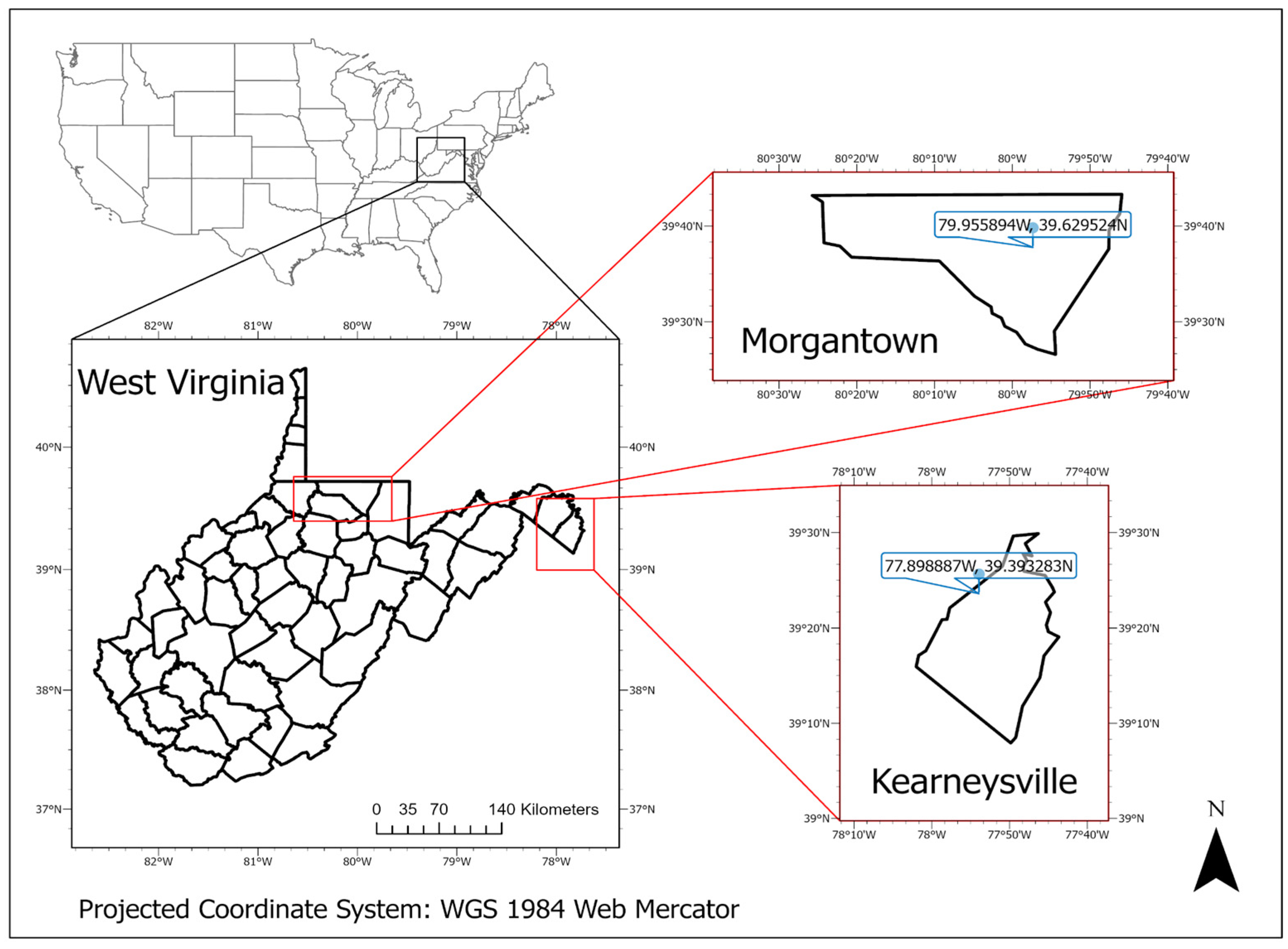
Figure 1. The locations of the two research sites: Morgantown and Kearneysville, West Virginia, USA.
Drones 08 00001 g001
Figure 2. Key morphological features and signatures of A. altissima that can be targeted for aerial detection using drones and optical sensors: leaves (a), inflorescences (b), and seed clusters in summer (c) and winter (d).
Drones 08 00001 g002
Figure 3. Example aerial images acquired using drones and optical sensors: RGB (a), thermal (b), and NDVI (c) sensors. NDVI values were calculated with the values of red and near-infrared wavelengths; a greener color indicates healthier vegetation, and a redder color indicates unhealthy vegetation or non-vegetation.
Drones 08 00001 g003
Figure 4. Aerial image (RGB) of A. altissima at different flight altitudes above the canopy and the relationship between the drone’s flight height above the tree canopy and the probability of detecting A. altissima in spring.
Drones 08 00001 g004
Figure 5. Aerial image (RGB) of A. altissima at 10 m above the tree canopy in early spring: sympodial–modular pattern of branches (a), identifiable red tips of leaves (b), and teeth at the base of A. altissima leaves (c, red arrows).
Drones 08 00001 g005
Figure 6. Aerial image (RGB) of A. altissima fruits at different flight altitudes above the canopy and a graph showing the relationship between the drone’s flight height above the tree canopy (in m) and the probability of detecting A. altissima in the summer and fall seasons.
Drones 08 00001 g006
Figure 7. Aerial image (RGB) of A. altissima at different flight altitudes above the canopy and a graph showing the relationship between the drone’s flight height above the tree canopy (in m) and the probability of detecting A. altissima in the winter season.
Drones 08 00001 g007
Figure 8. Example aerial image (RGB) (a) and thermal images (b) showing an A. altissima canopy in winter. The temperature of the branches was higher than that of the seed clusters.
Drones 08 00001 g008
Figure 9. Temperatures of seed clusters and branches at different times of the day. Temperature data were obtained using a drone equipped with a thermal sensor.
Drones 08 00001 g009
Figure 10. High wind speed causes leaves to turn upside down, mimicking flowers and hindering the identification of A. altissima leaves.
Drones 08 00001 g010
Figure 11. Differences in leaf pattern and texture of A. altissima (a) and black walnut (b).
Drones 08 00001 g011
Figure 12. Drones and optical sensors can be used to detect A. altissima depending on the season. The detection of A. altissima will help detect the different life stages of spotted lanternflies.
Drones 08 00001 g012
Table 1. Detectability of A. altissima in different seasons using various optical sensors.
SeasonSensors
RGBThermalNDVI
Spring
 LeafDetectableUndetectableUndetectable
 InflorescencesDetectableUndetectableUndetectable
 Branching patternDetectableUndetectableUndetectable
Summer and Fall
 LeafDetectableUndetectableUndetectable
 Seed clustersDetectableUndetectableUndetectable
 Branching patternDetectableUndetectableUndetectable
Winter
 Seed clustersDetectableDetectableUndetectable
Disclaimer/Publisher’s Note: The statements, opinions and data contained in all publications are solely those of the individual author(s) and contributor(s) and not of MDPI and/or the editor(s). MDPI and/or the editor(s) disclaim responsibility for any injury to people or property resulting from any ideas, methods, instructions or products referred to in the content.