Communication

Identifying Important Bird and Biodiversity Areas in Antarctica Using RPAS Surveys—A Case Study of Cape Melville, King George Island, Antarctica

by
Katarzyna Fudala
and
Robert Józef Bialik
*
Institute of Biochemistry and Biophysics, Polish Academy of Sciences, Pawińskiego 5A, 02-106 Warsaw, Poland
*
Author to whom correspondence should be addressed.
Drones 2023, 7(8), 538; https://doi.org/10.3390/drones7080538
Submission received: 14 July 2023 / Revised: 11 August 2023 / Accepted: 17 August 2023 / Published: 20 August 2023

Abstract

:
A remotely piloted aircraft system (RPAS) survey of an area containing the eastern extremity of King George Island, including Cape Melville and an extensive part of Destruction Bay, as well as small offshore islands, was undertaken in December 2022. Using RPAS, an inventory of the Destruction Bay area was performed. Chinstrap penguin and Antarctic shag nests were found on Cape Melville and on Trowbridge Island, Middle Island, and an unnamed area located between the Ørnen Rocks formation and Trowbridge Island. During the survey, 507 Antarctic shag nests and over 9000 chinstrap penguin nests were mapped in the investigated area; 458 Antarctic shag nests and 4960 ± 19 chinstrap penguin nests aggregated together on an 8.61 ha land section of Cape Melville were identified. The quantity of Antarctic shag nests found allows for the classification of the area of Cape Melville as an IBA. Among the 175 currently known colonies of Antarctic shags in Antarctica, this is the fifth largest. In this paper, we present the results of the survey, including orthophotos with mapped nest locations. We propose the following recommendations to policy makers and the scientific community: (1) the area of Cape Melville should be classified as an Antarctic Important Bird and Biodiversity Area; (2) based on the RPAS flight, a new boundary of the Cape Melville IBA is proposed; (3) the threshold value (based on >1% of species) to establish an IBA for Antarctic shags should be changed to 122 to reflect the increased estimate of the global population of Antarctic shags; and (4) an inventory of all areas, including previous IBAs that can be qualified as “major colonies of breeding native birds”, should be recommended at the Antarctic Treaty Consultative Meeting (ATCM). In logistically inaccessible bird breeding sites, such as the one presented here, RPASs should be used to carry out regular monitoring of Antarctic Important Bird and Biodiversity Areas.

1. Introduction

Scientific claims of the existence of a colony of chinstrap penguins on Cape Melville, King George Island, date back to 1937 (Roberts (unpublished data), cited by Croxall and Kirkwood [1]). Richard Sherratt was captain of the ship, Lady Trowbridge, which, according to available sources, wrecked on Christmas Day, 1820, in the area of the bay and named the area surrounding the Melville Peninsula to the north “Destruction Bay” because of that event. In his notes published in the Imperial Magazine in 1821, he mentioned that innumerable penguins were present in the waters of South Shetland [2]: “The first intimation you have of being near South Shetland is meeting with a great quantity of whales, of the black kind, and what are called the fin-black, you may thence conclude you are about 150 miles from land. Standing on to the southwards, you will meet with innumerable penguins, so many that you would almost conclude that the sea was animated”. Aside from isolated details of the description of the topography of the Melville Peninsula, no data on the fauna of Cape Melville were provided. The aerial image taken in December 1965 by the Falkland Islands and Dependencies Aerial Survey Expedition (FIDASE), made available on the USGS Earth Explorer platform as a component of the Antarctic Single Frame Records collection in a joint initiative of the British Antarctic Survey (BAS) and the United States Antarctic Resource Center (USARC) (i.e., photo number X26FID0039127), clearly shows bird breeding groups in the Cape Melville area, delineated by bright patches of guano on the rocky ground. The first estimated figures of the abundance of birds found there date back to 1966 (White (unpublished data), cited by Croxall and Kirkwood [1]). According to White, on 27 January 1966 at Cape Melville, 3250 chinstrap penguin nests were accumulated in an area of 2512 m2. The same observer also reported the existence of 1100 nests of chinstrap penguins on Ørnen Rocks. According to Jablonski [3], in 1980, the Cape Melville area was occupied by 9970 pairs of chinstrap penguins. In addition, there was a total of 6308 chinstrap penguin nests on Trowbridge Island, which is approximately 4 km away from Cape Melville, and the author’s notes indicated adjacent unnamed islands were included in the Trowbridge Island formation. Jablonski [3], verifying the claims of Croxall and Kirkwood [1], noted that chinstrap penguins do not nest on the steep rocks of Ørnen Rocks, as Kirkwood reported, so it is more likely that he observed Antarctic shags. In 1987, the Antarctic Marine Living Resources Program provided data on the number, size, and location of penguins and blue-eyed shag colonies and the breeding status of other seabirds in South Shetland Islands [4]. According to the data, 8000 to 9000 (rough estimate) adult chinstrap penguins and 200 to 300 (potential breeder) Antarctic shags were found in Cape Melville on 30 January 1987, while approximately 2000 (rough estimate) adult chinstrap penguins were present on Trowbridge Island on the same day. The authors mentioned that they did not perform a census of the offshore islands on the north coast of KGI from Cape Melville to False Round Point.
According to Harris et al. [5], the Cape Melville area was classified as IBA Ant 063 based on criterion A4iii: “The site is known or thought to hold, on a regular basis, at least 20,000 waterbirds, or at least 10,000 pairs of seabirds, of one or more species”. This was based on a publication by Woehler [6], according to which the Cape Melville area held 16,278 breeding pairs of chinstrap penguins. However, Woehler [6] referred to a publication by Jabłoński [3] that reported the number of penguins in the Cape Melville area and deduced that the Cape Melville area (9970 pairs) also included the Trowbridge Island colony (6308 pairs), which did not fall within the boundaries of the area designated as ex IBA 063. In 2015, in a publication that determined the status of Antarctic IBAs [7] by taking all of the abovementioned considerations into account, IBA 063 Cape Melville was declassified due to the inaccuracies and the lack of updated data for the area.
The eastern and northern parts of King George Island are areas not routinely monitored due to remoteness and difficult accessibility, even though there are ten research stations belonging to nine different countries on the island. The purpose of our field survey was to take an inventory of the Cape Melville area and most of the offshore and inshore areas of Destruction Bay using remotely piloted aircraft systems (RPASs). To our knowledge, the survey we performed to update bird abundance represents the first in the area of Destruction Bay since that of Shuford and Spear [4] which was conducted in 1987.
Before we proceed to the next section, it should be noted that in 2020 BirdLife International [8] revised and updated the nomenclature for the criteria used to identify IBAs. For example, criteria A4i and A4iii no longer exist, but these are related to Global IBA Criterion A4: “The site is known or thought to hold congregations of ≥1% of the global population of one or more species on a regular or predictable basis” and Regional IBA Criterion B3b: “The site is known or thought to hold, on a regular basis, at least 20,000 waterbirds or at least 6700 pairs of seabirds of one or more species”, respectively.

2. Materials and Methods

According to BirdLife International [9], there are 205 terrestrial IBAs and 74 marine IBAs in the Antarctic, of which 12 and 4 are located on or adjacent to King George Island (Figure 1), respectively. Nine of the currently existing terrestrial IBAs were classified based on demographic data that were collected 35 or more years ago, while four were declassified in 2015 due to a lack of data (Figure 1) [7].
An area of approximately 38 km2 containing Cape Melville of the King George Islands and offshore islands from Destruction Bay was surveyed (Figure 2). Inspections of the area were launched from the Arctowski Station, located approximately 50 km from Cape Melville, and were carried out using two offshore pontoon boats (Zodiac model MilPro SeaRib SRA-750 and Zodiac MilPro MK6). The boats were equipped with radar, and depth measurements were taken to allow safe manoeuvring in the area where numerous skerries were present. A record of the GPS route from the boat used for shore landings is plotted on the map presented in Figure 2. Except when the observers disembarked, both boats followed the same track. Checks to confirm species recognition were made both from the boat level, using optical equipment in places where landing was not possible, as well as from the land level by ground-based observers in places where landing the boat was feasible. Designed control photogrammetric missions using RPAS were carried out using two drone models:
  • DJI Phantom 4 Pro V 2.0 with 20 Mpix camera (DJI, Shenzhen, Guangdong, China), hereafter referred to as Phantom;
  • DJI Inspire 2 drone quadcopter with a Zenmuse X5S 20.8 MP camera (DJI MFT 15 mm/1.7 ASPH lens with a 30-mm-equivalent focal length; DJI, Shenzhen, Guangdong, China), hereafter referred to as Inspire.
Both were operated by a pilot who was qualified to fly drones weighing up to 25 kg, for a distance of up to 2 km. All activities were approved by the Polish Antarctic Programme and performed under permit no. 13/2022 for the period from January 2022 to March 2024.
The recommendations presented in Environmental Guidelines for operation of Remotely Piloted Aircraft Systems (RPAS) in Antarctica (v 1.1) [10] and the latest publications on best practices in operating RPASs in Antarctica by Harris et al. [11] were considered when carrying out the RPAS flights.
Visitation of the Cape Melville area was performed three times: the first visit, which allowed confirmation of the presence of colonies on Cape Melville by ground observers, was made on 16 January 2022 (breeding season 2021/2022). In the next breeding season (2022/2023), inspections of Cape Melville were performed using the RPASs on 4 December 2022 and 12 December 2022, which covered the same nest areas. Inspection of the islands from the Destruction Bay area was performed with the Phantom on 12 December 2022. The flight path of each mission was designed using DJI Ground Station Pro (DJI, Shenzhen, Guangdong, China). Flight altitudes and other details of all missions are listed in Table 1. All potential breeding sites in the inspection area marked in Figure 2 were investigated using RPAS, but surveys with pre-planned waypoints were designed and executed only over islands where nests were found after the initial flight. For the Ørnen rocks, a group of islets and sea rocks that was listed in the literature data as a nesting site for chinstrap penguins [1] and a potential nesting site for Antarctic shag [3], the pre-planned waypoint missions were also conducted even though preliminary flights did not confirm the presence of nests. The initial flights were performed in real time using Phantom. The altitude of the survey was set to be at least 40 m above the potential nests and other wildlife.

3. Results

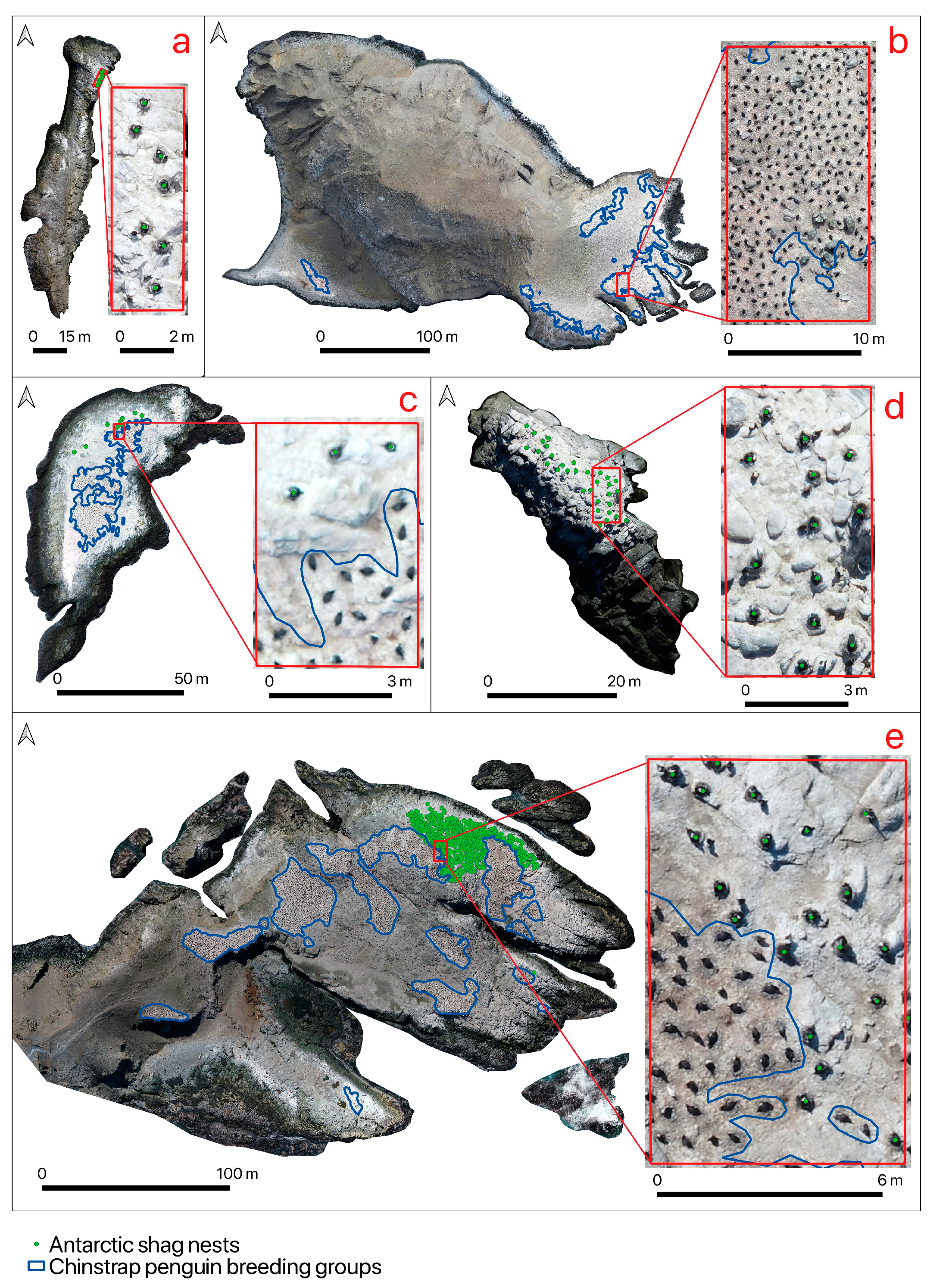
The resolution of the obtained orthophotos ranged from 1.20 cm/px to 5.01 cm/px. First, a mission from 200 m covering all of Trowbridge Island was carried out, followed by another mission from a lower altitude covering the main penguin breeding locations on Trowbridge Island together with the island’s surroundings, including small islets and sea rocks (Table 1). In Trowbridge Island surroundings, we found small, unnamed islets, which we call Trowbridge Annex, where nests of shags (AS) were present. Orthophotos of all islands where shags or penguins were identified are shown in Figure 3. They were created in Pix4Dmapper (Pix4D S.A., Prilly, Switzerland) and analysed using Q-GIS software. AS and CHPE nests were counted independently by three people in the form of point vector layers, and the results are presented in Table 2. Only active nests were counted, i.e., those that had a distinctive shape [12]; those that were judged by the observer to have been formed during the 2022/2023 breeding season; and those where at least one bird was clearly visible within the nest. It was assumed that each active nest corresponded to a pair of birds.
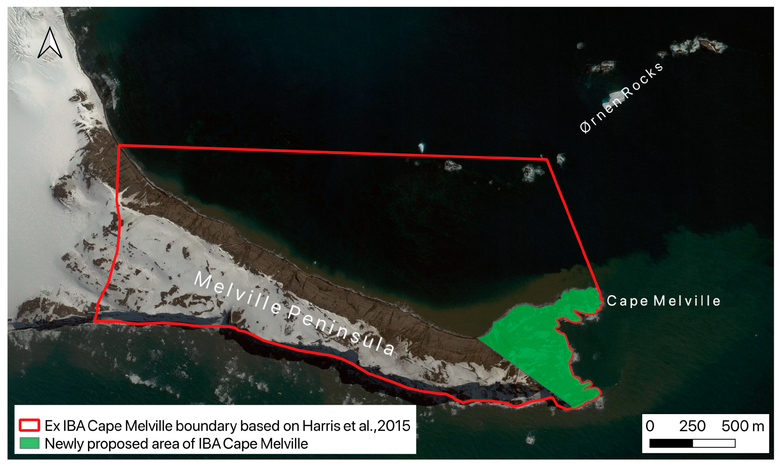
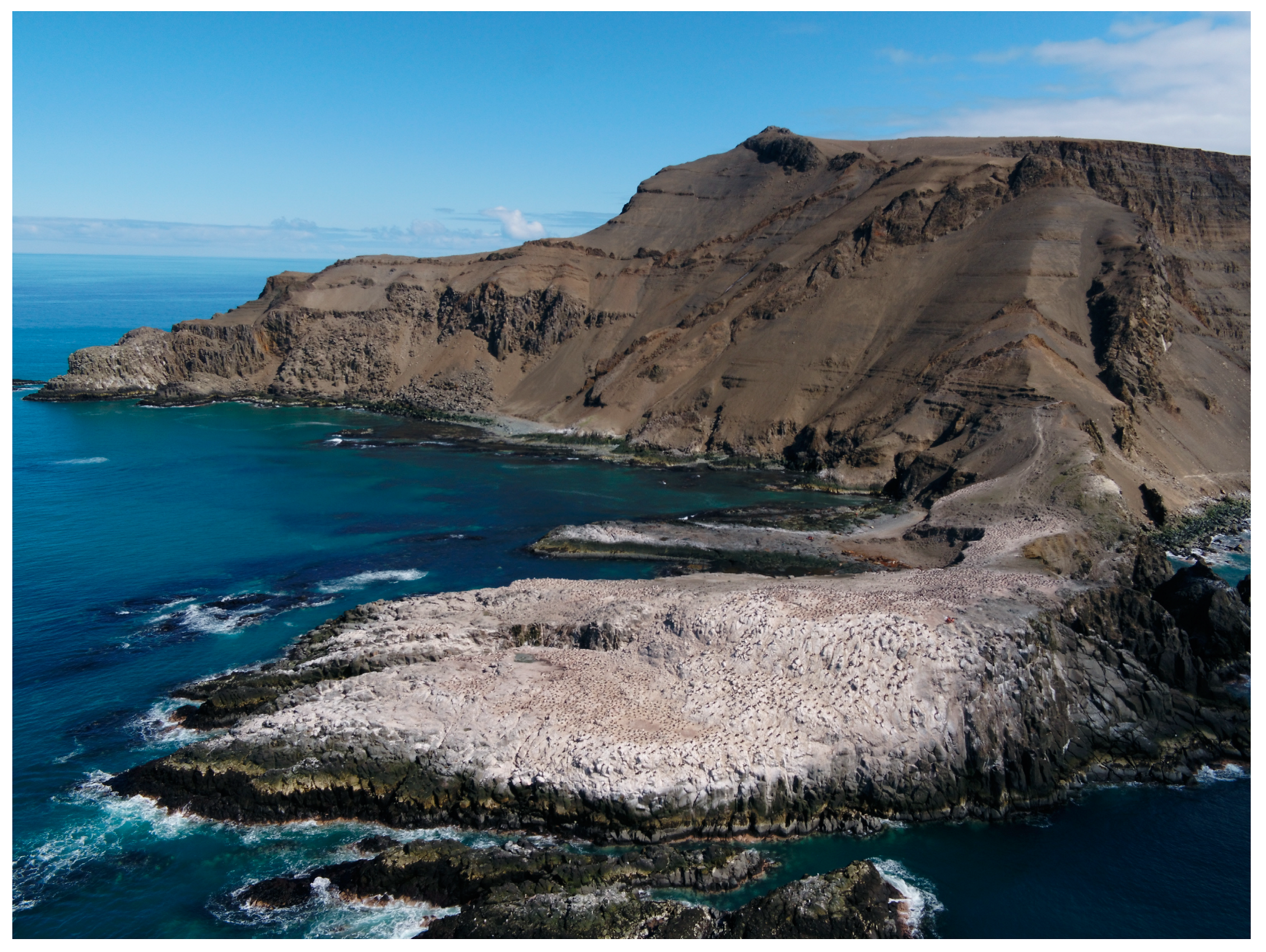
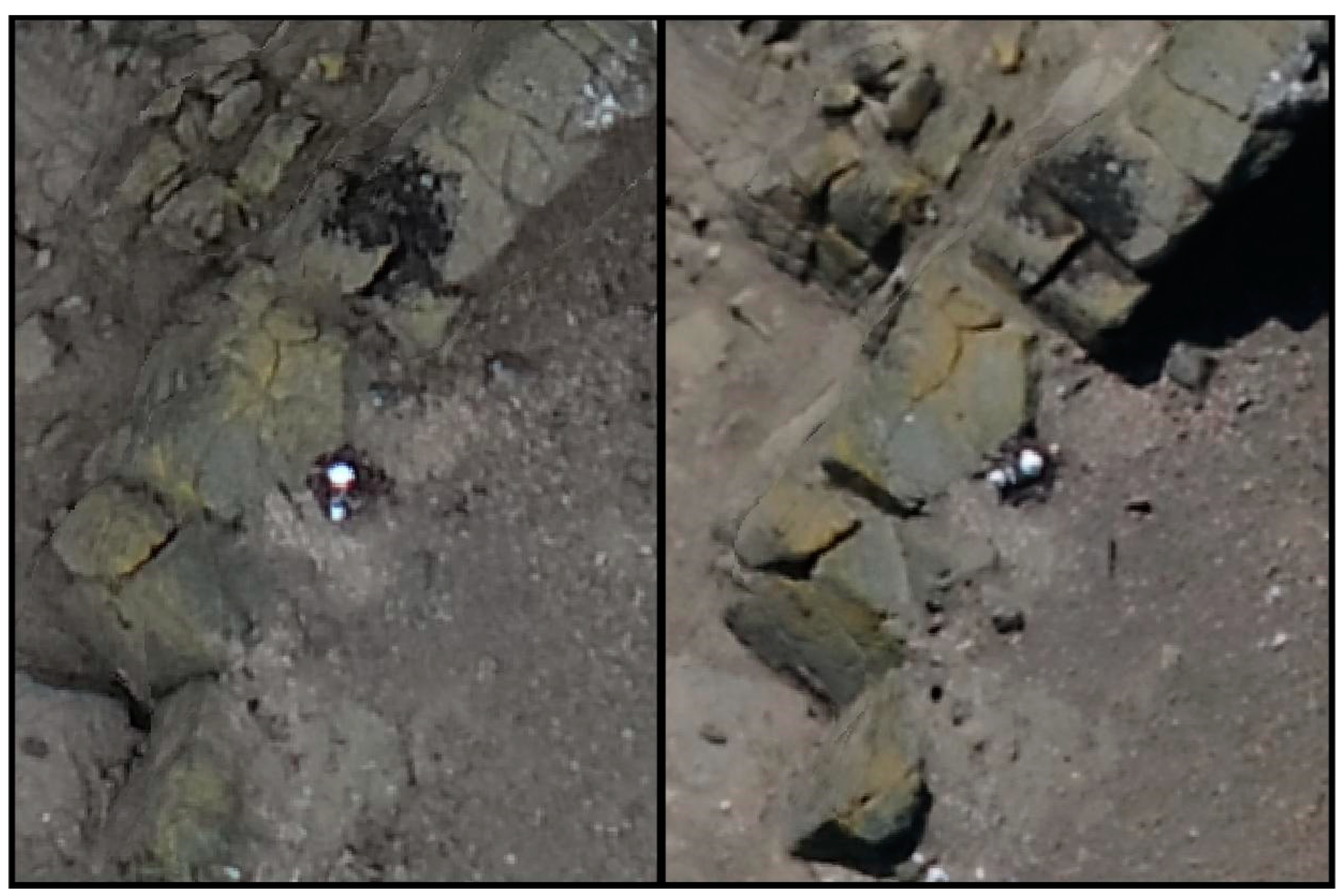
Based on the survey documenting the presence of 458 Antarctic shag nests on Cape Melville, we propose restoring IBA status to Cape Melville, but suggest new boundaries for the area, as presented in Figure 4. The proposed area does not include the entire ice-free area of the Melville Peninsula, and excludes the Cape Melville geological formation, as well as the plateau located at an elevation of more than 120 m (Figure 4 and Figure 5). The proposed region covers an area of 23.2 hectares. The former IBA boundary included an area of 344 hectares and two outlying islands from the Ørnen Rocks formation, where our survey ruled out the potential for penguin or Antarctic shag nests. Shuford and Spear [4] noted that several species were possibly breeding in Cape Melville: cape petrel (Daption capense), Wilson’s storm-petrel (Oceanites oceanicus), snowy sheathbill (Chionis albus), brown and south polar skuas (Stercorarius antarcticus and Stercorarius maccormicki) and kelp gull (Larus dominicanus). Our surveys confirmed at least one kelp gull nest (Figure 6). Moreover, we found more than 50 snowy sheathbill individuals foraging in this area (possible breeders) and at least one pair of brown skua foraging there. The steep slopes and landslides with rock rubble in the area also suggest that the location may be a potential nesting site for Wilson’s and black bellied storm petrels; however, because these are not surface nesting species, their detection on orthophotos is not possible. Importantly, the Melville Peninsula geological formations are extremely valuable sites from a scientific perspective. The Destruction Bay formation provides unique land exposure and a record of late Oligocene warming in West Antarctica [13], which predisposes the entire area of the Melville Peninsula to be placed under special protection in the future.

4. Discussion

Data obtained through surveys conducted in December 2022 confirmed that the Cape Melville site qualifies as an IBA based on criterion A4, which states [8]: “The site is known or thought to hold congregations of ≥1% of the global population of one or more species on a regular or predictable basis”. This was indicated by Harris et al. [5] as the basis for IBA classification with the contribution of the Antarctic shag with the population threshold designated as 133 pairs of this species (threshold determined by Harris et al. [7] based on population size estimates proposed by Wetlands International, Waterbirds Population Estimates, Fourth edition). Schrimpf et al. [14] estimated the global population of this species at 11,366 pairs at 173 active colonies (plus an additional 1984 pairs of uncertain taxonomic status in the South Orkney Islands, which, however, according to a later publication by Rawlence et al. [15], were included in Leucocarbo georgianus). Philips et al. [16] reported one additional/new colony of Antarctic shags, which was found in Ryder Bay, increasing their global population to 11,684 breeding pairs. Since then, drones have been used to assess the abundance of these birds at two known locations at Harmony Point on Nelson Island [17] and along the north-western coast of Nelson Island and the south-western coast of King George Island [12]; the numbers were similar, considering seasonal fluctuations, and not significantly different from those previously reported at these locations by Schrimpf et al. [14]. Our study confirmed that Antarctic shags can be easily identified on aerial images with resolutions of 1.84 cm/px. Using both the estimates adopted by Harris et al. [7] and the most recent available data on the species, the number of Antarctic shag nests we detected increased the global population from 11,684 to 12,191 breeding pairs, allowing the area of Cape Melville to be considered an Important Bird and Biodiversity Area, as the number of nests represents approximately 3.8% of the known global breeding population of the species. Finally, according to Schrimpf et al. [14], the colony of Antarctic shags we found at Cape Melville is the fifth largest and is the 175th known colony in Antarctica.
In 2015, a full list of 204 Antarctic IBAs was acknowledged by the Antarctic Treaty Consultative Meeting (ATCM) 2015 with the adoption of Resolution 5, which recommended that representatives consider the recognised IBAs in the planning and conduct of activities in Antarctica, and emphasised that ongoing research is required to improve knowledge of the status and trends of Antarctic bird populations [18]. Although IBA inventory and monitoring should be evaluated regularly [19,20], the last evaluation of the Antarctic terrestrial IBA network took place in 2015 [18]. Since then, only one area (AQ 205 Ryders Bay) has been added to the IBA list based on the suggestion presented by Philips et al. [16], and, recently, more emphasis has been placed on marine areas [20]. As a result, 74 Antarctic marine IBAs were listed in 2020 [9].
For 2023, the age of the source data on which the terrestrial areas were assessed was as follows: 7.8% from 10 years ago or less, 55.1% from 11 to 20 years ago, 5.4% from 21 to 30 years ago, 20.5% from 31 to 40 years ago, 7.8% from 41 to 50 years ago, and 3.4% from 51 to 60 years ago. The evaluation for some IBAs (particularly those classified under criterion A4iii, species group—seabirds) was based on more than one publication, and the most recent publications among those included in the evaluation were accounted for in this percentage distribution. The trigger species for 24 of 205 IBAs was Leucocarbo bransfieldensis, while Pygoscelis penguins were the trigger species for 49. Based on our experience with the surveys conducted in the Cape Melville area, we recommend the use of RPASs to conduct an inventory of terrestrial IBAs for the presence of penguin and shag nests, as well as other colonial breeders potentially nesting in open spaces that can be identified on aerial images.
There are currently twelve IBAs identified across King George Island, nine of which were classified based on demographic data collected 35 or more years ago. This includes all IBAs (AQ037-044, with trigger species CHPE) located on the northern ridge of King George Island. This is a logistically complex area due to the large number of coastal skerries which make pontoon boat landings difficult or impossible, difficult wind conditions (part of the island is uncovered from the Bransfield Strait), and the long distance (by sea) from the nearest survey stations. RPAS surveys, especially long-range fixed-wing surveys, seem to be an excellent solution for logistically complex locations [21]. RPAS launches can take place from a ship’s landing site or a stretch of coastline accessible to land. As shown in Table 1, the mission time is disproportionate to that required for a ground survey with a ground-based observer, and the process is certainly less invasive to animals than aerial surveys using a helicopter, which, for many Antarctic Specially Protected Areas, whose boundaries coincide with the IBA, such as ASPA 128 (IBA 46) or ASPA 132 (IBA 47), are prohibited.

5. Conclusions

Based on our study we propose the following recommendations to policy makers and the scientific community:
(1)
The area of Cape Melville should be classified as an Antarctic Important Bird and Biodiversity Area;
(2)
Based on the RPAS flight, a new boundary of the Cape Melville IBA is proposed;
(3)
The threshold value (based on >1% of species) for establishing an IBA for Antarctic shags should be changed to 122 because, based on our study, the global population of this species increased to 12,191 breeding pairs;
(4)
An inventory of all areas, including previous IBAs that can be qualified as “major colonies of breeding native birds”, should be recommended at the Antarctic Treaty Consultative Meeting (ATCM).
In logistically inaccessible bird breeding sites, such as the one presented here, RPASs should be used to carrying out regular monitoring of Antarctic Important Bird and Biodiversity Areas.
To assist in further conservation and management planning, the penguin count data obtained within this study will be added to MAPPPD [22].

Author Contributions

Conceptualization, K.F. and R.J.B.; methodology, K.F. and R.J.B.; software, K.F.; validation, K.F.; formal analysis, K.F. and R.J.B.; investigation, K.F. and R.J.B.; resources, K.F.; data curation, K.F.; writing—original draft preparation, K.F. and R.J.B.; writing—review and editing, K.F. and R.J.B.; visualization, K.F.; supervision, R.J.B.; project administration, K.F.; funding acquisition, R.J.B. All authors have read and agreed to the published version of the manuscript.

Funding

This research received funding from the Ministry of Science and Higher Education of Poland, grant no. 6812/IA/SP/2018 and from the Institute of Biochemistry and Biophysics PAS Internal grant MG-09/2021.

Data Availability Statement

The data that support the findings of this study are available on request from the corresponding author.

Acknowledgments

We appreciate the support provided by the Arctowski Polish Antarctic Station. We are particularly grateful to the members of the 45th and 46th Polish Expeditions to King George Island.

Conflicts of Interest

The authors declare no conflict of interest.

References

  1. Croxall, J.P.; Kirkwood, E.D. The Distribution of Penguins on the Antarctic Peninsula and Islands of the Scotia Sea; British Antarctic Survey: Cambridge, UK, 1979; p. 186. [Google Scholar]
  2. Sherratt, R. Observations on South Shetland; Imperial Magazine (London); Columns: London, UK, 1821; pp. 1215–1216. [Google Scholar]
  3. Jabłoński, B. Distribution and numbers of penguins in the region of King George Island (South Shetland Islands) in the breeding season 1980/1981. Pol. Polar Res. 1984, 5, 17–30. [Google Scholar]
  4. Shuford, W.D.; Spear, L.B. Surveys of Breeding Penguins and Other Seabirds in the South Shetland Islands, Antarctica, January–February 1987; NOAA Tech Rep NMFS F/NEC-5; National Oceanic and Atmospheric Administration: Washington, DC, USA, 1988. [Google Scholar]
  5. Harris, C.M.; Carr, R.; Lorenz, K.; Jones, S. Important Bird Areas in Antarctica: Antarctic Peninsula, South Shetland Islands, South Orkney Islands—Final Report; Environmental Research & Assessment Ltd.: Cambridge, UK, 2011; Prepared for BirdLife International and the Polar Regions Unit of the UK Foreign & Commonwealth Office. [Google Scholar]
  6. Woehler, E.J. The Distribution and Abundance of Antarctic and Subantarctic Penguins; Hobart, Scientific Committee on Antarctic Research: Hobart, Australia, 1993. [Google Scholar]
  7. Harris, C.M.; Lorenz, K.; Fishpool, L.D.C.; Lascelles, B.; Cooper, J.; Coria, N.R.; Croxall, J.P.; Emmerson, L.M.; Fijn, R.C.; Fraser, W.L.; et al. Important Bird Areas in Antarctica 2015; BirdLife International and Environmental Research & Assessment Ltd.: Cambridge, UK, 2015. [Google Scholar]
  8. BirdLife International. IBA Criteria. 2023. Available online: http://datazone.birdlife.org/site/ibacriteria (accessed on 11 August 2023).
  9. BirdLife International. Important Bird Area Factsheet: Antarctica Marine 1. 2023. Available online: http://datazone.birdlife.org/site/factsheet/49082 (accessed on 14 July 2023).
  10. ATS. Environmental Guidelines for Operation of Remotely Piloted Aircraft Systems (RPAS) in Antarctica; ATCM Resolution 4; ATCM XLI—CEP XXI; ATS: Bueno Aires, Argentina, 2018. [Google Scholar]
  11. Harris, C.M.; Herata, H.; Hertel, F. Environmental guidelines for operation of Remotely Piloted Aircraft Systems (RPAS): Experience from Antarctica. Biol. Conserv. 2019, 236, 521–531. [Google Scholar] [CrossRef]
  12. Pfeifer, C.A.; Rümmler, M.C.; Mustafa, O. Assessing colonies of Antarctic shags by unmanned aerial vehicle (UAV) at South Shetland Islands, Antarctica. Antarct. Sci. 2021, 33, 133–149. [Google Scholar] [CrossRef]
  13. Warny, S.; Kymes, M.C.; Askin, R.A.; Krajewski, K.P.; Bart, P.J. Remnants of Antarctic vegetation on King George Island during the early Miocene Melville Glaciation. Palynology 2016, 40, 66–82. [Google Scholar] [CrossRef]
  14. Schrimpf, M.; Naveen, R.; Lynch, H.J. Population status of the Antarctic shag Phalacrocorax (atriceps) bransfieldensis. Antarct. Sci. 2018, 30, 151–159. [Google Scholar] [CrossRef]
  15. Rawlence, N.J.; Salis, A.T.; Spencer, H.G.; Waters, J.M.; Scarsbrook, L.; Mitchell, K.J.; Phillips, R.A.; Calderón, L.; Cook, T.R.; Bost, C.-A.; et al. Rapid radiation of Southern Ocean shags in response to receding sea ice. J. Biogeogr. 2022, 49, 942–953. [Google Scholar] [CrossRef]
  16. Phillips, R.A.; Silk, J.R.D.; Massey, A.; Hughes, K.A. Surveys reveal increasing and globally important populations of south polar skuas and Antarctic shags in Ryder Bay (Antarctic Peninsula). Polar Biol. 2019, 42, 423–432. [Google Scholar] [CrossRef]
  17. Oosthuizen, W.C.; Krüger, L.; Jouanneau, W.; Lowther, A.D. Unmanned aerial vehicle (UAV) survey of the Antarctic shag (Leucocarbo bransfieldensis) breeding colony at Harmony Point, Nelson Island, South Shetland Islands. Polar Biol. 2020, 43, 187–191. [Google Scholar] [CrossRef]
  18. ATS. Important Bird Areas (IBAs) in Antarctica. In Proceedings of the ATCM XXXVIII—CEP XVIII, WP040, Sofia, Bulgaria, 1–10 June 2015 . [Google Scholar]
  19. Donald, P.F.; Fishpool, L.D.C.; Ajagbe, A.; Bennun, L.A.; Bunting, G.; Burfield, I.J.; Butchart, S.H.M.; Capellan, S.; Crosby, M.J.; Dias, M.P.; et al. Important Bird and Biodiversity Areas (IBAs): The development and characteristics of a global inventory of key sites for biodiversity. Bird Conserv. Int. 2019, 29, 177–198. [Google Scholar] [CrossRef]
  20. Handley, J.; Rouyer, M.-M.; Pearmain, E.J.; Warwick-Evans, V.; Teschke, K.; Hinke, J.T.; Lynch, H.; Emmerson, L.; Southwell, C.; Griffith, G.; et al. Marine Important Bird and Biodiversity Areas for Penguins in Antarctica, Targets for Conservation Action. Front. Mar. Sci. 2021, 7, 1190. [Google Scholar] [CrossRef]
  21. Zmarz, A.; Rodzewicz, M.; Dąbski, M.; Karsznia, I.; Korczak-Abshire, M.; Chwedorzewska, K.J. Application of UAV BVLOS remote sensing data for multi-faceted analysis of Antarctic ecosystem. Remote Sens. Environ. 2018, 217, 375–388. [Google Scholar] [CrossRef]
  22. MAPPPD. 2023. Available online: www.penguinmap.com (accessed on 11 August 2023).
Figure 1. Localisation of terrestrial and marine IBAs within the vicinity of King George Island.
Drones 07 00538 g001
Figure 2. Inspection area at Destruction Bay with breeding sites of investigated fauna species at: Trowbridge annex (a); Trowbridge Island (b); Middle Island (c); Unnamed Island (d); and Cape Melville (e).
Drones 07 00538 g002
Figure 3. Orthophotos of Trowbridge Annex (a); Trowbridge Island (b); Middle Island (c); Unnamed Island (d); Cape Melville (e).
Drones 07 00538 g003
Figure 4. Boundaries of Ex IBA AQ063 Cape Melville and the newly proposed area of IBA Cape Melville.
Drones 07 00538 g004
Figure 5. Western aerial view of Cape Melville.
Drones 07 00538 g005
Figure 6. Kelp gull nest visible on orthophotos on 4 December 2022 (left) and 12 December 2022 (right).
Drones 07 00538 g006
Table 1. Remotely piloted aircraft systems (RPASs) flight specifications.
Mission DateLocalisationArea Coverage [ha]Flight
Duration
Flight Altitude [m]Ground
Sampling
Distance
(GSD)—Pixel
Resolution [cm]
4 Dec 2022Cape Melville5.367 min 04 s801.84
4 Dec 2022Ørnen Rocks8.064 min 10 s902.51
12 Dec 2022Cape Melville8.6117 min 49 s801.77
12 Dec 2022Unnamed Island0.444 min 41 s451.20
12 Dec 2022Trowbridge Island17.005 min 37 s2005.01
12 Dec 2022Trowbridge Island10.529 min 34 s451.22
12 Dec 2022Middle Island0.836 min 44 s451.22
Table 2. Results of Antarctic shags (AS) and chinstrap penguins (CHPE) nests at different locations within Destruction Bay.
DateLocalisationCHPEAS
Mean ± SD
4 December 2022Cape Melville 4824 ± 12458 ± 0
Ørnen Rocks00
12 December 2022Cape Melville4960 ± 19456 ± 0
Trowbridge Island3435 ± 160
Trowbridge annex07 ± 0
Middle Island627 ± 610 ± 0
Unnamed Island032 ± 0
Disclaimer/Publisher’s Note: The statements, opinions and data contained in all publications are solely those of the individual author(s) and contributor(s) and not of MDPI and/or the editor(s). MDPI and/or the editor(s) disclaim responsibility for any injury to people or property resulting from any ideas, methods, instructions or products referred to in the content.