Review

An Overview of Drone Applications in the Construction Industry

Department of Civil Engineering, Seoul National University of Science and Technology, Seoul 01811, Republic of Korea
*
Author to whom correspondence should be addressed.
Drones 2023, 7(8), 515; https://doi.org/10.3390/drones7080515
Submission received: 4 July 2023 / Revised: 1 August 2023 / Accepted: 2 August 2023 / Published: 3 August 2023
(This article belongs to the Special Issue Intelligent Image Processing and Sensing for Drones)

Abstract

:
The integration of drones in the construction industry has ushered in a new era of efficiency, accuracy, and safety throughout the various phases of construction projects. This paper presents a comprehensive overview of the applications of drones in the construction industry, focusing on their utilization in the design, construction, and maintenance phases. The differences between the three different types of drones are discussed at the beginning of the paper where the overview of the drone applications in construction industry is then described. Overall, the integration of drones in the construction industry has yielded transformative advancements across all phases of construction projects. As technology continues to advance, drones are expected to play an increasingly critical role in shaping the future of the construction industry.

1. Introduction

In recent years, the construction industry has witnessed a remarkable transformation fueled by technological advancements. Among these innovations, drones have emerged as game-changers, redefining the way construction projects are planned, executed, and maintained. Equipped with sophisticated sensors, cameras, and GPS (global positioning system) technology, drones offer unparalleled capabilities to capture real-time data, generate accurate 3D models, and conduct remote inspections. This review paper aims to provide a comprehensive overview of the applications of drones in construction, shedding light on their impact across different project phases and highlighting the potential benefits they bring to the table.
Drones have rapidly evolved from being mere novelties to indispensable tools in the construction sector. By utilizing different types of drones, construction professionals can optimize their workflow, improve project coordination, and mitigate risks [1,2]. Surveying drones, equipped with high-resolution cameras and LiDAR (light detection and ranging) sensors facilitate precise mapping, topographical analysis, and site planning [3,4,5]. These drones capture detailed aerial imagery and generate comprehensive 3D models, enabling architects and engineers to make informed decisions about building placement, design optimization, and resource utilization [6,7].
Inspection drones, on the other hand, provide an unprecedented advantage in assessing hard-to-reach or hazardous areas of construction sites. Equipped with thermal cameras, high-resolution imaging systems, and even artificial intelligence, these drones enable efficient and accurate inspections of infrastructure, buildings, and equipment [8,9,10]. By swiftly identifying structural defects, monitoring construction quality, and ensuring compliance with safety regulations, inspection drones contribute to enhanced project transparency, reduced manual labor requirements, and improved overall project outcomes.
Beyond the core phases of design and construction, drones continue to revolutionize the maintenance stage. Regular inspections using drones enable proactive maintenance planning, identifying potential issues early on, and preventing costly repairs. By conducting detailed assessments of buildings, bridges, and infrastructure, drones contribute to the longevity and resilience of constructed assets. Additionally, the integration of drones in the maintenance phase allows for the swift identification and resolution of defects, leading to improved safety, and reduced downtime [8,11].
The utilization of drones in the construction industry represents a transformative leap towards achieving higher levels of efficiency, safety, and sustainability. By harnessing their data acquisition, monitoring, and inspection capabilities, construction professionals can make informed decisions, improve project outcomes, and optimize resource utilization. As drone technology continues to evolve, it is expected to play an increasingly pivotal role in reshaping the construction industry, fostering innovation, and driving the adoption of smart, resilient construction practices.
In this study, drone technology is reviewed by dividing the actual construction process into three different phases. The architecture of the paper is organized as follows. Section 2 describes the three different types of drones used in the construction industry with the advantages and disadvantages of using each of the drone types. Section 3 discusses the drones used at the designing phase, Section 4 reviews how drones are used at the construction phase and Section 5 overviews the maintenance phase, summarizing how drones are applied to ensure effective maintenance. Then, the study concludes with sections including challenges and opportunities and future directions.

2. Drone Types for Application in Construction Industry

There are various type of drones used in the construction industry for various purposes. In reference [6], the study conducted surveys from many construction companies to find out how drones were used for their construction projects and it showed that the most popular use of drones was in capturing progress photos, followed by taking promotional videos, conducting inspections, and enhancing site management (Figure 1).
As shown in Figure 2, fixed-wing drones, rotary-wing drones, and hybrid drones are three types of drones or unmanned aerial vehicles (UAVs) that are commonly used for various applications, including in the construction and maintenance industries. Each type of drone has its unique advantages and disadvantages, and choosing the right drone for a specific application depends on several factors, such as the size of the area to be covered, the required payload capacity, and the environmental conditions in which the drone will be operated (Table 1). Fixed-wing drones are ideal for covering large areas quickly [12], while rotary-wing drones are more suitable for close-range inspections and operations in confined spaces [13,14,15]. Hybrid drones offer a more versatile and adaptable solution, but may be more complex and expensive than fixed-wing or rotary-wing drones [16]. Ultimately, the right drone for a specific application should be chosen based on a careful analysis of the requirements of the task at hand.

2.1. Fixed-Wing Drones

Fixed-wing drones offer several advantages for civil engineering applications but also come with a few disadvantages. They have longer flight times compared to rotary-wing drones. Their efficient forward flight allows them to cover larger areas and remain airborne for an extended period, which is beneficial for large-scale surveying and mapping projects. These drones can cover larger distances in a single flight due to their higher speed and endurance. This increased coverage area makes them ideal for large-scale topographic surveys [17,18,19,20], aerial inspections, and monitoring of construction sites [21,22]. Fixed-wing drones are generally more stable in windy conditions than multi-rotor drones. Their aerodynamic design and ability to withstand gusts allows them to maintain stability and capture high-quality imagery even in challenging weather [23]. They have a higher payload capacity, enabling them to carry heavier equipment such as high-resolution cameras and LiDAR sensors. This capability allows them to capture detailed aerial data for the precise mapping, 3D modeling, and volumetric analysis of construction sites. However, fixed-wing drones have some disadvantages to consider. They have limited maneuverability and cannot hover or fly in tight spaces like rotary-wing drones. This restricts their ability to inspect vertical structures or perform close-range inspections in congested areas. Furthermore, it requires a relatively longer runway or open area for take-off and landing compared to vertical take-off and landing (VTOL) drones. This can be a constraint in sites with limited space or challenging terrain [24].
Operating fixed-wing drones often requires skilled pilots due to their advanced flight characteristics and longer flight distances. Pilots need expertise in planning flight paths, conducting pre-flight checks, and coordinating with air traffic authorities, if necessary [25,26]. In general, fixed-wing drones are more expensive than rotary-wing drones due to their sophisticated design and advanced flight capabilities. The initial investment required for a fixed-wing drone system can be a barrier for small-scale civil engineering projects or businesses with limited budgets [27]. While fixed-wing drones offer significant advantages in terms of flight time, coverage area, and stability, their limited maneuverability, longer take-off/landing requirements, complex operation, and higher initial cost should be considered when selecting the appropriate drone for civil engineering applications.

2.2. Rotary-Wing Drones

Rotary-wing drones, also known as quadcopters and multi-rotor drones, have their own set of advantages and disadvantages when used in the civil engineering field. Rotary-wing drones provide excellent maneuverability and the ability to hover, making them well-suited for close-range inspections of vertical structures and operating in tight spaces. Their agility allows for detailed inspections of construction sites and infrastructure [28], providing valuable data for engineers and project managers. These drones have shorter take-off and landing requirements compared to fixed-wing drones [29]. They can perform vertical take-offs and landings, eliminating the need for a runway or open area. This makes them more suitable for operating in confined construction sites or areas with limited space. Rotary-wing drones are relatively easier to operate compared to fixed-wing drones. They can be flown by pilots with less training and experience, making them accessible for small-scale civil engineering projects or businesses with limited resources [30,31].
The main disadvantage of rotary-wing drones is their limited flight time. They have shorter endurance due to the energy-intensive nature of hovering and maneuvering. This restricts their coverage area and makes them less suitable for large-scale surveys or monitoring projects that require long flight times [32]. Furthermore, it can be affected by wind and gusts more than fixed-wing drones. Their small size and lightweight construction make them more susceptible to wind disturbances, which can impact flight stability and the quality of captured data [33,34,35,36]. Compared to fixed-wing drones, rotary-wing drones have lower payload capacities. They can carry lighter equipment such as small cameras or sensors, which may limit their capabilities for high-resolution mapping or advanced data collection tasks [37,38,39,40,41]. In summary, rotary-wing drones offer advantages in terms of maneuverability, close-range inspections, and ease of operation. They are suitable for small-scale projects and operations in confined spaces. However, their limitations include shorter flight times, susceptibility to wind, and lower payload capacities.

2.3. Hybrid Drones

Hybrid drones combine the features and capabilities of both fixed-wing and rotary-wing drones. They can take off and land vertically like rotary-wing drones, allowing them to operate in tight spaces and perform close-range inspections. At the same time, they can transition to fixed-wing flight for efficient forward flight, enabling them to cover larger areas and achieve longer flight times. This flexibility makes them suitable for a wide range of civil engineering applications. Hybrid drones offer extended flight times compared to traditional rotary-wing drones. By transitioning to fixed-wing flight, they can conserve energy and cover larger distances in a single flight. This is advantageous for conducting large-scale surveys, mapping, and monitoring projects that require longer flight durations [42,43]. The combination of vertical take-off and landing capability and fixed-wing flight allows them to carry larger cameras, LiDAR sensors, or other equipment. This enhances their capacity for detailed data collection, such as in high-resolution mapping or 3D modeling of construction sites [44,45].
However, hybrid drones have some disadvantages to consider. They are generally more complex to operate compared to single-mode drones. Pilots require specific training and expertise to handle the transition between vertical and fixed-wing flight modes, as well as understanding the nuances of operating a hybrid system. Furthermore, hybrid drones may have higher initial costs compared to single-mode drones as the integration of both fixed-wing and rotary-wing capabilities requires additional engineering and design, leading to a potentially higher purchase price [46]. This cost factor may limit their accessibility for smaller civil engineering projects or businesses with limited budgets.

3. Drone Application during the Designing Phase of Construction

3.1. Suitable Site Selection

Choosing the right site for any construction project is one of the first steps before constructing a structure. It involves assessing various potential sites to determine the most suitable location for the project. Drones play a significant role in this process by providing valuable data and insights through aerial imagery and data collection. One of the primary advantages of using drones for site selection and evaluation is the ability to capture high-resolution aerial imagery [47,48]. Drones equipped with cameras can capture detailed photographs and videos of the prospective sites from different angles and altitudes. This imagery provides a comprehensive overview of the site, allowing project managers, architects, and engineers to assess its characteristics and potential. The aerial imagery obtained from drones enables the evaluation of factors such as accessibility, proximity to transportation networks, and neighboring infrastructure. By analyzing this information, stakeholders can determine if the site meets the project’s logistical requirements. They can identify any limitations or challenges related to site access, which can impact construction activities and the transportation of materials and equipment [49].

3.2. Land Surveying and Mapping

Surveying and mapping construction sites using drones offers significant advantages over traditional methods, revolutionizing the field of land surveying and providing valuable data for design and construction processes. Surveying with drones involves capturing high-resolution aerial imagery that provides a comprehensive aerial perspective of the construction site. The data collected by drones, including images and measurements from sensors such as LiDAR [50,51,52,53] or thermal sensors [51], enables accurate assessments of the site’s topography, existing structures, and boundaries. Precise measurements of distances, elevations, and contours can be obtained, contributing to the creation of detailed 3D models and accurate calculations. Additionally, drones assist in establishing survey control points for precise georeferencing, ensuring the accuracy and reliability of subsequent mapping activities.
Mapping with drones encompasses the generation of accurate maps and models of the construction site using aerial imagery and photogrammetry techniques [49,54]. High-resolution aerial imagery captured by drones covers large areas efficiently, providing a visual representation of the site’s features. Photogrammetry algorithms process the overlapping images to create 2D and 3D maps, including topographic maps that depict elevations, contours, slopes, and other topographic features [50,55,56,57]. Orthomosaic maps, created by stitching together multiple images, offer geometrically accurate and orthorectified representations of the site, facilitating precise measurements, distance calculations, and visual analysis. Moreover, drones assist in asset inventory by mapping existing structures, utilities, and vegetation, allowing designers and planners to incorporate them into their design processes [58,59].
The general process for using drones in surveying and mapping a construction site involves several key steps. It begins with pre-flight planning, where the survey area is defined, flight paths are determined, and necessary permits and safety measures are ensured [25,60,61]. During the flight, the drone captures aerial imagery and data using onboard sensors. Once the data are collected, it is processed using specialized software to generate accurate maps, models, and orthomosaics [48,59,62,63], where Figure 3 shows a general process of creating a digital terrain model regarding UAV photogrammetric process and field survey parameters [64].
Overall, the utilization of drones in surveying and mapping offers significant benefits, including efficient data collection, high accuracy, comprehensive visual information, and enhanced decision-making capabilities. The combination of surveying and mapping with drones provides valuable insights for design, engineering, and asset management processes, ultimately improving the efficiency and quality of construction projects.

4. Drone Application during the Construction Phase

The use of drones in the construction industry has been growing rapidly in recent years. Drones offer numerous benefits during the construction phase, such as improving safety, enhancing efficiency, and reducing costs. Figure 4 shows the percentage of content for the references used in this section at construction phase where we can see that “support for rescue operations”, at 31.6%, is most commonly used drone application.

4.1. Earthwork and Grading Monitoring

Earthwork and grading monitoring using drones in the construction phase has revolutionized the way construction projects are executed and managed. Drones equipped with high-resolution cameras and advanced sensors offer a range of benefits, including increased efficiency [65,66,67], improved accuracy [68,69,70,71], and enhanced safety [72,73,74]. Figure 5 shows a case study of a construction project of an apartment building complex in Seoul, Republic of Korea for a 771 household capacity where a drone was used to 3D model the area [70]. Using the UAV platform in this study, four primary analysis and visualization types were performed. These were automatic volume calculation with cut-and-fill volume data, height difference review by comparing two terrain models from different time stamps, site monitoring through 2D/3D visualization, and documentation of the project from start to completion. Traditional methods of earthwork and grading monitoring often rely on manual measurements, which are prone to human error. Drones, on the other hand, offer exceptional accuracy and precision. They capture precise measurements and detailed images of the site, allowing for accurate volume calculations [75,76,77,78], cut and fill analysis [77,79,80], and slope monitoring [81,82,83]. This level of accuracy helps minimize rework, optimizes resource allocation, and ensures compliance with design specifications.

4.2. Quality Control and Progress Monitoring

Drones play a crucial role in quality control by capturing high-resolution imagery and data that allow for thorough inspections and defect detection. The detailed imagery enables inspectors to identify even minor defects, such as cracks, corrosion, or surface imperfections, that might be missed during ground inspections [84,85]. By comparing the captured data with the construction plans or 3D models, inspectors can quickly identify any deviations or errors in the construction process. This early detection of defects enables timely rectification, ensuring that the project meets the required quality standards. Drones also facilitate the systematic documentation and tracking of identified defects, providing a clear record of issues that need to be addressed.
Drones provide an efficient and accurate method for monitoring construction progress throughout the project’s lifecycle. By regularly capturing aerial imagery or conducting photogrammetry surveys, drones enable project managers to assess the status of different construction activities [86,87,88,89]. The captured data can be compared against the project timeline, enabling progress tracking and the identification of any delays or bottlenecks. Real-time progress monitoring allows for proactive decision-making and resource allocation adjustments to keep the project on schedule. Additionally, drones facilitate effective communication among the construction team, enabling stakeholders to visualize and understand the progress of the project [90,91]. This visual documentation of the construction site’s evolution aids in coordination, reducing the likelihood of misunderstandings, and fosters a shared understanding of the project’s status among all stakeholders.
By leveraging drones for quality control and progress monitoring, construction projects can significantly improve efficiency, minimize rework, and ensure that the project is delivered on time and within the specified quality standards. The use of drones enhances the accuracy and thoroughness of inspections, enabling the identification of defects and deviations from design plans. Real-time progress monitoring enables project managers to proactively address any issues or delays, optimizing resource allocation and ensuring the project stays on track. Ultimately, drones contribute to better construction outcomes, improved project coordination, and enhanced communication among all project stakeholders.

4.3. Safety Monitoring

Safety monitoring using drones during the construction phase has emerged as a valuable tool for enhancing safety practices and mitigating potential hazards. Drones equipped with advanced cameras, sensors, and data processing capabilities offer several benefits for safety monitoring in construction. By capturing high-resolution imagery and videos, drones can identify unsafe conditions such as unstable structures, debris, equipment malfunctions, or improper use of personal protective equipment [92,93,94,95,96]. The aerial perspective allows inspectors to assess the overall safety of the site, identify potential risks, and take necessary preventive measures [97,98,99]. Figure 6 shows a case study for using a drone for safety monitoring in a high-rise building construction project in Santiago, Chile. From the study, it was possible to identify safety issues using drone images as shown in the figure, such as a lack of guardrails and worker without safety rope, to ensure a safer environment for the workers.
In the event of an emergency or incident on a construction site, drones can quickly provide real-time situational awareness. By capturing live video feeds and aerial imagery, drones assist emergency response teams in assessing the situation, identifying access points, and planning rescue operations [100,101,102,103,104,105,106,107,108]. Drones equipped with thermal cameras can aid in locating missing persons or hotspots in fire incidents [109,110,111,112,113,114,115,116,117]. This real-time information helps expedite emergency response efforts, ensuring the safety of personnel on-site. Beyond safety monitoring, drones can enhance site security by providing surveillance capabilities. Drones equipped with cameras and sensors can monitor the construction site perimeter and detect unauthorized access [47,49,118,119]. The live video feeds and recorded footage can be used for investigations, enhancing site security and protecting valuable construction assets.

4.4. Material Tracking and Delivery

Drones are also being used in various industries for delivering materials including the construction industry. [120,121,122,123,124,125,126,127,128]. They can deliver materials quickly and efficiently, reducing the time and cost associated with traditional delivery methods. This is particularly useful in areas with limited access or where heavy machinery cannot be used.

5. Drone Application during the Maintenance Phase

The use of drones in the maintenance of structures has been increasing in recent years. Drones offer numerous benefits in structure maintenance, such as improving safety, enhancing efficiency, and reducing costs. It can provide real-time data on the condition of structures, allowing maintenance teams to make informed decisions and adjust maintenance schedules accordingly. Drones equipped with high-resolution cameras, LiDAR technology, and thermal cameras can detect defects and damage in structures that might not be visible to the naked eye (Figure 7). This can help maintenance teams detect problems early, before they become major issues. Furthermore, it is possible for drones to be used for repair and restoration of structures. They can be used to apply coatings, sealants, and other materials to structures in a fraction of the time it would take using traditional methods. The following subsections discuss the research of the aforementioned areas.

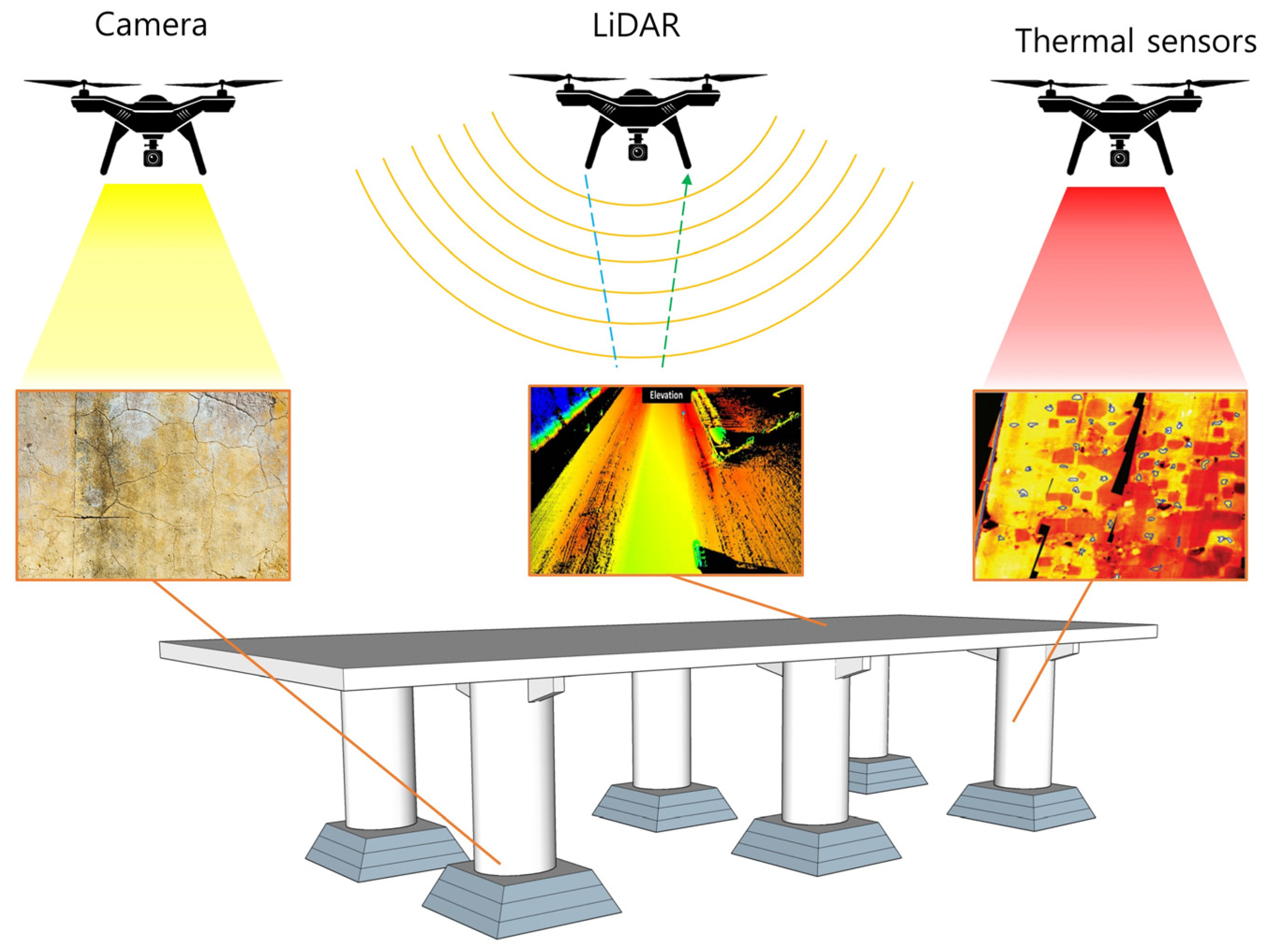
5.1. High Resolution Camera-Based Inspection with Drone

Drones have revolutionized the field of bridge maintenance. The ability to inspect bridges from the air provides engineers and maintenance crews with valuable data that can be used to ensure the safety and structural integrity of bridges. Drones equipped with cameras are particularly useful for bridge inspections as they can capture high-resolution images of the structure, allowing for a more detailed analysis of damage. One of the main advantages of using drones for bridge inspections is the increased safety they provide [130,131,132,133,134,135,136,137]. Drones can access areas that are difficult or dangerous for humans to reach, such as the underside of bridges or high above the ground. This reduces the need for maintenance workers to use scaffolding or other equipment, which can be expensive and time-consuming to set up. Additionally, drones can be operated remotely, reducing the risk of injury to maintenance workers who would otherwise have to climb the bridge structure to perform inspections. Another benefit of using drones for bridge inspections is the speed at which they can complete inspections. Drones can quickly fly over the bridge, capturing images and videos that can be analyzed in real-time. This allows for a faster turnaround time for inspection reports, reducing downtime for the bridge and minimizing disruption to traffic.
The high-resolution images and videos captured by drones can reveal details that may be missed during a visual inspection by human inspectors. This can include cracks or other signs of wear that are not immediately visible to the naked eye [138,139,140]. By providing a more detailed analysis of the bridge, maintenance crews can identify potential problems before they become serious issues, reducing the need for costly repairs and extending the lifespan of the bridge. In addition to inspections, drones can also be used for ongoing monitoring of bridge conditions. They can be programmed to fly over the bridge at regular intervals and capture data on changes in the structure over time. This can help maintenance workers identify potential problems before they become a serious issue. For example, drones can be used to monitor changes in the condition of the bridge after extreme weather events such as floods, typhoons, and earthquakes [141,142,143].
One of the challenges of using drones for bridge maintenance is the need for skilled operators. Drones require a trained operator who can maneuver the drone safely and capture high-quality images and videos. Additionally, the analysis of the data captured by the drone requires specialized knowledge and expertise. Therefore, it is essential to have a team of skilled professionals to operate the drones and analyze the data.
The concept of using a drone equipped with a camera for damage detection of structures can be seen in Figure 8. Once the images are captured from the camera, it is transferred to a computer for image processing to enhance the quality of the images, improve contrast, and reduce noise or distortion. Then, various image analysis algorithms can be employed to automatically detect and locate cracks in the processed images. These algorithms typically involve edge detection, texture analysis, or pattern recognition techniques to identify regions that indicate crack presence. Here, detected cracks can be classified based on their characteristics, such as length, width, orientation, or severity. It is worth noting that the effectiveness of high-resolution cameras for crack detection depends on various factors, such as the image quality, lighting conditions, surface texture, and the expertise of the image analysts. It is important to establish appropriate standards and guidelines for image capture, processing, and analysis to ensure accurate and reliable crack detection results. Additionally, the integration of advanced technologies such as artificial intelligence (AI) and machine learning can enhance crack detection capabilities by training algorithms to recognize and classify cracks more accurately, thereby improving the efficiency and effectiveness of the process.

5.2. Drone Equipped with LiDAR for Structure Maintenance

LiDAR is a remote sensing technology that uses laser light to measure distances and create detailed 3D maps of the surroundings. It is often referred to as the optical equivalent of radar, as it uses light instead of radio waves. In a typical LiDAR system, a laser emitter emits short pulses of laser light, usually in the infrared range. These pulses of light are directed towards the target object. When the laser light hits an object, a fraction of the light is reflected back towards the LiDAR system where the time taken for the laser light to return is calculated to measure the distance between the system and the object. By combining these distance measurements with the known position and orientation of the LiDAR device, a point cloud of the surrounding environment can be generated, which represents the location and shape of objects.
Drones equipped with LiDAR technology can be a powerful tool for structure maintenance to ensure safety as they offer a wide range of advantages and opportunities for efficient and effective inspection and monitoring of various structures, including buildings, bridges, and industrial facilities. The ability to generate accurate 3D point cloud data of structures can be utilized for the precise mapping, modeling, and visualization of the structure, providing valuable insights for maintenance and assessment purposes [145,146,147,148]. These data can be processed and analyzed to detect and identify various structural issues, including cracks, deformations, and corrosion [131,149]. By comparing the captured data with reference models or previous scans, changes in the structure’s condition can be identified, allowing for timely maintenance interventions and the prevention of further deterioration or failure.
While the utilization of LiDAR-equipped drones for structure maintenance holds immense potential, it is important to consider the challenges associated with this technology. Data processing complexity is one such challenge, as the captured LiDAR data require specialized software and expertise to convert it into useful information for analysis [150,151]. Skilled operators are required to operate the drones and process the collected data effectively. Another challenge lies in adverse weather conditions. Rain, fog, or other inclement weather can affect the performance of LiDAR systems, potentially reducing data quality or hindering data collection altogether. This limitation necessitates careful planning and scheduling of drone operations to ensure optimal weather conditions for data collection. Sensor accuracy is another aspect that requires attention. While LiDAR sensors offer high precision, variations in sensor quality or calibration can impact the accuracy of the captured data. The regular calibration and maintenance of the LiDAR system are crucial to ensure reliable and accurate measurements. Signal interference is also a consideration when using LiDAR-equipped drones. Obstacles such as trees, power lines, or other structures in the vicinity can obstruct the LiDAR signals, leading to incomplete or distorted data. Proper flight planning and obstacle avoidance algorithms are essential to mitigate these interference issues and ensure data integrity.
To address these challenges, researchers are exploring advanced data processing techniques to streamline the analysis of LiDAR data and extract meaningful information more efficiently. Improved sensor technologies and calibration methods are being developed to enhance the accuracy and reliability of LiDAR measurements [152,153,154,155]. Moreover, advancements in drone navigation and obstacle avoidance systems are being pursued to ensure safer and more precise operations, even in complex environments [156,157,158,159,160]. Integration with other sensing technologies, such as thermal imaging or multispectral cameras, is also being explored to enhance the inspection capabilities of LiDAR-equipped drones and enable a more comprehensive assessment of structural conditions.

5.3. Drones Equipped with Thermal Camera for Structure Maintenance

Thermal cameras mounted on drones enable the capture of thermal images, providing valuable insights into temperature variations and potential issues within the structures being inspected [118,161,162,163]. Thermal cameras capture infrared radiation emitted by objects, allowing the visualization of temperature variations. By detecting these temperature differences, thermal camera drones can identify various structural issues, including insulation problems, moisture infiltration, electrical faults, and thermal bridges. The ability to identify these anomalies at an early stage enables proactive maintenance and prevents further damage or deterioration.
Once thermal images are acquired, image processing and analysis techniques are employed to extract valuable information and identify potential anomalies. Image enhancement, noise reduction, and temperature calibration are crucial steps in preparing the thermal data for analysis. Advanced algorithms and machine learning approaches can be applied to automate the anomaly detection process, improving efficiency and reducing the burden on inspectors.
Several case studies and real-world applications have demonstrated the effectiveness of thermal camera drones in structure maintenance. These applications include monitoring the energy efficiency of buildings, assessing the integrity of infrastructure, inspecting solar panels, and identifying insulation or HVAC (heating, ventilation and air conditioning) system failures. The use of thermal camera drones for structure maintenance offers significant advantages in terms of accessibility, early anomaly detection, and cost-effectiveness. With continued advancements in drone technology, thermal imaging capabilities, and data analysis techniques, the integration of thermal camera drones into standard maintenance practices holds immense potential for enhancing the safety and longevity of structures.

6. Challenges and Opportunities

With the opportunities provided by the wide application of drones using in civil engineering projects, there are still challenges that need to be addressed to fully leverage the potential of drone technology in this field. For all three phases of design, construction, and maintenance, one of the crucial challenges is its limited flight time and range as battery life remains a significant constraint for drones. Most commercial drones have relatively short flight durations, limiting their ability to cover large construction sites or inspect extensive infrastructure. This limitation hampers their overall operational efficiency, requiring frequent battery replacements and recharging. Currently, research and development efforts are continuously improving battery energy density and recharge rates, allowing drones to operate for longer periods and cover greater distances. The adoption of alternative power sources, such as fuel cells, solar panels, or wireless charging, could potentially eliminate the need for frequent battery replacements, enhancing operational efficiency. Environmental conditions such as strong winds, rain or fog can impede drone operations affecting project time which is another challenge for drones. Drones are susceptible to turbulence caused by high winds, and precipitation can damage sensitive electronic components, leading to potential downtime and increased maintenance costs. Designing drones with robust structures, waterproofing, and advanced navigation systems can enable them to withstand harsh weather elements and continue operations in challenging environments safely. With the opportunities that lie ahead with drone technologies to improve safety at construction sites, monitoring processes, surveys, 3D modeling and more, civil engineers can harness the capabilities of drones to drive innovation, optimize project management, and promote safer and more sustainable infrastructure development.

7. Future Directions

Over the years, drone technology has evolved and become more sophisticated, offering a wide range of applications in areas such as those shown in this study. From this, we can predict that future drones will be equipped with advanced automation and AI capabilities to conduct missions with minimal human intervention such as autonomous flight planning and obstacle avoidance. AI-powered drones can autonomously navigate complex terrains, identify and assess potential hazards, and conduct advanced data analysis. This automation streamlines data collection, data processing, and reporting, enabling civil engineers to make informed decisions faster and more accurately. Furthermore, improvements in battery technology and drone design will lead to extended flight times to allow drones to cover large areas in a single flight, making them more effective for tasks where an extensive reviewer works on energy storage systems, as can be found in reference [164].
An extremely encouraging prospect for the future of drone applications in the civil industry involves incorporating 5G connectivity. The advanced capabilities of 5G networks, including substantially higher data transfer rates, remarkably low latency, and expanded capacity, enable seamless real-time communication between drones and ground stations. Through the implementation of 5G-enabled drones, civil engineers gain the ability to remotely oversee construction sites and infrastructure with enhanced accuracy and efficiency. This seamless exchange of high-resolution data and live video feeds empowers them to make agile decisions, enabling swift responses to dynamic project conditions. Collaborative swarm technology is another area which needs to be further researched in the future for drones as their ability to operate in swarms will revolutionize various civil industries. Drones working together will enhance efficiency and data collection capabilities which can be applied at construction sites. Such technology could possibly increase the demand for drones and with the increase in numbers, one cannot ignore that there will be a strong emphasis on making drones more environmentally friendly and sustainable. This could involve using bio-inspired designs, energy-efficient propulsion systems, Micro Air Vehicles [165], and materials with reduced environmental impact.

8. Conclusions

In conclusion, the review of drone applications in the construction industry underscores their significant contributions across various phases of the construction process, including design, construction, and maintenance. The utilization of different types of drones has proven to be immensely beneficial in enhancing efficiency, accuracy, and safety within the industry.
During the design phase, drones equipped with high-resolution cameras and advanced mapping capabilities have revolutionized site surveys and aerial mapping. These drones enable construction professionals to gather precise data, generate accurate 3D models, and assess topography. This, in turn, facilitates informed decision-making and enhances the overall design process. In the construction phase, drones have played a vital role in monitoring construction progress, conducting inspections, and ensuring safety. Equipped with real-time video transmission and thermal imaging cameras, drones provide a comprehensive and timely overview of the construction site, identifying potential issues for increasing productivity. Furthermore, drones have also demonstrated their utility in the maintenance phase of construction projects. By conducting routine inspections of structures, buildings, and infrastructure, drones efficiently detect and identify any damages, enabling proactive maintenance, cost reduction, and the prolongation of asset lifespan.
Overall, the integration of drones in the construction industry has brought about transformative advancements in efficiency, accuracy, and safety across all phases of the construction process. As technology continues to advance, it is expected that drones will increasingly play a critical role in shaping the future of the construction industry, empowering professionals to achieve higher productivity, minimize risks, and deliver projects of exceptional quality.

Author Contributions

H.-W.C. was responsible for the conceptualization and methodology of the work; H.-J.K. carried out the investigation and participated in writing the manuscript. S.-K.K. supervised the manuscript and W.S.N. supervised and carried out the reviewing and editing of the manuscript. All authors have read and agreed to the published version of the manuscript.

Funding

This research was conducted with the support of the “National R&D Project for Smart Construction Technology (RS-2020-KA157089, 4th year)” funded by the Korea Agency for Infrastructure Technology Advancement under the Ministry of Land, Infrastructure and Transport, and managed by the Korea Expressway Corporation.

Institutional Review Board Statement

Not applicable.

Informed Consent Statement

Not applicable.

Data Availability Statement

Not applicable.

Conflicts of Interest

The authors declare no conflict of interest.

References

  1. Shanti, M.Z.; Cho, C.S.; de Soto, B.G.; Byon, Y.J.; Yeun, C.Y.; Kim, T.Y. Real-time monitoring of work-at-height safety hazards in construction sites using drones and deep learning. J. Saf. Res. 2022, 83, 364–370. [Google Scholar] [CrossRef]
  2. Zhang, Y.; Zhang, K. Design of Construction Site Dust Detection System Based on UAV Flying Platform. In Proceedings of the IEEE International Conference on Control Science and Electric Power Systems (CSEPS), Shanghai, China, 28–30 May 2021; pp. 148–151. [Google Scholar]
  3. Olivatto, T.F.; Inguaggiato, F.F.; Stanganini, F.N. Urban mapping and impacts assessment in a Brazilian irregular settlement using UAV-based imaging. Remote Sens. Appl. Soc. Environ. 2023, 29, 100911. [Google Scholar]
  4. Fan, J.; Saadeghvaziri, M.A. Applications of drones in infrastructures: Challenges and opportunities. Int. J. Mech. Mechatron. Eng. 2019, 13, 649–655. [Google Scholar]
  5. Tao, C.; Zhu, K.; Chen, B.; Zhao, Y. UAV-assisted ground signal map construction based on 3-D spatial correlation. In Proceedings of the GLOBECOM 2020—2020 IEEE Global Communications Conference, Taipei, Taiwan, 7–11 December 2020; pp. 1–5. [Google Scholar]
  6. Tatum, M.C.; Liu, J. Unmanned aircraft system applications in construction. Procedia Eng. 2017, 196, 167–175. [Google Scholar] [CrossRef]
  7. Liu, Q.; Chen, B.; Yan, Y.; Zhang, C. A measurement method for construction planning and completion based on UAV photography. In Proceedings of the 2022 4th International Conference on Intelligent Control, Measurement and Signal Processing (ICMSP), Hangzhou, China, 8–10 July 2022; pp. 148–151. [Google Scholar]
  8. Zhang, C.; Wang, F.; Zou, Y.; Dimyadi, J.; Guo, B.H.; Hou, L. Automated UAV image-to-BIM registration for building façade inspection using improved generalised Hough transform. Autom. Constr. 2023, 153, 104957. [Google Scholar] [CrossRef]
  9. Hamledari, H.; Sajedi, S.; McCabe, B.; Fischer, M. Automation of Inspection Mission Planning Using 4D BIMs and in Support of Unmanned Aerial Vehicle–Based Data Collection. J. Constr. Eng. Manag. 2021, 147, 04020179. [Google Scholar] [CrossRef]
  10. Ruiz, R.D.B.; Lordsleem, A.C., Jr.; Rocha, J.H.A.; Irizarry, J. Unmanned Aerial Vehicles (UAV) as a Tool for Visual Inspection of Building Facades in AEC+FM Industry. Constr. Innov. 2021, 22, 1155–1170. [Google Scholar] [CrossRef]
  11. Petritoli, E.; Leccese, F.; Ciani, L. Reliability Degradation, Preventive and Corrective Maintenance of UAV Systems. In Proceedings of the 2018 5th IEEE International Workshop on Metrology for AeroSpace (MetroAeroSpace), Rome, Italy, 20–22 June 2018; pp. 430–434. [Google Scholar]
  12. Sowing UAV of Fixed Wings. Available online: https://www.uavos.com/products/fixed-wing-uavs/sitaria-e/ (accessed on 15 June 2023).
  13. Sowing UAV of Quadcopter. Available online: https://www.ubuy.dk/en/product/1E71NHFK-dji-air-2s-drone-quadcopter-uav-with-3-axis-gimbal-camera-5-4k-video-1-inch-cmos-sensor-4-directions (accessed on 8 June 2023).
  14. Sowing UAV of Hexacopter. Available online: https://www.best-quadcopter.com/reviews/2017/03/yuneec-typhoon-h-pro-realsense-obstacle-avoiding-drone/ (accessed on 28 June 2023).
  15. Sowing UAV of Octocoptor. Available online: https://kr.made-in-china.com/co_agriculture-drone/image_30L-Payload-RC-8-Propellers-Professional-Plant-Protection-Drone_eeeessrsy_2f1j00AkmWNvsHpOrU.html (accessed on 1 June 2023).
  16. Sowing UAV of Hybrid. Available online: https://www.viewprouav.com/product/tiger-shark-f380-heavy-lift-hybrid-vtol-fixed-wing-with-3-8m-wingspan-10kg-load-capacity.html (accessed on 3 June 2023).
  17. Calantropio, A.; Chiabrando, F.; Sammartano, G.; Spanò, A.; Teppati Losè, L. UAV Strategies validation and remote sensing data for damage assessment in post-disaster scenarios. Int. Arch. Photogramm. Remote Sens. Spat. Inf. Sci. 2018, 42, 121–128. [Google Scholar] [CrossRef] [Green Version]
  18. Villanueva, J.R.E.; Martínez, L.I.; Montiel, J.I.P. DEM Generation from Fixed-Wing UAV Imaging and LiDAR-Derived Ground Control Points for Flood Estimations. Sensors 2019, 19, 3205. [Google Scholar]
  19. Templin, T.; Popielarczyk, D.; Kosecki, R. Application of Low-Cost Fixed-Wing UAV for Inland Lakes Shoreline Investigation. Pure Appl. Geophys. 2018, 175, 3263–3283. [Google Scholar] [CrossRef] [Green Version]
  20. Anders, N.; Masselink, R.; Keesstra, S.; Suomalainen, J. High-Res Digital Surface Modeling using Fixed-Wing UAV-based Photogrammetry. In Proceedings of the Geomorphometry 2013, Nanjing, China, 16–20 October 2013; pp. 2–5. [Google Scholar]
  21. Yi, W.; Liming, C.; LingYu, K.; Jie, Z.; Miao, W. Research on application mode of large fixed-wing UAV system on overhead transmission line. In Proceedings of the IEEE International Conference on Unmanned Systems (ICUS), Beijing, China, 27–29 October 2017; pp. 88–91. [Google Scholar]
  22. El Tin, F.; Sharf, I.; Nahon, M. Fire Monitoring with a Fixed-wing Unmanned Aerial Vehicle. In Proceedings of the 2022 International Conference on Unmanned Aircraft Systems (ICUAS), Dubrovnik, Croatia, 21–24 June 2022; pp. 1350–1358. [Google Scholar]
  23. Sonkar, S.; Kumar, P.; George, R.C.; Yuvaraj, T.P.; Philip, D.; Ghosh, A.K. Real-time object detection and recognition using fixed-wing Lale VTOL UAV. IEEE Sens. J. 2022, 22, 20738–20747. [Google Scholar] [CrossRef]
  24. Khan, S.; Bendoukha, S.; Naeem, W.; Iqbal, J. Experimental validation of an integral sliding mode-based LQG for the pitch control of a UAV-mimicking platform. Adv. Electr. Electron. Eng. 2019, 17, 275–284. [Google Scholar]
  25. Chae, M.H.; Park, S.O.; Choi, S.H.; Choi, C.T. Commercial Fixed-Wing Drone Redirection System using GNSS Deception. IEEE Trans. Aerosp. Electron. Syst. 2023, 1–15. [Google Scholar] [CrossRef]
  26. Sujit, P.B.; Saripalli, S.; Sousa, J.B. Unmanned Aerial Vehicle Path Following: A Survey and Analysis of Algorithms for Fixed-Wing Unmanned Aerial Vehicless. IEEE Control Syst. Mag. 2014, 34, 42–59. [Google Scholar]
  27. Jin, J.W.; Miwa, M.; Shim, J.H. Design and construction of a Quad tilt-Rotor UAV using servo motor. J. Eng. Educ. Res. 2014, 17, 17–22. [Google Scholar]
  28. Yang, H.; Lee, Y.; Jeon, S.-Y.; Lee, D. Multi-rotor drone tutorial: Systems, mechanics, control and state estimation. Intell. Serv. Robot. 2017, 10, 79–93. [Google Scholar] [CrossRef]
  29. Altınuç, K.O.; Khan, M.U.; Iqbal, J. Avoiding contingent incidents by quadrotors due to one or two propellers failure. PLoS ONE 2023, 18, e0282055. [Google Scholar] [CrossRef]
  30. Freimuth, H.; König, M. Planning and Executing Construction Inspections with Unmanned Aerial Vehicles. Autom. Constr. 2018, 96, 540–553. [Google Scholar] [CrossRef]
  31. Kim, S.S. Opportunities for construction site monitoring by adopting first personal view (FPV) of a drone. Smart Struct. Syst. 2018, 21, 139–149. [Google Scholar]
  32. Deng, C.; Wang, S.; Huang, Z.; Tan, Z.; Liu, J. Unmanned Aerial Vehicles for power line inspection: A cooperative way in platforms and communications. J. Commun. 2014, 9, 687–692. [Google Scholar] [CrossRef] [Green Version]
  33. Boon, M.A.; Drijfhout, A.P.; Tesfamichael, S. Comparison of a fixed-wing and multi-rotor UAV for environmental mapping applications: A case study. Int. Arch. Photogramm. Remote Sens. Spat. Inf. Sci. 2017, 42, 47. [Google Scholar]
  34. Thibbotuwawa, A.; Bocewicz, G.; Radzki, G.; Nielsen, P.; Banaszak, Z. UAV Mission Planning Resistant to Weather Uncertainty. Sensors 2020, 20, 515. [Google Scholar] [CrossRef] [PubMed] [Green Version]
  35. Eck, C.; Imbach, B. Aerial magnetic sensing with an UAV helicopter. Int. Arch. Photogramm. Remote Sens. Spat. Inf. Sci. 2011, 38, 81–85. [Google Scholar] [CrossRef] [Green Version]
  36. Li, X.; Wu, J. Extracting High-Precision Vehicle Motion Data from Unmanned Aerial Vehicle Video Captured under Various Weather Conditions. Remote Sens. 2022, 14, 5513. [Google Scholar] [CrossRef]
  37. Al-Rawabdeh, A.; He, F.; Moussa, A.; El-Sheimy, N.; Habib, A. Using an Unmanned Aerial Vehicle-Based Digital Imaging System to Derive a 3D Point Cloud for Landslide Scarp Recognition. Remote Sens. 2016, 8, 95. [Google Scholar] [CrossRef] [Green Version]
  38. Jacob-Loyola, N.; Munoz-La Rivera, F.; Herrera, R.F.; Atencio, E. Unmanned aerial vehicles (uavs) for physical progress monitoring of construction. Sensors 2021, 21, 4227. [Google Scholar] [CrossRef] [PubMed]
  39. Motawa, I.; Kardakou, A. Unmanned aerial vehicles (UAVs) for inspection in construction and building industry. In Proceedings of the the 16th International Operation and Maintenance Conference, Cairo, Egypt, 18–20 November 2018. [Google Scholar]
  40. Khaloo, A.; Lattanzi, D.; Cunningham, K.; Dell’Andrea, R.; Riley, M. Unmanned aerial vehicle inspection of the Placer River Trail Bridge through image-based 3D modelling. Struct. Infrastruct. Eng. 2018, 14, 124–136. [Google Scholar] [CrossRef]
  41. Lindner, G.; Schraml, K.; Mansberger, R.; Hübl, J. Uav monitoring and documentation of a large landslide. Appl. Geomat. 2016, 8, 1–11. [Google Scholar] [CrossRef]
  42. Panigrahi, S.; Krishna, Y.S.S.; Thondiyath, A. Design, Analysis, and Testing of a Hybrid VTOL Tilt-Rotor UAV for Increased Endurance. Sensors 2021, 21, 5987. [Google Scholar] [CrossRef]
  43. Gunarathna, J.K.; Munasinghe, R. Development of a quad-rotor fixed-wing hybrid unmanned aerial vehicle. In Proceedings of the 2018 Moratuwa Engineering Research Conference (MERCon), Moratuwa, Sri Lanka, 30 May–1 June 2018; pp. 72–77. [Google Scholar]
  44. Saeed, A.S.; Younes, A.B.; Cai, C.; Cai, G. A Survey of Hybrid Unmanned Aerial Vehicles. Prog. Aerosp. Sci. 2018, 98, 91–105. [Google Scholar] [CrossRef]
  45. Yuksek, B.; Vuruskan, A.; Ozdemir, U.; Yukselen, M.A.; Inalhan, G. Transition flight modeling of a fixed-wing VTOL UAV. J. Intell. Robot. Syst. 2016, 84, 83–105. [Google Scholar] [CrossRef]
  46. Nguyen, K.D.; Ha, C.; Jang, J.T. Development of a new hybrid drone and software-in-the-loop simulation using px4 code. In Intelligent Computing Theories and Application, Proceedings of the International Conference on Intelligent Computing, Wuhan, China, 15–18 August 2018; Springer: Cham, Switzerland, 2018; pp. 84–93. [Google Scholar]
  47. Asadi, K.; Kalkunte Suresh, A.; Ender, A.; Gotad, S.; Maniyar, S.; Anand, S.; Noghabaei, M.; Han, K.; Lobaton, E.; Wu, T. An integrated UGV-UAV system for construction site data collection. Autom. Constr. 2020, 112, 103068. [Google Scholar] [CrossRef]
  48. Congress, S.S.C.; Puppala, A.J. A Road Map for Geotechnical Monitoring of Transportation Infrastructure Assets Using Three-Dimensional Models Developed from Unmanned Aerial Data. Indian Geotech. J. 2021, 51, 84–96. [Google Scholar] [CrossRef]
  49. Bang, S.; Kim, H.; Kim, H. UAV-Based Automatic Generation of High-Resolution Panorama at a Construction Site with a Focus on Preprocessing for Image Stitching. Autom. Constr. 2017, 84, 70–80. [Google Scholar] [CrossRef]
  50. Kim, P.; Park, J.; Cho, Y. As-Is Geometric Data Collection and 3D Visualization through the Collaboration between UAV and UGV. In Proceedings of the 36th International Symposium on Automation and Robotics in Construction (ISARC), Banff, AB, Canada, 21–24 May 2019; Al-Hussein, M., Ed.; International Association for Automation and Robotics in Construction (IAARC): Banff, AB, Canada, 2019; pp. 544–551. [Google Scholar]
  51. Giordan, D.; Adams, M.S.; Aicardi, I.; Alicandro, M.; Allasia, P.; Baldo, M.; De Berardinis, P.; Dominici, D.; Godone, D.; Hobbs, P.; et al. The use of unmanned aerial vehicles (UAVs) for engineering geology applications. Bull. Int. Assoc. Eng. Geol. 2020, 79, 3437–3481. [Google Scholar] [CrossRef] [Green Version]
  52. Bemis, S.P.; Micklethwaite, S.; Turner, D.; James, M.R.; Akciz, S.; Thiele, S.T.; Bangash, H.A. Ground-based and UAV-Based photogrammetry: A multi-scale, high-resolution mapping tool for structural geology and paleoseismology. J. Struct. Geol. 2014, 69, 163–178. [Google Scholar] [CrossRef]
  53. Westoby, M.J.; Brasington, J.; Glasser, N.F.; Hambrey, M.J.; Reynolds, J. Structure-from-Motion’photogrammetry: A low-cost, effective tool for geoscience applications. Geomorphology 2012, 179, 300–314. [Google Scholar] [CrossRef] [Green Version]
  54. Ajayi, O.G.; Palmer, M.; Salubi, A.A. Modelling farmland topography for suitable site selection of dam construction using unmanned aerial vehicle (UAV) photogrammetry. Remote Sens. Appl. Soc. Environ. 2018, 11, 220–230. [Google Scholar]
  55. Dominici, D.; Alicandro, M.; Massimi, V. Uav photogrammetry in the post-earthquake scenario: Case studies in l’aquila. Geomat. Nat. Hazards Risk 2017, 8, 87–103. [Google Scholar] [CrossRef] [Green Version]
  56. Park, J.; Im, S.; Lee, K.H.; Lee, J.O. Vision-based SLAM system for small UAVs in GPS-denied environments. J. Aerosp. Eng. 2012, 25, 519–529. [Google Scholar] [CrossRef]
  57. Chesley, J.T.T.; Leier, A.L.L.; White, S.; Torres, R. Using unmanned aerial vehicles and structure-from-motion photogrammetry to characterize sedimentary outcrops: An example from the Morrison Formation, Utah, USA. Sediment. Geol. 2017, 354, 1–8. [Google Scholar]
  58. Hammad, A.W.A.; da Costa, B.B.F.; Soares, C.A.P.; Haddad, A.N. The Use of Unmanned Aerial Vehicles for Dynamic Site Layout Planning in Large-Scale Construction Projects. Buildings 2021, 11, 602. [Google Scholar] [CrossRef]
  59. Han, K.K.; Golparvar-Fard, M. Potential of Big Visual Data and Building Information Modeling for Construction Performance Analytics: An Exploratory Study. Autom. Constr. 2017, 73, 184–198. [Google Scholar] [CrossRef] [Green Version]
  60. Siebert, S.; Teizer, J. Mobile 3D mapping for surveying earthwork projects using an unmanned aerial vehicle(UAV) system. Autom. Constr. 2014, 41, 1–14. [Google Scholar] [CrossRef]
  61. Razzaq, S.; Xydeas, C.; Mahmood, A.; Ahmed, S.; Ratyal, N.I.; Iqbal, J. Efficient optimization techniques for resource allocation in UAVs mission framework. PLoS ONE 2023, 18, e0283923. [Google Scholar] [CrossRef]
  62. Han, Y.; Feng, D.; Wu, W.; Yu, X.; Wu, G.; Liu, J. Geometric shape measurement and its application in bridge construction based on UAV and terrestrial laser scanner. Autom. Constr. 2023, 151, 104880. [Google Scholar] [CrossRef]
  63. Keyvanfar, A.; Shafaghat, A.; Rosley, M.S. Performance comparison analysis of 3D reconstruction modeling software in construction site visualization and mapping. Int. J. Archit. Computing. 2022, 20, 453–475. [Google Scholar]
  64. Jiménez-Jiménez, S.I.; Ojeda-Bustamante, W.; Marcial-Pablo, M.; Enciso, J. Digital Terrain Models Generated with Low-Cost UAV Photogrammetry: Methodology and Accuracy. ISPRS Int. J. Geo-Inf. 2021, 10, 285. [Google Scholar]
  65. Baker, W.J., III; Meehan, C.L. Spatial Interpolation of UAV Survey Data for Lift Thickness Determination during Earthwork Construction. In Proceedings of the Geo-Congress 2023, Los Angeles, CA, USA, 26–29 March 2023; pp. 336–346. [Google Scholar]
  66. Kim, J.; Lee, S.; Seo, J.; Lee, D.-E.; Choi, H. The Integration of Earthwork Design Review and Planning Using UAV-Based Point Cloud and BIM. Appl. Sci. 2021, 11, 3435. [Google Scholar] [CrossRef]
  67. Kavaliauskas, P.; Židanavičius, D.; Jurelionis, A. Geometric Accuracy of 3D Reality Mesh Utilization for BIM-Based EarthworkQuantity Estimation Workflows. ISPRS Int. J. Geo-Inf. 2021, 10, 399. [Google Scholar] [CrossRef]
  68. Hasegawa, H.; Sujaswara, A.A.; Kanemoto, T.; Tsubota, K. Possibilities of Using UAV for Estimating Earthwork Volumes during Process of Repairing a Small-Scale Forest Road, Case Study from Kyoto Prefecture, Japan. Forests 2023, 14, 677. [Google Scholar] [CrossRef]
  69. Rachmawati, T.S.N.; Park, H.C.; Kim, S. A Scenario-Based Simulation Model for Earthwork Cost Management Using Unmanned Aerial Vehicle Technology. Sustainability 2023, 15, 503. [Google Scholar]
  70. Park, H.C.; Rachmawati, T.S.N.; Kim, S. UAV-Based High-Rise Buildings Earthwork Monitoring—A Case Study. Sustainability 2022, 14, 10179. [Google Scholar] [CrossRef]
  71. Ostrovskyi, A.; Kolb, I.; Vivat, A.; Lozynskyi, V.; Zhyvchuk, V. Simplified method of obtaining data for calculating the volume of earthworks based on aerial survey materials from UAVs. In Proceedings of the International Conference of Young Professionals «GeoTerrace-2021», Lviv, Ukraine, 4–6 October 2021; Volume 1, pp. 1–5. [Google Scholar]
  72. Kim, D.; Liu, M.; Lee, S.; Kamat, V.R. Remote proximity monitoring between mobile construction resources using camera-mounted UAVs. Autom. Constr. 2019, 99, 168–182. [Google Scholar] [CrossRef]
  73. Kim, D.; Yin, K.; Liu, M.; Lee, S.; Kamat, V.R. Feasibility of a Drone-Based On-Site Proximity Detection in an Outdoor Construction Site. In Proceedings of the ASCE International Workshop on Computing in Civil Engineering 2017, Seattle, WA, USA, 25–27 June 2017; pp. 392–400. [Google Scholar]
  74. Wu, J.; Peng, L.; Li, J.; Zhou, X.; Zhong, J.; Wang, C.; Sun, J. Rapid safety monitoring and analysis of foundation pit construction using unmanned aerial vehicle images. Autom. Constr. 2021, 128, 103706. [Google Scholar]
  75. Kim, Y.H.; Shin, S.S.; Lee, H.K.; Park, E.S. Field Applicability of Earthwork Volume Calculations Using Unmanned Aerial Vehicle. Sustainability 2022, 14, 9331. [Google Scholar]
  76. Lee, K.; Lee, W.H. Earthwork Volume Calculation, 3D Model Generation, and Comparative Evaluation Using Vertical and High-Oblique Images Acquired by Unmanned Aerial Vehicles. Aerospace 2022, 9, 606. [Google Scholar] [CrossRef]
  77. Lee, S.B.; Han, D.; Song, M. Calculation and Comparison of Earthwork Volume Using Unmanned Aerial Vehicle Photogrammetry and Traditional Surveying Method. Sens. Mater. 2022, 34, 4737–4753. [Google Scholar]
  78. Ajayi, O.G.; Ajulo, J. Investigating the Applicability of Unmanned Aerial Vehicles (UAV) Photogrammetry for the Estimation ofthe Volume of Stockpiles. Quaest. Geogr. 2021, 40, 25–38. [Google Scholar] [CrossRef]
  79. Astor, Y.; Utami, R.; Gustaman, F.A.; Ramdani, M.A.; Pangestu, Y.I. Implementation of Unmanned Aerial Vehicle (UAV) in the Sand Mine Project. In Conference on Broad Exposure to Science and Technology 2021 (BEST 2021); Atlantis Press: Amsterdam, The Netherlands, 2022; pp. 66–71. [Google Scholar]
  80. Villalobos, N.; Alzraiee, H. Earthwork Surface Creation and Volume Computation Using UAV 3D Mapping. In Proceedings of the Construction Research Congress 2022, Arlington, VA, USA, 9–12 March 2022; pp. 1243–1252. [Google Scholar]
  81. Subramaniam, T.R.; Suhaimi, N.N.A.; Paizol, A.; Nor, A.H.M. Determination of Slope Stability using (UAV) Unmanned Aerial Vehicle. Multidiscip. Appl. Res. Innov. 2022, 3, 292–301. [Google Scholar]
  82. Pasternak, G.; Zaczek-Peplinska, J.; Pasternak, K.; Jóźwiak, J.; Pasik, M.; Koda, E.; Vaverková, M.D. Surface Monitoring of an MSW Landfill Based on Linear and Angular Measurements, TLS, and LIDAR UAV. Sensors 2023, 23, 1847. [Google Scholar]
  83. Cho, J.; Lee, J.; Lee, B. Application of UAV Photogrammetry to Slope-Displacement Measurement. KSCE J. Civ. Eng. 2022, 26, 1904–1913. [Google Scholar]
  84. Kielhauser, C.; Manzano, R.R.; Hoffman, J.J.; Adey, B.T. Automated Construction Progress and Quality Monitoring for Commercial Buildings with Unmanned Aerial Systems: An Application Study from Switzerland. Infrastructures 2020, 5, 98. [Google Scholar]
  85. Meshram, K.; Reddy, N.G. Development of a machine learning-based drone system for management of construction sites. In Advances in Sustainable Materials and Resilient Infrastructure; Springer: Singapore, 2022; pp. 77–78. [Google Scholar]
  86. Irizarry, J.; Costa, D.B. Exploratory study of potential applications of unmanned aerial systems for construction management tasks. J. Manag. Eng. 2016, 32, 05016001. [Google Scholar]
  87. Ngadiman, N.; Kaamin, M.; Nizam, M.A.H.M.; Johar, M.A.H.; Roslin, M.A. Unmanned aerial vehicle (UAV) visual monitoring in construction. Ann. Rom. Soc. Cell Biol. 2021, 25, 3097–3104. [Google Scholar]
  88. Keyvanfar, A.; Shafaghat, A.; Awanghamat, A. Optimization and Trajectory Analysis of Drone’s Flying and Environmental Variables for 3D Modelling the Construction Progress Monitoring. Int. J. Civ. Eng. 2021, 20, 363–388. [Google Scholar]
  89. Qu, T.; Zang, W.; Peng, Z.; Liu, J.; Li, W.; Zhu, Y.; Zhang, B.; Wang, Y. Construction Site Monitoring using UAV Oblique Phtogrammetry and BIM Technologies. In Proceedings of the 22nd CAADRIA Conference, Suzhou, China, 5–8 April 2017. [Google Scholar]
  90. Cheng, T.; Teizer, J. Real-time resource location data collection and visualization technology for construction safety and activity monitoring applications. Autom. Constr. 2013, 34, 3–15. [Google Scholar]
  91. Yang, J.; Park, M.W.; Vela, P.A.; Golparvar-Fard, M. Construction Performance Monitoring via Still Images, Time-Lapse Photos, and Video Streams: Now, Tomorrow, and the Future. Adv. Eng. Inform. 2015, 29, 211–224. [Google Scholar]
  92. Martinez, J.G.; Gheisari, M.; Alarcón, L.F. UAV integration in current construction safety planning and monitoring process: Case study of a high-rise building construction project in Chile. J. Manag. Eng. 2020, 36, 05020005. [Google Scholar]
  93. Mavroulis, S.; Andreadakis, E.; Spyrou, N.I.; Antoniou, V.; Skourtsos, E.; Papadimitriou, P.; Kasssaras, I.; Kaviris, G.; Tselentis, G.A.; Voulgaris, N.; et al. UAV and GIS based rapid earthquake-induced building damage assessment and methodology for EMS-98 isoseismal map drawing: The June 12, 2017 mw 6.3 lesvos (northeastern aegean, greece) earthquake. Int. J. Disaster Risk Reduct. 2019, 37, 20. [Google Scholar]
  94. Candigliota, E.; Immordino, F. Low Altitude Remote Sensing by UAV for monitoring and emergency management on historical heritage. In Proceedings of the ANIDIS Congress, Padova, Italy, 30 June–4 July 2013; Volume 30. [Google Scholar]
  95. Feroz, S.; Abu Dabous, S. UAV-Based Remote Sensing Applications for Bridge Condition Assessment. Remote Sens. 2021, 13, 1809. [Google Scholar] [CrossRef]
  96. Duque, L.; Seo, J.; Wacker, J. Bridge Deterioration Quantification Protocol Using UAV. J. Bridge Eng. 2018, 23, 04018080. [Google Scholar] [CrossRef]
  97. Aliyari, M.; Ashrafi, B.; Ayele, Y.Z. Hazards identification and risk assessment for UAV–assisted bridge inspections. Struct. Infrastruct. Eng. 2022, 18, 412–428. [Google Scholar] [CrossRef]
  98. Wackwitz, K.; Boedecker, H. Safety Risk Assessment for UAV Operation; Drone Industry Insights: Hamburg, Germany, 2015. [Google Scholar]
  99. Namian, M.; Khalid, M.; Wang, G.; Turkan, Y. Revealing safety risks of unmanned aerial vehicles in construction. Transp. Res. Rec. 2021, 2675, 03611981211017134. [Google Scholar] [CrossRef]
  100. Calamoneri, T.; Corò, F.; Mancini, S. A Realistic Model to Support Rescue Operations After an Earthquake via UAVs. IEEE Access 2022, 10, 6109–6125. [Google Scholar] [CrossRef]
  101. Oubbati, O.S.; Badis, H.; Rachedi, A.; Lakas, A.; Lorenz, P. Multi-UAV Assisted Network Coverage Optimization for Rescue Operations using Reinforcement Learning. In Proceedings of the 2023 IEEE 20th Consumer Communications & Networking Conference (CCNC), Las Vegas, NV, USA, 8–11 January 2023; pp. 1003–1008. [Google Scholar]
  102. Horyna, J.; Baca, T.; Walter, V.; Albani, D.; Hert, D.; Ferrante, E.; Saska, M. Decentralized swarms of unmanned aerial vehicles for search and rescue operations without explicit communication. Auton. Robot. 2023, 47, 77–93. [Google Scholar] [CrossRef]
  103. Du, Y. Multi-UAV Search and Rescue with Enhanced A Algorithm Path Planning in 3D Environment. Int. J. Aerosp. Eng. 2023, 2023, 8614117. [Google Scholar]
  104. Tu´snio, N.; Wróblewski, W. The Efficiency of Drones Usage for Safety and Rescue Operations in an Open Area: A Case from Poland. Sustainability 2022, 14, 327. [Google Scholar]
  105. Lygouras, E.; Santavas, N.; Taitzoglou, A.; Tarchanidis, K.; Mitropoulos, A.; Gasteratos, A. Unsupervised Human Detection withan Embedded Vision System on a Fully Autonomous UAV for Search and Rescue Operations. Sensors 2019, 19, 3542. [Google Scholar]
  106. Feraru, V.A.; Andersen, R.E.; Boukas, E. Towards an Autonomous UAV-Based System to Assist Search and Rescue Operations in Man Overboard Incidents. In Proceedings of the 2020 IEEE International Symposium on Safety, Security, and Rescue Robotics (SSRR), Abu Dhabi, United Arab Emirates, 4–6 November 2020; pp. 57–64. [Google Scholar]
  107. Dong, J.; Ota, K.; Dong, M. UAV-Based Real-Time Survivor Detection System in Post-Disaster Search and Rescue Operations. IEEE J. Miniaturization Air Space Syst. 2021, 2, 209–219. [Google Scholar] [CrossRef]
  108. Martinez-Alpiste, I.; Golcarenarenji, G.; Wang, Q.; Alcaraz-Calero, J.M. Search and rescue operation using UAVs: A case study. Expert Syst. Appl. 2021, 178, 114937. [Google Scholar]
  109. Goodrich, M.A.; Cooper, J.L.; Adams, J.A.; Humphrey, C.; Zeeman, R.; Buss, B.G. Using a mini-uav to support wilderness search and rescue: Practices for human-robot teaming. In Proceedings of the 2007 IEEE International Workshop on Safety, Security and Rescue Robotics, Rome, Italy, 27–29 September 2007. [Google Scholar]
  110. Koubaa, A.; Ammar, A.; Abdelkader, M.; Alhabashi, Y.; Ghouti, L. AERO: AI-Enabled Remote Sensing Observation with OnboardEdge Computing in UAVs. Remote Sens. 2023, 15, 1873. [Google Scholar]
  111. Anhammer, A.; Lundeberg, H. Autonomous UAV Path Planning Using RSS Signals in Search and Rescue Operations. Master’s Thesis, Linköping University, Linköping, Sweden, 2022. [Google Scholar]
  112. Kalatzis, N.; Avgeris, M.; Dechouniotis, D.; Papadakis-Vlachopapadopoulos, K.; Roussaki, I.; Papavassiliou, S. Edge computing in IoT ecosystems for UAV-enabled early fire detection. In Proceedings of the 2018 IEEE International Conference on Smart Computing (SMARTCOMP), Taormina, Italy, 18–20 June 2018; pp. 106–114. [Google Scholar]
  113. Van Persie, M.; Oostdijk, A.; Fix, J.; Van Sijl, M.C.; Edgardh, L. Real-time UAV based geospatial video integrated into the fire brigades crisis management GIS system. Int. Arch. Photogramm. Remote Sens. Spat. Inf. Sci. 2012, 38, 173–175. [Google Scholar] [CrossRef] [Green Version]
  114. Daniel, K.; Wietfeld, C. Using Public Network Infrastructures for UAV Remote Sensing in Civilian Security Operations; Technical University Dortmund: Dortmund, Germany, 2011. [Google Scholar]
  115. Moumgiakmas, S.S.; Samatas, G.G.; Papakostas, G.A. Computer Vision for Fire Detection on UAVs—From Software to Hardware. Future Internet 2021, 13, 200. [Google Scholar] [CrossRef]
  116. Merino, L.; Caballero, F.; Martínez-de Dios, J.; Ollero, A. Cooperative fire detection using Unmanned Aerial Vehicles. In Proceedings of the 2005 IEEE International Conference on Robotics and Automation, Barcelona, Spain, 18–22 April 2005; pp. 1884–1889. [Google Scholar]
  117. Seo, S.H.; Choi, J.I.; Song, J. Secure Utilization of Beacons and UAVs in Emergency Response Systems for Building Fire Hazard. Sensors 2017, 17, 2200. [Google Scholar] [PubMed] [Green Version]
  118. Kumarapu, K.; Shashi, M.; Keesara, V.R. UAV in Construction Site Monitoring and Concrete Strength Estimation. J. Indian Soc. Remote Sens. 2020, 49, 619–627. [Google Scholar] [CrossRef]
  119. Anwar, N.; Najam, F.A.; Izhar, M.A. Construction monitoring and reporting using drones and unmanned aerial vehicles (UAVs). In Proceedings of the Tenth International Conference on Construction in the 21st Century (CITC-10), Colombo, Sri lanka, 2–4 July 2018. [Google Scholar]
  120. Jo, D.; Kwon, Y. Development of Rescue Material Transport UAV (Unmanned Aerial Vehicle). World J. Eng. Technol. 2017, 5, 720–729. [Google Scholar] [CrossRef] [Green Version]
  121. Huang, Y.; Han, H.; Zhang, B.; Su, X.; Gong, Z. Supply distribution center planning in UAV-based logistics networks for post-disaster supply delivery. In Proceedings of the 2020 IEEE International Conference on E-health Networking, Application & Services (HEALTHCOM), Shenzhen, China, 1–2 March 2021; pp. 1–6. [Google Scholar]
  122. Wenjian, Z.; Sidong, Z.; RongJie, C.; Jingchang, X.; Yeqian, L.; Huiru, C. Design of a relief materials delivery system based on UAV. IOP Conf. Ser. Mater. Sci. Eng. 2020, 715, 012049. [Google Scholar] [CrossRef]
  123. Zhang, J.; Zhu, Y.; Wang, T.; Wang, W.; Wang, R.; Li, X. An Improved Intelligent Auction Mechanism for Emergency Material Delivery. Mathematics 2022, 10, 2184. [Google Scholar] [CrossRef]
  124. Zhang, R.; Dou, L.; Xin, B.; Chen, C.; Deng, F.; Chen, J. A Review on the Truck and Drone Cooperative Delivery Problem. Unmanned Syst. 2023, 12, 1–25. [Google Scholar]
  125. Amicone, D.; Cannas, A.; Marci, A.; Tortora, G. A Smart Capsule Equipped with Artificial Intelligence for Autonomous Delivery of Medical Material through Drones. Appl. Sci. 2021, 11, 7976. [Google Scholar]
  126. Kim, J.; Moon, H.; Jung, H. Drone-Based Parcel Delivery Using the Rooftops of City Buildings: Model and Solution. Appl. Sci. 2020, 10, 4362. [Google Scholar]
  127. Saponi, M.; Borboni, A.; Adamini, R.; Faglia, R.; Amici, C. Embedded Payload Solutions in UAVs for Medium and Small Package Delivery. Machines 2022, 10, 737. [Google Scholar] [CrossRef]
  128. Ragauskas, U.; Bručas, D.; Sužiedelytė Visockienė, J. Research of remotely piloted vehicles for cargo transportation. Aviation 2016, 20, 14–20. [Google Scholar] [CrossRef]
  129. Olsen, M.J.; Parrish, C.; Che, E.; Jung, J.; Greenwood, J. Lidar for Maintenance of Pavement Reflective Markings and Retroreflective Signs (No. FHWA-OR-RD-19-01); Oregon Department of Transportation: Salem, OR, USA, 2018. [Google Scholar]
  130. Escobar-Wolf, R.; Oommen, T.; Brooks, C.N.; Dobson, R.J.; Ahlborn, T.M. Unmanned Aerial Vehicle (UAV)-Based Assessment of Concrete Bridge Deck Delamination Using Thermal and Visible Camera Sensors: A Preliminary Analysis. Res. Nondestruct. Eval. 2017, 29, 183–198. [Google Scholar] [CrossRef]
  131. Bolourian, N.; Soltani, M.M.; Albahria, A.H.; Hammad, A. High level framework for bridge inspection using LiDAR-equipped UAV. In Proceedings of the International Symposium on Automation and Robotics in Construction (ISARC), Taipei, Taiwan, 28 June–1 July 2017; Volume 34. [Google Scholar]
  132. Bolourian, N.; Hammad, A. Li-equipped UAV path planning considering potential locations of defects for bridge inspection. Autom. Constr. 2020, 117, 103250. [Google Scholar]
  133. Seo, J.; Duque, L.; Wacker, J.P. Field Application of UAS-Based Bridge Inspection. Transp. Res. Rec. J. Transp. Res. Board 2018, 2672, 72–81. [Google Scholar]
  134. Tomiczek, A.P.; Whitley, T.J.; Bridge, J.A.; Ifju, P.G. Bridge Inspections with Small Unmanned Aircraft Systems: Case Studies. J. Bridge Eng. 2019, 24, 05019003. [Google Scholar]
  135. Ellenberg, A.; Kontsos, A.; Moon, F.; Bartoli, I. Bridge deck delamination identification from unmanned aerial vehicle infrared imagery. Autom. Constr. 2016, 72, 155–165. [Google Scholar] [CrossRef]
  136. Lei, B.; Wang, N.; Xu, P.; Song, G. New crack detection method for bridge inspection using UAV incorporating image processing. J. Aerosp. Eng. 2018, 31, 04018058. [Google Scholar]
  137. Kim, I.-H.; Jeon, H.; Baek, S.-C.; Hong, W.-H.; Jung, H.-J. Application of crack identification techniques for an aging concrete bridge inspection using an unmanned aerial vehicle. Sensors 2018, 18, 1881. [Google Scholar] [CrossRef] [PubMed] [Green Version]
  138. Pi, H.; Li, X.; Yuan, C.; Yang, Z.; Wei, L.; Lian, Z. Application of multi-rotor UAV patrol system in safety and quality management of power grid construction projects. In Proceedings of the 2020 International Conference on Artificial Intelligence and Electromechanical Automation (AIEA), Tianjin, China, 26–28 June 2020; pp. 416–419. [Google Scholar]
  139. Xiong, D.; Wei, W.; Zhang, W.; Huang, K.; Li, B.; Zhang, L.; Bian, L.; Liu, J. UAV Inspection Monitoring and Management System based on Wireless Sensing Technology. In Proceedings of the 2022 IEEE 2nd International Conference on Electronic Technology, Communication and Information (ICETCI), Changchun, China, 27–29 May 2022; pp. 958–961. [Google Scholar]
  140. Omar, T.; Nehdi, M.L. Remote sensing of concrete bridge decks using unmanned aerial vehicle infrared thermography. Autom. Constr. 2017, 83, 360–371. [Google Scholar] [CrossRef]
  141. Yamazaki, F.; Kubo, K.; Tanabe, R.; Liu, W. Damage assessment and 3d modeling by UAV flights after the 2016 Kumamoto, Japan earthquake. In Proceedings of the 2017 IEEE International Geoscience and Remote Sensing Symposium (IGARSS), Fort Worth, TX, USA, 23–28 July 2017; pp. 3182–3185. [Google Scholar]
  142. Parra-Peñuela, H.; Angulo-Morales, V.; Gaona-Garcia, E. Seismic Analysis on Historical Bridge Using Photogrammetry and Finite Elements. In Proceedings of the IGARSS 2020–2020 IEEE International Geoscience and Remote Sensing Symposium, Waikoloa, HI, USA, 26 September–2 October 2020; pp. 6627–6630. [Google Scholar]
  143. Hirose, M.; Xiao, Y.; Zuo, Z.; Kamat, V.R.; Zekkos, D.; Lynch, J. Implementation of UAV localization methods for a mobile post-earthquake monitoring system. In Proceedings of the IEEE Workshop on Environmental, Energy, and Structural Monitoring Systems (EESMS 2015), Trento, Italy, 9–10 July 2015. [Google Scholar]
  144. Kim, H.; Ahn, E.; Shin, M.; Sim, S.-H. Crack and non-crack classification from concrete surface images using machine learning. Struct. Health Monit. 2019, 18, 725–738. [Google Scholar] [CrossRef]
  145. Oskouie, P.; Becerik-Gerber, B.; Soibelman, L. A data quality-driven framework for asset condition assessment using LiDAR and image data. In Proceedings of the 2015 International Workshop on Computing in Civil Engineering, Austin, TX, USA, 21–23 June 2015; pp. 240–248. [Google Scholar]
  146. Kwon, S.; Park, J.W.; Moon, D.; Jung, S.; Park, H. Smart Merging Method for Hybrid Point Cloud Data Using UAV and LIDAR in Earthwork Construction. Procedia Eng. 2017, 196, 21–28. [Google Scholar] [CrossRef]
  147. Room, M.H.M.; Ahmad, A. Fusion of Uav-Based LIDAR and Mobile Laser Scanning Data for Construction of 3d Building Model. Int. Arch. Photogramm. Remote Sens. Spat. Inf. Sci. 2023, 48, 297–302. [Google Scholar] [CrossRef]
  148. Wang, J.; Sun, W.; Shou, W.; Wang, X.; Wu, C.; Chong, H.Y.; Liu, Y.; Sun, C. Integrating BIM and LiDAR for real-time construction quality control. J. Intell. Robot. Syst. Theory Appl. 2015, 79, 417–432. [Google Scholar]
  149. Kashani, A.G.; Graettinger, A.J.; Dao, T. Lidar-Based Methodology to Evaluate Fragility Models for Tornado-Induced Roof Damage. Nat. Hazards Rev. 2016, 17, 04016006. [Google Scholar] [CrossRef]
  150. Chen, G.; Wiede, C.; Kokozinski, R. Data Processing Approaches on SPAD-Based d-TOF LiDAR Systems: A Review. IEEE Sens. J. 2021, 21, 5656–5667. [Google Scholar] [CrossRef]
  151. Chauve, A.; Bretar, F.; Durrieu, S.; Pierrot-Deseilligny, M.; Puech, W. FullAnalyze: A research tool for handling, processing and analyzing full-waveform LiDAR data. In Proceedings of the IEEE International Geoscience and Remote Sensing Symposium, Cape Town, South Africa, 12–17 July 2009. [Google Scholar]
  152. Lyu, Y.; Bai, L.; Huang, X. Real-Time Road Segmentation Using LiDAR Data Processing on an FPGA. In Proceedings of the 2018 IEEE International Symposium on Circuits and Systems (ISCAS), Florence, Italy, 27–30 May 2018; pp. 1–5. [Google Scholar]
  153. Venugopal, V.; Kannan, S. Accelerating real-time LiDAR data processing using GPUs. In Proceedings of the 2013 IEEE 56th International Midwest Symposium on Circuits and Systems (MWSCAS), Columbus, OH, USA, 4–7 August 2013; pp. 1168–1171. [Google Scholar]
  154. Cao, V.H.; Chu, K.X.; Le-Khac, N.A.; Kechadi, M.T.; Laefer, D.; Truong-Hong, L. Toward a new approach for massive LiDAR data processing. In Proceedings of the 2nd IEEE International Conference on Spatial Data Mining and Geographical Knowledge Services, ICSDM 2015, Fuzhou, China, 8–10 July 2015; pp. 135–140. [Google Scholar]
  155. Du, R.; Lee, H.J. A novel compression algorithm for LiDAR data. In Proceedings of the 2012 5th International Congress on Image and Signal Processing, Chongqing, China, 16–18 October 2012; pp. 987–991. [Google Scholar]
  156. Lu, Y.; Xue, Z.; Xia, G.S.; Zhang, L. A survey on vision-based UAV navigation. Geo-Spat. Inf. Sci. 2018, 21, 21–32. [Google Scholar]
  157. Conte, G.; Doherty, P. An Integrated UAV Navigation System Based on Aerial Image Matching. In Proceedings of the 2008 IEEE Aerospace Conference, Big Sky, MT, USA, 1–8 March 2008; pp. 1–10. [Google Scholar]
  158. Nikolos, I.; Valavanis, K.; Tsourveloudis, N.; Kostaras, A. Evolutionary algorithm based offline/online path planner for uav navigation. IEEE Trans. Syst. Man Cybern. Part B Cybern. 2003, 33, 898–912. [Google Scholar] [CrossRef] [Green Version]
  159. Devos, A.; Ebeid, E.; Manoonpong, P. Development of autonomous drones for adaptive obstacle avoidance in real world environments. In Proceedings of the 21st Euromicro Conference on Digital System Design, Prague, Czech Republic, 15–21 June 2018. [Google Scholar]
  160. Aguilar, W.G.; Casaliglla, V.P.; Pólit, J.L. Obstacle avoidance based-visual navigation for micro aerial vehicles. Electronics 2017, 6, 10. [Google Scholar] [CrossRef] [Green Version]
  161. Zheng, H.; Zhong, X.; Yan, J.; Zhao, L.; Wang, X. A Thermal Performance Detection Method for Building Envelope Based on 3D Model Generated by UAV Thermal Imagery. Energies 2020, 13, 6677. [Google Scholar] [CrossRef]
  162. Quater, P.B.; Grimaccia, F.; Leva, S.; Mussetta, M.; Aghaei, M. Light Unmanned Aerial Vehicles (UAVs) for cooperative inspection of PV plants. IEEE J. Photovolt. 2014, 4, 1107–1113. [Google Scholar] [CrossRef] [Green Version]
  163. Wang, Z.F.; Yu, Y.F.; Wang, J.; Zhang, J.Q.; Zhu, H.L.; Li, P.; Xu, L.; Jiang, H.-N.; Sui, Q.-M.; Jia, L.; et al. Convolutional neural-network-based automatic dam-surface seepage defect identification from thermograms collected from UAV-mounted thermal imaging camera. Constr. Build. Mater. 2022, 323, 126416. [Google Scholar] [CrossRef]
  164. Citroni, R.; Di Paolo, F.; Livreri, P. A novel energy harvester for powering small UAVs: Performance analysis, model validation and flight results. Sensors 2019, 19, 1771. [Google Scholar] [CrossRef] [PubMed] [Green Version]
  165. Hossain, E.; Faruque, H.M.R.; Sunny, M.S.H.; Mohammad, N.; Nawar, N. A comprehensive review on energy storage systems: Types, comparison, current scenario, applications, barriers, and potential solutions, policies, and future prospects. Energies 2020, 13, 3651. [Google Scholar]
Figure 1. Drone applications result from survey companies [6].
Drones 07 00515 g001
Figure 2. Three different types of drones used in construction industry.
Drones 07 00515 g002
Figure 3. A general process for generating a digital terrain model with a drone (cf. [64]).
Drones 07 00515 g003
Figure 4. Percentage of content for drone applications at construction phase.
Drones 07 00515 g004
Figure 5. Drone data processing results of 3D point cloud (left) and orthomosaic (right) [70].
Drones 07 00515 g005
Figure 6. UAV images for safety monitoring at a construction site in Chile: (a) lack of guardrails; (b) worker without safety rope; and (c) lack of guardrails (Images by Jhonattan G. Martinez) [92].
Drones 07 00515 g006
Figure 7. Difference of drone equipped with camera, LiDAR, and thermal sensor [129,130].
Drones 07 00515 g007
Figure 8. General concept of crack damage detection using a drone [144].
Drones 07 00515 g008
Table 1. Three types of drones.
Types of DronesReferencesBrief Summary
Rotary-wing DronesCalantropio, A et al. [17]
Villanueva, J.R.E et al. [18]
Templin, T et al. [19]
Anders, N et al. [20]
Large-scale topographic surveys
Yi, W et al. [21]
El Tin, F et al. [22]
Aerial inspections and monitoring of construction sites
Sonkar, S et al. [23]Capturing images in difficult weather
Khan, S et al. [24]UAV platform research
Chae, M. H et al. [25]
Sujit, P.B et al. [26]
Pilot’s expertise needs
Jin, J. W et al. [27]High initial cost of fixed-wing drones
Fixed-wing DronesYang, H et al. [28] Detailed inspections available
Altınuç, K. O et al. [29]Safe take-off and landing scenarios in case of failure
Freimuth, H et al. [30]
Kim, S.S. [31]
Accessible for small-scale civil engineering projects or businesses with limited resources
Deng, C et al. [32]Limited flight time
Boon, M.A et al. [33]
Thibbotuwawa, A et al. [34]
Eck, C. [35]
Li, X et al. [36]
Structural issues impact quality and stability
Al-Rawabdeh et al. [37]
Jacob-Loyola, N et al. [38]
Motawa, I. et al. [39]
Khaloo, A et al. [40]
Lindner, G et al. [41]
High-resolution mapping, limiting advanced data collection
Hybrid DronesPanigrahi, S et al. [42]
Gunarathna, J.K et al. [43]
Benefits of long flights
Saeed, A.S et al. [44]
Yuksek, B et al. [45]
Increase detailed data collection
Nguyen, K.D et al. [46]Designed with numerical simulations
Disclaimer/Publisher’s Note: The statements, opinions and data contained in all publications are solely those of the individual author(s) and contributor(s) and not of MDPI and/or the editor(s). MDPI and/or the editor(s) disclaim responsibility for any injury to people or property resulting from any ideas, methods, instructions or products referred to in the content.

