Article

Pathways to Unsegregated Sharing of Airspace: Views of the Uncrewed Aerial Vehicle (UAV) Industry

1
Faculty of Engineering and Physical Sciences, Boldrewood Campus, University of Southampton, Southampton S016 7QF, UK
2
Talbot Campus, Bournemouth University Business School, D109 Dorset House, Fern Barrow, Poole BH12 5BB, UK
3
Institute for Transport Studies, University of Leeds, Leeds LS2 9JT, UK
*
Author to whom correspondence should be addressed.
Drones 2021, 5(4), 150; https://doi.org/10.3390/drones5040150
Submission received: 23 November 2021 / Revised: 12 December 2021 / Accepted: 13 December 2021 / Published: 15 December 2021

Abstract

:
The uncrewed aerial vehicle (UAV or drone) industry is expanding, offering services such as video/photography, inspection, monitoring, surveying, and logistics. This is leading to competing demands for airspace with existing crewed aircraft activities, especially in uncontrolled airspace. As a result, there is an increasingly urgent need for a shared airspace solution that enables drones to be integrated with the wider aviation community in unsegregated operations. The purpose of this research was to engage with the drone industry to understand their issues regarding shared airspace as an important first step in the co-development of operating procedures that can provide equitable airspace access for all. An online, interactive workshop format was employed, with participants (n ~ 80) drawn from the UK drone industry and other attendant organisations. Verbal and written data were recorded, and then analysed using thematic analysis. The findings summarise the issues on a range of topics, grouped into three over-arching themes: (1) operational environment; (2) technical and regulatory environment; and (3) equity and wider society. Results suggested that important issues included the necessity for a dependable detect-and-avoid (DAA) system for in-flight de-confliction, based on onboard electronic conspicuity (EC) devices, and the need for support for shared airspace from the wider aviation community. This study contributes to the stakeholder engagement that will be essential if the co-development of a shared airspace solution is to be widely acceptable to all.

1. Introduction

The uncrewed aerial vehicle (UAV) industry including both commercial UAV operators and other attendant organisations (e.g., regulators, industry associations, manufacturers, R&D institutions), is experiencing rapid development and expansion. Currently, there are an increasing number of commercial operators of UAVs (commonly known as drones) offering services such as video/photography, inspection, monitoring, and surveying, which are predominantly low risk activities involving drones flown within visual line of sight (VLOS) of a manual safety pilot [1,2,3,4].
Drones have also been proposed for logistics purposes (i.e., payload delivery), offering potential benefits such as reduced delivery times, reduced emissions, and improved access to locations that are hard to reach by other transport modes. However, few large-scale, commercial examples exist so far, with one reason for this being the higher risks involved. In particular, logistics drones need to fly over longer distances beyond an operator’s visual range (beyond visual line of sight; BVLOS), in order to be commercially viable, raising concerns over safety issues such as communications reliability, collision avoidance, and remote platform health monitoring [2,3,4,5,6,7,8].
The expansion of the drone industry is taking place within the context of a wider aviation community historically dominated by the operation of traditional crewed aircraft, producing competing demands on the finite supply of usable airspace. There is an increasingly urgent requirement, therefore, to consider methods by which drones can be integrated harmoniously and efficiently into an existing airspace system that has evolved to suit crewed aircraft including over the longer distances that will be necessary if widespread and routine drone logistics operations are to be established [9,10,11,12].
The research had two aims: (1) to consult with a wide cross-section of representatives from the drone industry, in particular commercial drone operators, to analyse and summarise their issues regarding the integration of drones into shared airspace as an important first step in the co-development of operating procedures that can be widely acceptable to all airspace stakeholders; and (2) to gauge drone industry opinions on a new shared airspace concept provisionally known as ‘Class Lima’ designed to facilitate unsegregated drone and crewed aircraft operations. It should be noted that, subsequent to the research reported in this paper, the Class Lima concept has been renamed, and is now known as ‘Project Lima’, but the term ‘Class Lima’ was used during the research and is therefore retained here.
Class Lima is proposed as a versatile, inclusive approach to shared airspace that contains drone operations to within a certain, designated zone into which crewed aircraft are also allowed to enter when carrying suitable de-confliction equipment. This approach is in contrast with the current method typically used to reserve airspace for drone operations, which involves implementing a temporary danger area (TDA) to exclude all other airspace users [13,14] (Section 1.1).
The research was focussed on the situation in the United Kingdom (UK). However, it is likely to have wider relevance to other countries and regions around the world with similarly complex airspace environments combined with rapidly burgeoning drone activities.

1.1. Current Impacts of Drones

The International Civil Aviation Organisation (ICAO) specify an international scheme for airspace classification, according to which all airspace worldwide is classified. Under this scheme, airspace is classified into one of seven classes from Class G through to Class A, in order of increasingly stringent requirements for pilot qualifications, air traffic control (ATC) services, and minimum standards of aircraft equipment. Classes A to E constitute controlled airspace, where ATC issue instructions with which aircraft must comply. In contrast, Classes F and G constitute uncontrolled airspace, where a control service is not provided [15]. Uncontrolled airspace in the UK is all Class G because there is no airspace designated as Class F [16]. In addition, some regions of airspace are designated as restricted areas (sometimes known as prohibited or danger areas) to ensure air traffic is kept away from certain sensitive or dangerous locations or activities such as nuclear power stations, military air-to-air refuelling or firing ranges [16].
The current system for enabling drone operations typically involves a drone operator applying to the National Aviation Authority (NAA) for permission to establish a temporary danger area (TDA), which reduces the risk of mid-air collisions by temporarily excluding all other aircraft from the volume of airspace intended for drone flights. This complete segregation of drone operations means that TDAs effectively represent a ‘brick wall’ in the sky, causing considerable inconvenience for other airspace users who must find alternative routings and areas for their activities, potentially leading to ‘choke points’ of high traffic density as aircraft are funnelled to avoid TDAs. In addition, permission for TDAs is usually granted based on applications submitted by individual drone operators, which tends to result in a situation where each TDA is reserved for the exclusive use of only one drone operator (i.e., the applicant). This represents a potential barrier to efficient use of airspace by reducing the likelihood of operators sharing TDAs where possible.
The global aviation community is aware of the challenges posed by the increasing prevalence of commercial drone operations and the associated demand for access to airspace. The leading proposal under consideration around the world (including in the UK) to meet this demand, whilst at the same time minimising any detrimental impacts on other airspace users, is known as the UAV Traffic Management (UTM) concept [17,18], which is a mechanism aimed at providing a solution for how drones can be managed, controlled, and integrated into shared airspace alongside crewed aircraft [4].
UTM is recognised as being a complex concept and is still very much in the early stages of research and development, heavily reliant on a framework of emerging technology and regulations [17], all of which suggests it is still some years (potentially ~5+ years) away from full roll-out on a wide-scale around the world. As a possible alternative, the research reported here considered a novel shared airspace concept (Class Lima, detailed in Section 1.3; note that Class Lima is not proposed as a new class of airspace to be added to the ICAO’s global airspace classification scheme. The previously mentioned renaming of Class Lima as Project Lima helps to clarify this) offering two potential advantages over UTM given the need to meet the current increase in demand for airspace caused by the expansion of drone operations that is now occurring: (1) a shared airspace concept that can bridge the gap until the full roll-out of UTM is realised at some point in the future; and (2) even after the full roll-out of UTM has been realised, Class Lima represents a more versatile, less prescriptive solution that could become permanent for remote and/or low traffic density areas where full UTM might be unnecessarily restrictive and/or costly.

1.2. Drone Industry Attitudes to Shared Airspace

A review was conducted of the literature reporting previous work regarding drone industry attitudes to shared airspace. Many articles were found that reported investigations of the technical mechanisms, procedures, and regulations by which shared airspace might be realised, particularly with respect to the development of UTM, which is by far the predominant concept in the domain. McCarthy et al. [19] investigated contemporary shared airspace research including initiatives in both the USA and Europe, and identified proposed approaches to expedite UTM solutions for urban areas such as drone certification schemes, collaborative and democratic airspace design, development of scalable traffic management solutions, and the replacement of humans with machines in operating and coordinating drone traffic. Capitán et al. [12] reported the development of a software architecture for UTM that can provide real-time monitoring of airspace to enable tactical de-confliction and management of emergencies. Guan et al. [20] investigated collision avoidance and the management of separation within UTM including features such as prediction and assessment of risk, safe separation standards, and systems for detection and avoidance.
Alarcón et al. [9] investigated in-flight procedures for contingency manoeuvres allowing drones to avoid collisions with crewed aircraft, in-flight procedures for avoiding geo-fenced zones where drone flight is prohibited (i.e., no-fly zones for drones), and technology enabling drones to detect and avoid unexpected ground obstacles autonomously. Hatfield et al. [10] reported the progress being made by the National Aeronautics and Space Administration (NASA) and the Federal Aviation Authority (FAA) to realise UTM on a national scale in the USA including a description of the experience of the University of Alaska Fairbanks (UAF), who participated as a testbed. Barrado et al. [21] considered the different services that would be required to realise the European Union’s UTM initiative (known as U-Space) including pre/post-flight services (e.g., drone registration schemes, processing of operation plans, promulgation of weather information, strategic de-confliction) and in-flight services (e.g., tracking and monitoring, e-identification, promulgation of traffic information, position reporting, management of emergencies). Liu et al. [22] investigated the system architecture required for UTM and how this might be supplied by air navigation service providers (ANSPs) in order to identify future directions and challenges from an ANSP-perspective such as developing a common framework to describe how various drone operations are handled by a UTM system.
However, whilst there have been = many studies focussed on the proposed mechanisms, procedures, and regulations required to realise shared airspace, no studies could be found that specifically investigated the attitudes of the drone industry to those proposals and to the potential impacts of shared airspace on drone operations. Any studies that did investigate attitudes to drones tended to focus on wider public attitudes, rather than those specifically of the drone industry, and were therefore not relevant within the scope of this study.

1.3. Class Lima Shared Airspace Concept

As an emerging sector, the drone industry needs to gain operational experience incrementally in order to convince both regulators and the general public of the safety and viability of logistics applications for drones. Currently, the demand for operational experience is outstripping the ability of UTM to provide sufficient airspace to accommodate this purpose, resulting in the increasing use of TDAs by drone operators. The obvious approach to gaining operational experience in an incremental way is to begin with operations that are low risk, targeting areas with low population and crewed air traffic densities, which are often the very regions where existing logistics connections are poor.
The authors suggest that the emerging UTM concept is not appropriate and/or possible for drone operations in such regions for two reasons: (1) in the short-term, because the full roll-out of UTM is realistically 5+ years away (Section 1.1); and (2) in the longer-term, because UTM would be unnecessarily burdensome for airspace users in low traffic density regions, and technically difficult and expensive to deliver in remote regions.
The Class Lima concept has been proposed as a more versatile approach to shared airspace in comparison to UTM, and would be similar to the existing transponder mandatory zones (TMZs; areas where aircraft are required to carry transponders, usually established to enhance conspicuity, and therefore safety, within or around complex/busy airspace when a more restrictive airspace classification is unwarranted [23]), but with some important differences. The specific features of Class Lima are listed in Table 1. It was important to involve the drone industry in the development of Class Lima airspace because the concept has substantial implications for this sector, particularly for commercial drone operators as the intended end-users.

2. Materials and Methods

A study eliciting, capturing, and analysing the attitudes of the drone industry toward the issues involved with the development and implementation of unsegregated shared airspace is a novel enterprise, with no similar studies found in the literature.

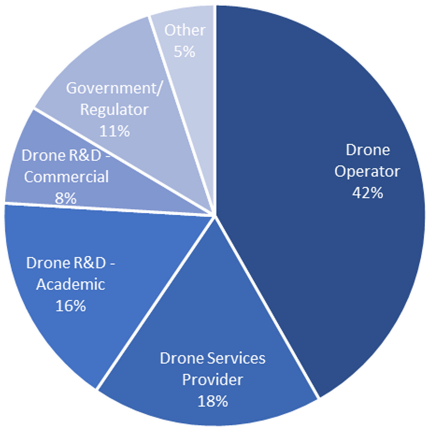
2.1. Participant Recruitment

A workshop format was used for the research. Workshop participants were recruited from the UK drone industry via the research team’s wide network of relevant personal contacts, and also via the membership of the not-for-profit trade association for the UK drone industry (Association of Remotely Piloted Aircraft Systems UK; ARPAS-UK). Email invitations were sent to potential participants, generating around 80 workshop attendees. The workshop was conducted online using a virtual meeting software application (Zoom) due to COVID-19 restrictions, which facilitated attendance by participants from a wide geographic area and achieved a diverse delegate list (Figure 1).

2.2. Workshop Format

The workshop lasted two hours (including a short break) and began with a brief (20 min) presentation by the research team that described the current system for drone access to airspace (i.e., TDAs) and introduced the potential for unsegregated shared airspace (i.e., the Class Lima concept). An independent facilitator chaired the workshop, which took place in August 2021. The chat sidebar in the virtual meeting software application was open continuously throughout the workshop for participants to type comments. After the presentations, the facilitator asked the research team to respond to questions and comments posted in the chat sidebar. In addition, several participants spoke about their experiences.
Participants were also asked to post comments using ‘Post-it’ notes on eight virtual whiteboards with headings as follows: (1) What are the positive features of the Class Lima concept for your use of airspace? (2) How might the Class Lima concept impact on your airspace activities? (3) Do you see any potential issues with the Class Lima concept? (4) What are your views on the widespread use of Electronic Conspicuity? (5) What benefits would you expect to see within an Electronic Conspicuity environment? (6) How should the drone industry ensure that the wider aviation community buys-in to the concept of sharing unsegregated airspace with drones? (7) Are there any wider challenges to shared airspace worth mentioning? and (8) What are the priorities for future research on drones in shared airspace?
In general, the workshop was designed to be as interactive as possible, employing multiple information-gathering channels (verbal transcript, chat sidebar, virtual whiteboards). This interactive approach was adopted to engender a sense of joint ownership of the issues identified, representing an opportunity for the drone industry to be involved in co-developing a suitable way forward.

2.3. Analysis

A thematic analysis approach was used to qualitatively analyse the participants’ comments, both verbal (transcribed) and written, and produce a summary of the attitudes of the drone industry to the integration of drones with crewed aircraft in shared airspace. Thematic analysis was selected as an appropriate approach because it is suitable for identifying and reporting patterns and themes in qualitative data [25,26,27]. The analysis process involved carefully reviewing all comments from participants to identify and code meaningful units of text according to topic. Then, units of text on the same topic were collated to produce topic-specific summaries [27,28].
For example, units of text that mentioned aspects such as detect-and-avoid, electronic conspicuity, electro-optical sensors, or VHF-Out (Section 3.2.1) were all related to the topic of in-flight de-confliction systems, and coded and assigned accordingly; units of text that mentioned airspace infringements or interlopers (Section 3.2.2) were coded and assigned to the topic of airspace infringement; those that mentioned aspects of the process of developing Class Lima (Section 3.2.3) were coded and assigned to the topic of Class Lima concept development. Units of text were coded by the member of the research team possessing suitable subject matter expertise, which meant that there was no opportunity to test any inter-rater variability.
Once realised, the topics were grouped conveniently under predominant themes (Figure 2). For example, the three topics of (i) in-flight de-confliction systems; (ii) airspace infringement; and (iii) Class Lima concept development all relate to the environment in which drone operations take place, and as such were grouped together as the operational environment theme in Figure 2. The three predominant themes were closely linked to the data because an inductive (i.e., data-driven) approach was used for coding, rather than a theoretical approach where the data are coded according to a pre-existing theoretical framework or analytic preconception [25,27].

3. Results and Discussion

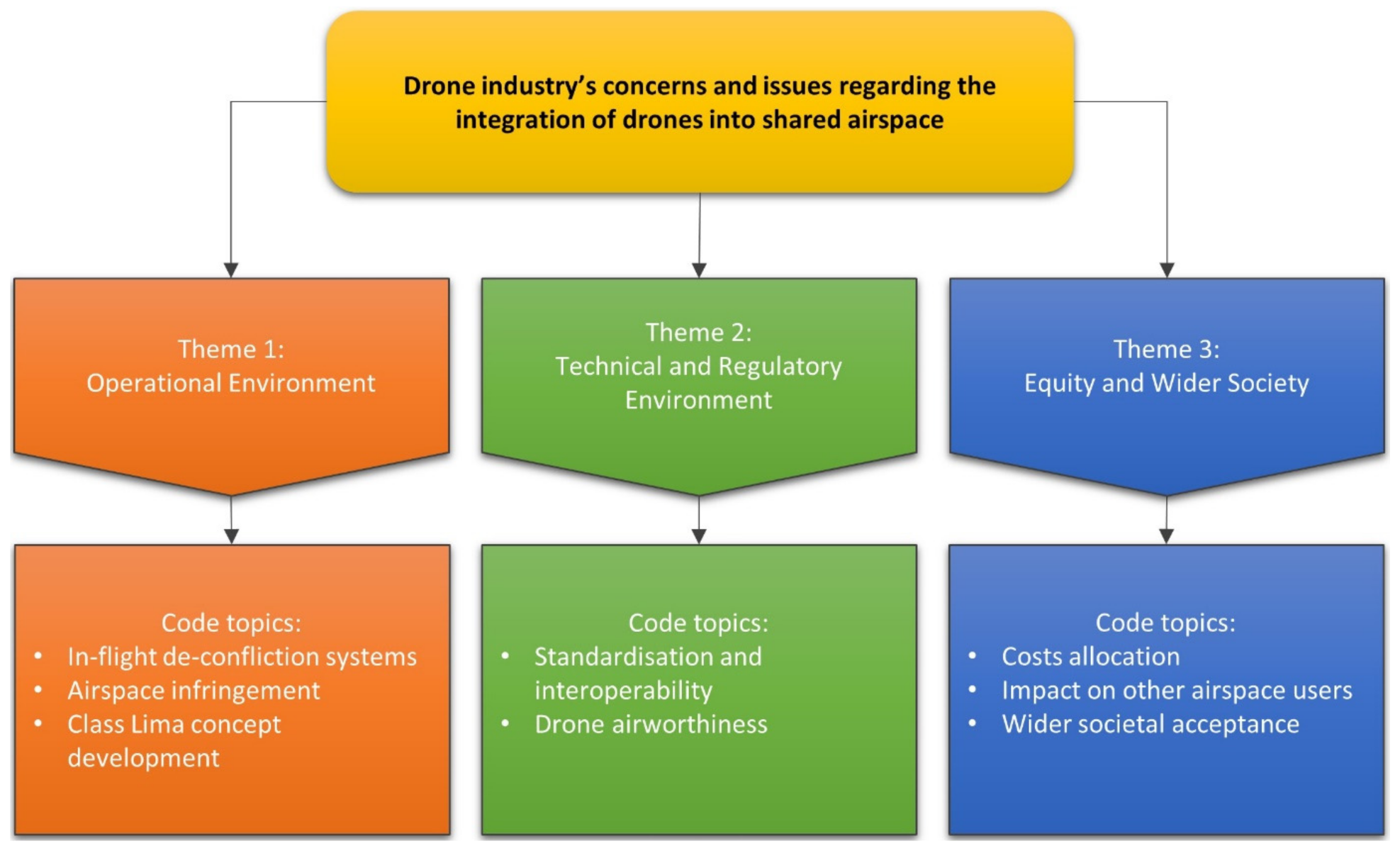
3.1. Code Topics and Predominant Themes

There were ~300 participants’ comments recorded during the two-hour workshop. The relationships between the code topics identified during the thematic analysis and the predominant themes into which they were grouped are shown in Figure 2. Discussion summaries of the participants’ concerns and issues for each topic are provided in subsequent sections, grouped according to their associated over-arching themes. In addition, selected examples of the participants’ comments were tabulated according to topic for all three themes, although it should be noted that some comments were relevant to multiple topics.

3.2. Theme 1: Operational Environment

3.2.1. In-Flight De-Confliction Systems

Participants were in broad agreement that some form of Detect-and-Avoid (DAA) system based on aircraft carrying electronic conspicuity (EC) equipment to enable collision avoidance was essential for the safe integration of drones and crewed aircraft in shared airspace, where EC is an umbrella term to describe devices that allow airspace users to detect each other electronically. Whilst many different EC technologies exist, the option supported by a considerable number of participants was automatic dependent surveillance-broadcast (ADS-B), which is a system whereby an onboard device broadcasts information such as aircraft position, identification, altitude, and velocity.
ADS-B has a strong position as the foremost technology for EC because it is the option favoured by the Federal Aviation Administration (FAA, the NAA in the USA), as evidenced by the recent (2020) adoption of regulations mandating the carriage of ADS-B devices in most controlled airspace within the USA. The USA is also implementing traffic information service-broadcast (TIS-B), which uses ADS-B data to display—in the cockpit of crewed aircraft—a plan view of other traffic in the vicinity of the aircraft (i.e., similar to the traffic collision avoidance system display based on SSR Mode-S transponder data routinely fitted to commercial airliners). However, there were some concerns among participants about the long-term viability of ADS-B due to frequency spectrum congestion. The ADS-B system in the USA uses a dual link interface based on frequencies of 978 and 1090 MHz. One participant who was an EC equipment manufacturer suggested frequency congestion was not a significant issue because the approach used in the USA can be followed to resolve this.
Participants raised electro-optical (EO) sensors fitted to drones to enable automatic collision avoidance as a potential alternative method for DAA. However, this appeared to be regarded as unsuitable by many participants, with one drone operator reporting that they were disappointed with their EO system after trials. This is because EO sensors suffer from similar problems to the See-and-Avoid (SAA) method of collision avoidance routinely performed by pilots of crewed aircraft actively searching for conflicting traffic, with human visual detection performance found to be an unacceptable basis for DAA systems, particularly in relation to detecting small aircraft such as drones with sufficient time remaining to complete avoiding action [29].
Included also within the discussion of EO sensors, mention was made by participants of first-person view (FPV) cameras that relay live video from drones to remote screens or goggles. However, many participants strongly suggested that this was not a reliable method for collision avoidance, most likely because of the same concerns regarding human visual detection performance as described previously in relation to EO sensors. In general, it appears that the development of DAA systems for drones represents an opportunity to improve upon the performance of the human eyeball, rather than reverting to a reimplementation of it as represented by EO sensors or FPV cameras.
VHF-Out is a system involving drones broadcasting continual, automated position reports over a VHF audio frequency to enhance situational awareness of potential conflicting traffic. Participants had concerns about the use of such a system, particularly that the requirement to monitor another frequency would add to pilot workloads and require aircraft to be equipped with at least two VHF radio receivers, and that pilots would not be able to parse the sheer amount of information being received.

3.2.2. Airspace Infringement

Participants discussed the prospect of airspace infringements involving unauthorised entry (either intentional or inadvertent) to designated shared airspace zones by interloping aircraft, for example, aircraft operating within shared airspace when they are not appropriately equipped with EC devices or experiencing EC equipment failure. Many protocols, procedures, and regulations aimed at minimising the possibility of airspace infringements are in place. The CAP 1404 document, published by the UK CAA [30] and referred to in some participants’ comments, details the process for investigating the reported infringements and implementing any remedial measures deemed necessary to prevent recurrence. Despite this, minimising the risk of collisions with interlopers was still viewed as a challenge by participants. In circumstances where an interloper is not appropriately equipped with EC (i.e., an uncooperative target), EO sensors offer an advantage over EC devices because they are absolute sensors that do not rely on other aircraft being suitably equipped to achieve collision avoidance.

3.2.3. Class Lima Concept Development

Many comments from participants related to development pathways for the Class Lima shared airspace concept. It was suggested that there was a need to quantify and compare the risks associated with the different approaches to the use of airspace by drones (i.e., to compare TDA, Class Lima, and UTM solutions in terms of associated risks). Some participants suggested Class Lima may involve less risk than TDAs because TDAs are temporary, and pilots are therefore more likely to be unaware of their existence, leading to increased risk of inadvertent airspace infringements compared to the more permanent Class Lima with which pilots would become familiar. Other participants expressed a contrasting view, suggesting the more permanent nature of Class Lima would increase exposure to infringements compared to the time limited TDAs (i.e., more time in which infringements could occur for Class Lima).
Some participants suggested zones of Class Lima airspace should be restricted to relatively low levels (i.e., below 1000 ft above ground level; AGL). However, this seems to negate the main purpose of Class Lima, which is to open-up airspace by allowing drones and crewed aircraft to operate alongside each other with as much freedom as possible, rather than to quasi-segregate drones by restricting operations to below 1000 ft AGL. It was also suggested was that Class Lima should have a defined maximum traffic density limit above which a UTM shared airspace solution would instead be more appropriate. This suggestion aligns with the intentions for Class Lima, in that it is intended for use in low traffic density regions (Section 1.3).
Participants raised the possibility that Class Lima could be developed and tested in countries with more permissible airspace rules and structures, before being imported into countries with busier, more complex airspace environments such as the UK. This may not be feasible in the timeframe available because the need for a shared airspace solution in countries with busy/complex airspace (such as the UK) is increasingly urgent and full roll-out of UTM is still some years away (Section 1.1). Examples of participants’ comments related to topics in Theme 1 are shown in Table 2.

3.3. Theme 2: Technical and Regulatory Environment

3.3.1. Standardisation and Interoperability

Standardisation and interoperability were raised by participants as issues, especially in relation to EC equipment. There are many different EC technologies on the market, and it was seen as important for regulators to adopt a standardised format enabling interoperability of devices. The current front runner for adoption appears to be ADS-B (Section 3.2.1). Many participants also supported mandating by regulators of the carriage of EC equipment as a prerequisite for entry to shared airspace, but this would require convergence on a common standardised format first and could take a considerable amount of time to enact.
Participants identified that specifying the required minimum equipment to enter shared airspace will be necessary at some point prior to roll-out. It was suggested that this should be a binary specification, involving clear compliance criteria laid-out by regulators, rather than optional equipment that is a “nice to have”. In general, however, it was acknowledged that it will be challenging for all stakeholders (i.e., the wider aviation community) to agree on all the standards necessary for the implementation of shared airspace, such as standards for equipment carriage, drone airworthiness, and operational procedures.

3.3.2. Drone Airworthiness

The conventional aerospace design principle of failover for aircraft systems, whereby functionality is recovered through redundancy, was discussed by participants, in particular in relation to in-flight de-confliction systems. There was agreement that failover systems were required to prevent EC equipment being a single point of failure for DAA, and it was suggested that, whilst they may not be robust systems in isolation, both EO sensors and/or VHF-Out could serve as back-up systems for DAA. For example, if EC equipment were to fail, a pilot could tune a published VHF-Out frequency to receive drone position reports, mitigating the risk of a collision with a drone.
Some participants suggested that the CAA approval process for drone airworthiness in the UK takes too long, and that the introduction of an experimental category could be an option to accelerate drone development without demanding too much of the CAA’s capacity. There is currently no regime for drone airworthiness certification in the UK, with approvals granted on a case-specific basis instead [4]. Introduction of such a regime (as is the case for type certification of crewed aircraft) may be a way to hasten the process but is likely to involve a considerable up-front investment of time and effort on behalf of the CAA to establish. Examples of participants’ comments related to topics in Theme 2 are shown in Table 3.

3.4. Theme 3: Equity and Wider Society

3.4.1. Costs Allocation

During the discussions, there was very little suggestion of a resistance to paying the costs involved with equipping drones to operate in shared airspace, principally the costs of installing any EC equipment required, indicating that this is not seen as an issue for drone operators. This could be because the drone operators are commercial companies more willing to offset the expense against potential revenue generation, in contrast to individuals using airspace for sport and leisure purposes who may be more resistant to spending personal money.
In fact, several participants went beyond consideration of their own costs and suggested that the drone industry should bear part/all of the costs incurred by all the parties intending to use shared airspace. In other words, the drone industry should fund any changes necessitated by the introduction of shared airspace including providing the required equipment for all airspace users.

3.4.2. Impact on Other Airspace Users

There appeared to be an understanding among participants of the need to ensure that the shared airspace concept was supported by the wider aviation community and that access to airspace was equitable for all. In particular, the sports and leisure flying community (referred to as general aviation (GA) in this paper) was identified as an important stakeholder (e.g., private light aeroplanes and helicopters, gliders, microlights, hang gliders, paragliders, paramotors, hot air balloons, model aircraft flyers, etc.). This is because drone operations predominantly take place in uncontrolled airspace, of which GA is an extensive user, and if areas of uncontrolled airspace are to be designated as shared airspace zones, GA airspace users are likely to be significantly impacted. Participants suggested that the wider aviation community should be engaged in the co-development and design of the shared airspace concept from the very start, and that the potential benefits for all airspace users (e.g., safer skies for all) should be stressed.
One barrier to widespread support identified by participants was the requirement to fit EC equipment in order to access shared airspace. This was seen as likely to meet opposition from some within the GA community, most often for reasons regarding the costs involved. Whilst not specifically mentioned by the participants, a related issue that can be reasonably foreseen is that if regulators do mandate a common standardised format for EC equipment (as suggested by participants in Section 3.3.1), there is likely to be considerable pushback from airspace users already committed to alternative EC formats or to not carrying EC at all.

3.4.3. Wider Societal Acceptance

The issue of gaining wider societal acceptance for the shared airspace concept was raised by the participants. It was suggested that it was important to demonstrate to the public that the shared airspace concept is low risk in the case of both ground and air risks, and that this should be carried out through a quantified assessment of the risks involved. Alongside this, it was suggested that the potential of drone operations facilitated by the introduction of shared airspace to deliver considerable benefits to society should be emphasised, in particular to focus on especially beneficial use cases such as health care logistics, for example, the National Health Service (NHS) logistics in the UK. Examples of participants’ comments related to topics in Theme 3 are shown in Table 4.

3.5. Numbers of Endorsing Comments from Participants

The numbers of comments from participants endorsing the outcome and/or criticality of the different issues associated with each topic were collated, with results shown in Table 5. Whilst prevalence of mentions by participants is not necessarily directly correlated with topic importance [27], the numbers of comments shown in Table 5. can be used as a quantitative guide, indicating the relative importance to the workshop participants of the issues associated with each topic. Results suggested that the most important issues were (i) the necessity for a dependable DAA system for in-flight de-confliction in shared airspace, based on mandated carriage of onboard EC devices and failover system capabilities, and (ii) the importance of support for the development and implementation of a shared airspace concept from the wider aviation community.

4. Conclusions

The many and diverse issues and opinions of the drone industry related to the concept of integrating drone operations into unsegregated shared airspace have been captured by the workshop, serving as an example of good practice for stakeholder involvement. The outcomes were classified through qualitative thematic analysis into three over-arching themes: (1) operational environment; (2) technical and regulatory environment; and (3) equity and wider society. Having identified the issues, the challenge now is to maintain the involvement of the drone industry (and all other stakeholders) in resolving these issues during the co-development and implementation of a shared airspace solution that allows equitable access for all airspace users. In particular, maintaining involvement in the subsequent development of the Class Lima concept (now called Project Lima) that the authors see as being necessary in the short-term to meet the pressing need for a shared airspace solution due to the current expansion of drone operations in advance of UTM readiness, and in the long-term as a more versatile, less burdensome approach than UTM for low traffic density regions. As one initiative to ensure continued involvement of the drone industry, an open invitation for participation in future research has been extended to all workshop participants.
The problem of how best to integrate drones into shared airspace alongside crewed aircraft is being discussed internationally, and is being addressed in many regions around the world through the development of the UTM concept, for example, in the UK, the USA, Europe (known as U-Space), and China (known as UAV Operation and Management; UOM) [31]. UTM has the advantage of being a globally recognised concept, whereas awareness of Class Lima would need to be raised outside the UK, if it is to become an international solution. Implementing shared airspace solutions on a national rather than international basis is likely to increase the risk of creating a future situation composed of a patchwork of country-specific regulations and procedures that could impede the operation of a drone industry that is multi-national in nature, potentially involving cross-border international transport routes.
In summary, from an airspace management policy perspective, the implication of the research is that equitable technological and regulatory environments relating to the unsegregated operation of both drones and crewed aircraft within shared airspace need to be developed and established, which is what the Class Lima concept aims to achieve within a useful timeframe. The study has highlighted the importance of engaging a diverse set of actual airspace users in this process, which represents a step forward compared to other innovations that tend to focus on specific use cases rather than interactions with other users and/or uses of the same space. From the perspective of future research, there is an urgent need to begin real-world test flights to understand how the unsegregated interaction of drones and crewed aircraft might best be achieved in practice. Progress of Class Lima towards real-world implementation has been given a significant impetus recently by a successful application to join the UK CAA’s Innovation Sandbox, a programme aimed at trialling innovative solutions that may not fit within the scope of existing regulations under real-world conditions in partnership with the CAA.

Author Contributions

Conceptualization, M.G., A.P., J.S., T.C., J.D., A.S. and A.O.; Methodology, M.G., A.P., J.S., T.C., J.D., A.S. and A.O.; Formal analysis, M.G. and A.P.; Investigation, M.G., A.P., J.S., T.C., J.D., A.S. and A.O.; Writing—original draft preparation, M.G. and J.S.; Writing—review and editing, M.G., A.P., J.S., T.C., J.D., A.S., A.O. and G.M.; Supervision, T.C.; Project administration, M.G. and T.C.; Funding acquisition, T.C. All authors have read and agreed to the published version of the manuscript.

Funding

This research was funded by EPSRC grant number EP/V002619/1.

Institutional Review Board Statement

The study was conducted according to the guidelines of the Declaration of Helsinki, and approved by the Ethics Committee of Bournemouth University (Ethics ID number 36336, 1st March 2021).

Informed Consent Statement

Informed consent was obtained from all subjects involved in the study.

Data Availability Statement

The data used in this study are not publicly available due to the conditions of the ethics approval for the study. Contact the corresponding author for further information.

Acknowledgments

Not applicable for this study.

Conflicts of Interest

The authors declare no conflict of interest.

References

  1. Rana, K.; Praharaj, S.; Nanda, T. Unmanned Aerial Vehicles (UAVs): An Emerging Technology for Logistics. Int. J. Bus. Manag. Invent. 2016, 5, 86–92. [Google Scholar]
  2. Scott, J.E.; Scott, C.H. Drone Delivery Models for Healthcare. In Proceedings of the 50th Hawaii International Conference on System Sciences (HICSS), Waikoloa, HI, USA, 4–7 January 2017. [Google Scholar]
  3. Darvishpoor, S.; Roshanian, J.; Raissi, A.; Hassanalian, M. Configurations, flight mechanisms, and applications of unmanned aerial systems: A review. Prog. Aerosp. Sci. 2020, 121, 100694. [Google Scholar] [CrossRef]
  4. Grote, M.; Cherrett, T.; Oakey, A.; Royall, P.G.; Whalley, S.; Dickinson, J. How Do Dangerous Goods Regulations Apply to Uncrewed Aerial Vehicles Transporting Medical Cargos? Drones 2021, 5, 38. [Google Scholar] [CrossRef]
  5. Lin, C.A.; Shah, K.; Mauntel, L.C.C.; Shah, S.A. Drone delivery of medications: Review of the landscape and legal considerations. Am. J. Health Syst. Pharm. 2018, 75, 153–158. [Google Scholar] [CrossRef] [PubMed]
  6. Goodchild, A.; Toy, J. Delivery by drone: An evaluation of unmanned aerial vehicle technology in reducing CO2 emissions in the delivery service industry. Transp. Res. Part D Transp. Environ. 2018, 61, 58–67. [Google Scholar] [CrossRef]
  7. Aurambout, J.-P.; Gkoumas, K.; Ciuffo, B. Last mile delivery by drones: An estimation of viable market potential and access to citizens across European cities. Eur. Transp. Res. Rev. 2019, 11, 30. [Google Scholar] [CrossRef] [Green Version]
  8. Sah, B.; Gupta, R.; Bani-Hani, D. Analysis of barriers to implement drone logistics. Int. J. Logist. Res. Appl. 2020, 24, 1–20. [Google Scholar] [CrossRef]
  9. Alarcón, V.; García, M.; Alarcón, F.; Viguria, A.; Martínez, Á.; Janisch, D.; Acevedo, J.J.; Maza, I.; Ollero, A. Procedures for the Integration of Drones into the Airspace Based on U-Space Services. Aerospace 2020, 7, 128. [Google Scholar] [CrossRef]
  10. Hatfield, M.; Cahill, C.; Webley, P.; Garron, J.; Beltran, R. Integration of Unmanned Aircraft Systems into the National Airspace System-Efforts by the University of Alaska to Support the FAA/NASA UAS Traffic Management Program. Remote Sens. 2020, 12, 3112. [Google Scholar] [CrossRef]
  11. Merkert, R.; Bushell, J. Managing the drone revolution: A systematic literature review into the current use of airborne drones and future strategic directions for their effective control. J. Air. Transp. Manag. 2020, 89, 101929. [Google Scholar] [CrossRef] [PubMed]
  12. Capitán, C.; Pérez-León, H.; Capitán, J.; Castaño, Á.; Ollero, A. Unmanned Aerial Traffic Management System Architecture for U-Space In-Flight Services. Appl. Sci. 2021, 11, 3995. [Google Scholar] [CrossRef]
  13. Jelev, N. European Network of U-Space Demonstrators—Lessons Learned from the Isles of Scilly (UK) BVLOS Airbridge; Eurocontrol: Brussels, Belgium, 2021. [Google Scholar]
  14. Civil Aviation Authority (CAA). Unmanned Aircraft System Operations in UK Airspace—Guidance (CAP 722); Civil Aviation Authority: Crawley, UK, 2020. [Google Scholar]
  15. International Civil Aviation Organization (ICAO). Annex 11 to the Convention on International Civil Aviation—Air Traffic Services, 15th ed.; International Civil Aviation Organization: Montreal, QC, Canada, 2018. [Google Scholar]
  16. NATS. Introduction to Airspace. Available online: https://www.nats.aero/ae-home/introduction-to-airspace/ (accessed on 19 May 2021).
  17. International Civil Aviation Organization (ICAO). Unmanned Aircraft Systems Traffic Management (UTM)—A Common Framework with Core Principles for Global Harmonization; International Civil Aviation Organization: Montreal, QC, Canada, 2020. [Google Scholar]
  18. Civil Aviation Authority (CAA). A Unified Approach to the Introduction of UAS Traffic Management (CAP 1868); Civil Aviation Authority: Crawley, UK, 2019. [Google Scholar]
  19. McCarthy, T.; Pforte, L.; Burke, R. Fundamental Elements of an Urban UTM. Aerospace 2020, 7, 85. [Google Scholar] [CrossRef]
  20. Guan, X.; Lyu, R.; Shi, H.; Chen, J. A survey of safety separation management and collision avoidance approaches of civil UAS operating in integration national airspace system. Chin. J. Aeronaut. 2020, 33, 2851–2863. [Google Scholar] [CrossRef]
  21. Barrado, C.; Boyero, M.; Brucculeri, L.; Ferrara, G.; Hately, A.; Hullah, P.; Martin-Marrero, D.; Pastor, E.; Rushton, A.P.; Volkert, A. U-Space Concept of Operations: A Key Enabler for Opening Airspace to Emerging Low-Altitude Operations. Aerospace 2020, 7, 24. [Google Scholar] [CrossRef] [Green Version]
  22. Liu, Z.; Cai, K.; Zhu, Y. Civil unmanned aircraft system operation in national airspace: A survey from Air Navigation Service Provider perspective. Chin. J. Aeronaut. 2021, 34, 200–224. [Google Scholar] [CrossRef]
  23. Civil Aviation Authority (CAA). Radio and Transponder Mandatory Zones—Consultation on Revised SARG Airspace Policy Statement; Civil Aviation Authority: Crawley, UK, 2020. [Google Scholar]
  24. SkyDemon. Welcome to SkyDemon. Available online: https://www.skydemon.aero/ (accessed on 15 July 2021).
  25. Braun, V.; Clarke, V. Using thematic analysis in psychology. Qual. Res. Psychol. 2006, 3, 77–101. [Google Scholar] [CrossRef] [Green Version]
  26. Fereday, J.; Muir-Cochrane, E. Demonstrating Rigor Using Thematic Analysis: A Hybrid Approach of Inductive and Deductive Coding and Theme Development. Int. J. Qual. Methods 2006, 5, 80–92. [Google Scholar] [CrossRef]
  27. Grote, M.; Waterson, B.; Rudolph, F. The impact of strategic transport policies on future urban traffic management systems. Transp. Policy 2021, 110, 402–414. [Google Scholar] [CrossRef]
  28. Frith, H.; Gleeson, K. Clothing and Embodiment: Men Managing Body Image and Appearance. Psychol. Men Masculinities 2004, 5, 40–48. [Google Scholar] [CrossRef]
  29. Clothier, R.A.; Williams, B.P.; Cox, K.; Hegarty-Cremer, S. Human See and Avoid Performance and its Suitability as a Basis for Requirements for UAS Detect and Avoid Systems. In Proceedings of the 17th AIAA Aviation Technology, Integration, and Operations Conference, Denver, CO, USA, 5–9 June 2017. [Google Scholar]
  30. Civil Aviation Authority (CAA). Airspace Infringements: Review and actions Process (CAP 1404); Civil Aviation Authority: Crawley, UK, 2021. [Google Scholar]
  31. Xu, C.; Liao, X.; Tan, J.; Ye, H.; Lu, H. Recent Research Progress of Unmanned Aerial Vehicle Regulation Policies and Technologies in Urban Low Altitude. IEEE Access 2020, 8, 74175–74194. [Google Scholar] [CrossRef]
Figure 1. Breakdown of workshop participants by interest group. ‘Drone Services Provider’ includes consultancy, training, UTM, and airfield/navigation services. ‘Other’ includes drone industry bodies/associations, drone equipment manufacturers, and hobbyists.
Drones 05 00150 g001
Figure 2. Diagram of code topics and over-arching themes.
Drones 05 00150 g002
Table 1. Features of the Class Lima shared airspace concept.
Feature
Designated zone in appropriate locations (i.e., low population and air traffic densities).
Guaranteed Secondary Surveillance Radar (SSR) transponder 1 reception coverage within the zone (although carriage of a SSR transponder is not a Class Lima entry requirement).
Low latency and free promulgation of drone flight plans, along with ‘live’ drone traffic status updates. These would be accessible to all airspace users via various connected apps such as SkyDemon [24] or similar.
Assurance that drone operators would track crewed traffic within the zone to ensure separation was maintained.
Requirement for drones to be capable of automatically avoiding any other electronic conspicuity (EC) sources in the zone, where EC is an umbrella term for devices fitted to aircraft that allow airspace users to be detected electronically. This provides an additional safety layer should drone command links fail.
No additional costs and/or complex procedures involved for crewed air traffic, except for the costs associated with fitting EC equipment, with some NAAs even offering financial incentives to encourage EC uptake (e.g., the UK Civil Aviation Authority (CAA) is currently offering a 50% rebate, up to a maximum of £250, on the cost of EC equipment).
Drones operating within the zone would be capable of automatically broadcasting regular position reports on a designated VHF frequency (VHF-Out). This would provide a further safety level, enabling crewed aircraft to maintain situational awareness that allows intervention should primary separation systems fail.
No requirement for an air navigation service provider (ANSP) because this would be unnecessary, costly, and technically challenging in remote regions.
1 SSR transponders are traditional aviation transponders responsive to interrogation by the SSR system utilised by ATC worldwide.
Table 2. Examples of the participants’ comments relating to topics in Theme 1.
Participants’ Comments
3.2.1. In-Flight De-Confliction Systems:
  • “EC is a great idea and, of course, will be mandated.”
  • “A key part of BVLOS will be Detect-And-Avoid—[for example] the paramotor is protecting himself by transmitting ADS-B on 1090 MHz, the drone…will detect the paramotor and algorithms can ensure it avoids. Mandatory EC for drones is a key part of BVLOS.”
  • “EC based detection does not have the uncertainty of vision-based/sound-based detection.”
  • “We’re already working with drone manufacturers to build ADS-B conspicuity into their devices. We currently put it into separate boxes, which have to be carried, we can make them very, very small, but you still have to integrate it onto your drone.”
  • “Can ADS-B be scaled up given the potential number of airborne drones in the future (lots of messages!)? Agree it’s a great EC technology.”
  • “Spectrum congestion on 1090 MHz can be overcome by putting drone EC onto 978 MHz and utilising TIS-B to rebroadcast between the two networks (as in USA).”
  • “We’re already looking at using 978 MHz [for ADS-B] in the UK and the trials we’re doing right now are using 978 MHz on the drones to Detect-And-Avoid and we cross fertilize between 1090 MHz and 978 MHz, and…that’s been successful in the States.”
  • “Collision avoidance detection is strongly biased to electronic conspicuity, is there no room for vision- and audio-based systems?”
  • “EO works just fine at low level in certain ways, filtering out false positives is of course a challenge, but we have made great in-roads with this recently and it is better than not having it.”
  • “Not suggesting a specific EO is mandated. I am suggesting a responsible operator will want to fit one for the last-ditch collision avoidance manoeuvre.”
  • “There would need to be some form of electrical-optical last-ditch collision avoidance.”
  • “[Commercial drone operator] integrated an EO camera last summer, and we were kind of disappointed with the overall performance.”
  • “What concerns me…is that we would get significant false positives out of EO.”
  • “I haven’t seen an EO that would meet my specification yet.”
  • “At low operating altitudes, EO is not a robust solution.”
  • “We will happily fit them [EO sensors] when they are cheap enough and good enough. Currently, this is not a ‘solved problem’. I agree entirely they might be a useful last-ditch safety feature.”
  • “We are strongly against mandating EO-based detection systems. EC works today—no research needed, just engineering. Not against adding a working EO system in the future which adds safety, but not required in our view for this initiative [Class Lima] where the ‘zone’ is clearly defined, and GA [General Aviation] pilots will know they are required to have an EC device.”
  • “You’ve got the Mark 1 Eyeball, but you’ve also got to remember that it’s been proven that the Mark 1 Eyeball is only good 39–51% of the time, and if you look at the UK Airprox Board’s annual summary, you’ll see the amount of near misses that happened because the Mark 1 Eyeball didn’t work for the majority of the time.”
  • “I personally am terrified of the idea that drones would actually be flown manually and that FPV cameras would be used for de-confliction.”
  • “I do agree with you, it’s worthwhile trialling [VHF-Out].”
  • “I don’t honestly see a single VHF position reporting frequency [VHF-Out] is viable. Unless aircraft have two radios, they are unlikely to be on the frequency as working other units. It’s likely to be beyond the ability of some GA pilots to take in the information as it will task-saturate them.”
  • “That kind of new information [VHF-Out] you just can’t take it in and, with the best will in the world, there are pilots out there who cannot take it in, and frankly it’s just going to overload them.”
  • “Position reports [VHF-Out] are perfectly fine when flying over places such as Africa with a lack of communications to listen to with ATC. Around the UK, with GA aircraft sometimes only having one radio, they will not give up flight information with a basic traffic service to listen-out to drone position reports.”
3.2.2. Airspace Infringement:
  • “We need to look at the risk of those that potentially are not [EC] equipped or equipment failure.”
  • “It’s not quite good enough to hang on to CAP 1404 [because] a rule doesn’t mean people don’t break it, whether inadvertently or intentionally, responsible operators will have to have some form of collision avoidance.”
  • “Interlopers will be there, the fact that there’s a CAP [CAP 1404] to say that they shouldn’t be/isn’t going to be a good enough mitigator if we do ‘swap paint’ with an interloper.”
  • “We will always have interlopers…so, to say that EC is the only solution might not be capturing all of the risks. So, I wouldn’t say that an electro-optical system should be mandated, but responsible operators should perhaps consider the fitment of an electro-optical last-ditch collision avoidance system.”
  • “EC just one part of the collision avoidance picture, looks like a lot of reliance on EC for Class Lima, does not cope with interlopers. Onboard self-generated collision avoidance is needed, [such as] EO sensors.”
3.2.3. Class Lima Concept Development:
  • “I think there is a need to clarify the reduction in risk that Class Lima will bring compared with where we are now and where we will be in the future with full UTM, etc.”
  • “There is no completely safe interim step to full UTM. An acceptance of less safety (higher risk) to either the public or other airspace users (including other drones) is the only way forward.”
  • “I’d say that a TDA is more likely to be infringed due to people not expecting it…[Class Lima] can be permanent so risk is lower from a human factors perspective.”
  • “[Class Lima] could actually reduce [risk of infringements] because people are becoming habitualised to the fact that the airspace is that way now.”
  • “[Class Lima] can be a permanent change to the airspace, thus less confusing for airspace users.”
  • “The amount of exposure we suddenly then have to interlopers is presumably greater [for Class Lima] than a time limited TDA.”
  • “Why can’t [Class Lima] just be up to 500 ft or 1000 ft AGL? Takes up a lot less airspace for GA and makes the brick wall in the sky…more of a speed bump for them.”
  • “We may stray into UTM if the density of traffic gets beyond X, we have to collectively decide what X is.”
  • “What happens when traffic density goes up…I think there would have to be an upper threshold where we need more sophisticated solutions.”
  • “How about a dress-rehearsal [of Class Lima] in a country with more permissive rule sets, and when we have operated together there, bring it back [to the UK].”
Table 3. Examples of the participants’ comments relating to topics in Theme 2.
Participants’ Comments
3.3.1. Standardisation and Interoperability:
  • “We’re going to have to write down some compliance criteria for drones operating in that area [shared airspace] and it has to be binary, you either have to, or you don’t. We can’t say well let’s make it a nice option, so I think we’ve got to be clear on what we tell people, and we can’t make it an optional extra.”
  • “I think the writing’s on the wall, I think actually we’re going to have to force airspace users generally to fit EC.”
  • “A government mandate [for EC equipment] and applicable EU/UK standard will be required from a compliance point of view as otherwise there is zero incentive for commercial/retail UAS/drone manufacturers to get involved. The reality is these standards will need to be written into the appropriate legislation.”
  • “No single EC carriage will be perfect, so we have to accept interoperability.”
  • “To mandate the carriage equipage will require regulatory change. This could take a considerable amount of time.”
  • “I agree, ADS-B will be the future.”
  • “Needs to be based on common, standard technology—namely ADS-B.”
  • “The key to having an EC system that can be used reliably for de-confliction is to make it mandatory for all—drones included. Ideally the technology should be uniform—ADS-B is reliably used for this purpose in USA.”
  • “What will make it work is a government mandate for, in my opinion, ADS-B, that is the technology of the future. There are parties around that want to make it EC system agnostic, I don’t think you can, it needs to be a single technology, and I think that technology is ADS-B.”
  • “It is going to be challenging to get all stakeholders to agree on standards such as airworthiness, EC, and operations.”
3.3.2. Drone Airworthiness:
  • “A blend of all is required, EC and EO.”
  • “There is no one [DAA] solution that’s going to be 100%...we layer up the defences, the more we’ve got, the less chance of an accident getting through.”
  • “You cannot rely on EC or EO in isolation, so a blend is required.”
  • “A final last-ditch collision avoidance manoeuvre through an electro-optical sensor is perhaps what responsible operators should fit.”
  • “Having an FPV camera while flying BVLOS, or using an EO based collision avoidance system, whilst not reliable, it would provide a form of mitigation in the case of non-compliance or EC failure.”
  • The process for [drone] airworthiness takes too long, and an aircraft will be obsolete before getting an approval. CAA has to speed up.”
  • “The need for an experimental category [for drones] to accelerate development without soaking up CAA bandwidth.”
Table 4. Examples of the participants’ comments relating to topics in Theme 3.
Participants’ Comments
3.4.1. Costs Allocation:
  • “[The drone industry should] fund any changes.”
  • “GA sometimes get a little bit frustrated even having to put a radio on board their aircraft, let alone any other additional equipment, because it all comes down to a cost.”
  • “[The drone industry should] contribute to an equipage fund.”
  • “[A requirement to carry an EC] transponder at a cost of a couple of thousand pounds, that is what will get the GA community aggravated.”
  • “It’s those kinds of rebates [CAA EC equipment 50% rebate] that will make the difference to get the GA community to spend a small amount of money that makes them conspicuous.”
3.4.2. Impact on Other Airspace Users:
  • Ultimately, we’re providing a restriction on them [the GA community] flying where they want to, when they want to… and it’s restricting their freedom of access to air space.”
  • “I think that it’s the only way to bring the GA community onboard, you’ve got to get rid of the TDAs as everybody has to be able to operate together, Detect-and-Avoid is all part of that.”
  • “Support from the aviation community in general [will be a potential issue].”
  • “Bring them [the wider aviation community] in from the get-go, and not just within the consultation exercise, they should be a part of the design.”
  • “Start implementing a just culture and shared lessons learnt platform from the outset, showing their [the wider aviation community’s] concerns are shared and addressed pro-actively.”
  • “Engage airspace users to solve some of these issues [associated with shared airspace].”
  • “Engagement to stress benefits to all.”
  • “Show that it can make the skies safer for the GA community as well, create jobs in the space, show how more money will flow to small regional airports as large UAS come into service improving their [the GA community’s] overall experience as well.”
  • “Mandatory use [of EC] makes the sky safer for everyone.”
  • “Improved safety for all airspace users due to having a better situational awareness of their surrounding airspace [would be a benefit of EC].”
  • “The paraglider and paramotor community often carry less tech…many would not carry devices for monitoring airspace unless perhaps flying cross country. I fly paramotors myself and made the decision to use an ADS-B (especially due to the 50% CAA rebate)…but note the fact that it is currently not compulsory. I also feel that perhaps it should be [compulsory].”
  • “Critical to get government operators onboard (police, med-evac, military).”
3.4.3. Wider Societal Acceptance:
  • “Understanding of what those [shared airspace] risk reductions are, and what that means to everyone using the airspace and the public beneath the airspace, and also how you would go about having that risk reduction accepted and who’s going to accept that, and on behalf of who?”
  • “Prove that the introduction of drones is not making the airspace any less safe.”
  • “When we talk about risk, we don’t know the risks…very rarely do we actually quantify the risk.”
  • “Without data of all air traffic, it’d be difficult to measure the risk. Mandated EC would be key to building-up this map.”
  • “By focusing on the benefits to society and making it clear that the initial stage will be low ground risk and air risk routes with high positive benefit.”
  • “Drones for good use cases, and make the human benefits clear, for example, cancer treatment, blood transfusions, removal of humans from working at height.”
  • “Focus on societally beneficial use cases—NHS-centric is perfect.”
  • “I’d suggest the missing bit is the use case outcome, i.e., benefits to NHS. The only way to apportion the pain [i.e., any necessary sacrifices/compromises] is to understand the gain—[for example,] if GA does X and drone developers do Y, we can turn around 50% more blood tests in 24 h or reduce van emissions by Y%.”
Table 5. Number of participants’ comments endorsing issues associated with each topic.
TopicGeneral Outcome/Criticality of IssuesNumber of Endorsing Comments 1
3.2.1. In-Flight De-Confliction SystemsDAA systems are necessary, based on onboard EC devices.63
ADS-B is the foremost EC technology.17
EO sensors or FPV cameras are suitable in isolation for DAA systems (see ‘Drone Airworthiness’ topic rows for suitability as back-ups).3
VHF-Out is not viable for de-confliction.7
3.2.2. Airspace InfringementMinimising risk of collisions with interlopers is challenging, despite preventative measures.8
3.2.3. Class Lima Concept DevelopmentThere is a need to quantify/compare risks associated with different solutions to the use of airspace by drones.6
Class Lima is lower risk because TDAs are temporary meaning inadvertent infringements are more likely due to lack of awareness.4
Class Lima is higher risk because permanency increases exposure to infringements compared to time limited TDAs.2
Class Lima should be restricted to low level airspace.4
Class Lima should have a defined maximum traffic density limit above which UTM is more appropriate.4
Class Lima should be developed in countries with more permissible airspace rules/structures.4
3.3.1. Standardisation and InteroperabilityRegulators should adopt standardised, interoperable formats, particularly for EC equipment.14
Regulators should mandate the carriage of EC equipment for entry to shared airspace.21
Specification of minimum equipment to enter shared airspace will be required.2
3.3.2. Drone AirworthinessFailover is required for in-flight de-confliction systems.24
EO sensors/FPV cameras/VHF-Out could serve as back-ups for EC-based DAA systems.18
CAA approval process for drone airworthiness takes too long at present.2
3.4.1. Costs AllocationOther airspace users will be resistant to costs incurred due to using shared airspace.8
Drone industry should bear part/all of the costs incurred by all parties intending to use shared airspace.2
3.4.2. Impact on Other Airspace UsersShared airspace needs to be supported by the wider aviation community.24
Requirement to fit EC equipment is a barrier to widespread support for shared airspace.6
3.4.3. Wider Societal AcceptanceDemonstrating to the public that shared airspace is low risk is important.5
Societal benefits of shared airspace enabling drone operations should be emphasised.6
1 Some comments were relevant to multiple topics/issues (Section 3.1) and therefore appeared multiple times in the numbers reported.
Publisher’s Note: MDPI stays neutral with regard to jurisdictional claims in published maps and institutional affiliations.

