Article

Surveys of Large Waterfowl and Their Habitats Using an Unmanned Aerial Vehicle: A Case Study on the Siberian Crane

1
South China Institute of Environmental Science, Ministry of Ecology and Environment, Guangzhou 510530, China
2
CAS Key Laboratory of Forest Ecology and Management, Institute of Applied Ecology, Chinese Academy of Sciences, Shenyang 110036, China
3
Zhongshan Institute, University of Electronic Science and Technology, Zhongshan 528402, China
4
E’erguna Wetland System National Research Station, E’erguna 022250, China
*
Author to whom correspondence should be addressed.
Drones 2021, 5(4), 102; https://doi.org/10.3390/drones5040102
Submission received: 20 July 2021 / Revised: 19 September 2021 / Accepted: 20 September 2021 / Published: 23 September 2021
(This article belongs to the Special Issue Drones for Biodiversity Conservation)

Abstract

:
Waterfowl surveys, especially for endangered waterfowl living in wetlands, are essential to protect endangered waterfowl and to create a management scenario of their habitats. Unmanned aerial vehicles (UAVs) are powerful new tools for waterfowl surveys. In this paper, we propose one method for a habitat survey and another for a waterfowl species distribution survey. The habitat survey method obtained the waterfowl’s habitat and spatial distribution with a UAV automatic flight plan in the aggregation area. The waterfowl species distribution survey was used to detect and identify waterfowl species with high-spatial-resolution images from a free UAV flight plan in the aggregation area or areas where individuals were suspected to be present. The UAV-based data showed not only the area where waterfowl were found, but also additional ground surveys. The results showed that the species and locations of the waterfowl were recorded more accurately and efficiently using the distribution method based on the images from the UAV. The waterfowl habitat type and the number of waterfowl were obtained in detail using the habitat survey method. UAV-derived counts of waterfowl were greater (+37%) than ground counts. The results indicated the feasibility and advantages of using a low-cost UAV survey of large waterfowl in wetland regions with complex vegetation. This study provides one case study of large waterfowl numbers and habitat surveys. The UAV-based methods also provide a feasible and scientific way to obtain basic data for the protection and management of waterfowl.

1. Introduction

Waterfowl play an important role in maintaining the energy flow and stability of wetland ecosystems as an important component of the food chain [1]. In addition, waterfowl are very sensitive to changes in the quality and structure of wetland habitats; to some extent, their distribution and quantity reflect these changes in wetland ecosystems [2]. Surveying the waterfowl’s numbers and habitat in wetlands is not only needed for waterfowl protection but also reveals important indicators for assessing the health of wetlands [3]. Waterfowl surveys, especially the surveying of endangered waterfowl living in wetlands, are of great importance to maintaining the population stability of endangered waterfowl and clarifying the selection mechanism of their habitats. The Siberian crane, Grus leucogeranus, is a typical wetland-dependent representative of endangered waterfowl. According to the International Union for the Conservation of Nature (IUCN) Red List, the Siberian crane population is fewer than 4000, and it is the third most endangered crane in the world [4]. Surveying its population and habitat selection mechanism is essential for maintaining its population stability and managing its habitat. Northeastern China is a stopover site along the Siberian crane’s migration route; the Chinese government has established reserves to ensure the safety of the migration process and surveyed the cranes every year [5,6]. However, due to limited funding and labor, the government staff can only monitor the cranes in limited areas rather than in the entire reserves.
Data about waterfowl habitats and the locations and numbers of individuals and their habitats are indispensable in waterfowl research. Traditional survey methods mainly include field surveys and aerial surveys. At present, field surveys are the main methods used by the management departments in most wetland conservation zones. The field survey requires experienced persons and consumes considerable time and resources. However, the data are not always accurate owing to the subjective judgment of the investigator. The field survey method creates barriers to accurate recording of the geospatial locations and numbers of waterfowl because of the inaccessibility of some wetland areas [7]. While aerial surveys can overcome the limitations of environmental conditions and be better suited to wetland waterfowl surveys, they are not widely applied because of the high price and the need for investigators with special aviation training, especially for long-term monitoring programs [8]. At present, the satellite tracking method is increasingly being applied because it can track the migration routes of waterfowl in real time and obtain precise geographical locations of their habitats [9]. However, because of the high price, environmental factors, and human poaching, only a small number of surveyed samples can provide useful information. Therefore, traditional survey methods can prevent investigators from obtaining accurate information about waterfowl at low cost. This difficulty is exacerbated in species that are inaccessible and species that are susceptible to human disturbances, such as wetland-dependent waterfowl. Thus, it can be challenging to develop efficient new methodologies for obtaining data on easily disturbed or difficult-to-access species.
Siberian crane stopover sites are often in areas with inconvenient transportation or underdeveloped economies. The local reserve management departments generally have problems with insufficient personnel and monitoring equipment. In recent years the development of UAV remote-sensing technology, reliable low price flight platforms, and powerful camera systems has provided new powerful tools for wildlife monitoring [10,11,12]. UAV remote-sensing technology enables low-intensity interference, precise positioning, accurate counting, and close-range observation of wildlife, and it provides first-hand data sources for wildlife protection [13,14]. As of the 21st century, UAVs are increasingly used in the investigation and monitoring of waterfowl. Applications include evaluating the nesting status of canopy-breeding bird species [15], identifying bird species [16], locating ground nests of songbirds [17], and counting bird numbers [18,19]. To our knowledge, no studies appear to have used a UAV to survey large, endangered waterfowl, such as the Siberian crane populations and habitats. Compared with the traditional ground and aerial surveys, especially in repeated annual counts for long-term studies, the UAV survey method saves labor and resources, lightens the investigators’ burden, and reduces the difficulty of the investigation. The small multirotor drone is often easy to operate, and the investigator can master it after a short training period.
Counting and observing the Siberian crane on migration routes, especially at significant stopover sites, is an important part of the Siberian crane conservation plan. The traditional investigation method relies on ground surveys by local protection agency staff in China. To avoid interference, ground investigations can only observe the cranes from long distances, which is laborious, can make it difficult to comprehensively observe the habitat environment, and can prevent the data from accurately reflecting changes in the population sizes and habitat types. Therefore, we used UAVs to survey the Siberian crane at an important stopover site, the Momoge wetlands, in northeastern China. The main aims of this study were (1) to develop and test a low-cost UAV as a tool for surveying the large waterfowl, which might provide a significant scientific basis for the protection of endangered waterfowl, and (2) to evaluate whether a UAV survey can be integrated as a powerful supplementary tool in the daily monitoring of Siberian cranes in the Momoge wetland reserve.

2. Materials and Methods

2.1. Study Area and Species Selection

The Momoge wetlands are located at 45°42′25″ N–46°18′0″ N, 123°27′0″ E–124°4′33″ E and west of the Songnen Plain, Jilin Province, China. They cover an area of 1440 km2. The average elevation is approximately 142 m above sea level. This area is a Ramsar site and was founded as a national nature reserve in 1981 with the major purpose of protecting endangered waterfowl, such as Grus leucogeranus, Grus japonensis, Grus grus, the Oriental White Stork, and Grus monacha. The Momoge wetlands are the most important stopover area for the Siberian crane in northeastern China along the East Asian–Australasian Flyway; approximately 95% of all Siberian cranes replenish their energy in these wetlands each year [20,21].
Based on the recommendations of Momoge Reserve’s staff and considering the accessibility of traffic, we selected the western part of the Momoge wetlands as our study area. The study area was divided into 11 UAV survey areas (Figure 1), of which 1, 2, 3, 4, 5, 6, 10, and 11 are the daily monitoring areas of the Momoge Reserve’s staff.
The Siberian crane is a large wading bird with a body length of approximately 130–140 cm. Adults of both genders have pure white plumage except for the black primaries, alula, and primary coverts. The fore-crown, face, and side of the head are bare and brick red; the bill is dark, and the legs are pinkish. They typically weigh 4.9–8.6 kg and stand approximately 140 cm tall. Young cranes under one year of age are smaller in size and have a brown upper body color [22].

2.2. UAV Selection and Survey Method

Most of the wetland waterfowl inhabit areas with lush aquatic plants such as reeds, which are characterized by cluster distribution, making the use of UAVs suitable for investigation [23]. Based on the Siberian crane’s living habits and the previous research findings, and to avoid interference during surveys to the greatest extent, we chose the Phantom 4 Advanced Drone for this survey [24,25].
The multirotor UAV was equipped with a FC6310 camera, and a monocular telescope (Nikon MONARCH 82ED-A) was employed to survey the Siberian crane. The drone was equipped with a 1-inch CMOS sensor and a GPS/GLONASS dual-mode satellite positioning system; the farthest control distance was 7 km, and the maximum flight duration time was up to 30 min. The vehicle itself was operated by radio-controller, while the camera and the camera gimbal were controlled via the DJI GO 4 app on a smartphone or iPad. The app provided digital zoom on iOS devices. We could see the picture captured by the camera in real time and observe the captured object by touching the zoom lens on the screen. The equipment was very easy to operate, and inexperienced personnel could perform basic operations with only a few hours of training.
In the actual investigation, two technical methodologies for waterfowl surveys were proposed as follows: (1) The habitat survey method: With the Pix4Dcapture, the UAV automatically took aerial photos of the Siberian crane population aggregation areas and obtained images to generate a digital orthophoto map (DOM). This method was mainly used to acquire the microhabitat map and to detect the number of Siberian cranes. (2) The individual distribution method: By manipulating the UAV and using the camera’s real-time zoom function through the DJI GO 4, Siberian cranes could be quickly located, photographed, and observed, and the geographical locations and quantities of individuals could be recorded.
Pix4Dcapture (https://www.pix4d.com, accessed on 19 September 2021) is a free drone flight-planning app for optimal 3D mapping and modeling. In this study, Pix4Dcapture was used to create a predefined flight plan over the target area, and flights in autopilot mode were then deployed to capture aerial imagery of the microhabitat of the areas where the Siberian cranes aggregated.
The DJI GO 4 APP (https://www.dji.com/cn/downloads/djiapp/dji-go-4, accessed on 19 September 2021) is the DJI drone flight surveillance and ground control software mainly used to display real-time images and flight parameters of the DJI aircraft on a smartphone or iPad. It can show real-time camera parameters and record flight trajectories.

2.3. Data Acquisition

2.3.1. Habitat Flight Method

The habitat survey flight was conducted from 9:48 a.m. to 11:08 a.m. on 15 October 2018 in one of the Siberian crane aggregation areas in the study area. To avoid interfering with the Siberian crane, the UAV flight altitude was set at 100 m [21]. The images were automatically captured using Pix4Dcapture double grid for 3D models; the camera position of the captured image is shown in Figure 2. The frontlap of images was 70%, and the sidelap was 60%. In total, 509 multi-stereo images were obtained with an original spatial resolution of 2.7 cm. In accordance with field observation combined with the Siberian crane activity patterns, the cranes were resting or foraging during the survey period [26,27]. No adverse behaviors of the birds toward the UAV or disturbance reactions were observed during the UAV flight.
A ground survey was conducted at the same time of the day as the UAV aerial survey, proceeding from 9:50 a.m. to 11:00 a.m., while an observer counted and located the Siberian cranes using a monocular telescope.

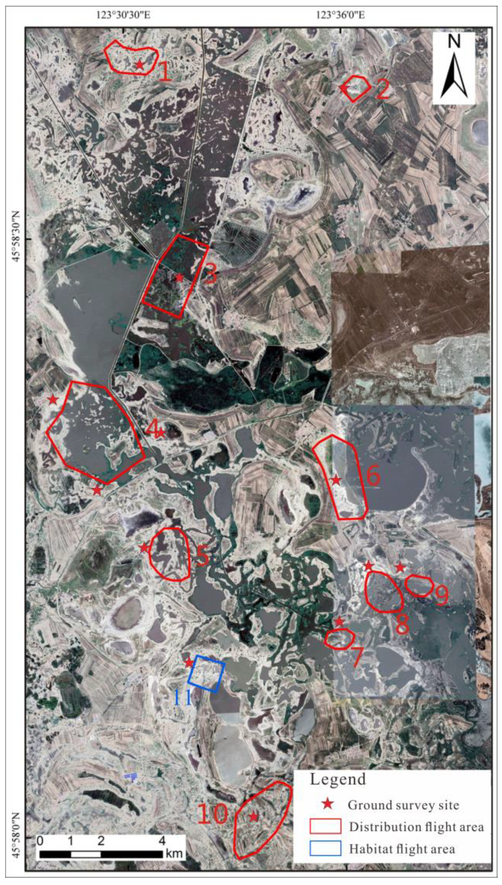
2.3.2. Distribution Flight Method

In the daily monitoring of the Momoge Reserve staff, a very important task is to accurately identify and mark the stopover sites in the Siberian cranes’ migration, which can provide critical assessment data for the crane’s habitat restoration and protection. We completed the surveys with the reserve’s staff.
The distribution survey flights were conducted from 14 to 17 October 2018. The distribution survey model was applied to investigate the Siberian crane aggregation area and areas where the cranes were suspected to be present. A total of 10 areas were investigated, and 318 photos were taken.
To quickly conduct the survey and interfere with the waterfowl as little as possible, the following steps were followed to obtain data. First, we ascended the drone to 150 m from the take-off point, set the flight parameters, allowed the lens to parallel the flight direction, and set the angle to face down 30–45°. Second, the drone flew freely with a U-shaped trajectory from the take-off point, searching for the crane until it found the suspected target and then hovered. Third, the UAV descended to a height of 100 m, quickly approached the suspected target, and descended further to judge whether the target was a Siberian crane, staying above the minimum height of 50 m. During the flight, we observed the waterfowl’s reaction at all times and adjusted the flight altitude to avoid interference. Finally, all the photos stored in the memory card were brought back indoors for processing. All flights were carried out under dry conditions. Species identification of the Siberian crane during the flight was made by the Momoge Reserve staff.
A ground survey was conducted at the same time of the day as the UAV aerial survey, where an observer located and counted the Siberian cranes using a monocular telescope.

2.4. Data Processing
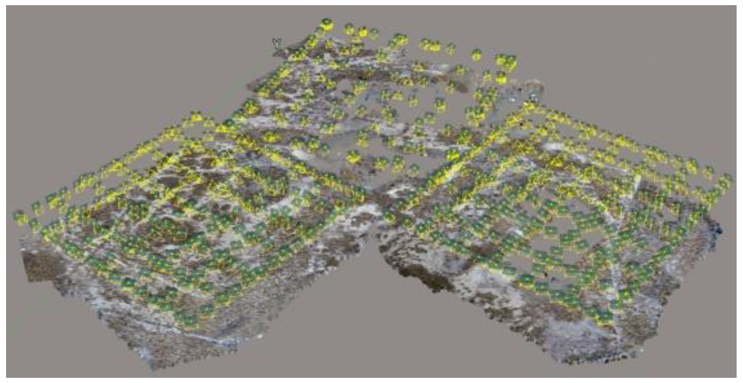
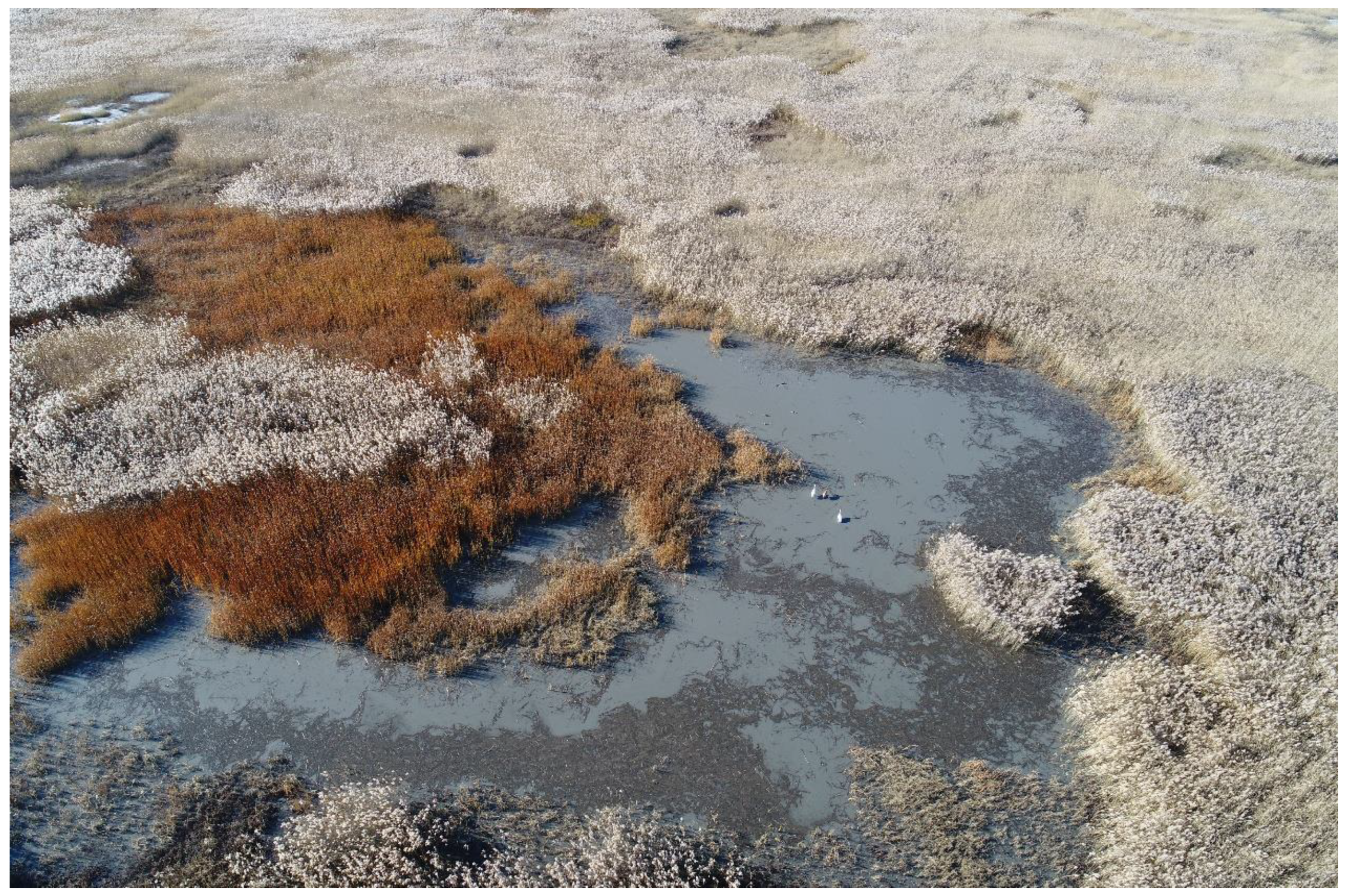
2.4.1. Habitat Map

To count the number of individuals and locate the Siberian crane aggregation area in detail, the Bentley Acute3D ContextCapture Center software was used to produce a digital orthophoto map (DOM) and to generate a 3D mesh model of the microhabitat area from the obtained RGB images. A total of 509 photos were mosaicked into a DOM map and 3D mesh model by aligning the photos, building a dense point cloud, building texture, and building the DOM and orthomosaic in the Bentley Acute3D ContextCapture Center software. This exported visual format was used to mark and locate the individual Siberian cranes in ArcMap 10.3 by artificial direct counting.

2.4.2. UAV Photographic Characteristics

Because of the distance and obstacles, there are usually barriers between the observed individuals and the investigators, preventing the investigators from identifying the types and numbers of the occluded individuals. By taking photos of the Siberian cranes, we were able to build a Siberian crane feature library based on the images from the UAV (Figure 3). The situations arising from occlusion could be effectively avoided by studying and judging the population of Siberian cranes by means of artificial visual interpretation.
In addition, by extracting the geographic coordinate information from the photographs, the number of individuals, the accurate geographical location coordinates, and the habitat types at the occurrence points could be obtained, which provided accurate basic data for further analysis such as the species distribution model.

3. Results

Our study showed that the numbers and spatial distribution of the Siberian cranes could be well mapped by UAVs, and that the adult and the young could be distinguished in the UAV images. This was possible using the details in the UAV ultra-high-resolution image and the characteristics of the Siberian crane. We could not only accurately identify and locate the individual cranes in the image but also identify the age degree, and these results were replicated in repeated checks.

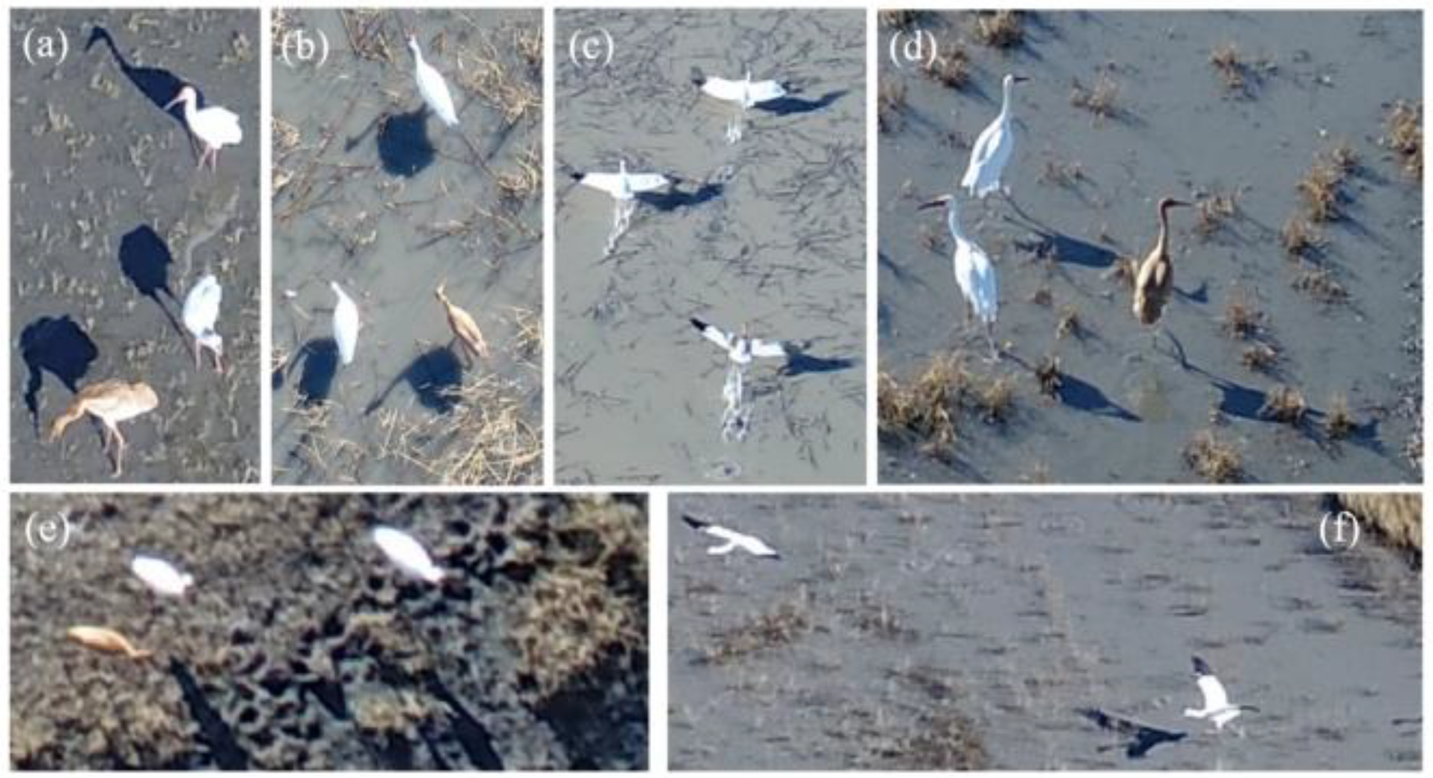
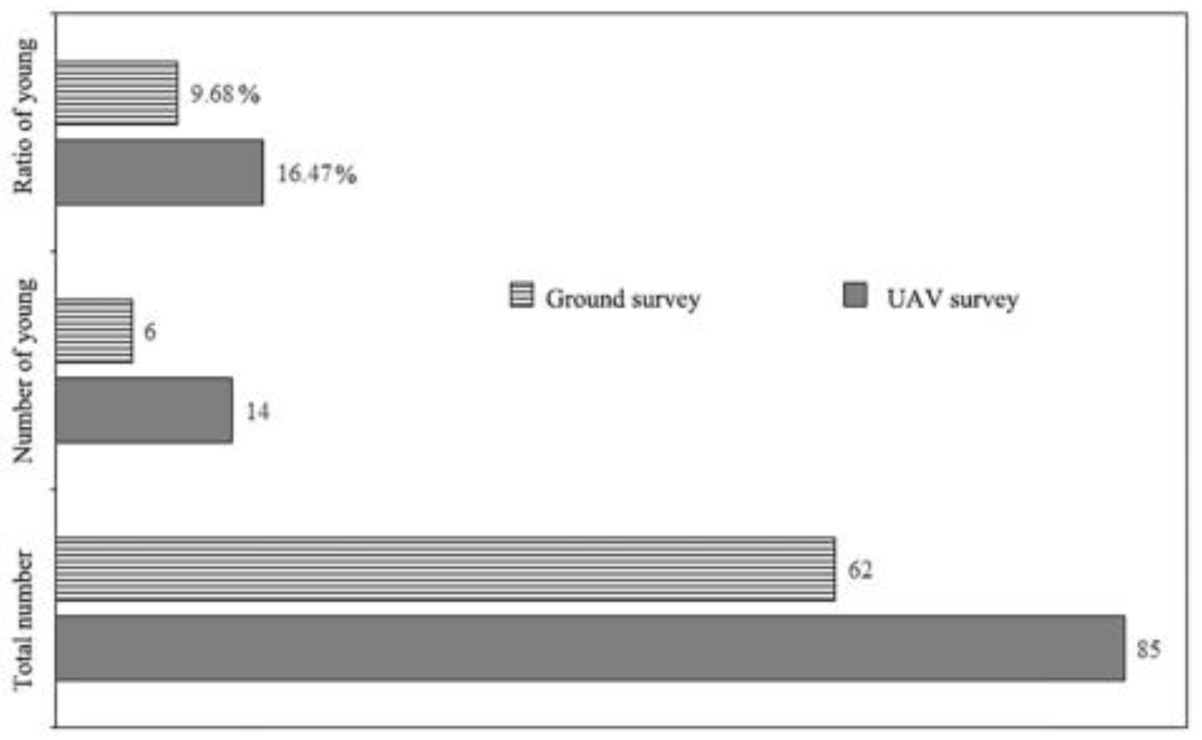
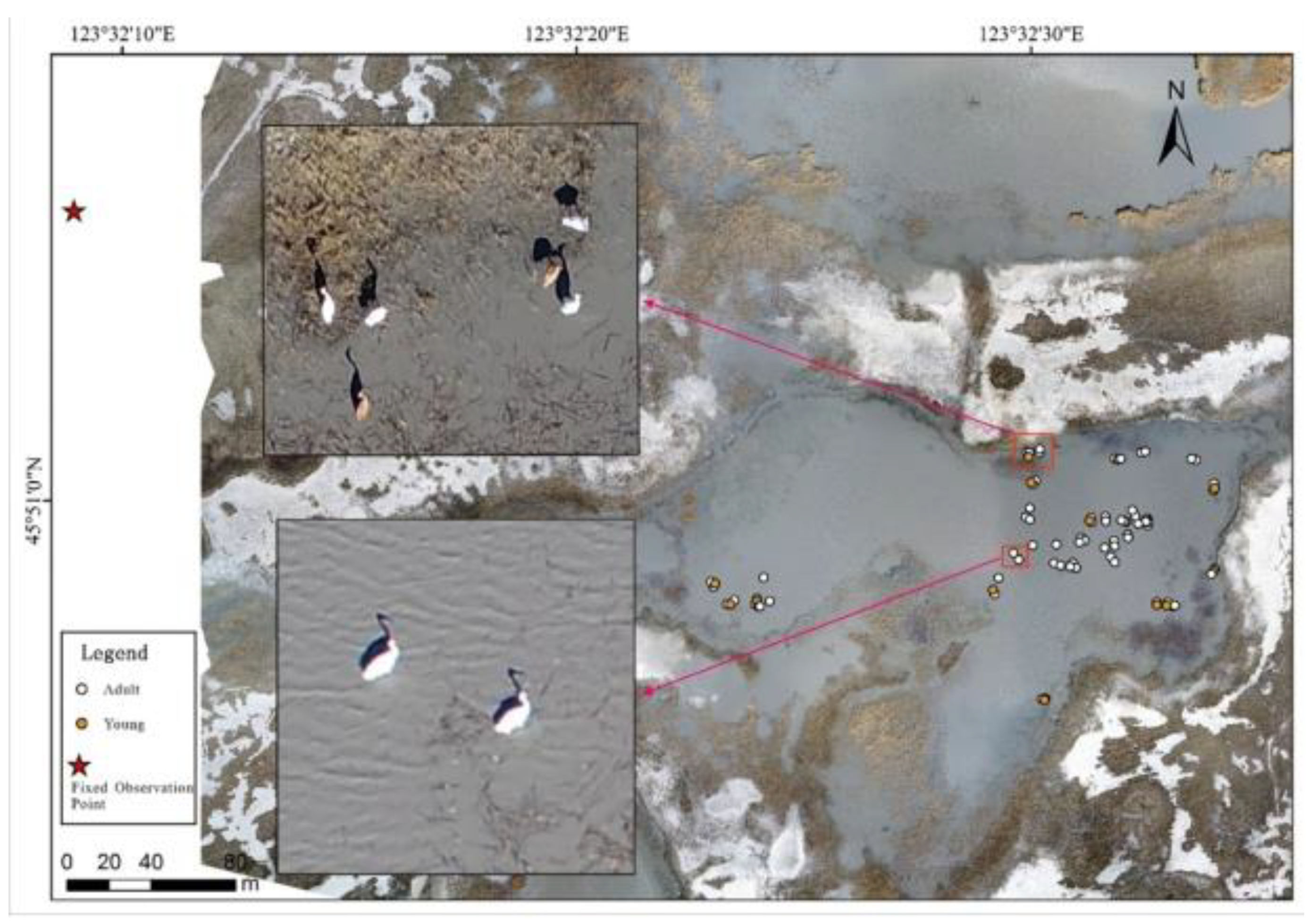
3.1. UAV Habitat Method Survey Results

In the image mosaic, there may be errors in the number of birds because of the high image overlap. Once we found suspicious phenomena, such as waterfowl flying, we would check the original image and count again. Compared with the ground survey, the UAV survey alleviated the observer’s bias. In the habitat DOM, 85 cranes were successfully identified, and 71 adults and 14 young could be distinguished (Figure 4). Based on the ground survey, 62 cranes were counted, and six young were estimated. The results of the two survey methods are shown in Figure 5.
Comparing the two survey methods, the results of the UAV survey were higher than those of the ground survey in terms of the total number of individuals and the number of young. The UAV survey recorded 37% more cranes. In addition, the proportion of young cranes reached 16.47% of the population using the UAV survey method, which was much higher than that found in the ground survey (9.68%). The ground survey not only underestimated the population size but also underestimated the number of young cranes. These results will affect the researchers’ judgments of the recovery and stability of the Siberian crane population. Therefore, using a UAV survey can provide more accurate information on the Siberian crane population relative to that gathered by the ground survey.

3.2. UAV Distribution Method Results

Compared with the ground surveys, the UAV survey improved the accuracy and probability of target discovery. In the distribution method, we surveyed ten regions and compared them with the field survey results. The results showed that the cranes could be found in five areas using the UAV, while only two sites were found by the ground surveys. The UAV survey was more effective than the ground survey in the discovery of not only areas but also numbers of individuals. The results are shown in Table 1.
In addition, we obtained photos of Siberian cranes standing in the water from the UAV overlook photography. According to the length of an adult crane leg, we could estimate the water depth in the area where the crane was located (as shown in Figure 3a,d), which cannot be obtained by the traditional ground survey method.

4. Discussion

Our research showed that the use of small, low-cost UAVs to conduct daily surveys of large waterfowl is a powerful complement to the daily monitoring of the reserve, and that it can enhance the scientific popularization and monitoring ability of the reserve and improve the scientific and technological levels of the reserve management departments. However, the impact of the UAVs’ noise and flight altitude on waterfowl should be considered in the survey. In this study, only the Siberian crane was surveyed and analyzed. When applied to other waterfowl, the UAV interference impact needs to be tested in detail beforehand, and the flight parameters and software settings must be modified.
There is an increasing amount of mission planning software that can execute automated flight, but precise flight planning must be developed in advance around the habits of the surveyed species to achieve good results. This survey selected a pertinent area and formulated its methods based on the living habits of Siberian cranes. It performed significantly better than manual surveys in terms of both the accuracy of the numbers and the discovery of cranes. Because of the possible overlaps and disturbances from unmanned aerial vehicles, the final photos could display duplicate or triplicate birds during mosaic processing. Thus, it was necessary to delete some fractions artificially to maintain the accuracy of data sets.
Automatic image analysis software has been used more frequently in UAV animal surveys, but in this survey we did not use the automatic identification function to count the cranes. To carry out waterfowl species identification using image automatic recognition technology, it is necessary to gradually establish image information databases of different species from different perspectives, combined with UAV monitoring, so as to automatically identify species and quantify species effectively [23]. Based on historical aerial surveys of waterfowl, counting errors have proved to be a serious problem [28]. Therefore, the combination of manual and automatic species identification routines for counting and the development of automatic tools to detect birds automatically have become necessary research topics [29,30,31].
Wetlands are the main habitat for waterfowl, and their terrain is generally flat. Because of the limitation of the telescope’s view, when investigators use telescopes to observe objects on the water’s surface, some phenomena such as overlapping objects and incorrect location information can result. The information directly obtained by traditional ground survey methods is usually one-dimensional; that is, from the image point of view, the distribution of all birds on the water surface is visually perceived to be linear [23]. Such factors often lead to large errors in the results. Our results showed that the UAV survey recorded 27% more cranes than were recorded by the ground method. Therefore, UAV surveys are an improvement over the traditional visual perception methods [32] and can improve the accuracy of the survey.
Owing to the living habits of Siberian cranes, their habitats are often difficult to access. Traditional ground survey methods are often limited by cover and distance. These methods may not be able to record accurate locations for targets or find them effectively. For example, in nine survey areas, owing to the influence of cover such as high reeds (like Figure 6), water, and other factors, no cranes were found by the reserve staff in the daily monitoring project. However, when using the UAV distribution mode survey, we were able to obtain side-facing photos of cranes and find the cranes quickly (Figure 6). Combined with the UAV-based Siberian crane feature library, we accurately and quickly obtained information about the numbers of cranes. Finally, we found a population of 276 cranes, and then we informed the reserve staff in a timely manner. Our research showed that a UAV survey can more quickly provide statistical data with higher accuracy for the protection of Siberian crane populations than traditional methods.
Previous studies have shown that the Siberian crane is very loyal to the stopover sites on migration routes, so the key to protecting Siberian crane populations is to protect these habitats [33,34]. To manage important habitats effectively, it is particularly important to understand the temporal and spatial selection and utilization of different habitats by the Siberian cranes. Long-term monitoring is essential for the implementation of management actions to protect the Siberian crane populations. Using UAVs to monitor Siberian crane populations and their habitats at important stopover sites during the migration season can help management departments to make more informed decisions based on accurate data, rather than relying only on the experience of observers. Through the extraction and analysis of aerial images, data information such as habitat type and area can be obtained for assessing the waterfowl’s habitat restoration and protection and for monitoring the population of endangered waterfowl such as Siberian cranes.
Because of the size and load constraints of low-cost UAVs, it is impossible to conduct long-term and large-scale surveys of waterfowl with this technology. In addition, the method is limited by the resolution of the camera; it can only distinguish large waterfowl or characteristic species without disturbing their habitats, which limits the applicability of the UAV survey method. Therefore, longer duration batteries and higher resolution cameras will be the bases for long-term and large-scale waterfowl surveys. In the future, waterfowl surveys could also be implemented by combining visible, multi-spectral, and thermal infrared cameras.

5. Conclusions

Based on the research in this paper, a low-cost UAV-based survey will almost certainly be better than or at least complement alternative methods for large waterfowl surveys. For these wetland species, the use of a UAV provides a tremendous opportunity to greatly improve the surveying of wetland waterfowl, and we anticipate that the use of UAVs to survey waterfowl will soon become a standard practice.

Author Contributions

Conceptualization, D.W., L.S. and Y.H.; methodology, D.W. and Z.X.; software, D.W. and M.L.; formal analysis, L.S. and Y.L.; investigation, D.W., Z.X. and Y.L.; resources, Y.H. and M.L.; writing—original draft preparation, D.W. and L.S.; writing—review and editing, Y.H., Z.X. and M.L.; funding acquisition, D.W. and Y.H. All authors have read and agreed to the published version of the manuscript.

Funding

The study was supported by the Basal Specific Research of the Central Public-Interest Scientific Institute (No. PM-zx703-202104-063) and the National Key Research and Development Program of China (No. 2016YFC0500401).

Data Availability Statement

The data presented in this study are available on request from the corresponding author.

Acknowledgments

We thank Yong Wang, Changlin Zou, and Baocai Xu from the Momoge National Nature Reserve for their help with fieldwork.

Conflicts of Interest

The authors declare no conflict of interest.

References

  1. MacPherson, M.P.; Webb, E.B.; Raedeke, A.; Mengel, D.; Nelson, F. A review of Bayesian belief network models as decision-support tools for wetland conservation: Are water birds potential umbrella taxa? Biol. Conserv. 2018, 226, 215–223. [Google Scholar] [CrossRef] [Green Version]
  2. Steele, B.B.; Bayn, R.L.; Grant, J.C.V. Environmental monitoring using populations of birds and small mammals: Analyses of sampling effort. Biol. Conserv. 1984, 30, 157–172. [Google Scholar] [CrossRef]
  3. Dulava, S.; Bean, W.T.; Richmond, O.M.W. Environmental Reviews and Case Studies: Applications of Unmanned Aircraft Systems (UAS) for Waterbird Surveys. Environ. Pract. 2015, 17, 201–210. [Google Scholar] [CrossRef]
  4. Jiang, H.B.; He, C.G.; Sheng, L.X.; Tang, Z.H.; Wen, Y.; Yan, T.T.; Zou, C. Hydrological Modelling for Siberian Crane Grus leucogeranus Stopover Sites in Northeast China. PLoS ONE 2015, 10, 13. [Google Scholar] [CrossRef]
  5. Kong, W.Y.; Zheng, Z.H.; Wu, J.C.; Ning, Y.; Wang, Y.; Han, X.D. Foraging habitat selection of Siberian Crane (Grus leucogeranus) during autumn migration period in the Momoge Nature Reserve. Zool. Res. 2013, 34, 166–173. [Google Scholar] [CrossRef]
  6. Li, X.M.; Cheng, R.M.; Xiao, W.F.; Pan, K.J.; Qian, F.W. Waterbird Monitoring: History, Status and Future Perspectives in China. Wetl. Sci. 2020, 18, 633–645. [Google Scholar] [CrossRef]
  7. Bako, G.; Tolnai, M.; Takacs, A. Introduction and Testing of a Monitoring and Colony-Mapping Method for Waterbird Populations That Uses High-Speed and Ultra-Detailed Aerial Remote Sensing. Sensors 2014, 14, 12828–12846. [Google Scholar] [CrossRef] [PubMed]
  8. Conroy, M.J.; Peterson, J.T.; Bass, O.L.; Fonnesbeck, C.J.; Howell, J.E.; Moore, C.T.; Runge, J.P. Sources of Variation in Detection of Wading Birds from Aerial Surveys in the Florida Everglades. Auk 2008, 125, 731–743. [Google Scholar] [CrossRef]
  9. Bridge, E.S.; Thorup, K.; Bowlin, M.S.; Chilson, P.B.; Diehl, R.H.; Fléron, R.W.; Hartl, P.; Kays, R.; Kelly, J.F.; Robinson, W.D.; et al. Technology on the Move: Recent and Forthcoming Innovations for Tracking Migratory Birds. Bioscience 2011, 61, 689–698. [Google Scholar] [CrossRef] [Green Version]
  10. Christie, K.S.; Gilbert, S.L.; Brown, C.L.; Hatfield, M.; Hanson, L. Unmanned aircraft systems in wildlife research: Current and future applications of a transformative technology. Front. Ecol. Environ. 2016, 14, 242–252. [Google Scholar] [CrossRef]
  11. Gonzalez, L.F.; Montes, G.A.; Puig, E.; Johnson, S.; Mengersen, K.; Gaston, K.J. Unmanned Aerial Vehicles (UAVs) and Artificial Intelligence Revolutionizing Wildlife Monitoring and Conservation. Sensors 2016, 16, 97. [Google Scholar] [CrossRef] [PubMed] [Green Version]
  12. Fortuna, J.; Ferreira, F.; Gomes, R.; Ferreira, S.; Sousa, J. Using low cost open source UAVs for marine wild life monitoring-Field Report. IFAC Proc. Vol. 2013, 46, 291–295. [Google Scholar] [CrossRef]
  13. Chabot, D.; Bird, D.M. Wildlife research and management methods in the 21st century: Where do unmanned aircraft fit in? J. Unmanned Veh. Syst. 2015, 3, 137–155. [Google Scholar] [CrossRef] [Green Version]
  14. Rey, N.; Volpi, M.; Joost, S.; Tuia, D. Detecting animals in African Savanna with UAVs and the crowds. Remote Sens. Environ. 2017, 200, 341–351. [Google Scholar] [CrossRef] [Green Version]
  15. Weissensteiner, M.H.; Poelstra, J.W.; Wolf, J.B.W. Low-budget ready-to-fly unmanned aerial vehicles: An effective tool for evaluating the nesting status of canopy-breeding bird species. J. Avian Biol. 2015, 46, 425–430. [Google Scholar] [CrossRef]
  16. Sardà-Palomera, F.; Bota, G.; Viñolo, C.; Pallarés, O.; Sazatornil, V.; Brotons, L.; Gomáriz, S.; Sardà, F. Fine-scale bird monitoring from light unmanned aircraft systems. Ibis 2012, 154, 177–183. [Google Scholar] [CrossRef]
  17. Scholten, C.N.; Kamphuis, A.J.; Vredevoogd, K.J.; Lee-Strydhorst, K.G.; Atma, J.L.; Shea, C.B.; Lamberg, O.N.; Proppe, D.S. Real-time thermal imagery from an unmanned aerial vehicle can locate ground nests of a grassland songbird at rates similar to traditional methods. Biol. Conserv. 2019, 233, 241–246. [Google Scholar] [CrossRef]
  18. Drever, M.C.; Chabot, D.; O’Hara, P.D.; Thomas, J.D.; Breault, A.; Millikin, R.L. Evaluation of an unmanned rotorcraft to monitor wintering waterbirds and coastal habitats in British Columbia, Canada. J. Unmanned Veh. Syst. 2015, 3, 256–267. [Google Scholar] [CrossRef]
  19. Chabot, D.; Craik, S.R.; Bird, D.M. Population census of a large common tern colony with a small unmanned aircraft. PLoS ONE 2015, 10, e0122588. [Google Scholar] [CrossRef] [Green Version]
  20. Jiang, H.; Wen, Y.; Zou, L.; Wang, Z.; He, C.; Zou, C. The effects of a wetland restoration project on the Siberian crane (Grus leucogeranus) population and stopover habitat in Momoge National Nature Reserve, China. Ecol. Eng. 2016, 96, 170–177. [Google Scholar] [CrossRef]
  21. Kanai, Y.; Ueta, M.; Germogenov, N.; Nagendran, M.; Mita, N.; Higuchi, H. Migration routes and important resting areas of Siberian cranes (Grus leucogeranus) between northeastern Siberia and China as revealed by satellite tracking. Biol. Conserv. 2002, 106, 339–346. [Google Scholar] [CrossRef]
  22. Qi, Z.; Yang, N.; Mei, J.W.; Hua, L.G. Current Status and Conservation of The Siberian Crane. Wetl. Sci. Manag. 2019, 15, 43–45. [Google Scholar] [CrossRef]
  23. Li, J.; Liu, Q. Prerequisites of Waterfowl Monitoring Using Unmanned Aerial Vehicle. Trop. Geogr. 2019, 39, 546–552. [Google Scholar] [CrossRef]
  24. Dundas, S.J.; Vardanega, M.; O’Brien, P.; McLeod, S.R. Quantifying Waterfowl Numbers: Comparison of Drone and Ground-Based Survey Methods for Surveying Waterfowl on Artificial Waterbodies. Drones 2021, 5, 5. [Google Scholar] [CrossRef]
  25. McEvoy, J.F.; Hall, G.P.; McDonald, P.G. Evaluation of unmanned aerial vehicle shape, flight path and camera type for waterfowl surveys: Disturbance effects and species recognition. PeerJ 2016, 4, e1831. [Google Scholar] [CrossRef] [PubMed] [Green Version]
  26. Wang, Y.J.; Fang, W.W.; Li, X.M. Behavior of Siberian Crane During Spring in Momoge Nature Reserve, Jilin Province, China. Chin. J. Wildl. 2012, 33, 67–70. [Google Scholar] [CrossRef]
  27. Cui, M.H.; Zheng, L.Q. Observation of Behavior of Grus leucogeranus’ Migration in Fall. For. Inventory Plan. 2006, 4, 94–97. [Google Scholar] [CrossRef]
  28. Kingsford, R.T.; Porter, J.L. Monitoring waterbird populations with aerial surveys what have we learnt? Wildl. Res. 2009, 36, 29–40. [Google Scholar] [CrossRef]
  29. Lyons, M.; Brandis, K.; Callaghan, C.; McCann, J.; Mills, C.; Ryall, S.; Kingsford, R. Bird interactions with drones, from individuals to large colonies. Aust. Field Ornithol. 2018, 35, 51–56. [Google Scholar] [CrossRef] [Green Version]
  30. Descamps, S.; Béchet, A.; Descombes, X.; Arnaud, A.; Zerubia, J. An automatic counter for aerial images of aggregations of large birds. Bird Study 2011, 58, 302–308. [Google Scholar] [CrossRef]
  31. Grenzdörffer, G.J. UAS-based automatic bird count of a common gull colony. Int. Arch. Photogramm. Remote Sens. Spat. Inf. Sci. 2013, 1, 169–174. [Google Scholar] [CrossRef] [Green Version]
  32. Anderson, K.; Gaston, K.J. Lightweight unmanned aerial vehicles will revolutionize spatial ecology. Front. Ecol. Environ. 2013, 11, 138–146. [Google Scholar] [CrossRef] [Green Version]
  33. Li, X.; Xu, J.; Qian, F. Migration Routes of Siberian Crane (Grus leucogeranus) in Spring and Autumn by Satellite Tracking. Wetl. Sci. 2016, 14, 347–353. [Google Scholar]
  34. Wen, D.; Hu, Y.; Xiong, Z.; Chang, Y.; Li, Y.; Wang, Y.; Liu, M.; Zhu, J. Potential Suitable Habitat Distribution and Conservation Strategy for the Siberian Crane (Grus leucogeranus) at Spring Stopover Sites in Northeasternern China. Pol. J. Environ. Stud. 2020, 29. [Google Scholar] [CrossRef]
Figure 1. The study area.
Drones 05 00102 g001
Figure 2. Map showing the locations of the 509 UAV multi-view stereo images.
Drones 05 00102 g002
Figure 3. Imagery of the Siberian cranes from the UAV. The cranes were resting or foraging (a,b,d,e), the cranes were flying (c,f).
Drones 05 00102 g003
Figure 4. The age degree and distribution of the Siberian crane map created from the UAV habitat method.
Drones 05 00102 g004
Figure 5. Contrast map of UAV survey and ground survey results.
Drones 05 00102 g005
Figure 6. A UAV-based RGB image used to identify the waterfowl species and habitat.
Drones 05 00102 g006
Table 1. Comparative table of UAV and field survey results.
Area NumberUAV SurveyGround Survey
Crane DetectionNumberCrane DetectionNumber
1Yes3Yes2
2Yes3Yes1
3No No
4No No
5Yes3No
6No No
7No No
8Yes9No
9Yes276No
10No No
Publisher’s Note: MDPI stays neutral with regard to jurisdictional claims in published maps and institutional affiliations.

