Article

A Method for Selecting Strategic Deployment Opportunities for Unmanned Aircraft Systems (UAS) for Transportation Agencies

1
Purdue University School of Aviation and Transportation Technology, Purdue University Polytechnic Institute, West Lafayette, IN 47907, USA
2
Purdue University School of Construction Management Technology, Purdue University Polytechnic Institute, West Lafayette, IN 47907, USA
*
Author to whom correspondence should be addressed.
Drones 2020, 4(3), 29; https://doi.org/10.3390/drones4030029
Submission received: 16 June 2020 / Revised: 26 June 2020 / Accepted: 30 June 2020 / Published: 2 July 2020

Abstract

:
Unmanned aircraft systems (UAS) are increasingly used for a variety of applications by state Departments of Transportation (DOT) and local transportation agencies due to technology advancements, lower costs, and regulatory changes that have simplified operations. There are numerous applications (e.g., bridge inspection, traffic management, incident response, construction and roadway mapping) and agencies find it challenging to prioritize which applications are most appropriate. Important factors to consider when prioritizing UAS applications include: (1) benefits, (2) ease of adoption, (3) stakeholder acceptance, and (4) technical feasibility. These factors can be evaluated utilizing various techniques such as the technology acceptance model, benefit analysis, and technology readiness level (TRL). This paper presents the methodology and results for the prioritization of UAS applications’ quality function deployment (QFD), which reflects both qualitative and quantitative components. The proposed framework can be used in the future as technologies mature, and the prioritization can be revised on a regular basis to identify future strategic implementation opportunities. Numerous transportation agencies have begun to use UAS, some have developed UAS operating policies and manuals, but there has been no documentation to support identification of the UAS applications that are most appropriate for deployment. This paper fills that gap and documents a method for identification of UAS applications for strategic deployment and illustrates the method with a case study.

Graphical Abstract

1. Introduction

The objective of this paper is to present a process for state Departments of Transportation (DOTs) and local transportation agencies to prioritize applications for the strategic deployment of unmanned aerial systems (UAS). Key tasks in this process include documentation of candidate UAS deployments by transportation agencies, development of a framework for prioritizing UAS applications for an agency, and presentation of a case study to provide an example of the prioritization process for a transportation agency, in this case a DOT.
The prioritization of candidate UAS applications reflects a number of factors including stakeholder willingness to accept the new technology for the application, how easily the technology can be adopted for the application, the benefits associated with the deployment, and if the UAS technology can reliably support the proposed application.
Stakeholder willingness to accept UAS can vary significantly, depending on the application and stakeholders. Stakeholder acceptance reflects both the organizational acceptance (e.g., culture, management objectives, organizational structure and policies), and the individual acceptance. Stakeholder acceptance of technology and ease of adoption reflect how user-friendly the technology is for individual workers, as well as financial and regulatory considerations that may make adoption more challenging.
The benefits of UAS vary depending on the application, and may include safety for transportation workers, safety for the traveling public, costs savings for the transportation agency and the traveling public, and increased capabilities for the transportation agency. Cost savings may include the value of time for the traveling public, the value of time and equipment for the transportation agency, and the value of increased safety in terms of accidents and injuries avoided.
Technical feasibility reflects the maturity of the technology for the proposed application. This may encompass factors such as control and sensor capabilities, as well as battery life, and operation in the actual environment. The technology also needs to be proven technically feasible for the proposed deployment in the actual environment, which may include wind, rain, and other harsh and sometimes unpredictable environmental challenges.
Based on the stakeholder acceptance, ease of adoption, benefits, and technical feasibility, prioritization of potential applications can be accomplished utilizing both quantitative and qualitative techniques. The consolidation of these prioritizations results in an identification of strategic opportunities for DOTs.

Overview of UAS Applications for DOTs

Simplified UAS operations under Part 107, in combination with advancements in UAS technology and the resulting lower prices, have resulted in a dramatic increase in the prevalence of UAS. The growth in UAS has facilitated an increasing number of potential UAS applications. Many government agencies have recognized the benefits and potential benefits of UAS, and UAS have been deployed at both the state and local level to support a wide range of agency activities. UAS have been implemented as standard practice for some applications, and as demonstrations and investigations for other applications. The potential for UAS to provide a valuable tool has been reflected by investigations, demonstrations, and even deployment as standard practices at DOTs and transportation agencies.
There are a number of UAS applications that have been documented in the scholarly literature, the media, and in UAS consultant reports and websites. Public agencies have incorporated UAS for a wide variety of applications, from emergency response and disaster management to vegetation management (e.g., to assess invasive species and to identify illegally grown marijuana), and construction and infrastructure management (e.g., bridge inspections and construction inspections).
For over a decade, UAS have been proposed as a means to provide rapid and accurate information to first responders, and as a tool to provide real-time visual confirmation to the wide variety of stakeholders who participate in emergency response activities [1]. Although regulation historically limited the utilization of UAS in emergencies [2], the promulgation of Part 107 in 2016 significantly reduced regulatory constraints, and simplified the process for legal operation. Used properly, UAS are a valuable tool that may provide excellent documentation of conditions, enhance situational awareness, allow distant experts to provide technical assistance in real-time, facilitate communications and the data collection, and reduce injuries and increase safety for both day-to-day operations and during emergencies.
UAS are used for a variety of tasks to support construction and infrastructure management, including surveying and pre-construction activities (e.g., lidar, 2D and 3D mapping and imaging), documentation of earthwork quantities, documentation of construction progress and activities, inspections, and aerial photographs and video for communication and project documentation [3,4]. UAS may also be a useful tool to support quality control and worker safety [5]. High-resolution photographs and advanced image processing are facilitated by UAS data collection and are useful in pavement infrastructure monitoring [6,7]. A number of methods have been developed to provide image processing for a condition assessment based on high-resolution photos. A condition assessment can also be enhanced by the use of other UAS remote sensing technologies such as laser scanners (including lidar), ground penetrating radar (GPR), thermal imaging, and acoustics [7].
In addition to DOTs and local transportation agencies, other state and local agencies are using UAS to increase their capabilities and, in some cases, lower their costs. Example agencies that use UAS include State Police and local law enforcement, fire fighters and emergency responders, Departments of Natural Resources, Departments of Environmental Management, Departments of Fish and Wildlife, local drainage boards, local surveyors, and Departments of Ecology. Universities are often collaborative partners in the exploration and development of new UAS applications.
There have been a number of surveys of state DOTs in recent years to identify agencies that are actively using UAS, both for research and in standard practice for regular activities. These surveys generally indicate increasing interest. In March 2016, the American Association of State Highway and Transportation Officials (AASHTO) conducted a survey that found that 17 state DOTs had studied or used UAS, and another 16 state DOTs were exploring applications, assisting in policy development, or supporting UAS research [8]. In August 2016, a survey of DOTs by Kansas DOT indicated that seven had submitted requests for a Certificate of Authorization (COA) exemption and seven were considering purchasing a UAS once regulations allowed for commercial use when Part 107 became effective on August 29, 2016 [9]. By March 2018, AASHTO reported the results of another survey, which indicated that 20 state DOTs were using UAS for daily operations, and 15 more DOTs were researching how UAS could best be deployed [10].
There are a very wide range of UAS applications that have been implemented, investigated, and explored. Table 1 provides a partial list of UAS applications. Some applications, such as bridge inspections, have been studied by numerous agencies. For example, Michigan DOT has worked with Michigan Tech for more than four years, and has found UAS to be a safe, reliable, and cost-effective tool [10]. Minnesota DOT has also worked with UAS for bridge inspections for a number of years, partnering with Collins Engineering [11]. Other DOTs have also utilized UAS for bridge inspections as an agency activity, but have done so without documentation in scholarly research reports.
North Carolina DOT has worked with the State Highway Patrol to deploy UAS for incident management, and has found that crash reconstruction times using UAS can potentially be reduced to less than one fourth of the time required using traditional reconstruction methods (25 min with a UAS vs. 111 min with traditional methods). This reduction in time translates to the road opening sooner, which can save USD 5000 per interstate crash, considering only user delay and the associated lost productivity [10]. DOTs that use UAS for regular activities report the following top five missions [12]:
  • Photo/video;
  • Surveying;
  • Infrastructure inspections;
  • Emergency response/natural disasters;
  • Public education and outreach.
These missions can be used for a variety of applications that support DOT responsibilities, as listed in Table 1. UAS for environmental compliance includes not only wetlands monitoring, but also roadside air quality monitoring [13]. Roadway and bridge applications include pavement and bridge inspections, as well as traffic monitoring. UAS for pavement inspections may include crack detection and mapping, as well as monitoring pavements on expansive soils [14]. UAS for traffic monitoring may include detection of recurrent or non-recurrent congestion [15] as well as wrong-way entries onto the interstate [16]. Some agencies have responsibilities for airports, in which case, UAS can be used for daily activities such as security (e.g., perimeter control) as well as periodic inspections such as obstruction monitoring, which ensures aircrafts have a safe path for approach and departure that is free from encroaching vegetation and manmade obstacles such as buildings and cranes. UAS have also proven useful for a variety of emergency response activities, including crash investigations, which may encompass remote inspection of the accident scene to protect personnel, and documentation of the accident scene. There are numerous other applications, ranging from use of video and images as a communication tool with the public and decision-makers, to studies for pedestrians and bikes. Pedestrian and bike studies include UAS for pedestrian observation [17]. UAS have also been used as part of a crash warning system for the bike lane at intersections with connected vehicle technology [18].
The applications presented in Table 1 are generally consistent with previous research that suggests the applications of greatest interest to transportation agencies may support the following activities [19]:
  • Asset management including infrastructure inspection (significant overlap with roadway and bridge applications in Table 1);
  • Construction;
  • Disaster management (encompasses emergency response in Table 1);
  • Environmental monitoring;
  • Safety;
  • Surveillance;
  • Traffic operations.
The agency structure for UAS deployment (e.g., whether UAS are owned and deployed at the district level or from the central office), may have a significant impact on how quickly deployment occurs and how widely UAS are implemented.

2. Method

There are over forty UAS applications (as illustrated by Table 1) and UAS can be used in different ways to support many of these applications. Given the broad possibilities for UAS, it is valuable for an agency to identify the best opportunities for early success and strategically implement UAS as a tool for these applications. This will give the agency an opportunity to learn from UAS in a strategic way and limit risk while still advancing organizational innovation. In order to prioritize the strategic opportunities, a methodology was developed that reflected assessment for the following areas:
  • Stakeholder acceptance and ease of adoption;
  • Benefits;
  • Technical feasibility.
Assessment may include both qualitative and quantitative components. Results from assessment areas are then combined for evaluation using the (TQM) quality function deployment (QFD) method, a method widely used in other sectors, including total quality management (TQM). Additional information about the assessment areas and QFD are provided below, with the prioritization methodology illustrated using a case study for a DOT.

2.1. Assessment Areas

The three assessment areas used for this prioritization include stakeholder acceptance and ease of adoption, benefits, and technical feasibility. For some agencies, it may be appropriate to have more assessment areas or otherwise tailor the assessment areas to meet agency needs. For example, it would be reasonable to separate stakeholder acceptance and ease of adoption into separate assessment areas, and/or separate benefits into agency benefits and public benefits. Separating out the assessment areas would allow them to be clearly communicated and weighted separately, according to agency goals. Weightings can be determined by a survey of stakeholders, or through processes such as the Delphi method, which is based on iterations by knowledgeable experts. In this case study, all three assessment areas are equally weighted.

2.1.1. Stakeholder Acceptance and Ease of Use

Stakeholder acceptance reflects the organizational and individual support or concerns with the proposed deployment. Stakeholders potentially include all organizations and individuals who would be affected by the proposed technology deployment, including people and organizations that use the technology (e.g., district personnel), interface with the technology, pay for the technology (e.g., taxpayers), or are affected by its deployment in any other way. Stakeholder acceptance would include both labor and management perspectives, as well as public perception.
One of the most broadly used frameworks for stakeholder acceptance is the technology acceptance model (TAM) which states that perceived usefulness and perceived ease of use are the main determinants for an individual’s use of a technology [20]. Perceived usefulness reflects whether workers believe the technology will help carry out a task. Perceived ease of use is how much effort is needed to properly use the technology. The unified theory of acceptance and use of technology [21] provides additional context for technology and recognizes social influence and organizational factors such as facilitating conditions and whether use is voluntary.
Ease of adoption refers to how easily the technology can be deployed, considering physical and financial requirements of the proposed deployment, as well as regulatory, institutional, and political considerations.
Stakeholder acceptance and ease of adoption are closely related and together they reflect the potential challenges or support in adopting UAS for a given application, and in this case are called stakeholder input. In addition to reflecting individual characteristics, such as whether DOT workers would use the technology if it were available, and institutional characteristics, such as management support, stakeholder input would reflect support and constraints due to external organizations that provide regulation and oversight. This would include the Federal Highway Administration (FHWA) for bridge inspection requirements and the Federal Aviation Administration (FAA) for requirements related to use of UAS (e.g., under Part 107). Stakeholder input would also reflect any partner organizations that may be affected (e.g., emergency responders in the case of a roadway crash, or external partners such as construction contractors). As the assessment becomes more robust, future assessment may reflect more detailed analysis (e.g., attitude of individual users, compatibility of the proposed technology with task, etc.).

2.1.2. Benefits

Benefits include the benefits and costs associated with the proposed technology application. Benefits may be assessed using quantitative data, when available, or may be assessed qualitatively. Benefits may include improved operations, improved efficiency, increased safety, and reduced costs. Benefits may also be assessed based on whether the UAS deployment supports the agency’s mission and goals. Examples may include improved operations during regular conditions, improved operations during emergencies, increased safety for the traveling public and workers, increased mobility, increased efficiency, and reduced costs, and applications that provide communication (with the public and within the agency) and support education (including public education) and workforce training.

2.1.3. Technical Feasibility

Technical feasibility refers to the practicality and maturity of the proposed technology deployment, including the equipment, machinery, computers, or automation in the context of the environment in which it will operate. The technical feasibility of a candidate application reflects the maturity of the proposed technology for a specific application as demonstrated through simulations, investigations, demonstrations, or full deployment into standard practice in the actual environment. The maturity of a technology is often measured by the technology readiness level (TRL), which has been widely used in the defense industry and is determined using a technology readiness assessment (TRA). A TRA examines the following areas: (general) technology readiness, safety concerns, risk criteria, and sustainability. The resulting TRL ranges from 1 to 9 with 1 representing the lowest level of readiness and 9 representing a technology that has been successfully deployed into practice as part of standard operating procedures, as shown in Figure 1.

2.2. Combine Assessment Information into an Evaluation Score

To prioritize the potential applications, it is useful to combine the results from all assessment areas into a single score. In this case, the evaluation must combine both quantitative and qualitative assessment information. Stakeholder input is inherently qualitative. Since there are limited data regarding UAS deployments, at this point, the benefits are also qualitative. Even when benefits data are available in the future, there is typically a qualitative component to benefits assessment since some benefits are hard to quantify. It is useful to translate both of these qualitative assessments to a quantitative metric, which can be accomplished using the QFD method. As mentioned previously, QFD is a multi-attribute utility theory that has been used in TQM as well as in the auto and aerospace industries by companies such as Ford, Boeing, and McDonnel Douglass [22].
In QFD evaluation, a composite score for each candidate project is based on scores of 0, 1, 3, or 9. A score of 0 indicates that there is no difference or preference, a score of 1 indicates a marginal or weak preference, a score of 3 indicates a measurable or medium preference, and a score of 9 indicates clear superiority or a strong preference. While it is also possible to assign scores from 0 to 10 on an integer scale, it is often very challenging to assign to meaningfully differentiate between possible scores (e.g., it is hard to judge whether a qualitative assessment should be assigned a score of 6 rather than 7), however, it is easier to recognize whether there is no preference, a weak preference, a measurable preference, or a strong preference.
The use of QFD is intended to provide a means to clearly communicate qualitative (and in some cases somewhat ambiguous) information for the purposes of discussion and transparent decision-making. The evaluation is not intended to suggest that one application is inherently preferable to another, but rather to communicate the findings of preliminary interviews and the information available during this prioritization. Assignment of values can illuminate where differences of opinion may exist, and provide an opportunity for stakeholders to share their perspectives on a variety of aspects that relate to the new technology.
The prioritization of UAS applications for a DOT using the proposed methodology is illustrated using a case study below.

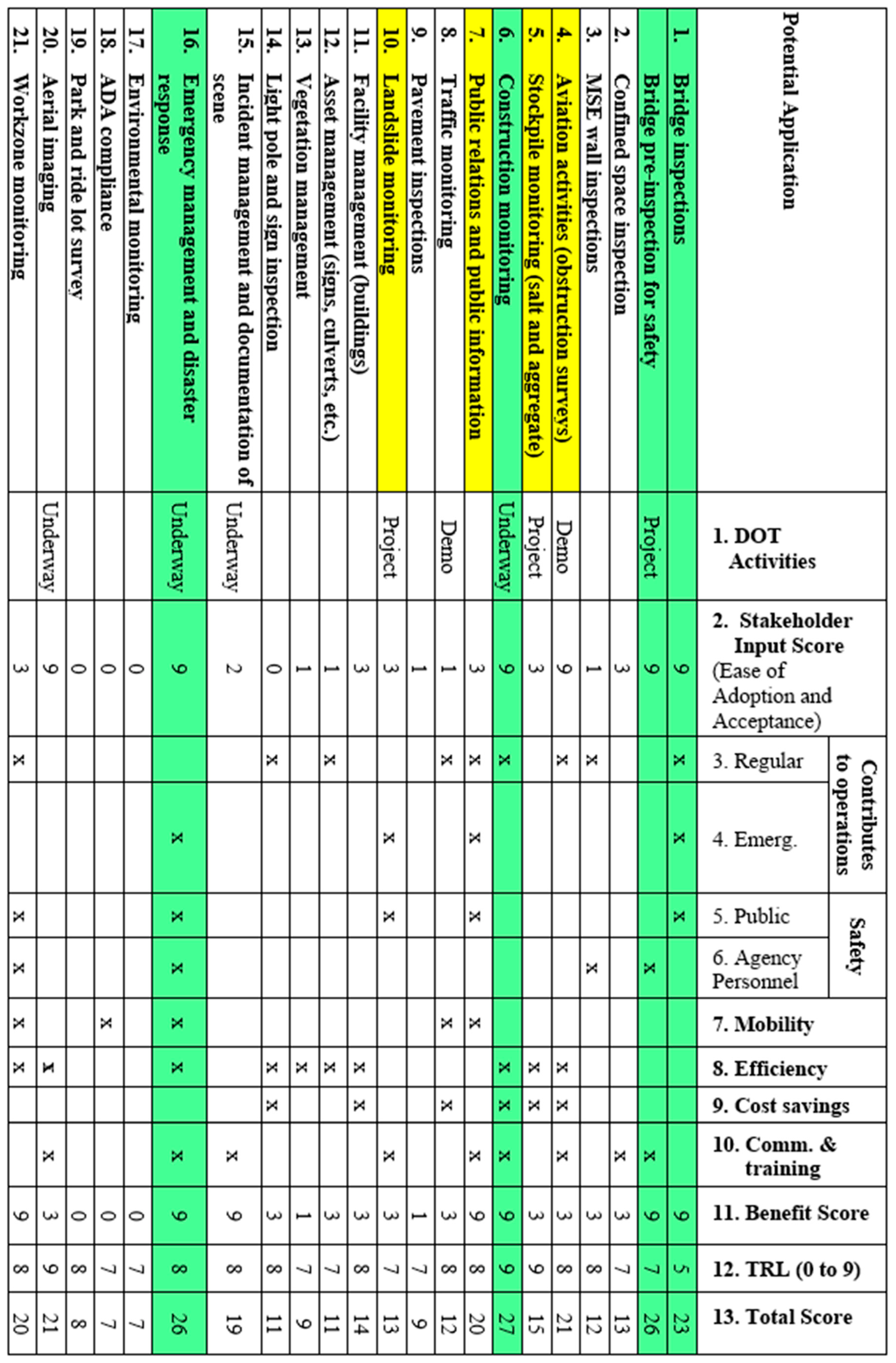
3. Results of a Case Study at a State DOT

The results of the most recent AASHTO survey indicate less than half of the DOTs have incorporated UAS into their daily activities. Identifying which applications from the long list in Table 1 are most appropriate for an agency is an important first step. In this case study, a list of 21 candidate applications for evaluation was developed based on the list of applications in Table 1, refined to reflect the priorities indicated during stakeholder interviews. The resulting list of 21 candidate applications was evaluated in greater detail. Assessment included qualitative information for stakeholder input, qualitative input for benefits, and quantitative assessment for technical feasibility. The information from these three assessment areas was integrated using QFD, as discussed in greater detail below.

3.1. Assessment Results: Stakeholder Input

Stakeholder input reflects both ease of adoption and stakeholder acceptance. Stakeholder input was obtained during a series of more than 25 interviews with DOT personnel and with contractors that work for the DOT. A list of example stakeholders that participated is shown in Table 2. Concepts shared at the interviews are shown in Table 3.
Stakeholder input is assessed based on activities that have been initiated or are planned by the DOT and partner agencies (shown in Column 1 of Figure 2) as well as the results of the interviews with DOT personnel and other stakeholders, which are considered indicative of interest in adopting UAS for the candidate applications.
DOT activities are categorized as a “Demonstration”, “Project”, or “Underway” in Column 1 of Figure 2. “Demonstration” or “Demo” reflect an agency activity that has been tried but not incorporated into practice. “Project” reflects a proposed or existing research project funded by the agency and conducted by a university partner. “Underway” reflects a practice that is underway or is being adopted by the agency.
In some cases, such as for traffic monitoring, the DOT has done a demonstration with UAS, as indicated by “Demo”, but the use of a UAS for this application is not part of regular operations or standard procedures. In other cases, the interview findings indicated that UAS are already being implemented as part of the DOT procedures, indicated as “Underway”. In the case of aerial imaging, UAS have been purchased and are a regular part of the DOT procedures. For incident management, the DOT is supporting the use of UAS by State Police and local law enforcement to facilitate the timely documentation of the accident scene and return to normal operations.
The stakeholder interviews illustrated that in a large organization such as a DOT, UAS activities may be underway, although these activities may not be widely communicated throughout the agency or undertaken as part of a larger formalized agency program.
One consultant interviewed mentioned that some DOTs are already in the UAS business even if they do not realize it, since the consultant has been using UAS for products delivered to DOTs. Similarly, interviews with DOT personnel from an agency implementing a comprehensive UAS program discovered that some district personnel were already using UAS, even though it had not been formally deployed at the agency level. This illustrates that the findings of the stakeholder interviews provided benefits in terms of coordination and communication, in addition to the value related to the prioritization of UAS applications.
The overall assessment of stakeholder input (reflecting stakeholder acceptance and ease of adoption) reflects the results of activities underway and planned (Column 1) and the results of stakeholder interviews (Column 2) of Figure 2.

3.2. Assessment: Benefits

UAS application may be easy to adopt and technically feasible, but if it does not provide adequate benefits, then there is little value in deployment. The benefits assessed in this case reflect whether the proposed UAS application would support the DOT missions, values, and goals [24] described below. UAS deployment for application supports agency missions, values, and goals:
  • Contributes to the operation of the transportation system during regular operations;
  • Contributes to the operation of the transportation system during emergency situations;
  • Increases transportation system safety for the traveling public;
  • Increases safety for the DOT workforce;
  • Increases mobility for the traveling public.
Other important benefits captured in this analysis include a qualitative assessment of the following:
  • Improves efficiency;
  • Provides cost savings;
  • Supports communications, education, and training.
Improved efficiency and cost savings and communications with the public and public education are consistent with the 2019 Agency Goals to deliver great service and improve construction and maintenance processes and business practices [24]. Supports communications within DOTs and education and training for DOT personnel are important components of the agency goal to develop an advanced workforce.

3.3. Assessment: Technical Feasibility

Technical feasibility was assessed using the TRL based on the reported experience by other agencies, consultants, and in some cases, activities within the department. A TRL of 9 reflects the most advanced technology, which would be off-the-shelf capabilities which have been proven in the environment. For many UAS applications, the technologies are still evolving and there is a degree of uncertainty associated with their operation, which increases the importance of qualitative information and assessment, which is captured in the stakeholder input and benefits assessment areas.

3.4. Evaluation: Combining Information from Assessmen Areas

Due to the qualitative nature of some components of assessment, which may reflect concepts rather than data, the proposed evaluation is a mix of quantitative and qualitative information. As mentioned previously, the QFD method reflecting a score of 0, 1, 3, or 9 reflects no difference, minor preference, measureable preference, or significant preference. The score for technical feasibility is an integer rating between 0 and 9, reflecting the technical feasibility as measured by the TRL. In this case, each of the three assessment areas was equally weighted in the final score. It would also be possible to vary the weight of each assessment area to reflect agency priorities.
For stakeholder input, Column 1 reflects current activities at the DOT and Column 2 is the overall stakeholder input QFD score based on both the stakeholder input from Table 3 and UAS current activities at the DOT in Column 1. The highest ranking opportunities in terms of ease of adoption and stakeholder acceptance tend to be applications that are already underway at the DOT which would indicate strong stakeholder support.
For the assessment of the benefits, the overall benefits score is shown in Column 11 of Figure 2, and reflects the potential benefits to the DOT and public, as shown in Columns 3 through 10. The overall benefits that are expected for an application are indicated with an “x”. In the future, it would be possible to rank or rate the magnitude of the benefits based on quantitative values such as return on investment, dollars saved, or the benefit cost ratio associated with using UAS for a given application. This kind of quantitative analysis will be more feasible in the future, as technologies mature and more information is available. Potential applications with numerous benefits were scored higher than those with few benefits based on the QFD scale.
Technical feasibility, as ranked based on the TRL, is shown in Column 12 of Figure 2. A number of factors went into this ranking, including the current DOT activities noted in Column 1, information from the literature, and input from UAS professionals that were interviewed.

3.5. Prioritization of Potential Applications

The final scoring is shown in Column 13 of Figure 2 for the 21 potential applications. The proposed method can be used to re-prioritize potential UAS applications as UAS programs get larger and as technologies mature. Prioritization can be revised on a regular basis to identify future strategic implementation opportunities. Based on the current information, the DOT identified the following UAS applications for strategic implementation:
  • Bridge inspection and pre-inspection safety;
  • Emergency management and disaster response;
  • Construction.
These three applications are being investigated for deployment, as briefly discussed below.

4. Discussion

The applications selected for strategic deployment represent a variety of operational scenarios.
  • UAS for bridge inspection safety will be used in regular operations by DOT personnel;
  • UAS for emergency management and disaster response will be used in emergency operations by DOT personnel;
  • UAS for construction will be used in construction activities by consultants under contract to the DOT.
These three different operational scenarios provide an opportunity to strategically implement UAS in different ways, which will support the development of organizational policy.

4.1. Bridge Inspection Safety

As noted in the FHWA Every Day Counts for UAS, “Keeping workers out of harm’s way is a major benefit of using UAS. Traditional bridge inspection requires setting up temporary work zones, detouring traffic, and using heavy equipment. UAS technology can speed data collection while reducing risk to work crews and the traveling public” [25]. The use of UAS for bridge inspector safety not only provides a significant benefit by reducing potential incidents, but also provides an excellent way for transportation agencies to integrate UAS into a core activity and develop supporting protocol and policy. As UAS capabilities become familiar to bridge inspection teams, bridge inspectors who have working knowledge of UAS and bridge inspection needs will be able to identify additional tasks that could leverage UAS as a tool for safe and efficient bridge inspection.

4.2. Emergency Operations

UAS can be used to support emergency management activities including emergency preparedness, emergency response, and emergency recovery. UAS provide a flexible, safe, and relatively low-cost tool to enhance the emergency response. UAS support investigation of the conditions during and following an emergency, and provide important information to support decision-making and response activities. Documentation (including video documentation) of emergency situations can be used internally to support decision-making, and externally to provide public information. Documentation with UAS is also critical since it provides valuable evidence that can be used when requesting federal assistance, as well as internal documentation that can be valuable when preparing for future emergencies. DOTs can use UAS to support emergency management for local or regional emergencies, such as roadway and bridge closures due to tornado, flood, landslide, bridge failure, or hazardous spill, and for statewide emergencies, such as an earthquake.

4.3. Construction

The construction industry utilizes UAS technology for numerous applications [13,26] and is at the forefront of expanding commercial UAS use in the private sector. Data generated from these contractor-led activities are synergistic with DOT information requirements. Representative construction applications that may be of greatest interest to transportation agencies include:
  • Construction progress monitoring;
  • Safety surveillance;
  • Quality assurance;
  • Documentation of work zone traffic control after an incident;
  • Quantity measurement;
  • Communication with stakeholders (use of video and images).
The data typically consist of high-definition pictures and video from a standard commercial UAS. These images can be integrated with software to provide accurate photogrammetric models for quantity measurements.
Many of these applications directly support data that are important to DOTs such as monitoring construction activities, quality assurance, and managing the safety of the work zones and construction projects. In addition to the construction applications that directly overlap with state DOT missions, data from construction contracts could also be utilized for other DOT applications. These applications include an inventory of DOT assets in a corridor, classification of plant species in the right-of-way, and communication with the public. These are just a few examples of how the data generated through construction contracts could be leveraged for DOT use.
Providing a contract mechanism for state DOTs to obtain UAS images and videos captured during the construction process is one way to quickly integrate UAS data very easily. Utilization of UAS data through DOT contracts would potentially support numerous state DOT activities, and does not require the DOT to own or operate UAS. One possible option is to include requirements in DOT construction contracts that UAS imagery and video obtained during the construction project be included as a deliverable to the DOT. Many construction firms already collect these data, and they potentially can be provided with very little additional effort.
It is important to note that once the data are obtained by the DOT, there is a need to manage and store the data in a consistent format, and to ensure that the data are readily accessible for the many potential uses and the many potential users. One potential area for future research is to identify database requirements and a standard database format for construction contractors and others deploying UAS. Good database practices will ensure that the DOT and other users can leverage the large quantity of UAS data to its full potential.
Another topic that is worth mentioning is the risks associated with UAS deployment. Although some agencies and some agency personnel have valid concerns about the risks of UAS deployment, there are also risks associated with delayed UAS deployment. For example, UAS during pre-inspection may reduce the duration of lane closure for the actual bridge inspection, which may prevent a severe roadway crash and associated motorist fatalities. It is also appropriate to acknowledge that other commonly used tools may present risks, however, all risk must be balanced with the benefits. For example, 40 percent of the annual fatalities associated with occupational hazards are due to motor vehicle crashes [27], nonetheless, motor vehicles are recognized as an important tool for mobility and task completion for virtually all workers.

4.4. Other Applications

The three applications discussed were the highest priority for the specific state DOT that sponsored this research. Different DOTs may have different practices and different priorities, which would affect the stakeholder input, benefits, and prioritization results. For example, park and ride lots would be a higher priority for states that have numerous park and ride lots and high occupancy vehicle (HOV) lanes. Similarly, states that manage a lot of traffic signals would likely prioritize UAS for intersection traffic monitoring, and states that turn their traffic signals over to local agencies (such as cities) would be less likely to prioritize UAS for intersection traffic monitoring. Similarly, for incident management, in many cases, law enforcement and/or fire fighters take the lead as the incident commander and investigator. As a result, UAS for incident management may not be the highest priority for the DOT, although it may be a high priority for law enforcement and fire fighters, agencies that have greater responsibilities for emergency response, and incident management.

5. Conclusions

UAS have already had a significant impact in the construction, operation, and maintenance of our nation’s infrastructure, and UAS will become an increasingly valuable tool in the future. Since there are numerous potential applications for UAS, DOTs and other transportation agencies need to prioritize UAS applications for strategic implementation. Prioritization should consider the many possible applications in the context of agency priorities, competing interests, finite funding resources, and personnel constraints. The framework presented in this paper can assist DOTs and transportation agencies in their decision process, as well as enhance communication and coordination. The proposed framework focuses on a quantitative and qualitative approach that prioritizes the (1) stakeholder input, including stakeholder acceptance and ease of adoption, (2) benefits, and (3) technical feasibility. The method presented could be tailored to reflect individual agency goals by adjusting the assessment areas (e.g., separate agency benefits and public benefits), and by adjusting the weighting for the assessment areas based on agency priorities.

Author Contributions

Conceptualization, S.H. and B.H.; methodology, S.H. and B.H.; interviews and investigation, S.H. and B.H.; construction lead, B.H.; writing—original draft preparation, S.H. and B.H.; writing—review and editing, S.H. and B.H.; project administration and funding acquisition, S.H. and B.H. All authors have read and agreed to the published version of the manuscript.

Funding

This research was funded by the Joint Transportation Research Program, a partnership of the Indiana Department of Transportation and Purdue University.

Acknowledgments

The authors would like to acknowledge Andrew Fitzgerald, Tim Wells, Barry Partridge and the numerous professionals who provided input during the interviews for this project.

Conflicts of Interest

The authors declare no conflict of interest.

References

  1. Ameri, B.D. Drones Applications: Disaster & Emergency Management. ASPRS Annual Conference 2009. Baltimore, MD. Available online: http://www.asprs.org/a/publications/proceedings/baltimore09/0007.pdf (accessed on 4 June 2020).
  2. Karpowicz, J. UAVs for Law Enforcement, First Response & Search and Rescue (SAR). Commercial UAV Expo 2016. Available online: http://expouav.com/wp-content/uploads/2016/04/free-report-uavs-for-search-and-rescue.pdf?_ga=1.203618320.1457496562.1470944392 (accessed on 4 June 2020).
  3. Gillins, D.T.; Parrish, C.; Gillins, M.N.; Simpson, C. Eyes in the Sky: Bridge Inspections with Unmanned Aerial Vehicles (No. FHWA-OR-RD-18-11); Federal Highway Administration: Washington, DC, USA, 2018.
  4. Kim, S.I. Potential Factors Influencing the Performance of Unmanned Aerial System (Drones) Integrated Safety Control for Construction Worksites; Construction Research Congress: Boca Raton, FL, USA, 2016; pp. 2614–2623. [Google Scholar] [CrossRef]
  5. Vlieg, L.E. Drones Take Flight despite Uncertain Regs. In ENR: Engineering News Record; BNP Media, Inc.: Troy, MI, USA, 2015; Volume 275. [Google Scholar]
  6. Koch, C.G. A Review on Computer Vision Based Defect Detection and Condition Assessment of Concrete and Asphalt Civil Infrastructure. Adv. Eng. Inform. 2015, 29, 196–210. [Google Scholar] [CrossRef] [Green Version]
  7. Schnebele, E.T. Review of Remote Sensing Methodologies for Pavement Management and Assessment. Eur. Transp. Res. Rev. 2015, 7. [Google Scholar] [CrossRef] [Green Version]
  8. Dorsey, T. State DOTs Using Drones to Improve Safety, Collect Data Faster, and Cut Costs. News Release 2016, March 27. Available online: https://news.transportation.org/Pages/NewsReleaseDetail.aspx?NewsReleaseID=1466 (accessed on 4 June 2020).
  9. McGuire, M.; Rys, M.J.; Rys, A. A Study of How Unmanned Aircraft Systems can Support the Kansas Department of Transportation’s Efforts to Improve Efficiency, Safety, and Cost Reduction (No. K-TRAN: KSU-15-3, 2016); Kansas. Dept. of Transportation. Bureau of Research: Topeka, KS, USA, 2016. [Google Scholar]
  10. AASHTO. Survey Finds a Growing Number of State DOTS Are Deploying Drones to Improve Safety and Collect Data Faster and Better 2018. Available online: https://adobeindd.com/view/publications/12579497-56a5-4d8a-b8fe-e48c95630c99/1/publication-web-resources/pdf/Drones’18cc.pdf (accessed on 4 June 2020).
  11. Lovelace, B.; Principal Investigator Collins Engineers Inc. Unmanned Aer Veh. Bridge Insp. Demonstr. Proj. Res. Proj. Final Report 2015-40; Minnesota Department of Transportation: St. Paul, MN, USA, 2015.
  12. AASHTO Special Report: The Evolution of Drones Part 3, Building Highways in the Sky 2019. Available online: https://www.transportation.org/the-evolution-of-drones-part-3/ (accessed on 4 June 2020).
  13. Li, Y.; Liu, C. Applications of multirotor drone technologies in construction management. Int. J. Constr. Manag. 2019, 19, 401–412. [Google Scholar] [CrossRef]
  14. Congress, S.; Puppala, A. Innovative Monitoring of Pavements on Expansive Soils Using Aerially Collected Data from UAV-CRP Technology. In Proceedings of the Transportation Research Board Annual Meeting, Paper No. 19-03664, Washington, DC, USA, 13–17 January 2019. [Google Scholar]
  15. Yahia, C.N.; Scott, S.E.; Boyles, S.D.; Claudel, C.G. Unmanned Aerial Vehicle Path Planning for Traffic Estimation and Detection of Non-Recurrent Congestion. arXiv 2018, arXiv:1807.11660. [Google Scholar]
  16. Jalayer, M.; O’Connell, M.; Zhou, H.; Szary, P.; Das, S. Application of UAV to Inspect and Inventory Interchange Assets to Mitigate Wrong-way Entries. In Proceedings of the Transportation Research Board Annual Meeting, Paper No. 19-05114, Washington, DC, USA, 13–17 January 2019. [Google Scholar]
  17. Park, K.; Ewing, R. A New Tool for Pedestrian Observation: Reliability and Efficiency of Small UAS. In Proceedings of the Transportation Research Board Annual Meeting, Paper No. 19-00140, Washington, DC, USA, 13–17 January 2019. [Google Scholar]
  18. Cai, Q.; Abdel-Aty, M.; Zheng, O.; Yue, L. Developing a Crash Warning System for the Bike Lane Area at Intersections with Connected Vehicle Technology. In Proceedings of the Transportation Research Board Annual Meeting, Paper No.19-00596, Washington, DC, USA, 13–17 January 2019. [Google Scholar]
  19. Plotnikov, M.; Ni, D.; Collura, J. The State of the Practice of Unmanned Aircraft Systems in State Departments of Transportation. In Proceedings of the Transportation Research Board Annual Meeting, Paper No. 18-03694, Washington, DC, USA, 7–11 January 2018. [Google Scholar]
  20. Davis, F.D. Perceived Usefulness, Perceived Ease of Use and User Acceptance of Information Technology. MIS Q. 1989, 13, 319–340. [Google Scholar] [CrossRef] [Green Version]
  21. Vankatesh, V.; Morris, M.G.; Davis, G.; Davis, F.D. User acceptance of information technology: Toward a unified view. MIS Q. 2003, 27, 425–478. [Google Scholar] [CrossRef] [Green Version]
  22. Vance, M.; Carstens, J.; Gasper, M.; Parker, P. Quantitatively Exploring Human Preference. J. Manag. Sci. Bus. Intell. 2018, 3, 15–30. [Google Scholar]
  23. Government Accounting Office (GAO). Technology Readiness Assessment Guide; Report GAO-16-410G; U.S. Government Accountability Office: Washington, DC, USA, 2016.
  24. INDOT Mission, Goals and Values. Available online: https://www.in.gov/indot/2341.htm (accessed on 4 June 2020).
  25. FHWA Unmanned Aerial Systems (UAS) 2019. Available online: https://www.fhwa.dot.gov/innovation/everydaycounts/edc_5/uas.cfm (accessed on 4 June 2020).
  26. Irizarry, J.; Costa, D.B. Exploratory study of potential applications of unmanned aerial systems for construction management tasks. J. Manag. Eng. 2016, 32, 05016001. [Google Scholar] [CrossRef]
  27. OSHA Motor Vehicle Safety 2017. Available online: https://www.osha.gov/SLTC/motorvehiclesafety/ (accessed on 4 June 2020).
Figure 1. Technical readiness level (TRL) descriptions (source: Government Accounting Office (GAO) [23]).
Drones 04 00029 g001
Figure 2. Prioritization considerations.
Drones 04 00029 g002
Table 1. Unmanned aircraft systems (UAS) applications.
Roadway and Bridge ConstructionEmergency ResponseEnvironmental MonitoringAirport and AviationOther
Bridge 1 and culvert inspectionConfined space inspectionFugitive and missing person trackingAgricultural monitoringAirport obstruction monitoringAdvertising and public information
High mast pole inspectionConstruction inspectionCrash investigationEnvironmental compliance 2Airport perimeter controlBuilding and structural inspections
Unpaved road monitoringPipeline inspectionsEmergency managementDisposal area inspectionAerial monitoringMedia relations
Pavement inspectionsRailroad inspectionFirst responder informationSinkhole monitoring Heritage inspections 3
Traffic monitoringSurveying and photogrammetryAvalanche controlWaterway inspection Dam and dyke inspections
ROW studiesStockpile measurementEarth slidesWildlife surveys Pedestrian and bike studies 4
Corridor analysisWork zone audits Rockfall inspections Delivery
1 Roadway, rail, and pedestrian bridges; 2 including wetlands; 3 monuments and statues; 4 including compliance with the American with Disabilities Act (ADA) requirements.
Table 2. Summary of stakeholders providing input on potential applications.
Sample StakeholdersAreas of Greatest Interest
DOT personnel
 Bridge
 Aerial imaging and aviation
 Logistics
 Districts
 Maintenance
 Traffic monitoring
 Safety
 Emergency management
 Construction
 Environmental services
Consultants
Other state agencies that have deployed UAS
Personnel from other state DOTs that have completed UAS research and deployed UAS
Law enforcement
Local transportation agency personnel
Personnel that have deployed UAS in related sectors (e.g., rail)
University partners conducting DOT sponsored research
Bridge inspection
Confined space inspection
Construction activities
Facility management (buildings)
Landslide monitoring
MSE wall inspection
Pavement inspection
Public relations and public information
Stockpile monitoring
Traffic monitoring
Aviation obstructions for airports on state airport system
Table 3. Sample stakeholder input on potential applications.
General AreaDOT Suggested Applications and Tasks
Bridge InspectionPre-inspection safety check for bridge inspector
Aerial imaging to reduce the need for snooper truck and lane closures
Aerial imaging to inspect joints, rust, and critical areas
Emergency Management and Disaster ResponseProvide live video feed to operation center
Assist in determination of emergency egress routes
Support emergency coordination with other states
Support inspection after earthquake
Inspect underneath side of bridge if concern for collapse
Support monitoring and corrective action for earth slides
Construction ActivitiesAerial imaging of future large construction projects
Document work zone traffic set-up for liability issues
Check temporary traffic controls used for construction and maintenance
Monitor stockpile and excavation volumes
Aviation Obstructions and Airport SupportAerial imaging for airport obstacle analysis
Check visibility of lighted windsocks (wind cones).
Public Relations and Public InformationSupport public communication
Support marketing and recruitment efforts
Traffic MonitoringSupport accident incident response and re-routing traffic
Support determination of line of site on roads
Document traffic issues
Asset Management (includes INDOT Signs, Culverts, etc.)Correct sign placement
Inspect culverts
Identify assets along a corridor
Pavement inspections
Vegetation and Environmental ManagementSupport vegetation management including classification of plant species
Support environmental management such as watershed areas
Aerial ImagingSupport aerial imaging traditionally done by fixed wing aircraft
Provide photogrammetry and surveying information

