Abstract
The application of high-resolution imagery from unmanned aerial vehicles (UAV) to classify the spatial extent and morphological character of ground and polished stone tool production at quarry sites in the Shetland Islands is explored in this paper. These sites are manifest as dense concentrations of felsite and artefacts clearly visible on the surface of the landscape. Supervised classification techniques are applied to map material extents in detail, while a topological analysis of surface rugosity derived from an image-based modelling (IBM) generated high-resolution elevation model is used to remotely assess the size and morphology of the material. While the approach is unable to directly characterize felsite as debitage, it successfully captured size and morphology, key indicators of archaeological activity. It is proposed that the classification of red, green and blue (RGB) imagery and rugosity analysis derived from IBM from UAV collected photographs can remotely provide data on stone quarrying processes and can act as an invaluable decision support tool for more detailed targeted field characterisation, especially on large sites where material is spread over wide areas. It is suggested that while often available, approaches like this are largely under-utilized, and there is considerable added value to be gained from a more in-depth study of UAV imagery and derived datasets.
1. Introduction
1.1. Regional Introduction
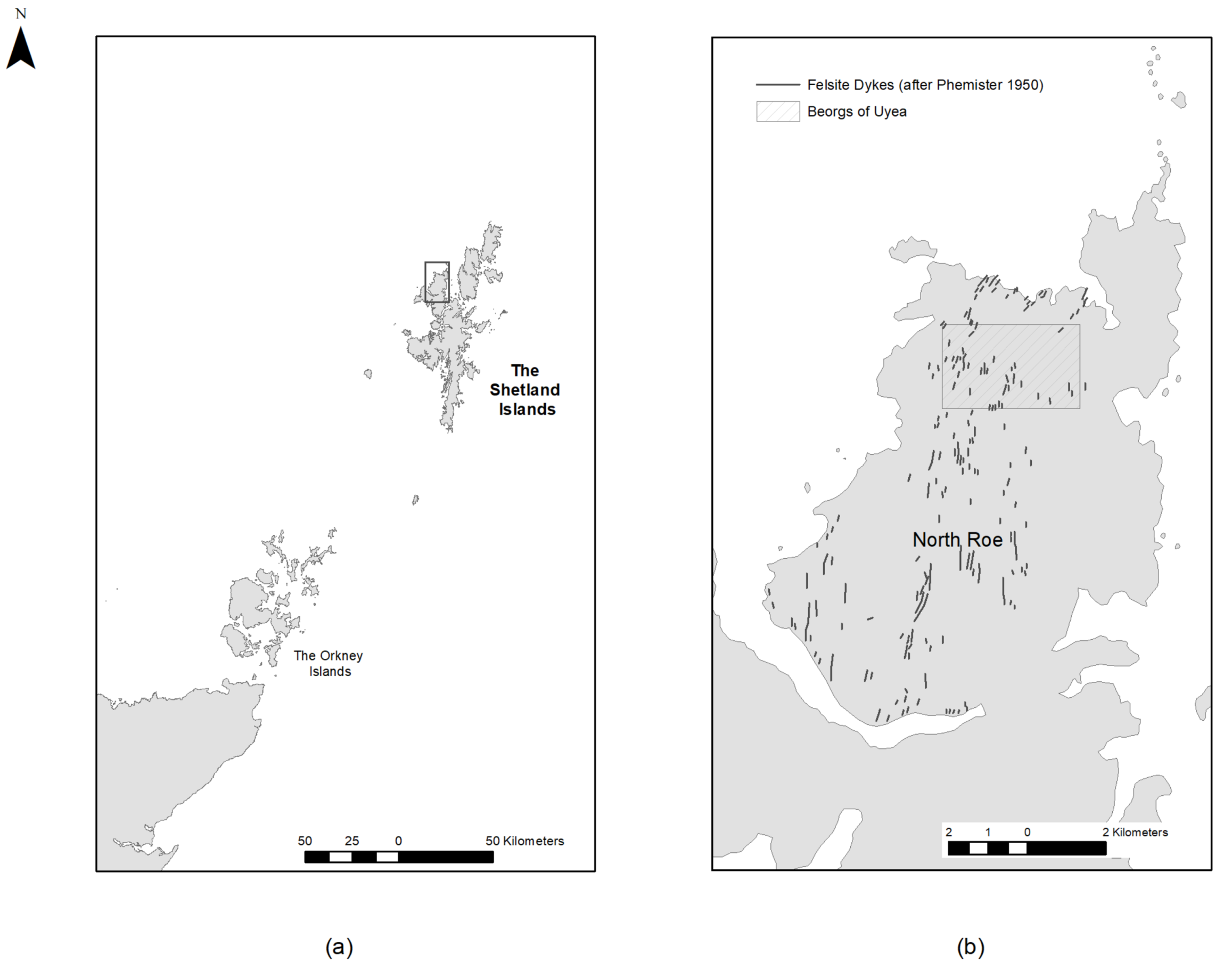
The Shetland Islands lie 160 kilometres north of mainland Scotland. Situated northeast of Orkney and west of Norway, the islands are rich in prehistoric and Viking archaeology (Figure 1). As the northernmost part of Europe where farming was practiced during the Neolithic (3800–2500 BC), it has been the subject of a number of recent projects including the Northern Worlds Project by the National Museum of Denmark [1,2] and the North Roe Felsite Project (NRFP), a research project exploring the extraction, manufacture and distribution of Neolithic polished stone tools [3,4,5]. During the Neolithic period, a distinctive blue-grey rock called (riebeckite) felsite was used to manufacture ground and polished stone axes and knives which are found throughout the Shetland archipelago but apparently not further afield. This rock was quarried from north-south running felsite dykes on the slopes and the area north of Ronas Hill, Northmavine, the highest point on the islands. The isolated location of these quarry complexes has resulted in the exceptional preservation of material with artefacts, debitage and knapping episodes clearly identifiable on the surface. The quarry sites offer an insight into the extraction and initial stages of the production of stone tools at a unique resolution, while the distribution of the ground and polished artefacts across the archipelago is an interesting example of an insular distribution network in a closed economy [6].
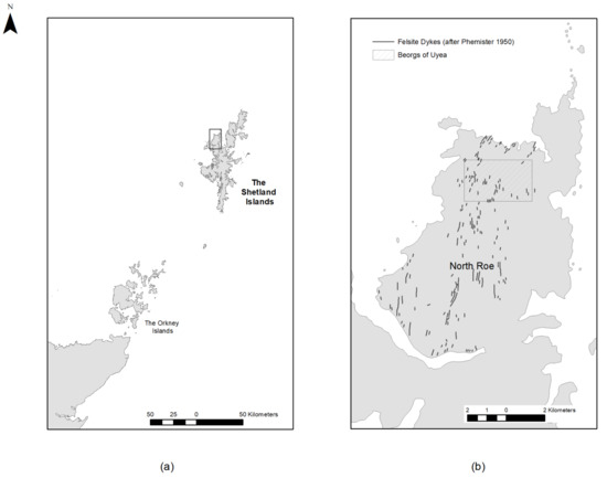
Figure 1.
(a) Northern Scotland, the Shetland Islands, (b) North Roe, Northmavine with felsite dykes and the quarry site at the Beorgs of Uyea indicated (Image by the Authors).
1.2. The North Roe Felsite Project (NRFP)
Quarry sites are situated along felsite dykes which are oriented north-south over a 60 km2 region of Northmavine called North Roe. The North Roe quarry complex occurs in and because of a particular geological situation where a series of dykes, predominantly of (riebeckite) felsite have intruded into what is known as the Northmavine pluton. The bedrock is referred to as Ronas Hill granite, a pinkish white granophyritic granitic rock. They occur both across the northern margin of the batholith (referred to as the Beorgs of Uyea area) as well as across the central exposures of the Ronas Hill granite outcrop [7]. Phemister et al. [8] mapped the dyke complex (Figure 1b), and noted that axes and knives (known as Shetland knives) from the suite of reibeckite felsite dykes had been found throughout Shetland but suggested that the dykes at North Roe had not been quarried because of their remoteness. Ritchie [9,10,11] provided the first archaeological assessment of the quarry and the axes and knives from it, now recognised as the source for Group XXII (reibeckite felsite) in the British scheme for the petrological grouping of stone axes. The best known area of the quarry complex with the highest concentration of felsite dykes which were worked is at the Beorgs of Uyea (Figure 2).
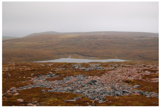
Figure 2.
Quarry site at Uyea, North Roe (Image from the NRFP 2013).
Between 2013 and 2017, the NRFP has investigated quarrying processes at landscape, regional and individual site scales using a range of techniques and approaches. Compiling an initial inventory of sites within the North Roe quarry complex was challenging in such a large and remote area where standard field survey is often impacted by adverse weather. Phemister’s original geological map of dyke locations made it often difficult to identify the dykes on-the-ground while other dykes were located through survey work (Figure 1) [8]. A survey efficacy model was created to address this issue using Worldview-2 multi-spectral satellite imagery and least-cost modelling approaches [12]. Known sites were used to train a classifier to identify all felsite in the region. The posterior probabilities produced by the classifier were then combined with a least-cost model from access points to create a hybrid model which was used to target survey efforts. Results were very positive, primarily due to the direct correlation between felsite and quarry sites, and the clear spectral differentiation between felsite and the surrounding bedrock. Weightings from principal components generated during the study indicated that the visible blue and red spectra were the most valuable during the classification process, suggesting the potential utility of standard imagery captured at a higher resolution. These results form the basis for this study.
Following identification, focus shifted to understanding the quarrying processes at individual sites. These were focused on three distinct areas of quarrying at Midfield, Grutt Wells and The Beorgs of Uyea, which are the subject of this study. The NRFP study of quarrying and production processes at sites builds on the work of Ballin [6,13] who applied Schneiderman-Fox and Pappalardo’s [13] terminology to characterize the evidence for Neolithic quarrying at the quarry complex. This recognizes four different categories of activity area and debitage; quarries, tailing piles (places adjacent to quarry faces containing blocks of quarried material), transition areas and lithic reduction sites or workshops. There is considerable overlap of material in these categories at North Roe, which is initially best understood as a combination of shifting and accumulating foci of different activities over time. A number of other approaches were adopted in the NRFP to assist in the characterization of activities at the quarries for the production of stone axes and related objects. In terms of ranking the importance of quarries, one approach is to establish the extent of outcrops, the nature of the raw material and the ease with which it could be extracted [14,15]. Weisler [16] suggests that the relative size of quarries can be estimated from measuring the extent of exposed debitage and the overall site area, determining the density of debitage, including areas of concentration, and quantifying the number of hammerstones, blanks and preforms at each quarry. In establishing a methodology for their work at Great Langdale, Cumbria, the largest source (Group VI tuff) for stone axes in Britain, Bradley and Edmonds [14] emphasized the need to understand the process of stone tool making as ‘a sequence of decisions and actions, choices that are made concerning the steps that can be taken in creating a particular artifact’ and the importance of not losing sight of this perspective in thinking in terms of reduction sequences. At the same time when dealing with fine-grained lithic sources which are conducive to flaking and where stages in the reduction sequence can be recognised, the chaine opératoire approach has been widely used as a methodological framework to reconstruct quarrying and reduction processes [5]. Referring back to Bradley and Edmonds [14], their approach involved a detailed survey and analysis of surface material facilitated by a programme of experimental knapping followed by selective excavation to provide stratified contexts and potentially a chronology to deepen understanding of the process and the character of stone working. This has informed and provided a comparative model for the approach taken at the North Roe quarry complex which is discussed below. In essence, early stage quarrying and roughing out produces larger waste material of varying shapes. As the production sequence progresses, the debitage material becomes smaller and more uniform. As such, a low proportion of small uniform flakes would suggest earlier stages, while a very high percentage of such material would indicate a much later stage of production.
2. Materials and Methods
2.1. Survey, Dyke and Debitage Field Characterisation
Intrasite field survey was undertaken using a Trimble 5800 survey grade global navigation satellite system (GNSS), in a rover and base station configuration. Modern digital survey is now often facilitated using real time correction provided via a range of services accessed through a mobile internet connection. This facilitates an instrument precision, in the field, in real time, of approximately 1 cm in easting and northing and 2 cm in elevation in the chosen grid system. Unfortunately, mobile signal at the Beorgs of Uyea site at the time of the survey was unreliable or non-existent. Consequently, a semi-permanent base station point was set up and fixed to the British National Grid to within approximately 2 m, with the aim of post-processing the survey to a more precise fix after it had been completed, using RINEX files. However, at the time of the survey all the collected data were precise to 1 cm in easting and northing and 2 cm in elevation relative to that base station location.
Sites often contained evidence for extraction at multiple nonhomogeneous felsite dykes. The appearance of these dykes can vary considerably, not only between dykes, but also along their lengths and widths. As such, they can have a homogeneous blue or blue/grey colour, speckles of pinkish feldspar phenocrysts, parallel banding, and small to large spherulitic inclusions. Similarly, the colour of this material can range from deep blue to green toward almost white due to leaching caused by the acidic surface water of the bog [17,18]. A field characterisation survey at the Beorgs of Uyea sought to record variations between exposures found over the site and to identify the potential sources of raw materials for stone tool artefacts. Dykes were characterized across their width and the accompanying debitage at regular intervals. Each section of a characterized dyke was given a number to identify it, in addition to its dyke letter. While the wider landscape survey followed an alternate convention [17], for the intrasite survey dykes were labelled (A through G) and surveyed by archaeologists with experience of prehistoric lithics and quarries/quarrying: Bernard Gilhooley, Brendan O’Neill, Jostein Gunderson and Astrid Nyland. This group approach provided a useful platform for debate where unanimous consensus could not be reached. A survey of non in-situ surface material was included to assess the relationships between spreads of different types of felsite and whether there had been any significant movement over time. As each section of a dyke was inspected, its petrographic type was recorded, its global positioning system (GPS) coordinates logged, and a detailed written description of the area made. A photographic record of both dyke and debitage using a 1 m square was also carried out for all major debitage concentrations and was subsequently digitized. Felsite variants and condition were noted, as were the stages of production present, based on the morphology and size of the debitage and, in particular, the quantities of both as percentages. This also provided a better understanding of where different activities were taking place on the site, and how stages of production may have been spatially separated. While this level of detail was possible on a small scale, it was too time-consuming to undertake across the entire site. In total, 59 one-metre square boxes were sampled from across the site. A survey of all visible surface artefacts was also undertaken, including roughouts, cores, wedges and hammerstones.
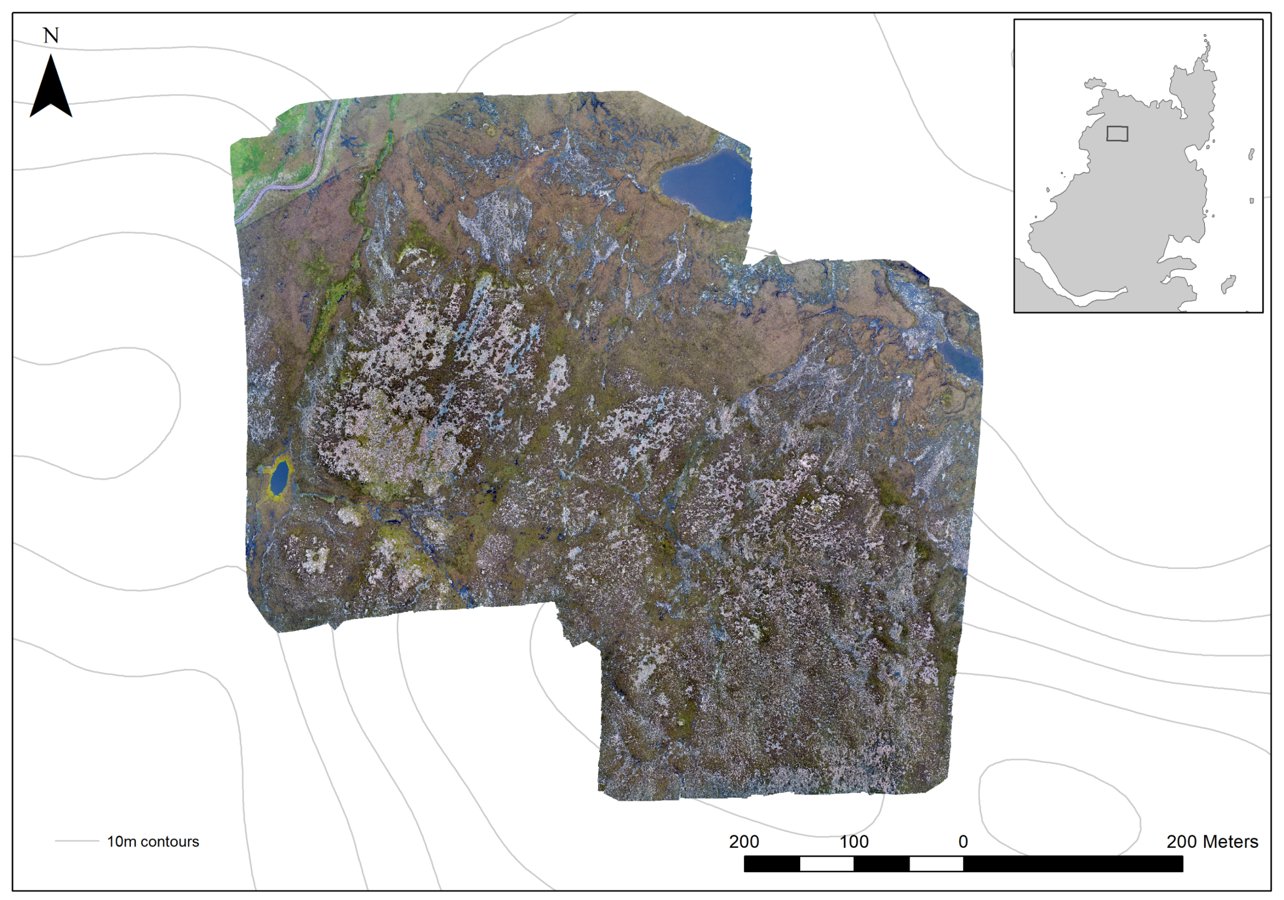
Given the time-consuming nature of field-characterisation, a semi-automated remote approach for extent classification using three band imagery (red, green, blue), and a material characterisation based on rugosity derived from a structure-from-motion (SfM) elevation model was developed. The imagery was captured in May 2017 during two unmanned aerial vehicle (UAV) flights using a DJI Inspire 2 on a pre-set flight path over the Beorgs of Uyea quarry site (Canmore site number HU39SW 2). This site was chosen as the surface material present represents the most complex example of stone tool quarrying in Shetland. Flight plans were automatically programmed (Pix4Capture App) to an elevation of 80 m Above Ground Level (AGM). This height relates to the ground elevation at take-off, and given that our survey area is a slope and the majority of the take-off locations were located at the top of the slope, AGL will increase toward the north of the study area, down slope. We calculate that the maximum AGL to the northern extents of the flight lines are c.120 m–150 m AGL. The majority of the analysed lithic work areas were flown at 80 m AGL. In total 376 images were captured with a 75% overlap. Given the size, terrain and restricted weather windows at the time of the survey, temporary ground control points were not physically placed during the UAV flights (e.g., checker boards) nor were high visibility marker paints used. Unique natural geological, geomorphological and weathered rock features were identified randomly across the extent of the site, surveyed using Realtime Kinematic GNSS techniques and connected to a local grid and datum (OSGB). Geotagged digital ground images were collected at each natural ground control points (GCP) including multiple view angles at the time of observation to aid later spatial and temporal identification of GCP locations. Given the high ground sample distance expected during the survey and the abundance of differentially coloured weathered and fractured geology on site, 25 GCPs were GNSS surveyed across the site and identified during an SfM georeferencing process. An IBM generated georeferenced 3D surface model was generated using an SfM pipeline. This was used to create orthoimagery covering an area of 335,000 m2 with a spatial resolution of 1.5 cm and an 8-bit pixel depth (Figure 3).

Figure 3.
The extent of unmanned aerial vehicle captured orthoimage at The Beorgs of Uyea (Image by the Authors).
2.2. UAV Survey, Image Classification and Assessment
Campana [19] has recently written extensively on UAV use in archaeology with a particular focus on practical considerations, sensors and data processing, stressing the benefits of UAV systems, specifically their cost, accuracy and control of data capture. The flexibility of UAV systems, in particular their utility when used alongside other datasets as part of more complex and targeted research projects, has been visible in a range of recent projects including Sonnemann et al.’s [20,21] study of Amerindian settlement patterns and social structures, and Jorayev et al.’s [22] recording of the Olduvai landscape. Both projects illustrated the utility of UAV platforms in remote and difficult-to-reach areas where other data sources or techniques were not available. UAV platforms have also been used to monitor looting [23] and to record extant monuments [24]. The flexibility and affordability of UAV platforms should be set alongside their limitations. They can struggle in higher winds, which is a common issue in the Shetland Islands. The captured data is limited to visible and infrared imagery, and while active sensing platforms are now available they are very expensive. The vast majority of archaeological UAV projects have focused on the generation of image-based modelling-derived 3-dimensional surfaces generated using a structure-from-motion (SfM) pipeline. This paper is interested in the value of the data itself rather than its visualization. There are precedents in ecology where Mafanya et al. [25], and Lu and He [26], have used high spatial resolution UAV imagery to classify heterogeneous ecosystems. These studies recorded producer accuracies of 86% and 85% respectively, indicating the efficacy of the approach.
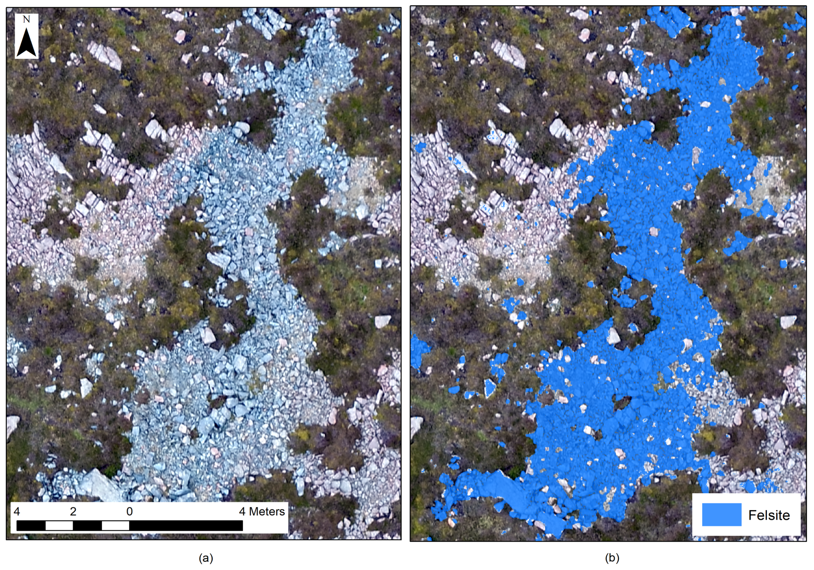
The extent of the quarrying activity at Uyea is manifest in the distribution of felsite across the site. Fortunately, the clear visual differentiation between felsite and the granite into which the dykes were intruded is conducive to semi-automated classification, facilitating the automated extraction of archaeological activity. Training data, collected using the GNSS, was used to generate a maximum likelihood classification of the orthoimage. The image was classified into five classes: felsite, grass, heather, granite and water. While primarily interested in felsite, multiple classes were characterised to assess model accuracy, specifically confounding between similar classes. The classification was assessed using a confusion matrix generated from known points across the quarry site and within the orthoimage. 50 points were recorded for each class, totaling 250 known points. Producer’s accuracy and kappa statistics were generated to assess the classification. These are presented in Table 1. The felsite could then be extracted and the debitage extents explored (Figure 4).

Table 1.
Classification Accuracy Assessment for Maximum Likelihood Classifier.
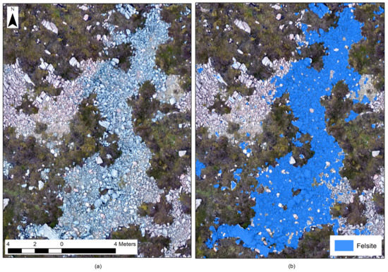
Figure 4.
(a) Felsite debitage spread and (b) classified image (Image by the Authors).
2.3. Terrain Analysis and Rugosity
High-resolution terrain models record small variations in the topography of the landscape. At a landscape scale, surface models derived from airborne laser scanning (ALS) are capable of recording topological features including extant monuments and sites with very slight topographic signatures. These have been extensively used for archaeological site prospection (see papers in Opitz and Cowley) [27]. At the other end of the spectrum, 3D scanning using desktop and terrestrial laser scanning have been used to capture surface features on monuments and minute microware patterns on artefacts [28]. Such tools have been used to explore surface rockiness before [29], but while they are highly effective, both techniques are expensive when compared to the models derived using UAV imagery and an SfM pipeline.
While image classification would prove to be a highly effective way to automate the extraction of information about the extent of past extraction activities, it cannot provide information on the character of the debitage itself. As discussed in Section 1.2, quarrying produces different morphologies and sizes of debitage, and the distribution of this material can tell us much about the extraction processes. The high resolution of the imagery captured by the UAV records individual objects on site, but digitising all individual pieces of material would be impossibly time-consuming, and the results would be limited by the resolution of the imagery. In this study, rugosity is explored as a proxy for archaeological activity. The quarrying process at The Beorgs of Uyea generated debitage of different sizes from large boulders to tiny flakes, and these sizes reflect different processing in the production process. This material changed the structure and texture of the ground surface, and it was hoped that the rugosity might capture these changes at a useful scale. The rugosity (f r) records the ruggedness of surfaces and can be shown as:
where Ar is the true or real surface and Ag is the geometric surface. Using this approach, the more rock faces present, the greater the rugosity, suggesting that parts of the site with more debitage should have higher values than those with lower quantities. The rugosity values were calculated for felsite extents as classified in the surface classification. The rugosity was calculated at a cell by cell resolution for the entire site, which was then clipped to only include felsite as classified using the drone imagery. In order to extrapolate this data for the entire site, a 0.50 m mean filter was used. This identified areas of small and large debitage (Figure 5). Accuracy assessments are discussed in the next section.
f r = Ar|Ag
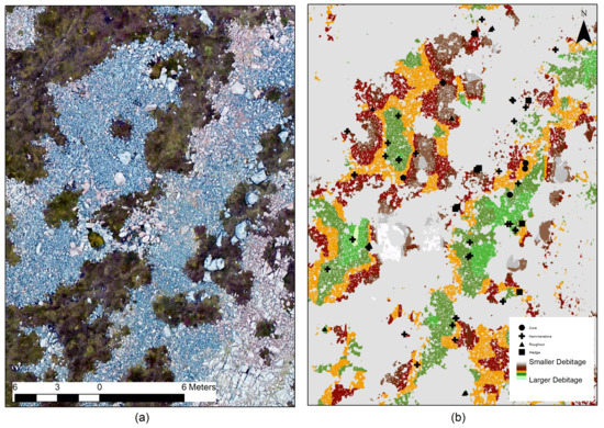
Figure 5.
(a) Orthoimage of dykes b and c, and (b) mean rugosity index classified based on quantile values showing smaller values at the margins of debitage extents, and artefact locations along dykes (Image by the authors).
3. Results
3.1. Image Classification and Assessment
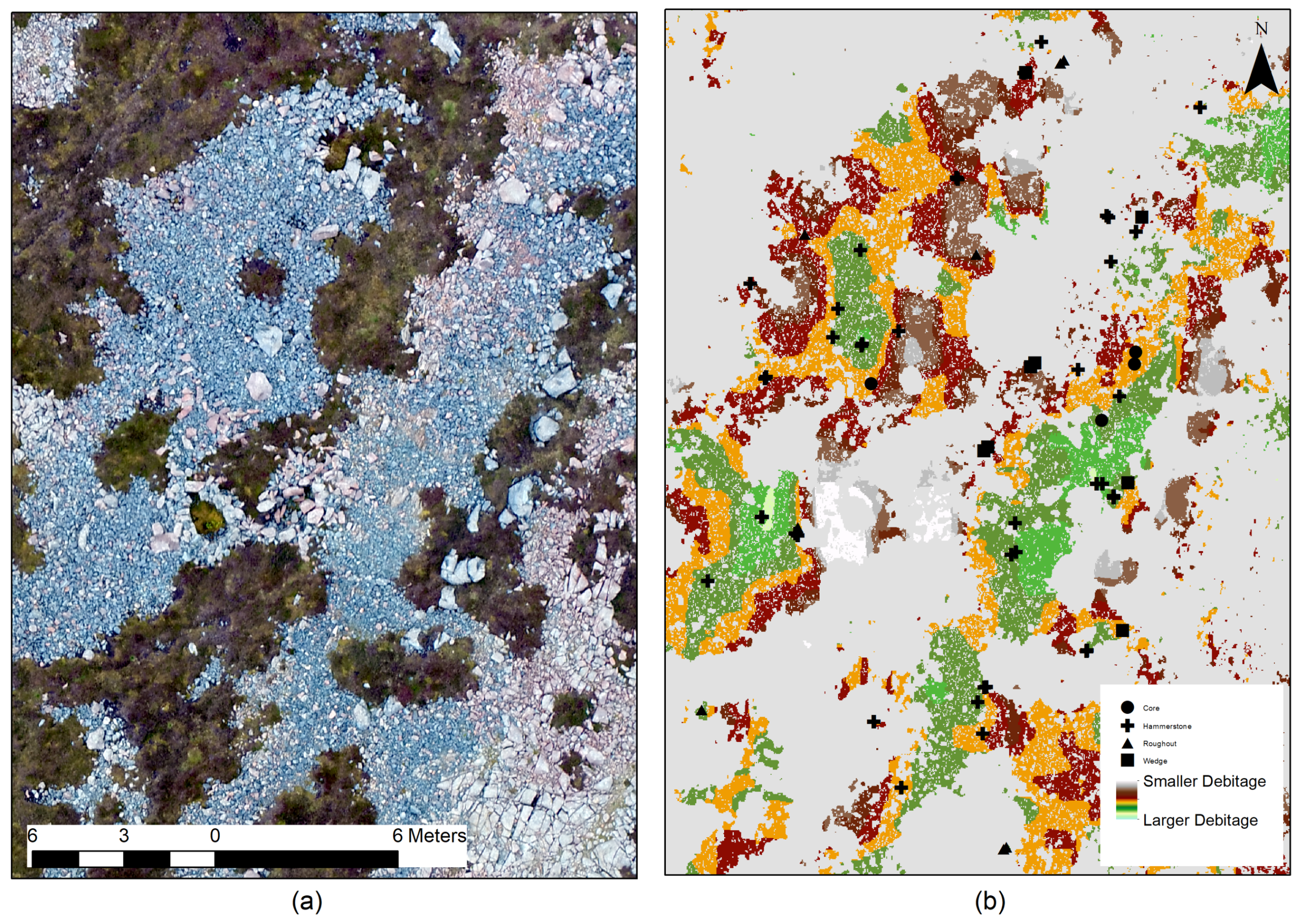
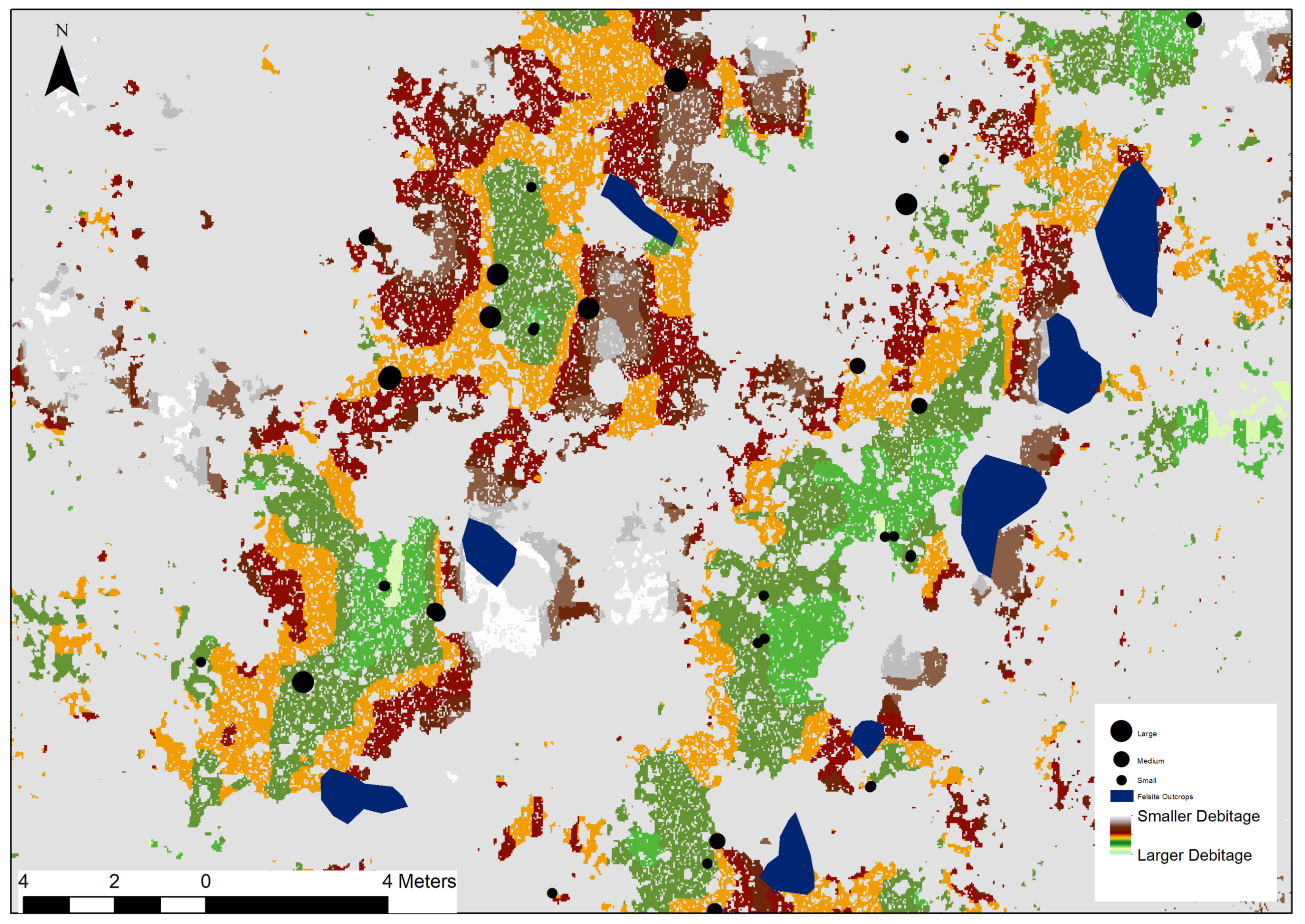
Previous studies [12] have suggested that felsite is best differentiated from the surrounding bedrock using visible red, green and blue (RGB) imagery. Image classification using imagery captured using UAV proved to be a very effective way to remotely classify the extent of the quarry (Figure 4). The accuracy assessment for the felsite classification returned a Producer’s Accuracy and Kappa Statistic of 96% and 0.8611 (Table 1), respectively. There is some confounding between classes, specifically between felsite and water, and between felsite and granite. The former is unsurprising given the similar colour spectra while the latter most likely reflects bleaching caused by the acidification of the bog. A total area of 0.34 km2 was classified with a cell resolution of 1.5 cm. The percentages of classifications were felsite (7.3%), grass (16.3%), heather (49.9%), red granite (24.3%) and water (2.2%). This classification allows for the accurate identification of activity at the sites and, following Schneiderman-Fox and Pappalardo’s [13] characterisation of activities, it allows for the recording of the tailing piles alongside the quarry or dyke faces, and the lithic reduction or workshop areas where material was further processed into a roughout state. It can also allow us to better understand the size of the site using Weisler’s [16] model, which uses a combination of material extent, activity as defined by rugosity (see below) and artefact distributions. The total extent of both datasets is 75,223 m2 (Figure 6).
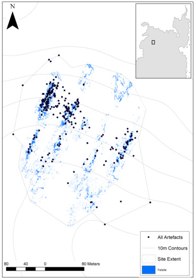
Figure 6.
Site extent based on felsite classification and artefact distribution (Image by the authors).
3.2. Rugosity and Material Characterisation
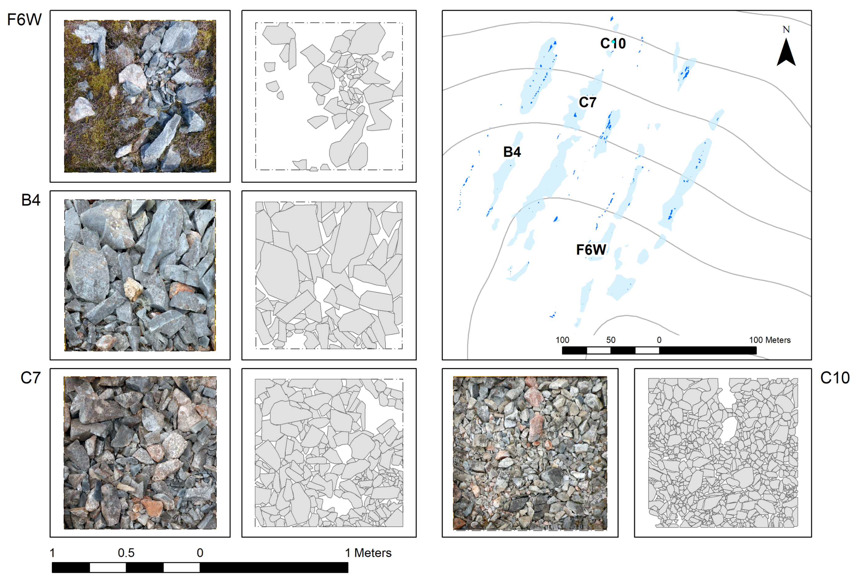
The efficacy of the rugosity model to capture material size was assessed using the sample field characterisation of the site discussed in Section 2.1. This included georeferenced 1 × 1 m plans digitised from survey photographs. The extent of the debitage in each square was not consistent, so the percentage of felsite coverage in each square was calculated based on the above classification. This ranged from 1% to 94%. The efficacy of the remote characterisation based on rugosity was assessed using a sample of these squares (Figure 7). Field notes were used to identify four squares with different size material, and the mean rugosity was calculated within each square (Table 2). These ranged between 0.0081975 and 0.0168225.
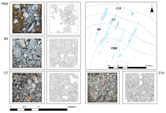
Figure 7.
The felsite characterisation survey showing the debitage size (Image by the Authors).
Table 2.
Debitage Statistics from Plans and Rugosity Values.
As discussed in Section 1.2, stone tool production sites have been characterised using a range of different approaches including debitage extent, location, size and its association with artefacts. Figure 7 and Table 2 display and record the size and extent of the debitage in four sample areas, as well as their rugosity statistics. There is a relationship between the percentage of debitage cover, the mean size of debitage material and the mean rugosity in the sample area. While the rugosity index is effective in recording the texture of large and medium sized debitage (F6W and B4), it is less effective with smaller material (c.0.3–0.15 cm2) (C7 and C10). This is to be expected due to the resolution of the model.
3.3. Classification, Characterisation and Artefacts
Weisler [16] has suggested that sites can be best understood by exploring material extent, concentrations and the location of tools including hammerstones, blanks and preforms at each quarry. While the survey at the Beorgs of Uyea site recorded different types of artefacts, those surveyed in the felsite extents can be explored in relation to rugosity. In Figure 5, rugosity values have been binned based on minimum and maximum values and the mean values in Table 2. A visual analysis of the distribution suggests that the majority of artefacts are in areas near the dyke quarry faces. A more detailed study of hammerstones plotted by size (small, medium and large) is presented in Figure 8. While smaller hammerstones are found throughout the site, larger ones are in areas of bigger material. Table 3 records statistics for the four artefact types. In total, 121 artefacts were surveyed within the extents of the felsite debitage. Mean rugosity values suggest that other artefacts tend to be found in areas of smaller debitage; however, it should be stressed that the range of values is quite high, indicating a wide spread across debitage sizes.
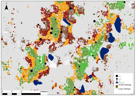
Figure 8.
Hammerstone sizes and rugosity.
Table 3.
Debitage Statistics from Plans and Rugosity Values.
4. Discussion
Quarry sites can be understood based on a number of activities and factors. To use Schneiderman-Fox and Pappalardo’s terms, the sites in North Roe are best understood as an example of a quarry where we can see all stages of work from when material was extracted from felsite dykes (quarries, tailing piles) and worked into roughouts (transition and lithic reduction areas). There is abundant evidence for these processes are visible on the ground, but it can be difficult to differentiate them and map them over such a large area. This study has proposed that our understanding of the quarry complex can be advanced by recognising that some characterisation factors can be assessed remotely using high-resolution UAV orthoimagery and derived elevation models. The imagery collected using UAV platforms has been shown to be highly effective in remotely classifying the extent of felsite debitage at the Beorgs of Uyea site (Table 1). This is undoubtedly due to the clear spectral differentiation between felsite and the red granite country rock, so it is questionable how effective the approach would be at other sites. While highly effective, there are still errors, notably false positive results where water shares a similar spectral value to felsite. Nonetheless, it does allow us to explore the size of the Beorgs of Uyea part of the complex using Weisler’s [16] method of combining artefact distributions with debitage extents (Figure 6).
The macroscopic appearance of felsite can vary significantly and dyke exposures were characterised visually in the field. This task requires a human eye and was beyond the scope or resolution of the UAV imagery. It was possible to explore the size of the material as a proxy for quarrying activity. As discussed in the opening section, Bradley and Edmonds [14] note the importance of determining the sequence and process of production where early phases produce larger material, and where later more precise work produces smaller debitage, as well as debitage of varying morphology. While rugosity does not capture the morphology per se, this process of working material from quarry to roughout, is visible in the pattern of decreasing material size toward the margins of the debitage (Figure 5). Using data collected during field survey, it was possible to assess the model, comparing the values with the mean debitage sizes recorded from the plans. The results from this analysis are less conclusive than the image classification, as the model struggles to differentiate morphological classes of smaller debitage due to the resolution of the elevation model (Table 2). The results suggest that a greater resolution imagery would provide better results. This would likely be achievable using a higher resolution camera or reducing the flight level of the UAV; however, such an approach would also significantly increase the processing requirements of the dataset at larger sites. In spite of these limitations, the rugosity analysis is a valuable tool for more targeted field research. At large sites, where survey resources may be limited, sampling strategies would be significantly improved using the rugosity characterisation model.
The archaeological integrity and authenticity of the site is suggested by the artefact distributions. Larger hammerstones are found closer to quarry faces in areas of large to medium debitage, while smaller artefacts like roughouts are found in areas of small to medium material (Table 3). This also confirms the efficacy of the model in remotely capturing and categorising felsite.
This is not the first study to explore the wider applications of UAV imagery derivatives, but it further illustrates the value of taking a more expansive approach. Basic image processing techniques like image classification are not limited to multispectral platforms and, in the right conditions, could have wide-ranging applications on sites where detailed mapping is required over large areas. These would undoubtedly be better suited to sites where there is a clear spectral distinction between archaeological features and the background landscape, but their utility as decision support tools should not be underestimated at other sites. Nor is the value of such an approach limited to rugosity. Many tools developed for exploring elevation datasets can be (and have been) similarly applied to models derived from UAV images using a IBM pipeline (see for examples English Heritage 2017 [30]). The complexity of many sites always requires a critical application, but the utility of UAV captured data as a low-cost and flexible alternative to aerial and terrestrial laser scanning is clear.
5. Conclusions
Quarry sites can be explored through the study of material extent and morphology, and on the distribution of artefacts. The protocols presented here indicate the efficacy of remote and automated image classification for the differentiation of felsite extents from background geology and other land classes (Figure 4). While there is some confusion between the classes, the producer’s accuracy and kappa statistics presented in Table 1 are clear. Remotely classifying morphology is more complex. Rugosity derived from the elevation data was used as a proxy to explore activities at the quarry sites based on material size. This was effective in characterising large and medium pieces of felsite, but the spatial resolution of the model restricted its application to smaller material (Table 2). It was successful in showing how larger material was located closer to the quarry face, while smaller material was further away (Figure 5). The location of artefacts further supported this result while also indicating the exceptional degree of preservation at the site (Table 3 and Figure 8). It should be stressed that elevation derivatives like rugosity should not be considered as substitutes for the actual characterisation of morphology which requires a field-based assessment. Rather, they can be used as proxies to explore general patterns and to support more strategic investigations at larger sites.
The benefits of low-cost UAV-captured imagery are well known. They have revolutionised the way in which archaeologists can explore sites and landscapes. The utility of such imagery in the classification and characterisation of Neolithic felsite stone tool quarry sites has been presented in this paper, which has focused on the Beorgs of Uyea quarry site, part of a larger Neolithic quarry complex at North Roe, The Shetland Islands. The time and resource saving impact of this approach allows for the better understanding of the site, both in terms of the critical task of mapping past quarrying activity and to understand the extraction processes when used alongside artefact distributions. While some factors remain specific to this study, the wider application of such an approach should be considered, not just at Neolithic quarry sites, but in any study where the mapping of features is restricted by scale or resources.
Acknowledgments
The authors acknowledge the financial support of the National Geographic Global Exploration Fund (Northern Europe) Grant Numbers; GEFNE54-12; GEFNE 147-15. The Culture and Society Cluster at Queen’s University Belfast and UCD College of Social Sciences and Law and the UCD School of Archaeology at University College Dublin also provided financial support. Thanks also to the North Roe Felsite Project (NRFP) team members over the years including Torben Ballin, David Field, Joanne Gaffney, Jostein Gunderson, Niamh Kelly, Mik Markham, Alison Sheridan, Pete Topping and the late Vin Davis. Support was always available from the staff at the Shetland Museum and Archives, especially Jenny Murray. Local support was also provided by Val Turner (Shetland Archaeologist, Shetland Amenity Trust. We would also like to acknowledge and thank Archaeology Shetland for their contribution to the project.
Author Contributions
William Megarry wrote the majority of the article, performed the image processing including the classification, terrain analysis and validation. Conor Graham authored sections on UAV, piloted the UAV and undertook some of the image based processing. Bernard Gilhooly, Astrid Nyland and Brendan O’Neill defined the surface characterisation techniques and undertook the field mapping. Rob Sands collected ground truth data using RTK GPS. Gabriel Cooney is the PI on the NRFP. All authors were involved in the writing and refining of the article text.
Conflicts of Interest
The authors declare no conflict of interest.
References
- Mahler, D.L.; Andersen, C. Farming on the Edge: Cultural Landscapes of the North: Short Papers from the Network Meeting in Lerwick, Shetland September 7th—10th 2010; Nationalmuseet: Copenhagen, Denmark, 2011; Available online: http://nordligeverdener.natmus.dk/fileadmin/site_upload/nordlige_verdener/pdf/Farming_on_the_edge_rapport_web.pdf (accessed on 1 November 2017).
- Mahler, D.L. The Border of Farming and the Cultural Markers: Short Papers from the Network Meeting in Lerwick, Shetland, September 5th—9th 2011; Nationalmuseet: Copenhagen, Denmark, 2012; Available online: http://nordligeverdener.natmus.dk/fileadmin/user_upload/temasites/nordlige_verdener/nordlige_verdener/Ditlev_L_Mahler/The_Border_of_Farming.pdf (accessed on 1 November 2017).
- Cooney, G.; Ballin, T.; Davis, V.; Sheridan, A.; Megarry, W. Making an Island World: Neolithic Shetland; 2013 Field Season Report; UCD School of Archaeology: Dublin, Ireland, 2013. [Google Scholar]
- Cooney, G.; Ballin, T.; Davis, V.; Sheridan, A.; Megarry, W. Making an Island World: Neolithic Shetland; 2014 Field Season Report; UCD School of Archaeology: Dublin, Ireland, 2014. [Google Scholar]
- Cooney, G. The Role of Stone in Island Societies in Neolithic Atlantic Europe: Creating Places and Cultural Landscapes. Arct. Inst. N. Am. 2017, 69, 1–12. [Google Scholar] [CrossRef]
- Ballin, T.B. Felsite axehead reduction—The flow from quarry pit to discard/deposition. In The Border of Farming Shetland and Scandinavia: Neolithic and Bronze Age Farming—Short Papers from the Symposium in Copenhagen, September 19th—21th 2012; Mahler, D.L.D., Ed.; Nationalmuseet: Copenhagen, Denmark, 2013; pp. 73–92. [Google Scholar]
- Davis, R.V. A Preliminary Report on the Petrographic Survey of the Neolithic Stone Quarries and Stone Tool Manufacturing Sites at North Roe, Shetland, 2012; unpublished.
- Phemister, J.; Harvey, C.O.; Sabine, P.A. The riebeckite-bearing dykes of Shetland. Mineral. Mag. 1950, 29, 359–373. [Google Scholar] [CrossRef]
- Ritchie, P.R. The stone implement trade in third millennium Scotland. In Studies in Ancient Europe; Coles, J.M., Simpson, D.D.A., Eds.; Leicester University Press: Leicester, UK, 1968; pp. 117–136. [Google Scholar]
- Ritchie, P.R.; Scott, J.G. The petrological identification of stone axes from Scotland. In Stone Axe Studies 2; Clough, T.H., Cummins, W.A., Eds.; The Council for British Archaeology: London, UK, 1988; pp. 85–91. [Google Scholar]
- Ritchie, R. Stone axeheads and cushion maceheads from Orkney and Shetland: Some similarities and contrasts. In Vessels for the Ancestors: Essays on the Neolithic of Britain and Ireland in Honour of Audrey Henshall; Sharples, N.M., Sheridan, J.A., Eds.; Edinburgh University Press: Edinburgh, UK, 1992; pp. 213–220. [Google Scholar]
- Megarry, W.P.; Cooney, G.; Comer, D.C.; Priebe, C.E. Posterior Probability Modeling and Image Classification for Archaeological Site Prospection: Building a Survey Efficacy Model for Identifying Neolithic Felsite Workshops in the Shetland Islands. Remote Sens. 2016, 8, 529. [Google Scholar] [CrossRef]
- Schneiderman-Fox, F.; Pappalardo, A.M. A paperless approach toward field data collection: An example from the Bronx. SAA Bull. 1996, 14, 1–18. [Google Scholar]
- Bradley, R.; Edmonds, M. Interpreting the Axe Trade: Production and Exchange in Neolithic Britain; Cambridge University Press: Cambridge, UK, 1993; p. 252. [Google Scholar]
- Torrence, R. Production and Exchange of Stone Tools: Prehistoric Obsidian in the Aegean; Cambridge University Press: Cambridge, UK, 1986. [Google Scholar]
- Weisler, M. A quarried landscape in the Hawaiian Islands. World Archaeol. 2011, 43, 298–317. [Google Scholar] [CrossRef]
- Markham, M.; Davis, R.V. The Petrology of Shetland Felsite Stone Axes, 2017; unpublished.
- O’Neill, B.; Gilhooly, B.; Cooney, G. Stone Tools of Shetland: Experimental Felsite Project. 2014. Available online: https://exarc.net/issue-2014-3/ea/stone-tools-shetland-experimental-felsite-project (accessed on 1 December 2017).
- Campana, S. Drones in Archaeology. State-of-the-art and Future Perspectives. Archaeol. Prospect. 2017, 24, 275–296. [Google Scholar] [CrossRef]
- Sonnemann, T.F.; Malatesta, E.H.; Hofman, C.L. Applying UAS Photogrammetry to Analyze Spatial Patterns of Indigenous Settlement Sites in the Northern Dominican Republic. In Digital Methods and Remote Sensing in Archaeology. Quantitative Methods in the Humanities and Social Sciences; Springer: Cham, Switzerland, 2016; pp. 71–87. [Google Scholar]
- Sonnemann, T.F.; Ulloa Hung, J.; Hofman, C.L. Mapping Indigenous Settlement Topography in the Caribbean Using Drones. Remote Sens. 2016, 8, 791. [Google Scholar] [CrossRef]
- Jorayev, G.; Wehr, K.; Benito-Calvo, A.; Njau, J.; de la Torre, I. Imaging and photogrammetry models of Olduvai Gorge (Tanzania) by Unmanned Aerial Vehicles: A high-resolution digital database for research and conservation of Early Stone Age Sites. J. Archaeol. Sci. 2016, 75, 40–65. [Google Scholar] [CrossRef]
- Kersel, M.M.; Hill, A.C. Aerial Innovations: Using Drones to Document Looting. Orient. Inst. News Notes 2015, 224, 4–7. [Google Scholar]
- Murtiyoso, A.; Grussenmeyer, P. Documentation of heritage buildings using close-range UAV images: Dense matching issues, comparison and case studies. Photogramm. Rec. 2017, 32, 206–229. [Google Scholar] [CrossRef]
- Mafanya, M.; Tsele, P.; Botai, J.; Manyama, P.; Swart, B.; Monate, T. Evaluating pixel and object based image classification techniques for mapping plant invasions from UAV derived aerial imagery: Harrisia pomanensis as a case study. ISPRS J. Photogramm. Remote Sens. 2017, 129 (Suppl. C), 1–11. [Google Scholar] [CrossRef]
- Lu, B.; He, Y. Species classification using Unmanned Aerial Vehicle (UAV)-acquired high spatial resolution imagery in a heterogeneous grassland. ISPRS J. Photogramm. Remote Sens. 2017, 128 (Suppl. C), 73–85. [Google Scholar] [CrossRef]
- Opitz, R.S.; Cowley, D. Interpreting Archaeological Topography: Airborne Laser Scanning, 3D Data and Ground Observation; Oxbow: London, UK, 2013. [Google Scholar]
- Molloy, B.; Wisniewski, M.; Lynam, F.; O’Neill, B.; O’Sullivan, A.; Peatfield, A. Tracing edges: A consideration of the applications of 3D modelling for metalwork wear analysis on Bronze Age bladed artefacts. J. Archaeol. Sci. 2016, 76, 79–87. [Google Scholar] [CrossRef]
- Nevalainen, P.; Middleton, M.; Sutinen, R.; Heikkonen, J.; Pahikkala, T. Detecting Terrain Stoniness from Airborne Laser Scanning Data. Remote Sens. 2016, 8, 720. [Google Scholar] [CrossRef]
- Historic England. Photogrammetric Applications for Cultural Heritage. In Guidance for Good Practice; Historic England: Swindon, UK, 2017. [Google Scholar]


© 2018 by the authors. Licensee MDPI, Basel, Switzerland. This article is an open access article distributed under the terms and conditions of the Creative Commons Attribution (CC BY) license (http://creativecommons.org/licenses/by/4.0/).