1. Introduction
Unmanned aerial vehicles (UAVs), commonly referred to as drones, have evolved from specialized technological platforms into multifunctional systems supporting a wide range of civilian, commercial, and public-service applications [
1]. Advances in autonomous navigation, wireless communications, sensing technologies, artificial intelligence (AI), and energy systems have significantly expanded their operational capabilities. As a result, drones are increasingly used in last-mile delivery, medical logistics, emergency response, environmental monitoring, infrastructure inspection, smart-city services, and emerging low-altitude mobility systems [
2].
Among these applications, last-mile delivery and emergency medical response have attracted particular attention. The last-mile segment remains one of the most complex and costly components of logistics systems, especially in urban areas affected by congestion, parking constraints, labor shortages, and increasing delivery frequency. At the same time, emergency medical response requires rapid, reliable, and flexible transport solutions for time-sensitive goods such as medicines, blood products, vaccines, diagnostic samples, and emergency equipment. In both contexts, drones can complement existing ground-based transport systems by providing direct aerial connections, improving accessibility, reducing response times, and supporting operations in areas affected by congestion, remoteness, or temporary infrastructure disruption.
However, drone applications are not limited to the physical transport of goods. In emergency and smart-city contexts, drones can also act as mobile communication platforms, sensing nodes, and components of future aerial mobility ecosystems. For example, drones can disseminate warnings to citizens, support drone-to-infrastructure and drone-to-citizen communication, collect real-time data during disasters, monitor traffic or crowd conditions, and provide situational awareness for decision-makers. These functions are closely related to logistics and emergency response, since the effectiveness of drone-enabled services often depends not only on transport performance, but also on information exchange, monitoring capabilities, infrastructure integration, and public acceptance.
Despite the growing diversity of drone applications, existing studies often address these domains separately. Logistics research primarily focuses on parcel delivery, medical delivery, and vehicle-routing optimization. Communication studies examine UAV-assisted networks and emergency communication systems. Sensing applications are commonly investigated in relation to monitoring, data collection, and disaster assessment, while urban air mobility (UAM) research focuses on passenger transport and electric vertical take-off and landing (eVTOL) technologies. This fragmentation makes it difficult to understand the broader role of drones as integrated components of future mobility and emergency-response systems. From a mobility perspective, these applications share a common feature: they enable the movement of resources across space, whether these resources are goods, information, sensing capabilities, or people.
To address this conceptual gap, this article proposes a four-dimensional framework. The framework integrates goods mobility, information mobility, sensing mobility, and human mobility within a unified structure. Goods mobility includes parcel delivery, medical logistics, emergency supply transport, and hybrid operational models involving trucks, public transport, depots, and micro-hubs. Information mobility refers to the use of drones as mobile communication tools for emergency warnings, citizen interaction, drone-to-infrastructure communication, and info mobility services. Sensing mobility concerns traffic monitoring, environmental observation, disaster mapping, crowd monitoring, and infrastructure inspection. Human mobility is considered as an emerging extension related to UAM, eVTOL systems, and low-altitude aerial corridors.
The main contribution of this article is therefore not to treat drones as isolated technological devices, but to frame them as mobility enablers operating across interconnected logistics, communication, sensing, and aerial mobility functions. This perspective supports a more integrated assessment of drone applications in sustainable, resilient, and multimodal mobility systems. In addition, the article discusses issues that influence future implementation, including energy autonomy, solar-assisted drones, multimodal infrastructure integration, communication systems, safety, regulation, sustainability, and public acceptance. The remainder of this article is organized as follows.
Section 2 presents a contextual overview of global drone research trends and the methodological approach used to develop the framework.
Section 3 introduces the proposed four-dimensional framework and examines the main application domains associated with each mobility dimension.
Section 4 discusses cross-cutting planning challenges and enabling technologies affecting future deployment.
Section 5 discusses the main challenges, planning implications, future research directions, and limitations, while
Section 6 concludes the article by summarizing the main findings and implications.
2. Contextual Overview of Global Drone Research and Applications
To better understand the evolution and current status of drone technologies, a Scopus-based contextual analysis was conducted. The analysis focused on annual publication trends and the geographical distribution of research activities. The results provide an overview of the rapid growth and increasing global relevance of drones, supporting the need for an integrated framework capable of connecting their different mobility-related applications.
2.1. Annual Publication Trends
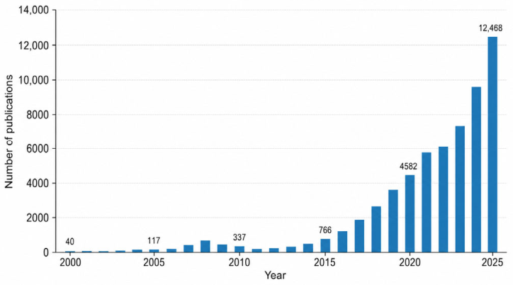
Scientific publications related to drone technologies have experienced remarkable growth over the past two decades. As illustrated in
Figure 1, research activity remained relatively limited during the early 2000s, with only a small number of publications produced annually. Between 2000 and 2010, the growth rate was relatively slow, reflecting the early development stage of drone technologies and their limited applications.
Since 2015, the number of publications has increased rapidly, demonstrating strong academic and industrial interest in drones. The annual publication output exceeded 5000 publications by 2021 and continued to rise sharply, reaching more than 12,000 publications in 2025. This growth indicates that drones have evolved from a specialized technological topic into a major interdisciplinary research area with applications across logistics, emergency response, environmental monitoring, smart cities, infrastructure inspection, and low-altitude mobility systems.
2.2. Geographical Distribution
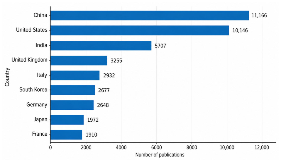
The geographical distribution of publications demonstrates widespread international engagement in drone research. As shown in
Figure 2, China is the leading contributor to the field, producing more than 11,000 publications. The United States ranks second, with over 10,000 publications, followed by India, with approximately 5700 publications. Other major contributors include the United Kingdom, Italy, Germany, South Korea, Japan, and France.
Leading countries have adopted different strategic pathways for drone development. While the publication counts presented above indicate the relative research activity of each country, they do not by themselves identify national application priorities. The following observations are therefore based on representative studies, policies, and initiatives reported in the literature and summarized in
Table 1. In China, prominent applications include smart agriculture, logistics and delivery systems, urban surveillance, and the development of the low-altitude economy. In the United States, representative initiatives concern autonomous systems, emergency response, airspace integration, and precision agriculture. In India, relevant applications include agricultural monitoring, rural mapping, disaster management, and smart-city development.
An important observation is the strong representation of Asian countries among the leading contributors. Besides China and India, South Korea and Japan have also become major centers of drone innovation, with representative initiatives related to smart-city ecosystems, UAM, and AI-enabled navigation in South Korea, and disaster response, infrastructure inspection, and autonomous robotics in Japan. European countries also play an important role in drone research and deployment, with representative applications including healthcare logistics and infrastructure inspection in the United Kingdom, industrial and energy-infrastructure inspection in Germany, cultural-heritage preservation and post-disaster assessment in Italy, and environmental monitoring and defense-related applications in France. These examples illustrate different national development pathways but should not be interpreted as exhaustive national specializations.
China, the European Union, and the United States also differ in their regulatory and institutional pathways for drone development. China has increasingly linked drone deployment with the broader development of the low-altitude economy, supported by coordinated policy and industrial initiatives [
3]. The European Union follows a harmonized and risk-based regulatory approach, with U-space providing an important framework for the integration of increasingly complex drone operations [
4,
5]. In the United States, development is mainly based on the progressive integration of unmanned aircraft into the existing national airspace system, with particular emphasis on operational safety and authorization procedures [
6]. Despite these differences, all three regions still face common challenges related to airspace integration, infrastructure readiness, safety, and regulatory maturity. Representative application areas and initiatives of these leading countries are shown in
Table 1.
Table 1.
Representative applications and projects/initiatives of leading countries.
Table 1.
Representative applications and projects/initiatives of leading countries.
| Country | Representative Applications | Representative Projects/Initiatives |
|---|
| China | Smart agriculture, logistics, low-altitude
economy, urban surveillance | Shenzhen Low-Altitude Economy Pilot Zone [7]; JD Logistics Drone Delivery Network [8];
Agricultural Drone Deployment [9] |
| United States | Autonomous navigation, emergency response, airspace integration, precision agriculture | Federal Aviation Administration (FAA) Unmanned aircraft system (UAS) Integration Pilot Program [10]; FAA UAS Test Site Program [11] |
| India | Agricultural monitoring, disaster
management, smart-city applications | Drone Shakti Initiative [12]; Smart Cities
Mission Drone Projects [13] |
United
Kingdom | Healthcare logistics, infrastructure
inspection, autonomous drone operations | National Health Service Drone
Medical Delivery Trials [14] |
| Germany | Industrial inspection, energy
infrastructure monitoring | Wind Turbine Drone Inspection Projects [15] |
| Italy | Cultural heritage preservation, disaster
response, post-disaster assessment | Post-Earthquake UAV Assessment Program [16] |
South
Korea | Smart cities, UAM,
AI-enabled navigation | Smart City National Pilot Program [17] |
| Japan | Disaster management, infrastructure
inspection, autonomous robotics | Noto Peninsula Earthquake
Drone Response [18] |
| France | Environmental monitoring,
defense applications | Airbus Drone Initiatives [19] |
In terms of development maturity, the three regions also demonstrate different strengths. China has achieved relatively rapid commercialization in logistics, agriculture, and low-altitude economic applications, while the European Union has established a comparatively mature regulatory architecture but remains more cautious in large-scale operational deployment.
The United States has accumulated extensive experience in testing and operational integration, although scalable beyond visual line of sight (BVLOS) and highly autonomous operations still require further regulatory development. The main barriers also differ across regions, including low-altitude airspace coordination and infrastructure standardization in China, consistent implementation and interoperability of U-space services across European Union Member States, and regulatory approval and scalable airspace integration in the United States.
Looking ahead, future development is expected to focus on broader low-altitude economic integration in China, increasingly interoperable U-space services in the European Union, and expanded BVLOS operations, automation, and advanced air mobility (AAM) integration in the United States.
A comparative summary of the policy context, development characteristics, application areas, current maturity, main barriers, and future trends in China, the European Union, and the United States is provided in
Table 2.
2.3. Methodological Approach and Research Framework
The evidence from annual publication trends and geographical distribution demonstrates the rapid expansion and growing significance of drone research worldwide. Methodologically, this study is conceived as a conceptual framework-development study supported by descriptive bibliometric analysis, literature-based conceptual synthesis, and a quantitative comparison of the literature supporting the proposed framework.
The descriptive bibliometric analysis presented in
Section 2.1 and
Section 2.2 was based on records retrieved from the Scopus database using the search query TITLE-ABS-KEY (drone). The analysis considered publications from 2000 to 2025 and examined annual publication trends and the geographical distribution of drone-related research. Records were screened for relevance to UAVs and UASs. Records referring to biological uses of the term “drone”, including male bees, as well as other non-aerial meanings of the term, were excluded during the screening process.
The Scopus dataset was extracted in May 2026. No restrictions were applied by document type; therefore, all document types indexed in Scopus and returned by the search query were considered in the descriptive bibliometric analysis. Annual publication counts were obtained by grouping the retrieved records by publication year, while geographical counts were based on the country/territory information provided by Scopus. In the case of publications involving affiliations from multiple countries, each represented country contributed to the corresponding geographical count. The resulting data were processed to obtain the annual and country-level distributions reported in
Figure 1 and
Figure 2.
The literature supporting the development of the four-dimensional framework was identified through searches in Scopus, IEEE Xplore, and Google Scholar, supplemented by relevant references identified from the reviewed literature. Search terms combined general expressions such as “drone”, “unmanned aerial vehicle”, and “unmanned aircraft system” with application-specific terms related to last-mile delivery, medical logistics, emergency communication, traffic and environmental monitoring, infrastructure inspection, UAM, eVTOL aircraft, unmanned traffic management (UTM), U-space, and vertiports. Peer-reviewed journal articles and conference papers were prioritized, while selected institutional documents, theses, and preprints were retained when they provided relevant information not sufficiently covered by the peer-reviewed literature. Publications were screened on the basis of title, abstract, and, where necessary, full-text relevance. Studies were included when they directly addressed drone technologies, applications, planning, operation, or integration issues relevant to the mobility functions considered in this study. Publications were excluded when their main focus was unrelated to aerial drone systems or when they did not provide information relevant to the proposed framework.
The selected literature was then synthesized according to the principal resource or function enabled by drones across space: physical goods, information, sensing capability, or people. This process resulted in four analytical dimensions: goods mobility, information mobility, sensing mobility, and human mobility. These four dimensions were selected because they represent four distinct primary functions repeatedly identified across the analyzed applications: the transport of physical goods, the transmission or dissemination of information, the spatial deployment of sensing capabilities, and the transport of people. They are not intended to be strictly mutually exclusive, since individual drone applications may involve more than one function. In such cases, classification is based on the primary operational purpose of the application.
In particular, information mobility refers primarily to the transmission, relay, or dissemination of information between actors or infrastructures, whereas sensing mobility refers primarily to the acquisition and observation of data through onboard sensors. Therefore, a sensing mission may subsequently transmit the collected data, but it is classified as sensing mobility when data acquisition constitutes its principal function.
The Scopus-based bibliometric analysis therefore provides the context for understanding the development and geographical distribution of drone research, while the literature identified through Scopus, IEEE Xplore, Google Scholar, and complementary sources provides the evidence base for the detailed analysis of the four mobility dimensions. The references directly supporting
Section 3.1,
Section 3.2,
Section 3.3 and
Section 3.4 were subsequently analyzed according to their principal mobility dimension, and their frequencies and percentages were calculated in
Section 3.5 to provide a quantitative comparison of the literature supporting the proposed framework.
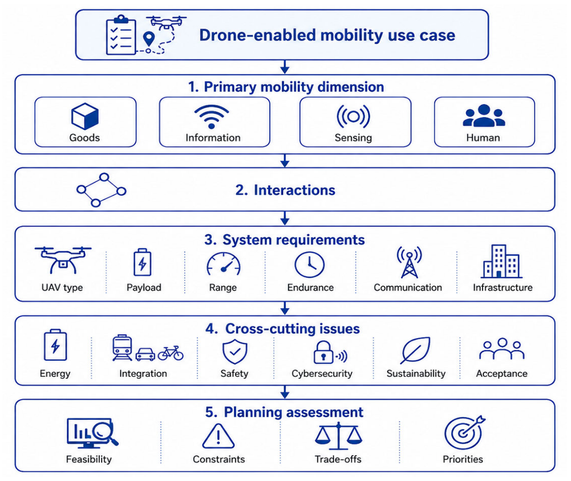
To translate the four-dimensional framework into a structured planning approach,
Figure 3 illustrates its application workflow. Starting from a specific drone-enabled mobility use case, the process identifies the primary mobility dimension and its interactions with the other dimensions, followed by the definition of the main system requirements. The relevant cross-cutting issues are then assessed to support a planning evaluation in terms of feasibility, constraints, trade-offs, and implementation priorities. This workflow complements the relational structure of the framework presented in
Section 3 and the framework-specific planning responses discussed in
Section 4.4.
3. A Four-Dimensional Framework for Drone-Enabled Mobility
The rapid expansion of drone applications demonstrates that UAVs are no longer limited to isolated technological functions but increasingly contribute to multiple forms of mobility. Logistics, emergency communication, sensing, and aerial mobility applications are often developed and analyzed as separate operational domains. However, these domains can be interpreted as complementary components of a broader drone-enabled mobility ecosystem. To provide a more integrated interpretation of this role, this article proposes a four-dimensional framework consisting of goods mobility, information mobility, sensing mobility, and human mobility. Together, these dimensions provide a structured basis for analyzing how drones can support last-mile delivery, emergency medical response, smart-city services, and future low-altitude mobility systems.
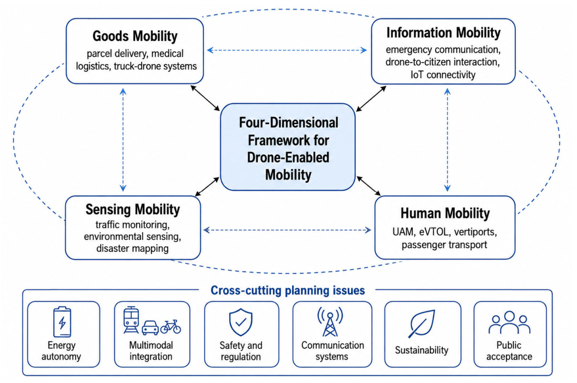
The relationships among the four dimensions are summarized in
Figure 4. The framework emphasizes that goods, information, sensing, and human mobility are not independent domains, but interconnected components of a broader drone-enabled mobility ecosystem. Their interactions are supported by common cross-cutting planning issues, including energy autonomy, multimodal integration, safety and regulation, communication systems, sustainability, and public acceptance.
The proposed framework is intended to accommodate different UAV configurations, although their suitability varies according to the specific mobility function and operational requirements. Fixed-wing UAVs generally offer greater endurance and range and are therefore particularly suitable for long-distance sensing, monitoring, and communication missions, whereas rotary-wing and multirotor UAVs provide hovering capability and vertical take-off and landing, making them more appropriate for urban logistics, infrastructure inspection, and localized operations. Hybrid configurations combine characteristics of both architectures, while eVTOL aircraft represent the main technological reference for the human mobility dimension. Therefore, the four-dimensional framework is not restricted to a specific UAV type, but its practical implementation should account for configuration-specific capabilities and limitations.
3.1. Goods Mobility
Goods mobility represents the most mature and operationally developed dimension of drone-enabled mobility. Among emerging drone applications, the transport of physical goods has received substantial industrial attention and has generated numerous pilot projects, commercial implementations, and scientific studies. The rapid growth of e-commerce and increasing urbanization have accelerated the search for innovative logistics solutions capable of improving delivery efficiency while reducing environmental impacts and operational costs [
20,
21]. Traditionally, logistics systems rely on road transportation networks composed of warehouses, distribution centers, freight vehicles, and delivery personnel. However, the last-mile segment remains one of the most expensive and inefficient stages of the supply chain, often accounting for a disproportionate share of total logistics costs [
20]. Urban congestion, limited parking availability, labor shortages, and increasing delivery frequencies further aggravate these challenges. In this context, drones have emerged as complementary technologies capable of extending the operational capabilities of conventional logistics systems rather than replacing them entirely.
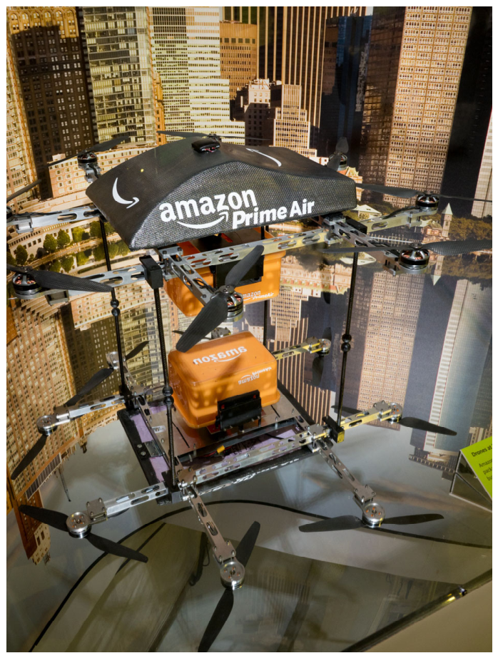
The first major application of drone-enabled goods mobility concerns parcel delivery. Companies such as Amazon, DHL, Alibaba, JD Logistics, and Walmart have conducted extensive experimentation with autonomous delivery services in both urban and rural environments [
22].
Figure 5 shows a real-world example of a commercial drone delivery platform, namely an Amazon Prime Air delivery drone, clearly illustrating the aircraft configuration and its payload arrangement.
Beyond commercial parcel delivery, one of the most socially relevant applications of goods mobility concerns healthcare and emergency logistics. Medical deliveries often require rapid transportation under strict time constraints, making them particularly suitable for drone operations. Several projects have demonstrated the feasibility of using drones to transport blood products, vaccines, medicines, laboratory samples, and emergency medical equipment [
23,
24].
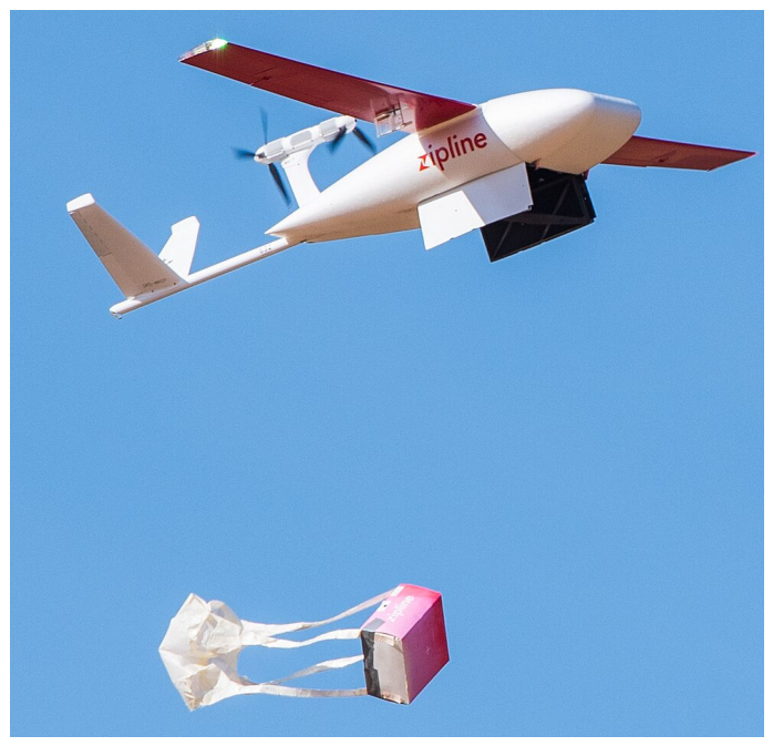
The Zipline network operating in Rwanda and Ghana represents one of the first large-scale examples of drone-based healthcare logistics, providing regular deliveries to remote hospitals and clinics [
25]. Similar initiatives have been implemented in Europe and North America, especially during the coronavirus disease 2019 (COVID-19) pandemic, when drones were used to support healthcare supply chains and reduce physical contact during transportation operations [
26].
Figure 6 illustrates a representative example of healthcare and emergency medical logistics by drones, highlighting their potential role in transporting time-sensitive medical supplies.
The growing role of drones in healthcare logistics highlights an important characteristic of goods mobility: the value and urgency of transported goods are often more important than their physical weight. Although many drone platforms remain limited in payload capacity, they can generate significant societal benefits when transporting high-value and time-sensitive products. Consequently, future drone logistics systems are expected to expand not only within commercial delivery markets, but also in emergency management, humanitarian operations, disaster response, and public health services.
From a mobility perspective, goods transportation by drones should not be viewed as an isolated technological innovation, but as part of a broader multimodal logistics ecosystem. Current evidence suggests that fully autonomous depot-to-customer delivery systems remain operationally limited due to battery constraints, payload restrictions, weather sensitivity, and regulatory requirements [
27]. For this reason, recent research increasingly focuses on integrated logistics architectures that combine drones with existing transportation infrastructures.
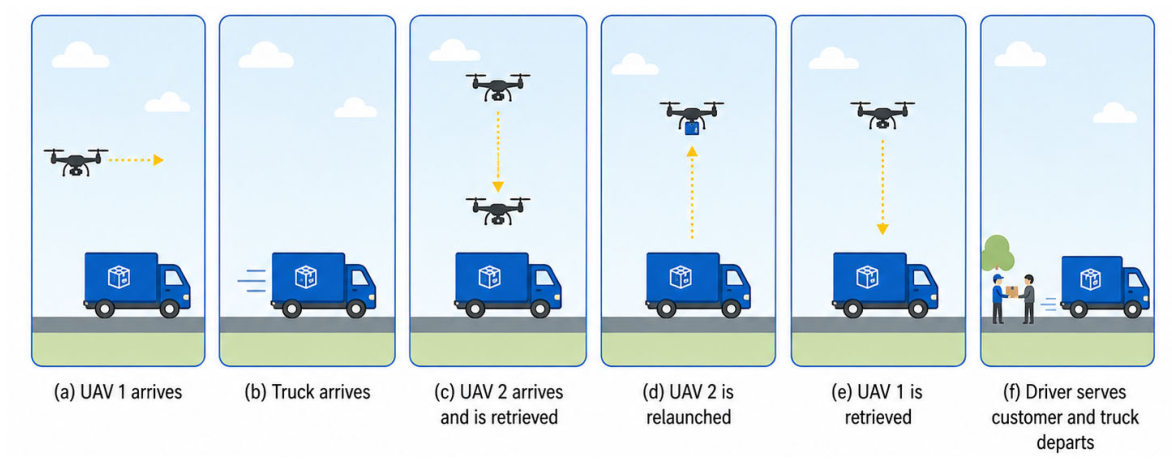
One of the most significant developments concerns hybrid truck–drone systems. In these configurations, drones operate as aerial extensions of conventional delivery vehicles, while trucks serve as mobile logistics hubs carrying parcels, batteries, and multiple drones that can be deployed during delivery operations.
This approach combines the flexibility and speed of aerial transport with the carrying capacity and operational reliability of road vehicles [
28]. Several optimization studies have shown that integrated truck–drone operations can improve service performance, particularly in areas characterized by dispersed demand or difficult accessibility [
29,
30].
Figure 7 illustrates a representative operational sequence of an integrated truck–drone delivery system, showing how drone arrivals, retrievals, relaunches, and customer service can be coordinated at a truck stop.
Similarly, researchers have proposed the use of micro-hubs, urban consolidation centers, and decentralized depot networks to support drone deployment [
31]. Instead of relying exclusively on large centralized warehouses, future logistics systems may operate through networks of strategically located facilities where goods are temporarily stored, sorted, and transferred between transportation modes. In such systems, drones become one component of a larger distribution network that integrates road vehicles, public transportation systems, automated lockers, and urban logistics hubs. This evolution reflects a broader shift from vehicle-centered logistics toward network-centered logistics. The key challenge is no longer the optimization of individual drone flights, but the coordination of multimodal delivery ecosystems. Consequently, recent studies have adopted network design approaches inspired by hub-and-spoke structures commonly used in freight transportation and public transport planning [
32].
Optimization remains a central research topic within goods mobility. Existing studies have investigated several forms of the vehicle routing problem with drones (VRPD), addressing route planning, fleet sizing, scheduling, battery management, and customer assignment [
33,
34,
35]. More recently, multi-objective optimization approaches have emerged to simultaneously consider economic efficiency, service reliability, sustainability, and operational resilience [
36,
37,
38,
39,
40]. These approaches better reflect the trade-offs faced by logistics operators, where minimizing costs may conflict with delivery reliability, customer satisfaction, or environmental objectives.
The sustainability implications of drone logistics must also be assessed cautiously. Although electrically powered drones can reduce direct operational emissions, their overall environmental performance depends on multiple factors, including the electricity generation mix, battery production and replacement, payload capacity, flight distance, infrastructure requirements, fleet utilization, and the extent to which drone operations actually substitute conventional vehicle trips [
41]. Therefore, drones should not be assumed to be inherently more sustainable than ground-based alternatives. Depending on demand density, payload, trip characteristics, and existing infrastructure, electric vans, cargo bicycles, or public transport-based logistics may provide comparable or lower environmental impacts. Future assessments should therefore adopt life-cycle and system-level perspectives capable of comparing alternative transport configurations under consistent operational conditions.
Overall, goods mobility is expected to evolve from simple point-to-point drone deliveries toward integrated logistics ecosystems in which drones function as dynamic and intelligent transportation assets. Advances in autonomous navigation, AI, battery technologies, communication systems, and traffic management platforms will enable increasingly sophisticated operational concepts. Rather than replacing traditional freight transportation, drones are likely to complement existing modes by providing rapid, flexible, and resilient services within multimodal logistics networks. The key application scenarios, advantages, and current challenges of goods mobility are summarized in
Table 3.
3.2. Information Mobility
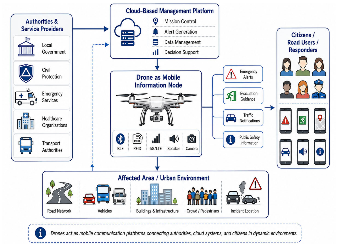
Information mobility refers to the capability of drones to support the transmission, relay, dissemination, and exchange of information across spatial environments. In this dimension, the primary role of the drone is to enable communication and information transfer between citizens, infrastructure, sensor networks, emergency services, and public authorities, rather than to perform the sensing activity itself. While early drone applications mainly focused on surveillance and the transport of physical goods, recent advances in wireless communications, Internet of Things (IoT) technologies, and smart-city infrastructures have significantly expanded their functional role. In this context, information itself becomes a mobile resource, and drones can operate as mobile communication platforms connecting citizens, infrastructure, sensor networks, emergency services, and public authorities [
42].
Modern urban and territorial systems rely on information flows to support transportation management, emergency response, public safety, environmental monitoring, and urban operations. However, traditional communication systems usually depend on fixed infrastructures, such as cellular networks, broadcasting systems, and internet platforms. During disasters, major incidents, large public events, or operations in remote areas, these infrastructures may be damaged, overloaded, or unavailable. In such situations, drones can provide a flexible and rapidly deployable communication layer capable of delivering information services where they are most needed.
Their mobility enables information to be transported, relayed, and disseminated beyond the limitations of fixed communication infrastructures [
43].
Figure 8 illustrates the conceptual drone-to-citizen communication architecture considered in this article, showing how drones can operate as mobile information nodes linking authorities, cloud-based management platforms, and citizens to support real-time communication and emergency information delivery.
One of the most representative applications of information mobility is emergency communication. During natural disasters, industrial accidents, traffic incidents, and public safety emergencies, access to timely and reliable information is critical for effective response and decision-making. Drones can rapidly reach affected areas and disseminate geographically targeted warnings, evacuation instructions, traffic notifications, and operational updates. Drone-based communication services can provide location-specific and context-aware information, supporting both emergency guidance and direct interaction with people located in affected areas [
43]. In this role, drones act as intermediaries between authorities and citizens, enabling the direct dissemination of warnings, instructions, and public information [
44].
A representative example is provided by the European Horizon 2020 “sAfe Urban aiR mObility for euRopeAn citizens” (AURORA) project [
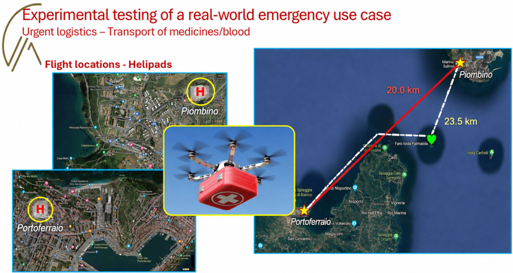
45]. The project investigated the integration of drones into urban mobility and emergency contexts, with particular attention to urgent logistics, first aid, smart cities, and stakeholder engagement. Through a co-creation process involving aviation authorities, local governments, healthcare organizations, civil protection agencies, emergency services, and infrastructure operators, several information-related use cases were identified, including direct drone-to-citizen communication, emergency alerts, traffic incident notifications, and public safety information dissemination.
To support these services, the project developed and tested a communication architecture integrating drones, Bluetooth Low-Energy (BLE) beacons, radio-frequency identification (RFID) technologies, cloud-based management systems, and smartphone applications.
Figure 9 shows a real-world emergency use case from the AURORA project, illustrating how drones can support urgent medical logistics and emergency operations through rapid aerial transport and coordinated information exchange.
Beyond public information dissemination, drones are increasingly being employed as airborne communication infrastructures. In regions where terrestrial communication networks are damaged or unavailable, drones can be equipped with wireless communication devices and deployed as temporary flying base stations or communication relays. Deruyck et al. [
46] investigated UAV-assisted emergency communication networks for large-scale disaster scenarios, showing that drones equipped with Long-Term Evolution (LTE) micro base stations can rapidly restore communication services in affected areas and improve connectivity for both emergency responders and civilians. In these applications, drones do not only transmit information; they actively extend communication coverage and provide communication services where fixed infrastructures have failed.
Another important application area of information mobility is emergency response support. Li et al. [
47] investigated the integration of autonomous drones into firefighting activities through field trials involving Swiss fire departments. In their proposed system, drones were used to conduct aerial reconnaissance, search for victims, assess environmental conditions, and communicate with firefighters, victims, and bystanders through visual and audio interactions. Information collected by the drones was transmitted to commanders through real-time video streams, maps, and decision-support interfaces, enabling faster situational assessment and operational coordination. These findings highlight the role of drones as mobile information platforms that improve situational awareness during emergency operations.
Traffic information services represent another emerging application. Drones can support transportation authorities and road users by providing real-time traffic updates, accident notifications, and congestion warnings [
48]. Unlike fixed intelligent transportation systems (ITS) infrastructures, drones can be dynamically deployed to locations where disruptions occur, enabling more flexible and responsive information services. This capability becomes particularly valuable during major events, road network failures, and temporary traffic disruptions.
Information mobility also plays an important role in crowd management and public event operations. Large gatherings such as concerts, sporting events, festivals, and religious celebrations often involve rapidly changing crowd dynamics and high communication needs [
49]. In these contexts, drones can support both monitoring and information dissemination, helping authorities manage crowd flows, communicate safety instructions, and respond to emerging risks.
Environmental risk communication constitutes another relevant application area. Drones can support communication activities related to wildfires, floods, air pollution events, hazardous material releases, and other environmental threats. While sensing systems may detect these risks, drones can help ensure that risk-related information is rapidly communicated to decision-makers, emergency responders, and affected populations. In this role, drones serve as communication intermediaries that transform environmental observations into actionable warnings and operational guidance [
50].
A further example can be found in UAV-assisted IoT communication systems. In many applications, including agriculture, environmental monitoring, and remote infrastructure management, sensor networks are deployed in areas where permanent communication infrastructures are unavailable or difficult to establish.
To address this challenge, drones can function as mobile gateways that collect data from distributed sensors and deliver them to monitoring stations, communication gateways, or cloud-based platforms. For example, Islam et al. [
51] demonstrated the integration of UAVs and IoT technologies in smart farming, where drones equipped with communication gateways gather information from ground sensors across large agricultural areas and transmit the collected data to remote infrastructures for further processing and analysis. By physically moving between disconnected sensing nodes and communication networks, drones facilitate information transfer across space and enhance connectivity in remote environments. Overall, these examples show that drones are evolving into mobile information platforms capable of supporting efficient information exchange across diverse environments. Nevertheless, their widespread adoption requires addressing challenges related to cybersecurity, privacy protection, communication reliability, spectrum management, interoperability, and public acceptance. As communication infrastructures continue to evolve, secure, reliable, and resilient drone-enabled information services will become increasingly important for emergency response, smart-city operations, and remote-area connectivity. The key application scenarios, advantages, and current challenges of information mobility are summarized in
Table 4.
3.3. Sensing Mobility
Sensing mobility refers to the capability of drones to dynamically deploy sensing functions across space through onboard sensors, imaging systems, and communication technologies. Unlike goods mobility, which focuses on transporting physical products, and information mobility, which concerns the dissemination and exchange of information, sensing mobility enables the movement of sensing capabilities themselves.
Through the integration of red-green-blue (RGB) cameras, thermal imagers, light detection and ranging (LiDAR) systems, multispectral and hyperspectral sensors, gas detectors, and wireless communication modules, drones can operate as mobile observation platforms capable of collecting, processing, and transmitting real-time data across large geographic areas [
52]. Recent advances in sensor miniaturization, AI, edge computing, and wireless communications have expanded the role of drones from simple aerial observation tools to intelligent sensing infrastructures supporting decision-making in transportation, environmental management, emergency response, and infrastructure maintenance.
One of the most mature applications of sensing mobility is traffic monitoring within ITS. Traditional traffic monitoring infrastructures rely heavily on fixed cameras, loop detectors, and roadside sensors, which often suffer from limited spatial coverage, high installation costs, and reduced flexibility. Drones provide a flexible and rapidly deployable alternative capable of acquiring aerial traffic data over large areas while maintaining a comprehensive bird’s-eye perspective. Recent studies have demonstrated the effectiveness of UAV-based systems for vehicle detection, traffic counting, speed estimation, trajectory extraction, congestion analysis, and accident monitoring.
In particular, deep-learning-based object detection algorithms have become a dominant approach for extracting traffic information from aerial imagery. Byun et al. [
53] employed a You Only Look Once (YOLO)-based framework for vehicle detection and speed estimation using UAV videos, demonstrating the feasibility of real-time traffic monitoring using drones. Similarly, Butilă and Boboc [
54] showed that UAV-assisted traffic monitoring can support vehicle classification, congestion detection, and traffic-flow analysis. More recently, Afrin et al. [
55] highlighted the growing integration of UAV sensing with ITS, where drones act as dynamic sensing nodes capable of supporting adaptive traffic management and incident response. These studies show that drones are evolving from passive observation platforms to intelligent traffic sensing agents capable of supporting real-time transportation decision-making.
Environmental monitoring represents another important dimension of sensing mobility. Conventional environmental monitoring systems are typically based on stationary observation stations that provide accurate but spatially limited measurements. Drones can overcome this limitation by enabling data collection across multiple locations and altitudes, generating high-resolution environmental datasets with improved spatial coverage [
56]. Applications include air-quality monitoring, greenhouse gas detection, urban heat-island assessment, water-quality analysis, vegetation monitoring, biodiversity assessment, and ecosystem management [
57,
58]. To support these applications, drones are frequently equipped with particulate matter sensors, carbon dioxide sensors, methane detectors, thermal cameras, and multispectral imaging systems. Sharma et al. and Bakirci [
59,
60] highlighted that UAVs can provide higher spatial resolution and flexible three-dimensional monitoring in urban environments. Furthermore, recent research increasingly combines UAV sensing with machine-learning algorithms to identify pollution patterns, classify environmental conditions, and predict ecological risks. The integration of drones with IoT infrastructures and cloud-based analytical platforms further enhances their ability to support sustainable urban and environmental management.
Disaster assessment and emergency mapping constitute one of the most socially valuable applications of sensing mobility. During earthquakes, floods, landslides, hurricanes, and wildfires, rapid access to reliable situational information is essential for effective emergency response. Conventional ground surveys are often constrained by damaged infrastructure, inaccessible terrain, and safety risks.
Drones provide a rapid and flexible alternative capable of acquiring high-resolution imagery immediately after a disaster [
61]. Modern disaster-management applications employ drones for damage assessment, victim search and rescue, flood mapping, wildfire monitoring, and post-disaster reconnaissance [
62,
63]. Technological advances such as photogrammetry, simultaneous localization and mapping (SLAM), and three-dimensional reconstruction have significantly enhanced the ability of drones to generate accurate representations of affected areas. At the same time, computer vision and deep learning algorithms are increasingly used to automate damage detection and classify affected structures from aerial imagery. Yucesoy et al. [
64] highlighted the important role of drones in enhancing situational awareness, search and rescue, and emergency coordination. Their rapid deployment and real-time data acquisition capabilities can help reduce response times and operational risks during emergency operations.
Infrastructure inspection is also one of the most mature applications of sensing mobility. Transportation networks, energy infrastructures, industrial facilities, and public utilities require regular inspections to ensure safety and operational reliability. Traditional inspection methods often involve substantial labor costs, service interruptions, and safety risks for personnel. Drones provide a safer and more efficient alternative. Typical inspection targets include bridges, highways, railways, tunnels, dams, pipelines, power transmission lines, and wind turbines. Equipped with high-resolution cameras, thermal sensors, and LiDAR systems, drones can identify structural defects, thermal anomalies, corrosion, cracks, and deformation [
65]. Recent developments in AI have further enhanced inspection capabilities.
Ayele et al. [
66] proposed an integrated UAV-assisted bridge inspection framework in which deep-learning-based image analysis automatically detects and quantifies structural cracks from aerial imagery. This combination of drone sensing, computer vision, and three-dimensional reconstruction not only improves inspection efficiency, but also provides condition data for predictive maintenance, contributing to enhanced infrastructure resilience and reduced lifecycle maintenance costs.
Despite the diversity of these applications, several challenges continue to limit large-scale deployment. Battery constraints restrict flight duration and operational coverage, while adverse weather conditions may affect sensing performance and mission reliability. Large-scale UAV operations also generate substantial volumes of data that require efficient transmission, storage, processing, and interpretation.
Future research is expected to increasingly integrate UAV sensing with digital-twin infrastructures and multi-source data fusion. Recent studies have demonstrated that UAV photogrammetry can support the creation of three-dimensional digital twins for infrastructure inspection and automated damage detection, while the fusion of UAV-derived data with terrestrial laser-scanning data can improve digital model completeness and damage assessment [
67,
68]. These approaches provide a promising basis for more systematic and data-driven infrastructure monitoring.
Ultimately, sensing mobility is expected to evolve from individual drone missions toward intelligent and interconnected sensing networks that support the broader transition toward resilient, sustainable, and data-driven mobility systems. The representative applications, typical scenarios, major advantages, and current challenges of sensing mobility are summarized in
Table 5.
3.4. Human Mobility
Human mobility represents the least mature but potentially transformative dimension of drone-enabled mobility. Unlike conventional drone applications that transport goods, exchange information, or perform sensing tasks, human mobility introduces stricter requirements in terms of safety, reliability, certification, passenger comfort, and public acceptance [
69]. Battery thermal behavior and degradation under high-power eVTOL mission profiles also represent important safety and reliability considerations [
70].
In this context, the related terminology should be distinguished carefully. Electric vertical take-off and landing (eVTOL) refers primarily to an aircraft technology and configuration, whereas urban air mobility (UAM) describes the use of aerial mobility services within urban and metropolitan environments. Advanced air mobility (AAM) represents a broader concept that may also encompass regional and other emerging aerial mobility services beyond strictly urban operations. Autonomous passenger drones, in turn, refer specifically to passenger-carrying aerial vehicles designed to operate with high levels of automation or without an onboard pilot. These concepts are therefore related but not equivalent and are considered within the human mobility dimension according to their respective technological and operational roles [
7,
71].
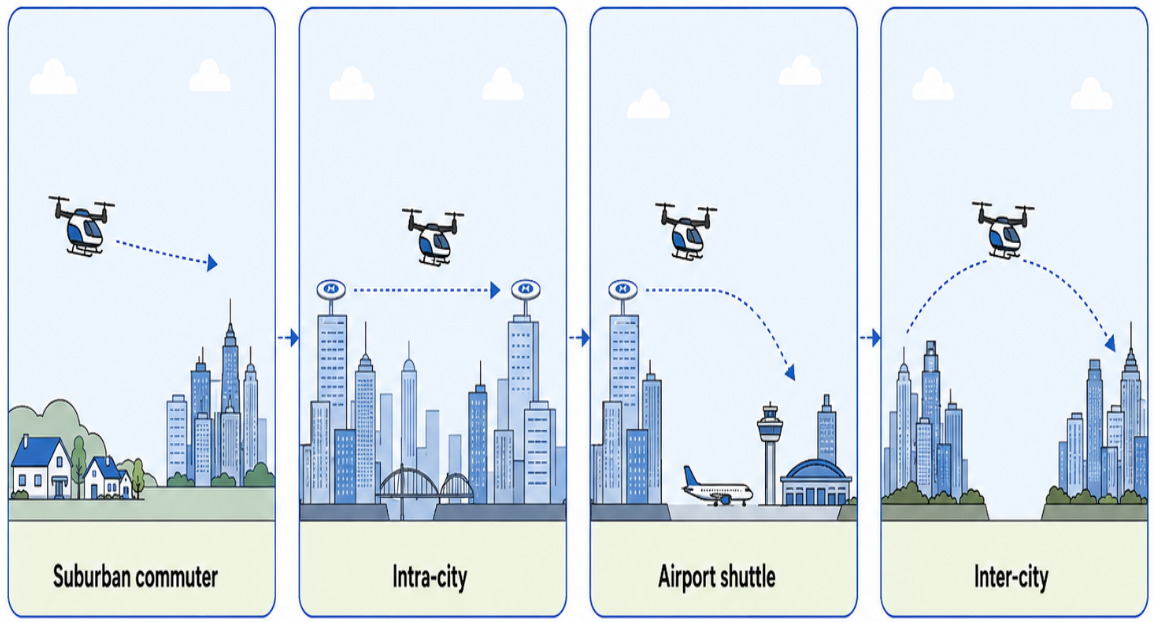
The objective of this mobility dimension is to create an additional aerial layer capable of complementing existing ground transportation systems, reducing travel times, improving accessibility, and supporting regional and urban connectivity. Potential use cases include airport shuttle services, intra-city connections, suburban commuting, inter-city links, and emergency passenger transport.
Figure 10 schematically illustrates representative UAM use cases, including suburban commuting, intra-city mobility, airport shuttle services, and inter-city connections, highlighting the different spatial and service configurations of passenger aerial mobility [
72].
The technological foundation of human mobility is the development of eVTOL aircraft. Unlike conventional helicopters, most eVTOL platforms rely on distributed electric propulsion (DEP), where multiple electrically powered rotors are distributed across the airframe. This architecture can improve fault tolerance, controllability, noise performance, and propulsion efficiency. Current eVTOL designs include multicopters, lift-and-cruise aircraft, vectored-thrust aircraft, tilt-rotor concepts, and rotorcraft, each characterized by different trade-offs in range, payload, efficiency, noise, and operational complexity [
72]. However, no single configuration has yet emerged as the dominant solution, reflecting the still-evolving nature of passenger drone technologies.
Energy performance remains one of the main constraints for human mobility. Current eVTOL platforms primarily rely on high-performance lithium-ion batteries, while emerging solutions include solid-state batteries, hybrid-electric propulsion systems, hydrogen fuel cells, and battery-swapping strategies. Despite ongoing progress, battery energy density continues to limit flight endurance, operational range, payload capacity, and turnaround times [
73,
74]. As a result, the economic viability of large-scale UAM services will depend not only on aircraft design, but also on advances in energy storage, charging infrastructure, and fleet management.
Autonomous flight technologies constitute another critical enabler of human mobility. Early UAM operations are likely to rely on human pilots, but the long-term scalability of aerial passenger transport depends heavily on automation. Research in this area focuses on AI-based flight control, computer vision, sensor fusion, obstacle detection, collision avoidance, and autonomous decision-making. Particular attention has been devoted to detect-and-avoid (DAA) and collision-avoidance systems, which are essential for maintaining safe separation from cooperative and non-cooperative airspace users. Recent studies have evaluated collision-avoidance strategies specifically for UAM aircraft and have demonstrated the feasibility of multi-sensor Sense-and-Avoid architectures integrating optical and radar sensing with real-time conflict detection and avoidance functions [
75,
76].
Certification and regulatory readiness represent critical barriers to the implementation of human mobility. Compared with conventional UAV operations, passenger-carrying eVTOL aircraft must satisfy substantially more stringent requirements related to airworthiness, system reliability, redundancy, emergency procedures, and operational safety.
The introduction of novel aircraft configurations, distributed propulsion systems, and increasingly automated flight functions further increases the complexity of certification, since both vehicle-level and operational requirements must be addressed. This challenge becomes particularly relevant for autonomous or highly automated passenger services, where the reliability of flight-control, communication, sensing, and decision-making systems must also be demonstrated. Consequently, the transition from experimental demonstrations to large-scale human mobility services will depend not only on technological maturity, but also on the progressive development of appropriate certification procedures and regulatory frameworks.
The implementation of human mobility also requires new approaches to airspace management. Traditional air traffic management (ATM) systems were designed for conventional aviation and are not suitable for managing high-density, low-altitude operations involving large numbers of autonomous or semi-autonomous aerial vehicles. For this reason, UTM [
77] and U-space [
78] concepts have emerged as key frameworks for low-altitude airspace coordination. These systems aim to provide dynamic route allocation, trajectory management, geofencing, conflict detection, communication services, and automated deconfliction. Scalable passenger drone operations will therefore depend on digital traffic management architectures capable of coordinating multiple flights while maintaining acceptable levels of safety and efficiency [
79].
Ground infrastructure is another fundamental component of human mobility systems. UAM operations require networks of vertiports distributed across urban and regional environments. Vertiports serve as take-off and landing facilities while also supporting passenger handling, battery charging, energy management, maintenance, safety procedures, and integration with other transportation modes.
Recent research on vertiport planning has focused on facility location, capacity analysis, passenger flow management, charging systems, and multimodal connectivity [
80]. Under high-demand conditions, vertiport capacity and charging efficiency may become critical bottlenecks, making infrastructure planning a central determinant of future system performance [
81].
Reliable communication systems are equally essential. Human mobility operations require continuous information exchange among aircraft, vertiports, traffic management platforms, communication networks, and ground infrastructures.
Emerging research therefore focuses on fifth-generation (5G) and sixth-generation (6G) communication networks, edge computing, cloud services, vehicle-to-everything (V2X) communication, network slicing, and cyber–physical architectures [
82]. These technologies are expected to support low-latency communication, real-time monitoring, command-and-control functions, and large-scale fleet coordination. Despite significant technological progress, human mobility remains the most uncertain dimension of drone-enabled mobility.
Current limitations include battery performance, certification requirements, autonomous flight reliability, communication robustness, infrastructure costs, airspace integration, and public acceptance. Social concerns related to safety perception, noise, privacy, affordability, and environmental sustainability may also influence future deployment [
83,
84]. Consequently, the development of human mobility will require the coordinated evolution of aircraft technologies, digital infrastructures, regulatory frameworks, and societal acceptance mechanisms [
85].
Table 6 summarizes the main application scenarios, advantages, and current challenges associated with human mobility.
3.5. Quantitative and Cross-Dimensional Comparative Analysis
To provide a quantitative comparison of the proposed framework, the references directly supporting
Section 3.1,
Section 3.2,
Section 3.3 and
Section 3.4 were classified according to the four mobility dimensions. Each unique reference was assigned to the dimension in which it was primarily used.
A total of 67 unique references were included, and frequencies and percentages were calculated to compare the relative representation of the four dimensions. This quantitative comparison is complemented by the representative real-world applications discussed throughout
Section 3.1,
Section 3.2,
Section 3.3 and
Section 3.4, including operational medical delivery services, emergency communication projects, and field-tested drone applications in emergency response.
These examples are intended to illustrate the practical applicability of the proposed framework rather than to serve as standalone empirical case studies. Together with
Table 3,
Table 4,
Table 5 and
Table 6, these representative applications provide a structured mapping of use cases across the four mobility dimensions, linking each dimension to typical operational scenarios, advantages, and implementation challenges. As shown in
Table 7, the literature is unevenly distributed across the four mobility dimensions, with goods mobility representing the largest share, followed by human mobility and sensing mobility, while information mobility has the smallest share.
These results provide a quantitative description of the relative representation of the four dimensions within the literature supporting the proposed framework. Beyond this quantitative distribution, the four dimensions can also be interpreted through a common set of analytical criteria, including the primary resource or function, principal stakeholders, enabling technologies, infrastructure requirements, representative performance parameters, regulatory conditions, and current maturity.
Goods mobility primarily concerns the transport of physical payloads and is characterized by logistics operators, delivery and healthcare services, routing and autonomous-navigation technologies, depots and charging infrastructures, and performance parameters such as payload, range, delivery time, and cost.
Information mobility focuses on information transmission and dissemination among authorities, emergency services, citizens, and communication networks, with communication coverage, latency, reliability, and cybersecurity representing key considerations.
Sensing mobility is centered on the spatial deployment of sensing capabilities and data acquisition, relying on onboard sensors, AI-based processing, IoT, geographic information systems (GIS), and digital-twin infrastructures, with spatial coverage, resolution, data quality, and revisit frequency as relevant parameters.
Human mobility concerns passenger transport and therefore involves eVTOL aircraft, vertiports, traffic-management systems, aviation authorities, and substantially more stringent requirements for safety, certification, reliability, and operational performance. In terms of maturity, goods and several sensing applications currently show the highest level of operational development, information mobility includes both operational and experimental applications, while human mobility remains predominantly emerging.
Existing UAV classifications generally focus on individual technological or sectoral domains. Drone-logistics studies mainly address delivery architectures, routing, and logistics applications [
21,
27], smart-city and intelligent transportation studies emphasize communication, sensing, and monitoring functions [
42,
55], while UAM and AAM research primarily focuses on passenger transport, vertiports, airspace management, and integration with ground transportation [
71,
79]. The originality of the proposed framework lies in bringing these otherwise fragmented domains together through a common mobility-oriented classification principle based on the primary resource or function enabled by drones: goods, information, sensing capabilities, and people.
4. Cross-Cutting Planning Issues for Drone-Enabled Mobility
The four mobility dimensions discussed in
Section 3 highlight the diversity of drone-enabled applications, ranging from last-mile logistics and emergency communication to sensing services and future passenger mobility. However, their practical implementation depends on a set of cross-cutting planning issues that affect all application domains. These issues concern the technological, infrastructural, regulatory, environmental, and social conditions required for drones to operate safely, efficiently, and sustainably within multimodal mobility systems.
This section therefore discusses the main enabling factors and constraints that influence drone deployment across the four dimensions, with particular attention to energy autonomy, multimodal integration, safety and regulation, communication systems, sustainability, and public acceptance.
4.1. Energy Autonomy and Solar-Assisted Drones
Energy autonomy represents one of the main constraints affecting all dimensions of drone-enabled mobility. Regardless of whether drones are used for goods mobility, information mobility, sensing mobility, or human mobility, their operational performance is ultimately limited by onboard energy resources. Current drone platforms primarily rely on lithium-ion batteries because of their favorable balance between weight, cost, and energy density. However, battery technologies continue to impose significant restrictions on flight duration, operational range, payload capacity, and mission flexibility [
86].
The impact of energy constraints varies across the four mobility dimensions. In goods mobility, limited battery capacity restricts payload weight and delivery distance, reducing the operational and economic viability of drone-assisted logistics systems. In information mobility, communication relay missions may require prolonged hovering or repeated flights, resulting in high energy consumption. In sensing mobility, extensive data collection over large geographic areas creates trade-offs between monitoring quality, spatial coverage, and energy expenditure. Human mobility faces the most demanding requirements, since passenger transportation requires higher power levels, greater redundancy, and stricter safety margins [
69,
70,
74,
87].
In this context, safety margins refer to operational reserves and protective buffers intended to maintain safe operation under non-nominal conditions. These may include minimum energy reserves, redundant propulsion and control capabilities, separation margins from obstacles and other airspace users, conservative weather operating limits, and contingency or emergency landing provisions. Their specific numerical values cannot be defined universally, as they depend on aircraft configuration, mission characteristics, regulatory requirements, and local operating conditions.
To address these limitations, several technological pathways have been investigated. For instance, hydrogen-powered systems are particularly attractive for long-endurance missions because they can provide higher energy density than current battery technologies while producing minimal direct emissions. Nevertheless, challenges related to hydrogen storage, infrastructure availability, safety certification, and operational costs remain major barriers to large-scale implementation [
88,
89].
Among emerging solutions, solar-assisted drones have attracted increasing attention as a promising approach to extending operational endurance. By integrating photovoltaic cells into wings, fuselage surfaces, or auxiliary charging systems, drones can harvest solar energy during flight and partially compensate for onboard energy consumption. Fixed-wing solar-powered UAVs have demonstrated the ability to remain airborne for several hours or even days under favorable environmental conditions, making them particularly suitable for environmental monitoring, communication relay, disaster surveillance, and remote sensing missions [
90]. In addition, recent experimental research has investigated solar-assisted and duty-cycled recharging strategies for small drones, showing that intermittent energy harvesting can extend operational autonomy and support longer missions under favorable environmental conditions [
91].
The effectiveness of solar-assisted systems depends on several factors, including solar irradiance, weather conditions, aircraft configuration, geographical location, and photovoltaic efficiency. Fixed-wing platforms generally offer larger surface areas for solar-cell integration and therefore achieve higher energy-harvesting potential than multi-rotor systems.
Consequently, solar-assisted technologies are currently more applicable to sensing and communication missions than to urban logistics or passenger transportation, where power demands remain substantially higher. Beyond energy generation, intelligent energy management is becoming increasingly important. Recent studies have proposed AI-based optimization approaches capable of dynamically adjusting flight trajectories, communication strategies, mission planning, and charging schedules according to real-time energy conditions. Digital twins and predictive analytics are also being investigated to estimate energy consumption and optimize fleet operations [
90].
Future drone-enabled mobility systems will likely rely on a combination of battery improvements, hydrogen propulsion, solar-assisted energy harvesting, wireless charging technologies, battery-swapping infrastructures, and intelligent energy-management systems. Together, these innovations are expected to improve operational endurance, increase service coverage, and support the large-scale deployment of drone-enabled mobility services across all four dimensions.
4.2. Multimodal and Infrastructure-Based Integration
The successful implementation of drone-enabled mobility depends not only on aircraft technologies, but also on the development of integrated infrastructures capable of supporting operations across goods, information, sensing, and human mobility. Unlike isolated drone missions, large-scale drone-enabled services require the coordination of physical infrastructures, digital platforms, communication networks, airspace management systems, and existing transportation services. Consequently, multimodal and infrastructure-based integration represents a central condition for transforming drones from experimental technologies into operational components of sustainable mobility systems [
92].
In goods mobility, infrastructure integration primarily concerns logistics facilities and last-mile delivery networks. Drone operations require suitable take-off and landing areas, charging or battery-swapping facilities, parcel consolidation points, and integration with existing delivery systems. Recent studies have proposed different operational architectures, including depot-based systems, micro-fulfillment centers, parcel lockers, urban micro-hubs, and truck–drone collaborative delivery networks [
93,
94]. The effectiveness of these systems depends not only on drone performance, but also on the spatial distribution of logistics hubs, charging facilities, and delivery destinations. In this context, drones are most promising when they complement existing logistics infrastructures rather than operate as fully independent delivery systems [
95].
For information mobility, infrastructure integration is closely associated with communication networks and digital connectivity. Drone-based communication systems can operate as airborne extensions of terrestrial infrastructures, supporting temporary or supplementary coverage when existing communication networks are unavailable, congested, or damaged. Therefore, the integration of drones with 5G networks, future 6G networks, edge-computing platforms, cloud services, and IoT ecosystems is becoming increasingly important [
96]. Such integration is particularly relevant during disaster response, emergency communication, and large-scale public events, where communication demand may exceed the capacity of conventional networks.
Sensing mobility also relies on extensive infrastructure integration. Drone-based sensing systems increasingly operate as components of broader urban digital ecosystems, exchanging information with ground sensors, IoT devices, GIS, and digital-twin platforms. Through this integration, drones function as mobile sensing nodes that complement fixed monitoring infrastructures. This approach can support traffic monitoring, environmental assessment, infrastructure inspection, disaster mapping, and emergency management. Future sensing mobility systems are therefore expected to evolve toward interconnected cyber-physical environments characterized by continuous data sharing, real-time analytics, and collaborative decision-making.
Infrastructure integration becomes even more critical in the context of human mobility. UAM systems require new physical and operational infrastructures, including vertiports, charging facilities, passenger terminals, maintenance areas, and dedicated low-altitude traffic management services. Unlike conventional airports, vertiports must be closely integrated with existing urban transportation networks to ensure efficient passenger transfers and multimodal accessibility [
97]. Their location, capacity, accessibility, and connection with public transport systems can significantly influence passenger demand, travel-time savings, and overall system performance [
98]. For this reason, vertiport planning is increasingly recognized as one of the key determinants of future UAM deployment.
Beyond individual infrastructures, drone-enabled mobility should be considered as a system-of-systems problem. Logistics facilities, communication networks, sensing platforms, transportation infrastructures, energy systems, and airspace management services operate as interconnected components of a unified mobility ecosystem.
This perspective requires interoperability among heterogeneous systems, standardized data-sharing protocols, coordinated planning mechanisms, and integrated governance frameworks. Emerging concepts such as smart cities, digital twins, cyber–physical systems, and Mobility-as-a-Service (MaaS) provide useful frameworks for supporting this level of integration. From this perspective, the integrated drone-enabled mobility ecosystem can be represented as a mobility-oriented digital twin, in which data from aerial vehicles, physical infrastructures, communication networks, and operational platforms are continuously integrated to support monitoring, simulation, and planning decisions.
Despite significant progress, several challenges remain. Infrastructure investments are often expensive and geographically uneven, creating barriers to large-scale deployment. Interoperability among different communication standards, data platforms, and operational systems remains limited. Moreover, the integration of aerial mobility with existing urban infrastructures raises concerns related to land use, energy demand, environmental impacts, safety, and social acceptance. Addressing these challenges will require coordinated efforts among governments, infrastructure providers, technology developers, transportation agencies, logistics operators, and urban planners. As drone technologies continue to mature, multimodal and infrastructure-based integration will become a central determinant of the long-term success of drone-enabled mobility systems.
4.3. Safety, Communication, Regulation, Sustainability, and Public Acceptance
Despite remarkable advances in drone technologies, significant barriers continue to hinder the large-scale implementation of drone-enabled mobility systems. These barriers extend beyond aircraft performance and involve complex interactions among safety requirements, communication infrastructures, regulatory frameworks, environmental impacts, and societal acceptance. Since all four mobility dimensions operate within shared physical, digital, and urban environments, addressing these cross-cutting challenges is essential for developing scalable, reliable, and sustainable drone-enabled mobility systems.
Safety remains the most fundamental requirement for all drone operations. In goods mobility, risks include payload loss, system failures, emergency landings, and collisions with obstacles or other aircraft. In information mobility, safety is closely related to communication reliability, since service interruptions, signal degradation, or cyberattacks may compromise emergency communication. In sensing mobility, key challenges concern navigation accuracy, environmental uncertainty, data reliability, and autonomous decision-making. Human mobility introduces the most stringent safety requirements, as passenger transportation demands high levels of reliability, redundancy, certification, and operational supervision. Consequently, future drone systems must integrate multiple safety mechanisms, including fault-tolerant flight-control systems, redundant propulsion architectures, emergency landing strategies, DAA technologies, and real-time health-monitoring systems [
99].
Communication infrastructure constitutes another critical challenge affecting all dimensions of drone-enabled mobility. Advanced drone operations require continuous information exchange among aerial vehicles, ground stations, communication networks, sensing platforms, and traffic management systems. However, existing communication infrastructures were not originally designed to support large numbers of autonomous aerial vehicles operating simultaneously in low-altitude airspace. Technical challenges include communication latency, bandwidth limitations, spectrum allocation, network congestion, coverage gaps, and cybersecurity vulnerabilities. Recent studies therefore emphasize the importance of integrating drones with 5G and 6G communication systems, edge-computing architectures, network slicing technologies, and V2X communication frameworks. Nevertheless, maintaining reliable communication under dynamic operating conditions remains a major obstacle to large-scale deployment [
100].
Airspace integration and traffic management represent additional challenges. As drone traffic densities increase, conventional ATM systems become insufficient for supporting large-scale autonomous operations. Although UTM and U-space frameworks have been proposed to address this issue, several technical barriers remain unresolved. These include trajectory optimization under high traffic densities, dynamic conflict detection and resolution, weather-aware routing, interoperability among different service providers, and real-time coordination between manned and unmanned aircraft [
101]. Future drone ecosystems will therefore require highly automated decision-support systems capable of processing large volumes of operational data while maintaining acceptable levels of safety and efficiency.
Regulatory frameworks continue to evolve more slowly than technological development. Existing aviation regulations were primarily designed for conventional aircraft and often struggle to accommodate emerging drone applications, especially autonomous operations, beyond-visual-line-of-sight missions, and passenger transport. Regulatory challenges include certification procedures, pilot licensing requirements, autonomous flight approval, privacy protection, liability allocation, cross-border operations, and airspace governance. The situation becomes even more complex in human mobility applications, where passenger safety requirements significantly exceed those associated with cargo, sensing, or information services. Regulatory uncertainty may therefore delay deployment and create barriers for technology developers, public authorities, and service providers.
Sustainability has also emerged as an increasingly important consideration in drone-enabled mobility research. Drones are frequently presented as environmentally friendly alternatives to conventional transportation systems due to their potential to reduce road congestion and direct emissions. However, their actual sustainability performance depends on multiple factors, including energy sources, operational efficiency, infrastructure requirements, battery production, maintenance processes, and end-of-life disposal. Although electric drones generate no direct operational emissions, battery manufacturing and replacement may contribute significantly to lifecycle environmental impacts [
102]. Human mobility systems based on eVTOL aircraft raise additional sustainability questions because of their high energy demand, infrastructure needs, and potential noise impacts. Consequently, future assessments should adopt lifecycle approaches capable of evaluating the environmental performance of drone-enabled mobility systems comprehensively.
Beyond technical and environmental issues, public acceptance remains one of the most influential determinants of future deployment. Citizens’ willingness to adopt drone services depends on perceived safety, noise levels, privacy protection, affordability, environmental impacts, and trust in autonomous technologies. Goods delivery drones may raise concerns regarding visual disturbance and neighborhood noise, while sensing mobility applications frequently generate privacy concerns related to aerial observation and data collection. Human mobility systems face additional challenges because passengers must be willing to trust highly automated aircraft operating in densely populated urban environments. Public acceptance is therefore closely linked to transparency, regulatory oversight, demonstrated safety performance, and clearly perceived societal benefits [
103]. Overall, these challenges show that the future success of drone-enabled mobility will depend not only on technological innovation, but also on the coordinated development of communication infrastructures, regulatory frameworks, sustainability strategies, and public engagement mechanisms. Future research should therefore adopt interdisciplinary approaches that integrate engineering, transportation planning, urban governance, environmental assessment, and social science perspectives. Such efforts will be essential for transforming drone-enabled mobility from a collection of emerging technologies into a mature and widely accepted component of future transportation systems.
4.4. Framework-Specific Planning Responses
To translate the cross-cutting issues discussed above into framework-specific planning responses,
Table 8 summarizes the main actions associated with the four mobility dimensions. The table links the identified challenges to the specific operational characteristics and priorities of goods, information, sensing, and human mobility, recognizing that their relevance may vary across different applications. In this way, the proposed responses provide more targeted planning guidance while maintaining the integrated perspective of the framework and accounting for the different operational requirements of each mobility dimension.
To support a more operational interpretation of the framework, the four mobility dimensions can also be associated with a set of representative planning parameters and trade-offs. These parameters are not intended to define universal numerical thresholds, which necessarily depend on aircraft configuration, mission characteristics, regulatory requirements, environmental conditions, and local infrastructure. Rather, they identify the principal variables that should be considered when assessing the feasibility and suitability of a drone-enabled mobility application.
Goods mobility: Relevant parameters include payload, range, endurance, delivery time, fleet requirements, and charging availability. Key trade-offs concern payload versus range, delivery speed versus energy consumption, and service performance versus operating cost.
Information mobility: Relevant parameters include communication range, coverage, latency, bandwidth, endurance, and network redundancy. The main trade-offs involve communication coverage versus energy consumption, data transmission requirements versus flight endurance, and redundancy versus system complexity.
Sensing mobility: Relevant parameters include sensor payload, spatial coverage, spatial and temporal resolution, revisit frequency, and data-processing requirements. Typical trade-offs arise between sensing resolution and coverage, sensor weight and endurance, and data quality and processing demand.
Human mobility: Relevant parameters include passenger capacity, operational range, reserve energy, system reliability, vertiport capacity, and airspace requirements. The principal trade-offs concern passenger capacity versus energy demand, range versus payload, operational efficiency versus redundancy, and accessibility versus environmental and social impacts.
In practical applications, decision thresholds should therefore be established according to the applicable regulatory requirements, aircraft and system limitations, mission-specific service requirements, and local operating conditions. The proposed framework provides the structure for identifying these decision variables and their interactions, while their numerical values must be determined for the specific application under consideration.
5. Discussion
The four-dimensional framework proposed in this article shows that drones are evolving beyond isolated technological applications and are increasingly becoming components of broader mobility systems. The quantitative comparison also reveals an uneven representation of the four dimensions in the selected literature. Goods mobility is the most represented dimension, accounting for 32.8% of the analyzed references, while information mobility shows the lowest representation, at 14.9%. Human mobility and sensing mobility occupy intermediate positions, accounting for 26.9% and 25.4%, respectively. These findings indicate an uneven representation of the four dimensions within the literature selected to support the framework and identify areas that are less represented in the present evidence base. Goods mobility, information mobility, sensing mobility, and human mobility are not independent domains, but interconnected dimensions that share common technological, infrastructural, regulatory, and social requirements.
5.1. Major Challenges and Planning Implications
The main challenges identified through the proposed framework can be grouped into five broad areas, reflecting technological, operational, regulatory, environmental, and social limitations of current drone-enabled mobility systems.
Energy and operational autonomy: One of the most significant limitations concerns energy performance. Although substantial improvements have been achieved in battery technologies, current drone platforms remain constrained by limited flight endurance, payload capacity, and operational range. These constraints directly affect goods mobility by limiting delivery distances, restrict information mobility through shortened communication-relay operations, reduce sensing coverage in monitoring applications, and challenge the feasibility of human mobility systems. Emerging technologies such as hydrogen fuel cells, solar-assisted drones, wireless charging, and battery-swapping infrastructures show considerable promise, but their practical implementation remains limited by cost, technological maturity, infrastructure availability, and certification requirements.
Scalability and system coordination: A second challenge concerns operational scalability. Many drone applications are technically feasible when tested as isolated missions, pilot projects, or geographically limited demonstrations. However, scaling these operations to city-wide, regional, or network-level services introduces substantial complexities involving fleet coordination, airspace congestion, infrastructure capacity, communication reliability, and interoperability among heterogeneous systems. Future drone ecosystems may involve multiple vehicles operating simultaneously for logistics, emergency communication, sensing, and passenger mobility. This requires planning approaches that consider not only individual drone performance, but also fleet-level coordination, multimodal integration, and system-wide operational resilience.
Communication reliability and cybersecurity: Communication and cybersecurity represent critical challenges across all four mobility dimensions. The increasing reliance on real-time data exchange exposes drone systems to communication failures, cyberattacks, data manipulation, spoofing, jamming, and privacy violations. These risks are particularly relevant when drones are integrated with smart-city infrastructures, IoT ecosystems, cloud-based platforms, and low-altitude traffic management systems. Future drone-enabled mobility systems must therefore incorporate secure and resilient communication architectures from the earliest stages of system design, especially for emergency medical response and public safety applications.
Regulation and airspace governance: Regulatory uncertainty remains a major obstacle to large-scale deployment. Existing aviation regulations were primarily developed for conventional aircraft operations and often struggle to accommodate highly autonomous drone services, beyond-visual-line-of-sight missions, drone-to-citizen communication, and passenger-oriented aerial mobility. Regulatory fragmentation across countries further complicates international deployment and technology standardization. Human mobility applications face particularly demanding certification requirements because passenger transportation requires safety levels comparable to those of commercial aviation. These issues show that future deployment will depend not only on technological readiness, but also on adaptive regulatory frameworks and coordinated airspace governance.
Public acceptance and urban compatibility: Finally, societal acceptance continues to influence implementation prospects. Although public attitudes toward drones have generally become more favorable, concerns related to noise, safety, surveillance, privacy, visual intrusion, affordability, and environmental impacts remain widespread. These concerns are especially pronounced in dense urban environments, where drone operations interact closely with residents, road users, public authorities, and existing mobility services. Public acceptance should therefore be considered a core planning issue rather than a secondary consideration. Transparent communication, public engagement, demonstrated safety performance, and clearly perceived societal benefits will be essential for supporting future deployment.
Overall, these challenges indicate that drone deployment cannot be addressed through technology development alone. The transition from experimental applications to large-scale drone-enabled mobility requires integrated planning approaches capable of combining engineering solutions, infrastructure design, regulatory coordination, environmental assessment, and social acceptance.
The level of operational maturity also differs substantially across the four dimensions. Goods mobility and several sensing applications already include operational or commercially deployed services, whereas many information-mobility applications remain project-based or context-specific, and human mobility is still largely characterized by pilot, demonstrative, and pre-commercial initiatives.
Evidence regarding the benefits of drone deployment is also not always consistent across applications. Operational advantages such as shorter travel times, improved accessibility, or reduced road dependence may be offset by limited payload, short endurance, weather sensitivity, charging requirements, regulatory constraints, infrastructure costs, and the need for highly reliable communication systems. Consequently, drone-based solutions should not be assumed to outperform ground-based alternatives in all contexts. Conventional vans, electric delivery vehicles, cargo bicycles, public transport-based logistics, or fixed sensing and communication infrastructures may remain more efficient when demand is dense, payloads are high, distances are short, weather conditions are unfavorable, or existing terrestrial infrastructure already provides reliable and cost-effective service. These conditions help explain why some drone concepts remain confined to pilot projects and why successful implementation depends strongly on the specific operational and territorial context.
5.2. Future Research Directions
The proposed four-dimensional framework provides a useful basis for identifying future research priorities. To clarify these directions, future research can be organized into five complementary areas covering technological and operational development, policy and regulation, infrastructure integration, sustainability and social acceptance, and empirical validation.
Technology and operations: Future research should investigate advances in energy storage and alternative propulsion, autonomous navigation, DAA systems, communication reliability, cybersecurity, fleet coordination, and real-time optimization. AI, reinforcement learning (RL), swarm intelligence, digital twins, and predictive analytics should also be further explored as tools for coordinating goods, information, sensing, and human mobility operations.
Policy, regulation, and governance: Further research is needed on regulatory frameworks for BVLOS operations, autonomous systems, low-altitude airspace access, certification procedures, privacy, liability, and cross-border interoperability. Particular attention should be devoted to the evolution and coordination of UTM and U-space systems and to governance mechanisms capable of accommodating heterogeneous drone operations with different priorities and risk profiles.
Infrastructure and system integration: Future studies should address the planning and location of charging and battery-swapping facilities, depots and micro-hubs, communication infrastructure, sensing platforms, and vertiports. Research should also investigate the integration of drones with public transport, logistics networks, smart-city platforms, IoT ecosystems, GIS, and digital twins to support coordinated multimodal operations.
Sustainability and social acceptance: Future assessments should adopt life-cycle approaches that consider energy consumption, battery production and replacement, infrastructure requirements, noise, and end-of-life impacts. At the same time, greater attention should be devoted to privacy, visual intrusion, affordability, equity, perceived safety, and trust in autonomous technologies, particularly in dense urban environments.
Validation and assessment: Further validation of the framework should be pursued through real-world pilots, living labs, and comparative case studies covering different mobility dimensions and territorial contexts. Future studies should also develop multidimensional assessment methods combining operational, economic, environmental, safety, resilience, and social indicators to support decision-making by public authorities, logistics operators, emergency services, and mobility providers.
More broadly, future drone-enabled mobility systems are likely to evolve toward integrated cyber–physical ecosystems characterized by continuous interactions among aerial vehicles, communication platforms, sensing infrastructures, transportation networks, and urban management systems. In such environments, drones may function not only as transportation tools, but also as intelligent mobility agents supporting logistics operations, information dissemination, environmental sensing, emergency response, and passenger transportation. Achieving this vision will require coordinated advances in technology development, infrastructure planning, policy design, environmental assessment, and public engagement.
5.3. Limitations of the Proposed Framework
The proposed framework has several limitations. First, the descriptive bibliometric analysis relies on a single database, Scopus, and may therefore not capture all relevant publications indexed elsewhere. Second, although the framework-development literature was identified through multiple sources, some subjectivity remains in the selection, interpretation, and classification of publications. Third, some applications may overlap across dimensions, particularly between information and sensing mobility, depending on the primary function performed by the drone. Fourth, geographical and language-related biases may remain because the visibility and availability of indexed literature are uneven across countries and research communities. Fifth, the regulatory and institutional context of drone-enabled mobility is evolving rapidly, meaning that some regulatory interpretations and maturity assessments may change over time. Finally, the framework is primarily conceptual and literature-informed and has not yet undergone formal expert validation or systematic empirical validation through comparative case studies or a unified real-world application covering all four mobility dimensions. These limitations provide important directions for future empirical validation and further refinement of the framework.
6. Conclusions
This article proposed a four-dimensional planning framework for interpreting drone-enabled mobility in the context of last-mile delivery, emergency medical response, smart-city services, and future low-altitude transportation systems. The framework integrates goods mobility, information mobility, sensing mobility, and human mobility within a unified conceptual structure. This perspective highlights that drones should not be considered only as delivery vehicles or isolated aerial platforms, but as mobility enablers capable of supporting the movement of goods, information, sensing capabilities, and people.
The analysis showed that goods mobility currently represents the most mature application domain, particularly in relation to parcel delivery, medical logistics, emergency supply transport, and hybrid truck–drone distribution systems. Information mobility emphasizes the role of drones as mobile communication platforms supporting emergency alerts, drone-to-citizen interaction, public information dissemination, and airborne communication infrastructures. Sensing mobility illustrates how drones can operate as mobile observation systems for traffic monitoring, environmental assessment, disaster mapping, and infrastructure inspection. Human mobility, although still the least mature dimension, represents a strategic extension of drone-enabled mobility through UAM, eVTOL aircraft, vertiport-based networks, and future passenger-oriented aerial services.
Beyond the four dimensions, the article identified several cross-cutting issues that condition the future implementation of drone-enabled mobility systems. Energy autonomy, solar-assisted technologies, multimodal infrastructure integration, communication reliability, airspace management, safety, regulation, sustainability, and public acceptance all play a decisive role in determining whether drone applications can move from experimental demonstrations to scalable operational services. These factors demonstrate that the deployment of drones requires not only technological development, but also coordinated planning among public authorities, infrastructure providers, mobility operators, emergency services, regulators, and citizens.
The main conceptual contribution of this article is the development of an integrative framework that connects research domains that are often examined separately and provides a broader interpretation of drones as components of sustainable, resilient, and multimodal mobility systems. The literature analyzed in this study supports the relevance of the four identified mobility dimensions and highlights several shared technological, infrastructural, regulatory, environmental, and social challenges. The proposed organization of these dimensions within a unified planning framework represents the authors’ conceptual synthesis of this evidence.
Accordingly, the framework should be considered a structured basis for further analysis and validation rather than a definitive or universally applicable model. It may support researchers, planners, and decision-makers in identifying interactions among logistics, emergency response, communication, sensing, and future aerial mobility applications, while its applicability to specific contexts should be further assessed through empirical studies and real-world validation.
Future research should further validate the proposed framework through real-world case studies, pilot projects, and living-lab experiments. Quantitative assessment methods should also be developed to evaluate the operational, environmental, social, and economic impacts of drone-enabled mobility systems across the four dimensions. As drone technologies continue to mature, their successful integration into future transportation systems will depend on the ability to combine innovation with safety, sustainability, resilience, and public value.




 ,
,