Article

3D Point Clouds and Eye Tracking for Investigating the Perception and Acceptance of Power Lines in Different Landscapes

1
Planning of Landscape and Urban Systems (PLUS), IRL, ETH Zürich, 8093 Zürich, Switzerland
2
Geoinformation Engineering, IKG, ETH Zürich, 8093 Zürich, Switzerland
*
Author to whom correspondence should be addressed.
Multimodal Technol. Interact. 2019, 3(2), 40; https://doi.org/10.3390/mti3020040
Submission received: 29 April 2019 / Revised: 24 May 2019 / Accepted: 27 May 2019 / Published: 4 June 2019
(This article belongs to the Special Issue Interactive 3D Cartography)

Abstract

:
The perception of the visual landscape impact is a significant factor explaining the public’s acceptance of energy infrastructure developments. Yet, there is lack of knowledge how people perceive and accept power lines in certain landscape types and in combination with wind turbines, a required setting to achieve goals of the energy turnaround. The goal of this work was to demonstrate how 3D point cloud visualizations could be used for an eye tracking study to systematically investigate the perception of landscape scenarios with power lines. 3D visualizations of near-natural and urban landscapes were prepared based on data from airborne and terrestrial laser scanning. These scenes were altered with varying amounts of the respective infrastructure, and they provided the stimuli in a laboratory experiment with 49 participants. Eye tracking and questionnaires served for measuring the participants’ responses. The results show that the point cloud-based simulations offered suitable stimuli for the eye tracking study. Particularly for the analysis of guided perceptions, the approach fostered an understanding of disturbing landscape elements. A comparative in situ eye tracking study is recommended to further evaluate the quality of the point cloud simulations, whether they produce similar responses as in the real world.

1. Introduction

Public acceptance of landscape changes due to energy infrastructure developments is a crucial issue in the implementation of the ongoing energy transition towards alternative energy sources [1,2]. With increasing energy production from decentralized renewable energy infrastructures, it is essential to expand also the transmission network to keep the security of supply at a high level [3,4]. In many European countries, however, public acceptance of new power lines is generally low, causing social resistance and in turn leading to project delays and increasing costs for the necessary grid expansion [5]. Thereby, the landscape context, and how people perceive the impact on the view of the landscape, are significant factors [4,6]. However, the acceptance of power lines is higher when people see the grid expansion as a necessary measure because of decentralized energy production [7]. Yet, there is lack of in-depth understanding how people perceive and accept power lines in certain landscape types and in combination with further infrastructure such as wind turbines. In the present paper, we demonstrate how innovative 3D point cloud visualizations can be used for an eye tracking study to systematically investigate these questions.
Laboratory experiments investigating the perception of the visual landscape aspect require highly realistic landscape representations [8]. LiDAR (Light Detection and Ranging) data enables to capture surfaces with high angular and range resolution. The resulting point clouds allow to create 3D landscape simulations with high detail of the foreground as well as of built structures [9]. Furthermore, the 3D point cloud models can be combined with other 3D objects such as power lines and wind turbines, so that the landscape model can easily be altered systematically. Such simulations were already implemented in a laboratory experiment focusing on the perception of different landscape types with scenarios of a mix of renewable energy systems, namely wind turbines and photovoltaic systems [10]. In this experiment, also the participant’s physiological responses were measured by recording their electrodermal activity (EDA).
Physiological responses offer access to the strong emotional, subjective component of landscape values, which the purely “objective” measures, such as explicit preferences collected with questionnaires, do not reflect sufficiently [11,12]. Including both, cognitive and physiological responses into landscape perception studies can foster the understanding of people’s preferences for certain landscape changes [11,12,13,14]. However, employing EDA measurements requires a rather big visual difference (pleasant or unpleasant content) between the stimuli concerning the investigated aspect to identify meaningful differences in the skin conductance activity [15]. This visual difference may not be sufficient by adding a power line to the landscape scene. An alternative measure of physiological responses on visual stimuli, which is capable to investigate the effect of subtle changes in images, is eye tracking. Yet, to the best of the authors’ knowledge these 3D point cloud simulations have not been used in studies employing eye tracking.
Eye tracking is a well-established method and has been used for the recording and analysis of eye movements [16]. Eye tracking has been applied in a wide range of fields, including psychology [17], reading research [18], human-computer interaction and usability [19,20], cartography [21], and spatial cognition [22]. The movement of the eyes is measured, mapped to positions on a visual stimulus such as a large display, and aggregated spatiotemporally to fixations [23]. Most eye tracking studies build upon the assumption that a fixation implies perception, and that the perceived content is processed during the fixation (eye–mind assumption) [18]. Aggregated fixation times for one type of content, such as power lines, may therefore be used as an indicator for the amount of cognitive processing about that type of content. Orquin and Loose [24] found that the elements focused on when viewing an image influence personal judgment most. Therefore, the duration of fixation can be a suitable measure to investigate the disturbance of landscape elements such as power lines. It is important to note, however, that it is difficult to find definite explanations for eye movements since they are determined by both, top-down (task-dependent) processes [25] and bottom-up (image-based) processes [26].
The goal of this paper is to demonstrate an example of a perception study using 3D point clouds for eye tracking. The investigation of the acceptance of power lines in different landscapes serves as case. Selected findings from literature provided the basis for the hypotheses tested in the study. Accordingly, landscape protection is one of the public’s main arguments against the construction of new power lines [4,6]. However, in landscapes perceived as less beautiful, the power lines are judged to be less disturbing [6]. Further, power lines are perceived more negatively in rural and near-natural landscapes than in more urban and industrial areas [6,27]. The perception of landscapes differs also with the landscape structure. Homogeneous landscapes characterized by an open structure are explored less intensively because they exhibit less variation, while heterogeneous landscapes are more diverse and encourage greater exploration [28,29]. Moreover, acceptance of power lines has been found higher when people regard them as necessary for the promotion of renewable energy systems in order to implement the energy transition [6]. These findings led to the following hypotheses:
  • More attention to power lines leads to more perceived disturbance and lower acceptance.
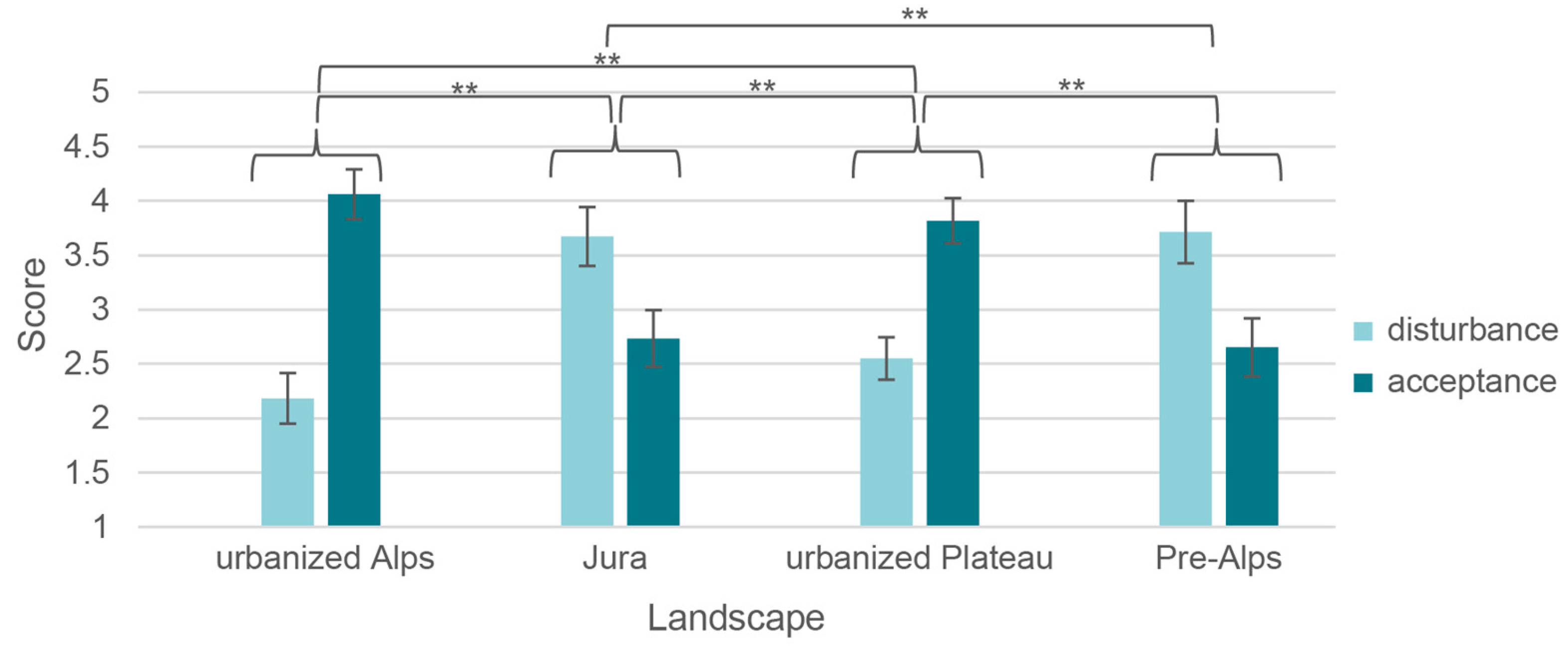
  • In near-natural landscapes power lines are perceived as more disturbing and are less accepted than in human-influenced landscapes.
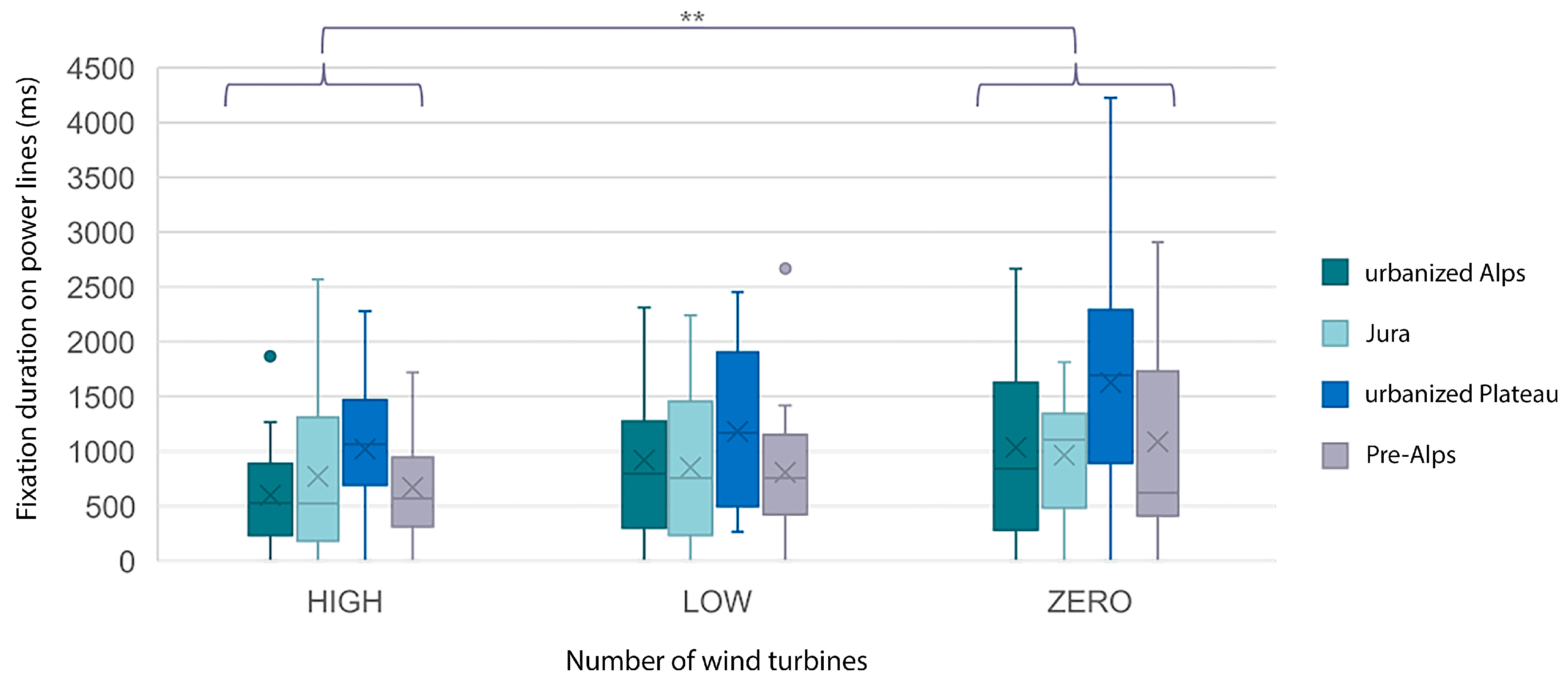
  • Power lines in combination with many wind turbines are perceived as less disturbing and are better accepted than without or few wind turbines.
The results are discussed concerning the effectiveness of employing 3D point clouds for investigating the perception of visual landscape impacts of power lines with eye tracking. Finally, recommendations for further research directions are provided.

2. Materials and Methods

3D point cloud simulations served as stimuli in the experiment. In a preliminary study, we tested whether the simulations should be animated or not when using eye tracking for measuring the perception of the power lines’ impact in the landscape contexts and tested the overall procedure. The main study was conducted with animated simulations, and the eye tracking data as well as the participants’ answers on a questionnaire were collected. Finally, this data was statistically analyzed. In the following, further details on the participants, the stimuli generation, the setup of the laboratory, the preliminary study, the questionnaire, the overall procedure of the main study, and the analysis of the results of the experiment are presented.

2.1. Participants

The study involved 23 women and 26 men, aged between 21 and 35 years (M = 25.5 years, SD = 3.74 years), and with a background in geography, cartography, and spatial and landscape planning. Of the participants, 11 held a master’s degree, 22 a bachelor’s degree, and 16 a high school degree as their highest education. Women and men differed significantly in their attitude towards the acceptance of power lines, whereby male study participants were more positive about power lines (F(1,47) = 4.416, p = 0.037, N = 49). There were no significant differences in the attitude towards wind turbines. The participants were not compensated for their participation and took part voluntarily.

2.2. Visual Stimuli Generation

The 3D landscape simulations of four different Swiss landscape types, Jura, Pre-Alps, urbanized Plateau and urbanized Alps, were generated following and adapting the approach of Spielhofer et al. (2017). For specific locations in these landscape types in Switzerland, LiDAR data from airborne laser scanning (ALS) were collected from Swiss cantonal data bases and from terrestrial laser scanning (TLS) in the field. For the latter a RIEGL VZ-1000 laser scanner with up to 1.4 km range and a calibrated Nikon D700 camera mounted on top was used. The TLS data was obtained during June 2017 to have the summer state of the vegetation in all landscape scenes. The airborne LiDAR data was colorized with orthophotos of the respective landscape areas employing the point cloud processing software LIS Pro 3D [30]. The point clouds from terrestrial laser scanning were further processed with the RiSCAN Pro [31] software to register multiple scans recorded for a landscape area and colorize them with the photos taken with each scan. In order to homogenize the color scheme between the four landscape scenes, the colors of the photos were adjusted using Adobe Photoshop CC [32].
The entire landscape scene of each of the landscape types was then set up using the software Cinema 4D [33]. First, a digital terrain model (DTM) of the area to visualize was imported and textured with the respective orthophoto of that area. Then, the post-processed point clouds were imported to these basic scenes with the plug-in LAZPoint 2 [34]. Further, a skybox was created and slightly moving clouds were added for a higher level of realism. In the next step, the scenes were systematically altered with energy infrastructure objects. In all scenes a power line in form of 3D objects (in the format *.fbx) of four pylons and cables was added in the middle ground of the scenes at approximately the same distance from the observer. Finally, for two scenarios 3D objects of either three or ten wind turbines were added, whereby the starting angle of the different rotors was slightly varied for a more realistic representation [35]. The rotors were animated to turn with approximately 10 rounds per minute, which equals a wind speed of about 6 meters per second.
For a ten-second video at 25 frames per second, 250 frames were rendered for each scenario of the four landscape scenes from a pedestrian perspective at a view height of 1.6 m (Figure 1). Using Adobe Photoshop [32] filters adding haze were applied to the frames for designing the image depth of the renderings as realistically as possible. After the editing, the frames were exported using the render video menu, resulting in 12 video clips in *.mp4.

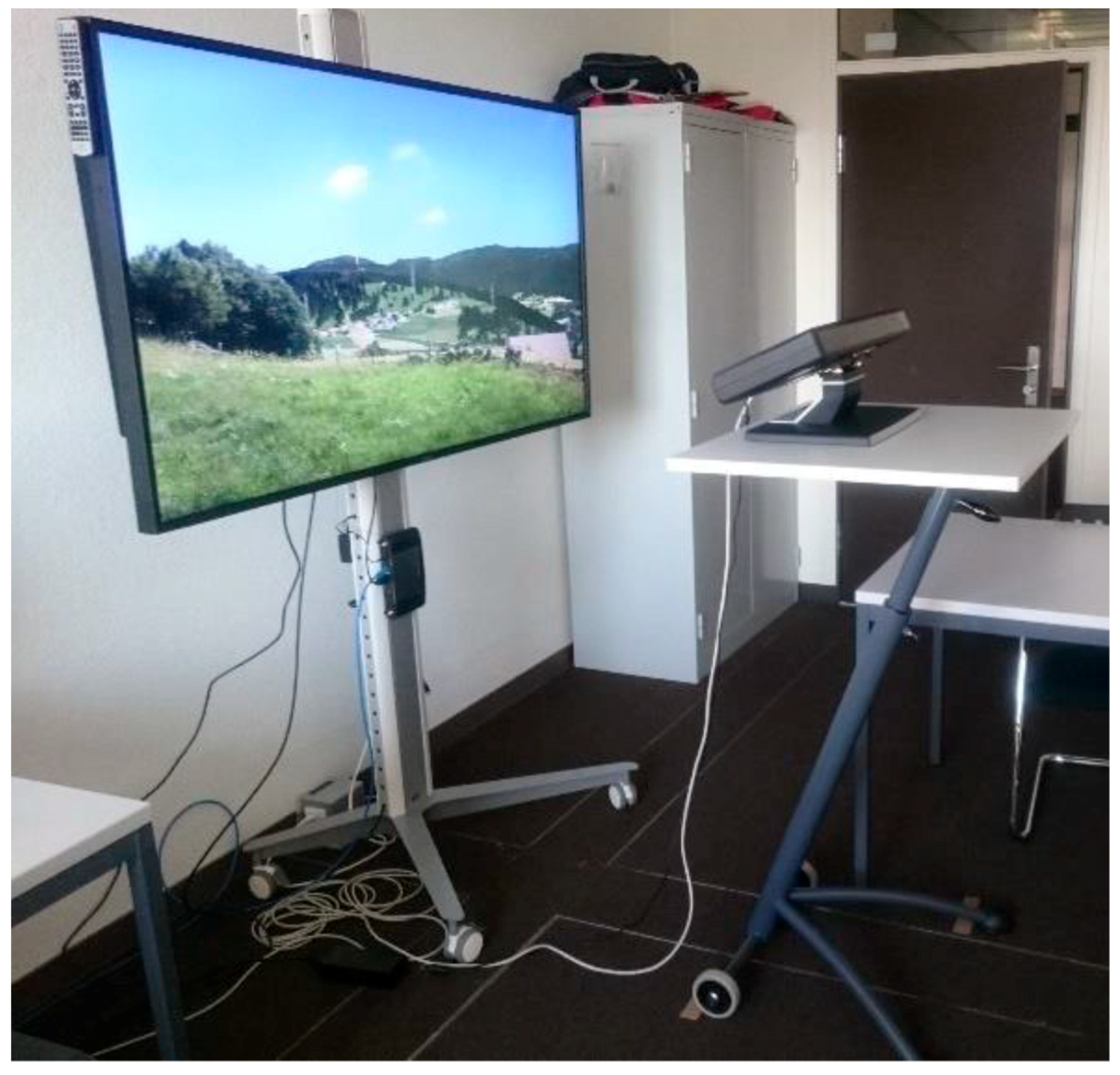
2.3. Setup of the Laboratory

The animated 3D visualizations were presented on a 65-inch monitor at 3840 × 2160 pixel. Participants were standing at a viewing distance of 167 cm, which resulted in a covered visual angle of roughly 46° horizontally and 26° vertically (Figure 2). The eye tracker was placed between the participants and monitor at a distance of 60 cm to track the point of regard (Figure 2). We used a Tobii TX 300 eye tracker, which we set to a sample rate of 300 Hz. In order to collect gaze data and the interaction with the stimuli we used the Software OGAMA 5.0 [36]. Fixation detection is based on the dispersion-threshold-identification (I-DT) method described by Salvucci and Goldberg [37]. We set the time threshold to 100 ms and the minimum dispersion to 20 pixels. At a viewing distance of 167cm this resulted in 1.37° of visual angle which lies well within the range of 1°–2° suggested by Holmqvist and colleagues [16] for fixation detection.

2.4. Preliminary Study

Before designing the overall procedure of the experiment, it was tested whether the animated stimuli with turning rotors and moving clouds were suitable for the intended eye tracking study. Therefore, the differences in the perception of power lines were investigated in still and in animated simulations during a preliminary study. The attention attracted by power lines and by the other elements, i.e., clouds and 10 wind turbine rotors, was analyzed based on the duration of fixation on the areas of interest (AOI) of these elements. The latter are rectangular polygons defined by the experimenter, covering the respective individual element. The fixation durations of the six pre-test participants were summarized for each AOI (i.e., the power lines, the clouds, and the wind turbines) and weighted with the total duration of all fixations to receive the mean duration of the single fixations. The results show that in animated visualizations the fixation duration on wind turbines (1255.67 ms, SD = 888.46 ms) tends to be longer than in static visualizations (759.44 ms, SD = 562.32). However, there were rather no differences in the fixation duration on power lines between animated (1660.63 ms, SD = 870.75 ms) and static visualizations (1382.08 ms, SD = 1067.79 ms). The moving clouds were barely fixated and participants stated that they did not consciously perceive the cloud movement. Based on these results it was found the participants perceive types of power lines in both visualizations with a sufficient duration in order to form an opinion on their visual landscape impact. Furthermore, the wind turbine rotors would turn also in the real landscape and, hence, a higher level of attention to the wind turbines is a rather realistic setting.
In addition, it was tested whether the recording of eye tracking data makes sense while participants are answering questions on their perception and acceptance of the power lines and wind turbines in the presented landscape scenes. As the captured eye tracking data was still quite accurate and the results reasonable, this setup was found feasible.

2.5. Questionnaire

During the main experiment the participants answered different kinds of questions (Table 1). The first set consisted of questions about the liking of the landscape and about disturbing elements. These questions were asked orally during the guided perception part of the eye tracking survey, which means that the participants were given a task directing their gazing behavior [25]. The second set focused on how much the participants felt disturbed by the power lines and wind turbines and how much they accept these infrastructures. The liking of the landscape as well as the disturbance and acceptance of power lines and wind turbines were rated using a five-point Likert scale. In the last part, the participants answered questions on their attitudes and sociodemographic questions. As eye tracking data may be influenced by how a person is feeling, the participants were also asked whether they felt distracted as well as whether they were energetic or tired during the experiment. The latter two questions help in explaining data that is not sufficiently accurate due to strong variation or deviation from calibration. The second and third part of the questionnaire was prepared as web page with the tool Select Survey [38] and participants filled it in using a tablet.

2.6. Procedure of the Main Study

In advance of the experiment, the participants received an information sheet on the course of the study and gave their consent to participate. They also had the opportunity to ask questions about the experiment. Then, each participant performed a five-point calibration to adjust the eye tracker to individual differences. Furthermore, after each task we provided a test image to the participant in order to detect fixation drifts and to ensure a consistent tracking quality among participants. In addition, each instruction screen displayed a red crosshair that the participant had to fixate before the stimulus was presented. Therefore, each participant started exploring the different landscapes from the same position.
In order to capture the free and the guided perception of the landscapes with the eye tracking, the participants were shown the landscapes in several rounds (Figure 3). In a first run, the participants were asked to look at the four landscapes without a task. This bottom-up perception enabled an unbiased exploration of the landscape without directing the participants’ attention to specific elements [39]. The eye movements while answering the questions posed by the experimenter, i.e. the guided perception, were recorded in the second run. In a third run without eye tracking, the participants answered the online questionnaire after perceiving the scenes, whereby the still image at the end of each video was still visible while they filled in the online-questionnaire. Finally, they answered the remaining questions.

2.7. Design and Analyses

The present experiment represents a 4 (landscapes: Jura, Pre-Alps, urbanized Plateau, urbanized Alps) by 3 (number of wind turbines: ZERO, LOW, HIGH) mixed factorial design. The combination of the factors landscape (factor A) and number of wind turbines (factor B) resulted in 12 different landscape scenes (Figure 1). The participants saw a visualization for each of the four landscapes examined (factor A). In order to enable a comparison between the landscapes, all four landscapes were rated once by each participant (within-subject design). Further, to prevent effects caused by a different number of wind turbines between the different landscapes, this factor (factor B) was compared between three groups in a between-subject design. The participants in the groups were each shown the four landscapes either without (group ZERO), with three wind turbines (group LOW) or with ten wind turbines (group HIGH). This prevented the study participants from seeing landscapes with different numbers of wind turbines and from focusing on the elements of the landscape with bias. A balanced ratio of the number of participants in the three groups without, with three and with ten wind turbines was achieved by the alternating allocation of participants to the groups.
Based on the fixations, attention heat maps were created with the Software OGAMA 5.0 [36]. The maps represent an attention distribution for each point with X and Y coordinates. The Gaussian distributions of all fixations were calculated, their values added and the amplitude normalized using a two-dimensional kernel to smooth the distribution [36]. Further, for the individual areas of interest (AOI) the number of fixations as well as the total and the mean fixation time were calculated. In order to obtain comparable values between the landscapes, the size of the AOI was kept constant for the power lines and the wind turbines. However, for the wind turbines this was only possible in the scenarios with 3 wind turbines. In the scenarios with 10 wind turbines, AOIs overlapped due to their close grouping, which meant that the total area of the AOIs differed between the landscapes. Therefore, the share of the AOIs in the overall image were weighted by dividing the fixation times by the percentages of their areas in the overall image. In addition, the fixation durations were weighted with the total duration of all fixations to exclude effects due to missing data. The power lines were of the same size in all landscapes and occupied the same area in all landscapes. Therefore, the duration of fixation on power lines was weighted only with the total duration of all fixations. For the results see Table A1 in the Appendix.
The statistical analysis of the data was carried out with SPSS Version 25 [40]. Eye tracking and survey data were analyzed for significant differences between landscape type and energy infrastructure with multivariate analysis of variance (MANOVA). Independent variables were the landscape types, the general landscape characteristics (near-natural or urban), and the number of existing wind turbines. The dependent variables were the assessment of disturbance and acceptance of power lines as well as the liking and coherence of the landscape scenes. Further, correlations between the eye movements and the participants’ answers on the questionnaire were investigated applying Spearman’s rank-order correlation.

3. Results

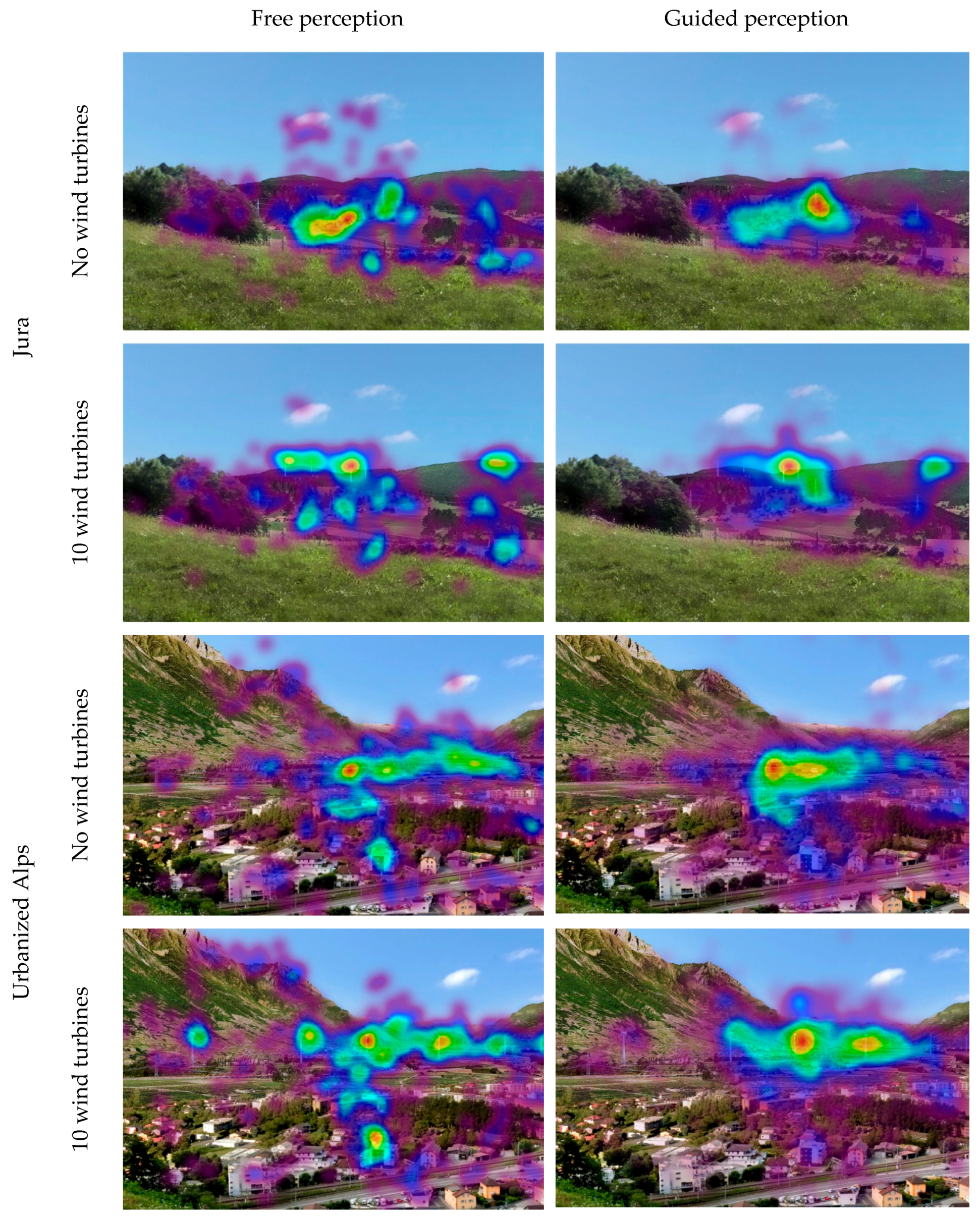
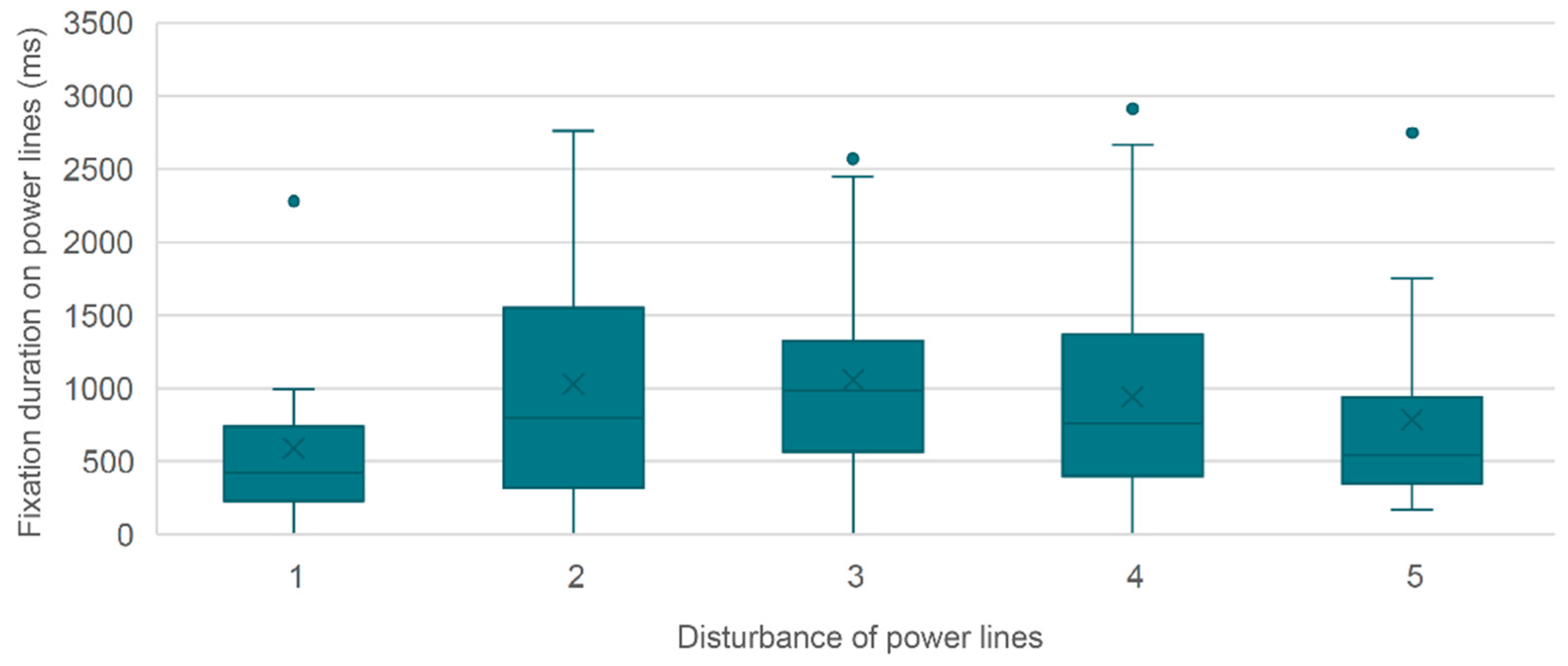
3.1. Attention to Power Lines and Their Perceived Disturbance

The landscape scenes differ in the patterns of eye movements and the distribution of attention depending on the landscape and the number of existing wind turbines. Figure 4 shows the attention maps and gaze patterns in the landscape scenes of the “Jura” and the “urbanized Alps”. Landscapes with wind turbines show a concentration of attention in the areas of wind turbines. However, the power lines are also fixated. The data of the eye movements shows that all areas of the landscape were viewed but an increased density of fixations occurred in the center of the images.
In more than half of the scenes, power lines were mentioned as the first disturbing element (Figure 5). Especially in near-natural landscapes (Jura, Pre-Alps) the power lines were predominantly first mentioned as a disturbing element. If wind turbines were mentioned as disturbing, this was usually the second element. How often power lines were mentioned as disturbing elements varies between landscapes (Figure 5). In urbanized landscapes (urbanized Plateau, urbanized Alps), to a greater extent, other elements than power lines and wind turbines were first mentioned as disturbing. Also, the difference in how often power lines and wind turbines were first mentioned is much smaller compared to the near-natural landscapes.
In landscapes characterized by settlements, the participants often noted infrastructure buildings as disturbing. In particular, the disturbance of industrial facilities and apartment blocks, or more general, urban sprawl was highlighted. Some participants said that due to the urban sprawl they perceived no additional negative impact of the power lines. Another participant found the power lines to be more disturbing than wind turbines due to their continuous, linear form and, hence, cutting effect. In contrast, the wind turbines were seen as selective intervention and several participants mentioned that they perceived the landscapes with groups of wind turbines as coherent.
However, during free perception the fixation time in the AOI of the power lines in a Spearman’s rank-order correlation shows no significant correlation with the participant’s disturbance rating of the power lines (Figure 6). Even if the data are subdivided into urban and near-natural landscapes, no significant differences are visible.

3.2. Landscape Type, Fixation Times and Perceived Disturbance of Power Lines

A multivariate analysis of variance (MANOVA) shows significant differences in the disturbance ratings and the acceptance of power lines between the different landscapes (Figure 7). In all three scenarios with ten, three and without wind turbines, power lines were rated as significantly more disturbing in the near-natural, agricultural landscapes “Jura” and “Pre-Alps” (F(3,192) = 39,742, p < 0.001, N = 196) and were accepted less than in the urbanized landscapes (F(3,192) = 36,286, p < 0.001, N = 196). The Bonferroni-corrected post-hoc tests show that the disturbance ratings of the power lines do not differ significantly between the landscapes “Jura” (M = 3.67, SD = 0.14) and “Pre-Alps” (M = 3.71, SD = 0.15) and between the “urbanized Plateau” (M = 2.55, SD = 0.10) and the “urbanized Alps” (M = 2.18, SD = 0.12), respectively.
Spearman correlation analysis shows that in near-natural landscapes, there is a correlation between the disturbance of the power line and the duration until the first fixation in the AOI of the power lines during guided perception (rs = 0.203, p = 0.047, N = 96). The other eye tracking variables show no significant correlations in near-natural landscapes. In Figure 8, the fixation duration on power lines during guided perception and the rating of the disturbance of power lines are given. For the near-natural landscape types no significant relations were identified regarding this aspect due to high variability in the data (rs = 0.081, p = 0.432, N = 96). If only the urbanized landscapes are considered, the proportion of fixation time on the power lines during guided perception correlates with the assessment of the disturbance (rs = 0.265, p = 0.009, N = 96).
In addition, the average duration of a fixation on power lines is higher in urban landscapes if the power lines are assessed as disturbing (rs = 0.247, p = 0.015, N = 96). Further, the proportion of fixation time on power lines during guided perception correlates significantly with the participants’ rating of the importance of protecting the view of the landscape (rs = −0.184, p = 0.031, N = 192).

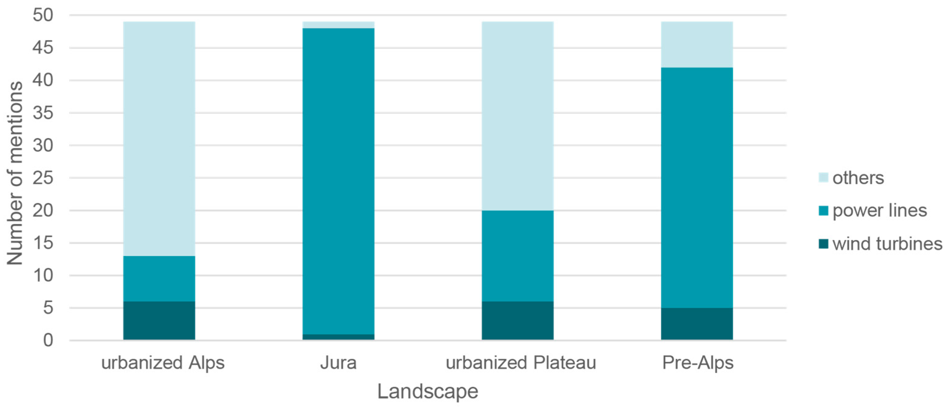
3.3. Fixation Time on Power Lines and Amount of Wind Turbines

For the entire duration of fixation on power lines during free perception in the first ten seconds, a significant difference is visible between scenes with different numbers of wind turbines (F(2,180) = 4,957, p = 0,008). A post-hoc Bonferroni test (p < 0.01) shows that the fixation time on power lines is significantly higher in scenes without wind turbines than in scenes with ten wind turbines (Figure 9). When comparing scenes without wind turbines and scenes with three wind turbines, respectively scenes with three or ten wind turbines, the fixation times on power lines do not differ significantly. In contrast, during the guided perception no significant differences in the fixation times on power lines depending on the amount of wind turbines could be found.

4. Discussion and Conclusions

The goal of the study was to demonstrate an example of a landscape perception study using 3D point cloud simulations with a high level of visual realism as stimuli for gathering gaze behavior recorded by eye tracking. For showing the suitability of these simulations for such studies, we investigated the perception and acceptance of power lines in different landscapes and in combination with different amounts of wind turbines.
The results indicate that the 3D point cloud simulations were appropriate to produce results, which are in line with findings of other research groups using photographs. For example, we found that the gaze patterns differ between urban and near-natural landscapes during free perception. The more intensive exploration of the urbanized landscape scenes can be explained by their higher heterogeneity compared to the rather homogeneous near-natural landscapes (Dupont et al. 2014). However, we could not observe that during free perception more attention is given to power lines although they were regarded as disturbing elements. Hence, the participants’ opinions are not reflected in the eye tracking data. It seems that the participants did not need a long fixation time on the elements they perceived as disturbing to make their opinion. Furthermore, the fixation time on the power lines during free perception does show dependencies with the variation of the amount of wind turbines. However, concerning the disturbance and acceptance rating of the power lines depending on the number of wind turbines these gaze patterns do not provide significant correlations. Therefore, the free image-based gazing could not provide reasonable eye movement patterns explaining the level of disturbance and acceptance of power lines in the different landscape scenes.
In contrast, the gaze patterns during guided perception show correlations with the rated level of disturbance of the power lines and attitudes toward protecting the view of the landscape. However, only in the urban landscape types the fixation time on the power lines correlates with the rated level of disturbance. In the urban landscapes, the power lines were rated generally as less disturbing and are more accepted than in near-natural landscapes, which matches the results of Lienert and colleagues [7].
Overall, differences in acceptance and disturbance between landscapes were identified but the patterns can hardly be investigated with eye tracking only. Whereas the data of the free perception is difficult to interpret, the guided perception is more promising to record clearer differences in eye movements. Further, eye tracking focuses only on the gaze behavior in response to the presented landscape. However, there are further physiological measures, which allow capturing unconscious affective responses such as facial electromyography (EMG), which is regarded as reliable measure for pleasant or unpleasant images [15]. Combining eye tracking with such measures of affective responses might help getting a better understanding of the landscape perceptions and valuations.
For further evaluating the quality of the point cloud simulations as valid stimuli for landscape perception studies, the gaze patterns recorded in the laboratory should be compared with the ones that can be observed at the actual location in the real world [41]. Augmented reality glasses including eye tracking [42,43] could be suitable devices that allow for such studies. This validation is crucial because the 3D point cloud simulations enable a very precise representation of the real-world situation and of intended landscape changes accordingly. This makes them a powerful tool for better informed landscape planning and design, which can actually be informed by the cultural values landscapes give to people.

Author Contributions

Conceptualization, U.W.H., K.M., F.G. and P.K.; Data curation, K.M.; Formal analysis, K.M.; Funding acquisition, A.G.-R.; Investigation, K.M.; Methodology, K.M. and F.G.; Resources, U.W.H., P.K., R.S. and A.G.-R.; Software, F.G.; Supervision, U.W.H., P.K. and A.G.-R.; Visualization, U.W.H., K.M. and R.S.; Writing—original draft, K.M.; Writing—review & editing, U.W.H., F.G., P.K., R.S. and A.G.-R.

Funding

This research was funded by the Swiss National Science Foundation (SNSF), National Research Programme NRP 70 “Energy Turnaround”, grant number 407040_173808/1 (ENERGYSCAPE). Further support was provided by the Swiss Federal Office of the Environment (FOEN), the Swiss Federal Office of Energy (SFOE), the Elektrizitätswerke des Kantons Zürich (EKZ), the Swissgrid AG, the Swiss Federal Institute for Forest, Snow and Landscape Research (WSL), and the Binding Stiftung. The authors bear sole responsibility for the conclusions and findings.

Acknowledgments

We thank all participants for taking part in the survey. Further, we would like to thank Joshu Jullier for his initial idea for investigating the perception and acceptance of power lines in combination with wind turbines in near-natural and urbanized landscapes.

Conflicts of Interest

The authors declare no conflict of interest. The funders had no role in the design of the study; in the collection, analyses, or interpretation of data; in the writing of the manuscript, or in the decision to publish the results.

Appendix A

Table A1. Weighted fixation durations and number of fixations in the areas of interest (AOI) of power lines and wind turbines in the 12 scenarios with different numbers of wind turbines (WT) in four different landscape types.
Number of Wind TurbinesLandscape TypeAOI Power LinesAOI Wind Turbines
Fixations Duration (ms)Number of FixationsFixations Duration (ms)Number of Fixations
AverageStandard DeviationAverageStandard DeviationAverageStandard DeviationAverageStandard Deviation
HIGH (10 WT)ALPVAL601.24495.841.881.362548.481743.527.874.06
JURA770.41746.102.251.943557.482535.417.313.96
PLATURB1020.32653.482.882.091847.94965.607.193.56
PREALP673.07470.732.131.252242.041204.805.692.08
LOW (3 WT)ALPVAL920.12714.602.191.322020.291221.216.504.09
JURA853.43749.732.441.891891.61860.594.632.06
PLATURB1183.30767.453.311.991586.40975.544.751.94
PREALP809.52657.132.382.091149.30847.332.882.21
ZERO (0 WT)ALPVAL1037.79866.052.691.991135.16702.964.942.83
JURA964.60572.062.811.87330.11475.271.001.03
PLATURB1627.111094.494.382.60700.08607.433.192.45
PREALP1088.58919.642.812.00119.45194.280.380.61

References

  1. Smardon, R.; Pasqualetti, M.J. Social acceptance of renewable energy landscapes. In The Renewable Energy Landscape. Preserving Scenic Values in Our Sustainable Future; Apostol, D., Palmer, J., Pasqualetti, M., Smardon, R., Sullivan, R., Eds.; Routledge: London, UK; New York, NY, USA, 2017; pp. 108–142. [Google Scholar]
  2. Schito, J.; Wissen Hayek, U.; Raubal, M. Enhanced multi criteria decision analysis for planning power transmission lines. In Proceedings of the 10th International Conference on Geographic Information Science (GIScience 2018), Melbourne, Australia, 28–31 August 2018. [Google Scholar] [CrossRef]
  3. Verbong, G.; Geels, F. The ongoing energy transition: Lessons from a sociotechnical, multi-level analysis of the Dutch electricity system (1960–2004). Energy Policy 2007, 35, 1025–1037. [Google Scholar] [CrossRef]
  4. Jullier, J. More Acceptance for Power Lines in Switzerland: An Evaluation of the Acceptance Increasing Factors for Transmission Lines in Switzerland. Master’s Thesis, ETH Zurich, Zurich, Switzerland, May 2016. [Google Scholar] [CrossRef]
  5. Battaglini, A.; Komendantova, N.; Brtnik, P.; Patt, A. Perception of barriers for expansion of electricity grids in the European Union. Energy Policy 2012, 47, 254–259. [Google Scholar] [CrossRef]
  6. Lienert, P.; Sutterlin, B.; Siegrist, M. The influence of high-voltage power lines on the feelings evoked by different Swiss surroundings. Energy Res. Soc. Sci. 2017, 23 (Suppl. C), 46–59. [Google Scholar] [CrossRef]
  7. Lienert, P.; Suetterlin, B.; Siegrist, M. Public acceptance of the expansion and modification of high-voltage power lines in the context of the energy transition. Energy Policy 2015, 87, 573–583. [Google Scholar] [CrossRef]
  8. Ribe, R.G.; Manyoky, M.; Wissen Hayek, U.; Pieren, R.; Heutschi, K.; Grêt-Regamey, A. Dissecting Perceptions of Wind Energy Projects: A Laboratory Experiment Using High-quality Audio-visual Simulations to Analyze Experiential Versus Acceptability Ratings and Information Effects. Landsc. Urban Plan. 2017, 169, 131–147. [Google Scholar] [CrossRef]
  9. Spielhofer, R.; Fabrikant, S.I.; Rebsamen, J.; Vollmer, M.; Grêt-Regamey, A.; Wissen Hayek, U. 3D Point Clouds for Representing Landscape Change. J. Digit. Landsc. Archit. 2017, 2, 206–213. [Google Scholar] [CrossRef]
  10. Wissen Hayek, U.; Spielhofer, R.; Grêt-Regamey, A. Preparing 3D Point Clouds as Stimuli for Land-scape Preference Studies: Lessons Learned. J. Digit. Landsc. Archit. 2019, 4. in press. [Google Scholar]
  11. Ulrich, R.S. Human responses to vegetation and landscapes. Landsc. Urban Plan. 1986, 13, 29–44. [Google Scholar] [CrossRef]
  12. Maehr, A.M.; Watts, G.R.; Hanratty, J.; Talmi, D. Emotional response to images of wind turbines: A psychophysiological study of their visual impact on the landscape. Landsc. Urban Plan. 2015, 142, 71–79. [Google Scholar] [CrossRef] [Green Version]
  13. Daniel, T.C. Whither scenic beauty? Visual landscape quality assessment in the 21st century. Landsc. Urban Plan. 2001, 54, 267–281. [Google Scholar] [CrossRef]
  14. Yu, T.; Behm, H.; Bill, R.; Kang, J. Audio-visual perception of new wind parks. Landsc. Urban Plan. 2017, 165, 1–10. [Google Scholar] [CrossRef]
  15. Bradley, M.M.; Lang, P.J. The International Affective Picture System (IAPS) in the study of emotion and attention. In Handbook of Emotion Elicitation and Assessment; Coan, J.A., Allen, J.J.B., Eds.; Oxford University Press: Oxford, UK, 2007; pp. 29–46. [Google Scholar]
  16. Holmqvist, K.; Nyström, M.; Andersson, R.; Dewhurst, R.; Jarodzka, H.; Van de Weijer, J. Eye Tracking: A Comprehensive Guide to Methods and Measures; OUP Oxford: Oxford, UK, 2011. [Google Scholar]
  17. Hayhoe, M.; Ballard, D. Eye movements in natural behavior. Trends Cogn. Sci. 2005, 9, 188–194. [Google Scholar] [CrossRef] [PubMed]
  18. Just, M.A.; Carpenter, P.A. A theory of reading: From eye fixations to comprehension. Psychol. Rev. 1980, 87, 329. [Google Scholar] [CrossRef]
  19. Jacob, R.J.; Karn, K.S. Eye tracking in human-computer interaction and usability research: Ready to deliver the promises. In The Mind’s Eye: Cognitive and Applied Aspects of Eye Movement Research; Elsevier Science BV: North-Holland, Amsterdam, The Netherlands, 2003; pp. 573–605. [Google Scholar]
  20. Çöltekin, A.; Heil, B.; Garlandini, S.; Fabrikant, S.I. Evaluating the effectiveness of interactive map interface designs: A case study integrating usability metrics with eye-movement analysis. Cartogr. Geogr. Inf. Sci. 2009, 36, 5–17. [Google Scholar] [CrossRef]
  21. Ooms, K.; De Maeyer, P.; Fack, V. Study of the attentive behavior of novice and expert map users using eye tracking. Cartogr. Geogr. Inf. Sci. 2014, 41, 37–54. [Google Scholar] [CrossRef]
  22. Kiefer, P.; Giannopoulos, I.; Raubal, M.; Duchowski, A. Eye tracking for spatial research: Cognition, computation, challenges. Spat. Cogn. Comput. 2017, 17, 1–19. [Google Scholar] [CrossRef]
  23. Duchowski, A.T. Eye Tracking Methodology. Theory and Practice; Springer International Publishing: Cham, Switzerland, 2017. [Google Scholar]
  24. Orquin, J.L.; Loose, S.M. Attention and choice: A review on eye movements in decision making. Acta Psychol. 2013, 144, 190–206. [Google Scholar] [CrossRef] [PubMed] [Green Version]
  25. DeAngelus, M.; Pelz, J.B. Top-down control of eye movements: Yarbus revisited. Vis. Cogn. 2009, 17, 790–811. [Google Scholar] [CrossRef]
  26. Itti, L. Models of bottom-up attention and saliency. Neurobiol. Atten. 2005, 576–582. [Google Scholar] [CrossRef]
  27. Batel, S.; Devine-Wright, P.; Wold, L.; Egeland, H.; Jacobsen, G.; Aas, O. The role of (de-) essentialisation within siting conflicts: An interdisciplinary approach. J. Environ. Psychol. 2015, 44, 149–159. [Google Scholar] [CrossRef]
  28. Dupont, L.; Antrop, M.; Van Eetvelde, V. Eye-tracking Analysis in Landscape Perception Research: Influence of Photograph Properties and Landscape Characteristics. Landsc. Res. 2014, 39, 417–432. [Google Scholar] [CrossRef]
  29. Dupont, L.; Ooms, K.; Duchowski, A.T.; Antrop, M.; Van Eetvelde, V. Investigating the visual exploration of the rural-urban gradient using eye-tracking. Spat. Cogn. Comput. 2017, 17, 65–88. [Google Scholar] [CrossRef]
  30. LIS Pro 3D–Point Cloud Processing. Available online: https://www.laserdata.at/lis_pro_3d.html (accessed on 18 April 2019).
  31. RiSCAN PRO 2.0. Available online: http://www.riegl.com/products/software-packages/riscan-pro (accessed on 18 April 2019).
  32. Adobe Photoshop. Available online: https://www.adobe.com/de/products/photoshop.html (accessed on 18 April 2019).
  33. Cinema 4D. Available online: https://www.maxon.net/de/produkte/cinema-4d/cinema-4d/ (accessed on 18 April 2019).
  34. LAZPOINT 2. Available online: https://cinemaplugins.com/c4d-plugins/lazpoint/ (accessed on 18 April 2019).
  35. Manyoky, M.; Wissen Hayek, U.; Heutschi, K.; Pieren, R.; Grêt-Regamey, A. Developing a GIS-based visual-acoustic 3D simulation for wind farm assesment. ISPRS Int. J. Geo-Inf. 2014, 3, 29–48. [Google Scholar] [CrossRef]
  36. Voßkühler, A.; Nordmeier, V.; Kuchinke, L.; Jacobs, A.M. OGAMA (Open Gaze and Mouse Analyzer): Open-source software designed to analyze eye and mouse movements in slideshow study designs. Behav. Res. Methods 2008, 40, 1150–1162. [Google Scholar] [CrossRef] [PubMed] [Green Version]
  37. Salvucci, D.D.; Goldberg, J.H. Identifying Fixations and Saccades in Eye-Tracking Protocols. In Proceedings of the Eye Tracking Research and Applications Symposium (ETRA ’00), Palm Beach Gardens, FL, USA, 6–8 November 2000; pp. 71–78. [Google Scholar] [CrossRef]
  38. ClassApps. SelectSurvey.NET Documentation. Available online: http://www.classapps.com/support_documentation.aspx (accessed on 18 April 2019).
  39. Dupont, L.; Ooms, K.; Antrop, M.; Van Eetvelde, V. Comparing saliency maps and eye-tracking focus maps: The potential use in visual impact assessment based on landscape photographs. Landsc. Urban Plan. 2016, 148, 17–26. [Google Scholar] [CrossRef]
  40. Downloading IBM SPSS Statistics 25. Available online: https://www-01.ibm.com/support/docview.wss?uid=swg24043678 (accessed on 18 April 2019).
  41. Cottet, M.; Vaudor, L.; Tronchère, H.; Roux-Michollet, D.; Augendre, M.; Brault, V. Using gaze behavior to gain insights into the impacts of naturalness on city dwellers’ perceptions and valuation of a landscape. J Environ. Psychol. 2018, 60, 9–20. [Google Scholar] [CrossRef]
  42. TOBII VR. Discover New Possibilities with Eye Tracking in VR. Available online: https://vr.tobii.com/ (accessed on 18 April 2019).
  43. Viewpointsystem. The VPS 19 Experience. Available online: https://viewpointsystem.com/en/products/ (accessed on 18 April 2019).
Figure 1. Renderings of the four different landscapes with power lines and different numbers of wind turbines employed for the experiment. (3D visualization: Reto Spielhofer, Ulrike Wissen Hayek and Kilian Müller).
Mti 03 00040 g001
Figure 2. Arrangement of the equipment for the eye tracking study. (Photo: Kilian Müller 2018).
Mti 03 00040 g002
Figure 3. Steps of the overall procedure of the experiment.
Mti 03 00040 g003
Figure 4. Attention heat maps for the landscape scenes of the “Jura” and the “urbanized Alps” perceived in the first ten seconds (free perception) and during the guided perception without wind turbines and with ten wind turbines.
Mti 03 00040 g004
Figure 5. Disturbing element that was first mentioned, depending on the landscape.
Mti 03 00040 g005
Figure 6. Total fixation time during free perception in the areas of interest (AOI) of the power lines as a function of the rated disturbance of the power lines (1 = not at all disturbing, 5 = very strongly disturbing).
Mti 03 00040 g006
Figure 7. The degree of disturbance of power lines differs significantly between urbanized (Plateau/Alps) and near-natural landscapes (Jura, Pre-Alps).
Mti 03 00040 g007
Figure 8. Proportion of the fixation duration on power lines during guided perception correlated with the rating of the disturbance of power lines for near-natural and urban landscape types.
Mti 03 00040 g008
Figure 9. Fixation time during free perception in the AOI of power lines depending on the landscape and the number of wind turbines.
Mti 03 00040 g009
Table 1. Questions of the survey asked during guided perception (1), without eye tracking after the landscape perception (2), and at the end of the study (3–4).
1. Perception of the landscape scene
1.1
How much did you like the landscape scene?
Rating scale from “1 = not at all” up to “5 = very much”
1.2
How coherent did you find the landscape scene?
Rating scale from “1 = not at all” up to “5 = very coherent”
1.3
Which elements did you find disturbing in the landscape scene?
Please enumerate.
2. Perception and acceptance of power lines and wind turbines
2.1
How strongly did you feel disturbed by the power lines in the landscape scene?
Rating scale from “1 = not at all” up to “5 = very strongly”
2.2
How strongly did you feel disturbed by the wind turbines in the landscape scene?
Rating scale from “1 = not at all” up to “5 = very strongly”
2.3
How acceptable did you find the power lines in the landscape scene?
Rating scale from “1 = not at all” up to “5 = very strongly”
2.4
How acceptable did you find the wind turbines in the landscape scene?
Rating scale from “1 = not at all” up to “5 = very strongly”
3. Attitudes
3.1
How important is the expansion of renewable energy sources in Switzerland to you?
Rating scale from “1 = not at all important“ up to “5 = very important“
3.2
How important is the protection of the view of the landscape to you?
Rating scale from “1 = not at all important“ up to “5 = very important“
3.3
Are you in favor of more wind turbines being built in Switzerland?
Rating scale from “not at all“ up to “5 = absolutely“
3.4
Should power lines be built as underground cables in case of a new power line construction or renewal of an existing one, even if this leads to considerable additional costs?
Rating scale from “1 = not at all“ up to “5 = absolutely“
3.5
Are you concerned about negative health effects of power lines?
Rating scale from “1 = not at all concerned“ up to “5 = very concerned“
3.6
Do you find power lines generally annoying?
Rating scale from “1 = not at all annoying“ up to “5 = very annoying“
3.7
How realistic did you find the landscape scenes?
Rating scale from “1 = not at all realistic“ up to “5 = very realistic“
3.8
Are power lines visible from your living environment?
Yes/No
3.9
Would you accept building a power line in your neighborhood?
Rating scale from “1 = certainly not accept“ up to “5 = certainly accept“
3.10
Would you accept building a wind turbine in your neighborhood?
Rating scale from “1 = certainly not accept“ up to “5 = certainly accept“
4. Sociodemographic aspects
4.1
Age: (Enter a number)
4.2
Gender: (F/M)
4.3
Highest education: (None/High school/Apprenticeship/Matura/
University (Bachelor)/University (Master))
4.4
In which living environment did you grow up? (City/Urban agglomeration/Rural area)
4.5
Post code of the place where you grow up: (Enter a number)
4.6
In which environment are you living at the moment? (City/Urban agglomeration/
Rural area)
4.7
Post code of the place where you are living at the moment: (Enter a number)
4.8
Did you get enough sleep last night? (Yes/No)
4.9
Were you physically or psychologically distracted during this study? (Yes/No)
4.10
How tired or energetic do you feel? (Very tired/Rather tired/Normal/Rather energetic/Very energetic)
4.11
Further comments and notes: (Enter a text)

