Article

Development of the Cultural Landscape of the Slovak Enclave Mlynky (Pest County, Hungary) and the Possibilities of Its Sustainable Present Use

by
Peter Chrastina
1,
Bohuslava Hrončeková Gregorová
2,* and
Pavel Hronček
2
1
Department of Historical Sciences and Central European Studies, Faculty of Arts, University of Ss. Cyril and Methodius Trnava, Námestie J. Herdu 2, 917 01 Trnava, Slovakia
2
Department of Geography and Geology, Faculty of Natural Sciences, Matej Bel University in Banská Bystrica, Tajovského 40, 974 01 Banská Bystrica, Slovakia
*
Author to whom correspondence should be addressed.
Urban Sci. 2025, 9(9), 357; https://doi.org/10.3390/urbansci9090357
Submission received: 17 June 2025 / Revised: 1 August 2025 / Accepted: 3 September 2025 / Published: 8 September 2025

Abstract

The landscape of Mlynky Village, situated in the north–northwest part of Pest County, is characterized by preserved areas of historical cultural landscape and monuments, which were created or rebuilt mainly by Slovak colonists’ activities. The aim of this study was the cultural–ecological characterization of the Slovak enclave Mlynky territory and the reconstruction of the land use (historical land use), with an emphasis on the period from the mid-18th century (from the founding of the village on the land of the Pauline monastery) to 2022. We used the findings on land use changes to develop an integrated landscape management approach, which we present as two framework proposals. They aim to coordinate the development of anthropogenic activities in the present while preserving the cultural–historical potential of the studied area (rescue, revitalization, and protection of selected landscape archetypes) since the natural beauty and historical values of the landscape of the studied area have been protected since 1997 by the legislation of the Danube–Ipoly National Park. The research results also confirm the importance of natural driving forces that played a fundamental role in cultivating the local landscape during the period under study. This fact is reflected in the relatively small areas with high anthropogenic use (arable land and permanent grasslands).

1. Introduction

Land use changes resulting from natural or anthropogenic processes are a continuous cycle worldwide. They always depend on the magnitude of the driving force acting on the (historical) landscape in a younger period (earlier developmental stage), which is related to the intensity of the overlap of older layers. The intensity of the overlap determines the extent to which the oldest historical landscape in the studied area is preserved. If the driving forces are anthropogenically influenced or are of an anthropogenic origin, a cultural landscape is created in a given area. The historical cultural landscape can be stable or relatively stable if the younger driving forces are weaker, less intense, or almost zero. Stable cultural landscapes created in the earliest possible history represent an important heritage of human society.
The landscape of the municipality of Mlynky (Hungarian: Pilisszentkereszt) in the northwest of Pest County is a great example. It is characterized by preserved areas of historical cultural landscape and monuments that were created or rebuilt primarily by the activities of Slovak colonists.
The study presents the cultural–ecological and geo-ecological characteristics of the territory of the municipality of Mlynky and documents or reconstructs the use of areas of the local landscape (historical land use), with an emphasis on the period from the mid-18th century (the founding of the municipality by Slovaks and probably also several Moravians from Santov on the lands of the Order of St. Paul the First Hermit) to 2022. The development of historical land use is visualized using thematic maps (from 1783, 1841, 1886, 1941, 1960s, and 2021), a table with the extent of land-use classes, and a scheme.
Proposals for integrated landscape management complement the research results, the aim of which is to harmonize the development of anthropogenic activities at present while preserving the cultural–historical potential of the studied area (rescue, revitalization, and protection of selected landscape archetypes) since the natural beauty and historical values of the mountainous landscape of the studied area have been protected by the legislation of the bilateral Danube–Ipoly National Park since 1997.

2. Study Area

This research and study aimed to evaluate changes in land use and the stability of the historical (cultural) landscape from the mid-18th century to 2022, harmonizing the development of anthropogenic activities while preserving the cultural–historical potential of the studied area and selected landscape archetypes. The studied historical rural landscape represents the cultural heritage of the Slovak ethnic group in a country inhabited by the dominant autochthonous Hungarian population of the then-Hungarian Kingdom.
The studied area, with an extent of 1711 ha, is represented by the municipality of Mlynky, which is located approximately 26 km northwest of Budapest. Administratively, it belongs to the Szentendre District of Pest County (Figure 1). It is located at the junction of the Pilis Mountains (Hungarian: Pilis) and the Visegrád Mountains (Hungarian: Visegrádi hegység). These morphostructures form the mountain rim of the Mlynky Basin (Hungarian: Piliszentkereszti-medence), which is opened along the Hlboký stream (Hungarian: Kovács-patak or also Dera-patak) to the southeast by the breakthrough valley of Szurdokvölgy [1,2].
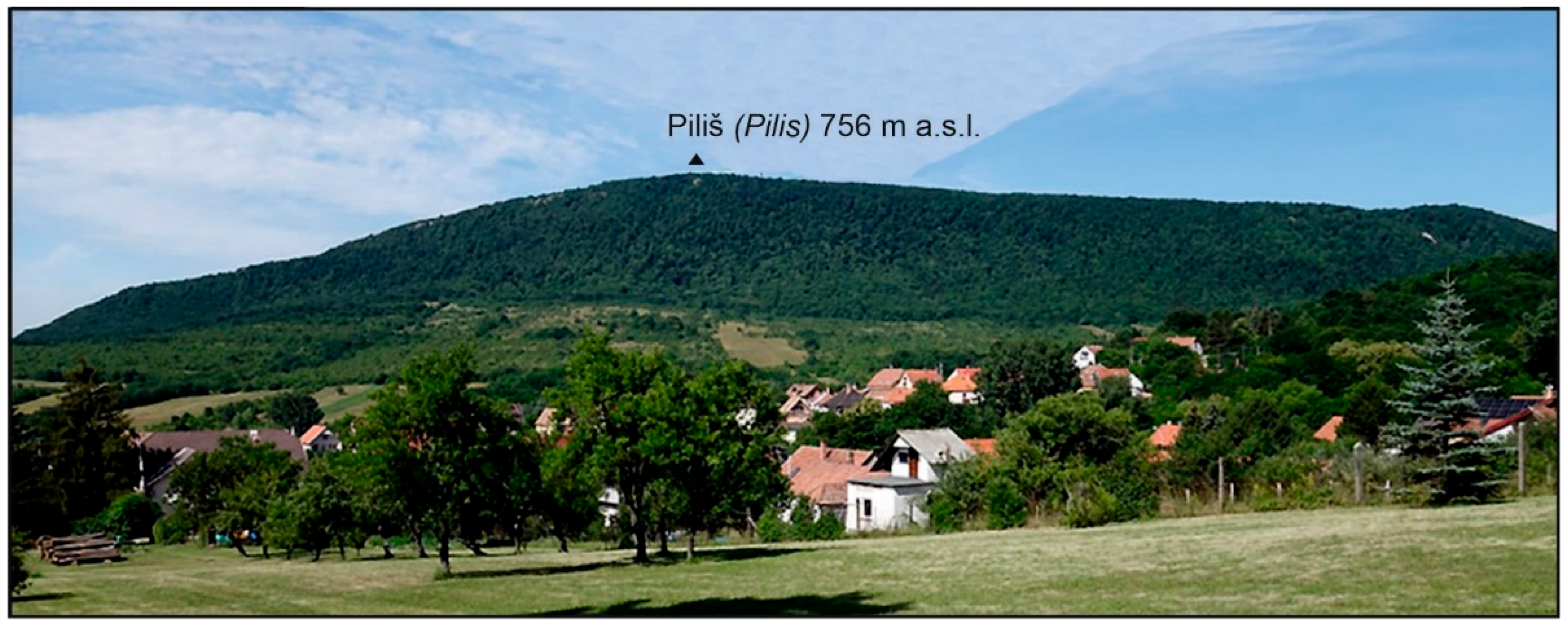
The Pilis Mountain massif (Figure 2) in the Mlynky area is built of limestones, while the Visegrád Mountains (Figure 3) are built of andesites, dacites, and their volcaniclastics (tuffs and tuffites). The basin is covered with loess and loess clays [3,4].
The erosion–denudation georelief of the basin is slightly undulating. The fluvial georelief here is represented by the floodplain of the Hlboký stream cut into the loess bedrock. Several cave systems are underground in the Pilis Mountains and the Szurdokvölgy Gorge. Quarries and settlement terraces represent the anthropogenic georelief in the Mlynky area. In the mountainous landscape of the Visegrád Mountains, there are also dikes and low stone walls (rúny) created by collecting and depositing stones from fields and vineyards [5].
From the point of view of climatic and geographical typification [6], the southeast of the studied area occupies an area of a moderately warm basin climate with a large temperature inversion. It is moderately dry, with an average annual temperature of 9.5 °C and an annual precipitation of about 500 mm. Pilis and the Visegrád Mountains belong to the warm, respectively moderately warm (highest positions above 600 m a.s.l.) mountain climate with a slight temperature inversion. The climate in the mountains is humid, with an average annual temperature of 8 to 9 °C and a total precipitation of 600–700 mm [1,2,7,8]. The number of days with snow cover is unstable and corresponds to the weather in winter when hoarfrost also occurs [9]. Pilis and the Visegrád Mountains’ location and altitude affect air masses’ movement over the studied area, which lies in the precipitation shadow of specific morphostructures [5]. This phenomenon reflects the overall more arid (drier) nature of the local climate.
The Hlboký stream with a rain–snow runoff regime drains the studied area. It reaches its maximum water level in February to April and its minimum in September [10]. During more extended periods without precipitation, it has little water, and in the Szurdokvölgy Gorge, it even dries up (its waters seep through the weathered limestones to the depth). The groundwater, which is formed in the limestones of the Pilis Mountains, is hard. The yield of numerous karst springs, e.g., Klášterová studienka (Hungarian: Klastrom-kút) or Golvavá studienka (Hungarian: Golyvás-kút), fluctuates. Several fissure springs with groundwater from the volcanic rocks of the Visegrád Mountains also spring up in the municipality. Their yield varies and depends on the size and permeability of specific fissures. The well-known ones are Tri stoky (Hungarian: Hármas-forrás), Studená studienka (Hungarian: Hideg-f.), Chylová studienka (Hungarian: Kanyargos-f. or Chilló-kút), and Liesková studienka (Hungarian: Szent-k.). The groundwater from these sources is soft and characterized by a low content of mineral substances [5,11].
The landscape of the municipality of Mlynky is mainly covered by loamy soils with a humus content of 1.6 (mountain area) to 2.5% (basin). In the basin, luvisems and small areas of pseudogleys are widespread on loess and loess clays. Fluvisems and gleys have developed on the floodplain of the Hlboký stream. In the built-up part of the village are anthropogenic soils, cultisols, and anthrosols [12,13]. The soil types of the mountain rim of the studied area are represented by skeletal rendzinas (Pilis) and Cambisols (Visegrád Mts.) [14].
The real (current) vegetation of the mountain landscape of the studied area is represented by anthropogenically influenced oak and oak–hornbeam forests with an admixture of beech. These are partly young forests (potentially with pasture forest relics) created by human economic activity in the 19th to 20th centuries. Specifically, the stands are characterized by a higher proportion of hornbeam (a result of selective logging of oak) and the occurrence of non-native tree species, white locust (Robinia pseudoacacia), or sweet chestnut (Castanea sativa). In the past, deforested areas were covered by a mixed stand of conifers (so-called moors and firs) with Scots pine (Pinus sylvestris), spruce (Picea excelsa), silver fir (Abies alba), and deciduous larch (Larix decidua). Selected areas are covered by a patchwork of hanging birch (Betula pendula) [5].
The basin is home to widespread vegetation of anthropogenic or anthropogenically influenced biotopes. In addition to field crops, extensive weed growth, scrub (black elderberry—Sambucus nigra, common lilac—Syringa vulgaris), and various synanthropic trees (e.g., acacia and Canadian poplars) can be found here.
The natural beauty and historical values of the mountainous landscape of the studied area have been protected within the Danube–Ipoly National Park (Hungarian: Duna–Ipoly Nemzeti Park) since 1997.

3. Materials and Methods

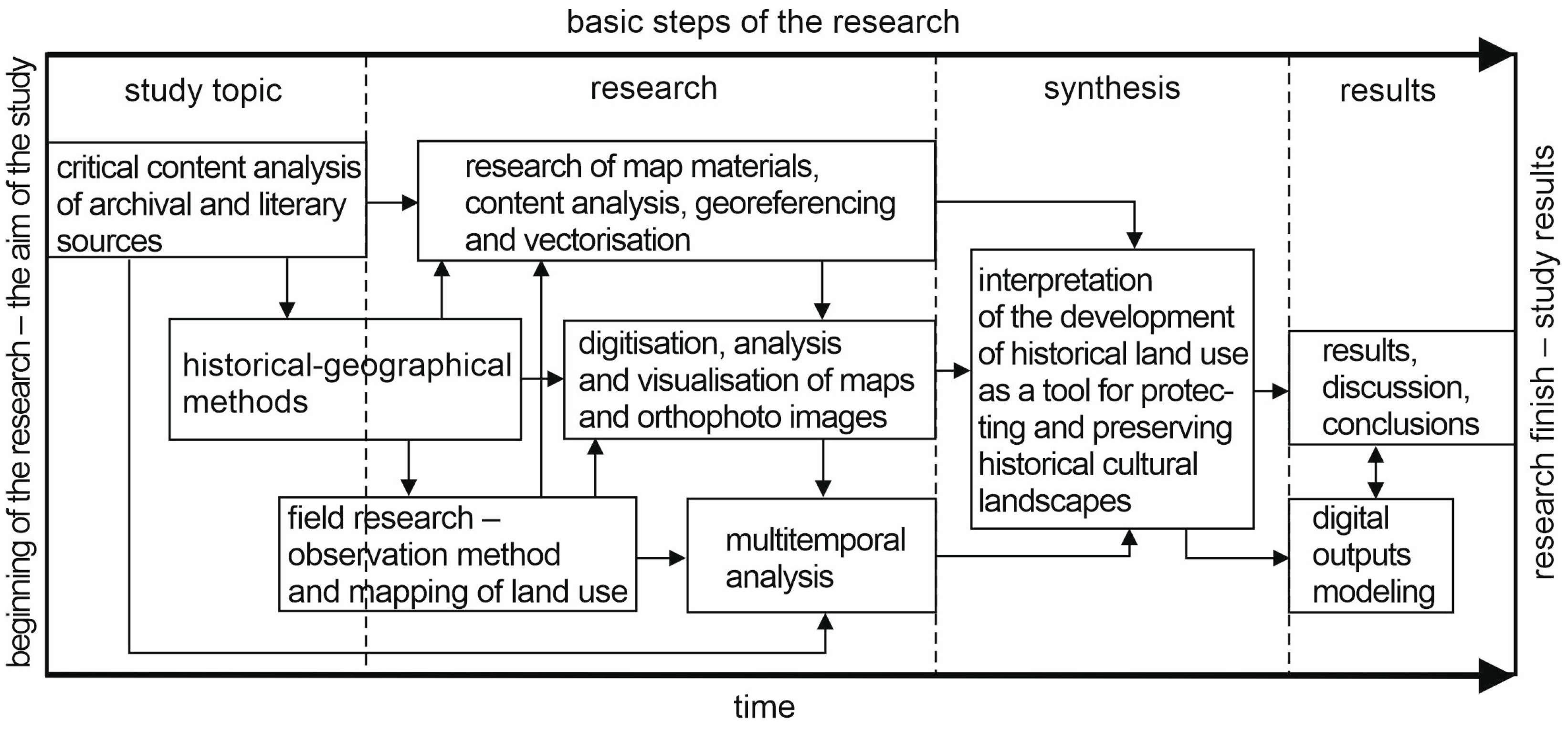
This issue’s interdisciplinary nature reflects the diversity of sources and specific working methods. The chosen procedure aligns with the study’s objectives and consists of several directly related and simultaneously implemented steps or stages (Figure 4).
The heuristics of the information database, or, rather, the critical analysis of archival and literary sources, led to the creation of a background literature review on the topic under study using the bibliometric method [15,16,17]. Geographers and landscape ecologists mainly address the issue of long-term changes in the landscape or its specific components, e.g., Fescenko, Nikodemus, and Brūmelis [18]. An integrated (interdisciplinary) approach to the historical land use of Slovak enclaves in Hungary, Romania, and Serbia was applied by M. Boltižiar, P. Chrastina and J. Trojan [19], P. Chrastina [20,21,22], P. Chrastina and M. Boltižiar [23,24], P. Chrastina et al. [25], P. Chrastina, J. Trojan, and P. Valášek [26], and P. Chrastina, K. Křováková, and V. Brůna [27].
As for the studied area, the nature, history, and cultural aspects of the Mlynky area were processed by Papuček [5]. The characteristics of selected components of the natural environment are based on the works of Frisnyák [28], Haas et al. [3], Šomšák [29], and other authors and obtained from thematic maps in atlases. Other titles describe the specifics of settlement of the built-up and non-urban areas of the municipality in the modern era [30,31,32,33,34], the historical road network [35], the history of the extinct monastery [36,37,38], and the use of forests in the Pilis region during the Middle Ages [39]. When working with the literature and maps, we applied methods of historical–geographical research (critical analysis, evaluation, comparison, and interpretation).
We carried out historical and semi-stationary field research using the observation method. An essential aspect of the topic’s processing involved the methods of historical research, particularly critical analysis of historical sources, as well as deductive and comparative historical methods. After conducting historical research, we continued in the summer of 2022 with extensive field research of the historical landscape [40,41,42,43,44,45,46]. Its goal was to map land use in the Mlynky area (by plotting the use of areas in a satellite image from 2021) and identify areas of the historical cultural landscape. The field research also included the production of authorial photo documentation.
Research on map materials, their identification, content analysis, georeferencing, and vectorization was carried out. Old maps and satellite photographs were used to reconstruct historical land use (Table 1). These documents are digitized on https://maps.arcanum.com/en/ (accessed on 8 May 2025) and the Google Earth Pro web application (satellite images from 2021 or 2022).
Digitization, analysis, and visualization of maps and orthophotography images were carried out in a computer environment of geographic information systems (ArcMap 10.4, ESRI program). Following G. Timár et al. [47,48] or G. Timár and S. Biszak [49], the initial georeferencing of maps was carried out in the WGS84 geographic coordinate system. As part of the actual digitization, the maps were reprojected into the S-JTSK coordinate system, in which quantification (calculation) of the area was also carried out [50]. A 2021 digital satellite image from the Google Earth Pro application was modified similarly.
For the purposes of a correct comparison of individual periods (1783, 1841, 1886, 1941, 1960s, and 2021), the current border of the Mlynky municipality was inserted into each map section to enable a comparative analysis of the maps and to evaluate the factors and conditions determining changes in the landscape structure of the studied territory [51] (Figure 5).
Comparative analysis of cartographic sources was performed. In ArcMap 10.4, land-use classes (LUCs) were identified on each georeferenced digital map, and their area was calculated (excluding line layers of watercourses and roads). The comparative analysis yielded historical land use maps (1:25,000), illustrating the use of the local landscape across six periods from 1783 to 2022.
The scale of the 1941 military map and satellite images was smaller than the resulting land use classification on thematic maps. Therefore, their content was generalized.
The multitemporal analysis studied the dynamics of LUCs in the ArcMap 10.4 environment. It assessed the development of LUC areas by statistically processing historical land use areas (numerical and graphical analysis).
Interpretation of the development of historical land use served as a tool for protecting and preserving historical cultural landscapes. The geoecological and cultural–ecological characteristics and an analysis of land use development contributed to the formulation of framework proposals for managing the cultural landscape of the municipality of Mlynky. These proposals aim to protect, stabilize, and preserve the area as a historical heritage site for Slovaks in Hungary. Since 1997, Mlynky has been part of the bilateral Danube–Ipoly National Park.

4. Results

4.1. Cultural–Ecological and Geo-Ecological Characteristics of Studied Area

Alongside farming on arable land, forestry, and quarrying stone for construction, lime production was significant to the economy of the village of Mlynky. Papuček [5] writes that limestone for lime production was obtained, for example, from a quarry in the Hloh massif (Hungarian: Som-h., 412 m a.s.l.), where round limekilns, so-called “pécky”, were built. Only one kiln at the mouth of the Szurdokvölgy valley, located at the confluence of the Léskový and Hlboký streams, has survived to this day. This kiln was built near a limestone wall quarry.
Local masons used andesite from quarries in the Chotárna skala area and its surroundings as a building material. This rock forms the masonry of houses and historical architecture in the village (church and ruins of a medieval monastery). Andesite volcaniclastics (tuffs) used to construct the monastery church were quarried in the broader vicinity of the village in the Visegrád Mts. Earlier (until the first half of the 20th century), there were clay deposits in various parts of the non-urban area. Clay was sourced from them for plastering the ovens and walls of rural houses [5].
The features of the georelief of the studied area largely influenced (and still do today) the character and intensity of anthropogenic activities in the local landscape. For this reason, the oldest part of the built-up area, with houses, gardens, and arable land, is spread over the basin’s dry (drier) areas. The sunny slopes of the Visegrád Mountains in the Kopanica locality were covered with vineyards. The foothills of the mountain rim of the studied area were partially deforested, and there were low-yielding fields with stony soil threatened by erosion.
The oldest phase of colonization of the Mlynky area by Slovak ethnic groups correlates with the cold period of the Fernau oscillation (the so-called Maunder minimum) [52]. Despite the unstable climate, relatively large parts of the studied area were used as arable land and vineyards. The leeward position of the basin part with a drier mesoclimate was suitable primarily for cereals, rye, barley, oats, and wheat. Bundles of long rye (wheat) straw were used to cover the roofs of houses in the 19th century, and baskets were woven from them in winter. Villagers grew various vegetables on the arable land, as well as potatoes, hemp, and pumpkin [5]. Legumes were represented by beans, lentils, peas, and, more recently, chickpeas. Cabbage was an important part of the traditional diet of the inhabitants of Mlynky.
Water resources influenced the development of anthropogenic activities in the local landscape. The relatively low water content of the Hlboký stream throughout the year is reflected in its name “rivulus Mélly patak” (lat. little stream Mlynský potok) on the map from 1771 [53]. Despite the small amount of water, mills for grinding grain were built on its banks. Ponds for water retting were dug near the stream, where hemp tied into sheaves was soaked [5]. In many places in the area’s non-urban parts, water springs were collected in wells (Figure 6). Liesková studienka even became a pilgrimage site with special genius loci.
The agricultural soil fund in the basin consists mainly of loamy luvisols. These soils are the most fertile in the studied area, but their fertility is only average [13]. In addition to cereals, cabbage (historical site: Kapusnice) and hemp (formerly Konopnice) were grown on luvisols. Humans used the low-productive pseudogleys in the ravines as fields or grasslands, which were later (apparently in the second half of the 20th century) overgrown with bushes.
Pastures developed in the wetter areas of the floodplain soils. Enclaves of submontane floodplain forests influenced by anthropogenic factors covered heavy, clayey luvisols on the banks of watercourses.
Humans created anthropogenic soils in the gardens and courtyards of family houses in the past. These soils are usually more fertile than the natural soils of the luvisol and cambisol types. Vegetables, fruit trees, decorative vegetation, and synanthropic invasion species grow on anthrosols and cultisols.
Expanding the field areas to the slopes of Pilis and Visegrád Mts. solved the problems of low plant yields and relative overpopulation in the studied area. Erosion limited the sustainable use of skeletal rendzinas and cambisols in the mountainous landscape. At the beginning of the 21st century, rendzinas and cambisols were important forest soils.
The activities of the population colonizing the Mlynky area during the 18th century also influenced the structure of the local forests. The so-called “wandering logging” was oriented toward oak, and less toward ash. Roundwood or lumber from these trees was used in construction, producing work tools (ash), technical equipment for mills, etc. Other types of trees, e.g., hornbeam, elm, or beech, provided firewood (for households or the production of quicklime in kilns), and charcoal was produced from them. Parts of the logged areas were covered by Scots pine, while others began to be used as extensive meadows and pastures. In the last century, conifers (spruce, pine, larch, and fir) were planted in the Dedinské, Jama, and Dubiny localities, forming connected stands of moors and firs. Even earlier (the 19th century), thanks to human introduction, white locusts and sweet chestnuts appeared in the forest landscape.
After the declaration of the Danube–Ipoly National Park in 1997, forest communities have fulfilled a protective and eco-stabilizing function. Protection of nature and landscape also encompasses wild animals whose populations are not regulated. Overpopulated ungulate game damages arable land, young fruit trees, and crops in fields and home gardens without fencing. Crop cultivation in the basin (located in the protective zone of the NP) is, therefore, limited to plots on the edges of the built-up area (Odpotočné role) and fenced land in the village.

4.2. Land Use Development of Studied Area from Mid-18th Century to 2022

The region’s economic revival occurred after the liberation of Esztergom in 1685 and Buda in 1686 from Turkish rule, followed by the signing of the Peace of Karlowitz in 1699. In the late 1840s, the Pauline order acquired the deteriorating property of Pilis Abbey [5,36]. The income from the acquired property ensured the renewal of the extinct settlement and the intensification of land use in the advanced stage of succession.
The settlement of the Sub Monte Pilisiensi site (lat. Pod Pilišom, or Pod Pilišskou horou) by ethnic Slovaks and possibly Moravians from the neighboring Santov occurred by 1747 [5,54]. As part of internal colonization, six families (four peasants with livestock and two lodgers) moved to the lands of the monastic order. A year later (1748), fifteen families lived here; there were twenty in 1752. In the following period, the village was settled by Slovaks from the Trnava area in the Bratislava Stool and the territory of the Nitra Stool. One hundred families (including Germans) lived there in 1760 [30,31,32].
The first (and possibly the second) generation of colonists lived in makeshift huts [5], which were gradually replaced by clay architecture on a stone foundation. The material for the foundations of the houses (and probably also for the chapel) was obtained from the remains of the ruins of a medieval Cistercian monastery [36].
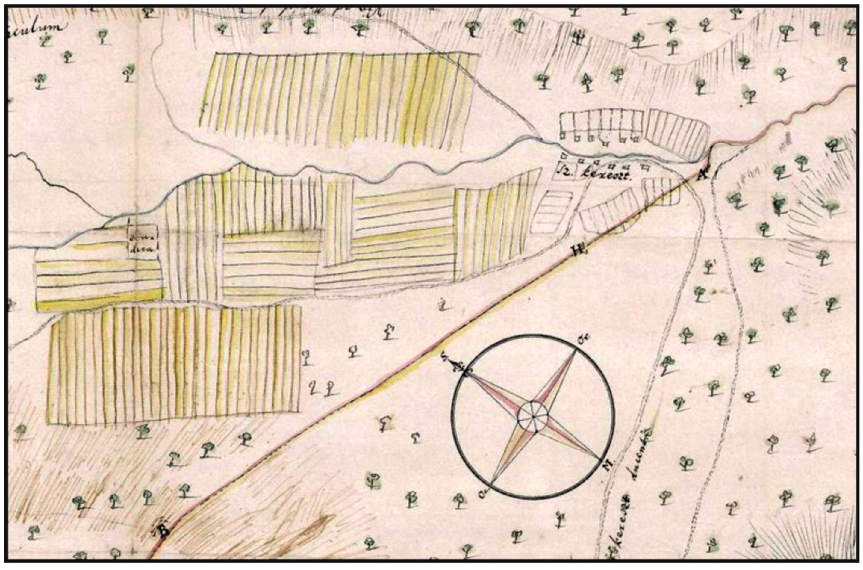
The ploughshare and bunch of grapes on the municipal seal from 1758 confirm that the main occupation of the inhabitants of the settlement of Sancta Crucem, or also Sancta Crux (Slovak: Svátý Kríž; Hungarian: Szent-Kereszt), was farming and working in the vineyard. Areas with arable land (marked in yellow and hatched in Figure 7) were mainly in the basin, extending to the mountain slopes’ foothills. The area of the former monastery complex (marked on the map as Rudera; Latin: ruin) was potentially used as a meadow or pasture. In addition to vineyards, permanent crops were represented by home gardens in the urban area. During this period, Mlynky, or Sancta Crux, was developed as a stream-side terraced village with houses located on both sides of the Hlboký stream and the street (today Slovácká ulica, or Kossuthova ulica). The intensively used areas in the hinterland of the rural settlement were surrounded by the forests of the Pilis and Visegrád Mountains with a network of field roads (Figure 7).
Selected data from the Theresian Land Register allow us to outline the historical land use of the studied area in 1770. The landowner of Mlynky was the Pauline monastic order at the Pest convent. The village consisted of 5.63 serf estates with an area of 444 acres (approximately 177.6 ha). According to the URBARIUM of 1767 online database [56], there lived 34 peasants (vilinus), 49 lodgers (inquilinus) with a house and a small plot of land, and 11 propertyless (subinquilinus).
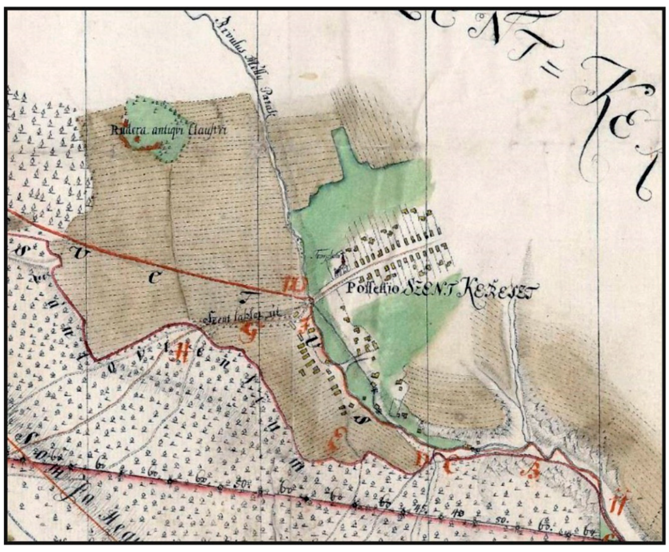
Although the Theresian Land Register of Mlynky mentions two stream mills, a tavern and a slaughterhouse, it does not mention vineyards. In addition to indirect evidence from the municipal seal, vineyards are confirmed by the 1770 Census, when they reached an area of 39 1/2 acres, i.e., 13 ha. The report on the area of the scattered settlements on the Szent Kereszt property (1773), in turn, states 192 3/4 acres (approximately 77.1 ha) of land in the rugged terrain of the mountain slopes [5]. In addition to the above sources, the view of the contemporary use of the land is complemented by Ball’s map from 1771 (Figure 8). According to this cartographic source, the houses with the church and cemetery in the Possessio Szent Kereszt (lat. Majetok Svátý Kríž) are concentrated along the road (Main Street) from Santovo. The development of the street near Hlboký stream has, meanwhile, become a secondary urban axis of the rural settlement, which, from a morphogenetic aspect, is represented by the road village. Several objects are also visible in the back of the farmyards, which were used as gardens, probably farm buildings (barns). Grasslands (marked in green) spread around the urban area, which continued along Slovácká Street to Hlboký stream. Three mills worked on the small watercourse Rivulus Mélly Patak (Latin: Riečka Mlynský Potok) below Slovácká Street (two of them were built on a mill flume). The area with the remains of the “ruins of an old monastery” (Rudera antiqui Claustri) northwest of Mlynky was also used as meadows and pastures. The locals potentially used the crafted stonework from the vanished building to construct their dwellings [36].
The fields (marked in brown) were mainly located in the basin, from where they extended to the foothills of the adjacent mountains. Deciduous forest covered the steep slopes of the Pilis and the Visegrád Mountains.
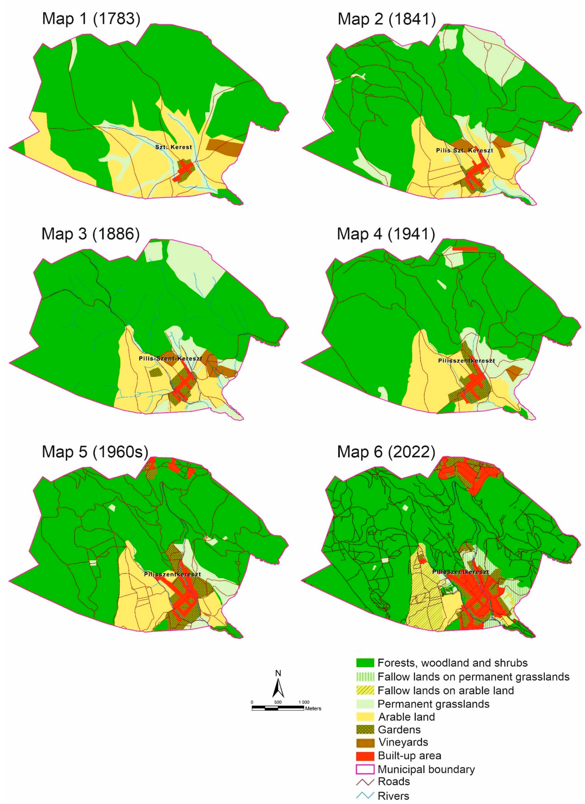
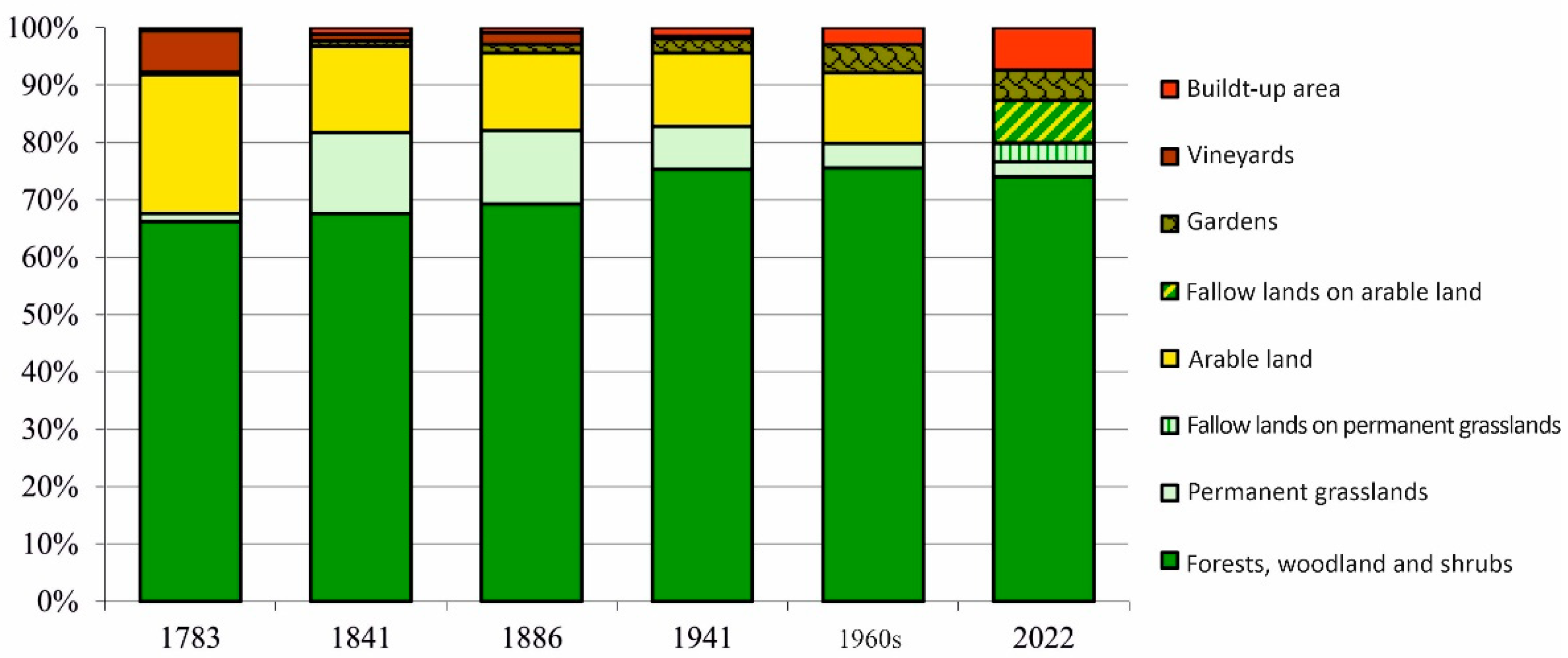
Using computer digitization, we processed the visualization of land use changes in the studied area from 1783 to 2022. The obtained results are documented by six map outputs from individual time horizons in Figure 9. The dynamics of these changes are approximated by Table 2 and Scheme 1 with the areas of land-use classes (LUCs) and their relative representation (in %) in the relevant year or time horizon. The analysis of the results allows for a detailed discussion and formulation of conclusions to create proposals for integrated landscape management.

4.3. Analysis of Changes in Land Use of Studied Historical Landscape in Terms of Its Stability

The research results highlight the importance of natural driving forces [57], which played an important role in anthropogenic exploitation of the local landscape during the monitored periods. The impact of anthropogenic land use is reflected in its ecological stability. In Central Europe, ecological stability is most often determined on the basis of two approaches within landscape ecology research [58,59,60,61,62]:
  • As the ratio of relatively stable and relatively unstable areas;
  • Based on the area of landscape elements, taking into account their landscape–ecological significance.
In our research, emphasis is placed on the objectivity of the assessment of the ecological stability of the landscape resulting from the degree of anthropogenic transformation of individual landscape elements (first approach). Therefore, the ecological stability is assessed based on two indicators: the coefficient of anthropogenic influence of the local landscape (Cai) and the coefficient of cultural landscape originality of the studied area (Cclo). The Cai coefficient represents an assessment of the intensity of human impact on the landscape and its development. For this purpose, the Cai was defined as the ratio of areas with high intensity of use, or high anthropic pressure, to areas with lower intensity of use [63]. It takes values from 0, with no upper limit. Value 1 is achieved when both types of areas are in balance. A value higher than 1 means that areas with a high intensity of anthropogenic use (H) (arable land, settlements, built-up areas, and arable crops) prevail. In the case of a predominance of less intensive areas (L) (forest, permanent grasslands, water area, alternatively also woodland and shrubs, and wetland), the coefficient value approaches 0 [64]. The coefficient Cclo expresses the ratio of relatively positive (forest and permanent grasslands) and relatively negative landscape elements (arable land) [65]. If this ratio exceeds a value of 1, the landscape is stable, and conversely, the closer it approaches 0, the landscape becomes unstable [66]. A similar methodology was successfully applied in the research of another Slovak enclave in Hungary, the municipality of Čív, located in Komárno-Esztergom County [67]. The calculation, study, and interpretation of both coefficients allowed us to derive the following trends and specifics regarding the historical land use of the municipality of Mlynky.
Forests, woodland, and shrubs (WaS). Thermophilic oak forests, or oak forests with an admixture of beech and stands of invasive trees and shrubs, covered approximately 66% (1134.6 ha) of the studied area in 1783. From the first period until the 1960s, the analyzed land-use class area gradually increased to approximately 1294 ha (75.6%). In 2022, the area of forests and WaS reached approximately 1266 ha (74%), representing an increase of less than 10 percentage points compared with the first period (Table 2, Scheme 1).
The continuous increase in the area of forest and WaS is mainly related to the phenomenon of succession of arable land, permanent grassland (PG), and vineyards not used by humans, and the planting of non-native trees (white locust and various conifers) into the landscape in the 19th and 20th centuries. These factors compensated for the decrease in forest areas in the sites of Chotárna skala, or Dobogóš, Trniny, Kopanica, Kohútí vrch, Podpilíšné role, Role pri Novéj kalvárii, Role Za pecáma, etc. After 1997, the nature and landscape protection aspect in the Danube–Ipoly national park territory, and mainly its protection zone, created the so-called “social fallow land” with WaS (Figure 9).
The gradual expansion of the forest area, but especially the expansion of WaS on agricultural land areas, was fundamentally important in explaining the low values of the coefficient of anthropic influence of the local landscape (Cai). The coefficients of originality of the cultural landscape of the studied area (Cclo) indicate its high ecological stability with a minimal share of relatively negative elements (Table 3). The significant increase in the Cclo coefficient in 2022 (up to 409.6) was caused by several factors. During the monitored periods, crop production in the studied area was limited by natural conditions, namely, the steepness of the mountain slopes, the local climate, and soil fertility. After the Danube–Ipeľ National Park was established in 1997, most of the available arable land areas ceased to be used and began to be overgrown with invasive woody plants. By 2022, this trend had resulted in a decrease in the area of fields, permanent grasslands, and vineyards, or in the succession of these areas by forests and woodland and shrubs.
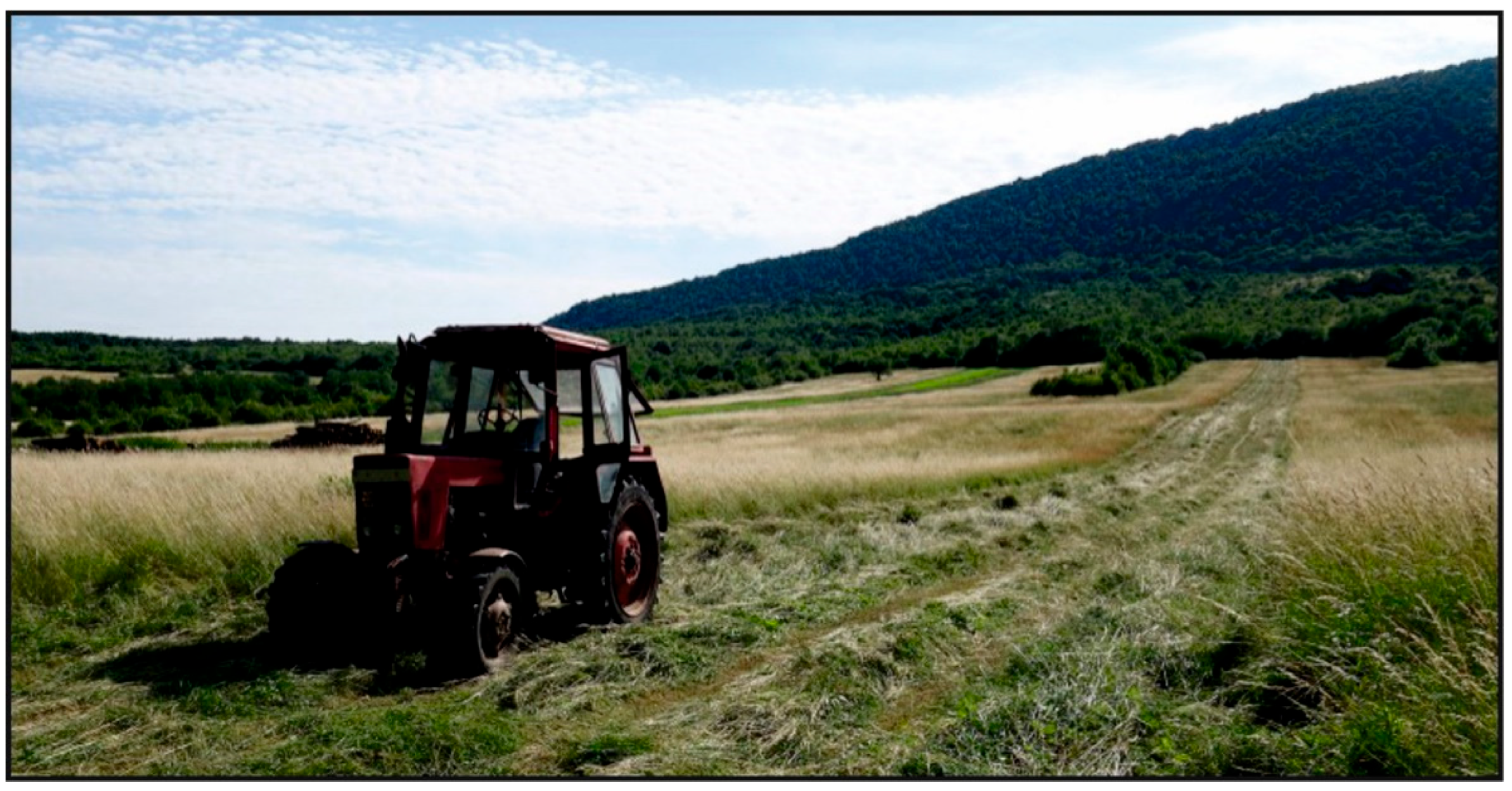
Permanent grasslands (PGs). In the first-time horizon, floodplains of watercourses were used as meadows and pastures (Map No. 1 in Figure 9). In 1783, their area reached 23.3 ha (approximately 1.4% of the area of the studied region). By 1841, the area of land-use class had more than doubled to 241.7 ha (14.1%). This significant increase is related to the deforestation of areas in the mountainous landscape and their transformation into permanent grassland (Chotárna skala/Dobogóš) or the grassing of eroded fields in the basin, which were used for hay collection or as pastures (Map 2 in Figure 9). In the third period (1886), the areas of monitored land-use class decreased by only 1.3% (or 23 ha) with a total area of 219 ha. By 1941, however, the area of meadows and pastures had decreased by as much as 58% (128.4 ha). This phenomenon is probably related to the low numbers of cattle and other livestock in Mlynky and the transformation of selected areas of permanent grasslands into forest and woodland and shrubs, or residential development and home gardens. The trend of reducing the area of permanent grasslands accelerated in the 1960s when another 57% of the areas were afforested and built up. After Hungary joined the European Union (EU) in 2004, most of the meadows and pastures in the non-urban area ceased to be used, and fallows were created on the affected plots. In 2022, a specific land-use class (area of 44.8 ha) was represented in sites such as Odpotočné role and Klášter (Figure 10, Table 2, Scheme 1).
The development of Cai and Cclo in Table 3 shows that meadows and pastures played an important role in maintaining the ecological stability of the Mlynky area’s landscape. Fallows on permanent grasslands and other less intensive land-use classes fulfil this function nowadays.
Fallow lands on permanent grasslands. In 2022, they covered an area of less than 54 ha, about 3.2% of the studied area (Table 2). Maps no. 5 and 6 in Figure 9 show that the succession of permanent grasslands on the slopes of the Visegrád Mountains and Pilis near the urban area formed this extensive LUC.
Arable land. According to Table 2, in the first period (1783), the area of fields reached almost 414 ha (24.2% of the studied area). The areas of luvisols in the basin, or rendzinas and cambisols on the mountain slopes, were used as arable land (Map 1 in Figure 9). By 1841, the area of arable land managed by the three-field system had decreased by 61% to 255.9 ha. This phenomenon is primarily related to the grassing of eroded fields on the slopes of the mountains (Map 2 in Figure 9). Despite the gradual introduction of the alternating system of arable land management, a further decrease in the area of fields by approximately 25.5 ha (1886) and 36 ha (1941) can be observed in the second half of the 19th century until 1941 (Maps 3 and 4 in Figure 9). This trend continued in the 1960s (a decrease of 46 ha compared with 1841). Natural conditions, the inclination of the mountain slopes, the local climate, and soil fertility limited the development of crop production in the studied area. After the declaration of the Danube–Ipoly NP in 1997, most of the available arable land areas ceased to be used and became overgrown with weeds (Map 6 in Figure 9). Such a land use pattern also corresponds with the EU agricultural policy, which emphasizes extensive land use in foothill and mountain areas.
The area of the LUC in question influenced the originality and anthropic load of the local landscape, especially in 1783. Since then, the area of arable land has been decreasing. At first, it was a gradual trend from the second half of the 19th and 20th centuries, which was replaced by an extreme decrease in arable land areas at the turn of the millennium (Scheme 1). These changes, caused by the action of natural and social driving forces of the local landscape development, are also reflected by the Cai and Cclo coefficients in specific periods (Table 3).
Fallow lands on arable land. In 2022, the specific LUC had an area of approximately 126 ha (about 7% of the studied area) (Table 2). Fallow lands on arable land were created by transforming field areas by succession after establishing the Danube–Ipoly NP in 1997. From a spatial point of view, this mainly concerns the western part of the basin landscape and the foothills of Pilis (Maps 5 and 6 in Figure 9).
Gardens and vineyards represent arable crops.
The development dynamics of garden plot areas correlate with the area of village buildings within the built-up area. We also integrated into this LUC the landscaped areas of the recreational area Chotárna skala with park planting on the northern edge of the studied area (Figure 9). The given LUC in 1783 covered 8.4 ha. By 1841, its area had increased to 16.4 ha. In the third and fourth periods (1886 and 1941), the area increased to 28 ha and 42.8 ha. In 2022, the gardens were mapped on an area of 92.7 ha, more than 11 times the area of the specific LUC in the first period (Table 2, Scheme 1).
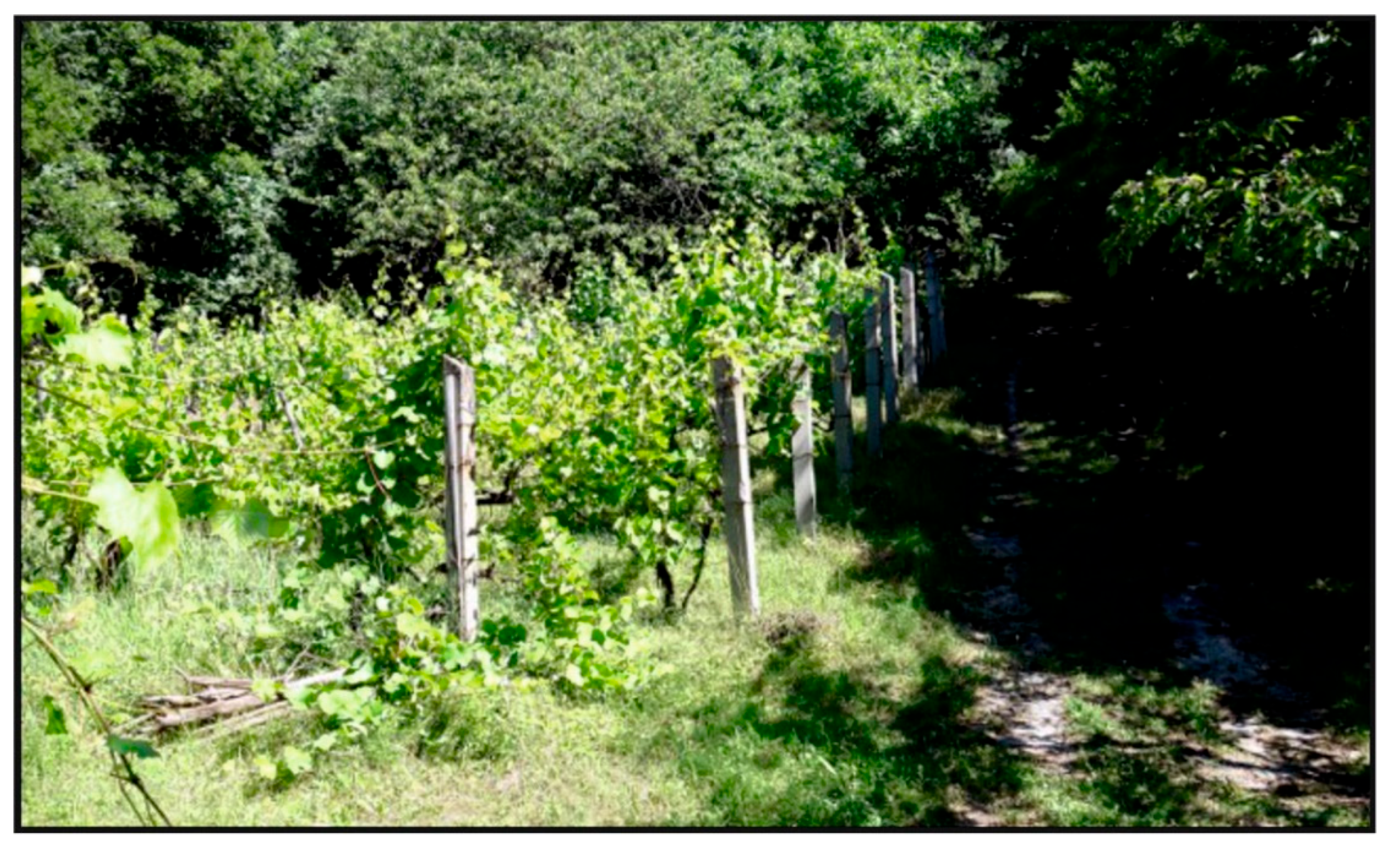
In the first time horizon (1783), the vineyards were spread on the sunny slopes of the Visegrád Mts. (Map 1 in Figure 9). The large area of the LUC (122.7 ha) indicates that the village type of viticulture was intensively developing in Mlynky in the last quarter of the 18th century. During the 19th century, the areas of vineyards with solitary fruit trees with quince and chestnut in the sites of Švábské vinohradi (Trniny) and Kopanica significantly decreased: 20.1 ha in 1841, or less than 35 ha in 1886 (Maps 2 and 3 in Figure 9). According to [5], grape phylloxera (Viteus vitifoliae) destroyed most of the vineyards. Vineyards were last included in the landscape structure of the studied area in 1941; at the Kopanica site, they were mapped on an area of 8.1 ha (Map 4 in Figure 9). From the 1960s to the present (2022), parts of the affected land became part of the village urban area with houses and gardens or were covered by succession. Small areas have been preserved only at the site Ge stuďjénke (Kopanica) (Figure 11). The development of vineyard areas is shown in Table 2 and Scheme 1.
Except for the first period (1783), the areas of permanent crops were relatively small, which did not significantly influence the low values of the Cai coefficient in subsequent time horizons (Table 3).
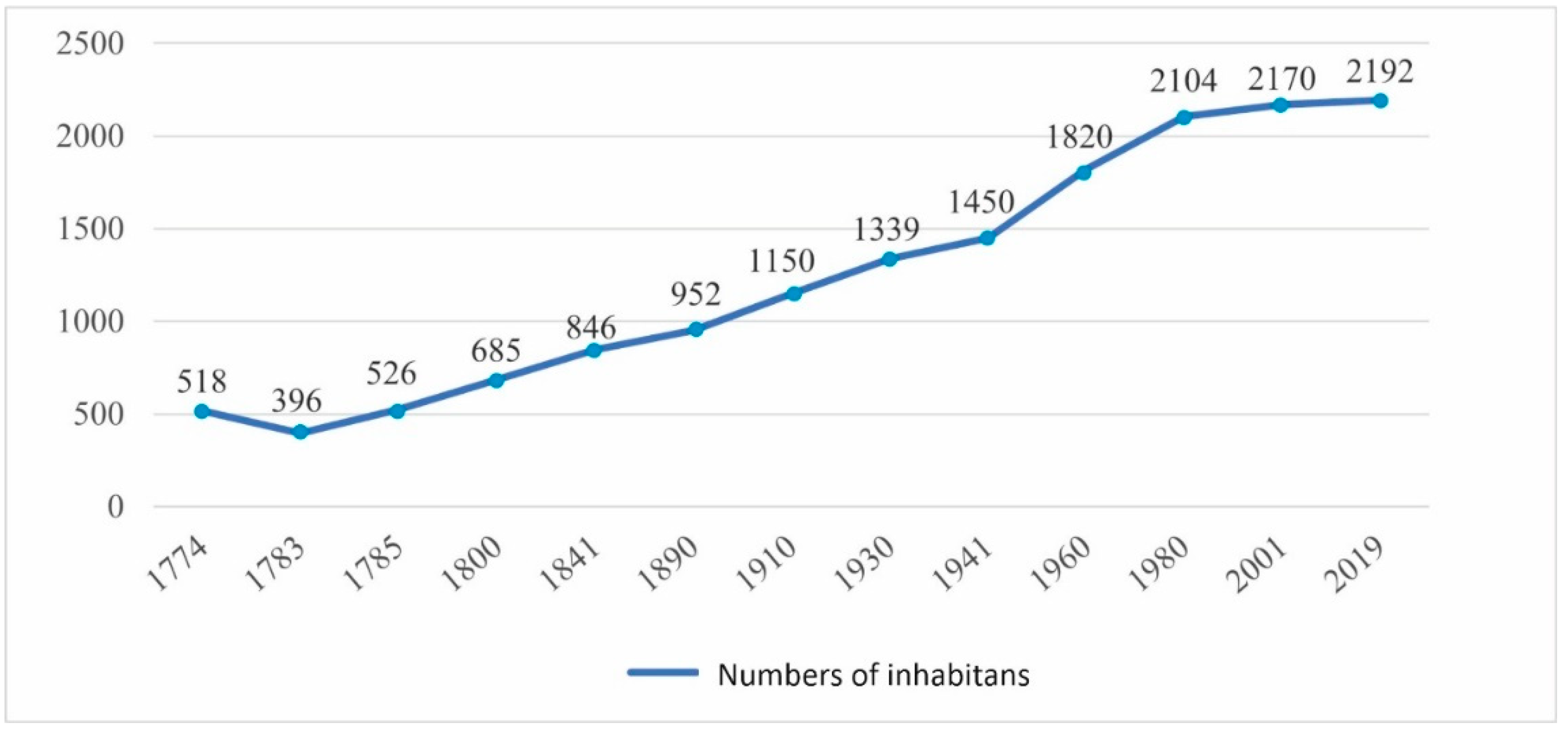
Built-up area. The area of the LUC during individual periods corresponded to the development of the population of Mlynky (Scheme 1 and Scheme 2). In 1783, the built-up area covered 8.1 ha. From a morphogenetic aspect, the village of Szt. Kerest, which had been settled by a larger group of Germans two years earlier [5], developed as a road village. The central urbanization axis of the rural settlement was formed by the Hlavná Street (Map 1 in Figure 9). Despite the high infant mortality rate, the local community population was characterized by a high natural increase. That is why in the following period, the area of residential development increased by more than 100% to 16.4 ha (Map 2 in Figure 9). At the same time, another urbanization axis was created along Pomázská and Chotárná Streets. In 1886, a minor decrease in the area of Mlynky (13.6 ha) can be observed, which is potentially related to the fire in 1867 [5].
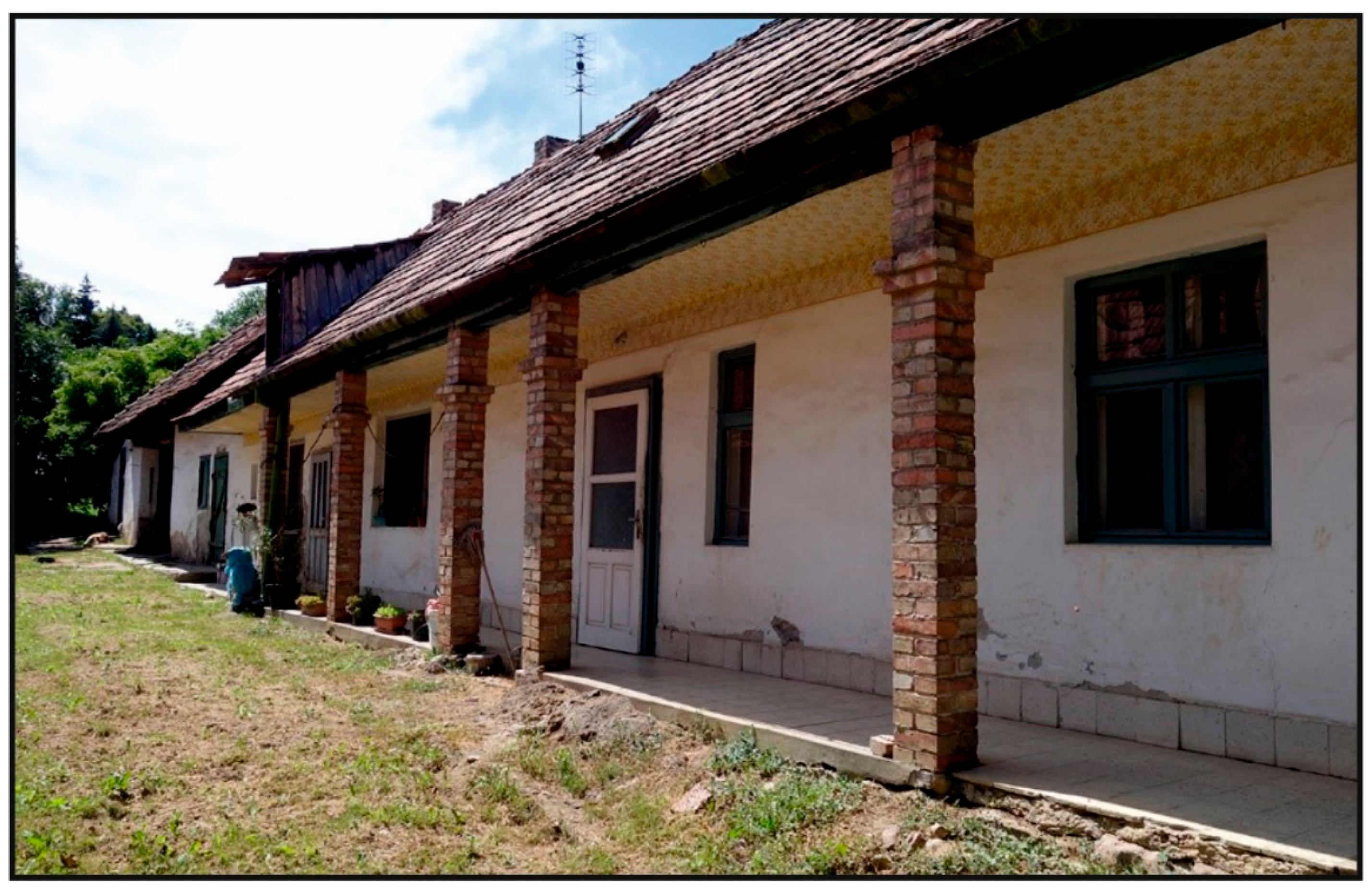
The economic effect of lime burning, charcoal production, and timber harvesting [30], as well as the alternating system of farming on arable land, was manifested in the first half of the 20th century, among other things, by an increased rate of natural increase, which increased the number of inhabitants of the village (Scheme 2). The factors led to a nearly doubled built-up area, reaching 23.1 ha by 1941. New construction affected areas of arable land, permanent grasslands, and unproductive vineyards destroyed by the phylloxera crisis. An interesting feature of Mlynky from this period is the common yards oriented perpendicular to the street (mostly on Hlavná Street), created by the gradual addition of dwellings in depth (Figure 12). Companions (společníci), members of the original extended family, inhabited individual houses. The poverty of the villagers prompted the specific housing solution.
Map 4 in Figure 9 shows the recreational area with tourist shelters and cottages on the permanent grassland areas in the Chotárna skala area, which were built here from the end of the 19th century. The Budapest branch of the Hungarian Tourist Association initiated the construction of recreational facilities (hotels and cottages).
In the 1960s, the residential development area reached 48.2 (2.8%). New buildings, renovated buildings, and hotels in the Dobogóš/Chotárna skala area represented part of this area. In 2022, the area of the studied LUC was 124.9 ha (7.3% of the studied area). Development areas for a new housing project in Mlynky utilized primarily the sloped terrain of the Visegrád Mts., which consists of former vineyards, meadows, and pastures. The construction of gardens or plots of arable land also resulted in the densification of the existing architecture in the basin part of the urban area. At the beginning of the new millennium, the village was developing as a quasi-compact settlement with two main urbanization lines. From a morphogenetic point of view, it was a road village. At the same time, the arrangement and orientation of the streets respected the specifics of the georelief of the local landscape, which lies at the contact of the Visegrád Mts. and the basin.

5. Discussion

Small areas of LUC with a high level of anthropogenic use (arable land and permanent crops) point to the importance of natural driving forces [57], which played a fundamental role in cultivating the municipality of Mlynky’s landscape during the monitored periods.
The dynamics of the forest, woodland, and shrub areas from 1783 to 2022 illustrate the synergistic effects of sustainable management on the slopes of the Pilis and Visegrád Mountains. Inhabitants left the mountain slopes with a high inclination forested and used them for logging. At the foot of specific mountain ranges, scattered settlements with fields and vineyards (Visegrád Mts.) were created during the second half of the 18th century. The erosion of arable land and the phylloxera crisis accelerated the gradual reforestation of selected fields and vineyards in the mountainous landscape during the 19th and 20th centuries. The overall development of the LUC in the studied area is characterized by a permanent growth of its area (including an extreme increase after the declaration of the Danube–Ipoly NP in 1997), which was accompanied by the introduction of acacia and various conifers on the slopes of the Mlynky mountain ridge and in the basin.
Such a development of the forest and woodland and shrubs corresponds to Mather’s theory of “forest transition” [69], and we have also recorded it in other studied areas, or Slovak enclaves in Hungary, e.g., Čív [70], Senváclav [71], and Tardoš [25]. All three mentioned Slovak enclaves, together with Mlynky, were established or colonized by the Slovak ethnic group approximately at the same time. The natural conditions in the studied enclaves are also similar; all of them are located in the foothills or mountainous (Senváclav) landscape of the Pilis Mountains and the Visegrad Mountains, which is formed by the same geological substrate (carbonates, in the case of Mlynky carbonates, and volcanics, Senváclav volcanics). For comparison, the area of forests in the Čív enclave was only 28.5% in 1782–1785; in 2019, it increased to 41.5% [70]. In Senváclav, the area of forests in 1780 was up to 64% (the highest within the Slovak enclaves), and in 2009, it even increased to 79% [71]. A slightly different development of forests was observed in the Tardoš enclave. In this case, however, part of the forests was converted into permanent grassland, i.e., a category of the land cover class that does not represent arable land [25]. On the contrary, we observed a significant decrease in the case of arable land in all enclaves. In the years 1782–1785, arable land in the Čív enclave accounted for 56.7% and, in 2017, only 29% [70]. In 1780, the area of arable land in Senváclav was 32.2%, but in 2009, only 0.7% [71]. In the years 1782–1785, the area of arable land in Tardoš was 44.1% and, in 2017, only 31.2% [25].
According to A. Mather [69], the long-term decline in forest stands was replaced by a gradual increase in their area in the 19th century. This process is characteristic of peripheral areas or regions with less favorable natural conditions.
The location and extent of intensive LUCs (arable land, permanent crops, and residential development) from 1783 to 2022 resulted from the interaction of natural and social driving forces. In the mid-18th century, the population of Slovak origin (and probably a few Moravians) began to cultivate wasteland near the ruins of a medieval monastery. The subjects of the settlers’ land rent were the products of plant and animal production, cash benefits from land use, and work obligations in favor of the landowner. Unfavorable natural conditions limited the efficiency of agricultural production in the studied area. The effect of these influences is reflected in the decreasing area of arable land. An alternative to the main occupation for a part of the domestic population was working in the forest, producing lime and charcoal, and selling these commodities. These facts and the natural population growth supported the expansion of residential development areas within the built-up area in the 19th century.
A stable cultural landscape as a heritage has become an increasingly sought-after environment for tourism in this geographical area. At the turn of the 19th and 20th centuries, a recreational area with tourist shelters and cottages (later with hotels) was created on the permanent grasslands at the Chotárna skala/Dobogóš site. The trend of increasing the area of the given LUC in the studied area accelerated during the socialist period and persisted until the end of the 1990s. There is minimal growth of residential development areas in the Mlynky area (including Chotárna skala), which reflects the economic aspect of extensive use and protection of the local landscape.
The methodology used and the results achieved can be applied in basic research when studying enclaves inhabited by ethnic Slovaks in Hungary and elsewhere. For example, findings on land use changes and their contexts can be saturated by social practice in creating integrated landscape management, which we present as framework proposals. Their goal is to harmonize the development of anthropogenic activities while preserving the cultural–historical potential and heritage of the studied area.
Proposal No. 1: Preservation of the ecological stability of the local landscape.
The values of the Cai and Cclo coefficients in Table 3 show that the landscape of the studied area has been stable, even highly stable, since the mid-20th century, with a low share of intensive LUC. Despite specific natural conditions (the inclination of mountain slopes, slightly arid climate, and erosion of arable land at the foot of the Pilis and Visegrád mountains), the first period (1783) is characterized by a balance of areas of intensive and extensive LUCs. Further land use development is characterized by mitigation (the 19th century to the first half of the 20th century) and marginal anthropic pressure on the landscape (the second half of the last century–2022). The increase in natural and semi-natural land use areas, primarily forests, woodlands, shrubs, fallows, arable land, and permanent grasslands, was the reason.
Preserving the ecological stability of the landscape will support the maintenance of biodiversity, especially in the basin part of the territory of Mlynky municipality. Plots used as agricultural land in the past were overgrown by succession. For this reason, it would be appropriate to restore the production function of the local landscape by revitalizing extensive cattle, sheep, or goat farming in combination with sustainable management on small areas of arable land, which can effectively compensate for the damage caused by the forest animals of the Donau–Ipoly NP.
Proposal No. 2: Ensuring the social and cultural diversity of the local landscape.
The cultural landscape of the studied area with LUC areas represents a complex product, the result of modern colonization by (primarily) Slovak ethnic groups. Parts of the tangible cultural heritage of Pilišans (i.e., Slovaks from Mlynky) are areas of various types of organically developed historical cultural landscapes (for more details, see [72]) or landscape archetypes. Their identification and subsequent protection, revitalization, or sustainable use can support the social and cultural diversity of the local landscape (and indirectly also the identity of members of the Slovak ethnic group in the municipality).
The remnant of the historical cultural landscape of lime production workshops (or the archetype of the rural pre-industrial landscape) has been preserved in the extravillain of Mlynky at the mouth of the Szurdokvölgy valley. It is a relic of a production area with a wall quarry and a lime kiln. In the forested part of the mountainous landscape of the studied area, areas of young oak and oak–hornbeam forests with an admixture of beech, created by human economic activity, have been preserved. They contain specific relics of the historical forest landscape—pasture forests, which were still used for grazing cattle and goats in the first half of the 20th century.
The archetype of the vineyard landscape at the Ge Stuďjénke or Kopanica sites currently performs mainly a landscape-forming function. Despite the advanced succession stage of small-scale vineyards, fruit trees and stone fences (piles of stones) on the borders of the plots complete the identity of the local landscape. Ensuring the diversity of the abovementioned types (archetypes) of historical landscapes in the Mlynkov non-urban area is currently limited by the nature protection of the Danube–Ipoly NP. Therefore, it is necessary to consider modifying the existing landscape plan for the protected area.
In the built-up part of the urban area (Hlavná ulica), the archetype of the village core near the main road (road village) has been preserved. Its urban and architectural significance is highlighted by the common courtyards with the houses of the companions and the church. In the case of common courtyards, we propose to emphasize their monumental value and specify this fact in the Mlynky spatial plan.

6. Conclusions

The purpose of this paper was to characterize the territory of the municipality of Mlynky from a cultural–ecological as well as geo-ecological point of view and to reconstruct the use of the local landscape areas (historical land use) with an emphasis on the period from the mid-18th century to 2022 in order to harmonize the development of anthropogenic activities while preserving the cultural–historical potential of the studied area and selected landscape archetypes.
The topic and its contexts reflect an integrated view of the natural conditions of the area, historical events, and the use of the local landscape in the past. Effective use of the results of such research (and their possible application in social practice) can be achieved, for example, through experiential education in the form of a lectured excursion, a study of the local landscape on old maps, or a virtual tour of specific locations online. The Minority Slovak Self-Government can organize these (and other) activities in Mlynky in cooperation with the municipal leadership. Their goal should be to strengthen and develop the identity of the local population [73,74].
The research results also have the potential to address issues and problems of harmonization and revitalization of the natural and socioeconomic subsystems of the local landscape. The methodology and selected findings on the local landscape, the relationship between humans and the natural environment, or the development of historical land use in the studied region can be applied in basic research when studying other expatriate enclaves in Central Europe or overseas. The selected data or their contexts can also be effectively used in creating proposals and solving some problems of integrated cultural landscape management (e.g., preserving, revitalizing, and protecting selected landscape archetypes).

Author Contributions

Conceptualization, P.C. and B.H.G.; methodology, P.C.; software, B.H.G.; validation, P.H. and B.H.G.; formal analysis, B.H.G.; investigation, P.C.; resources, P.C.; data curation, P.H.; writing—original draft preparation, P.C.; writing—review and editing, B.H.G.; visualization, B.H.G.; supervision, P.H.; project administration, P.H.; funding acquisition, P.H. All authors have read and agreed to the published version of the manuscript.

Funding

This research was funded by the Scientific Grant Agency of the Ministry of Education, Research, Development, and Youth of the Slovak Republic and the Slovak Academy of Sciences, grant number VEGA 1/0770/24: “The disappeared landscape of Matej Bel (reconstruction and environmental history of the historical landscape in the 18th century)”.

Data Availability Statement

The raw data supporting the conclusions of this article will be made available by the authors on request.

Conflicts of Interest

The authors declare no conflicts of interest. The funders had no role in the design of this study; in the collection, analyses, or interpretation of the data; in the writing of this manuscript; or in the decision to publish the results.

References

  1. Frisnyák, S. Északi-közephegység. Visegrádi-hegység. In Magyarország Földrajza, 1st ed.; Frisnyák, S., Ed.; Tankönyvkiadó: Budapest, Hungary, 1988; pp. 247–249. [Google Scholar]
  2. Süli-Zakar, I. Dunántúli-közephegység. Dunazug-hegyvidék. In Magyarország Földrajza, 1st ed.; Frisnyák, S., Ed.; Tankönyvkiadó: Budapest, Hungary, 1988; pp. 238–243. [Google Scholar]
  3. Haas, J. Late Trassic platform, slope and basin deposits in the Pilis Moutains, Transdanubian Range, Hungary. Centr. Europ. Geol. 2010, 53, 233–259. [Google Scholar] [CrossRef]
  4. Haas, J. Geology. In National Atlas of Hungary—Natural Environment, 1st ed.; Kocsis, K., Ed.; MTA CSFK Geographical Institute: Budapest, Hungary, 2018; pp. 42–57. [Google Scholar]
  5. Papuček, G.M. Mlynky a okolie, I. Diel, 1st ed.; Samospráva obce Mlynky: Mlynky, Romania, 2000; p. 334. [Google Scholar]
  6. Tarábek, K. Klimatickogeografické typy. Mierka 1:1,000,000. In Atlas Slovenskej Socialistickej Republiky, 1st ed.; Mazúr, E., Ed.; SAV. Slovenský Úrad Geodézie a Kartografie: Bratislava, Slovakia, 1980; p. 64. [Google Scholar]
  7. Bihari, Z. Climate. In National Atlas of Hungary—Natural Environment, 1st ed.; Kocsis, K., Ed.; MTA CSFK Geographical Institute: Budapest, Hungary, 2018; pp. 58–69. [Google Scholar]
  8. Káróssy, C. Magyarország éghajlata. In Magyarország Földrajza, 1st ed.; Frisnyák, S., Ed.; Tankönyvkiadó: Budapest, Hungary, 1988; pp. 50–77. [Google Scholar]
  9. Petrovič, Š. Klimatické pomery na Slovensku. In Slovensko 2 Príroda, 1st ed.; Lukniš, M., Ed.; Obzor: Bratislava, Slovakia, 1972; pp. 211–274. [Google Scholar]
  10. Šimo, E.; Zaťko, M. Typy režimu odtoku. Mierka 1:1,000,000. In Atlas Slovenskej Socialistickej Republiky, 1st ed.; Mazúr, E., Ed.; SAV. Slovenský Úrad Geodézie a Kartografie: Bratislava, Slovakia, 1980; p. 65. [Google Scholar]
  11. Zaťko, M. Podpovrchové vody. In Slovensko 2 Príroda, 1st ed.; Lukniš, M., Ed.; Obzor: Bratislava, Slovakia, 1972; pp. 342–360. [Google Scholar]
  12. Pásztor, L. Soils. In National Atlas of Hungary—Natural Environment, 1st ed.; Kocsis, K., Ed.; MTA CSFK Geographical Institute: Budapest, Hungary, 2018; pp. 82–93. [Google Scholar]
  13. Mičian, Ľ. Pedogeografie. In Fyzická Geografie, 1st ed.; Horník, S., Ed.; SPN: Praha, Czechia, 1986; pp. 109–196. [Google Scholar]
  14. Šály, R.; Šurina, B. Pôdy. Scale 1:500,000. In Atlas krajiny Slovenskej Republiky, 1st ed.; Miklós, L., Ed.; MŽP SR: Bratislava, Slovakia, 2002; pp. 106–107. [Google Scholar]
  15. Krištofičová, E. Prostriedky Hodnotenia Knižničných a Vedeckoinformačných Procesov, 1st ed.; CVTI: Bratislava, Slovakia, 1997; p. 157. [Google Scholar]
  16. Carrizo-Sainero, G. Toward a concept of bibliometrics. J. Span. Res. Inf. Sci. 2000, 1, 1–6. [Google Scholar]
  17. Ondrišová, M. Bibliometria, 1st ed.; STIMUL: Bratislava, Slovakia, 2011; p. 134. [Google Scholar]
  18. Fescenko, A.; Nikodemus, O.; Brūmelis, G. Past and Contemporary Changes in Forest Cover and Forest Continuity in Relation to Solis (Suthern Latvia). Pol. J. Ecol. 2014, 62, 625–638. [Google Scholar]
  19. Boltižiar, M.; Chrastina, P.; Trojan, J. Vývoj využívania kultúrnej krajiny slovenskej enklávy Šára v Maďarsku (1696–2011). Geogr. Inf. 2016, 20, 24–37. [Google Scholar]
  20. Chrastina, P. Krajina Veľkého Bánhedeša a jej premeny. In Acta Nitriensiae 10, 1st ed.; Gadušová, Z., Ed.; FF UKF: Nitra, Slovakia, 2008; pp. 74–94. [Google Scholar]
  21. Chrastina, P. Pivnica: Krajina—Človek—Kultúra slovenskej enklávy v srbskej Báčke. In Svedectvá Slovenského Dolnozemského bytia: Aspekty zo Slovenskej Dolnozemskej Kultúrnej Histórie a Kultúrnej Antropológie, 1st ed.; Ambruš, I.M., Ed.; Vydavateľstvo I. Krasko: Nadlak, Romania, 2012; pp. 187–201. [Google Scholar]
  22. Chrastina, P. Zmeny využívania krajiny Békešskej Čaby. In Kapitoly z Minulosti a Súčasnosti Slovákov v Békešskej Čabe, 1st ed.; Kmeť, M., Tušková, T., Uhrinová, A., Eds.; Magyarországi Szlovákok Kutatóintézete: Békešská Čaba, Hungary, 2018; pp. 378–401. [Google Scholar]
  23. Chrastina, P.; Boltižiar, M. Butín: Krajina—Človek—Kultúra slovenskej enklávy v rumunskom Banáte. Studia Hist. Nitriensia 2008, 14, 165–193. [Google Scholar]
  24. Chrastina, P.; Boltižiar, M. Senváclav: Krajina—Človek—Kultúra slovenskej enklávy vo Vyšegrádskych vrchoch. Studia Hist. Nitriensia 2010, 15, 53–86. [Google Scholar]
  25. Chrastina, P.; Trojan, J.; Župčán, L.; Tuska, T.; Hlásznik, P.P. Land use ako nástroj revitalizácie krajiny na príklade slovenskej exklávy Tardoš (Maďarsko). Geogr. Cassoviensis 2019, 13, 121–140. [Google Scholar]
  26. Chrastina, P.; Trojan, J.; Valášek, P. Historický “land use” Tardoša. In Slovenské Inšpirácie z Tardoša, 1st ed.; Tušková, T., Žiláková, M., Eds.; VÚSM: Békešská Čaba, Hungary, 2018; pp. 65–88. [Google Scholar]
  27. Chrastina, P.; Křováková, K.; Brůna, V. Zmeny krajiny v rumunskom Bihore (na príklade slovenskej enklávy Borumlak a Varzaľ). Hist. Geogr. 2007, 32, 371–398. [Google Scholar]
  28. Frisnyák, S. Magyarország tájai. In Magyarország földrajza, 1st ed.; Frisnyák, S., Ed.; Tankönyvkiadó: Budapest, Hungary, 1988; pp. 145–150. [Google Scholar]
  29. Šomšák, L. Flóra a Fauna v Rastlinných Spoločenstvách Strednej Európy (Aplikovaná biocenológia), 1st ed.; PríF UK: Bratislava, Slovakia, 1998; p. 308. [Google Scholar]
  30. Fügedi, E. Príspevky k dejinám osídlenia niektorých slovenských obcí na území dnešného Maďarska: Mlynky (Pilisszentkereszt). In Atlas slovenských Nárečí v Maďarsku, 1st ed.; Király, P., Ed.; VÚSM: Budapest, Hungary, 1993; pp. 79–80. [Google Scholar]
  31. Krupa, O. Charakteristika skúmaných lokalít: Mlynky. In A Magyarországi Szlovákok Népi kultúrájának Atlasza (A Mai Ismertek és Gyakorlat Alapján), 1st ed.; Divičanová, A., Ed.; Békéscsaba: Békešská Čaba, Hungary, 1996; p. 86. [Google Scholar]
  32. Szabová Marloková, J. Z minulosti obce Mlynky (v zrkadle novších výskumov). In Národopis Slovákov v Maďarsku, 1st ed.; Divičanová, A., Ando, J., Eds.; Magyar Néprajzi Társaság: Budapešť, Hungary, 2001; pp. 103–107. [Google Scholar]
  33. Sirácky, J. Slovenské osídlenie Dolnej zeme a jeho vývin do konca prvej svetovej vojny: Vznik a vývin slovenského osídľovania na území dnešného Maďarska. In Slováci vo Svete, 1st ed.; Sirácky, J., Botík, J., Bartalská, Ľ., Eds.; Matica slovenská: Martin, Slovakia, 1980; pp. 36–63. [Google Scholar]
  34. Sirácky, J. Sťahovanie Slovákov na Dolnú zem v 18. a 19. Storočí, 1st ed.; Matica slovenská: Martin, Slovakia, 1971; p. 293. [Google Scholar]
  35. Pető, Z.E. Roman or medieval? Historical roads in the Pilis forest. Hungar. Archaeol. 2014, 3, 1–9. [Google Scholar]
  36. Békefi, R.A. Pilisi apatság története 1184–1541, 1st ed.; F. Pfeifer: Pécsett, Hungary, 1891; p. 527. [Google Scholar]
  37. Pető, Z.E. The Medieval Landscape of the Pauline Monasteries in the Pilis Forest. Master’s Thesis, Central European University, Vienna, Austria, 2014. [Google Scholar]
  38. Vida, B. Foundation process of the Order of cistercians in Hungary. Kultúr. Dejiny 2015, 6, 3–31. [Google Scholar]
  39. Szabó, P. Woodland and Forests in Medieval Hungary, 1st ed.; Oxford: Archaeopress, UK, 2005; p. 187. [Google Scholar]
  40. Demek, J. Úvod do Štúdia Teoretickej Geografie, 1st ed.; SPN: Bratislava, Slovakia, 1987; p. 241. [Google Scholar]
  41. Ivanička, K. Základy Teórie a Metodológie Socioekonomickej Geografie, 1st ed.; SPN: Bratislava, Slovakia, 1983; p. 432. [Google Scholar]
  42. Butlin, R.A.; Dodgshon, R.A. An Historical Geography of Europe, 1st ed.; Claredon Press: Oxford, UK, 1998; p. 373. [Google Scholar]
  43. Chrastina, P. Krajina ako jeden zo styčných fenoménov prírodných a spoločenských vied. Acta Hist. Nitriensia 2001, 4, 333–344. [Google Scholar]
  44. Chrastina, P. Vývoj Využívania Krajiny Trenčianskej Kotliny a jej Horskej Obruby; UKF: Nitra, Slovakia, 2009; p. 285. [Google Scholar]
  45. Rábik, V.; Labanc, P.; Tibenský, M. Historická Geografia; Filozofická Fakulta Trnavskej Univerzity v Trnave: Trnava, Slovakia, 2013; p. 82. [Google Scholar]
  46. Semotanová, E. Historická Geografie Českých Zemí, 1st ed.; Historický Ústav AV ČR: Praha, Czechia, 2002; p. 279. [Google Scholar]
  47. Timár, G.; Lévai, P.; Molnár, G.; Varga, J. A második világháború német katonai térképeinek koordinátarendszere. Geodézia És Kartográfia 2004, 56, 25–35. [Google Scholar]
  48. Timár, G.; Molnár, G.; Székely, B.; Biszak, S.; Varga, J.; Jankó, A. Digitized Maps of the Habsburg Empire—The Map Sheets of the Second Military Survey and Their Georeferenced Version, 1st ed.; Arcanum: Budapest, Hungary, 2006; p. 59. [Google Scholar]
  49. Timár, G.; Biszak, S. Digitizing and georeferencing of the historical cadastral maps (1856–60) of Hungary. In Proceedings of the 5th International Workshop on Digital Approaches in Cartographic Heritage, Vienna, Austria, 22–24 February 2010, 1st ed.; Livieratos, E., Gartner, G., Eds.; Vienna University of Technology: Vienna, Austria, 2010; pp. 559–564. [Google Scholar]
  50. Solár, J.; Solár, V. Land-cover change in the Tatra Mountains, with a particular focus on vegetation. Eco.Mont. J. Prot. Mt. Areas Res. Manag. 2020, 12, 15–26. [Google Scholar] [CrossRef]
  51. Solár, V. Faktory a podmienky determinujúce zmeny krajinnej štruktúry Popradskej kotliny za ostatných 250 rokov. Geogr. Cassoviensis 2011, 5, 89–92. [Google Scholar]
  52. Acot, P. Historie a Změny Klimatu. Od Velkého Třesku ke Klimatickým Katastrofám, 1st ed.; Nakladatelství Karolinum: Praha, Czechia, 2002; p. 237. [Google Scholar]
  53. Balla, A. Mappa Plagae Inter Possessionem Cameralem Szántó et P. P. Paulinorum Szent Kereszt Controversae. Scale 1: 7200. S. l.:s. n. 1771. Sign. S_11_-_No._29/1-2. Available online: https://maps.hungaricana.hu/en/MOLTerkeptar/1419/view/ (accessed on 14 March 2024).
  54. Palkovič, K. Zo slovenských Pilišských nárečí v Peštianskej župe. In Slováci v Zahraničí, 1st ed.; Bulík, F., Baláž, C., Eds.; Matica Slovenská: Martin, Slovakia, 1985; Volume 11, pp. 109–134. [Google Scholar]
  55. Zichy, N. Mappa in processu ob demolitas metas. Scale 1:7200. S. l.:s. n. 1750. Sign. S_11_-_No._29/3. Available online: https://maps.hungaricana.hu/en/MOLTerkeptar/1420/?list/ (accessed on 23 June 2024).
  56. Urbarium of 1767. Pilisszentkereszt (Pest—Pilis—Solt). Available online: https://archives.hungaricana.hu/en/urberi/pest-pilis-solt-pilisszentkereszt/ (accessed on 2 September 2024).
  57. Bičík, I.; Jeleček, L.; Kabrda, J.; Kupková, L.; Lipský, Z.; Mareš, P.; Šefrna, L.; Winklerová, J. Vývoj Využití ploch v Česku, 1st ed.; Geographica: Praha, Czechia, 2010; p. 251. [Google Scholar]
  58. Míchal, I. Principy krajinářského hodnocení území. Archit. A Urban. 1982, XVI/Z, 65–87. [Google Scholar]
  59. Löw, J. Zásady pro Vymezování a Navrhovaní Územních Systému Ekologické Stability v Územne-Plánovací Praxi, 1st ed.; Brno: Agroprojekt, Czechia, 1984; p. 55. [Google Scholar]
  60. Miklós, L. Stabilita krajiny v ekologickom genereli SSR. Životné prostredie 1986, 20, 87–93. [Google Scholar]
  61. Kotrla, M.; Prčík, M. Ecological stability as a determinant of Nitra region development in Slovakia. Manag. Econ. Eng. Agric. Rural. Dev. 2014, 14, 165–170. [Google Scholar]
  62. Reháčková, T.; Pauditšová, E. Metodický postup stanovenia koeficientu ekologickej stability krajiny. Acta Environ. Univ. Comen. 2007, 15, 26–38. [Google Scholar]
  63. Labuda, M.; Pavličková, K. Zmeny vo využívaní poľnohospodárskej krajiny a jej ekologickej stability v rokoch 1955 a 1990 na území Myjavskej pahorkatiny. Acta Environ. Univ. Comen. 2006, 14, 65–75. [Google Scholar]
  64. Kupková, L. Data o krajině včera a dnes. 160 let v tváři české kulturní krajiny. GEOInfo 2001, 7, 16–19. [Google Scholar]
  65. Žigrai, F. Interpretácia historických máp pre štúdium využitia zeme a krajinnoekologický výskum. In Historické Mapy, 1st ed.; Kováčová, M., Hájek, M., Eds.; Kartografická Spoločnosť: Bratislava, Slovakia, 2001; pp. 35–40. [Google Scholar]
  66. Žigrai, F. Forming of the cultural landscape of Liptov in the past and today. Acta Geograph. Univ. Comen. 1971, 10, 137–155. [Google Scholar]
  67. Chrastina, P.; Hronček, P.; Gregorová, B.; Žoncová, M. Land-use changes of historical rural landscape—Heritage, protection and sustainable ecotourism: Case study of Slovak exclave Čív (Piliscsév) in Komárom-Esztergom County (Hungary). Sustainability 2020, 12, 6048. [Google Scholar] [CrossRef]
  68. Pilisszentkereszt Népessége (1870-tól 2019-ig). Available online: http://nepesseg.com/pest/pilisszentkereszt (accessed on 12 October 2024).
  69. Mather, A. The reversal of land-use trends: The beginning of the reforestation of Europe. In Land Use/Land Cover Changes in the Period of Globalization: Proceedings of the IGU-LUCC International Conference, 1st ed.; Bičík, I., Ed.; Charles University in Prague: Praha, Czechia, 2002; pp. 23–30. [Google Scholar]
  70. Chrastina, P. Slovenská enkláva Čív v Komárňansko-Ostrihomskej župe (Maďarsko): Krajina—Človek—Kultúra a čas. In Slovenské Inšpirácie z Čívu, 1st ed.; Tušková, T., Rágyanszki, J., Eds.; VÚSM: Békešská Čaba, Hungary, 2020; Volume 36, pp. 70–109. [Google Scholar]
  71. Chrastina, P.; Boltižiar, M. Vývoj využívania krajiny slovenskej enklávy Senváclav. In Slovenské Inšpirácie zo Senváclavu, 1st ed.; Tušková, T., Uhrinová, A., Eds.; VÚSM: Békešská Čaba, Hungary, 2019; Volume 31, pp. 13–38. [Google Scholar]
  72. Erlich, M.; Kuča, K.; Kučová, V.; Pacáková, B.; Pavlátová, M.; Salašová, A.; Šantrůčková, M.; Vorel, I.; Weber, M. Typologie Historické Kulturní Krajiny České Republiky, 1st ed.; Národní Památkový Ústav: České Budějovice, Czechia, 2020; 168p. [Google Scholar]
  73. Králik, R.; Lenovský, L.; Pavlíková, M. A few comments on identity and culture of one ethnic minority in central Europe. Europ. J. Scien. Theol. 2018, 14, 63–76. [Google Scholar]
  74. Lenovský, L. Identity as an instrument for interpreting the socio-cultural reality. Europ. J. Scien. Theol. 2015, 11, 171–184. [Google Scholar]
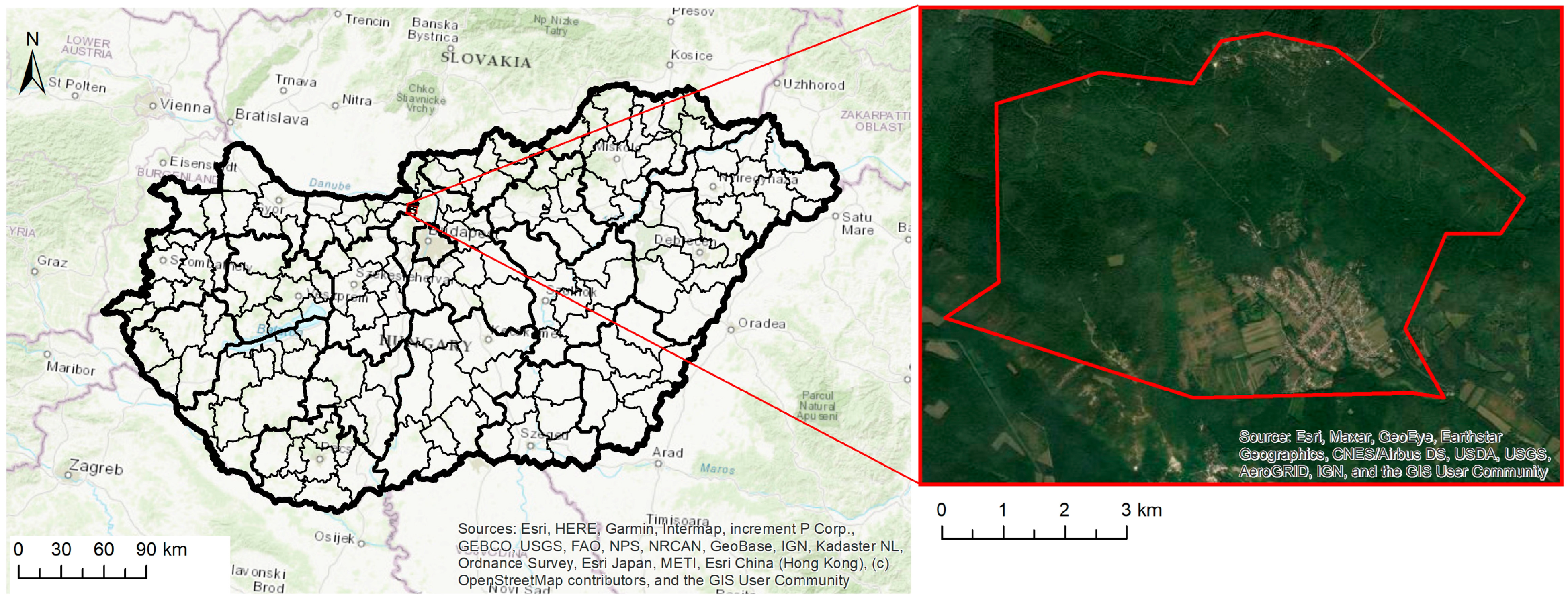
Figure 1. Location of the studied area. Author: B. Hrončeková Gregorová, 2025.
Urbansci 09 00357 g001
Figure 2. Pilis Mountain massif, view from the east (756 m a.s.l.). Author: P. Chrastina, 2022.
Urbansci 09 00357 g002
Figure 3. Visegrád Mountains and Mlynky Basin, view from the west. Author: P. Chrastina, 2022.
Urbansci 09 00357 g003
Figure 4. Schematic representation of theoretical and methodological research and work procedures. (Source: authors’ research).
Urbansci 09 00357 g004
Figure 5. The research area in historical maps in selected time horizons. (Source: http://mapire.eu/en/map/ (accessed on 28 May 2021); https://maps.arcanum.com/en/map/corona-hungary/ (accessed on 28 May 2021); Google Earth https://earth.google.com/web (accessed on 28 May 2021).
Urbansci 09 00357 g005
Figure 6. Kláštorná studienka (left) and Liesková studienka (right). Author: P. Chrastina, 2022.
Urbansci 09 00357 g006
Figure 7. The landscape of the village of Szent Kereszt is depicted on a map from 1750. Source: [55].
Urbansci 09 00357 g007
Figure 8. The landscape of the municipality of Szent Kereszt is depicted on a map from 1771. Source: [53].
Urbansci 09 00357 g008
Figure 9. Computer visualization of the historical land use of the studied area in selected time horizons. (Source: http://mapire.eu/en/map/ (accessed on 8 May 2025); https://maps.arcanum.com/en/map/corona-hungary/ (accessed on 8 May 2025); Google Earth https://earth.google.com/web (accessed on 8 May 2025).
Urbansci 09 00357 g009
Scheme 1. Development of land-use classes of the studied area from 1783 to 2022.
Urbansci 09 00357 sch001
Figure 10. Grasslands on luvisols (Odpotočné role). Author: P. Chrastina, 2022.
Urbansci 09 00357 g010
Figure 11. Abandoned vineyard at the site Ge stuďjénke (Hungarian: Kakas-h. szölők). Author: P. Chrastina, 2022.
Urbansci 09 00357 g011
Scheme 2. Development of the village of Mlynky population in the 18th to 21st centuries. Source: compiled by authors according to [5,68].
Urbansci 09 00357 sch002
Figure 12. The houses of companions (společníkov) in a typical yard. Author: P. Chrastina, 2022.
Urbansci 09 00357 g012
Table 1. Cartographic sources and their characteristics.
Cartographic SourceMap Sheet NumberScaleYear
I. Military mappingColl. XIII. Sectio XIII.
Coll. XIII. Sectio XIX.
1:28,8001783
II. Military mappingSection 48. Colonne XXXI.
Section 49. Colonne XXXI.
Section 49. Colonne XXXII.
1:28,8001841
Cadastral map 1:28801886
Topographic map of military mapping 1:75,0001941
Orthophoto map
(satellite image)
Approx. 1:75,0001960s
Orthophoto map
(satellite image)
Approx. 1:75,000(28 May 2021); update (19–24 June 2022)
Table 2. Land-use classes of the studied area from 1783 to 2022.
Land-Use
Classes (LUCs)
1783
Ha–%
1841
Ha–%
1886
Ha–%
1941
Ha–%
1960s
Ha–%
2022
Ha–%
Forests, woodland, and shrubs1134.6–66.21160.5–67.71185.0–69.31288.9–75.31293.9–75.61265.8–74.0
Permanent grasslands23.3–1.4241.7–14.1219.0–12.8128.4–7.573.4–4.344.8–2.6
Fallow lands on perman. grass.XXXXX53.9–3.2
Arable land413.9–24.2255.9–15.0230.5–13.5219.7–12.8209.6–12.33.2–0.2
Fallow lands on arable landXXXXX125.7–7.3
Gardens8.4–0.516.4–1.028.0–1.642.8–2.585.9–5.092.7–5.4
Vineyards122.7–7.220.1–1.234.9–2.08.1–0.5XX
Built-up area8.1–0.516.4–0.113.6–0.823.1–1.448.2–2.8124.9–7.3
1711.0–1001711.0–1001711.0–1001711.0–1001711.0–1001711.0–100
Table 3. Development of Cai and Cclo coefficients in 1783–2022.
Coefficient17831841188619411960s2022
Cai = H L 0.50.20.20.20.30.2
Cclo = f o r e s t + P G a r a b l e   l a n d 3.15.56.16.56.5409.6
Disclaimer/Publisher’s Note: The statements, opinions and data contained in all publications are solely those of the individual author(s) and contributor(s) and not of MDPI and/or the editor(s). MDPI and/or the editor(s) disclaim responsibility for any injury to people or property resulting from any ideas, methods, instructions or products referred to in the content.