Article

Subsiding Cities: A Case Study of Governance and Environmental Drivers in Semarang, Indonesia

by
Syarifah Aini Dalimunthe
1,
Budi Heru Santosa
2,*,
Gusti Ayu Ketut Surtiari
1,
Abdul Fikri Angga Reksa
3,
Ruki Ardiyanto
4,
Sepanie Putiamini
5,
Agustan Agustan
3,
Takeo Ito
6 and
Rachmadhi Purwana
7,*
1
Research Center for Population, The National Research and Innovation Agency, Jakarta 12710, Indonesia
2
Research Center for Limnology and Water Resources, The National Research and Innovation Agency, Bogor 16911, Indonesia
3
Research Center for Area Studies, The National Research and Innovation Agency, Jakarta 12710, Indonesia
4
Research Center for Minning Technology, The National Research and Innovation Agency, South Tangerang 15314, Indonesia
5
Directorate of Development Policy Environmental Maritime Affairs, Natural Resources and Nuclear Energy, The National Research and Innovation Agency, Jakarta 10340, Indonesia
6
Graduate School of Environmental Studies, Nagoya University, Nagoya 464-8601, Japan
7
School of Environmental Science, University of Indonesia, Jakarta 16424, Indonesia
*
Authors to whom correspondence should be addressed.
Urban Sci. 2025, 9(7), 266; https://doi.org/10.3390/urbansci9070266
Submission received: 24 April 2025 / Revised: 1 July 2025 / Accepted: 3 July 2025 / Published: 10 July 2025
(This article belongs to the Special Issue Sustainable Urbanization, Regional Planning and Development)

Abstract

Land subsidence significantly threatens vulnerable coastal environments. This study aims to explore how Semarang’s government, local communities, and researchers address land subsidence and its role in exacerbating flood risk, against the backdrop of ongoing efforts within flood risk governance. Employing an integrated mixed-methods approach, the research combined quantitative geospatial analysis (InSAR and land cover change detection) with qualitative socio-political and governance analysis (interviews, FGDs, field observations). Findings show high subsidence rates in Semarang. Line of sight displacement measurements revealed a continuous downward trend from late 2014 to mid-2023, with rates varying from −8.8 to −10.1 cm/year in Karangroto and Sembungharjo. Built-up areas concurrently expanded from 21,512 hectares in 2017 to 23,755 hectares in 2023, largely displacing cropland and tree cover. Groundwater extraction was identified as the dominant driver, alongside urbanization and geological factors. A critical disconnect emerged: community views focused on flooding, often overlooking subsidence’s fundamental role as an exacerbating factor. The study concluded that multi-level collaboration, improved risk communication, and sustainable land management are critical for enhancing urban coastal resilience against dual threats of subsidence and flooding. These insights offer guidance for similar rapidly developing coastal cities.

1. Introduction

Coastal cities worldwide are increasingly vulnerable to the combined pressures of climate change and groundwater over-extraction [1,2]. This vulnerability is worsened by rapid urban expansion toward coastal areas, leading to significant land subsidence—a gradual sinking of the ground’s surface. This process creates a cascade of severe urban problems, including chronic flooding, contaminated groundwater, and damaged infrastructure.
The compounded effects of these environmental and human factors jeopardize urban sustainability [3,4]. A lack of awareness from local governments often exacerbates these dangers, resulting in inadequate decision-making and ineffective mitigation efforts. This silent disaster is a critical threat to urban infrastructure, housing, and vulnerable low-income communities, leading to substantial economic losses, social instability, and increased inequality.
Land subsidence is driven by both natural and human factors. Natural processes like sediment compaction and tectonic activity contribute to vertical land movement. For coastal lowlands, this can expand flood-prone areas at rates that exceed sea-level rise, making them increasingly unsustainable. However, human activities, particularly the over-extraction of groundwater, are consistently identified in previous studies as a primary driver of land subsidence in urban areas. This slow-developing deformation is often only noticeable years later, making it a challenging issue to address.
Due to the threat of land subsidence, it has become a priority for international organizations, including the United Nations Educational, Scientific, and Cultural Organization (UNESCO), to monitor and address land subsidence since the 1960s [5]. Strategies for subsidence mitigation have been successfully implemented in cities such as Shanghai, China, and Kawajima, Japan, based on groundwater extraction control, continuous monitoring, and land-use zoning. However, many coastal cities, particularly in developing parts of the world, still experience significant subsidence-related challenges due to a lack of policy enforcement and weak institutional collaboration between relevant agencies [6,7,8,9].
One of the most striking examples of land subsidence-related urban challenges is Semarang, Central Java, Indonesia. The city experiences some of the fastest subsidence rates globally, with recorded sinking rates of up to 14 cm per year between 2017 and 2020 [10] and an average of 11 cm per year from 2014 to 2023 [11]. Semarang also features one of the city’s most prominent destinations, Old Town, which has European-themed architecture, so it attracts many foreign tourists. Nevertheless, this old town was frequently exposed to natural disasters, especially floods, due to the continuous land subsidence [11,12]. Subsidence wreaks havoc on local populations, often resulting in chronic flooding, deteriorating infrastructure, and socio-economic displacements. These issues have significant implications for the well-being of Semarang’s residents, impacting their livelihoods, health, and overall quality of life. For instance, the increased frequency and severity of flooding can spread waterborne diseases, damage homes and businesses, and disrupt essential services.
The subsidence crisis persists despite mitigation initiatives like the 100 Resilient Cities program and the Water as Leverage pilot project [13,14,15]. Land subsidence has caused IDR 3.5 trillion (USD 245 billion) in economic losses. However, subsidence risk has not been successfully incorporated into urban development and political will [16,17,18]. Furthermore, there is limited science-based support for policymakers to systematically enact integrated regulations and programs to reduce land subsidence risk. These problems call for a more holistic and sustainable strategy for urban resilience, encompassing improved infrastructure, effective water management techniques, and stricter land-use policies. Previous studies have focused more on the technological aspects of land subsidence issues in Semarang using remote sensing techniques like InSAR v2.3.3 [19,20,21].
In contrast, very few studies have dealt with the socio-political implications of mitigation efforts [22,23,24,25]. Most studies have omitted crucial issues of governance challenges, stakeholder engagement, and the long-term implementation effects of land subsidence management policies. Moreover, little research has explored how conflicting public narratives, risk normalization, and perceptions of responsibility interact with adaptation responses [26,27,28,29]. Furthermore, there is yet to be a complete understanding of the issue as a holistic concept.
Therefore, the study aims to explore how the government of Semarang, local communities, and researchers have developed innovative approaches to addressing land subsidence and to investigate the challenges and limitations they have encountered. The research questions the study aims to answer include the following:
  • What are the key significant determinants of subsidence in Semarang, and to what extent do urbanization, groundwater extraction, geology, or all these factors contribute the most?
  • How do governance frameworks, policy restrictions, and funding limitations affect the effectiveness of mitigation efforts?
  • How do public narratives, stakeholder engagement, and risk perception affect land subsidence adaptation strategies for land subsidence?
  • What implications can these findings have for better land subsidence management policies in urban coastal areas?
This study’s combination of governance analysis, stakeholder analysis, and interdisciplinary approaches can inform strategies for improving land subsidence mitigation. The results hope to serve as empirical evidence for land subsidence governance and help inform policies toward increasing the resilience of coastal cities. The remaining sections describe land subsidence, a review of urban coastal area governance, anthropogenic activities, environmental processes, and pertinent challenges, followed by future research directions. Focusing on Semarang, an Indonesian city with severe land subsidence, we analyze possible sustainable solutions that can be applied to other coastal cities with similar problems.

1.1. Understanding Land Subsidence

Land subsidence, a multidisciplinary geohazard, occurs due to natural and anthropogenic phenomena. Geologically, sedimentation and tectonic movements are significant causes. Sediment compaction refers to expelling pore water from sedimentary layers that reduce volume and sink the ground (for example, in deltas and coastal plains) [30,31,32]. Tectonic movements induce subsidence when the crust sinks after a gradual or sudden shift [33,34]. Understanding the scale of subsidence and mitigating its impacts requires monitoring. Geodetic methods, particularly interferometric synthetic aperture radar (InSAR), offer spatial and temporal observation data to monitor land deformation. This method, combined with ground-based measurements, provides enhanced subsidence monitoring.
Anthropogenic processes, especially over-extraction of groundwater, decrease hydraulic pressure in aquifers, leading to compaction and subsidence. High water-demand trajectories, typical of urbanized areas, are particularly susceptible [35,36]. Moreover, urbanization imposes an additional surface load, changes the soil drainage system, and decreases groundwater infiltration. For instance, in the Cangzhou Plain of China, sediment thickness and groundwater depletion are vital factors influencing subsidence rates [37,38]. Likewise, the treatments of mining and tunneling destroy the equilibrium of subsurface layers, causing the risk of subsidence to increase [39]. Although tectonic subsidence is gradual, anthropogenic subsidence is often fast-moving (in time and space) and can damage infrastructure. Long-term subsidence impacts must be mitigated through effective monitoring, management, sustainable practices on groundwater extraction, and urban planning [40,41,42].
Numerous global studies have highlighted land subsidence’s widespread and complex nature in rapidly urbanizing regions. Cities like Jakarta, Tehran, Mexico City, Beijing, and Ho Chi Minh City are experiencing severe subsidence driven mainly by excessive groundwater extraction and urban expansion [43,44]. These cities have reported significant ground deformation, affecting infrastructure stability, flood vulnerability, and urban safety. The persistence of this phenomenon reflects deeper issues in water governance, land use planning, and environmental management. Semarang’s current trajectory mirrors these global cases, emphasizing the critical need for early intervention, cross-sectoral policy alignment, and long-term monitoring to prevent irreversible damage.
Semarang City, Indonesia, illustrates the interaction between natural and anthropogenic subsidence processes. Built on young alluvial deposits, Semarang is naturally prone to compaction-driven subsidence. However, excessive groundwater extraction, responsible for as much as 82% of total subsidence in certain regions, has dramatically sped up this process [45]. Subsidence is also caused by (a) excessive groundwater extraction for agriculture and industrial purposes and (b) heavy loads due to industrialization, exacerbating subsidence in coastal and port areas with very high rates (19 cm/year). These impacts are rising flooding events, saltwater intrusion, and infrastructure damage, highlighting the immediate need for effective mitigation strategies [46].

1.2. Governance Structures and Policies Related to Land Subsidence

Particularly in deltaic areas like Semarang City, governance structures and policies are essential to manage the complex difficulties faced by sea-level rise (SLR) and land subsidence [47,48]. In Semarang, multi-level government-formulated adaptation programs typically use a non-binding, multi-sectoral approach that requires sectoral collaboration. Nevertheless, these efforts frequently depend on contributions from the voluntary sector to be implemented, and they have insufficient institutional frameworks for vertical and horizontal coordination [49]. This city serves as a reminder of how challenging it can be to coordinate adaptation measures across different governmental levels, especially in the lack of specialized climate change laws. Coastal management in Indonesia is overseen by a disorganized legal system comprising multiple authorities and legislation. Earlier studies [50,51,52] highlighted coastal management’s difficulties navigating the complexities of fourteen government agencies, twenty-two relevant acts, and hundreds of regulations. Effective implementation at the local level is hampered by this complicated governance system’s many gaps, ambiguities, redundancies, and conflicts. Nothing has changed, yet the difficulties associated with governance remain a significant obstacle to successful adaptation strategies.
The changes in authority required by regional Law No. 23/2014 exacerbate Semarang’s governance issues. This law changed how coastal regions are governed, giving provincial authorities control over management duties that district and municipal governments had previously held [53]. Local governments have less control over coastal management due to this law’s division of power between the federal and provincial governments over forestry, marine resources, and energy resources (Article 14(1)). Local governments used to oversee coastal areas up to four miles offshore, and provincial governments were in charge of the zone between four and twelve miles offshore. The new law raised the provincial government’s jurisdiction to include the 12-mile zone, raising questions about their involvement in municipal and regency-level attempts to manage the shoreline and adapt to changing conditions [54].
One of the key challenges arising from this governance shift is the legal and budgetary uncertainty faced by local governments in Semarang [28]. Although the areas designated for reforestation are now under provincial administration, these activities are essential for reducing the effects of SLR and ground subsidence. Therefore, local governments are unsure of their legal ability to fund these initiatives. Municipal governments have limited resources, making this scenario even more difficult. For example, the sub-district fund established by Law No. 6/2014 provides each sub-district with about USD 71,528 yearly from the national budget [55,56]. It is the only funding source available for adaptation at the sub-district level. Although this allocation supports local initiatives, it is not enough to enable comprehensive adaptation measures, especially when faced with significant environmental challenges.
A rising number of stakeholders are realizing the necessity of a hybrid governance model that encourages cooperation across various governmental levels in light of these budgetary and legal restrictions [47]. Under such a scenario, provincial governments could fund local adaptation programs by receiving grants from the national government. Furthermore, the establishment of task forces involving multiple governments may enable the participation of local authorities, communities, non-governmental organizations (NGOs), and private entities in the provision of nature-based solutions (NBSs), including the planting of mangroves and hybrid engineering initiatives [57,58]. This governance will encourage coordination and ensure adaptation measures are based on local knowledge and participation, thereby increasing the effectiveness [59].
The structure and policies of coastal management governance in Semarang are complex and diverse. The problems caused by land subsidence require a coordinated approach involving collaboration across levels of government and stakeholders. Effective policies with quantifiable targets and outcomes are essential to the success of these initiatives [60,61]. The concept of interactive governance, which emphasizes the integration of many governance levels in decision-making processes, must be reflected in such policies, which must be informed by local participation. Moreover, external stakeholders must be involved in program and financial performance monitoring and auditing to reduce project implementation risks.

1.3. Geological and Hydrological Setting

Land subsidence in Semarang is primarily the result of complex interactions between natural processes and geological factors operating at multiple spatial and temporal scales. Geologically, the city is underlain by unconsolidated alluvial sediments, including thick clay layers that are highly compressible and susceptible to moisture-induced shrink-swell behavior. These characteristics create a natural predisposition to vertical ground movement, particularly when influenced by environmental and hydrological cycles [62,63,64]. Natural processes such as seasonal rainfall variability, groundwater recharge and discharge dynamics, and the long-term compaction of sedimentary basins contribute to gradual surface deformation. Over time, these processes reduce the structural integrity of near-surface soils and amplify subsidence trends, especially in low-lying coastal and deltaic areas.
At a regional scale, crustal loading through sediment accumulation, combined with the natural compaction of marine and estuarine deposits, creates additional downward pressure. In Semarang, this subsidence is further exacerbated by intensive anthropogenic activity, especially groundwater extraction, which accelerates natural consolidation. The time-series InSAR analysis presented in this study reveals spatially variable subsidence patterns, with the highest rates observed in southeastern Semarang—an area geologically characterized by soft, water-saturated sediments and dense urban development.
The relationship between natural geological conditions and land subsidence is thus synergistic: inherent lithological vulnerability determines the sensitivity of the land surface to environmental change, while natural processes such as hydrological cycles, sediment loading, and chemical decomposition (e.g., organic soil decay) act as ongoing subsidence drivers. This interdependence underscores the importance of integrated geospatial monitoring and geotechnical assessments to manage risk in subsidence-prone urban regions.

2. Materials and Methods
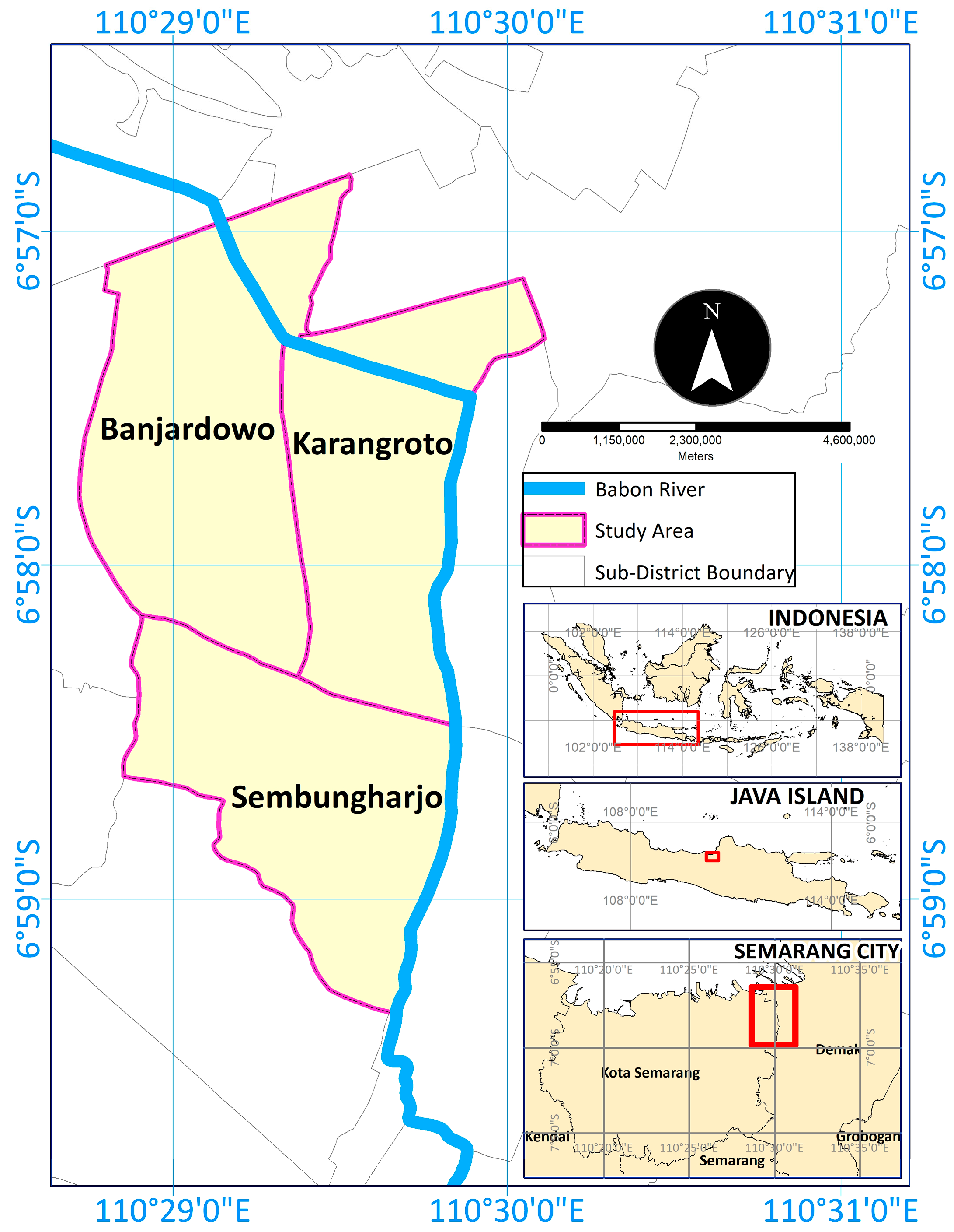
2.1. Study Area

This research was conducted in the Genuk District, located in the northeastern part of Semarang City on the coastal plain, characterized by a predominantly flat landscape with gradients of 0–2% (Figure 1). This low-lying characteristic renders the area particularly susceptible to inundation and tidal flooding. The district encounters considerable hydrological issues, with floodwaters frequently attaining depths of 0.5 to 1 m and persisting for 1 to 2 days. From 2020 to 2023, Genuk District had an annual population growth rate of 2.64%, significantly surpassing Semarang City’s average of 0.9%. As of 2023, the district’s total population was 126,799 individuals. This study focused on three sub-districts—Karangroto, Sembungharjo, and Banjardowo—selected based on three key criteria: high flood vulnerability, the presence of critical infrastructure, and confirmed subsidence rates derived from InSAR time-series analysis [11]. Although these areas represent only a portion of Semarang, they illustrate common patterns of physical hazards and governance issues across the city. This focused approach enables in-depth, context-sensitive analysis while providing findings applicable to broader urban subsidence dynamics. The sub-districts of Karangroto, Banjardowo, and Sembungharjo, with populations of 15,606, 11,365, and 14,962, respectively, comprised around 32.9% of the district’s total population [65,66].
Karangroto combines residential and industrial land use, making it susceptible to groundwater extraction and infrastructure stress. Sembungharjo is a densely populated residential area with low elevation and poor drainage, leading to frequent flooding (Figure 2). Banjardowo, closer to the coast, experiences riverine and tidal flooding, compounded by land subsidence. These sub-districts provide a microcosm of Semarang’s broader challenges, offering valuable insights into the interaction between subsidence, flooding, and urban governance.
The selection was based on three key criteria: high flood vulnerability, the presence of critical infrastructure (e.g., housing and transport), and confirmed subsidence rates derived from InSAR time-series analysis. Although these areas represent only a portion of Semarang, they illustrate common patterns of physical hazards and governance issues across the city. This focused approach enables in-depth, context-sensitive analysis while providing findings applicable to broader urban subsidence dynamics.

2.2. Methods

This study employs an integrated mixed-methods framework that combines qualitative socio-political analysis with quantitative geospatial analysis to provide a holistic and triangulated understanding of land subsidence challenges [67,68]. The two approaches were not conducted in parallel but were designed to be complementary and mutually informing. Quantitative spatial analysis provides empirical evidence of physical changes, while qualitative methods capture the lived experiences and governance dynamics associated with these changes. This integration is crucial for linking the biophysical process of subsidence with its human dimensions, which is a core objective of this research.

2.3. Qualitative Data Collection and Analysis

Data were collected through interviews, focus group discussions (FGDs), and field observations. All participants at both the government officials and community levels were anonymized while ensuring confidentiality. These were analyzed qualitatively to identify key themes related to flood management, infrastructure effectiveness, and the impact of land subsidence [69,70,71,72,73,74]. Triangulation of data sources ensured reliability and validity in the research outcomes [54]. Table 1 provides detailed information regarding the techniques used.
a. In-depth Interviews: We conducted semi-structured interviews with 12 key informants, including sub-district heads, local officials, disaster-resilient administrators, and the Mayor of Semarang. Participants were selected using purposive and snowball sampling to ensure a comprehensive understanding of sub-district-level decision-making. Interviews lasted 40–60 min and were audio-recorded with the informed consent of all participants. For data analysis, we used an inductive thematic analysis following the six-phase steps. This involved (1) familiarizing ourselves with the data by transcribing and re-reading the interviews, (2) generating initial codes, (3) searching for overarching themes, (4) reviewing and refining the themes, (5) defining and naming the themes, and (6) producing the final report. To ensure analytical rigor and reliability, two researchers independently coded a subset of the transcripts. An inter-coder reliability check was performed, with a Cohen’s Kappa score of >0.8, indicating strong agreement [75,76]. The final themes and findings were formally validated in a dedicated discussion session with academic and administrative experts, who provided critical feedback on the interpretation of the qualitative data.
b. Focus Group Discussions (FGDs): Three FGDs were conducted across the sub-districts of Karangroto, Sembungharjo, and Banjardowo to capture the diverse perspectives and collective experiences of local stakeholders [77,78,79]. Each FGD consisted of 8–12 participants, including community members, officials, and administrators, with a diverse mix of genders, ages (28–62 years old), and occupations. The semi-structured discussions explored themes such as the effectiveness of polder systems and community flood preparedness. Each session lasted 60–90 min and was audio-recorded with consent. The FGD transcripts were subjected to the same inductive thematic analysis process as the interview data. The findings were then triangulated with the interview data and field observation notes to identify convergent themes and discrepancies across different data sources. This triangulation process enhanced the validity and robustness of our qualitative findings by connecting lived experiences with different layers of information.
c. Field Observations: Systematic site visits were conducted in June 2023 to document the physical manifestations of land subsidence and the condition of flood management infrastructure. Researchers took extensive photographic and written notes on polder systems, drainage channels, and residential areas. These observations provided crucial empirical evidence that was used to contextualize and validate the qualitative data, linking reported challenges with observable realities on the ground [41].

Quantitative Geospatial Analysis

This section details the spatial analysis conducted by remote sensing researchers to provide empirical data on land subsidence and land cover changes. The resulting maps and data were used to spatially contextualize the qualitative findings, linking community perceptions to measurable physical processes.
a.
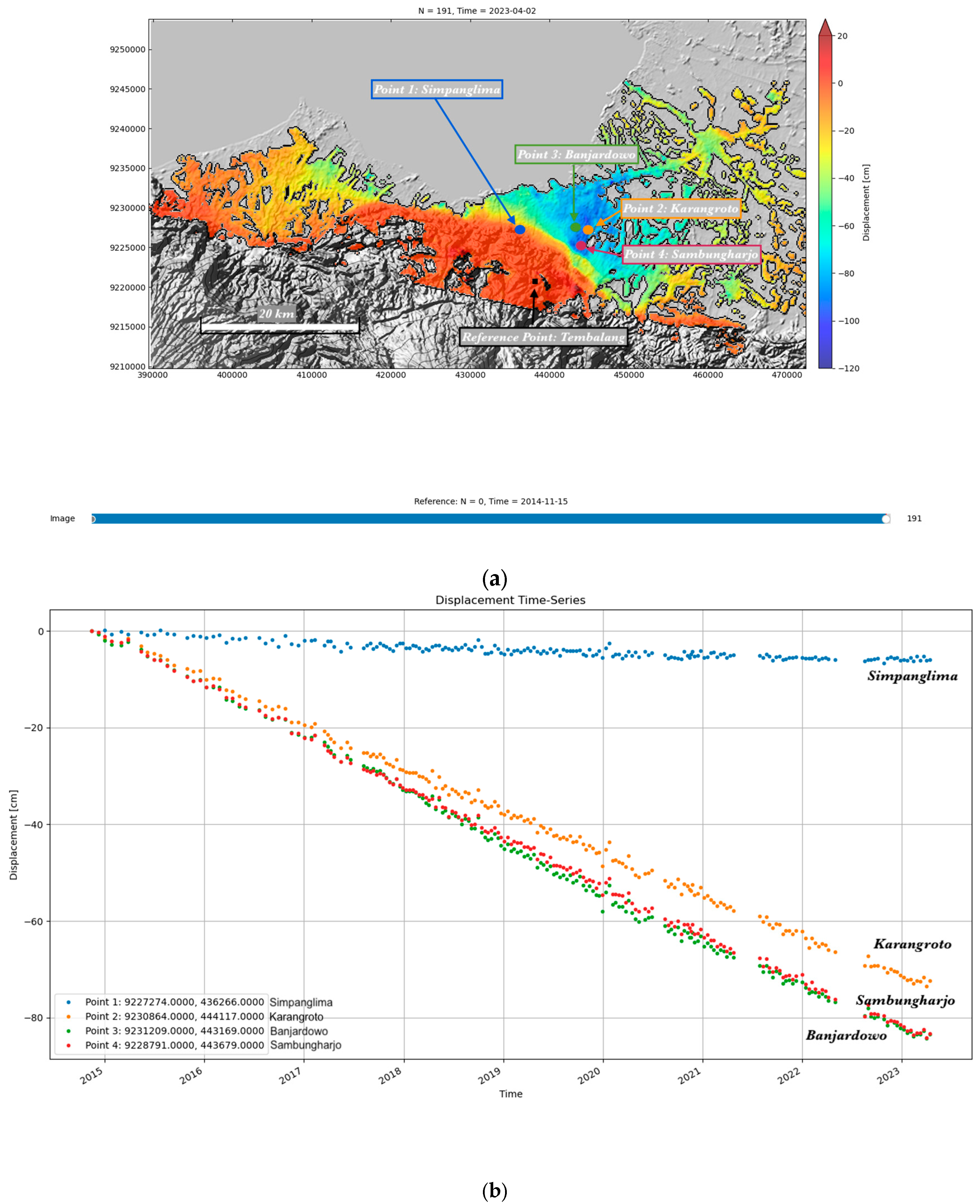
Land Subsidence Analysis using InSAR
The influence of land subsidence on the chosen sub-districts was evaluated through spatial analysis using time-series interferometric synthetic aperture radar (InSAR). The analysis utilized unwrapped phase data from Sentinel-1 imagery, processed on-demand via the HyP3 platform of the Alaska Satellite Facility (ASF), which provides standardized InSAR products for large-scale monitoring. Sentinel-1, operating in interferometric wide (IW) swath mode, has a native pixel spacing of approximately 5 m in range and 20 m in azimuth. For this study, which covers the period from 2014 to 2023, multi-looking was applied to the interferograms to reduce speckle noise and enhance phase coherence, especially in dense urban environments. This processing resulted in an effective spatial resolution of 80 × 80 m. The selected resolution represents a compromise between preserving spatial coverage and improving the signal-to-noise ratio, essential for reliably detecting long-term subsidence signals across the study area.
b.
Land Cover Change Analysis
We performed a quantitative analysis of land cover change to understand how urban development and other land use activities correlate with subsidence patterns. This analysis followed a three-step process:
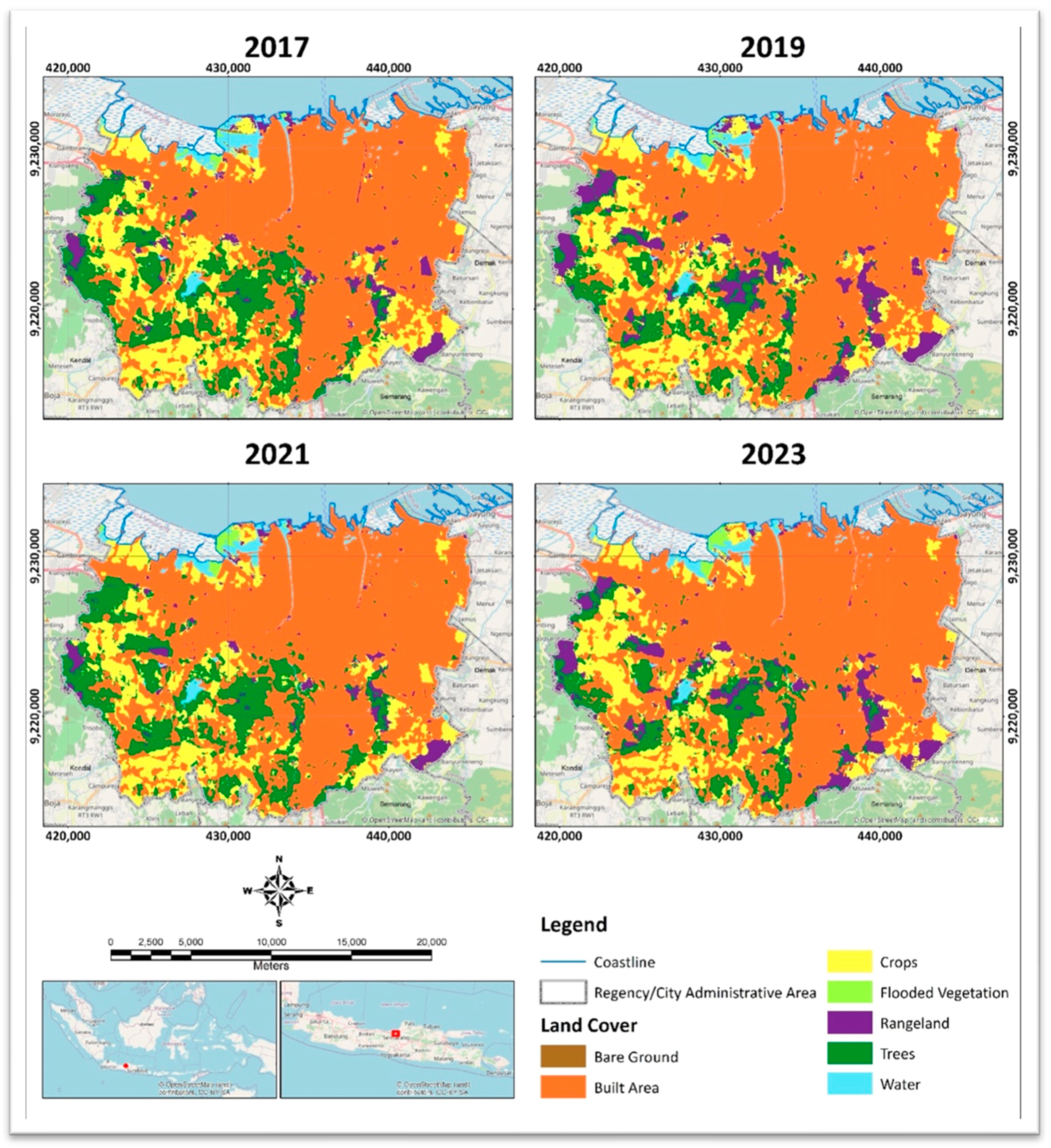
  • Data Acquisition and Pre-Processing: We used the Land Use Land Cover (LULC) dataset from Google Earth Engine (GEE)’s platform (server updated May 2023) together with the JavaScript client library (v0.1.383) and Python API (v0.1.383) for data processing and visualization [80], which provides 10-meter spatial resolution maps derived from Sentinel-2 imagery using a deep learning-based classification approach. This dataset was selected for its high temporal (available for 2017, 2019, 2021, and 2023) and spatial resolution, which is suitable for detecting detailed changes in urban land cover. The GEE LULC dataset offers a pre-processed and validated product, reducing the need for extensive in-house pre-processing [81,82,83].
  • Processing and Classification: The LULC data were classified into seven distinct land cover classes: built area, crops, trees, rangeland, flooded vegetation, bare ground, and water. The primary analytical focus was on the change in the built area class over the study period, which was processed using ArcGIS 10.8 software. We used the “Change Detection Wizard” tool in ArcGIS to quantify the area of land converted from other classes to built-up areas between the different time steps (e.g., 2017 to 2023).
  • Post-Processing and Validation: The LULC change maps were post-processed through a combination of visual interpretation and a formal accuracy assessment [21,84]. We validated the GEE LULC data by comparing it with high-resolution reference maps from Google Earth and other geospatial datasets. A random sample of 250 points was used to calculate the overall accuracy and Kappa coefficient of the LULC classifications, confirming the data’s reliability for change detection analysis. This step ensures that our change detection results are based on a reliable and validated land cover classification.

2.4. Data Integration and Analysis

The qualitative and quantitative data were integrated to provide a robust, multi-faceted analysis. The spatial data on subsidence rates and land cover change were mapped and used to spatially contextualize the qualitative themes. For instance, we overlaid the InSAR-derived subsidence maps with the locations of FGDs and interviews to examine how community perceptions of flooding and infrastructure effectiveness align with the measured rates of land sinking in their specific neighborhoods. This qualitative-quantitative triangulation allowed us to connect the “what” (the observed physical change) with the “why” and “how” (the human experiences, governance challenges, and policy implications), thereby addressing the reviewer’s concern about the lack of a “reasonable theoretical-practical methodology.” This integrated approach strengthens the study’s findings and provides a more comprehensive understanding of the socio-spatial dynamics of land subsidence.

3. Results

This section presents the findings from the integrated mixed-methods analysis, connecting the quantitative geospatial data on land subsidence and land cover change with qualitative insights from local stakeholders. The results are structured to demonstrate how these different data streams converge to explain the complex socio-hydrological dynamics of flood risk in Semarang.

3.1. Anthropogenic Activities and Urbanization

The industrial sector has driven significant population growth and coastal urban expansion in Semarang, particularly in the northern districts of North Semarang, West Semarang, and Genuk. The population of Semarang City reached 1,653,524 in 2023, with a density of 4534 people per km2 and an annual growth rate of 0.87%. This rapid urbanization, especially in the low-lying coastal areas, has led to a sprawling development pattern that poses challenges for public infrastructure and services. Our qualitative findings reveal that the limited provision of clean water in these newly developed areas forces communities to rely on groundwater extraction. This practice, despite existing regulations, remains widespread due to insufficient access to alternative water sources, creating a direct link between anthropogenic activities and the exacerbation of land subsidence.
According to the population census [65,66], Semarang City has a population of 1,653,524 and a land area of 373.70 km2. In 2023, Semarang City’s population is expected to expand at a rate of 0.87 per year, with a density of 4534 per km2. The drive of the industrial sector has resulted in rapid coastal development, particularly in the northern districts of North Semarang, West Semarang, and Genuk. According to the local Central Statistics Agency, population and industrial activity have increased in these locations.
Historically, Semarang City began as a development center in the coastal areas. Since the Dutch colonial era, the coastal regions have functioned as centers of social and economic activities. However, recent trends have shown the shifting of urban development’s physical and cultural trends. The growth of residential areas in the southern part of the city of the upper land has increased gradually. However, the growing physical infrastructure in the northern part of the city has caused a sprawling pattern, which has caused challenges in transportation services and related public facilities for the local communities. Therefore, informal housing and slums were growing in some areas surrounding industrial areas in the coastal regions. The clean water provision is limited in the respective areas, forcing people and communities to utilize groundwater as a clean water resource. Even though activities are not allowed based on regulations, they are difficult to control due to insufficient access to water resources. Therefore, land subsidence has rapidly increased, followed by the increased sea level that caused the uncertain impact of tidal floods.

3.2. Natural Processes and Geological Factors

As previously noted, Semarang suffers significant ground deformation, primarily caused by land subsidence. Previous studies in Semarang have reported increased deformation rates detected using the InSAR technique between 2007 and 2009 and found subsidence rates ranging from 7 to 13 cm/yr [10,85]. Furthermore, a study conducted from 2015 to 2022 discovered a maximum subsidence rate of 10–12 cm/year in the northern and eastern sections of Semarang [38] and, from 2014 to 2023, the most significant observed subsidence rate over the 8.4 years was roughly 11 cm/year [11,33].
Land subsidence in Semarang City has significant consequences for urban and natural areas. According to Sarah et al., groundwater exploitation accounts for 74–82% of overall subsidence, with building load accounting for 18–26%. If land subsidence continues to exist, it is expected to cause IDR 76 trillion in economic losses (2020–2040) due to the cost of repairing damaged roads, increasing the risk of flooding, decreasing the attractiveness of the business climate, and lowering the community’s quality of life. Future research should focus on improving water management and land use restrictions to mitigate land subsidence and incorporate it into spatial planning projects.
In the study area, land subsidence shows a continuous downward tendency from late 2014 to mid-2023 when compared to Semarang City Center (Point 1), which experienced land subsidence at a very low rate. In Karangroto (Point 2) and Sembungharjo (Point 4), the subsidence rates vary from −8.8 cm/year to −10.1 cm/year (Figure 3a,b). A single pixel representing an 80 × 80 m2 area was the basis for these observations and the InSAR processing’s spatial unit [40]. The pixels that depict Karangroto and Sembungharjo are separated by around 2 km, although the rates of land subsidence vary by roughly 2 cm/year. Furthermore, the figure exhibits a little upward trend at the start of the year, most likely as a result of processes for replenishment that take place during the rainy season.
InSAR time-series analysis from 2014 to 2023 reveals clear trends of land subsidence across the selected districts, with varying rates that reflect localized hydrogeological and anthropogenic factors. Figure 3 illustrates the cumulative displacement in each sub-district, highlighting consistent subsidence patterns over time. These findings provide quantitative support for stakeholder concerns and demonstrate the urgent need for long-term planning and policy intervention. While this study does not include forward projections, the observed trends underscore the importance of incorporating future scenario modeling in subsequent research.

3.3. Land Use Change and Urban Expansion

The quantitative analysis of land cover change from 2017 to 2023, based on Sentinel-2 data processed through Google Earth Engine, confirms a significant trend of urban expansion. Our change detection analysis in ArcGIS 10.8 using the “Change Detection Wizard” tool quantified the expansion of Built Area, which increased from 21,512 hectares in 2017 to 23,755 hectares in 2023. This expansion occurred primarily at the expense of Cropland, which diminished from 6879 ha to 5624 ha, and tree cover, which decreased from 11,871 ha to 11,043 ha (Figure 4).
The built area in the city has shown a steady expansion, rising from 21,512 hectares in 2017 to 23,755 hectares in 2023, underscoring the continuous urban development, especially in the central and northern districts. This expansion predominantly occurred at the expense of agricultural and vegetative lands. Cropland diminished notably from 6879 ha to 5624 ha, indicating increasing development pressure and potential shifts in land use policy and economic objectives. The area occupied by trees decreased from 11,871 ha to 11,043 ha, a slight fall likely due to land conversion on the periphery of urban areas, alongside conservation initiatives in protected areas. Rangeland experienced minor variations, ranging from 3029 ha to 3306 ha, indicating that land use in this category remained comparatively steady. Flooded vegetation demonstrated temporal fluctuations, reaching a maximum of 1243 hectares in 2021 before decreasing to 1087 hectares by 2023, likely due to seasonal hydrological shifts or anthropogenic changes in water management. Bare Ground decreased sharply from 56 hectares in 2017 to slightly over 3 hectares in 2023, possibly reflecting areas cleared for temporary construction or land preparation. The water bodies exhibited minimal changes throughout the investigated timeframe. The trends evident in the classified maps validated these changes, showing the expansion of built areas as dense clusters extending outward, while cropland and tree cover experienced fragmentation and contraction. These findings correspond with the broader development patterns observed in coastal Java and underscore the increasing challenge of reconciling urban expansion with land conservation.

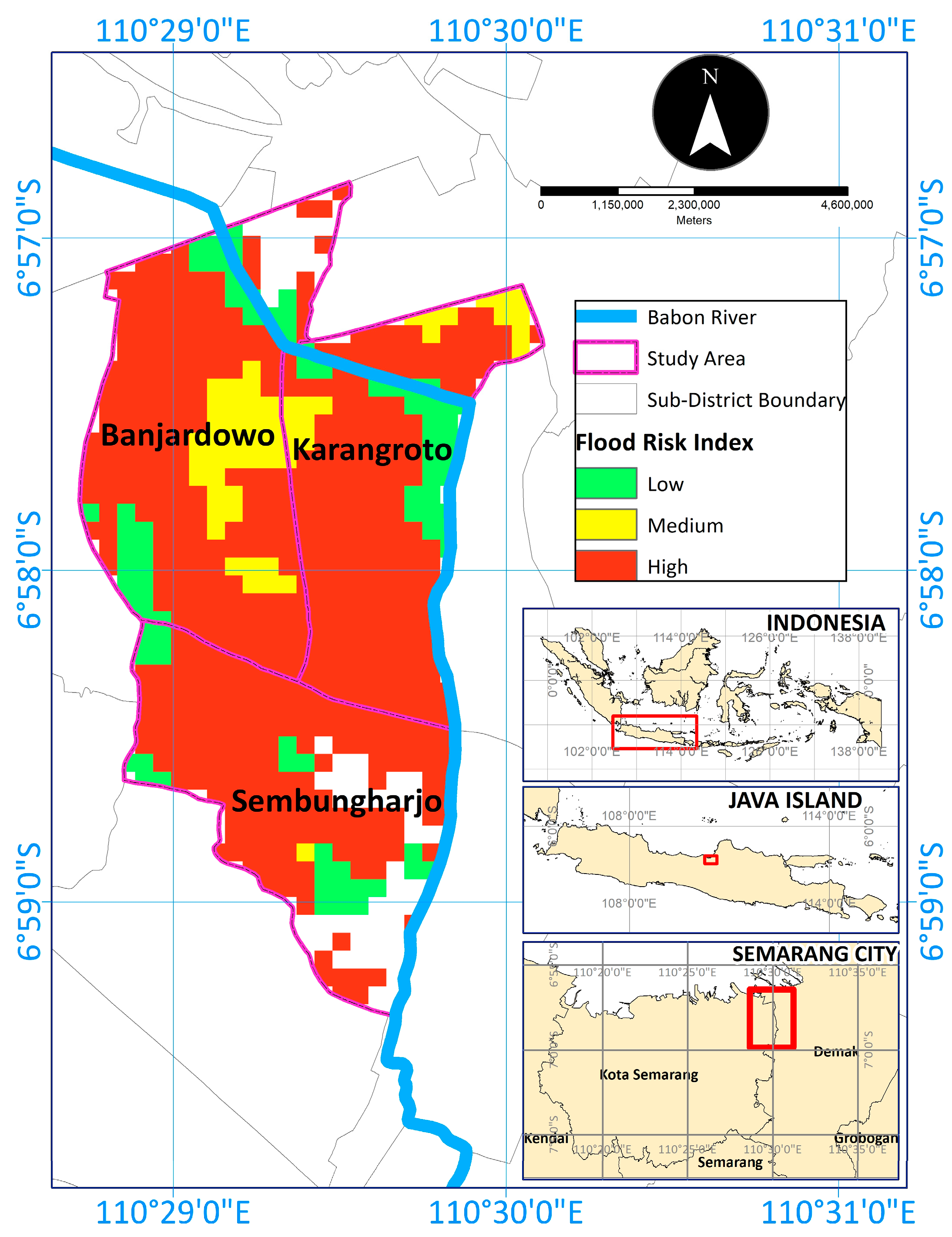
3.4. Increased Flood Risk: An Integrated Analysis of Physical and Human Factors

Our integrated analysis reveals that increased flood risk is a direct consequence of the interplay between land subsidence, land use change, and overwhelmed infrastructure. The spatial distribution of high flood risk areas, as indicated by BNPB data, shows that Banjardowo has the largest contiguous area of high flood risk, followed by Karangroto and Sembungharjo, highlighting significant spatial variations in vulnerability [74]. Our findings from systematic field observations and qualitative interviews corroborate the influence of high tides and inadequate drainage, which are exacerbated by land subsidence. The qualitative data revealed that stakeholders perceive floods as the primary problem, often linking them to ineffective government programs and infrastructure, such as elevated roadways that inadvertently redirect water into residential areas. This spatial distribution is consistent with reports of escalating flood incidents within these localities.
Initial investigations suggest that the observed increase in flood risk across these three sub-districts is attributable to a confluence of interacting factors. Notably, BNPB data and our field observations corroborate the assertion of amplified flood discharge from upstream catchments (Figure 5). This surge in discharge is likely a direct consequence of extensive land-use changes, particularly the rapid conversion of natural land cover to impermeable surfaces, as observed through remote sensing analysis. The increase in impermeable surfaces prevents rainwater from infiltrating the ground, leading to increased runoff and higher river discharge. The excessive land use change, in turn, overwhelms the existing drainage infrastructure, increasing the likelihood of flooding.
Furthermore, the influence of high tides, exacerbated by the complex interplay of inadequate drainage infrastructure and land subsidence, cannot be discounted. Land subsidence, particularly pronounced in coastal regions, is a critical factor, as previous research shows. Our preliminary analysis corroborates the trend observed in Subang [86], where coastal vulnerability is heightened by subsidence. Previous studies emphasize that subsidence reduces the relative height of urban surfaces and compromises the effectiveness of gravity-based drainage systems [43,87,88]. This combination exacerbates the risk of both tidal and pluvial flooding. The pronounced land subsidence aligns with our data, suggesting a shared vulnerability across diverse coastal settings [89,90,91,92]. The convergence of these studies underscores the critical role of subsidence in exacerbating flood risk, warranting further investigation into its complex interactions with hydrological and anthropogenic factors within our Semarang context.
Land subsidence exacerbates flood risk by lowering terrain elevation to mean sea level and river base levels, therefore augmenting the extent and duration of flooding. Progressive subsidence converts moderately flood-prone regions into places of persistent tidal and pluvial vulnerability, even in modest hydrometeorological conditions. Moreover, subsiding surfaces demonstrate diminished hydraulic gradients, hindering natural drainage and extending hydroperiods. The transition from episodic to prolonged flooding patterns increases infrastructure susceptibility and societal instability.
The accelerated urbanization of Semarang’s coastal zones, marked by a rapid surge in built-up areas, significantly amplifies flood vulnerability. As documented, this expansion directly correlates with heightened land subsidence rates, a critical factor in exacerbating inundation risk. The proliferation of impermeable surfaces and the compaction of subsurface strata inherent to urban development contribute to this subsidence. Consequently, drainage capacity is compromised, and the region’s susceptibility to tidal and pluvial flooding increases. This interplay between rapid urbanization and hydro-geomorphic processes necessitates a nuanced understanding of coastal flood dynamics.

3.5. Stakeholder Perspectives and Conflicting Narratives

Semarang has faced significant ground deformation at the city level, with increasing land subsidence confirmed. Despite this, the city’s mitigation and adaptation strategies predominantly address the impacts of land subsidence, particularly flooding. Both tidal and riverine floods have caused substantial economic losses at the city and national levels. Additionally, Semarang is dealing with the effects of climate change, which exacerbate rainfall intensity and frequency, further increasing the flooding potential. The city has experienced severe inundation along national roads and surrounding residential areas.
The government of Semarang has applied several adaptation measures to address land subsidence. Integrated methods for strengthening urban infrastructure’s resistance to the effects of climate change, such as increasing sea levels and land subsidence, are among them. Among these measures are the construction of elevated flood barriers, flood-control structures, and risk management techniques to mitigate tidal floods’ effects. Additionally, the government has prioritized improving the drainage systems and upgrading pumping stations. Furthermore, to encourage sustainable water management techniques, the municipal government has also tightened restrictions on groundwater extraction and launched public awareness programs. The city can support a safer and more sustainable urban environment through increased resilience to climate change and ground subsidence. In order to improve the city’s ability to resist future floods and lessen the effects of land subsidence and climate change, strategies such as building flood-resistant infrastructure and adding green spaces have been implemented.
In 2010, Semarang was selected as one of the 100 Resilient Cities by the Rockefeller Foundation. This designation facilitated the development of integrated and practical approaches to address the increased risks associated with climate change, from sea level rise to droughts affecting water supply. The city’s resilience strategies encompass structural and non-structural approaches, including capacity building for policymakers and strengthening institutional capacity to manage climate change risks (Table 2).
Apart from implementing structural measures to prevent floods and utilizing grey solutions, the city administration also employs an ecosystem services approach, primarily concentrating on mangrove restoration initiatives in coastal areas. The results highlight stakeholder analysis at the sub-district level to understand how local governments perceive environmental conditions, vulnerabilities, and disaster risks. Although land subsidence is the subject of this study, it is not a primary concern at the local level. Instead, the local focus is on flooding, resulting from land subsidence due to the city’s geographical and geomorphological characteristics. Stakeholders at the sub-district level are primarily involved in implementing city government programs and do not engage in exceptional adaptation infrastructure development beyond the standard measures (Table 3).

3.6. Local Stakeholders’ Perspectives on Land Subsidence Using the Proxy of Floods

Our integrated approach allowed for a critical assessment of existing mitigation efforts from both a technical and a governance perspective. The field observations and geospatial analysis indicate a persistent trend of increased inundation despite existing mitigation protocols, such as flood barriers and upgraded pumping stations. The qualitative data from interviews and FGDs provided a deeper understanding of the limitations and challenges of these interventions. Stakeholders expressed concerns about the “ineffectiveness of government programs,” a sentiment directly supported by our observations of sub-optimal dredging schedules and a marked increase in sediment deposition in drainage channels. The analysis of the qualitative data, summarized in Table 3 and Table 4, highlights key issues:
  • Technical shortcomings: Interventions like road elevation have unintended consequences, exacerbating flooding in residential areas.
  • Institutional mismatches: There is a clear conflict between national interests (protecting highways) and local needs, leading to misaligned flood management efforts.
  • Organizational capacity gaps: The focus on “grey solutions” like embankments often fails to address the root cause of the problem—excessive groundwater extraction.
The findings from Table 4 emphasize the interaction between institutional mismatches, technological shortcomings, and organizational capacity shortages, underscoring the pressing need for more comprehensive, multi-level governance initiatives. Without a comprehensive and coordinated response, flooding exacerbated by land subsidence will persist. Better coordination between national and local flood control priorities, increased institutional capacity, and a dedication to addressing the environmental drivers of land subsidence are necessary to address the immediate effects of floods and the root causes of land subsidence.
These qualitative findings, when viewed in light of the quantitative land subsidence and land use change data, underscore the need for a more comprehensive approach. The stakeholder-proposed interventions, such as stricter land-use regulations and the promotion of green infrastructure, are directly supported by our geospatial findings, which show rapid urban expansion as a key driver of subsidence and runoff.

3.7. Identification of Competing Narratives and Conflicting Viewpoints

The term land subsidence was unfamiliar to most residents, who heard about it through news media and the local BPBD. Although residents in the three subdistricts acknowledged that land subsidence exacerbated flooding, discussions about it were less frequent than discussions about the impacts of flooding. In FGDs with subdistrict officials and residents to explore community perceptions, adaptation strategies, and future flood risks, diverse perspectives on flooding were revealed—the majority of participants associated flooding with natural events caused by natural factors. A participant from Banjardowo Subdistrict, affected by annual floods, explained that the name “Genuk” in Javanese, meaning “urn,” reflects the bowl-shaped geographical contour of the Genuk district.
Consequently, the community believes flooding will persist in the Genuk district despite advanced adaptation strategies and technologies. One resident stated, “Humans cannot fight nature, so humans must accept and live in harmony with the flood conditions” (Banjardowo Informant, personal communication, 25 October 2023). An optimistic narrative was also expressed, stating the need for comprehensive efforts beyond downstream areas and seeking the construction of sea walls. For example, residents of Karangroto view sea dike infrastructure and pumping systems as the most suitable adaptation strategies for their area (Karangroto Informant, personal communication, 26 October 2023).
In the FGD, two dominant community narratives were found. The first is a fatalistic view, where ongoing exposure to floods without effective solutions has led to despair. For example, a 52-year-old Sembungharjo resident who has experienced floods throughout his life accepts the situation and chooses not to relocate due to his attachment to his birthplace. The second narrative focuses on technical fixes, reflecting the community’s optimism that infrastructure solutions like sea dikes can address flooding. However, the community’s current narrative does not yet integrate land subsidence as a crucial factor in flood risk reduction.

3.8. Assessment of Effectiveness and Limitations of Current Approaches

Our integrated findings from field investigations and stakeholder interviews reveal that flood inundation persists and even increases despite existing mitigation efforts. This can be attributed to the combined effects of intensifying anthropogenic pressures and hydro-geomorphic changes.
Spatial analysis confirms a direct link between accelerated urbanization and reduced groundwater recharge, as the expansion of impermeable surfaces in critical catchment zones prevents rainwater infiltration. This process, in turn, fuels land subsidence. Furthermore, field surveys document increased sediment deposition in drainage channels, which, coupled with sub-optimal dredging schedules, significantly reduces their capacity to handle floodwaters.
Qualitative feedback from interviews and FGDs highlights a critical disconnect between current mitigation strategies and the escalating flood risk, suggesting that existing protocols are ineffective against the scale of the problem. Stakeholders propose augmented interventions, including accelerated dredging, stricter land-use regulations to reduce impervious surfaces, and the implementation of green infrastructure. These proposed solutions are directly supported by our spatial analysis, which emphasizes the urgent need for a shift toward integrated urban planning that prioritizes ecological resilience.

4. Discussion

This study’s interdisciplinary approach reveals a critical disconnect between scientifically identified risk and community-level risk perception in Semarang. While our InSAR time-series analysis (2014–2023) identifies land subsidence as a fundamental driver of environmental vulnerability, local narratives are predominantly framed around flooding as the primary hazard. This disconnect is starkly visible in the Sembungharjo sub-district; our analysis reveals a steady subsidence rate of −10.1 cm/year, yet a 52-year-old Sembungharjo resident who has experienced floods his entire life expressed a sense of fatalism, accepting the situation as a recurring reality to be lived with. The widespread and gradual nature of subsidence has rendered the ground deformation a “silent disaster,” minimizing its immediate visual impact and contributing to limited public awareness.
Understanding the reasons for this perception gap is crucial for developing effective policy. The predominant focus on flooding may stem from its immediate visibility and disruptive impact, in contrast to subsidence’s slow, almost imperceptible nature, which often develops over the years. Furthermore, public narratives are often shaped by more tangible proposed solutions, such as the community’s preference for technical fixes like sea dikes rather than complex hydrogeological management. This phenomenon is not unique to Semarang. Similar disconnects have been observed in other global contexts, such as the San Francisco Bay Area and Bergen, Norway [2,88,93,94,95,96]. Likewise, the governance challenges identified—including insufficient coordination across governmental levels and the absence of a comprehensive ecosystem-based plan —resonate with findings from other studies on urban flood resilience.
These findings underscore the need for a paradigm shift in urban disaster management, moving beyond traditional infrastructure solutions to embrace a more holistic and integrated approach. Although various structural measures have been implemented to address flooding, they often conflict with national programs and fail to tackle the underlying risk drivers. This study promotes improved risk communication, strengthened multi-level governance collaboration, and the incorporation of nature-based solutions to build urban resilience. A comprehensive and flexible management framework should integrate technical, institutional, and community-based methodologies. Effective collaboration across all levels of government and active stakeholder participation is crucial to address the twin challenges of floods and land subsidence, ensuring that future urban development aligns with disaster resilience and environmental sustainability goals.
While this research provides a holistic assessment of the land subsidence issue by combining qualitative and quantitative data, we acknowledge its limitations. First, our governance data relied heavily on sub-district officials, which may overlook perspectives from higher-level city and provincial authorities responsible for policy formulation. This may limit the direct applicability of our governance findings primarily to the policy implementation level. Second, the study’s focus on “land subsidence” as the primary driver may have biased recommendations given the limited local knowledge of the term; this highlights that our proposed technical solutions must be preceded by robust community engagement.
Looking ahead, these limitations directly inform our recommendations for future research. Future work should address these gaps by incorporating a broader range of stakeholders and geographical areas. Multi-level stakeholder engagement and cross-comparative analyses with control groups would provide more comprehensive insights into flood risk management. Furthermore, given the potential for future environmental changes, such as accelerated sea-level rise, future research should incorporate scenario-based modeling, integrating climate change projections with socio-economic development pathways, to assess the long-term resilience of Semarang City. A longitudinal study tracking the evolution of community risk perceptions and adaptation behaviors in response to evolving environmental pressures would also be valuable. These efforts will contribute to a more dynamic understanding of how socio-ecological systems adapt over time and facilitate the development of more robust, future-proof urban disaster risk reduction strategies.

5. Conclusions

This interdisciplinary study of Semarang, Indonesia, comprehensively reveals a critical disconnect between scientifically identified environmental risks and local community hazard perceptions. Our InSAR time-series analysis (2014–2023) confirms that significant land subsidence is the fundamental issue exacerbating flood vulnerability. Findings indicate high subsidence rates, with line-of-sight displacement measurements showing a continuous downward trend from late 2014 to mid-2023, varying from −8.8 to −10.1 cm/year in areas like Karangroto and Sembungharjo. This occurs alongside rapid urban expansion, where built-up areas notably increased from 21,512 hectares in 2017 to 23,755 hectares in 2023, at the expense of natural cover, and groundwater extraction remains a dominant driver. Despite this clear physical evidence, community narratives and existing mitigation efforts remain predominantly focused on managing flooding as a separate, primary hazard. This misalignment is profoundly impactful: adaptation strategies often fail to address the problem’s root cause, further hampered by a fragmented governance framework that lacks sufficient coordination between administrative levels. As highlighted by our qualitative data, this leads to a “fatalistic view” among some residents and a preference for “technical fixes” that do not address the underlying subsidence, a phenomenon observed in other global contexts.
The primary contribution of this research is its detailed analysis of how this perception gap, combined with systemic governance challenges, critically undermines urban resilience in a rapidly sinking coastal city. The key implication for policymakers in Semarang and other vulnerable coastal cities is the urgent need for a paradigm shift in disaster management. Current flood-centric approaches are insufficient. To build sustainable resilience, public and political focus must broaden from the symptoms, namely flooding, to the underlying driver of land subsidence, a process that requires vastly improved risk communication, multi-level collaboration, and integrated policymaking. Our findings underscore the necessity of moving towards a comprehensive urban management framework that integrates governance reform, nature-based solutions, and enhanced community participation, ensuring future urban development aligns with disaster resilience and environmental sustainability goals.

Author Contributions

Conceptualization, S.A.D., B.H.S., G.A.K.S., A.F.A.R., R.A., S.P., A.A., T.I. and R.P.; methodology, S.A.D., B.H.S., G.A.K.S., A.F.A.R. and A.A.; software, A.A.; validation, S.A.D., B.H.S., G.A.K.S., A.F.A.R., A.A., R.A. and S.P.; formal analysis, S.A.D., B.H.S., G.A.K.S., A.F.A.R., R.A., S.P., A.A., T.I. and R.P.; investigation, S.A.D., B.H.S., G.A.K.S., A.F.A.R., R.A., S.P. and A.A.; resources, A.A., B.H.S. and R.P.; data curation, S.A.D., B.H.S., G.A.K.S., A.F.A.R., R.A., S.P., A.A., T.I. and R.P.; writing—original draft preparation, S.A.D., B.H.S., G.A.K.S., A.F.A.R., R.A., S.P., A.A., T.I. and R.P.; writing—review and editing, S.A.D., B.H.S., G.A.K.S., A.F.A.R., R.A., S.P., A.A., T.I. and R.P.; visualization, A.A.; supervision, R.P., B.H.S. and T.I.; project administration, B.H.S.; funding acquisition, R.P. and B.H.S. All authors have read and agreed to the published version of the manuscript.

Funding

This research was funded by the Directorate of Research and Development, University of Indonesia, under Hibah PUTI 2023 [Grant No. NKB-842/UN2.RST/HKP.05.00/2023].

Institutional Review Board Statement

We confirm that all procedures involving human participants were conducted in accordance with national and international ethical standards. Prior to data collection, ethical approval for the study was obtained from the National Research and Innovation Agency (BRIN), Indonesia, ensuring compliance with the 1964 Helsinki Declaration and its later amendments or comparable ethical standards.

Informed Consent Statement

All participants were fully informed about the purpose of the study, the voluntary nature of their participation, and their right to withdraw at any time without consequence.

Data Availability Statement

The data supporting the findings of this study are available from the corresponding author upon request.

Acknowledgments

The authors are grateful for the support provided by Hibah PUTI Universitas Indonesia.

Conflicts of Interest

The authors declare no conflicts of interest.

References

  1. Bakr, M. Influence of Groundwater Management on Land Subsidence in Deltas: A Case Study of Jakarta (Indonesia). Water Resour. Manag. 2015, 29, 1541–1555. [Google Scholar] [CrossRef]
  2. Ilia, I.; Loupasakis, C.; Tsangaratos, P. Land Subsidence Phenomena Investigated by Spatiotemporal Analysis of Groundwater Resources, Remote Sensing Techniques, and Random Forest Method: The Case of Western Thessaly, Greece. Environ. Monit. Assess. 2018, 190, 623. [Google Scholar] [CrossRef]
  3. Suripin; Pujiastuti, R.; Widjonarko. The Initial Step for Developing Sustainable Urban Drainage System in Semarang City-Indonesia. Procedia Eng. 2017, 171, 1486–1494. [Google Scholar] [CrossRef]
  4. Fan, Y.; Lyu, X. Exploring Two Decades of Research in Community Resilience: A Content Analysis across the International Literature. Psychol. Res. Behav. Manag. 2021, 14, 1643–1654. [Google Scholar] [CrossRef]
  5. Yan, X.; Xu, Y.; Yang, T.; Tosi, L.; Stouthamer, E.; Minderhoud, P.; Teatini, P.; Kooi, H.; Andreas, H.; Pradipta, D.; et al. Sustainable Development of Coastal Cities through Control of Land Subsidence: Activities of IGCP Project 663 in Jakarta. Epis. J. Int. Geosci. 2022, 45, 101–108. [Google Scholar] [CrossRef]
  6. Akitaya, K.; Aichi, M. Land Subsidence Caused by Seasonal Groundwater Level Fluctuations in Kawajima (Japan) and One-Dimensional Numerical Modeling with an Evolutionary Algorithm. Hydrogeol. J. 2023, 31, 147–165. [Google Scholar] [CrossRef]
  7. Aversa, P.; Bettinelli, C.; Levanti, G.; Destri, A.M.L.; Picone, P.M. Leveraging Intersections in Management. J. Manag. Gov. 2024, 28, 687–705. [Google Scholar] [CrossRef]
  8. Adger, W.N.; Hughes, T.P.; Folke, C.; Carpenter, S.R.; Rockström, J. Social-Ecological Resilience to Coastal Disasters. Science 2005, 309, 1036–1039. [Google Scholar] [CrossRef]
  9. Berke, P.R.; Quiring, S.M.; Olivera, F.; Horney, J.A. Addressing Challenges to Building Resilience Through Interdisciplinary Research and Engagement. Risk Anal. 2021, 41, 1248–1253. [Google Scholar] [CrossRef]
  10. Yuwono, B.D.; Abidin, H.Z.; Poerbandono; Andreas, H.; Pratama, A.S.P.; Gradiyanto, F. Mapping of Flood Hazard Induced by Land Subsidence in Semarang City, Indonesia, Using Hydraulic and Spatial Models. Nat. Hazards 2024, 120, 5333–5368. [Google Scholar] [CrossRef]
  11. Agustan, A.; Purwana, R.; Santosa, B.H.; Ito, T.; Ardiyanto, R.; Sadmono, H. Time Series InSAR for Ground Deformation Observation in Semarang Area, Central Java. In Proceedings of the 2023 8th Asia-Pacific Conference on Synthetic Aperture Radar (APSAR), Bali, Indonesia, 23–27 October 2023. [Google Scholar] [CrossRef]
  12. Agustan, A.; Roza, D.; Kausar, K. Towards a framework for disaster risk reduction in indonesia’s urban tourism industry based on spatial information. Geogr. Tech. 2019, 14, 38. [Google Scholar] [CrossRef]
  13. Khadiyanta, P.; Dewantari, S. Settlement Adaptation by Reshaping Dwellings in the Degrading Area at Genuk Disctrict of Semarang City, Indonesia. Procedia Soc. Behav. Sci. 2016, 227, 309–316. [Google Scholar] [CrossRef]
  14. Sejati, A.W.; Buchori, I.; Rudiarto, I. The Spatio-Temporal Trends of Urban Growth and Surface Urban Heat Islands over Two Decades in the Semarang Metropolitan Region. Sustain. Cities Soc. 2019, 46, 101432. [Google Scholar] [CrossRef]
  15. Sejati, A.W.; Buchori, I.; Kurniawati, S.; Brana, Y.C.; Fariha, T.I. Quantifying the Impact of Industrialization on Blue Carbon Storage in the Coastal Area of Metropolitan Semarang, Indonesia. Appl. Geogr. 2020, 124, 102319. [Google Scholar] [CrossRef]
  16. Neise, T.; Revilla Diez, J. Adapt, Move or Surrender? Manufacturing Firms’ Routines and Dynamic Capabilities on Flood Risk Reduction in Coastal Cities of Indonesia. Int. J. Disaster Risk Reduct. 2019, 33, 332–342. [Google Scholar] [CrossRef]
  17. Bott, L.M.; Braun, B. How Do Households Respond to Coastal Hazards? A Framework for Accommodating Strategies Using the Example of Semarang Bay, Indonesia. Int. J. Disaster Risk Reduct. 2019, 37, 101177. [Google Scholar] [CrossRef]
  18. Prana, A.M.; Dionisio, R.; Curl, A.; Hart, D.; Gomez, C.; Apriyanto, H.; Prasetya, H. Informal Adaptation to Flooding in North Jakarta, Indonesia. Prog. Plan. 2024, 186, 100851. [Google Scholar] [CrossRef]
  19. Widodo, J.; Trihatmoko, E.; Khomarudin, M.R.; Ardha, M.; Nugroho, U.C.; Setyaningrum, N.; Dinanta, G.P.; Arief, R.; Setiyoko, A.; Novresiandi, D.A.; et al. Dynamic Geo-Visualization of Urban Land Subsidence and Land Cover Data Using PS-InSAR and Google Earth Engine (GEE) for Spatial Planning Assessment. Urban Sci. 2024, 8, 234. [Google Scholar] [CrossRef]
  20. Koch, M.; Gaber, A.; Darwish, N.; Bateman, J.; Gopal, S.; Helmi, M. Estimating Land Subsidence in Relation to Urban Expansion in Semarang City, Indonesia, Using InSAR and Optical Change Detection Methods. In Proceedings of the IGARSS 2019—2019 IEEE International Geoscience and Remote Sensing Symposium, Yokohama, Japan, 28 July–2 August 2019; pp. 9686–9689. [Google Scholar] [CrossRef]
  21. Lo, W.; Purnomo, S.N.; Dewanto, B.G.; Sarah, D. Sumiyanto Integration of Numerical Models and InSAR Techniques to Assess Land Subsidence Due to Excessive Groundwater Abstraction in the Coastal and Lowland Regions of Semarang City. Water 2022, 14, 201. [Google Scholar] [CrossRef]
  22. Santos-Lacueva, R.; Ariza, E.; Romagosa, F.; Saladié, Ò. The Vulnerability of Destinations to Climate Change: A Comparative Analysis of Contextual Socio-Political Factors. J. Sustain. Tour. 2019, 27, 1217–1238. [Google Scholar] [CrossRef]
  23. Peek, L.; Tobin, J.; Adams, R.M.; Wu, H.; Mathews, M.C. A Framework for Convergence Research in the Hazards and Disaster Field: The Natural Hazards Engineering Research Infrastructure CONVERGE Facility. Front. Built. Envrion. 2020, 6, 551252. [Google Scholar] [CrossRef]
  24. Berke, P.; Yu, S.; Malecha, M.; Cooper, J. Plans That Disrupt Development: Equity Policies and Social Vulnerability in Six Coastal Cities. J. Plan. Educ. Res. 2023, 43, 150–165. [Google Scholar] [CrossRef]
  25. Davidson, R.A. Integrating Disciplinary Contributions to Achieve Community Resilience to Natural Disasters. Civ. Eng. Environ. Syst. 2015, 32, 55–67. [Google Scholar] [CrossRef]
  26. Lawlor, A.; Crow, D. Risk-Based Policy Narratives. Policy Stud. J. 2018, 46, 843–867. [Google Scholar] [CrossRef]
  27. Marchezini, V. The Biopolitics of Disaster: Power, Discourses, and Practices. Hum. Organ. 2015, 74, 362–371. [Google Scholar] [CrossRef]
  28. Coates, R. Citizenship-in-Nature? Exploring Hazardous Urbanization in Nova Friburgo, Brazil. Geoforum 2019, 99, 63–73. [Google Scholar] [CrossRef]
  29. Tierney, K.J. From the Margins to the Mainstream? Disaster Research at the Crossroads. Annu. Rev. Sociol. 2007, 33, 503–525. [Google Scholar] [CrossRef]
  30. Sarah, D.; Hutasoit, L.M.; Delinom, R.M.; Sadisun, I.A. Natural Compaction of Semarang-Demak Alluvial Plain and Its Relationship to the Present Land Subsidence. Indones. J. Geosci. 2020, 7, 273–289. [Google Scholar] [CrossRef]
  31. Marfai, M.A.; King, L. Monitoring Land Subsidence in Semarang, Indonesia. Environ. Geol. 2007, 53, 651–659. [Google Scholar] [CrossRef]
  32. Kuehn, F.; Albiol, D.; Cooksley, G.; Duro, J.; Granda, J.; Haas, S.; Hoffmann-Rothe, A.; Murdohardono, D. Detection of Land Subsidence in Semarang, Indonesia, Using Stable Points Network (SPN) Technique. Environ. Earth Sci. 2010, 60, 909–921. [Google Scholar] [CrossRef]
  33. Andreas, H.; Zainal Abidin, H.; Anggreni Sarsito, D.; Meilano, I.; Susilo, S. Investigating the Tectonic Influence to the Anthropogenic Subsidence along Northern Coast of Java Island Indonesia Using GNSS Data Sets. E3S Web Conf. 2019, 94, 04005. [Google Scholar] [CrossRef]
  34. Geodetic Inversion for Aquifer Damage Model in Semarang City Basin, Central Java, Indonesia. Available online: https://digilib.itb.ac.id/assets/files/2019/MjAxOSBUUyBQUCBNYWkgQ29uZyBOaHV0IDEtQUJTVFJBSy5wZGY.pdf (accessed on 27 January 2025).
  35. Lubis, A.M.; Sato, T.; Tomiyama, N.; Isezaki, N.; Yamanokuchi, T. Ground Subsidence in Semarang-Indonesia Investigated by ALOS-PALSAR Satellite SAR Interferometry. J. Asian Earth Sci. 2011, 40, 1079–1088. [Google Scholar] [CrossRef]
  36. Dodd, C.; Rishworth, G.M. Coastal Urban Reliance on Groundwater during Drought Cycles: Opportunities, Threats and State of Knowledge. Camb. Prism. Coast. Futures 2023, 1, e11. [Google Scholar] [CrossRef]
  37. Guo, H.; Zhang, Z.; Cheng, G.; Li, W.; Li, T.; Jiao, J.J. Groundwater-Derived Land Subsidence in the North China Plain. Environ. Earth Sci. 2015, 74, 1415–1427. [Google Scholar] [CrossRef]
  38. Guo, H.; Hao, A.; Li, W.; Zang, X.; Wang, Y.; Zhu, J.; Wang, L.; Chen, Y. Land Subsidence and Its Affecting Factors in Cangzhou, North China Plain. Front. Environ. Sci. 2022, 10, 1053362. [Google Scholar] [CrossRef]
  39. Aljammaz, A.; Sultan, M.; Izadi, M.; Abotalib, A.Z.; Elhebiry, M.S.; Emil, M.K.; Abdelmohsen, K.; Saleh, M.; Becker, R. Land Subsidence Induced by Rapid Urbanization in Arid Environments: A Remote Sensing-Based Investigation. Remote Sens. 2021, 13, 1109. [Google Scholar] [CrossRef]
  40. Intrieri, E.; Confuorto, P.; Bianchini, S.; Rivolta, C.; Leva, D.; Gregolon, S.; Buchignani, V.; Fanti, R. Sinkhole Risk Mapping and Early Warning: The Case of Camaiore (Italy). Front. Earth Sci. 2023, 11, 1172727. [Google Scholar] [CrossRef]
  41. Hansen, G.; Stone, D. Assessing the Observed Impact of Anthropogenic Climate Change. Nat. Clim. Change 2016, 6, 532–537. [Google Scholar] [CrossRef]
  42. Mezősi, G. Climate Change and Its Impacts. In Natural Hazards and the Mitigation of their Impact; Springer: Berlin/Heidelberg, Germany, 2022; pp. 241–261. [Google Scholar] [CrossRef]
  43. De Zoysa, R.S.; Schöne, T.; Herbeck, J.; Illigner, J.; Haghighi, M.; Simarmata, H.; Porio, E.; Rovere, A.; Hornidge, A.K. The ‘Wickedness’ of Governing Land Subsidence: Policy Perspectives from Urban Southeast Asia. PLoS ONE 2021, 16, e0250208. [Google Scholar] [CrossRef]
  44. García-Soriano, D.; Quesada-Román, A.; Zamorano-Orozco, J.J. Geomorphological Hazards Susceptibility in High-Density Urban Areas: A Case Study of Mexico City. J. S. Am. Earth Sci. 2020, 102, 102667. [Google Scholar] [CrossRef]
  45. Nurhidayah, L.; Davies, P.; Alam, S.; Saintilan, N.; Triyanti, A. Responding to Sea Level Rise: Challenges and Opportunities to Govern Coastal Adaptation Strategies in Indonesia. Marit. Stud. 2022, 21, 339–352. [Google Scholar] [CrossRef]
  46. Artiningsih; Setyono, J.S.; Yuniartanti, R.K. The Challenges of Disaster Governance in an Indonesian Multi-Hazards City: A Case of Semarang, Central Java. Procedia Soc. Behav. Sci. 2016, 227, 347–353. [Google Scholar] [CrossRef]
  47. Colven, E. Subterranean Infrastructures in a Sinking City: The Politics of Visibility in Jakarta. Crit. Asian Stud. 2020, 52, 311–331. [Google Scholar] [CrossRef]
  48. Herrera-García, G.; Ezquerro, P.; Tomas, R.; Béjar-Pizarro, M.; López-Vinielles, J.; Rossi, M.; Mateos, R.M.; Carreón-Freyre, D.; Lambert, J.; Teatini, P.; et al. Mapping the Global Threat of Land Subsidence. Science 2021, 371, 34–36. [Google Scholar] [CrossRef]
  49. Yastika, P.E.; Shimizu, N.; Abidin, H.Z. Monitoring of Long-Term Land Subsidence from 2003 to 2017 in Coastal Area of Semarang, Indonesia by SBAS DInSAR Analyses Using Envisat-ASAR, ALOS-PALSAR, and Sentinel-1A SAR Data. Adv. Space Res. 2019, 63, 1719–1736. [Google Scholar] [CrossRef]
  50. Thomas, K.; Hardy, R.D.; Lazrus, H.; Mendez, M.; Orlove, B.; Rivera-Collazo, I.; Roberts, J.T.; Rockman, M.; Warner, B.P.; Winthrop, R. Explaining Differential Vulnerability to Climate Change: A Social Science Review. Wiley Interdiscip. Rev. Clim. Change 2019, 10, e565. [Google Scholar] [CrossRef]
  51. Glaser, M.; Plass-Johnson, J.G.; Ferse, S.C.A.; Neil, M.; Satari, D.Y.; Teichberg, M.; Reuter, H. Breaking Resilience for a Sustainable Future: Thoughts for the Anthropocene. Front. Mar. Sci. 2018, 5, 251803. [Google Scholar] [CrossRef]
  52. Wever, L.; Glaser, M.; Gorris, P.; Ferrol-Schulte, D. Decentralization and Participation in Integrated Coastal Management: Policy Lessons from Brazil and Indonesia. Ocean. Coast. Manag. 2012, 66, 63–72. [Google Scholar] [CrossRef]
  53. Nugraha, A. Integrated Coastal Management in the Current Regional Autonomy Law Regime in Indonesia: Context of Community Engagement. Aust. J. Marit. Ocean Aff. 2023, 16, 508–527. [Google Scholar] [CrossRef]
  54. Tarigan, M.I.; Ferdinanto, T. Strong Sustainability and Ocean Justice: Fostering Coastal Community Well-Being in Indonesia. Arena Huk. 2024, 17, 566–587. [Google Scholar] [CrossRef]
  55. Laeni, N.; van den Brink, M.; Busscher, T.; Ovink, H.; Arts, J. Building Local Institutional Capacities for Urban Flood Adaptation: Lessons from the Water as Leverage Program in Semarang, Indonesia. Sustainability 2020, 12, 10104. [Google Scholar] [CrossRef]
  56. Yoseph-Paulus, R.; Hindmarsh, R. Addressing Inadequacies of Sectoral Coordination and Local Capacity Building in Indonesia for Effective Climate Change Adaptation. Clim. Dev. 2018, 10, 35–48. [Google Scholar] [CrossRef]
  57. Herbanu, P.S.; Nurmaya, A.; Nisaa, R.M.; Wardana, R.A.; Sahid. The Zoning of Flood Disasters by Combining Tidal Flood and Urban Flood in Semarang City, Indonesia. IOP Conf. Ser. Earth Environ. Sci. 2024, 1314, 012028. [Google Scholar] [CrossRef]
  58. Aprijanto; Prijambodo, T.; Wibawa, B.; Fithor, A.; Santoso, M.A.; Irfani, M.; Cholishoh, E.; Murtiaji, C.; Ariyanto, D.; Sukmana, C.I. Innovative Strategies for Tidal Flood Protection: A Systematic Literature Review on Spatial Management in Coastal City (Case Study: Semarang City, Central Java, Indonesia). Mar. Syst. Ocean. Technol. 2025, 20, 9. [Google Scholar] [CrossRef]
  59. Syamsurizal, I.; Patria, M.; Koestoer, R.; Harmantyo, D. A Conceptual Model for Semarang City Sustainability. In Proceedings of the 1st International Conference on Environmental Science and Sustainable Development, ICESSD 2019, Jakarta, Indonesia, 22–23 October 2019. [Google Scholar] [CrossRef]
  60. Hamdani, R.S.; Hadi, S.P.; Rudiarto, I.; Purnaweni, H. Do We Care Enough? Revisiting Land Subsidence and Coastal Spatial Planning Policy in Semarang, Indonesia. E3S Web Conf. 2020, 202, 06005. [Google Scholar] [CrossRef]
  61. Beek, W.; Letitre, B.; Hadiyanto, H.; Sudarno, S. Alternatives to Groundwater Abstraction as a Measure to Stop Land Subsidence: A Case Study of Semarang, Indonesia. E3S Web Conf. 2019, 125, 01003. [Google Scholar] [CrossRef]
  62. Abidin, H.Z.; Andreas, H.; Gumilar, I.; Yuwono, B.D.; Murdohardono, D.; Supriyadi, S. On Integration of Geodetic Observation Results for Assessment of Land Subsidence Hazard Risk in Urban Areas of Indonesia. In International Association of Geodesy Symposia; Springer: Berlin/Heidelberg, Germany, 2016; pp. 435–442. [Google Scholar] [CrossRef]
  63. Azeriansyah, R.; Prasetyo, Y.; Yuwono, B.D. Land Subsidence Monitoring in Semarang and Demak Coastal Areas 2016–2017 Using Persistent Scatterer Interferometric Synthetic Aperture Radar. IOP Conf. Ser. Earth Environ. Sci. 2019, 313, 012040. [Google Scholar] [CrossRef]
  64. Belland, M.; Kooy, M.; Zwarteveen, M. Destabilizing the Science of Soils: Geoscientists as Spokespersons for Land Subsidence in Semarang, Indonesia. Environ. Plan. E Nat. Space 2024, 7, 882–903. [Google Scholar] [CrossRef]
  65. Kecamatan Genuk Dalam Angka 2024—Badan Pusat Statistik Kota Semarang. Available online: https://semarangkota.bps.go.id/id/publication/2024/09/26/b4b629eb08bdc36b27c8c47a/kecamatan-genuk-dalam-angka-2024.html (accessed on 8 June 2025).
  66. Kota Semarang Dalam Angka 2024—Badan Pusat Statistik Kota Semarang. Available online: https://semarangkota.bps.go.id/id/publication/2024/02/28/a1c4e17788918ee0a85fe480/kota-semarang-dalam-angka-2024.html (accessed on 8 June 2025).
  67. Mullins, A.; Soetanto, R. Ethnic Differences in Perceptions of Social Responsibility: Informing Risk Communication Strategies for Enhancing Community Resilience to Flooding. Disaster Prev. Manag. Int. J. 2013, 22, 119–131. [Google Scholar] [CrossRef]
  68. Sarah, D.; Mulyono, A.; Satriyo, N.A.; Soebowo, E.; Wirabuana, T. Towards Sustainable Land Subsidence Mitigation in Semarang and Demak, Central Java: Analysis Using DPSIR Framework. J. Water Land Dev. 2022, 55, 150–165. [Google Scholar] [CrossRef]
  69. Braunschweiger, D.; Ingold, K. What Drives Local Climate Change Adaptation? A Qualitative Comparative Analysis. Environ. Sci. Policy 2023, 145, 40–49. [Google Scholar] [CrossRef]
  70. Bankoff, G. Constructing Vulnerability: The Historical, Natural and Social Generation of Flooding in Metropolitan Manila. Disasters 2003, 27, 224–238. [Google Scholar] [CrossRef]
  71. Rodolfo, K.S.; Siringan, F.P. Global Sea-Level Rise Is Recognised, but Flooding from Anthropogenic Land Subsidence Is Ignored around Northern Manila Bay, Philippines. Disasters 2006, 30, 118–139. [Google Scholar] [CrossRef]
  72. Levin, K.; Cashore, B.; Bernstein, S.; Auld, G. Overcoming the Tragedy of Super Wicked Problems: Constraining Our Future Selves to Ameliorate Global Climate Change. Policy Sci. 2012, 45, 123–152. [Google Scholar] [CrossRef]
  73. Braun, V.; Clarke, V.; Gray, D. Innovations in Qualitative Methods. In The Palgrave Handbook of Critical Social Psychology; Springer: Berlin/Heidelberg, Germany, 2017; pp. 243–266. [Google Scholar] [CrossRef]
  74. Prosser, A.M.B.; Heung, L.N.M.; Blackwood, L.; O’Neill, S.; Bolderdijk, J.W.; Kurz, T. ‘Talk amongst Yourselves’: Designing and Evaluating a Novel Remotely-Moderated Focus Group Methodology for Exploring Group Talk. Qual. Res. Psychol. 2024, 21, 2257614. [Google Scholar] [CrossRef]
  75. Xu, W.; Zhong, M.; Hong, Y.; Lin, K. Enhancing Community Resilience to Urban Floods with a Network Structuring Model. Saf. Sci. 2020, 127, 104699. [Google Scholar] [CrossRef]
  76. Khatooni, K.; Hooshyaripor, F.; MalekMohammadi, B.; Noori, R. A Combined Qualitative–Quantitative Fuzzy Method for Urban Flood Resilience Assessment in Karaj City, Iran. Sci. Rep. 2023, 13, 241. [Google Scholar] [CrossRef]
  77. Daryanto, A.; Song, Z. A Meta-Analysis of the Relationship between Place Attachment and pro-Environmental Behaviour. J. Bus. Res. 2021, 123, 208–219. [Google Scholar] [CrossRef]
  78. Hu, H.H.; Lin, J.; Cui, W. Cultural Differences and Collective Action: A Social Network Perspective. Complexity 2015, 20, 68–77. [Google Scholar] [CrossRef]
  79. Sattler, D.N.; Kaiser, C.F.; Hittner, J.B. Disaster Preparedness: Relationships among Prior Experience, Personal Characteristics, and Distress. J. Appl. Soc. Psychol. 2000, 30, 1396–1420. [Google Scholar] [CrossRef]
  80. Gorelick, N.; Hancher, M.; Dixon, M.; Ilyushchenko, S.; Thau, D.; Moore, R. Google Earth Engine: Planetary-scale geospatial analysis for everyone. Remote Sens. Environ. 2017, 202, 18–27. [Google Scholar] [CrossRef]
  81. Chen, G.; Zhang, Y.; Zeng, R.; Yang, Z.; Chen, X.; Zhao, F.; Meng, X. Detection of Land Subsidence Associated with Land Creation and Rapid Urbanization in the Chinese Loess Plateau Using Time Series InSAR: A Case Study of Lanzhou New District. Remote Sens. 2018, 10, 270. [Google Scholar] [CrossRef]
  82. Hu, L.; Dai, K.; Xing, C.; Li, Z.; Tomás, R.; Clark, B.; Shi, X.; Chen, M.; Zhang, R.; Qiu, Q.; et al. Land Subsidence in Beijing and Its Relationship with Geological Faults Revealed by Sentinel-1 InSAR Observations. Int. J. Appl. Earth Obs. Geoinf. 2019, 82, 101886. [Google Scholar] [CrossRef]
  83. Cigna, F.; Tapete, D. Satellite InSAR Survey of Structurally-Controlled Land Subsidence Due to Groundwater Exploitation in the Aguascalientes Valley, Mexico. Remote Sens. Environ. 2021, 254, 112254. [Google Scholar] [CrossRef]
  84. Hakim, W.L.; Fadhillah, M.F.; Park, S.; Pradhan, B.; Won, J.S.; Lee, C.W. InSAR Time-Series Analysis and Susceptibility Mapping for Land Subsidence in Semarang, Indonesia Using Convolutional Neural Network and Support Vector Regression. Remote Sens. Environ. 2023, 287, 113453. [Google Scholar] [CrossRef]
  85. Chaussard, E.; Amelung, F.; Abidin, H.; Hong, S.H. Sinking Cities in Indonesia: ALOS PALSAR Detects Rapid Subsidence Due to Groundwater and Gas Extraction. Remote Sens. Environ. 2013, 128, 150–161. [Google Scholar] [CrossRef]
  86. Hamdani, R.S.; Hadi, S.P.; Rudiarto, I. Progress or Regress? A Systematic Review on Two Decades of Monitoring and Addressing Land Subsidence Hazards in Semarang City. Sustainability 2021, 13, 13755. [Google Scholar] [CrossRef]
  87. Lumban-Gaol, J.; Sumantyo, J.T.S.; Tambunan, E.; Situmorang, D.; Antara, I.M.O.G.; Sinurat, M.E.; Suhita, N.P.A.R.; Osawa, T.; Arhatin, R.E. Sea Level Rise, Land Subsidence, and Flood Disaster Vulnerability Assessment: A Case Study in Medan City, Indonesia. Remote Sens. 2024, 16, 865. [Google Scholar] [CrossRef]
  88. Davydzenka, T.; Tahmasebi, P.; Shokri, N. Unveiling the Global Extent of Land Subsidence: The Sinking Crisis. Geophys. Res. Lett. 2024, 51, e2023GL104497. [Google Scholar] [CrossRef]
  89. Erkens, G.; Bucx, T.; Dam, R.; De Lange, G.; Lambert, J. Sinking Coastal Cities. Proc. Int. Assoc. Hydrol. Sci. 2015, 372, 189–198. [Google Scholar] [CrossRef]
  90. Bostick, T.P.; Holzer, T.H.; Sarkani, S. Enabling Stakeholder Involvement in Coastal Disaster Resilience Planning. Risk Anal. 2017, 37, 1181–1200. [Google Scholar] [CrossRef]
  91. Understanding the Long-Term Evolution of the Coupled Natural-Human Coastal System; National Academies Press: Washington, DC, USA, 2018. [CrossRef]
  92. O’Donoghue, S.; Lehmann, M.; Major, D.; Major-Ex, G.; Sutherland, C.; Motau, A.; Haddaden, N.; Kibria, A.S.; Costanza, R.; Groves, C.; et al. Adaptation to Climate Change in Small Coastal Cities: The Influence of Development Status on Adaptation Response. Ocean Coast. Manag. 2021, 211, 105788. [Google Scholar] [CrossRef]
  93. Tzampoglou, P.; Ilia, I.; Karalis, K.; Tsangaratos, P.; Zhao, X.; Chen, W. Selected Worldwide Cases of Land Subsidence Due to Groundwater Withdrawal. Water 2023, 15, 1094. [Google Scholar] [CrossRef]
  94. Abidin, H.Z.; Gumilar, I.; Andreas, H.; Murdohardono, D.; Fukuda, Y. On Causes and Impacts of Land Subsidence in Bandung Basin, Indonesia. Environ. Earth Sci. 2013, 68, 1545–1553. [Google Scholar] [CrossRef]
  95. Shirzaei, M.; Bürgmann, R. Global Climate Change and Local Land Subsidence Exacerbate Inundation Risk to the San Francisco Bay Area. Sci. Adv. 2018, 4, eaap9234. [Google Scholar] [CrossRef]
  96. Dinar, A.; Esteban, E.; Calvo, E.; Herrera, G.; Teatini, P.; Tomás, R.; Li, Y.; Ezquerro, P.; Albiac, J. We Lose Ground: Global Assessment of Land Subsidence Impact Extent. Sci. Total Environ. 2021, 786, 147415. [Google Scholar] [CrossRef]
Figure 1. Study area.
Urbansci 09 00266 g001
Figure 2. Flood event in Sembungharjo sub-district in 2023. (Source: Sembungharjo Sub-district Office).
Urbansci 09 00266 g002
Figure 3. (a). A macro overview of land subsidence in three areas (above); (b) (below) detailed time series land subsidence in: Point 1 City Center, Point 2 Karangroto, Point 3 Banjardowo, and Point 4 Sembungharjo.
Urbansci 09 00266 g003
Figure 4. The land cover classification of Semarang in 2017–2023.
Urbansci 09 00266 g004
Figure 5. Flood risk index in the study area. Source: InaRISK—Indonesian Platform for Disaster Management.
Urbansci 09 00266 g005
Table 1. Summary of qualitative research methods.
FeatureIn-Depth InterviewsFocus Group Discussions (FGDs)
PurposeUnderstand sub-district-level decision-making on flood and subsidence management.Capture diverse stakeholder perspectives and collective experiences on flood management challenges.
Participant SelectionPurposive and snowball sampling of key informants:
  • Sub-district heads and officials.
  • Disaster-resilient administrators.
  • Mayor of Semarang.
The diverse mix of local stakeholders from three sub-districts:
  • Community members, officials, and administrators.
  • Representation across gender, age (28–62), occupation, and residency >10 years.
Sample Size>10 interviews, determined by the data saturation principle.8–12 participants per group.
Location/Duration40–60 min semi-structured interviews using a guide with open-ended questions. Audio-recorded with informed consent.60–90 min semi-structured discussions exploring themes like polder effectiveness and flood preparedness. Audio-recorded with informed consent.
ProcedureInductive thematic analysis with iterative coding and established inter-coder reliability.Thematic analysis to identify recurring themes and nuances, with members checking for validation.
Data AnalysisFindings were validated through expert discussion with academics and administrators from BRIN and Universitas Indonesia.Triangulated with systematic field observation notes for contextual depth and enhanced validity.
ValidationStrict adherence to informed consent, confidentiality, and the participant’s right to withdraw.Strict adherence to “Do No Harm” principles, including informed consent, voluntary participation, and guaranteed anonymity.
Ethical ConsiderationsUnderstand sub-district-level decision-making on flood and subsidence management.Capture diverse stakeholder perspectives and collective experiences on flood management challenges.
Table 2. Infrastructural adaptation measures in Semarang City as part of the Semarang Resilient.
Adaptation and Mitigation MeasuresObjectivesGoalsType of Program
Rainwater harvestingOptimizing surface water utilization to reduce the use of groundwaterContinuously provide clean water during rainy and dry seasonsPilot project (short term)
Building new water storage consists of ponds and retention basinsTo retain the surface water (controlling surface water and controlling overflow during the rainy season)To decrease runoff, land subsidence, and water intrusionLed by PDAM (state-owned water company)
(medium-term project)
“Watershed, water reservoir, and basic water resource conservation”Increase basic water management performance“Water provision for all sectors, including agriculture”Medium-term
Flood control: water pumps, embankment. Polder (in addition to retentions and reservoirs)Mitigating floodsIncluding the normalization of Banjir Kanal east and west, manage floods, reduce floodsMedium-term, started in 2019
Rainwater harvestingOptimizing surface water utilization to reduce the use of groundwaterContinuously provide clean water during rainy and dry seasonsPilot project (short term)
Building new water storage consists of ponds and retention basinsTo retain the surface water (controlling surface water and controlling overflow during the rainy season)To decrease runoff, land subsidence, and water intrusionLed by PDAM (state-owned water company) (medium-term project)
Source: authors from documents published by the Government of Semarang City.
Table 3. Responses to land subsidence (realized as flood).
AspectsKey Issues
TechnicalThe recurrent flooding issue is primarily attributed to ineffective government programs. These programs are inadequate and lack consistency in addressing regional problems. For example, elevating roadways intended to mitigate flooding has inadvertently led to increased water runoff into residential areas, exacerbating the flooding problem. Additionally, relocating residents to areas more prone to flooding has increased their vulnerability to severe flood hazards compared to their previous locations. Such relocations have heightened the population’s susceptibility to floods, making their new areas more hazardous.
InstitutionalFlood management at the research sites often conflicts with national and local interests. The central government’s primary role is safeguarding critical national infrastructure, such as highways, crucial for connecting Java Island. However, the pace of national programs often exceeds the capacity of local infrastructure development, leading to misalignment and ineffective flood management.
Organizational CapacitiesThe lack of clear flood control strategies reflects inadequate institutional capacity. For instance, while elevating roads is intended to prevent flooding, it fails to address the root cause of land subsidence: excessive groundwater extraction. This condition indicates a need for a more comprehensive approach to flood management that includes tackling the underlying causes of subsidence.
Table 4. Local stakeholders’ perspectives on land subsidence using floods as a proxy.
Responses to Land Subsidence (Realized as Flood)Implementation
ProtectFlood controls: retaining wall, water channel, river dredging
RetreatRelocation, evictions
AccommodateElevating the roads, elevating floors, planting trees
Disclaimer/Publisher’s Note: The statements, opinions and data contained in all publications are solely those of the individual author(s) and contributor(s) and not of MDPI and/or the editor(s). MDPI and/or the editor(s) disclaim responsibility for any injury to people or property resulting from any ideas, methods, instructions or products referred to in the content.

