1. Introduction
As humans increasingly modify their environment, the sustainable provision of ecosystem services is becoming challenging. Cities are especially intensively managed landscapes of patches of mostly early-successional stages as they are determined by human objectives, often disconnected from the scales of natural processes. This type of landscape shortens ecosystem renewal cycles, decreasing biodiversity and complicating the delivery of essential ecosystem services [
1].
Yet, conservation is not the objective of the research. The world is changing and there is no reason to force stability [
1]. But to reduce the vulnerability of humans, the renewal cycles of ecosystems must be understood and contemplated. [
2]. Social and ecological systems “operate within the biosphere as embedded parts of it, and co-evolve with and depend on it” [
3] (p. 3). This approach to social–ecological systems guides resilience through the adaptive capacity, which is beyond vulnerability, sensitivity, response capacity, and exposure in an urban system [
4]. A resilient social–ecological system is capable of absorbing, self-organizing, learning, and adapting to disturbances without altering its functioning and identity [
3].
Frequently, in terms of urban landscapes the approach is through the urban resilience concept. Meerow et al. [
5] (p. 45) define urban resilience as “The ability of urban systems, and all their constituent socio-ecological and socio-technical organizations across temporal and spatial scales, to maintain or rapidly return to desired functions in the face of disturbances, adapt to change, and rapidly transform systems that limit present or future adaptive capacity”.
Nowadays, urban resilience faces a great variety of challenges in the practice of urban planning [
6]. Although the concept is highly researched, the operational approach lacks a scientific, consistent, and systematic evaluation methodology, which includes different perspectives [
7]. Few studies focus on determining how to implement policies that would promote urban resilience [
8]. And those few urban resilience methodologies are mostly directed towards risk management [
9]. This is because most studies are still based on the conservative school of thought. They fail to consider existing vulnerabilities and the uneven distribution of benefits and risks within ecological and physical systems [
10].
Social–ecological conditions are changing extremely rapidly in these uncertain times [
11] and in order to tackle the great possibility that an unexpected event may occur, hundreds of coordinated operations are necessary, involving thousands of people, each with a specific function, following pre-established deadlines [
9] to control the complex conditions of a city. We doubt if such rigid urban planning may practically enhance the resilience of cities since systems rigid in regulatory control are brittle as a whole [
12].
On the other hand, general resilience is a more flexible approach to urban resilience as it focuses not on certain functions but on the structure itself [
12]. Walker and Salt [
13] define general resilience as the capacity of any complex adaptive system to absorb and overcome any disturbance. It consists of factors of diversity, modularity, and the tightness of feedback.
Moreover, the panarchy principle suggested by Holling and Gunderson [
14] opens the possibility of multiscale influences within urban structures. So, a bottom-up approach is possible too when seeking the resilience of a whole city. Moreover, Cumming [
15] presents the theory of spatial resilience—spatial variations influence and are influenced by the resilience of social–ecological systems.
Recently, there have been good practices applied in other cities and countries which include the adaptive management of local ecosystem services in urban areas [
16]. Among several others, urban community gardens are resilient places in cities as they provide ecosystem services locally and improve biodiversity and social cohesion [
17]. There are urban community garden networks around the world, where the gardeners of a city support each other through informational and material exchange (like the cases of Leipzig, Germany [
18], Madrid, Spain [
19], and Mexico City, Mexico [
20]). Also, various governmental programs promote and support urban gardening, mostly established in the United States of America [
21,
22].
However, their implementation is arbitrary in urban structures so far. Urban community gardens are usually located in a specific place due to the needs of a community and the availability of sites [
23], even if, in Madrid, the Municipality participates through the temporary licensing of garden plots [
19]. And the Greenway Network Strategy for Lisbon constructed a few allotment gardens at poorly maintained municipal green areas so as to reduce their maintenance cost and to support deprived communities instead [
18].
Moreover, Smith et al. [
23] applied a multicriteria decision analysis in the Phoenix area to assess 6000 potential urban community garden sites. This was their attempt to plan urban community gardens strategically, considering that site selection is critical to their success and determines who or what actually benefits from them. In this analysis, decision-makers evaluated the physical, social, and comprehensive index of the potential sites. The results showed that stakeholders prioritized the social criteria, especially the sites of disadvantaged communities in the urban core. The authors suggest that this highlights a potential tradeoff between planning urban community gardens and maximizing the desired co-benefits in social systems [
23].
The strategic implementation of urban community gardens does not go further. Practical implementation methodologies to develop the resilience of social–ecological systems in urban contexts are still missing [
8]. However, such place-based actions are possible points for approaching urban resilience. Since the spatiotemporal distribution of human actions creates physical manifestations, which are the context of those actions, urban community gardens, being physical manifestations, influence that distribution. And as the social institutions and mental attitudes of a whole city are most directly linked to them, urban community gardens are significant on the scale of an entire city [
24].
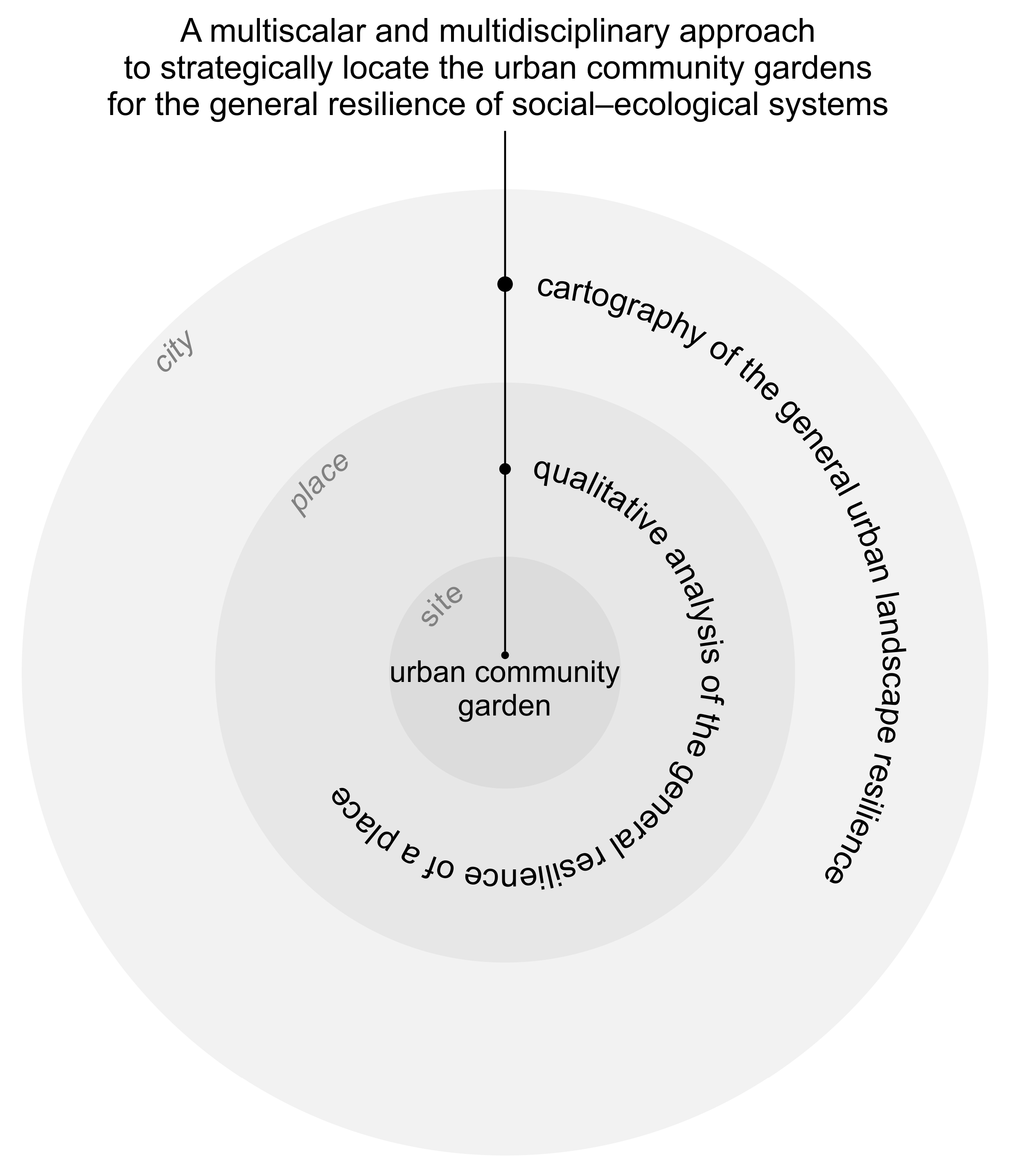
According to the panarchy principle, we suppose that a specific location of an urban community garden benefits not only the people within the garden but the whole city as well. The objective of this research is to postulate how strategically located urban community gardens enhance the general resilience of social–ecological systems on an urban scale through cartography and a qualitative analysis of five urban segments with community gardens in Queretaro, Mexico. A systemic methodology of the research helps to understand the interconnected relationships between different social and ecological systems on multiple scales.
Only with the emergence of urban community gardens do cities develop their general resilience due to the panarchy principle. Yet, it is spatially random, meaning that these resilient places may emerge where resilience is already relatively high, while the most vulnerable places stay the same. But if a strategic location is postulated as is possible, we can direct urban-community-garden networking to the resilience of social–ecological systems. So, cities are no longer a threat to ecosystems as the managing of natural resources embraces human and natural systems to adapt continually through synced cycles of change [
13].
In this paper, we explain the methods and materials used to apply the general resilience of a place and general urban-landscape resilience in case studies. We also include descriptions of these novel approaches to the general resilience of social–ecological systems through space. Then, the paper presents the results obtained from the qualitative analysis and the cartography of one of the five case studies. Through the intersected results of both methods, the explanation of the influence of the resilience of social–ecological systems on the urban scale follows. Finally, the paper concludes with a discussion of how these results can influence the future methodologies of urban planning and highlights the most important aspects to consider.
2. Materials and Methods
To postulate how strategically located urban community gardens enhance the general resilience of social–ecological systems on an urban scale, we need (1) to demonstrate how they enhance the general resilience of a single place, (2) to determine how they enhance the general resilience of a landscape, and (3) to explain how spatial changes in a single place influence the general resilience of social–ecological systems on an urban scale through its landscape.
To achieve these goals, we applied a systemic methodology combing a qualitative analysis on a local scale with a quantitative landscape analysis on an urban segment scale. Specifically, we applied a qualitative analysis of the general resilience of a place and an urban-landscape resilience cartography to five case studies in Queretaro (Mexico). In this paper, one of the five case studies—Mu’ta urban community garden—helps us to demonstrate the changes in the general resilience of the place where the garden has emerged through qualitative analysis, whilst its cartography on a larger scale shows the changes in the general resilience of the landscape with the emergence of the garden. The cartography of a landscape on a scale of an urban segment permits us to appreciate the changes triggered by the emergence of gardens, yet it also represents the landscape of Queretaro. Finally, we intersected the obtained results and highlighted the common ones in both approaches. The combined results from all five case studies can be found in
Appendix A and
Appendix B.
2.1. Qualitative Analysis to Comprehend the General Resilience of a Place
Cumming [
15], with his theory of spatial resilience, enlists the spatial variations that influence and are influenced by the resilience of social–ecological systems. These include the internal ones: (1) the spatial arrangement of system components and interactions, (2) the spatially relevant system properties, such as system size, shape, and the number and nature of system boundaries, (3) spatial variation in internal phases, and (4) the unique system properties that are a function of a location in space; and the external ones: (1) the spatial context, (2) connectivity, and (3) the resulting spatial dynamics or subsidies.
These general categories of spatial variations are one of the bases for our qualitative analysis method. They helped to categorize the description of spaces and to organize the patterns in relationships between spatial changes and changes in general resilience factors [
13]. Most of these spatial variations are general, but the function of a location in space is a unique property. In the documental analysis of the existing literature on urban community gardens, we discovered spatial variations of urban community gardens that increase or decrease all three general resilience factors: diversity, modularity, and the tightness of feedback. The categories of green spaces [
18,
25,
26], ecological learning [
27,
28,
29], ecosystem services [
30,
31,
32], common areas [
33,
34,
35], space appropriation [
36,
37,
38], and cultural symbols [
39,
40,
41] represent the unique properties of urban community gardens that enhance all three general resilience factors.
These categories relate to the concept of a place—a special connection between people and their environment. Through the processes of self-categorization, people and groups attribute to themselves the qualities of the environment as defining their identity [
42]. The place perspective is a qualitative way of understanding social–ecological systems spatially and, therefore, their spatial resilience. Place describes the identity of space as a social–ecological system [
15]. And, since all complex adaptive systems are assumed to have the capacity for general resilience [
13], the general resilience of a place is the capacity of a space to maintain its identity in the presence of any disturbance.
The appropriation of a place, by the people who live there, tightens feedbacks in social–ecological systems as people, who take ownership of the space they live in, generate social cohesion and help themselves to reduce crime, bring people together in a mutually beneficial union, and thus reduce dependence on government [
43]. Additionally, local knowledge suggests optimal practices for local ecosystems. Local ecosystem services directly decrease the vulnerability of the place [
12]. These spaces, along with instantly reducing market dependence, cultivate ecological knowledge, which serves each person individually, as well as future generations.
In addition, considering people are different and have different generalized experiences of their environment, how they identify with a place is different [
42]. Based on this vision, it is favorable to embrace the modularity of common areas: their diversification helps different social groups find their niche within the place. Different social groups, with different functions within a community, strengthen the diversity of the place and expand local knowledge when facing different adversities. Moreover, a place can reduce its vulnerability if it has diverse ecological practices. The green spaces of a place contribute to the modularity of a system through their diversification.
Ecological diversity is usually obtained in a practical way—creating large green spaces with different species, including flowering plants [
44], as well as promoting non-intensive care of them [
45]. However, the promotion of social diversity is a very delicate issue, as it can negatively affect social cohesion [
46]. Still, a certain openness to the rest of the city must be articulated.
We applied ethnographic interviews to the five urban community gardens of Queretaro: Micelio Urbano, Mu’ta, La Madriguera, Hercules, and Zona Viva. These are all urban community gardens that we could identify within the urban limits of Queretaro. The selection criteria were based on the definition of urban community gardens [
47,
48], concluding that they: (1) must be located within the urban area of Querétaro; (2) must have a relatively small cultivation area; (3) must grow nutritious crops, such as vegetables, legumes, and/or fruits; (4) must belong to a group of people; (5) must have decisions made by that group of people; and (6) must have knowledge that is shared with others. We selected only the urban segments with community gardens to normalize the results in the search for patterns.
The process of interviewing participants was carried out through the opinionated selection method [
49]. First, we interviewed the ones in communication, and then they directed us to the participants who possessed greater knowledge of the administration and the history of a garden. This tool helped us receive detailed descriptions of the spaces, where the gardens are located, the participants’ surroundings at the moment of the interviews, and how these spaces were before the interventions. Furthermore, we were able to observe the spaces and the interactions of their users ourselves.
Based on spatial variations proposed by Cumming [
15], we identified the present and past conditions in land use and cover, size, shape, limits, temporal variations, context, connectivity, and subsidies, and the unique properties: green spaces, ecological learning, ecosystem services, common areas, space appropriation, and meaning as a cultural symbol of gardens.
Also, as a place, a social–ecological system must count on diverse elements and a modular and tight feedback system to expand its adaptive capacity so as to absorb and overcome any disturbance. As such, we identified the changes in biodiversity, social diversity, the number and nature of social groups, and activities in nature to describe the changes in general resilience of a place caused by the emergence of urban community gardens. These categories allowed us to describe general resilience factors even if based on perception. Nevertheless, to improve the scientific validity of the ethnographic interviews, we triangulated the obtained data with observation and an online survey. We interpreted the relations between different spatial variations and general resilience factors to highlight the ones that increase resilience.
2.2. Cartography to Demonstrate General Urban-Landscape Resilience
According to the same theories of general and spatial resilience, landscape can be considered a social–ecological system as well. It also contains social and ecological elements that are united by functions in space. Likewise, the landscape is a complex adaptive system as it adapts to environmental conditions. Moreover, like any social–ecological system, the landscape has capacities for general resilience [
50].
In our previous paper [
50], we suggest that general landscape resilience is a function of spatial variations that allows a landscape to absorb and recover rapidly from any disturbance. Its elements and functions are expressed by land use and land cover. Land-use type represents the social interactions, land-cover–ecological interactions, and their overlap with specific activities in nature.
According to the classification system of land use in urban areas, as proposed by LaGro [
51], we considered the following uses: (1) residential, (2) commercial and services, (3) industrial, (4) transportation, communication, and utilities, (5) industrial and commercial complexes, and (6) mixed urban and built-up land uses. And cover types were classified according to the research of Vialle [
52], recognizing (1) urban forest, (2) urban agriculture, (3) horticulture, (4) constructed technosol, (5) green roof, (6) brownfield, (7) decantation pond, (8) paved technosol, and (9) sealed technosol land covers.
We reviewed the literature on how the optimum matrix of land-use and land-cover patches influences the diversity, modularity and tightness of feedback of a landscape [
53,
54,
55,
56]. However, we identified some contradictions: greater openness to engagement (heterogeneous landscape with open limits) is sought to increase diversity, and lower openness to engagement (homogeneous landscape with hard limits) is sought to develop tighter feedback. Nonetheless, these parameters can be balanced through modularity to achieve general resilience. Spatially, the modularity presents heterogeneity in the density of openness: some closed, homogeneous land use and cover patches between open and heterogeneous ones [
50].
Based on Santos [
57], we consider institutional land use (transportation, communication and utilities) as open to engagement, commercial (including services, industry and their complexes) as medium-open, and residential as closed to social engagement. Soil with vegetation or water (including urban forests, agriculture, horticulture, constructed technosols, and green roofs) is the most open land cover to ecological engagement, bare soil (brownfield and decantation pond) is medium, and sealed soil (paved and sealed technosols) is closed to ecological engagement [
52].
As mentioned before, the overlap of different land-use and land-cover openness types expresses different uses of natural resources. Single uses, especially commercial ones, decline the land quality since they create intensively cultivated irrigated areas [
58]. Ideally, there is an overall overlap between social and ecological land uses, especially if it is of a great variety. Depending on the land use, its ecological functions and species richness may vary. For instance, golf courses lack biodiversity, and their regular mowing and the significant use of agrochemicals contribute to fragmentation and habitat loss [
59]. Different plant species are related to these ecological functions, and this can be comprehended through the social–ecological overlap in urban landscapes [
50].
Furthermore, the possibility of social and ecological engagement in a landscape, for its diversity and modularity, can be described through spatial continuity [
50]. We specify that there is a need for social–spatial continuity, which permits walkability through an urban infrastructure, so people have a chance to engage socially. We consider that space is walkable when closed areas of residential use are not bigger than 12.56 ha (area of a circle with a diameter of 400 m as it is the distance that most people would walk [
60]). Ecological continuity describes the dispersion of different species through a landscape. Kirk et al. [
61] state that most species are able to disperse as long as the sealed soil area between different life support patches is not greater than 100 m.
Last but not least, the heterogeneity in the density of openness to engage is a general urban-landscape resilience principle that improves all three general resilience factors of a landscape [
50]. In this way, social cohesion (tightness of feedback) develops in large (but not larger than 12.56 ha) patches of residential land use, and diversity thrives in high-density open and medium-open land-use patches. On the contrary, greater biodiversity develops in large patches of vegetation, specifically those larger than 4.4 ha. It is an average threshold area describing a low level of diversity [
62]. On the other hand, small and dense patches of vegetation serve as a habitat for vulnerable species due to the absence of predators and fewer competitors [
63].
Cartography permits the operationalization of this approach. As usual, the elements of a landscape can be mapped. In this approach, we map the different levels of openness onto social engagement through different types of land use, and the different levels of ecological engagement through different types of land cover. From these two parameters, it is possible to realize processes to present social–ecological overlap, spatial continuity, and heterogeneity in the density of openness.
We suggest that overlaying different types of graphical presentations, such as solid patterns for social engagement and hatches for ecological engagement, is most adequate to present the social–ecological overlap [
50]. In such cartography, the percentage of vegetated land areas and the different land uses of these areas can be appreciated.
On the other hand, a presentation of spatial continuity requires more map processing. For instance, to present the social–spatial continuity, we used only the map of levels of openness to social engagement. Additionally, the sizes of closed patches needed to be calculated to identify those of 12.56 ha or bigger as fractures to social–spatial continuity. For ecological continuity, we used only the base cartography of levels of openness to ecological engagement. To appreciate the ecological continuity, areas further than 100 m from vegetated areas should be identified as fractures to ecological continuity [
50].
Finally, to present the heterogeneity in the density of openness, again, we used cartographies of levels of openness to social and ecological engagement separately. But for this principle, we applied a grid and interpolated its pixels [
50]. This technique allowed us to appreciate the difference in density through a landscape.
2.3. Scalar Intersection to Comprehend the General Resilience of Social–Ecological Systems Through Space
These two approaches form a dual comprehension of the general resilience of social–ecological systems through space. Each of them adapts to different scales and complements one other. The analysis of the general resilience of a place is most suited for the community scale, as it is possible to track mutual relationships between social and ecological elements. On this scale, relationships can still be comprehended at their finest complexity. The cartography of general urban-landscape resilience is more suitable for larger scales, even for an urban one. As the methodology is based on the dimensions relative to a block, the analysis limits should be larger than 12.56 ha to comprehend all the principles of general urban-landscape resilience in the landscape.
We suppose the influence of general resilience through scales because of the panarchy principle of social–ecological systems. Holling and Gunderson [
14] explained this phenomenon in “Panarchy: Understanding Transformations in Systems of Humans and Nature” as a structure in which systems are interlinked in continual adaptive cycles, which take place at different scales. Their theory suggests that researchers can identify the points at which a system is capable of accepting positive change and can use those leverage points to foster resilience and sustainability within the system.
To identify those leverage points interlinked through scales, we intersected the results from the qualitative analysis of the general resilience of a place with the ones from a cartography of general urban-landscape resilience. Specifically, we searched for the same principles of social–ecological overlap, spatial continuity, and heterogeneity in the density of openness to engage in the causal relationships between spatial variations and the general resilience factors of qualitative analysis. If the same principle is identified on the scale of a place, we consider that it is an interscalar leverage point for urban planning that seeks resilience.
2.4. Urban Community Gardens in Queretaro
There are several urban community gardens in Queretaro already. Nevertheless, these places are atypical of the local cultural background. It is an industry-oriented city in central Mexico, which had its biggest growth spurt during industrialization, in the second half of the 20th century. Spatial growth was related to the emergence of new national trade roads that crossed Queretaro. The ideology of progress and the need to integrate as quickly as possible into the global trade network, due to the stigma of postcolonialism [
57], led Queretaro to accelerated and uncontrolled growth. No urban-development plan is recorded that aimed to moderate the city’s growth but at its spatial adaptation. The goal of reducing traffic congestion resulted in the construction of increasingly wide roads, located further from the urban sprawl, which influenced the city’s fragmented growth [
64]. This caused great dispersion of the city and a tendency for people to use a car for everyday tasks.
The fields around the city have been occupied to meet the demand for housing, industrial, and recreational uses. These territorial manifestations have deepened social inequality and regional water-supply problems [
65]. Furthermore, with the abandonment of agriculture, food sovereignty in the region is becoming more complicated, and land suitable for cultivation is being wasted [
66].
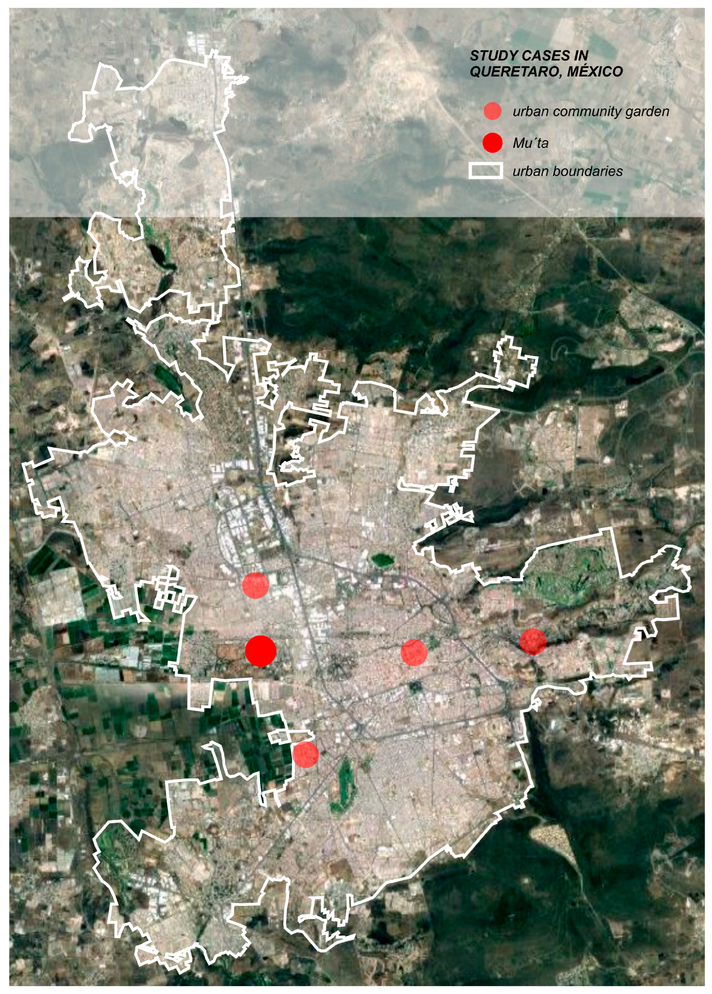
Instead, there are separate and small initiatives of urban and peri-urban agriculture. As we research the resilience of social–ecological systems on urban scales, we selected the five urban community gardens that are within the urban limits of Queretaro (
Figure 1). Their main features are presented in
Table 1.
Basically, the urban community gardens of Queretaro are small well-delimited spaces where fruits and vegetables are cultivated and ecological learning is offered. Most of them have required the citizens to appropriate abandoned spaces to create green common spaces and in this way change their symbolic meaning.
3. Results
We present the common results through a complete example of one of the five urban community gardens. Mu’ta is an urban community garden in the western area of the city, which presents all the common outcomes of the five cases.
3.1. Qualitative Analysis Results
During the ethnographic interviews, we found out about the contexts and history of five urban community gardens in Queretaro. La Madriguera is a university garden situated in the historic center of the city and it functions due to the learning goals. On the contrary, the garden located in the historic Hercules factory is based on a commercial exchange with the restaurant that currently occupies the site. And Micelio Urbano and Zona Viva, instead, seek more social engagement in the area.
Meanwhile, the garden of Mu’ta emerged in late 2019 when three agronomist friends, Liz, Karen, and Christian, decided to practice agriculture in an unused yard belonging to one of their grandfathers. The members had to clean the space and add a more nutritious substrate. About 63% of the space is dedicated exclusively to the garden, and the rest of it is for the work of generating substrates, seeds, storage, and events.
In fact, one of their main activities is the creation of organic substrates, which they sell to the public and they also offer courses about their production. In addition, the agronomists are dedicated to generating and selling organic seeds from the region and succulents. Even if the lack of a regulatory framework in Queretaro leads to experimentation in the trade and the storage of organic substrates, the gardeners of Mu’ta possess a great knowledge of agronomy and spread valuable knowledge through the courses they offer. These and other additional jobs help them maintain the garden. They divide the food from the garden between them and the grandfather, who occasionally helps them in the garden.
We observed that land use and land-cover change to an urban community garden increased social diversity and created new social groups within the place, as well as increasing its biodiversity and activities in nature. Furthermore, temporal variations changed from being always closed to sometimes open, enhancing the social diversity of the place. The context and the connectivity of the place did not affect resilience, while subsidies increased with the emergence of the garden. Finally, the unique properties of green space, ecological learning, and ecosystem services appeared to enhance biodiversity and activities in nature. A new common area, space appropriation, and its change as a cultural symbol made a place more socially diverse and created more social groups.
Interpreting the causes of the enhancement in the general resilience factors due to the changes in spatial variations, we conclude that an abandoned space gave a possibility to generate a new use of it. With the fact that new users are agronomists, the decision to create a garden there was taken. Having a garden in an urban yard involved changing the land cover to urban agriculture and the inclusion of a great variety of plant species. As the project includes a group of people, a gardening community has been formed. And the need for extra income to maintain the garden fostered the activities of courses and trade.
Summarizing the relationships between changes in spatial variations to create the garden and changes in general resilience factors through these changes, we observed that all general resilience values were increased by the generation of local ecosystem services. Also, the appropriation of the space by assigning it to the use of the garden helped develop the general resilience of unused space (
Figure 2).
Similar insights can be perceived in the overall qualitative analysis results of all of the study cases. They are presented in
Figure A1 of
Appendix A. All of them provide ecosystem services locally and create a common social space, but their involvement in ecological learning varies. As mentioned before, La Madriguera is based on ecological learning activities, while Mu’ta and Zona Viva conduct courses to collect money to maintain the garden, and Micelio Urbano and Hercules function only as social initiatives.
In addition, all cases have generated new common areas and green spaces (except Micelio Urbano, and Zona Viva) in order to have gardens in those locations. However, the most interesting difference is that Zona Viva was a completely open public space, while others belonged to someone, but the decision to appropriate the space and establish entrance rules or the partial openness in certain hours of already appropriated spaces resulted in the same outcome—more social diversity and social groups.
3.2. Cartography Analysis Results
The neighborhood of Mu’ta is surrounded by a military camp from the south, southwest, and west, and railroad tracks run through the northern part of it. There is a large urban void within the military camp, while the rest of the area is densely built up. More specifically, the urban segment around Mu’ta is dense and has a low level of economic activity and social interactions.
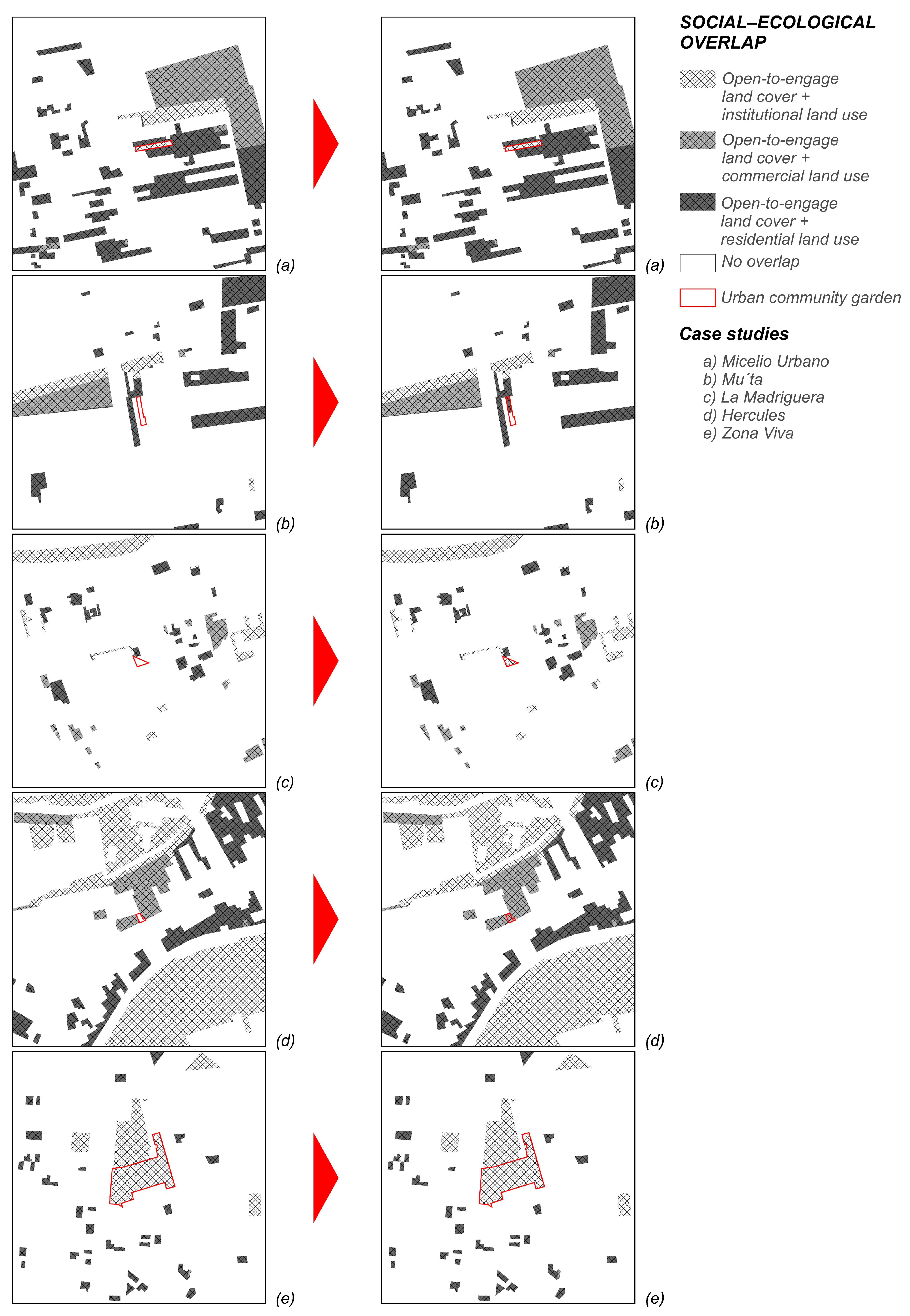
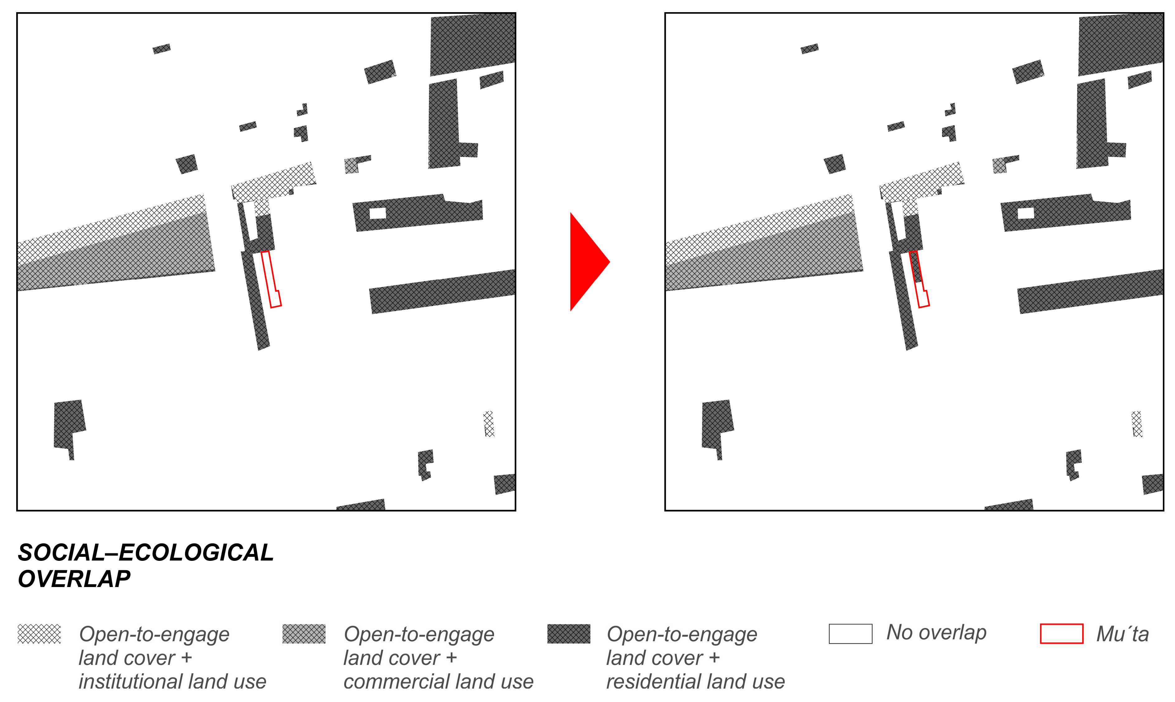
Yet, from the general urban-landscape resilience perspective, the place where Mu’ta is located opened social and ecological engagement at all levels with the construction of the garden: the place went from being closed to medium-open to social engagement, and from sealed soil it became a soil open to ecological engagement. The overall social–ecological overlap of an urban segment with Mu’ta is 14%; 2.24% of it is for institutional use, 3.78% is for commercial use, and 7.98% is for residential use (
Figure 3).
As observed in the overall results, very little space in Queretaro is covered by vegetation or water; in most cases, it is around 15%. Although the overlap is observed in different types of land use, the variation in their percentages is very low. Mainly, green spaces are promoted in residential areas (as in the case of Mu’ta) or in public spaces. The overall results of social–ecological changes can be found in
Figure A2 of
Appendix B.
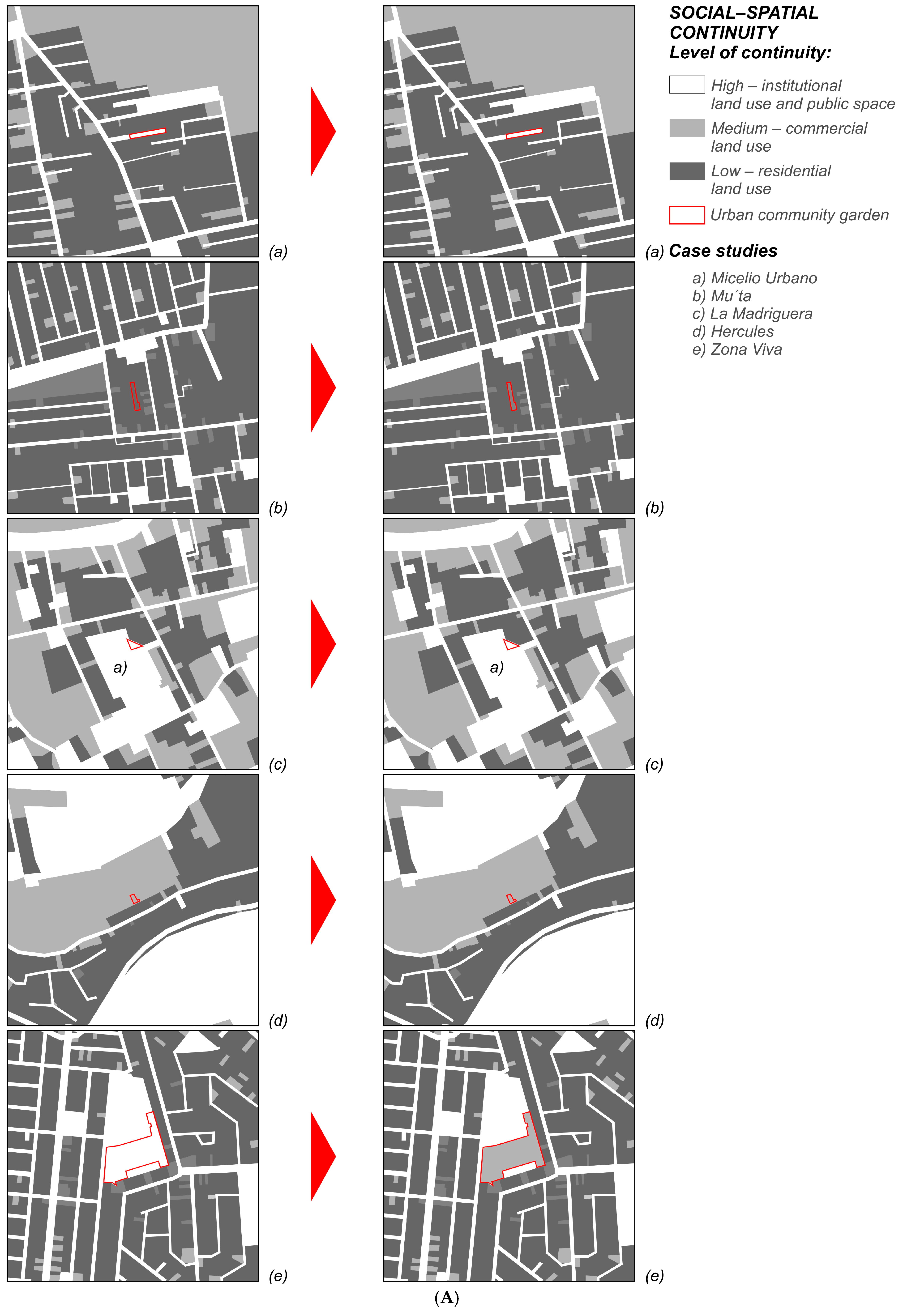
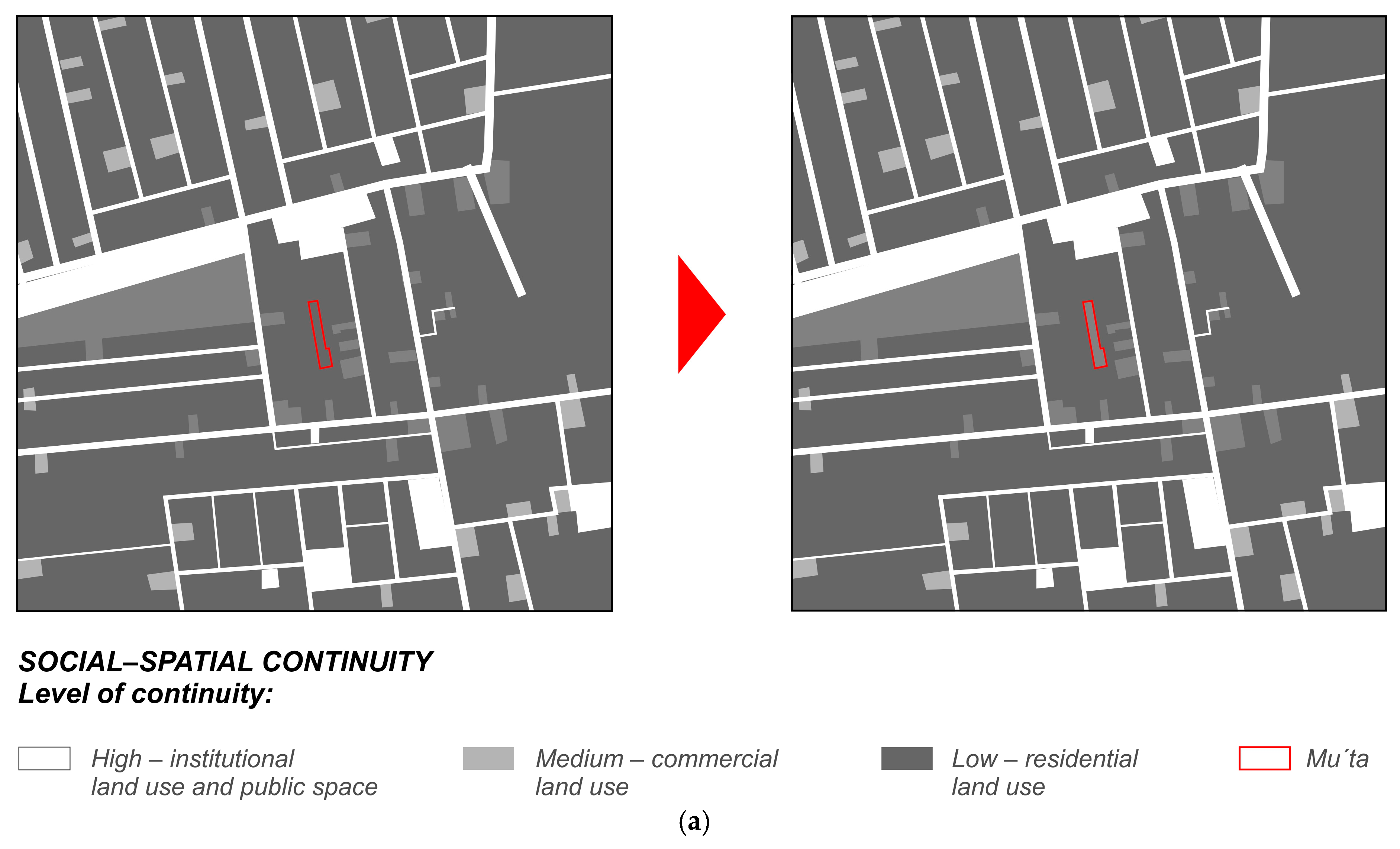
Regarding the cartography of social–spatial continuity, the results show that, although residential use is predominant in Queretaro, in no case study are the enclosed areas too large to fracture the social space. However, upon reviewing the land cover, we identified a lack of ecological continuity. Cases such as an urban segment with Mu’ta would need a strong landscape intervention to enhance its ecological continuity (the results of spatial continuity changes in all five case studies are presented in
Figure A3 of
Appendix B).
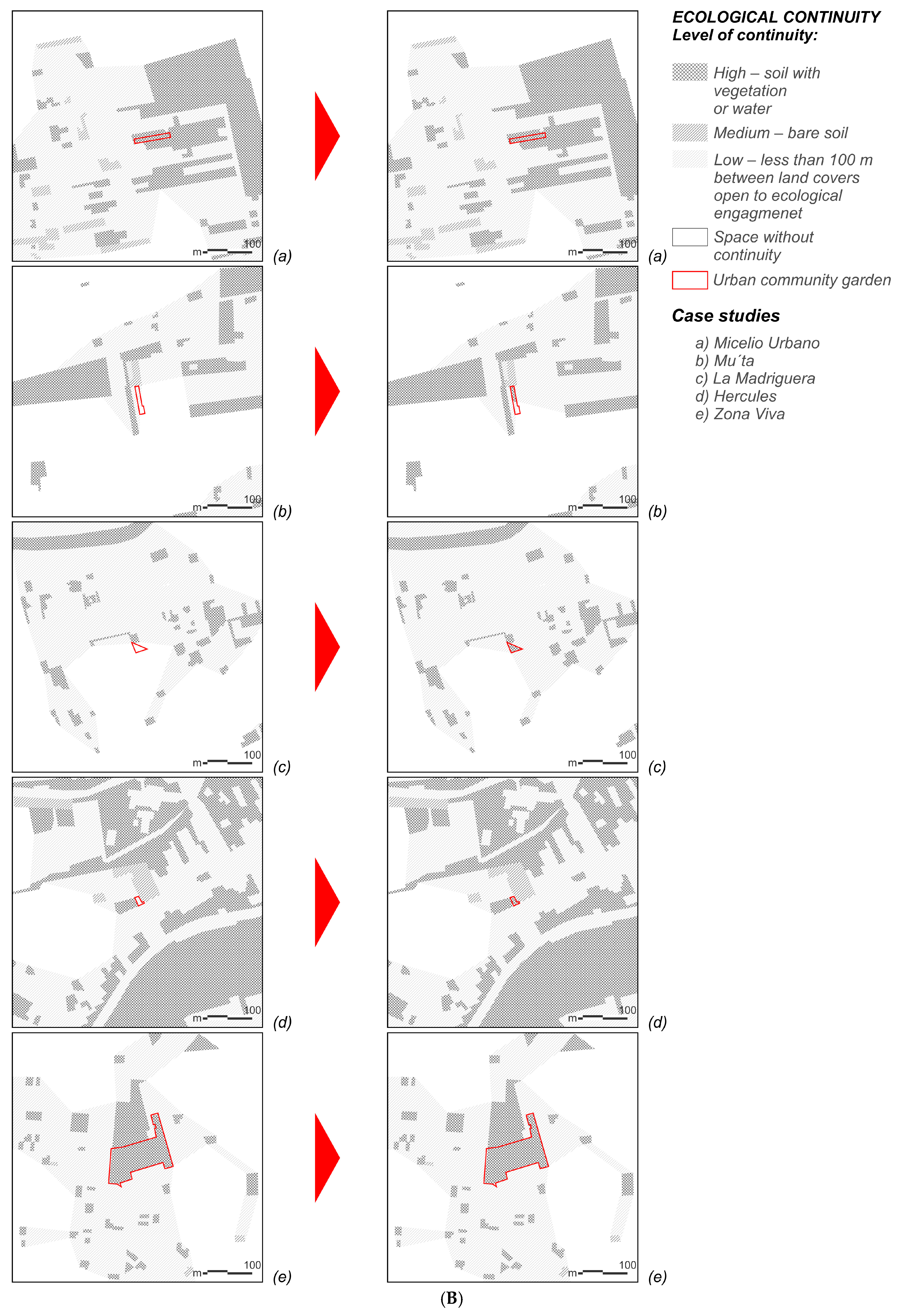
Yet, we perceived the influence of the urban community garden of Mu’ta as providing a stepping-stone for biodiversity in the urban segment and as promoting ecological continuity (
Figure 4). Other case studies also function as stepping-stones in the landscape of Queretaro as all of them are basically vegetated land cover. Just Zona Viva possesses a significantly larger garden space, which, in combination with other green areas, may create a core area for a natural habitat in the city.
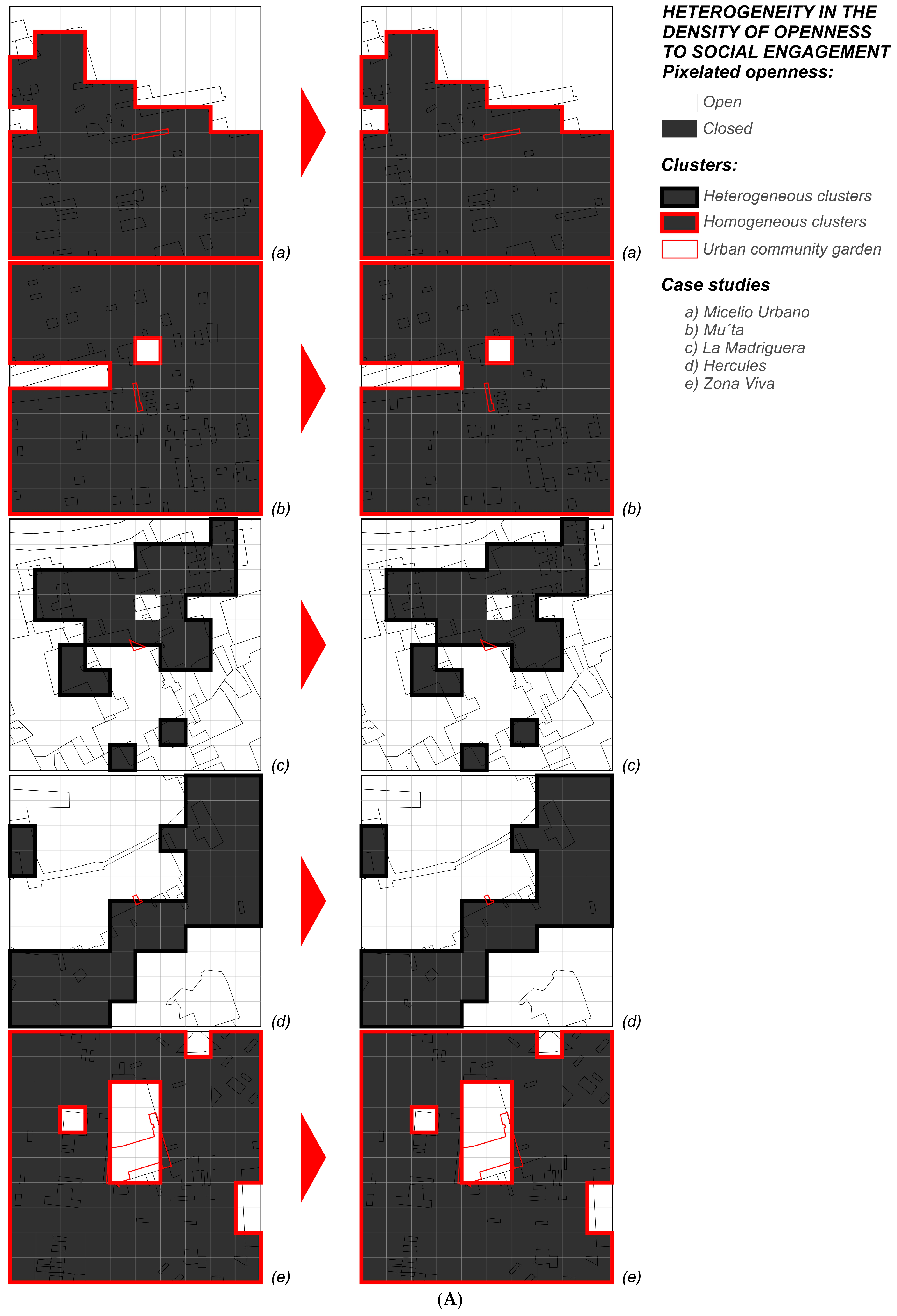
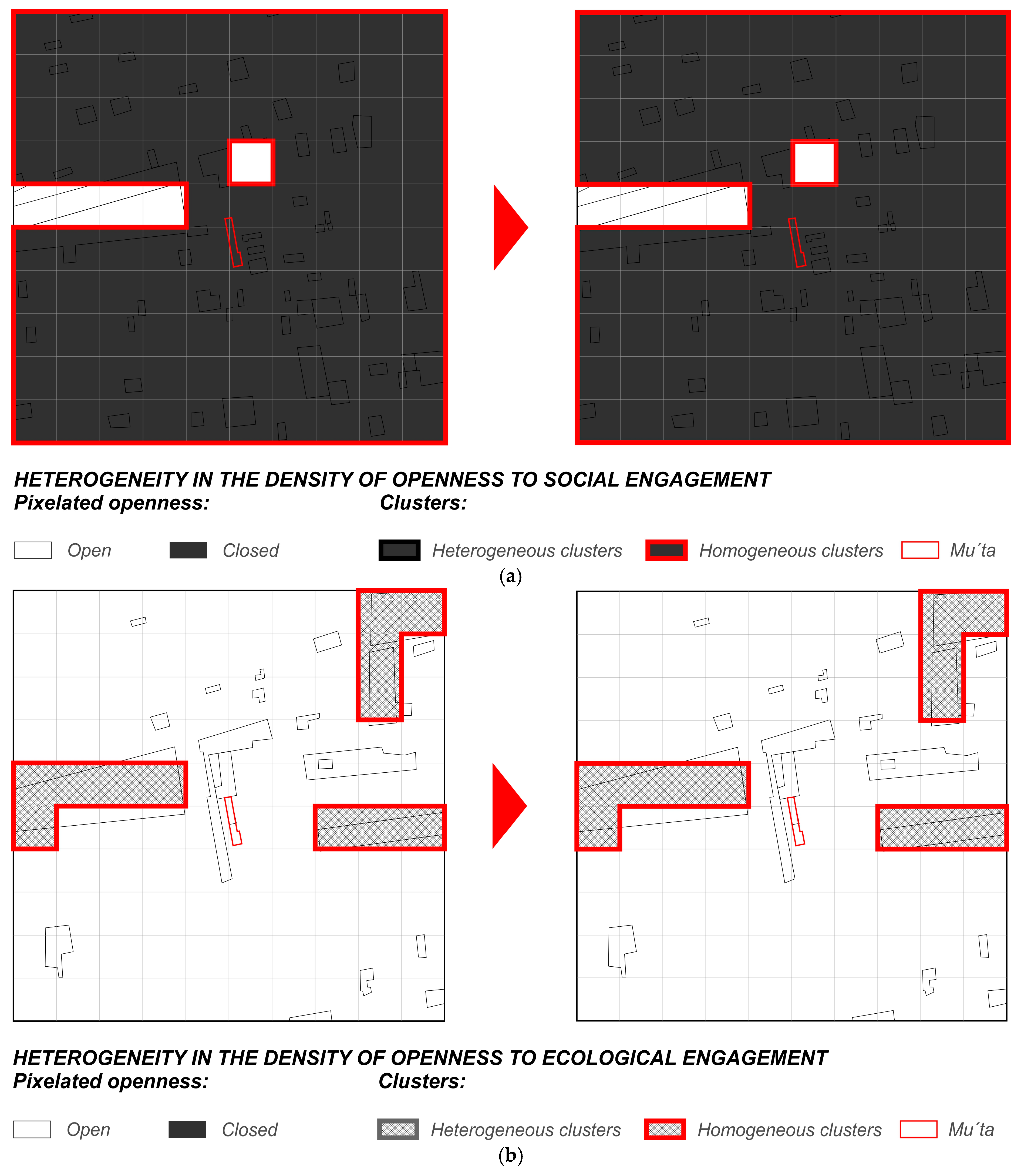
On the other hand, the percentage of closed areas to social engagement in the place with Mu’ta is 95%, with a variability in group sizes of one patch of 23.75 ha (
Figure 5). This demonstrates the extreme homogeneity in the density of social openness of a landscape. Also, in this cartography, we perceive that the small size of the urban community gardens of Queretaro does not influence the density. Furthermore, the percentage of open areas to ecological engagement in Mu’ta is 12%, with the variability in cluster sizes of three patches of 1 ha (
Figure 5). This presents homogeneity in the density of openness to ecological engagement as well. Moreover, the general results of the changes in the heterogeneity in terms of the density of openness to engage can be looked up in
Figure A4 of
Appendix B.
3.3. Intersected Results
When the results from both approaches were complete, we intersected them due to the causal relations between the changes in spatial variations and their influence on general resilience to identify patterns between these different approaches and their proximity scales. Specifically, we searched for principles of social–ecological overlap, spatial continuity, and heterogeneity in density of openness to engage in causal relations of qualitative research to establish the existence of the same principles on different scales and different approaches. The most significant intersected results are presented in
Table 2.
All five urban community gardens contribute to the general resilience of the social–ecological systems of the city through the generation of ecosystem services locally, creating common and green spaces within the city, and by spreading ecological knowledge to its citizens. Particularly, Mu’ta enhances this through continuous involvement in different social groups for diverse activities. Micelio Urbano also enhances the general resilience of the city while involving communal and circular economy schools of thought. La Madriguera specializes in shaping the knowledge of the ecology of young adults and providing green spaces in the historic center of Queretaro. Hercules is distinct in the development of resilience through the spreading culture of gardening in one of the most popular places of Queretaro. And Zona Viva is highly distinctive because of cultural gatherings which involve inhabitants from all over the city.
In general, the ethnographic interviews revealed that the general resilience of a place is enhanced when appropriating an abandoned space to create an urban community garden there and giving this type of cultural symbol to a place. On the scale of a place, a socio-ecological overlap figures as local ecosystem services and ecological learning. In a qualitative manner, different types of activities in different green spaces describe the diversity of use of the natural resources of a place.
Also, spatial continuity can be perceived on a scale of a place. The physical boundaries, such as walls and fences, delimit the social–spatial continuity of a place. On the contrary, the creation of common spaces enhances it. Additionally, green spaces contribute to ecological continuity by creating core areas for natural habitats or at least stepping-stone patches. On this scale, ecological continuity can be studied by averaging the patch-specific continuities across all habitat patches of the place [
68].
Furthermore, the results of the qualitative analysis show the dialectical relationship between openness and closeness, just as presented by general urban-landscape resilience. On the scale of a place, we perceived that neither too open a space nor too closed a space enhances the general resilience of a place compared to a combined one. This type of limit describes the heterogeneity in density through the balance created between the isolation of a place and its connection to the outside [
54].
But the main variety in the openness was temporal. The owners of each place establish their schedule and whether and when to organize events of socio-ecological exchange. On the scale of the urban segment, these results confirm the panarchy of the concept of resilience and show its relationship with heterogeneity in terms of the density of openness to social engagement.
Yet, heterogeneity in the density of ecological openness is not perceived in the qualitative analysis of a place. Basically, this is due to the specific quantification of natural habitat patches. Nevertheless, we can relate it to the sizes and distances between green spaces within a place.
The identification of the principles of general urban-landscape resilience in a qualitative analysis of a place supports the interlinked spatial points between different scales of social–ecological systems. These leverage points are the spatial variations of urban community gardens that influence the development of the general resilience of the social–ecological systems of a city.
4. Discussion
The intersected results indicate the scalar connection of social–ecological overlap, spatial continuity and heterogeneity in the density of openness to engage. Thus, by balancing private and public land use, creating common areas and green spaces, and generating ecological learning and ecosystem services locally, the raised principles improve and enhance the general resilience of a landscape as well. Hence, these principles may stand out as universal spatial variations that influence the general resilience of social–ecological systems at any scale.
They can be incorporated into urban planning when seeking the general resilience of a city because they provide operational features. For instance, the social–ecological overlap of different land uses, which include vegetation, describes its diversity. The overall overlap demonstrates the level of biodiversity within the space, and the different uses of those spaces–the diversity of ecosystem services. Yet, this analysis can be carried out with elementary data on land use and land cover.
Moreover, spatial continuity provides more operational methods to the already well-studied concept of continuity. It offers a new approach that allows spatial continuity analysis of large scale [
69,
70]. And the heterogeneity in the density of openness to engage is a new concept, which allows us to describe the modularity of a space at any scale. In this case, the interpolation method gets a new use [
71].
After all, the principles of social–ecological overlap, spatial continuity, and heterogeneity in the density of openness to engage expand the comprehension of the resilience of cities. The approach to urban resilience through its landscape encourages urban systems to reorganize in response to disturbances. In a complex and constantly changing environment, the landscape operates as a medium for urban processes, capable of responding to transformation and adaptation [
72]. This takes place from an urban-planning perspective, based on the understanding of spatial interactions in which organisms and flows participate in a landscape [
7]. The built landscape is the response to human possibilities [
4], while the specific mechanisms of the ecological landscape to respond to environmental change and to adapt to transitions are seen through successional stages. Large natural habitat areas have a large internal memory and are more capable of recovering, while small patches, common in urban landscapes, depend more on external memory and often develop into something new [
1].
As urban community gardens contain the mentioned spatial variations by their very nature, they trigger the spatiotemporal distribution of human actions oriented to the general resilience of social–ecological systems. Together with their strategic location, they help to guide environmental attitudes within the most vulnerable urban segments of a city. Case studies have revealed that new social groups were created, and various citizens became interested in ecology and gardening when they discovered these places (
Figure A1 of
Appendix A).
Such activities work not only to increase biodiversity, produce goods, and learn about the environment but also to sensibilize urban inhabitants to natural life cycles. The negative tendencies towards certain species are driven by cultural and empirical influences, which can be oriented in different directions by spaces such as gardens [
73]. Jointly, ecological continuity expands through the landscape with the emergence of gardens (
Figure A3 of
Appendix B).
In sum, urban resilience increases when mental attitudes are towards community and ecology [
74]. Local benefits increase as well by creating common and green areas so the community may appropriate these spaces for productivity and thus reduce their vulnerability [
2]. Furthermore, the social cohesion generated by these spaces is an important element of well-being. Even if these spaces do not correspond to all the instant needs of a community, their benefits work for the long-term [
75].
As the study demonstrates the functionality of place-based actions to approach resilience in cities, the perspectives of a place and a landscape can be integrated to create a multiscalar and multidisciplinary methodology. This methodology may consist of various stages. Firstly, a specific place of intervention can be selected based on the cartography of the general urban-landscape resilience. Areas which lack social–ecological overlap, spatial continuity, and heterogeneity in the density of openness to engage are the indicated places for the development of urban community gardens. However, community involvement is the most challenging part [
76]. We suggest approaching this through gardening courses first. With a certain interest of local inhabitants, it is possible to carry out the qualitative analysis of their place, the planning, and the construction of an urban community garden.
Preferably, the government should be included in the process to facilitate the occupation of the site and the access to theoretical, technical, and practical tools for the development of a garden [
21]. This type of methodology unites different urban actors to capture their collective expertise and perspectives and accommodates future developments and changes for the multifaceted nature of cities [
77].
A methodology of urban planning can be created and guided by this case study (
Figure 6). We suggest the possibility of generating cartographies of the general urban-landscape resilience of cities to identify spaces that lack it. Moreover, based on this analysis, we can interpret the land size and its use and cover needed in these particular places.
Since top-down approaches to specific places typically fail [
78], to modify them according to the general urban-landscape resilience cartography, the community of the place should be included in decision-making. Locals should be included in the analysis of the general resilience of the place so as to comprehend their needs and select the site for a garden. Also, the design process of a garden, its construction, and its care are mostly dependent on the local community. A qualitative analysis of the general resilience of a place should be applied to highlight the more specific needs of a place. A participative design of urban community gardens would help to create space for the complex needs of a community, while including spatial parameters needed for the general resilience of social–ecological systems.
Yet, this theoretical and methodological approach is exploratory and only suggests the possibility of its generalization. The topic of resilience is complex, and even ongoing research presents uncertainties. In this case, the research shows some small advances in the subject, while the study suggests that the integration of both core methods in urban planning would help to create resilient places for communities and a resilient landscape of a city.
For future research, we recommend the application of the methodology in different urban contexts and testing the proposed urban planning methodology in real-life scenarios in Queretaro. The first attempt could be by selecting one of the places lacking general urban-landscape resilience and creating an urban community garden there with the local community. This attempt may demonstrate social involvement in urban agriculture and the possibility of governmental and local collaboration.
5. Conclusions
As cities grow larger, their footprint in ecosystems increases. The larger the footprint, the greater the reliance of a city on external production and absorption, and the less resilient it becomes to sudden changes in supply and demand of an urban system. Urban community gardens are places within cities to provide provisioning supplies. In this paper, we have postulated how urban community gardens increase the general resilience of social–ecological systems on multiple scales, have demonstrated the linkage between different scales in terms of the general resilience of social–ecological systems in the urban environment, have provided operational principles to its approach in analysis, and have suggested a methodology of urban planning when developing the general resilience of social–ecological systems on multiple scales.
The case studies of urban segments with community gardens in Queretaro demonstrate that the general resilience of these places increased due to their emergence. Mu’ta urban community garden created a green area and a trade point in an abandoned yard. Micelio Urbano is now a city-wide community, which fosters urban community gardening, La Madriguera provides a natural environment oasis in the historic center, Hercules sensibilizes inhabitants from all the city with regard to gardening practices, and Zona Viva changed the perception of a dangerous place to one of peace.
Furthermore, the cartography of the segments demonstrated a minor increase in the general urban-landscape resilience as well. So, the influence of those small gardens is reflecting on a larger scale already. The most evident change is regarding the expansion of ecological continuity within the city through the urban community gardens of Mu’ta, La Madriguera, and Hercules.
We identified the same principles on different scales and in different spatial approaches to the general resilience of social–ecological systems. As a landscape is a limitless medium and its general resilience is an asymmetric open–close relation pattern, urban community gardens enhance the general resilience of a landscape at any scale. On the urban scale, it means the resilience development in one place within the urban tissue. This positive change fosters resilience within the social–ecological system of a city.
In this research, the interscalar leverage points were discovered when applying the methodology, and future studies should modify the qualitative analysis aligned with the proposed principles before its implementation. Also, there might be a greater variety in causal relations of qualitative results if a city has more urban community gardens. This may generate alterations in the final results. A study, which includes urban segments of places both with and without urban community gardens, may collaborate in the adjustment of the research as well. Therefore, such future studies are necessary to verify the proposed principles and to modify or expand them if it is the case.
Meanwhile, by demonstrating that urban community gardens enhance the general resilience of social–ecological systems on the urban scale, we suggest the possibility of strategical development of urban community gardens to improve social involvement towards the general resilience of social–ecological systems on an urban scale. Government and urbanists should include these outcomes when seeking the resilience of cities. They need to connect local initiatives with urban planning so that resilient practices can be implemented strategically. Not only are local communities able to follow the pre-established objectives, but also policymakers and academics can learn from those practices to create resilient places and enhance the resilience of social–ecological systems at different scales.


