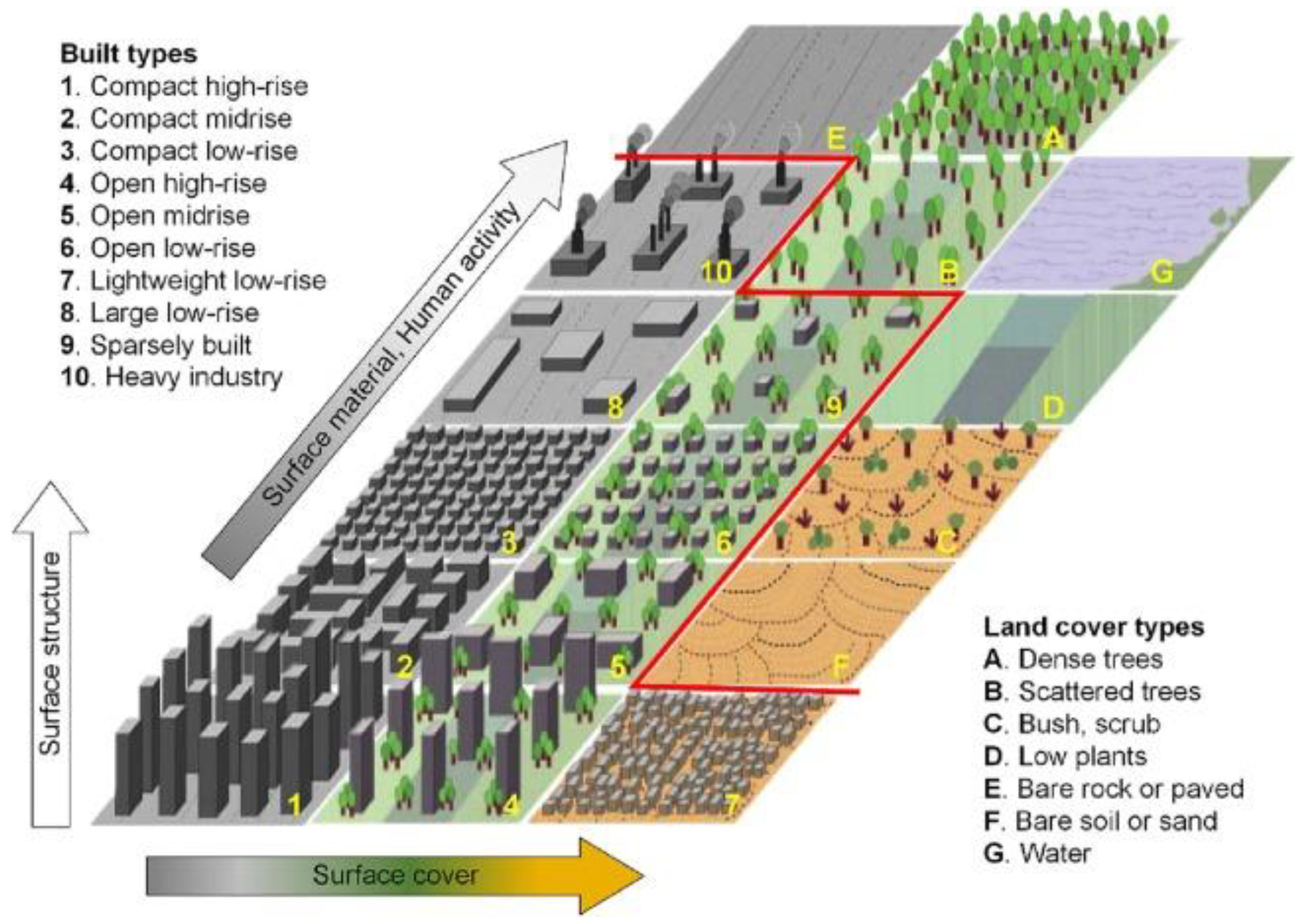
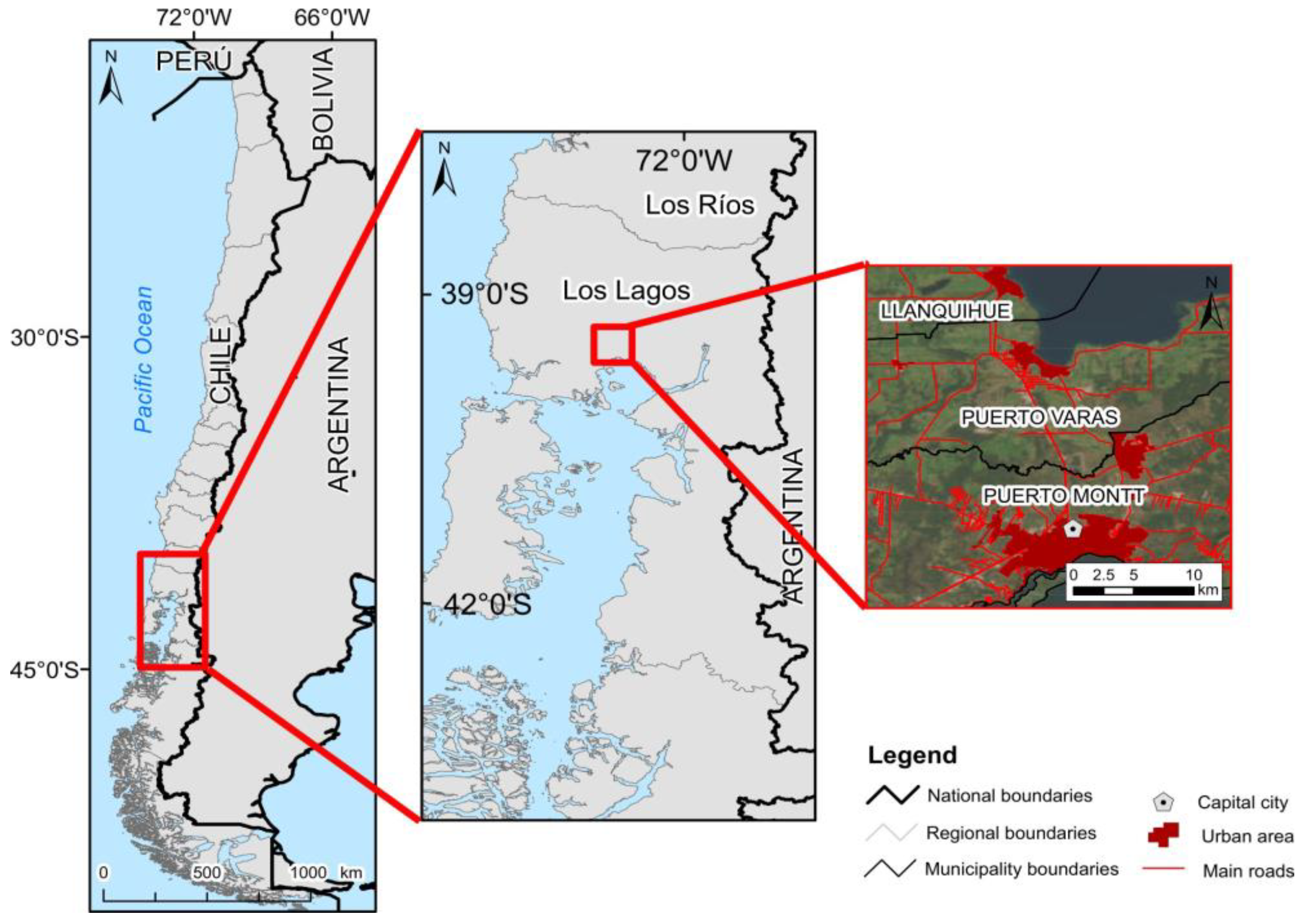
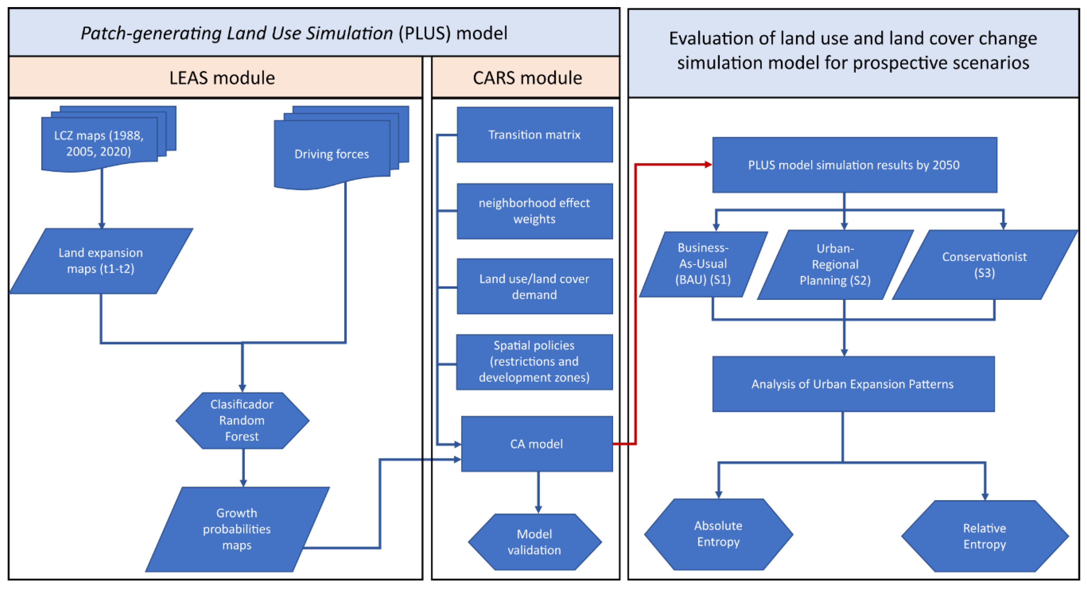
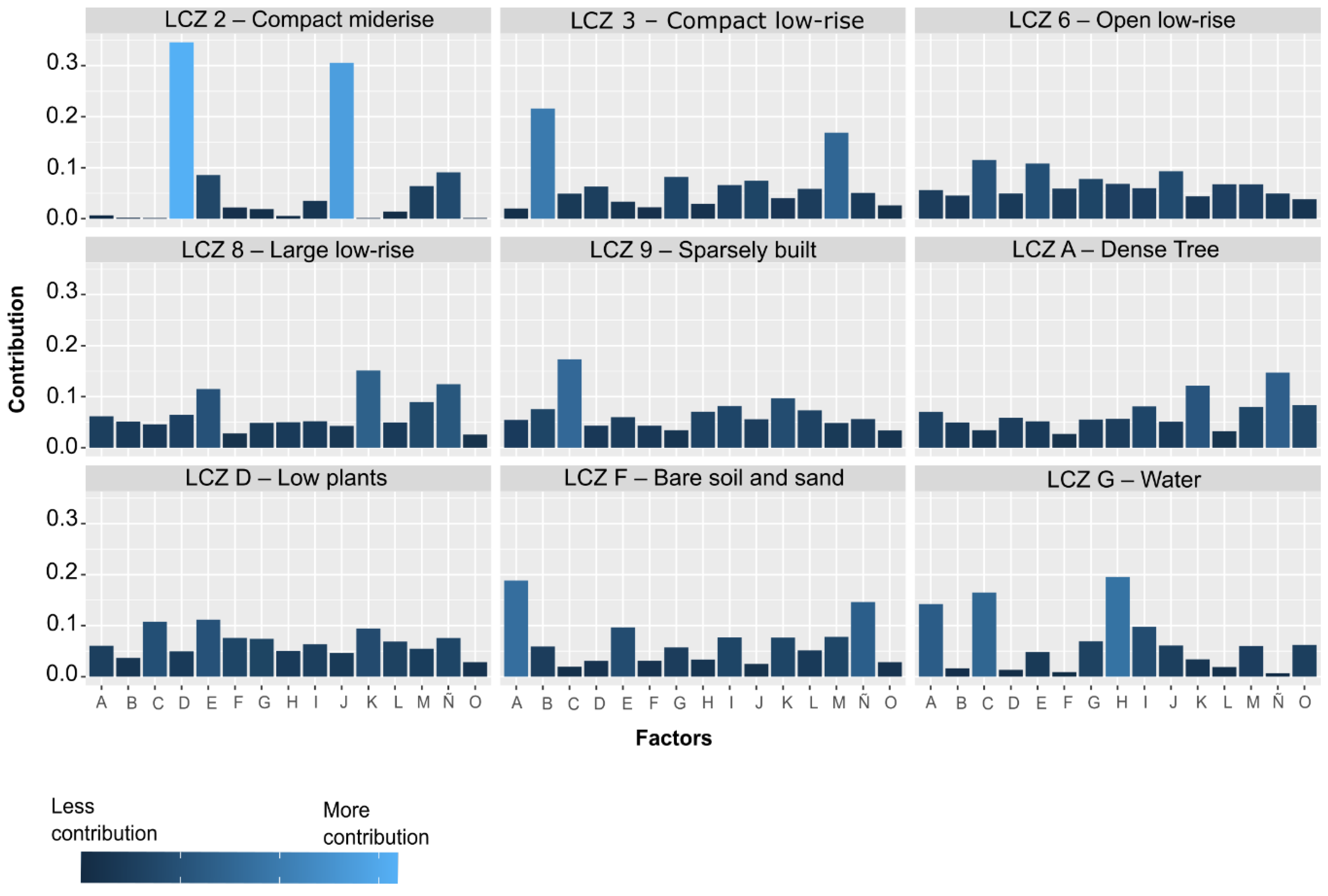
Formulation of Urban Growth Scenarios for Middle-Sized Cities Towards Metropolization: The Case of Puerto Montt, Los Lagos Region
Abstract
1. Introduction
2. Background
3. Materials and Methods
3.1. Study Area
3.2. Data Collection
3.3. Data Analysis
3.3.1. Image Processing
3.3.2. PLUS Model Framework
3.3.3. Application of the PLUS Model and Scenario Definition
3.3.4. Analysis of Urban Growth Patterns
3.3.5. Model Validation
4. Results
4.1. LCZs Trajectories Between 1988 and 2020
4.1.1. 1988–2005
4.1.2. 2005–2020
4.2. Simulation of Urban Expansion of Puerto Montt to 2050
4.2.1. Land Expansion Analysis Strategy (LEAS)
4.2.2. Business-As-Usual (BAU) Scenario Simulation
4.2.3. Urban-Regional Planning Scenario Simulation
4.2.4. Conservationist Scenario Simulation
4.3. Validation of the Results Obtained by Simulation
4.4. Analysis of Urban Expansion Patterns Simulated by 2050
5. Discussion
5.1. Current and Future Dynamics of the Urban Expansion Simulation
5.2. Potential Impacts of the Predicted LULC Changes
5.3. Diversity of Selected Scenarios by 2050
5.4. Limitations and Future Areas of Research
6. Conclusions
Author Contributions
Funding
Data Availability Statement
Conflicts of Interest
References
- Glaeser, E. Triumph of the City; Pan Books: London, UK, 2012. [Google Scholar]
- UN-Habitat III Declaración De Quito Sobre Ciudades Y Asentamientos Humanos Sostenibles Para Todos, Borrador De Septiembre 10 De 2016. 2016, p. 35. Available online: https://habitat3.org/wp-content/uploads/NUA-Spanish.pdf (accessed on 1 November 2024).
- Henríquez, C. Modelando El Crecimiento de Ciudades Medias. Hacia Un Desarrollo Urbano Sustentable; Ediciones Universidad Católica de Chile: Santiago de Chile, Chile, 2014. [Google Scholar]
- Nilsson, K.; Pauleit, S.; Bell, S.; Aalbers, C.; Nielsen, T.S. Peri-Urban Futures: Scenarios and Models for Land Use Change in Europe; Springer Publication: Berlin/Heidelberg, Germany, 2013; ISBN 978-3-642-30529-0. [Google Scholar]
- Echeverría, C.; Newton, A.C.; Lara, A.; Benayas, J.M.R.; Coomes, D.A. Impacts of Forest Fragmentation on Species Composition and Forest Structure in the Temperate Landscape of Southern Chile. Glob. Ecol. Biogeogr. 2007, 16, 426–439. [Google Scholar] [CrossRef]
- Williams, B.; Shahumyan, H.; Boyle, I.; Convery, S.; White, R. Utilizing an Urban-Regional Model (MOLAND) for Testing the Planning and Provision of Wastewater Treatment Capacity in the Dublin Region 2006–2026. Plan. Pract. Res. 2012, 27, 227–248. [Google Scholar] [CrossRef]
- Henríquez, C.; Morales, M.; Qüense, J.; Hidalgo, R. Future Land Use Conflicts: Comparing Spatial Scenarios for Urban-Regional Planning. Environ. Plan. B Urban Anal. City Sci. 2023, 50, 332–349. [Google Scholar] [CrossRef]
- Sleeter, B.M.; Sohl, T.L.; Bouchard, M.A.; Reker, R.R.; Soulard, C.E.; Acevedo, W.; Griffith, G.E.; Sleeter, R.R.; Auch, R.F.; Sayler, K.L.; et al. Scenarios of Land Use and Land Cover Change in the Conterminous United States: Utilizing the Special Report on Emission Scenarios at Ecoregional Scales. Glob. Environ. Change 2012, 22, 896–914. [Google Scholar] [CrossRef]
- IPCC. Special Report on Emissions Scenarios; Cambridge University Press: Cambridge, UK, 2000; p. 570. [Google Scholar]
- OECD. The Governance of Land Use in OECD Countries: Policy Analysis and Recommendations; OECD Publishing: Paris, France, 2017; ISBN 978-92-64-26878-4. [Google Scholar]
- Cebrián, F.; Sánchez, I. Urban Sprawl in Inner Medium-Sized Cities: The Behaviour in Some Spanish Cases Since the Beginning of the 21st Century. Urban Sci. 2019, 3, 10. [Google Scholar] [CrossRef]
- Maturana, F.; Morales, M.; Peña-Cortés, F.; Peña, M.A.; Vielma, C. Urban Growth, Real Estate Development and Indigenous Property: Simulating the Expansion Process in the City of Temuco, Chile. ISPRS Int. J. Geo-Inf. 2021, 10, 101. [Google Scholar] [CrossRef]
- Morales, M.; Maturana, F. Analysis of Spatial Patterns in the Urban Expansion of Middle-Sized Cities. The Case of San Fernando, Chile. Cuad. Vivienda Urban. 2019, 12. [Google Scholar] [CrossRef]
- Salazar, A.; Baldi, G.; Hirota, M.; Syktus, J.; McAlpine, C. Land Use and Land Cover Change Impacts on the Regional Climate of Non-Amazonian South America: A Review. Glob. Planet. Change 2015, 128, 103–119. [Google Scholar] [CrossRef]
- Borsdorf, A. Cómo Modelar El Desarrollo y La Dinámica de La Ciudad Latinoamericana. Eure 2003, 29, 37–49. [Google Scholar] [CrossRef]
- Zunino, H.; Hidalgo, R. Las Políticas de Vivienda En El Chile Neoliberal: Efectos Socioespaciales y Relaciones de Poder En El Caso Del Área Metropolitana de Valparaíso y Su Periferia. In Chile: Del País Urbano al País Metropolitano; Pontificia Universidad Católica de Chile: Santiago, Chile, 2009; p. 469. [Google Scholar]
- Allard, P.; Correa, J.I.; Sánchez, J.F. Parcelaciones Rurales: Propuestas Para El Desarrollo de Las Subdivisiones Rústicas En Chile; Centro de Estudios Públicos: Santiago, Chile, 2022. [Google Scholar]
- Instituto Nacional de Estadísticas. Censo de Vivienda y Población 2017; Gobierno de Chile: Santiago, Chile, 2017. [Google Scholar]
- Henríquez, C.; Pontius, R.G.; Contreras, P. Performance of CA_Markov and DINAMICA EGO Models to Evaluate Urban Risk in Antofagasta and Mejillones, Chile. Nat. Hazards 2024, 120, 8411–8435. [Google Scholar] [CrossRef]
- Mustelier, D.; Henríquez, C. Modeling Land Use Change of Mid-Sized Cities in the Process of Metropolization. Case Study La Serena-Coquimbo Conurbation, Chile. Geogr. Environ. Sustain. 2024, 17, 106–118. [Google Scholar] [CrossRef]
- Herrera-Benavides, J.; Pfeiffer, M.; Galleguillos, M. Land Subdivision in the Law’s Shadow: Unraveling the Drivers and Spatial Patterns of Land Subdivision with Geospatial Analysis and Machine Learning Techniques in Complex Landscapes. Landsc. Urban Plan. 2024, 249, 105106. [Google Scholar] [CrossRef]
- Ubilla-Bravo, G.F. A Geospatial Model of Periurbanization—The Case of Three Intermediate-Sized and Subregional Cities in Chile. Land 2024, 13, 694. [Google Scholar] [CrossRef]
- Aguila, M.J.; Prada, J. Crecimiento Urbano y Segregación Socioespacial En Valdivia. Rev. Urbano 2020, 23, 32–43. [Google Scholar] [CrossRef]
- Asubonteng, K.; Pfeffer, K.; Ros-Tonen, M.A.F.; Baud, I.; Benefoh, D.T. Integration versus Segregation: Structural Dynamics of a Smallholder-Dominated Mosaic Landscape under Tree-Crop Expansion in Ghana. Appl. Geogr. 2020, 118, 102201. [Google Scholar] [CrossRef]
- Del Pozo, A.; Catenacci-Aguilera, G.; Acosta-Gallo, B. Consequences of Land Use Changes on Native Forest and Agricultural Areas in Central-Southern Chile during the Last Fifty Years. Land 2024, 13, 610. [Google Scholar] [CrossRef]
- Abass, K.; Ko, S.; Agyemang, S. Peri-Urbanisation and Loss of Arable Land in Kumasi Metropolis in Three Decades: Evidence from Remote Sensing Image Analysis. Land Use Policy 2018, 72, 470–479. [Google Scholar] [CrossRef]
- Batty, M. The New Science of Cities; Massachusetts Institute of Technology: Cambridge, MA, USA, 2013. [Google Scholar]
- Batty, M.; Karmeshu, A. Strategy for Generating and Testing Models of Migration and Urban Growth. Reg. Stud. 1983, 17, 223–236. [Google Scholar] [CrossRef]
- Chen, M.; Samat, N.; Maghsoodi Tilaki, M.J.; Duan, L. Land Use/Cover Change Simulation Research: A System Literature Review Based on Bibliometric Analyses. Ecol. Indic. 2025, 170, 112991. [Google Scholar] [CrossRef]
- Wang, J.; Bretz, M.; Dewan, M.A.A.; Delavar, M.A. Machine Learning in Modelling Land-Use and Land Cover-Change (LULCC): Current Status, Challenges and Prospects. Sci. Total Environ. 2022, 822, 153559. [Google Scholar] [CrossRef]
- Gao, L.; Tao, F.; Liu, R.; Wang, Z.; Leng, H.; Zhou, T. Multi-Scenario Simulation and Ecological Risk Analysis of Land Use Based on the PLUS Model: A Case Study of Nanjing. Sustain. Cities Soc. 2022, 85, 104055. [Google Scholar] [CrossRef]
- Liang, X.; Guan, Q.; Clarke, K.C.; Liu, S.; Wang, B.; Yao, Y. Understanding the Drivers of Sustainable Land Expansion Using a Patch-Generating Land Use Simulation (PLUS) Model: A Case Study in Wuhan, China. Comput. Environ. Urban Syst. 2021, 85, 101569. [Google Scholar] [CrossRef]
- Wang, Z.; Li, X.; Mao, Y.; Li, L.; Wang, X.; Lin, Q. Dynamic Simulation of Land Use Change and Assessment of Carbon Storage Based on Climate Change Scenarios at the City Level: A Case Study of Bortala, China. Ecol. Indic. 2022, 134, 108499. [Google Scholar] [CrossRef]
- Feng, H.; Wang, S.; Zou, B.; Nie, Y.; Ye, S.; Ding, Y.; Zhu, S. Land Use and Cover Change (LUCC) Impacts on Earth’s Eco-Environments: Research Progress and Prospects. Adv. Space Res. 2023, 71, 1418–1435. [Google Scholar] [CrossRef]
- MINVU-SUBDERE-INE. Metodología Para las Áreas Urbanas Funcionales; Ministerio de Vivienda y Urbanismo: Santiago, Chile, 2020. [Google Scholar]
- Instituto Nacional de Estadísticas. Proyecciones de Población al 2035; Instituto Nacional de Estadísticas: Santiago, Chile, 2024. [Google Scholar]
- Sánchez, A.; Morales, R. Las Regiones de Chile: Espacio Físico y Humano-Económico; Editorial Universitaria: Santiago, Chile, 2004. [Google Scholar]
- Rovira, A. La Construcción de Una Metrópolis Regional: El Caso de Puerto Montt, Centro Urbano Intermedio Del Sur de Chile. In Chile: De País Urbano al País Metropolitano; Hidalgo, R., De Mattos, C., Arenas, F., Eds.; Pontificia Universidad Católica de Chile: Santiago de Chile, Chile, 2009; pp. 415–424. [Google Scholar]
- Escolano, S.; Ortíz, J. La Complejidad de Los Procesos de Reestructuración Socio Espacial de Las Ciudades Intermedias. An. Geogr. Univ. Complut. 2004, 24, 79–106. [Google Scholar]
- Contreras, J. Transformación Territorial de Puerto Montt: Del Intersticio Hostil al Escenario Metropolitano; Pontificia Universidad Católica de Valparaíso: Valparaíso, Chile, 2015. [Google Scholar]
- Dou, P.; Shen, H.; Huang, C.; Li, Z.; Mao, Y.; Li, X. Large-Scale Land Use/Land Cover Extraction from Landsat Imagery Using Feature Relationships Matrix Based Deep-Shallow Learning. Int. J. Appl. Earth Obs. Geoinf. 2024, 129, 103866. [Google Scholar] [CrossRef]
- Kaufman, Y.J.; Wald, A.E.; Remer, L.A.; Gao, B.-C.; Li, R.-R.; Flynn, L. The MODIS 2.1-Μm Channel-Correlation with Visible Reflectance for Use in Remote Sensing of Aerosol. IEEE Trans. Geosci. Remote Sens. 1997, 35, 1286–1298. [Google Scholar] [CrossRef]
- Stewart, I.D.; Oke, T.R. Local Climate Zones for Urban Temperature Studies. Am. Meteorol. Soc. 2012, 93, 1879–1900. [Google Scholar] [CrossRef]
- Aslam, A.; Rana, I.A. The Use of Local Climate Zones in the Urban Environment: A Systematic Review of Data Sources, Methods, and Themes. Urban Clim. 2022, 42, 101120. [Google Scholar] [CrossRef]
- Zheng, Y.; Ren, C.; Xu, Y.; Wang, R.; Ho, J.; Lau, K.; Ng, E. GIS-Based Mapping of Local Climate Zone in the High-Density City of Hong Kong. Urban Clim. 2018, 24, 419–448. [Google Scholar] [CrossRef]
- Smith, P.; Peralta, O.; Sarricolea, P.; Thomas, F.; Meseguer-Ruiz, O. Climate-Sensitive Planning. Opportunities through the Study of LCZs in Chile. Build. Environ. 2023, 242, 110444. [Google Scholar] [CrossRef]
- Romero, H.; Henríquez, C.; Smith, P.; Vásquez, A.; Tesser, C.; Opazo, D. Study of Urban Climate as a Basis for Climate Adaptation and Urban Planning in Chilean Cities. In Proceedings of the 9th International Conference on Urban Climate (ICUC9), Toulouse, France, 20–24 July 2015. [Google Scholar]
- WUDAPT. World Urban Database and Access Portal Tools Project. Available online: http://www.wudapt.org (accessed on 5 May 2018).
- Bechtel, B.; Demuzere, M.; Sismanidis, P.; Fenner, D.; Brousse, O.; Beck, C.; Van Coillie, F.; Conrad, O.; Keramitsoglou, I.; Middel, A.; et al. Quality of Crowdsourced Data on Urban Morphology—The Human Influence Experiment (HUMINEX). Urban Sci. 2017, 1, 15. [Google Scholar] [CrossRef]
- Huang, F.; Jiang, S.; Zhan, W.; Bechtel, B.; Liu, Z.; Demuzere, M.; Huang, Y.; Xu, Y.; Ma, L.; Xia, W.; et al. Mapping Local Climate Zones for Cities: A Large Review. Remote Sens. Environ. 2023, 292, 113573. [Google Scholar] [CrossRef]
- Shannon, C.E. A Mathematical Theory of Communication. Bell Syst. Tech. J. 1948, 27, 379–423. [Google Scholar] [CrossRef]
- Manesha, E.P.P.; Jayasinghe, A.; Kalpana, H.N. Measuring Urban Sprawl of Small and Medium Towns Using GIS and Remote Sensing Techniques: A Case Study of Sri Lanka. Egypt. J. Remote Sens. Space Sci. 2021, 24, 1051–1060. [Google Scholar] [CrossRef]
- Nazarnia, N.; Harding, C.; Jaeger, J.A.G. How Suitable Is Entropy as a Measure of Urban Sprawl? Landsc. Urban Plan. 2019, 184, 32–43. [Google Scholar] [CrossRef]
- Yeh, A.; Li, X. Measurement and Monitoring of Urban Sprawl in a Rapidly Growing Region Using Entropy. Photogramm. Eng. Remote Sens. 2001, 67, 83–90. [Google Scholar]
- Foody, G.M. Status of Land Cover Classification Accuracy Assessment. Remote Sens. Environ. 2002, 80, 185–201. [Google Scholar] [CrossRef]
- Colli, M.F.; Correa, É.N.; Martinez, C.F. Application of the Wudapt Method in the City of Mendoza-Argentina to Define Local Climate Zones. Urbano 2020, 23, 18–31. [Google Scholar] [CrossRef]
- Morales, M.; Maturana, F.; Escolano, S. Dinámicas de Cambios de Cobertura y Usos de Suelo de Las Ciudades y El Hinterland de La Macrozona Sur de Chile: El Caso de Temuco, Valdivia y Puerto Montt. In Proceedings of the Actas del XIX Congreso de Tecnologías de la Información GeográficaTIG al Servicio de los ODS, Zaragoza, Spain, 12–14 September 2022. [Google Scholar]
- Dubovyk, O.; Sliuzas, R.; Flacke, J. Spatio-Temporal Modelling of Informal Settlement Development in Sancaktepe District, Istanbul, Turkey. ISPRS J. Photogramm. Remote Sens. 2011, 66, 235–246. [Google Scholar] [CrossRef]
- Yu, Z.; Zhao, M.; Gao, Y.; Wang, T.; Zhao, Z.; Wang, S. Multiscenario Simulation and Prediction of Land Use in Huaibei City Based on CLUE-S and PLUS Models. Appl. Sci. 2023, 13, 7142. [Google Scholar] [CrossRef]
- Bonilla-Bedoya, S.; Mora, A.; Vaca, A.; Estrella, A.; Herrera, M.Á. Modelling the Relationship between Urban Expansion Processes and Urban Forest Characteristics: An Application to the Metropolitan District of Quito. Comput. Environ. Urban Syst. 2020, 79, 101420. [Google Scholar] [CrossRef]
- Lopez Granados, E.M.; Bocco, G.; Mendoza Cantú, M. Predicción Del Cambio de Cobertura y Uso Del Suelo. El Caso de La Ciudad de Morelia. Investig. Geogr. 2001, 1, 56–76. [Google Scholar] [CrossRef]
- Chen, L.; Ma, Y. Current and Future Characteristics of Land Use Based on Intensity Analysis and PLUS Model: A Case Study of Foshan City, China. SN Appl. Sci. 2023, 5, 83. [Google Scholar] [CrossRef]
- Mutale, B.; Qiang, F. Modeling Future Land Use and Land Cover under Different Scenarios Using Patch-Generating Land Use Simulation Model. A Case Study of Ndola District. Front. Environ. Sci. 2024, 12, 1362666. [Google Scholar] [CrossRef]
- Valdivia-Orrego, O.; Peña-Cortés, F. Mountain Territories: The Need to Approach Territorial Planning and Governance. Plan. Theory Pract. 2025, 25, 731–740. [Google Scholar] [CrossRef]
- Sanhueza-Aros, J.; Soria-Lara, J.A.; Peña-Cortés, F. Strategic Scenario Building for Planning Energy Resources: The Case of Araucania, Chile. Futures 2022, 141, 102968. [Google Scholar] [CrossRef]
- Veldkamp, A.; Fresco, L.O. CLUE: A Conceptual Model to Study the Conversion of Land Use and Its Effects. Ecol. Model. 1996, 85, 253–270. [Google Scholar] [CrossRef]

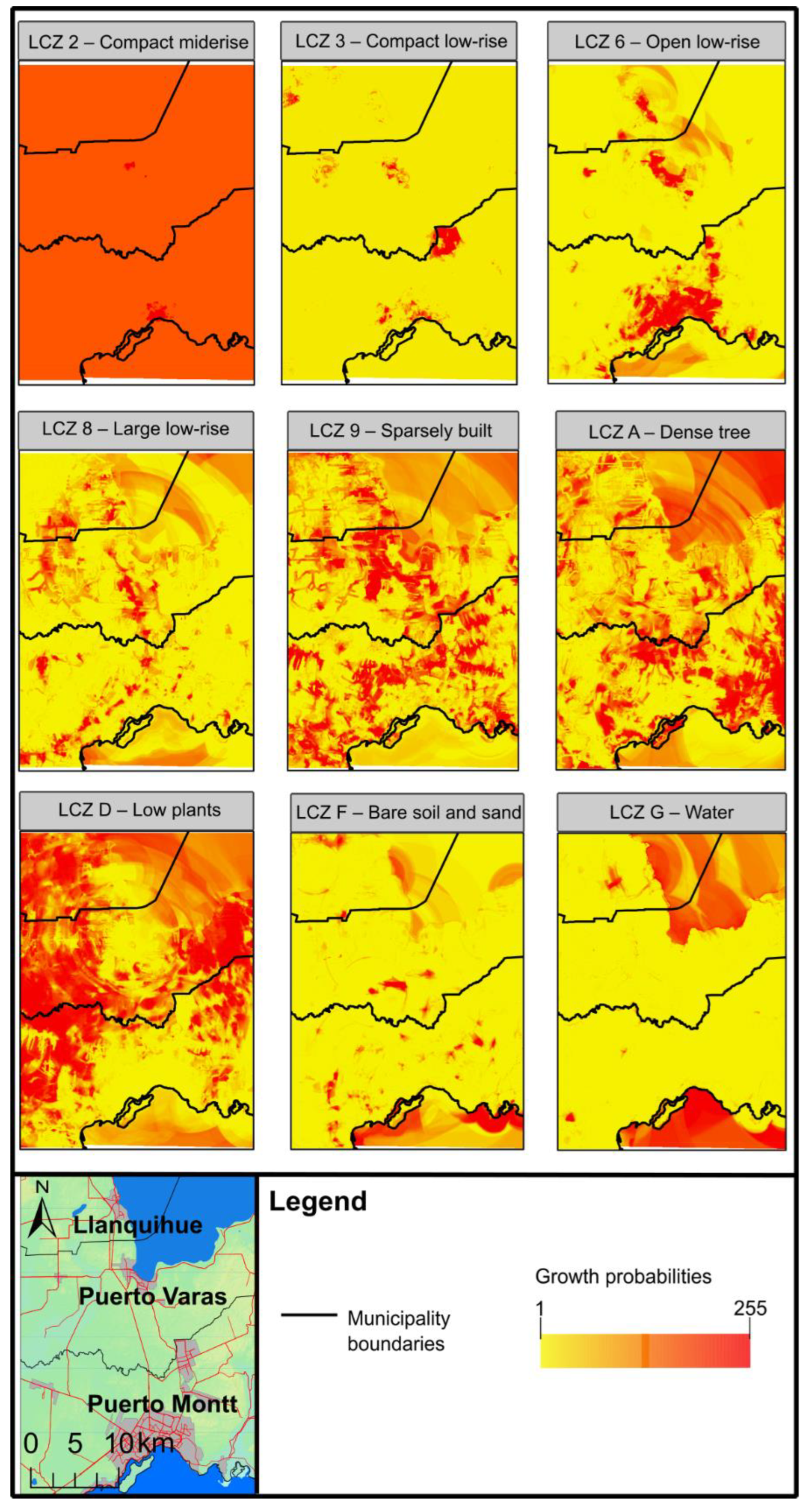
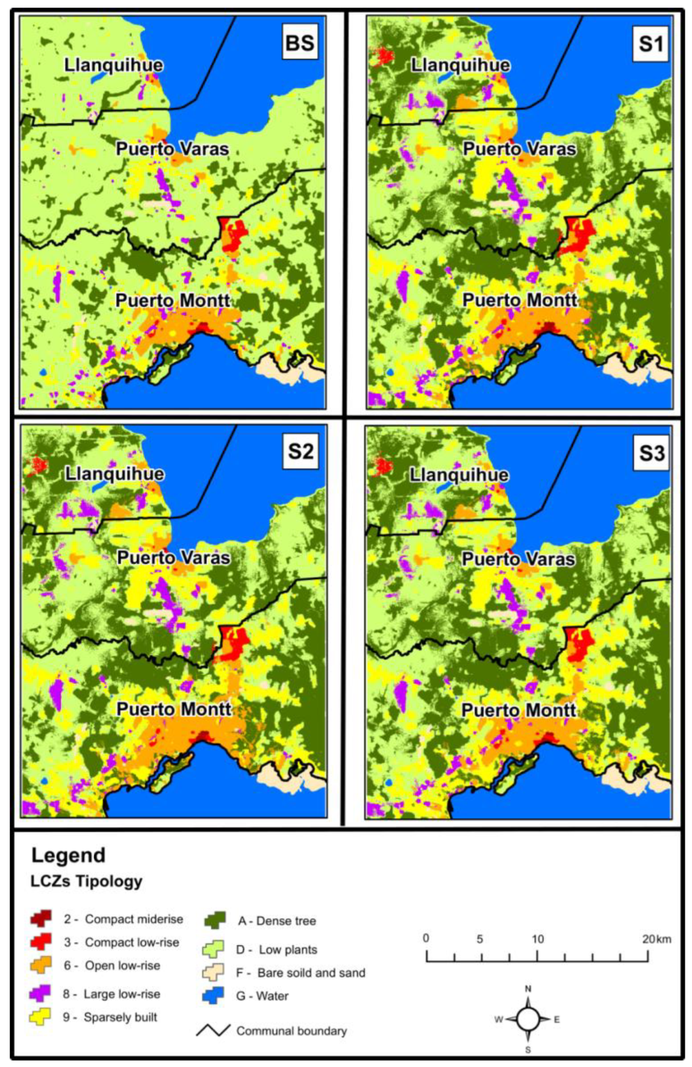

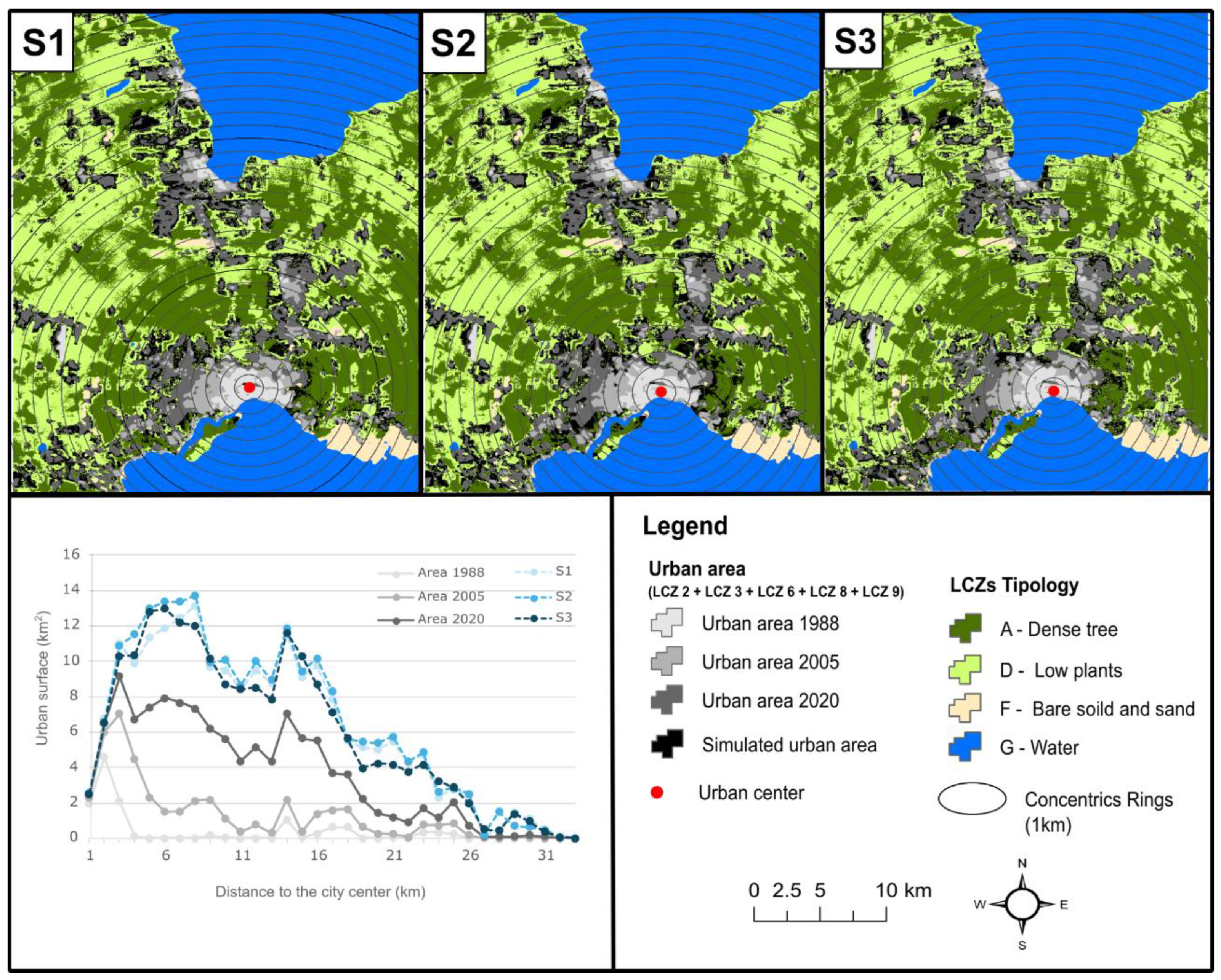
| 1988 | 2005 | 2020 | |
|---|---|---|---|
| Date images | June 5 | November 8 | January 2 |
| Images | Landsat 4 TM | Landsat 7 ETM+ | |
| Bands | B1/B2/B3/B4/B5/B7 | ||
| Cloud cover percentage | <10% | ||
| Horizontal resolution | 30 m | ||
| Dimension | Variable | Direction of Valorization | Source |
|---|---|---|---|
| Socioeconomic | Distance to financial activities | Direct | OpenStreetMap https://www.openstreetmap.org (accessed on 20 October 2023). |
| Distance to commercial activities | Direct | ||
| Distance to the structuring road network | Direct | ||
| Distance to housing real estate projects | Direct | Portal Inmobiliario, https://www.portalinmobiliario.com (accessed on 10 October 2023), TocToc https://www.toctoc.com (accessed on 15 October 2023), and Real Estate Report, Chilean Chamber of Construction, 2023. | |
| Distance to apartment real estate projects | Direct | ||
| Distance to rural land subdivision projects | Direct | ||
| Distance to educational centers | Direct | Ministry of Education, through IDE Chile, 2023. | |
| Distance to healthcare centers | Direct | Ministry of Health, through IDE Chile, 2023. | |
| Distance to main urban center | Direct | Own elaboration. | |
| Distance to secondary urban center | Direct | ||
| Distance to landfill site | Inverse | Inventory of final disposal sites, SUBDERE, 2019. | |
| Environmental | Altitude | Direct | ALOS Satellite, Japan Aerospace Exploration Agency (JAXA), 2015. |
| Slope | Direct | ||
| Sociodemographic | Population density | Direct | Population Census, National Statistics Institute (INE), 2017. |
| Housing density | Direct |
| Urban Growth Scenario for 2050 | Land Demand Estimation | Policy Development Zones | |
|---|---|---|---|
| Application of Prioritization in Specific Development Zones | Constraints on Future Urban Developments | ||
| Business-as-usual (BAU) (S1) | Calculated according to the historical trend of the LCZ using linear regression for two points, adjusted to the demand of key stakeholders. | does not apply | Hydrography (rivers, lakes, oceans) Ecological protection and biodiversity areas (SNASPE Sites) Indigenous communities Urban wetlands |
| Urban-Regional Planning (S2) | Calculated based on interviews with local stakeholders | Current urban boundary as of 2020 + 500-m buffer zone | |
| Conservationist (S3) | |||
| Typology of Local Climate Zones (LCZ) Used in the Simulations | Definition of Urban Growth Scenario | |||||
|---|---|---|---|---|---|---|
| Business-As-Usual (BAU) (S1) | Urban-Regional Planning (S2) | Conservationist (S3) | ||||
| Elasticity | Specific Development Zones | Elasticity | Specific Development Zones | Elasticity | Specific Development Zones | |
| LCZ 2—Compact mid-rise | 0.4 | does not apply | 0.4 | - | 0.4 | - |
| LCZ 3—Compact low-rise | 0.4 | 0.2 | - | 0.5 | - | |
| LCZ 6—Open low-rise | 0.6 | 0.9 | Weight 0.8 | 0.5 | - | |
| LCZ 8—Large low-rise | 0.1 | 0.1 | - | 0.1 | - | |
| LCZ 9—Sparsely built | 0.9 | 0.7 | - | 0.5 | Weight 0.8 | |
| LCZ A—Dense tree | 0.3 | 0.7 | - | 0.1 | - | |
| LCZ D—Low plants | 0.6 | 0.9 | - | 0.1 | - | |
| LCZ F—Bare soil and sand | 0.1 | 0.1 | - | 0.1 | - | |
| LCZ G—Water | 0.1 | 0.1 | - | 0.1 | - | |
| Typology of Local Climate Zones (LCZ) Used in the Simulations | ZCL Area (km2) | Rate of Change | |||
|---|---|---|---|---|---|
| 1988 | 2005 | 2020 | 1988–2005 | 2005–2020 | |
| LCZ 2—Compact mid-rise | 0.40 | 0.41 | 0.62 | 3.6% | 51.2% |
| LCZ 3—Compact low-rise | 1.49 | 2.62 | 5.64 | 75.6% | 115.3% |
| LCZ 6—Open low-rise | 8.66 | 19.57 | 41.53 | 126.1% | 112.2% |
| LCZ 8—Large low-rise | 1.44 | 6.41 | 14.79 | 345.7% | 130.5% |
| LCZ 9—Sparsely built | 0.69 | 14.26 | 55.92 | 1966.0% | 292.1% |
| LCZ A—Dense tree | 144.02 | 126.32 | 120.08 | −12.3% | −4.9% |
| LCZ D—Low plants | 588.73 | 573.95 | 499.59 | −2.5% | −13.0% |
| LCZ F—Bare soil and sand | 10.70 | 14.54 | 17.22 | 35.8% | 18.5% |
| LCZ G—Water | 229.60 | 227.66 | 230.35 | −0.8% | 1.2% |
| Total | 985.73 | ||||
| Typology of Local Climate Zones (LCZ) Used in the Simulations | Business-As-Usual (BAU) (S1) | Urban-Regional Planning (S2) | Conservationist (S3) |
|---|---|---|---|
| LCZ 2—Compact mid-rise | 0.2% | 0.1% | 0.1% |
| LCZ 3—Compact low-rise | 1.2% | 1.1% | 1.1% |
| LCZ 6—Open low-rise | 7.1% | 8.7% | 6.5% |
| LCZ 8—Large low-rise | 3.4% | 3.4% | 3.4% |
| LCZ 9—Sparsely built | 15.2% | 15.9% | 14.7% |
| LCZ A—Dense tree | 33.8% | 32.4% | 34.6% |
| LCZ D—Low plants | 36.8% | 36.2% | 37.4% |
| LCZ F—Bare soil and sand | 2.3% | 2.3% | 2.3% |
| Index | |
|---|---|
| Kappa | 0.67 |
| KLocation | 0.69 |
| KHistogram | 0.97 |
| Scenarios to 2050 | Built Urban Area (km2) | Absolute Entropy Value | Relative Entropy Value |
|---|---|---|---|
| S1 (Business-As-Usual) | 204.3 | 3.218 | 0.920 |
| S2 (Urban-Regional Planning) | 215.4 | 3.210 | 0.918 |
| S3 (Conservationist) | 198.7 | 3.207 | 0.917 |
| Ln (33) | 3.497 |
Disclaimer/Publisher’s Note: The statements, opinions and data contained in all publications are solely those of the individual author(s) and contributor(s) and not of MDPI and/or the editor(s). MDPI and/or the editor(s) disclaim responsibility for any injury to people or property resulting from any ideas, methods, instructions or products referred to in the content. |
© 2025 by the authors. Licensee MDPI, Basel, Switzerland. This article is an open access article distributed under the terms and conditions of the Creative Commons Attribution (CC BY) license (https://creativecommons.org/licenses/by/4.0/).
Share and Cite
Morales, M.; Maturana, F.; Escolano, S.; Peña-Cortés, F. Formulation of Urban Growth Scenarios for Middle-Sized Cities Towards Metropolization: The Case of Puerto Montt, Los Lagos Region. Urban Sci. 2025, 9, 165. https://doi.org/10.3390/urbansci9050165
Morales M, Maturana F, Escolano S, Peña-Cortés F. Formulation of Urban Growth Scenarios for Middle-Sized Cities Towards Metropolization: The Case of Puerto Montt, Los Lagos Region. Urban Science. 2025; 9(5):165. https://doi.org/10.3390/urbansci9050165
Chicago/Turabian StyleMorales, Mauricio, Francisco Maturana, Severino Escolano, and Fernando Peña-Cortés. 2025. "Formulation of Urban Growth Scenarios for Middle-Sized Cities Towards Metropolization: The Case of Puerto Montt, Los Lagos Region" Urban Science 9, no. 5: 165. https://doi.org/10.3390/urbansci9050165
APA StyleMorales, M., Maturana, F., Escolano, S., & Peña-Cortés, F. (2025). Formulation of Urban Growth Scenarios for Middle-Sized Cities Towards Metropolization: The Case of Puerto Montt, Los Lagos Region. Urban Science, 9(5), 165. https://doi.org/10.3390/urbansci9050165


