1. Introduction
Global demographic trends indicate an inexorable shift towards urbanization, a process that has given rise to profound socio-spatial challenges worldwide. Among the most critical of these is the proliferation of informal settlements, which currently house approximately one billion urban dwellers—a figure projected to escalate in the coming decades [
1]. These settlements, often characterized by substandard housing, insecure tenure, and inadequate access to basic services, represent a significant hurdle to achieving sustainable urban development [
2]. The uncontrolled expansion of these areas places severe strains on municipal infrastructure, exacerbates environmental vulnerabilities, and intensifies socio-economic disparities, trapping residents in cycles of poverty and marginalization [
3]. Consequently, understanding the complex dynamics of informal settlements is not merely an academic exercise but, as outlined in global development agendas, a critical necessity for fostering more equitable, resilient, and sustainable cities [
4].
Although the influence of socio-economic and political factors on urban form is widely recognized, this study deliberately adopts a morphological perspective. This focus is justified since the physical form of a settlement constitutes the tangible arena in which these complex forces manifest and where policy interventions ultimately occur. The physical dimension is frequently misunderstood and dismissed as chaotic, disordered, or haphazard [
5]. This pejorative discourse is not benign; it has tangible consequences, often leading to top-down policies of eviction and slum clearance that disrupt social fabrics, destroy localized livelihoods, and ignore the latent, self-organized spatial logic embedded within these communities [
6]. Advancing more effective and sustainable upgrading strategies that respect existing social capital requires a fundamental shift: from perceiving informal settlements as problems to be eradicated to understanding them as complex urban forms to be interpreted [
7]. Such a shift, however, necessitates robust analytical tools capable of systematically decoding the physical language of these environments.
The existing methodological frameworks for morphological analysis, while valuable, present significant limitations when applied to the unique context of informality. These limitations can be summarized across three primary domains. First, remote sensing and quantitative classification models, which have gained prominence for their scalability, often struggle with the specific physical characteristics of informal settlements. The high density of structures, the heterogeneity of roofing materials, and their complex three-dimensional forms create significant challenges for standard image analysis algorithms, often leading to classification inaccuracies and a failure to capture the fine-grained texture of the urban fabric [
8,
9].
Second, configuration models, most notably Space Syntax, offer powerful insights into the logic of street networks and their potential impact on social interaction and economic activity. However, this approach often prioritizes the analysis of “voids” (streets and paths) over “solids” (buildings, plots, and their material composition). While it can effectively decode the relational logic of the network, it overlooks the crucial role of building typology and materiality—the “hardware” of architecture—in shaping the characteristics and performance of the settlement [
10].
Third, qualitative typo-morphological studies, rooted in the rich Conzenian tradition, provide deep insights into the historical layering and cultural specificity of urban form [
11]. This approach excels at producing nuanced, human-scale understandings of how morphologies emerge and evolve over time. However, its methods are often labor-intensive, context-specific, and difficult to generalize or apply at a city-wide scale, making them less suitable for the rapid or comparative assessments needed for large-scale policy formulation. Hence, there is a clear methodological gap for a multi-scalar, replicable, form-based framework that combines the scalability of quantitative approaches with the descriptive depth of qualitative analysis [
12].
This paper addresses this gap by proposing and validating an integrated analytical framework. The primary contribution of this research is its methodological structure, offering a clear and robust tool that enables architects, planners, and researchers to discern the inherent order of informal urban forms. The innovation lies not just in the morphological analysis itself, but in the rigorous validation of the analytical framework through the Fuzzy Delphi Method and its first application within the under-researched context of Iranian informal settlements [
13,
14]. The central research question guiding this study is the following: How can a form-based analytical framework move beyond superficial descriptions of chaos to reveal the underlying morphological logic of an informal settlement? The following sections detail the development of this framework and demonstrate its utility through an in-depth case study.
The remainder of this paper is structured as follows.
Section 2 details the multi-stage methodology, outlining the development and validation of the analytical framework.
Section 3 presents the empirical results after applying the framework to the Saadi neighborhood.
Section 4 discusses the findings, highlighting their theoretical and practical implications for sustainable urbanism. Finally,
Section 5 offers concluding remarks on the contribution of the research.
2. Materials and Methods
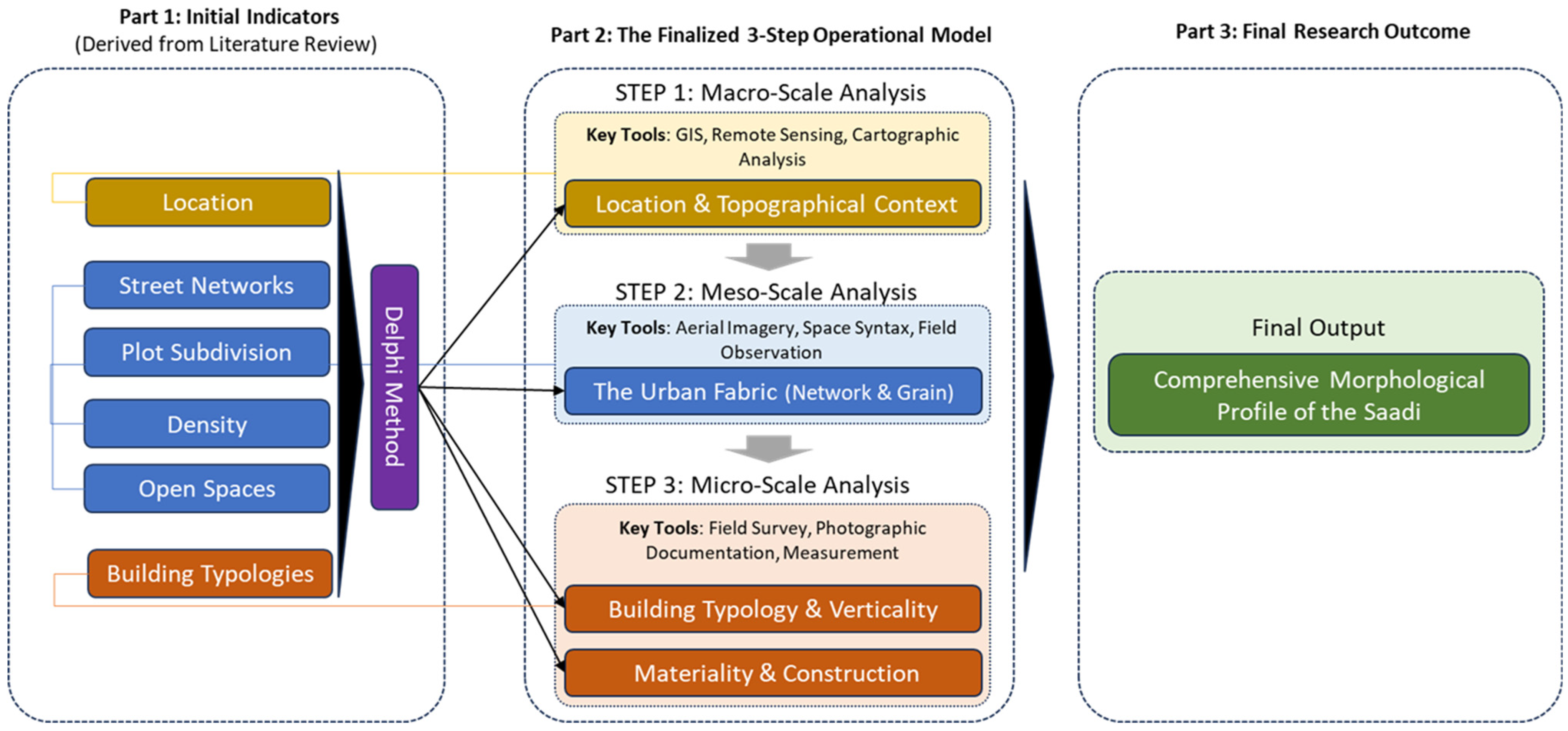
This research employs a multi-stage, sequential methodology designed to develop, validate, and apply a new framework for the morphological analysis of informal settlements. The process is structured to ensure a robust and replicable path from theoretical model-building to empirical application, as visually summarized in
Figure 1. This approach was chosen to systematically address the identified methodological gap, creating a tool that is both theoretically grounded and empirically verifiable.
2.1. Stage 1: Development and Validation of the Analytical Framework
The initial and most critical stage focused on constructing a theoretically sound and empirically relevant analytical framework. This was achieved through a rigorous three-step process designed to move from broad theoretical principles to a specific, validated set of analytical indicators.
First, an extensive literature review of foundational urban morphology theories was conducted. This included the Conzenian school’s emphasis on the historical layering of town plans [
11], the typo-morphological school’s focus on the relationship between building types and urban forms, and the configurational school’s analysis of spatial networks [
15]. This theoretical grounding was complemented by a review of seminal works on incremental housing and self-help construction [
16], which provided critical insights into the unique processes shaping informal environments. This comprehensive review yielded an initial, long list of potential form-based indicators for analysis.
Second, these indicators were refined through a comparative analysis of international case studies of informal settlements from diverse geographical contexts (Latin America, Africa, and Asia). This step was crucial to test the applicability of the theoretical indicators against the physical realities of informal urbanism. Indicators that were too abstract or difficult to observe consistently across different cases were eliminated, while others were consolidated. This process led to the development of a preliminary four-part Framework structured around what appeared to be the most fundamental and universally observable dimensions of form.
Third, to address the potential for researcher bias and to ensure the analytical power and relevance of the framework, the preliminary framework was subjected to a rigorous validation process using the Fuzzy Delphi Method (FDM). The Delphi technique is a structured methodology for achieving expert consensus [
17], and its fuzzy logic extension is particularly adept at managing the ambiguity and subjectivity inherent in expert opinions [
18]. This process involved a multi-round and anonymous survey administered to a carefully selected panel of 15 experts (see
Table 1 for profile). The panel was intentionally diverse, comprising both international scholars with a global perspective on informality and local Iranian academics and practitioners with deep, context-specific knowledge.
The FDM process unfolded in two rounds. In the first round, experts were asked to rate the relevance and importance of an initial list of indicators on a linguistic scale (e.g., “Very Low,” “Low,” “Medium,” “High,” “Very High”). In the second round, the aggregated, anonymized results from the first round were shared with the entire panel. The statistical summaries and qualitative comments included allowed each expert to see how their opinion compared to the group’s consensus and to reconsider their original assessments in light of their peers’ reasoning. Consensus was formally achieved when the variance in expert opinions fell below a pre-defined threshold, indicating a stable and collective agreement [
17]. Fuzzy set theory was then used to convert the final linguistic ratings into precise quantitative weights for each indicator, providing a robust and democratically validated foundation for the final four-part Framework: (1) Location & Topography; (2) The Urban Fabric (The term “urban fabric” (tessuto urbano) has a rich history in morphological studies, notably from the Italian school. It was used by Saverio Muratori to describe the built structure of cities as an organic whole. Unlike “texture,” “fabric” implies a living, continuous, and evolving structure, reflecting the collective process of city-making over time, a concept further elaborated by Caniggia and Maffei); (3) Building Typology & Vertical Density; and (4) Materiality & Construction. This transparent and intensive process ensures that the selected indicators are not arbitrary but are deemed most relevant and analytically powerful by a knowledgeable peer group, directly addressing the need for methodological validity.
2.2. Stage 2: The Three-Step Operational Framework for Data Collection and Analysis
The validated framework was operationalized through a hierarchical, multi-scalar process designed to systematically analyze the case study. This approach, moving from the macro to the micro scale, is fundamental to morphological analysis as it ensures that the detailed study of individual architectural elements is always grounded in an understanding of the broader urban context that contains and shapes them. The methodology integrates quantitative spatial analysis with qualitative, field-based observation to build a comprehensive and multi-layered morphological profile.
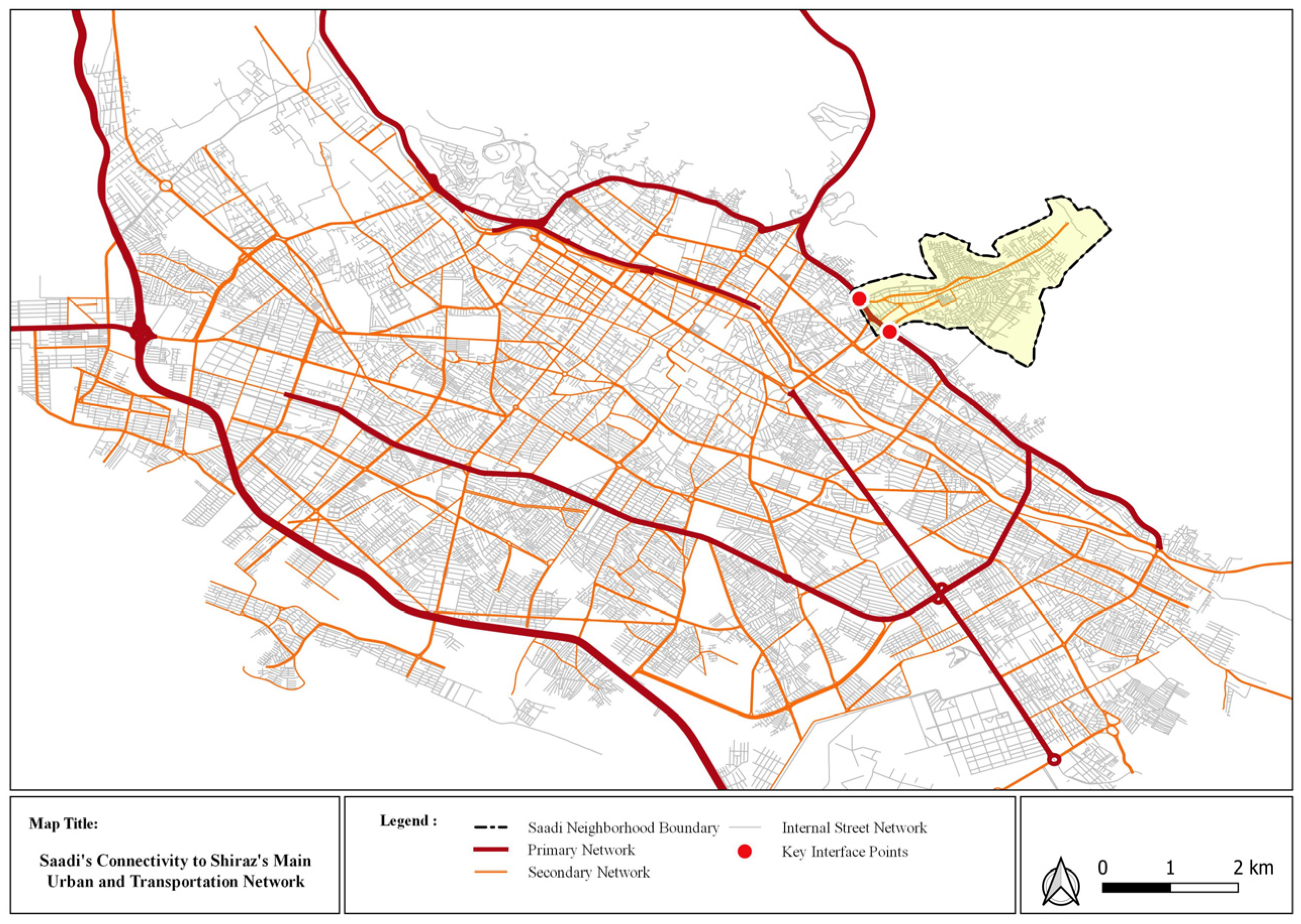
Step 1: Macro-Scale Analysis (The Contextual Frame). The analysis began at the broadest scale to understand the settlement’s relationship with its wider context and the primary natural forces shaping its existence. This step focused on the Location & Topography indicator. Using Geographic Information Systems (GIS) software (ArcGIS 10.8), Digital Elevation Model (DEM) data was analyzed to produce a detailed slope analysis map, categorizing the terrain into low-, medium-, and high-slope zones. This quantitative analysis is crucial for understanding the initial paths of settlement and the physical constraints on growth. Furthermore, satellite imagery and official municipal maps were examined to chart the settlement’s regional connectivity, identifying its primary linkages and points of friction with Shiraz’s formal transportation network. This macro-level view establishes the “geographical container” and the external forces that have fundamentally governed the settlement’s overall form and expansion logic.
Step 2: Meso-Scale Analysis (The Interstitial Fabric). Following the contextual framing, the investigation narrowed to the meso-scale to decode the internal structure of the settlement—the “space between the buildings.” This step analyzed the composite indicator of The Urban Fabric. High-resolution aerial imagery (0.5 m resolution) was used as a primary data source for digitization in a CAD environment. From this, several analytical maps were produced. Figure-Ground maps were created to visually and quantitatively assess building coverage ratios and the nature of open space. Urban Grain maps were developed by meticulously mapping individual plot boundaries to analyze the patterns of land subdivision, which is a primary generator of the urban texture [
9]. Finally, a Street Network analysis was conducted by classifying all circulation paths into a hierarchy (collectors, local streets, alleys/pedestrian paths) to reveal the logic of internal connectivity and permeability [
19]. This meso-scale analysis moves beyond viewing the settlement as a monolithic entity and begins to reveal the internal systems and patterns that govern daily life and social interaction.
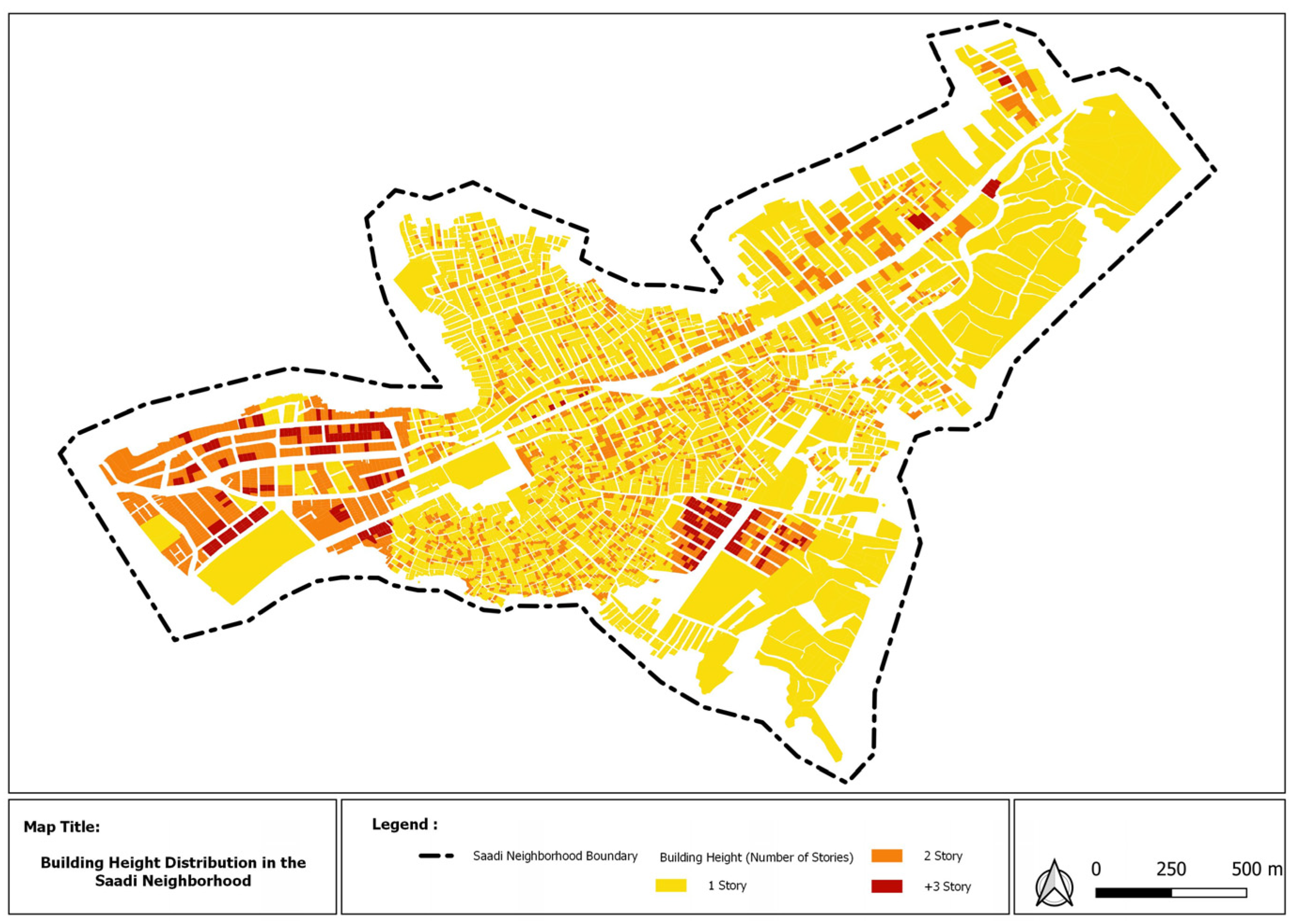
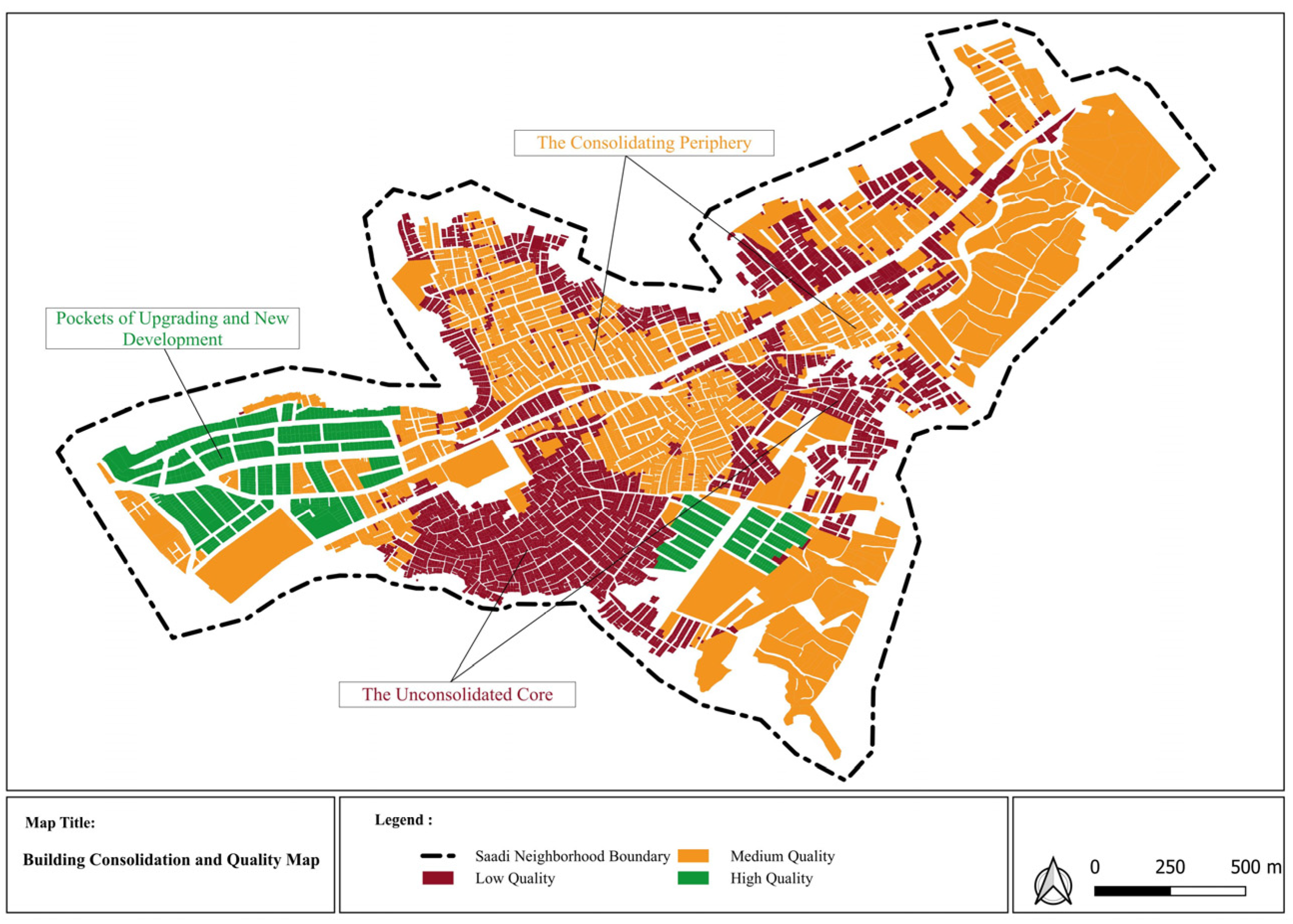
Step 3: Micro-Scale Analysis (The Architectural Objects). The final and most detailed step of data collection focused on the architectural scale, treating the individual buildings as the fundamental units of the morphology. This step investigated the Building Typology & Vertical Density and Materiality & Construction indicators. This was achieved through intensive, on-site field surveys conducted over several weeks. Systematic photographic documentation was employed to create a visual inventory of dominant building types, construction techniques, and material palettes. This qualitative data was then quantified and spatially mapped. For example, building heights were recorded for each structure to produce a thematic Building Height map, illustrating patterns of vertical densification. Similarly, a Building Quality map was developed based on a visual assessment of structural condition and material durability (e.g., temporary materials vs. permanent construction like brick and concrete), which allows for an analysis of the spatial patterns of investment and consolidation within the settlement [
20].
2.3. Stage 3: Synthesis and Case Study Context
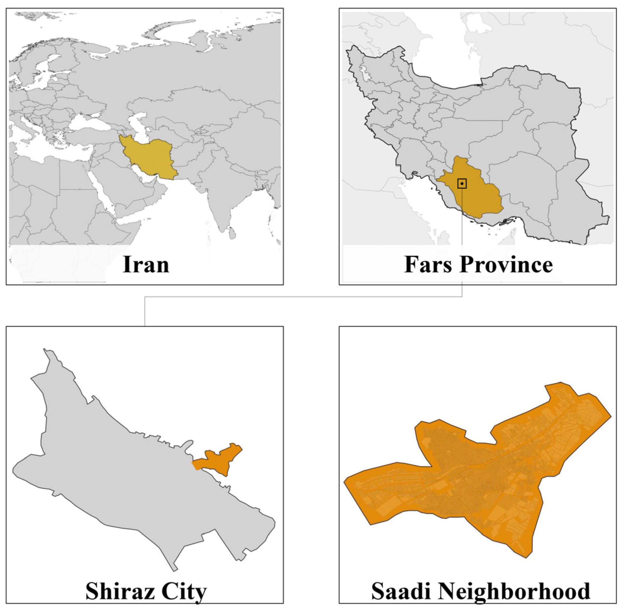
The final stage of the methodology involved synthesizing the data from all three analytical steps to construct a holistic morphological profile of the case study. This synthesis is not merely a layering of maps, but an interpretive process to understand the causal links between the different scales of analysis. The chosen case, the Saadi neighborhood in Shiraz, Iran (
Figure 2), serves as a representative example of an informal settlement that has undergone decades of incremental growth and consolidation within a challenging topographical context. Historically an ancient settlement, its contemporary form is a product of rapid, unplanned expansion over the last half-century, driven by rural–urban migration. According to official statistics, the area has a population exceeding 51,000 inhabitants, with foundational studies indicating that up to 74% of housing units were constructed without official permits and 84% of residents lack formal deeds of ownership [
21]. This condition of tenure insecurity, combined with its unique history and physical constraints, makes it an ideal setting to test the efficacy and analytical power of the proposed framework.
4. Discussion
The empirical findings of this study, which culminated in the morphological profile of Saadi as a “consolidating, low-rise, fine-grained fabric shaped by topography,” provide a powerful, evidence-based counter-narrative to the prevailing discourse of informal settlements as chaotic or disordered. This section interprets the significance of these findings, situates them within the broader academic context of urban and morphological studies, and explores their critical implications for a more sustainable and equitable approach to urban planning and policy.
4.1. Theoretical Implications: From Perceived Chaos to a Different Kind of Order
The primary theoretical contribution of this research is the empirical demonstration of a latent, self-organized spatial logic within an informal settlement. The fine-grained, pedestrian-oriented fabric of Saadi is not an absence of order but rather the presence of a different kind of order. This order is not derived from a top-down master plan but emerges from the ground up, shaped by a complex interplay of necessity, social logic, and adaptation to physical constraints [
7]. It is an order that prioritizes social networks, pedestrian accessibility, and the capacity for incremental adaptation—qualities often celebrated in the works of urban theorists like Jane Jacobs (1961) but frequently overlooked in informal contexts [
25].
Our findings align with and empirically substantiate classic critiques of top-down modernist planning, which often failed to recognize the value of complex, emergent urban systems [
26]. The concentric pattern of consolidation observed in Saadi, moving from a vulnerable core to an improving periphery, serves as a physical record of the community’s resilience and its residents’ long-term investment in their environment. This directly supports the seminal arguments of John F. C. Turner (1976), who posited that residents, when given tenure security and autonomy, are the most effective agents in their own housing processes [
27]. The morphology of Saadi is a testament to this “housing as a verb” philosophy. Therefore, by providing a systematic method to visualize and analyze this emergent order, our framework empirically challenges the pejorative stereotypes that have historically justified destructive, top-down interventions like slum clearance, arguing instead for a perspective that recognizes and values the logic of informality [
28].
4.2. Methodological and Empirical Contributions
The most significant methodological contribution of this paper is the development and successful application of the four-part, form-based analytical framework. While individual analytical techniques (like slope analysis or figure-ground mapping) may be common tools in urban analysis, the core innovation of our approach lies in their structured, multi-scalar integration within a framework whose components have been rigorously validated through the Fuzzy Delphi Method. This synthesis is what allows the framework to move beyond a collection of disparate data points to a coherent narrative that reveals the underlying morphological logic. It is in the causal connections—how topography shapes the fabric, and how the fabric enables consolidation—that the academic value of the methodology is proven [
7].
This integrated approach effectively bridges the gap between scalable but often superficial remote sensing analyses and deep but non-generalizable qualitative studies. It provides a “meso-level” tool that is both systematic enough for comparative analysis and nuanced enough to capture local specificity. Empirically, this research offers potentially one of the first in-depth, systematic morphological analyses of the Saadi neighborhood. This contributes valuable, fine-grained knowledge to the study of urbanism in Iran—a context that, despite its rich and complex urban history, remains significantly under-represented in the global literature on informality. This detailed profile can serve as a crucial evidence-based baseline for future academic research and, more immediately, for more informed and sensitive planning interventions in Saadi and similar settlements in the region.
4.3. Implications for Sustainable Urban Planning and Policy
The findings and the analytical Framework have direct and practical implications for fostering more sustainable urban development, particularly in aligning with global development agendas. Firstly, the Framework provides a practical tool to “read before you write”—to conduct a deep and respectful analysis of the existing physical and social reality before any intervention is designed. This enables planners and policymakers to move away from the destructive tabula rasa approach of “slum clearance” towards context-sensitive, in situ upgrading strategies. This approach directly supports the implementation of global policy frameworks such as the Sustainable Development Goals (specifically SDG 11: “Make cities and human settlements inclusive, safe, resilient and sustainable”) [
29] and UN-Habitat’s New Urban Agenda, which both call for participatory and in situ upgrading of informal settlements over relocation. For example, a detailed understanding of the existing pedestrian network allows for the strategic placement of new infrastructure (like water points or lighting) in a way that enhances, rather than disrupts, the social logic of the community.
Secondly, this approach promotes social sustainability by framing residents as active agents rather than passive recipients. The clear evidence of incremental consolidation is a testament to the capacity and willingness of residents to invest in their own environment. The most effective role for policymakers, therefore, is to act as “enablers” rather than providers. This involves shifting focus from the direct construction of housing units to creating a supportive ecosystem. Key policy actions should include: (a) implementing flexible and innovative forms of tenure regularization to provide the security needed for long-term investment; (b) providing targeted technical assistance on safer construction techniques and the use of more sustainable materials; and (c) facilitating access to micro-credit and financial services to support the self-managed process of housing improvement. This aligns with the well-established “enabling strategy” philosophy, which argues that state support for self-help processes yields more socially and economically sustainable outcomes than direct provision.
4.4. Limitations and Future Research
While this study provides a robust morphological analysis, its deliberate focus on physical form meant that the deeper socio-political dynamics of Saadi were only analyzed insofar as they were visibly inscribed in the morphology. A complete understanding of informality requires an interdisciplinary approach. Future research could powerfully integrate this morphological Framework with qualitative ethnographic methods, such as resident interviews and participant observation, to create a richer, multi-dimensional understanding of the relationship between spatial patterns and lived experiences [
30].
Furthermore, while the framework’s core principles are asserted to be universal, its first rigorous empirical application was a single, in-depth case study in the Iranian context. The most valuable and logical direction for future studies is to test and demonstrate its applicability through comparative research. Applying this same standardized framework to informal settlements in entirely different geographical and cultural contexts (e.g., a favela in Brazil, a slum in India, or an informal settlement in Nigeria) would be a crucial next step. Such a study would not require the Framework to be “refined” but would instead use its consistent structure to highlight the profound morphological differences and similarities across the globe, thereby contributing to a more nuanced and evidence-based global theory of informal urbanism [
31].
5. Conclusions
This study set out to develop a robust and replicable method for seeing, analyzing, and ultimately understanding the complex urbanism of informal settlements. Through a multi-stage process of theoretical synthesis, methodological development, rigorous expert validation, and detailed empirical application, this research demonstrated that the seemingly chaotic forms of informal urbanism are underpinned by a powerful and discernible logic. The proposed four-part, multi-scalar morphological framework proved to be an effective tool for moving beyond superficial and often pejorative descriptions to a deep, evidence-based analysis of urban form. The application of this framework to the Saadi neighborhood in Shiraz did not reveal a disordered slum, but rather a complex and coherent spatial system: a consolidating, low-rise, fine-grained residential fabric, fundamentally shaped by topography and incrementally built through the remarkable resilience and resourcefulness of its inhabitants.
The ultimate significance of this research, however, extends beyond its specific methodological and empirical contributions. It lies in its call for a fundamental paradigm shift in how urban informality is perceived and engaged with. By offering a practical tool to “read before you write,” this research advocates a shift from the prevailing planning culture that views informal settlements as problems to be eliminated toward one that recognizes them as complex, adaptive urban systems. These systems, while facing immense challenges, often contain valuable lessons in affordability, community-led development, and human-scale design that are relevant for creating more humane, resilient, and inclusive cities for all. For planners, architects, and policymakers, the primary task is therefore not to impose a preconceived and often alienating order from the outside, but to develop the capacity to see, understand, and strategically support the powerful, self-organized order that is already there.
