Article

Green Corridors and Social Connectivity with a Sustainable Approach in the City of Cuzco in Peru

1
Faculty of Architecture and Urban Planning, Ricardo Palma University, Santiago de Surco, Lima 15039, Peru
2
Research Laboratory for Formative Investigation and Architectural Innovation (LABIFIARQ), Santiago de Surco, Lima 15039, Peru
3
Faculty of Environmental Geographic Engineering and Ecotourism, Federico Villarreal National University UNFV, San Miguel, Lima 15088, Peru
*
Author to whom correspondence should be addressed.
Urban Sci. 2024, 8(3), 79; https://doi.org/10.3390/urbansci8030079
Submission received: 29 February 2024 / Revised: 20 June 2024 / Accepted: 21 June 2024 / Published: 6 July 2024

Abstract

:
The present research aims to propose the design of a green corridor with a systemic/sustainable approach to function as an ecological lung for the city of Cuzco. A lack of planning has resulted in uncontrolled urban development, with a shortage of green areas, negatively affecting the quality of life. Green corridors stand out as solutions that encourage social interaction and improve public health. This approach recognizes the need for balanced resource management and institutional, economic and social organization. In the specific case of Cusco, the lack of social interaction highlights the importance of addressing these challenges to improve the quality of life for both residents and visitors. The methods developed were an extensive literature review, urban analysis and climate analysis, applying sustainability strategies supported by digital tools (Google Earth, Climate Consultant 6.0, Autocad, SketchUp and 3d Sun Path). As a result, this proposal presents green areas covering 69.96% of the total area, aimed at providing recreational spaces and connecting residents and visitors with nature. Additionally, biolakes were designed, accounting for 3.18% of the area, serving as ornamental elements and contributing to the environmental quality of the urban environment. The botanical zone, encompassing 18.14% of the project, was designed to accommodate a diverse range of plant species, providing an educational and aesthetic environment. The convention area, representing 9.7% of the total area, was designed to host events and community activities, promoting social and cultural interaction. Finally, 0.98% of the space was allocated to the cultural zone, where artistic exhibitions, cultural events, and related activities can be planned, enriching the cultural and social life of the community. These percentages reflect careful consideration of the needs and aspirations of the population, as well as a comprehensive approach to sustainable urban design and the creation of multifunctional spaces. In conclusion, through a green corridor, the aim is to counteract uncontrolled urban expansion and environmental degradation by generating a green lung in the city of Cuzco, naturally regulating the climate and contributing to air and water purification. The absence of green corridors and sustainable approaches to social connectivity in Cusco could reduce the quality of life of residents, affecting their physical and mental health. The lack of green and recreational spaces could increase segregation and alienation in the community, weakening social cohesion. Without green corridors, the city would also face environmental and biodiversity challenges, as well as a reduced ability to respond to extreme weather events. The lack of implementation of these strategies could compromise comprehensive development and quality of life in Cuzco.

1. Introduction

The inevitable increase in urbanization and the reduction in urban quality of life over the coming years have driven the development of city sustainability. Consequently, compact cities with high population densities are opting for the creation of green spaces to complement residential areas as a means of fostering interpersonal relationships. Currently, urban areas are growing exponentially without proper planning, resulting in a false sense of green area development and, consequently, a decline in people’s quality of life, failing to meet the minimum requirements for a fulfilling life [1,2].
Today, in the pursuit of this solution regarding the road system and pedestrianization, it becomes counterproductive to city development, specifically in the area of green spaces, due to the uncontrolled overcrowding of urban areas [2]. Consequently, public spaces, which allow for interaction between users and nature, are becoming increasingly important, generating opportunities for greater connectivity through systems such as green corridors. Moreover, regular social interaction in green spaces contributes to the strengthening of community bonds and fosters connection among inhabitants, even generating positive health benefits for individuals [3].
This social interaction also considers the accessibility of urban green spaces as a pillar for the progress of urban sustainability, not only environmental but also economic and social [4]. Thus, it promotes an approach that ensures balanced resource use to guarantee the long-term viability of the urban environment and human development, establishing an advancement in environmental focus and its issues, incorporating into the traditional vision of the urban environment the variables of the human environment and focusing on its institutional, economic, and social organization [5].
As a complement to achieving the objectives of the sustainable approach, the concept of a systemic approach is analyzed and understood. It is derived from the relationships within a system formed by interconnected elements that interact within the same framework, seeking an integral solution that extends into the architectural sphere, emphasizing the relationship of the user with the organization, complexity, and totality of spaces [6,7].
Among the cities with lower social interaction, Cuzco stands out, with a current population of 1,316,729 inhabitants, making it one of the nine most populous departments in Peru [8]. Its growth over the years has been inconsistent, always expanding with a tendency to the East, reaching 385.1 km2. This has also positioned it as one of the most visited cities by tourists, due to its numerous natural and cultural attractions, with 33% of foreign tourists and 67% of domestic tourists [9] (Table 1).
Additionally, the city of Cuzco exhibits a lack of urban quality due to the presence of narrow and congested roads that hinder pedestrian movement, directly affecting inefficient bike lanes and prioritizing motorized vehicles, thus posing dangers to pedestrians [10,11]. Moreover, Cuzco lacks a sufficient number of public spaces to revitalize the Huatanay River, which could lead to the ecosystem producing foul odors, pests, and losses of fauna and flora species [12]. There is also a lack of public buildings that would allow for the appropriation of space, resulting in a lack of interaction among people, thus hindering social connectivity [13] and fostering informality that affects the city’s economy [14].
As a consequence of the poor urban quality, pollution caused by illegal mining in the region is prevalent [15,16]. In these cases, mining residues are in continuous contact with oxygen, generating mine acids that contaminate the Huatanay River [16] and the soils throughout the region, consequently exacerbating the deficit of green areas. There is an estimated 745,838.94 m2 of public green areas with an index of 6.42 m2 of green area per inhabitant, below the minimum of 9 m2 per inhabitant according to the World Health Organization (WHO) [17].
This deficiency in green areas is reflected in Figure 1a, which depicts the interior of the Teniente Alejandro Velasco Astete International Airport, highlighting the excessive urban crowding and scarcity of green areas both inside and around the airport. Not only that, but significant avenues, urban axes, and various infrastructures are also interrupted, segmenting the diverse uses assigned to the surrounding blocks and jeopardizing the quality of public spaces. This situation stems from the location of this airport with a perimeter fence in the heart of the Wanchaq tourist district, generating complications for the formation of a more accessible urban fabric that facilitates a more efficient distribution of vehicular and pedestrian flow [18]. This perimeter fence is delimited by 95% with blind walls of 3 m in height, except for its main entrance on Av. Velasco Astete, influencing the quality of urban travel. This is similar to the perimeters of metropolitan-scale facilities present in Lima, which are often delimited by blind walls and an immediate environment that is interrupted by that perimeter dividing edge [19]. Meanwhile, in Figure 1b, Daniel Estrada Pérez Street can be visualized alongside the aforementioned blind walls that form the perimeter of the International Airport. Similar to the previous figure, the presence of narrow and congested roads that affect the urban fabric, hindering pedestrian movement through them, is evident [20]. This problem arises due to the variability in the sizes and dimensions of the blocks and sidewalks, resulting from attempts to adapt them to the airport’s configuration. As a result, the surroundings of the airport terminal have streets with few crossings, are difficult to locate, have a deficit of green areas, and are accompanied by blind walls that increase the perception of pedestrian insecurity and complicate accessibility by lacking a multidirectional pattern and not being pedestrian-focused [21].
In Figure 2a, a more detailed view of the origin of the problem affecting the urban fabric and the variability in block dimensions can be observed. It shows, in chronological order, the urban expansion of the province of Cusco, starting from the Historic Center and extending to the district of San Jerónimo. This growth has led to urban overcrowding and the formation of a disordered urban fabric, represented as a broken plate due to the irregularity in its expansion, which is still ongoing. The formation of irregular blocks hinders the efficiency of the development of road infrastructures, reflected in narrow and poorly defined streets, with a significant impact on road safety and an environment that presents challenges for mobility and traffic planning [22].
The population growth rate of Cuzco has led to unbridled urban expansion due to the demand for housing, infrastructure, and employment. However, this growth has been accompanied by alarming environmental consequences, including ecological imbalance and deforestation [23]. Figure 2b illustrates the lack of green areas in Cuzco due to the exponential increase in population, which has exerted significant pressure on the region’s natural resources, leading to massive tree felling, destruction of natural habitats, fragmentation of local forests, disturbance of ecosystems, and posing a threat to the unique biodiversity of the area [24]. Additionally, deforestation has led to a loss of vital ecosystem services, such as climate regulation, water purification, and landslide prevention. These phenomena, in turn, increase the vulnerability of local communities to natural disasters and extreme weather events [25], negatively impacting local flora and fauna as well as people’s lives [26].
Therefore, the present research aims to propose the design of a green corridor with a systemic/sustainable approach to function as an ecological lung for the city of Cuzco.

2. Materials and Methods

2.1. Methodological Framework

The design approach was carried out through an exhaustive analysis of the environment and the study area, which allowed for the collection of relevant data. These data were subsequently used by multidisciplinary technical teams, who integrated the various diagnostics of the location to address the identified problems and set specific objectives [27].
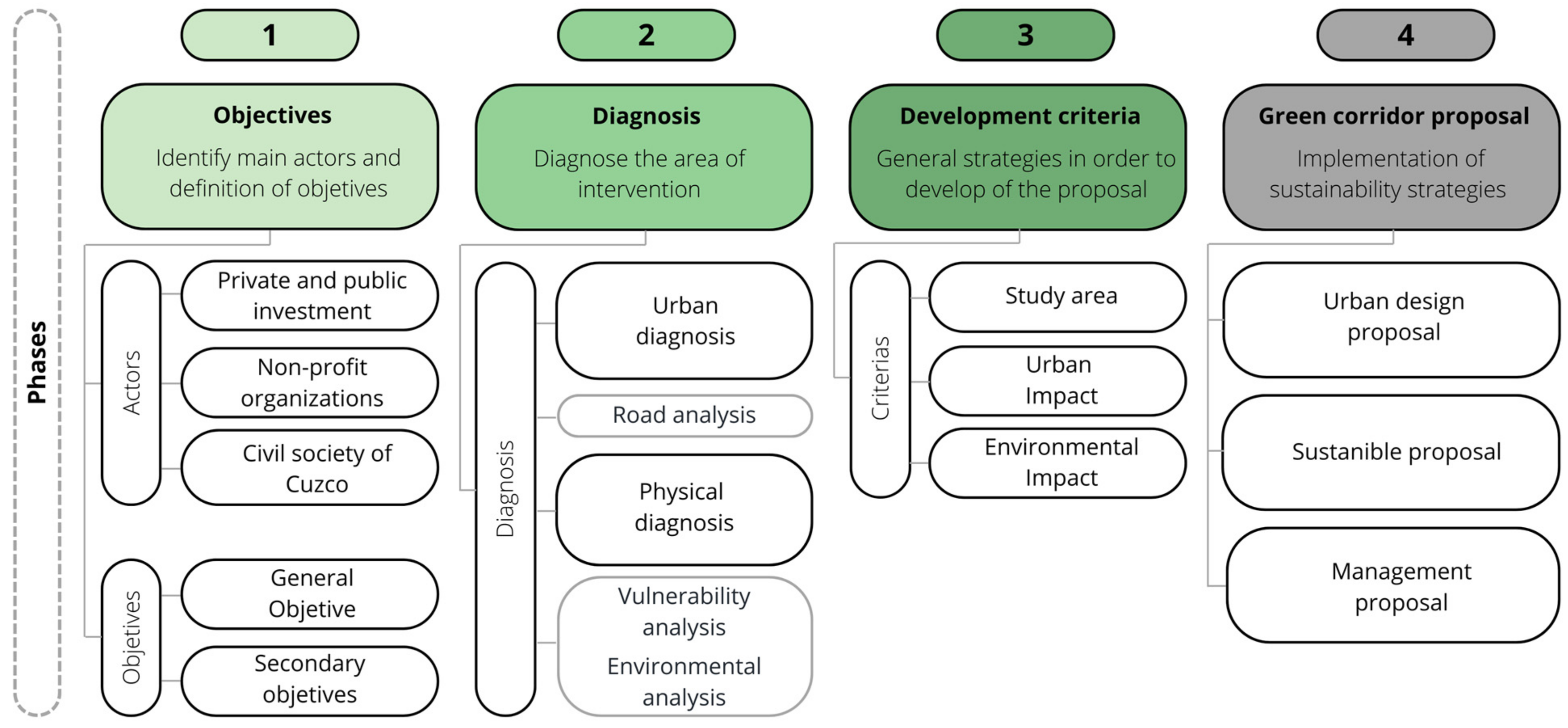
In Figure 3, to develop a project that provides both environmental and socio-cultural benefits, it is essential to integrate these perspectives with the needs of the residents and main users. It is crucial to adopt new planning paradigms that focus on the analysis of various urban ecosystem processes, the associated ecosystem services, and the variations in the quality and quantity of resources derived from land use. In this framework, natural or semi-natural ecosystems can be essential for solving problems related to climate change and its impacts on the territory [28]. The process must follow these steps:
  • Identify main actors and definition of objectives.
  • Diagnose the area of intervention.
  • Establish general strategies to develop the proposal.
  • Implement sustainability strategies.
Figure 3. Methodological framework.
Urbansci 08 00079 g003

2.1.1. Identify Main Actors and Definition of Objetives

To initiate the project, it is crucial to conduct a preliminary identification of potential objectives, general guidelines, and issues to be addressed by introducing green corridors in the urban environment. These objectives will serve as the foundation for the initial sketches of the urban green corridors and facilitate the identification of key actors for their participation. Forming strategic alliances to support various stages of planning and execution is vital. Regarding stakeholder identification, a mapping process should include public and private entities, civil society organizations, and non-profit organizations. This approach ensures stakeholder participation in the different phases of the project, from planning to execution and maintenance.

2.1.2. Diagnose the Area of Intervention

Once the areas for the urban green corridor have been identified, the first step is to diagnose the area of intervention based on two axes: physical and urban landscape. This will allow for the identification of the components and dynamics of these areas.
  • Diagnosis of the Physical Environment: recognize significant characteristics of the physical and biological elements in the territory, starting with a general evaluation of the city’s environment and focusing on the sections selected for the creation of the corridor.
  • Diagnosis of the Urban Environment: Understand the urban characteristics of the intervention area, including public green spaces, paths, trails, signage, existing facilities, and future projects planned by the local government. This information is crucial for determining the corridor’s route and the elements of the comprehensive proposal.

2.1.3. General Strategies to Develop of the Proposal

After completing the diagnosis phase, general strategies will be established to guide the development of the urban green corridor proposal. Interventions should be supported by previous studies and should respond to an integrated vision. The proposal should be based on two fundamental axes: urban landscape and environmental approach.
  • Spaces that are part of public green areas: Identify and recognize green spaces and public areas within the city. Use planning documents with maps and data on preservation and conservation areas, urban green spaces, parks, and public areas of different scales (zonal, urban).
  • Spaces for the integration and improvement of natural resources: Recognize connecting elements, both natural and human-altered, present in the city. Use maps of road infrastructure, pedestrian routes, watercourses, and information on native flora and fauna.
  • Spaces to articulate existing and/or planned urban projects: Examine strategic urban projects for their importance in terms of tourism, entertainment, or other aspects. Use cartographic information, satellite images, and photographs to define the corridor’s route and establish location criteria efficiently.
In Figure 4, detailed information is collected using state-of-the-art digital tools. In stage 1 of applications such as Google Earth, a detailed analysis of the environment is carried out, covering topographic aspects, existing infrastructure, green areas, etc. At the same time, in stage 2, Climate Consultant is used to obtain accurate data on the climate and environment, including variables such as solar radiation, wind direction and temperatures. In stage 3, AutoCAD and BIM methodology are used for the 2D urban planning phase in which the layout and elements of the proposal are detailed.
The design processes are based on parametric and generative design, which allows for generating, analyzing, and correcting multiple design alternatives. The objective of using digital tools was to automate the development of the urban design concept for selected land units with a local development plan. Following ordinances and other sources, the program takes data to create geometric objects with correct relationships, evaluating the results with calculated indices and generating new alternatives based on the best options. The results were compared with other studies in an exhaustive literature review, highlighting the focus on green infrastructure design and the use of BIM methodology for architectural design [29].
BIM can be considered from two perspectives: a broad one and a more specific one. In a broad sense, BIM is a process that involves the collaboration of people, information systems, databases, and software, and it can even encompass hardware and both tangible and intangible resources. In a more specific sense, BIM is a semantic database of the construction object that accompanies it throughout its lifecycle [30].
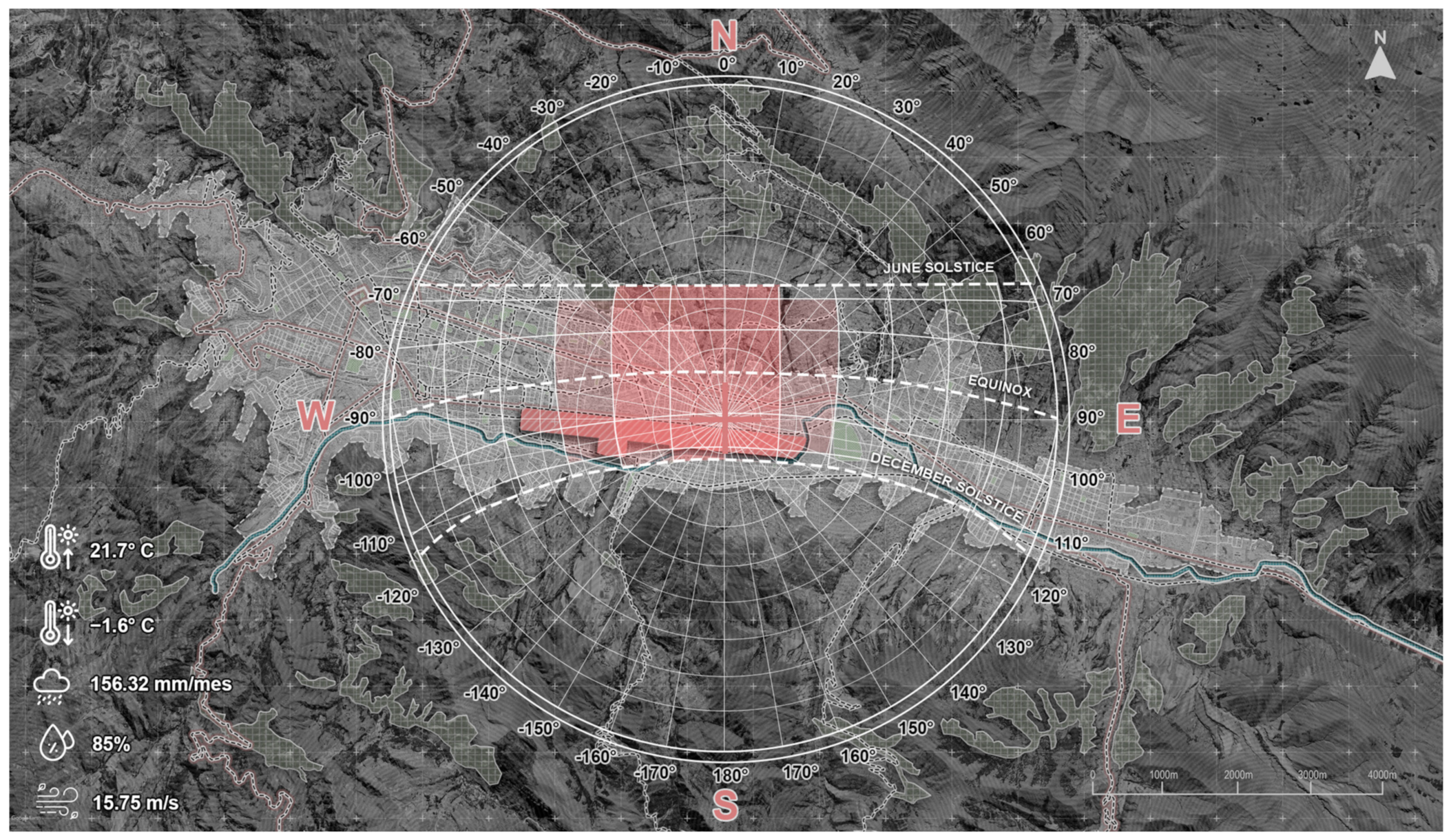
In stage 4, 3D Sun Path is used for solar impact analysis. This specialized tool facilitates a comprehensive examination of how sunlight interacts with our proposal throughout the day and in various seasons.

2.1.4. Implementation of Sustainability Strategies

Urban green corridors are significant green infrastructure projects that impact urban planning. They will prioritize non-motorized mobility, promote biodiversity in urban environments, protect and clean watercourses (such as the Huatanay River, irrigation channels, bio-lakes), and develop urban spaces with recreational areas for public enjoyment. Implementation must ensure the long-term sustainability of the project, considering both continuous maintenance and active community participation in its management and use.
Structuring the project in this manner ensures comprehensive planning that addresses everything from the identification of actors and objectives to sustainable implementation through a detailed diagnosis of the area and the development of effective strategies.

2.2. Study Area

The city of Cuzco is located on the eastern slope of the Andes mountain range, covering an area of 61,700 hectares, with a total population of 410,469 inhabitants [31]. Its significance dates back to ancient civilizations, as this city became, under the rule of the Inca Pachacútec, a complex urban center with distinct religious and administrative functions, where the surrounding area was divided into clearly delimited zones for agricultural, artisanal, and manufacturing production [32].
Figure 5 shows the general geographical location of the intervention area, which is in the province of Cusco, the capital of the Cusco department and comprises 8 districts (Cusco, Wanchaq, Santiago, San Sebastián, San Jerónimo, Saylla, Poroy, and Ccorcca). This area is characterized by its importance in the country’s history and its Inca architecture [33]. The province of Cusco is mostly urban and one of the most visited areas in Peru due to its historical and cultural heritage, such as the ruins of Machu Picchu and other archaeological sites [34].

2.3. Diagnosis of Study Area

2.3.1. Urban Analysis

  • Road Analysis
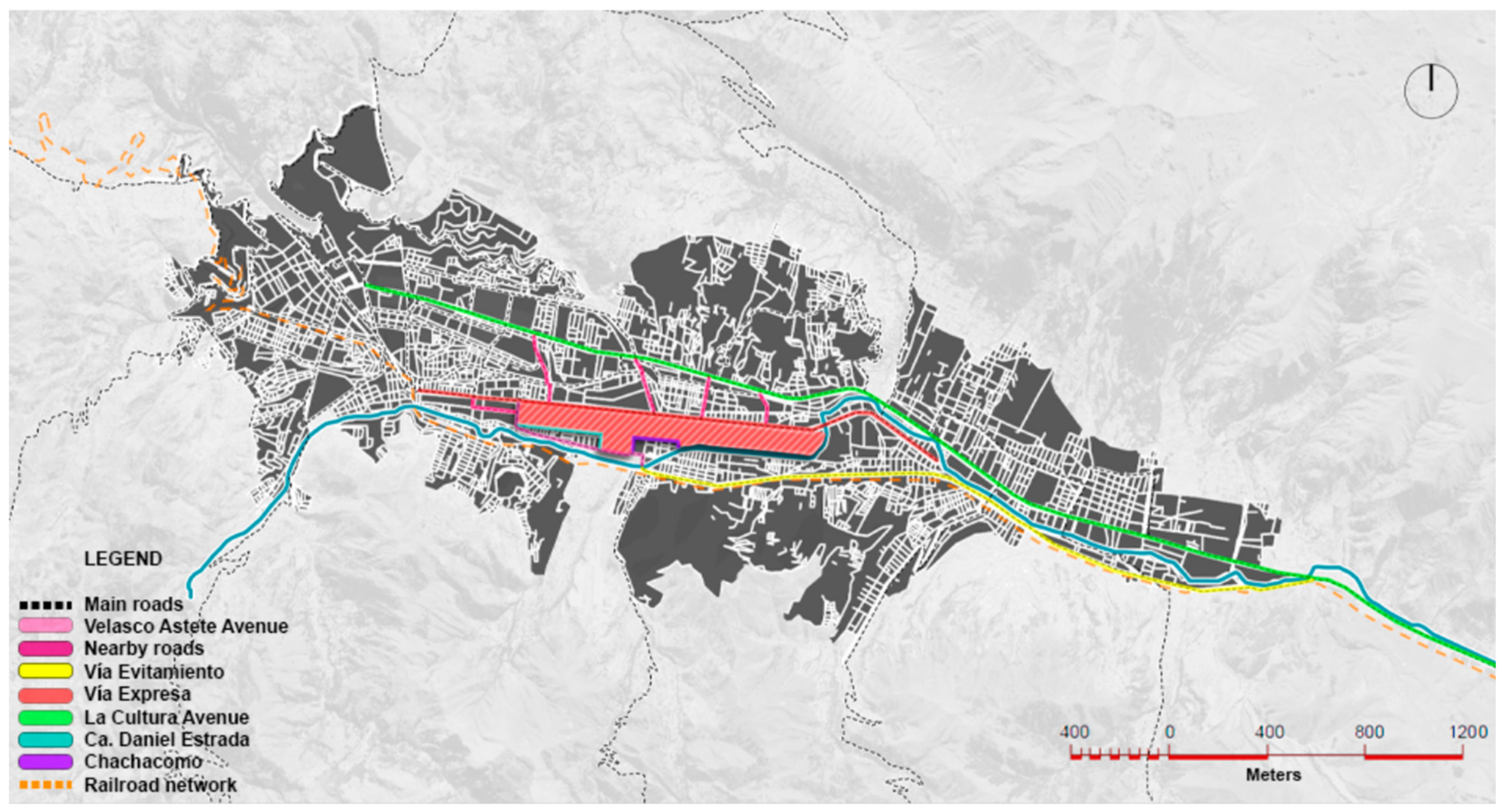
In Figure 6, the road diagram marks the different types of roads present in the city of Cuzco, among which Av. La Cultura stands out for crossing the department of Cuzco, and in magenta lines, the streets that interconnect with the terrain are highlighted. Due to its broken plate morphology, the city of Cuzco presents a geometry of irregular blocks, which influences the easy vehicular congestion of the arterial roads. The roads adjacent to the terrain are the Expressway, Av. Velasco Astete, Daniel Estrada Street, and Chachacomo Street, and other closer and more important ones are the Bypass, Av. de la Cultura, and a railway network [35].
  • Vulnerability Analysis
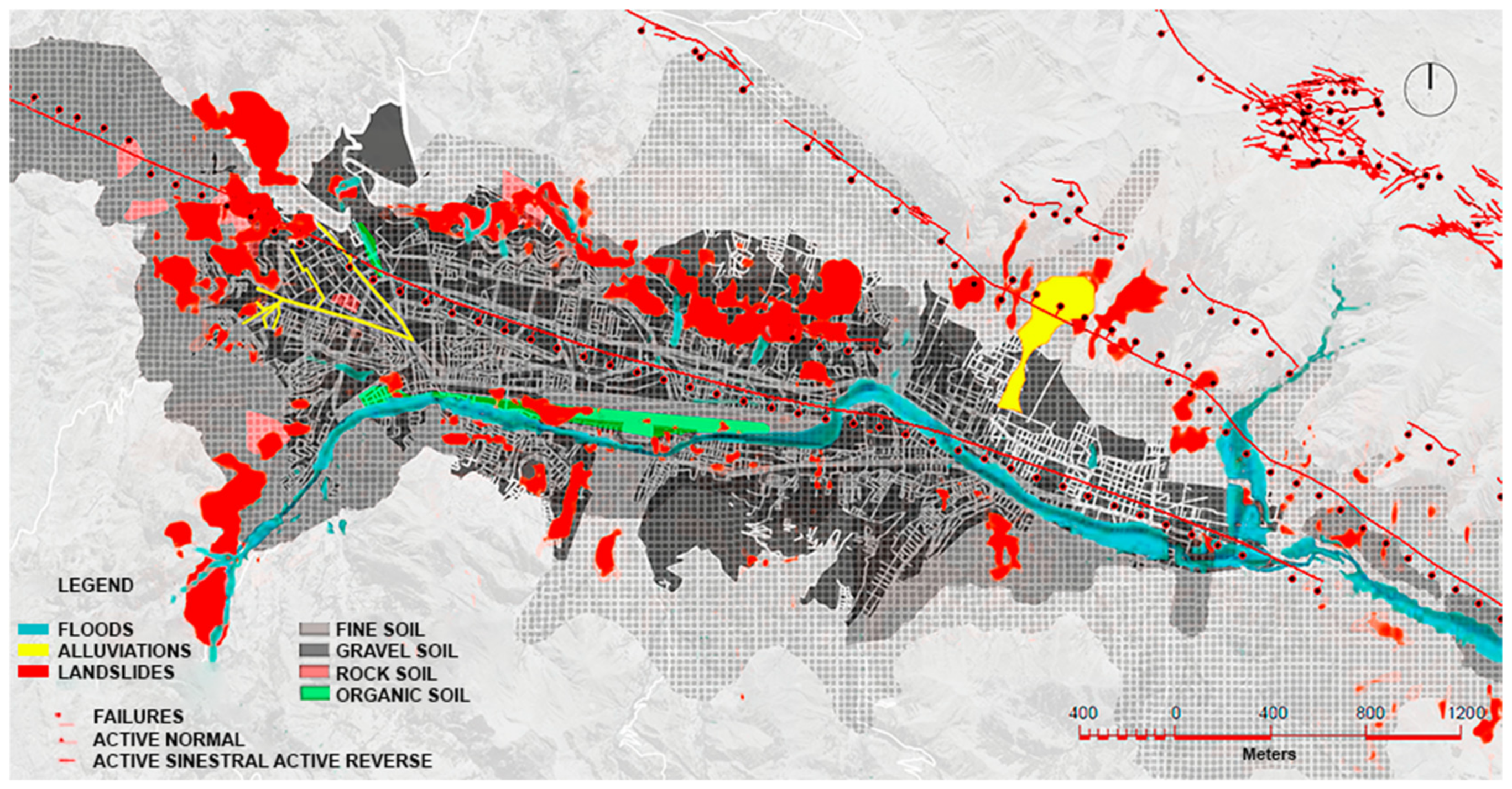
In Figure 7, the vulnerability of Cuzco due to its location in the valley and the proximity of the Huatanay River is highlighted. The areas near the river are especially prone to flooding, which presents a significant risk to inhabited areas and infrastructure. Additionally, the terrain of the Wanchaq airport contains organic soil and is affected by landslides in some areas.
The different types of soils present in Cuzco include fine soil, gravel, and rock, each with specific characteristics and challenges. The presence of geological faults and alluviums is also noted, which represent additional risks. Faults can concentrate tectonic stresses, increasing vulnerability to earthquakes, while alluviums can drastically modify the landscape and affect infrastructure [36].
  • Environmental Analysis
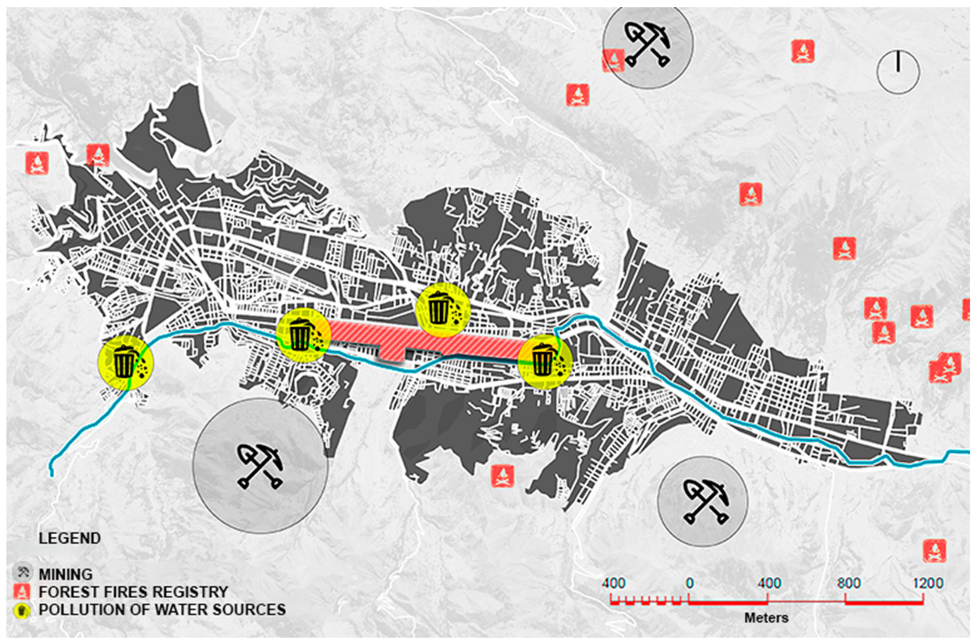
In Figure 8, it can be observed that Cuzco faces several immediate environmental challenges that affect both its ecosystem and the quality of life of its inhabitants. Mining activity is concentrated in areas far from the urban zone, which reduces the direct exposure of the population to pollution. However, the risks associated with mining, such as soil degradation, biodiversity loss, and water source contamination, remain significant and require proper attention and regulation.
Additionally, the figure shows a higher risk of forest fires in the wooded areas of Cuzco, highlighting the need for preventive and control measures to protect forest resources and maintain the ecological balance of the region. Finally, the issue of water pollution along the Huatanay River is highlighted, affecting water quality and the health of aquatic ecosystems.

2.3.2. Climatology

Cuzco is located at 3205 m above sea level in an inter-Andean valley, meaning its climate is generally semi-cold with semi-dry to rainy terrain, with average rainfall of 156.32 mm and an average temperature of 12 °C [37].
The temperature range present in Cuzco is depicted in Figure 9, where the maximum temperature recorded was 27.5 °C in May, and the minimum was −2.5 °C in June. Additionally, it can be observed that the month of April had a maximum wind speed of 15.75 m/s, while June had the lowest wind speed at 8.2 m/s [38].

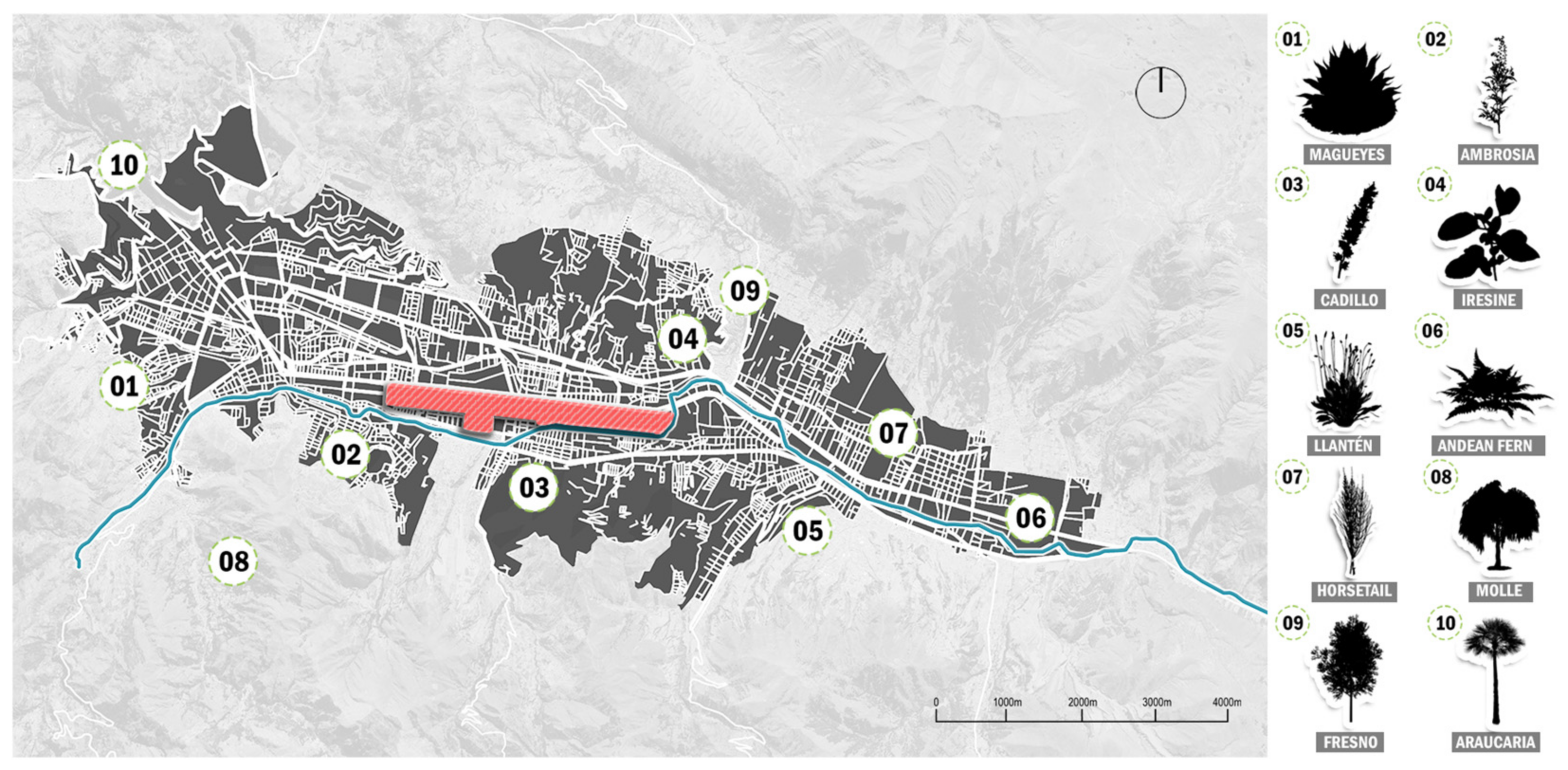
2.3.3. Flora

Cuzco boasts a wide variety of plants adapted to the cold and dry climate, with some capable of withstanding temperature changes and lasting for centuries. In terms of orchids alone, there are approximately 370 types in the Machu Picchu area [39].
Figure 10 illustrates the different species of flora along with the location of the most predominant ones and their respective common and scientific names for better understanding and classification of the provided information. The place containing the highest diversity of flora in the Historic Center of Cuzco is the Plaza San Francisco, which stands out for exhibiting the greatest abundance of native tree and shrub species, which have been used for urban arboriculture for an extensive period, including native species such as the Molle and introduced species such as the Araucaria [40].

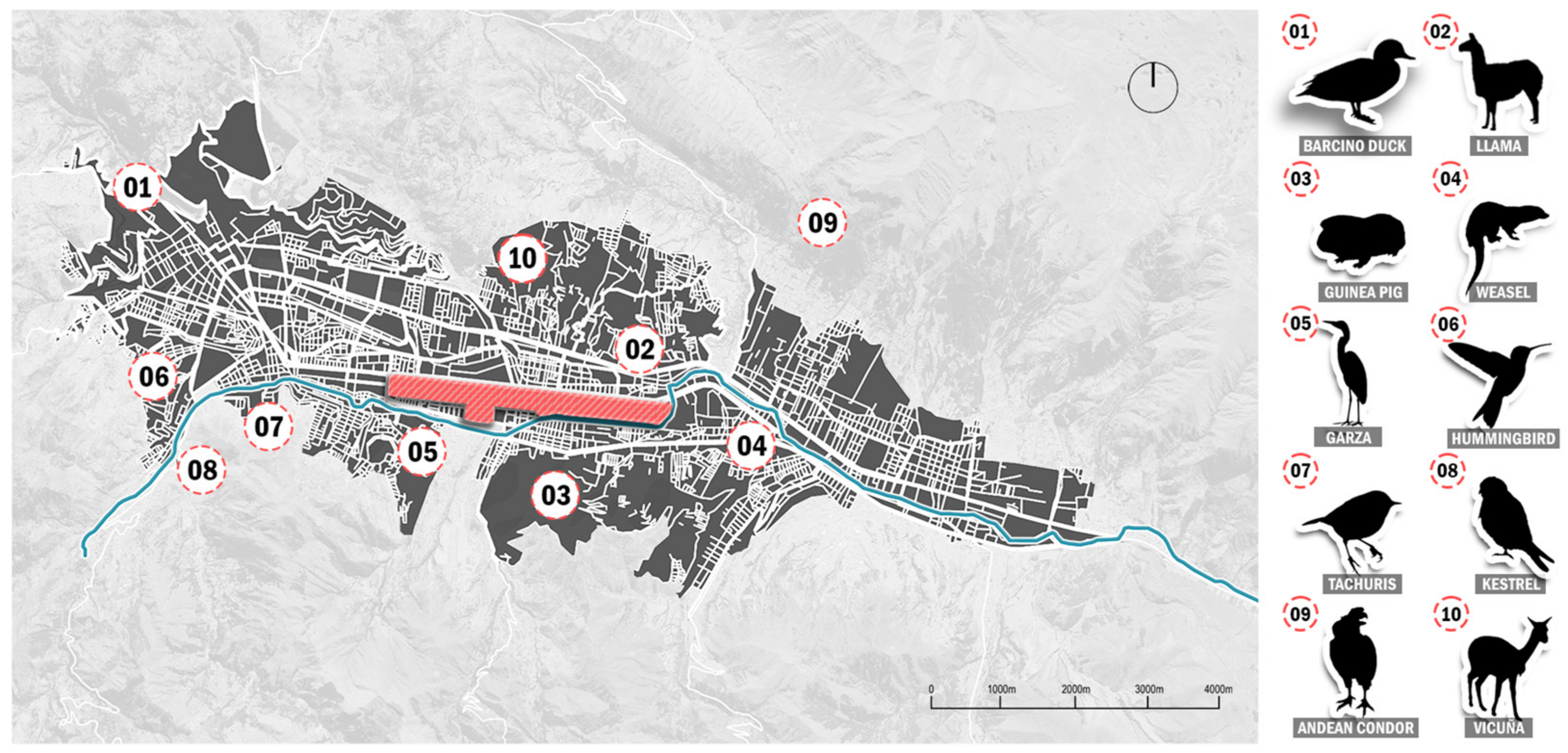
2.3.4. Fauna

Regarding fauna, due to the good state of the vegetation formations, numerous species were found. In the Historic Sanctuary of Machu Picchu alone, 13 species of fish, 15 species of amphibians, 23 species of reptiles, 423 species of birds, and 70 species of mammals were recorded [41].
Figure 11 displays some of the different predominant species in the wildlife fauna of our study area, along with their location and respective common and scientific names. This graph reveals the presence of only 4 out of 40 bird species, with 62.5% of them belonging to the forest itself and the outskirts of the city. As for mammals, the following species were recorded: H. antisiensis, Lama glama (“llama”), and L. pacos (“alpaca”) within the Camelidae family, as well as L. peruanum, considered the easiest to find in the area [42].

3. Results

3.1. Project Location

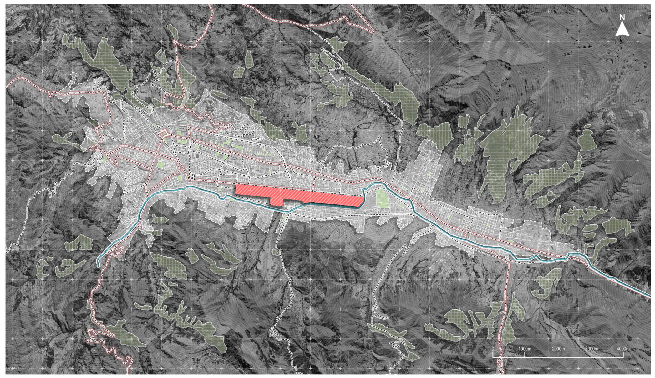
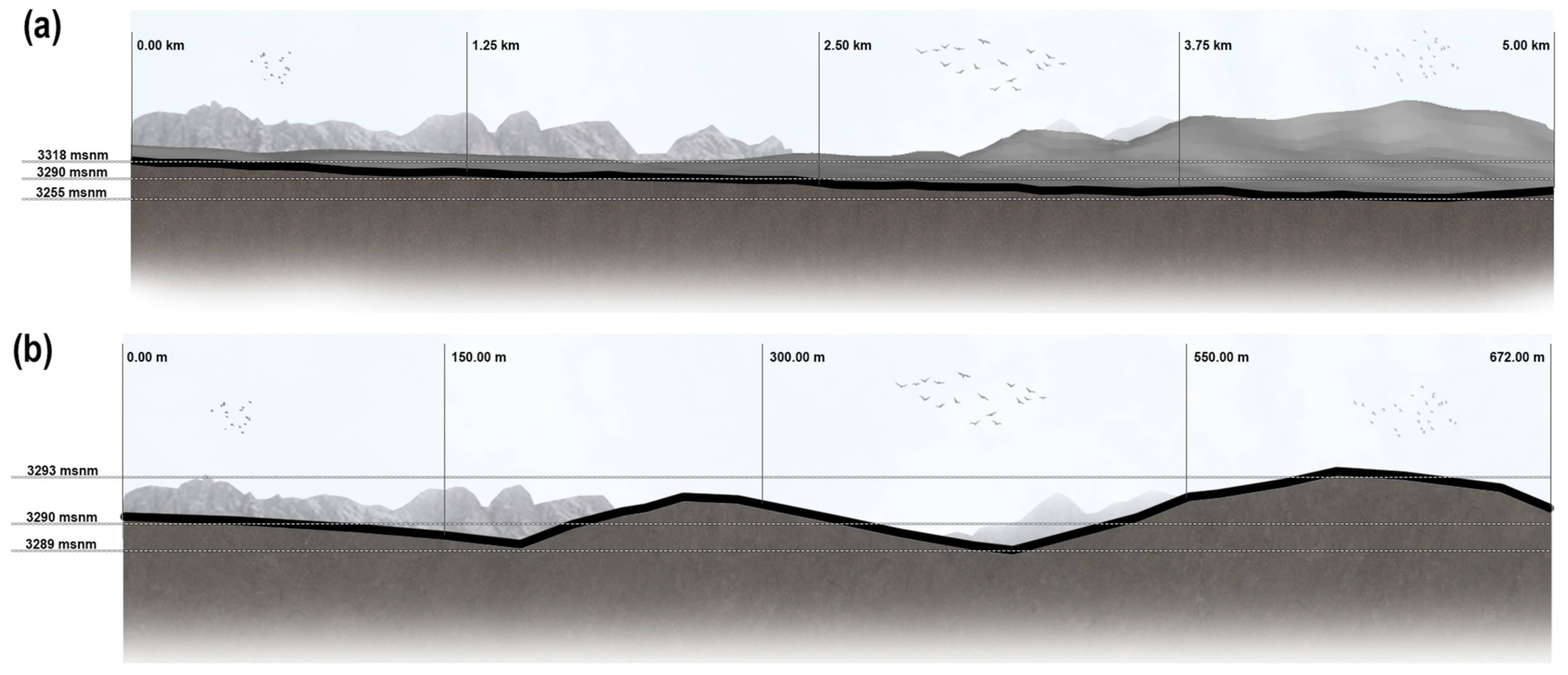
The chosen site for this project is located where the Velazco Astete International Airport currently stands. In terms of feasibility, it features two important avenues, the Expressway and Velazco Astete Avenue, is easily accessible, and has an area of 120 hectares. The terrain has a rectangular shape with almost flat topography, with a 50 m difference in elevation over a length of 7.8 km.
In Figure 12, the location of the terrain at the current Alejandro Velasco Astete International Airport can be observed. This airport is the second most important in Peru as it serves as the main entry point for visitors to the ruins of Machu Picchu. It has an extension of 3.8 × 1 km2, and a total perimeter of 8780 m. Situated in the urban core of the city of Cuzco, between the districts of San Sebastian and Wanchaq, it is 3.7 km from the imperial city [43] and 2 km south of the Central Plaza, surrounded by a medium-density residential area. The altitude of the airport terminal is 3247 m above sea level [44].
In Figure 13a, the longitudinal section runs from east to west in a descending manner, with a maximum point of 3533 m above sea level, depicting a terrain that is not very rugged and exhibiting a slope of 10% from corner to corner, equating to a difference of 28 m between each point. Meanwhile, Figure 13b illustrates the transversal section of the terrain, which runs from north to south, revealing a rugged terrain, which indicates that the area where the Velasco Astete airport is located is not flat, with a difference of 4 m between the highest and lowest points of the geographical section.

3.2. Conceptualization

This project is based on 3 interconnected concepts which relate to each other, contributing different characteristics such as hierarchy, solids and voids, the use of angles, and astronomical orientation. One of these concepts is that of ‘pachamama’, understood as Mother Earth in Andean cosmology. It provides a spiritual dimension that guides planning and respect for the natural environment, advocating for sustainable resource utilization. It embraces the irregular form of its symbolism along with its representation of land and agriculture [45]. The concept of ‘terraced fields’ was also utilized to generate different hierarchies among various spaces and sectors of the project, forming an integral part of the Andean cultural landscape while considering diverse ecosystems and their climatological particularities [46]. Finally, the system of ‘ceques’, which consists of a set of lines or directions projected from the Temple of the Sun in the city of Cuzco and which had the function of organizing, will be used to connect significant places, such as the main historical and cultural buildings of the project, weaving a conceptual network that links Andean history, nature, and spirituality in the project’s design. This allows for the radial organization of urban planning for the green corridor [47].

3.3. Master Plan Proposal

A green corridor with a systemic/sustainable approach is proposed to positively impact the city’s carbon footprint, given the significant pollution from both illegal mining and the neglect and poor management of rivers. Additionally, the land is divided into three zones: cultural, convention center, and botanical garden. The importance of the botanical garden is emphasized, as its use of renewable energies such as biodigesters (biogas) makes it a self-sustaining space.
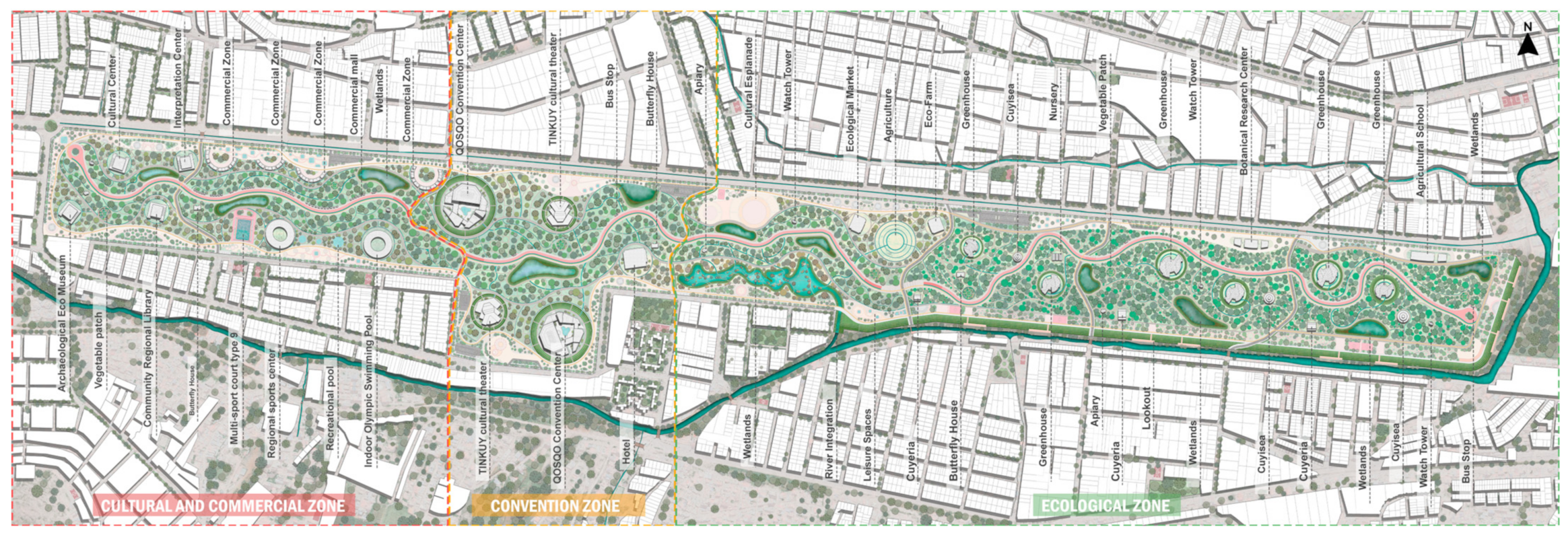
In Figure 14, the design of the masterplan located on the terrain of the Velasco Astete International Airport can be observed, and zoning by different areas is appreciated.
Historical Zone: Bounded by segmented red lines, this area encompasses sector 1, where the commercial axis begins, and the mirabus route crosses the entire project horizontally (represented by a continuous red line), featuring facilities dedicated to education as well as plazas. In sector 2, there are facilities focused on interpretation, user recreation, and small commercial areas.
Cultural Zone: Framed by yellow lines, this zone is designated as sector 3, highlighting it as the main nucleus of the project. In this sector, emblematic buildings such as the QOSQO Convention Center and the Tinkuy Cultural Theater are erected. It also includes a 4-star hotel designed to accommodate international guests visiting these structures or arriving for conferences or other international events.
Bioclimatic Zone: It is divided into two subzones. In sector 4, the project’s biologist is located, responsible for filtration for the purification and rehabilitation of the Huatanay River. Additionally, this process is utilized for irrigating green areas and maintaining the botanical garden, which spans from sector 5 to 7, the latter being the final sector of the project. This botanical garden maintenance system also involves the use of “cuyiseas”, which provide fertilizer and energy for the facilities. These “cuyiseas” are located in these last three sectors, which include a promenade featuring a circuit of viewpoints to take advantage of the view of the new and rehabilitated Huatanay River.

3.3.1. Urban Design Strategies

The design of the green corridor was based on various strategies considering the current issues of the city of Cuzco along with the city’s morphology, generating integrations of internal roadways based on street connectivity, zoning considering conceptualization and deficits in certain sectors, the implementation of urban retreat, urban and internal nodes, etc. (Figure 15).
This figure provides a more detailed view of the parts of the masterplan design located on the terrain of the Velasco Astete International Airport. It outlines the stages of design and the concept behind each:
Urban Nodes: At the intersections of the most important roads, nodes are generated, which, when incorporated into the project, create entrances or potential pathways.
Internal Nodes: The different internal uses generate nodes, which require treatment and distribution as part of the masterplan.
Internal Roadways: Through the generated nodes, internal roadways are projected, which are for vehicular and pedestrian use.
Urban Retreat: As a means of integrating the project/urban area, the projection of setbacks in the entire perimeter of the project is proposed, thus creating a relationship between the two elements.
Green Corridor: Once setbacks are projected, a central space is generated in the project, which is planned as a green corridor, functioning as the axis of the proposal.
Zoning: Just as spaces were segmented by hierarchy in the Inca era, the proposal seeks the division of three large spaces that present different uses but are interrelated.
Alternative Transport: As an alternative means of transportation, a bus line is proposed to operate within the longitudinal axis of the project, as there is a goal to reduce private transportation.

3.3.2. Proposed Spaces

(a)
Urban Retreat
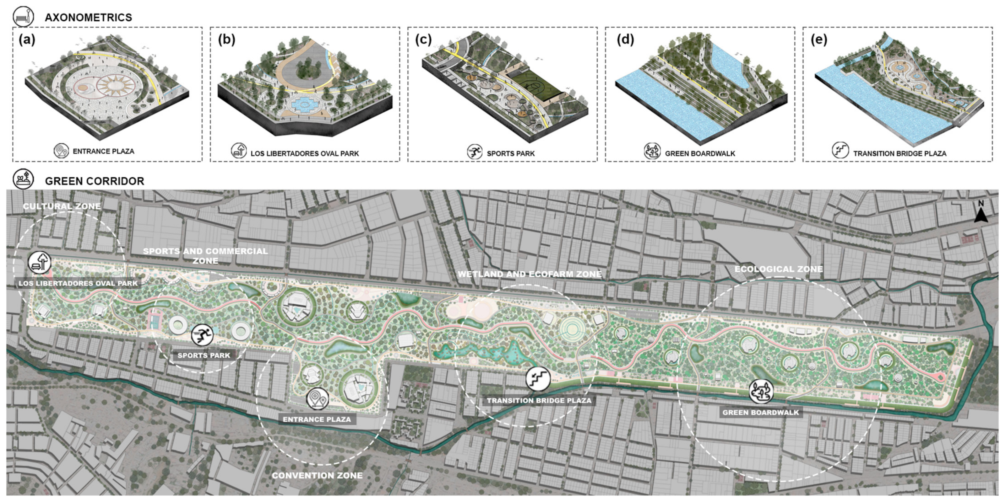
An integral design of an urban retreat is proposed along the edge of the terrain. This includes three-dimensional representations of the promenade with climate-adapted trees, the plaza located on the transition bridge, the park called “Oval of the Liberators”, the plaza serving as the entrance to the green corridor, and the area designated for sports activities.
In Figure 16, the axonometry of the Entrance Plaza to the Green Corridor (Figure 16a) can be observed, which covers a total area of 5744 m2, with 1087 m2 reserved for green areas. In this visual representation, the strategic arrangement of elements such as planters with trees is evident, which not only adds aesthetic value but also provides shade to the users of Cuzco. The plaza serves not only as the main access to the green corridor and the convention center but also as a node of activities, providing opportunities for community interaction, highlighting innovation through the inclusion of photovoltaic tiles, harmoniously integrating sustainability by harnessing solar energy.
Additionally, the axonometry of the “Oval of the Liberators” park (Figure 16b) is observed, which covers a total area of 1910 m2, with 350 m2 reserved for green areas and 255 m2 for the water fountain, which is the main element of this park. The combination of tile colors along with the strategic location of this park makes it a focal point that invites people to enter the green corridor, as it is located at the intersection of four important avenues of the city, such as the expressway, Av. Velasco Astete, Av. 28 de Julio, and Av. Qosco.
The sports park (Figure 16c) is located in the sports and commercial area, with a total area of 1955 m2 and green areas covering 432 m2. The main function of this park is to provide two areas with outdoor exercise machines, a space for meditation and yoga activities, and an exclusive area for calisthenics.
Finally, the tree-lined promenade (Figure 16d) and the transition bridge plaza (Figure 16e) are interconnected, as this transition plaza represents the pedestrian transfer from the wetland area to the botanical garden area, and this is where it integrates into the tree-lined promenade. The promenade runs along the entire botanical garden, facing the Huatanay River, covering an area of 35,506.69 m2 with a green area of 29,506.69 m2. The spaces that add significant value to this tree-lined promenade include four sports courts, ten viewpoints facing the Huatanay River, eight plazas for social interaction, and two cultural amphitheaters. On the other hand, the transition bridge plaza covers an area of 4800 m2, with a green area of 400 m2. This plaza provides spaces for contemplating the first glimpse of the Huatanay River and how it integrates into the green corridor through the creation of an artificial wetland, featuring a viewpoint, a cultural esplanade, and three water fountains.
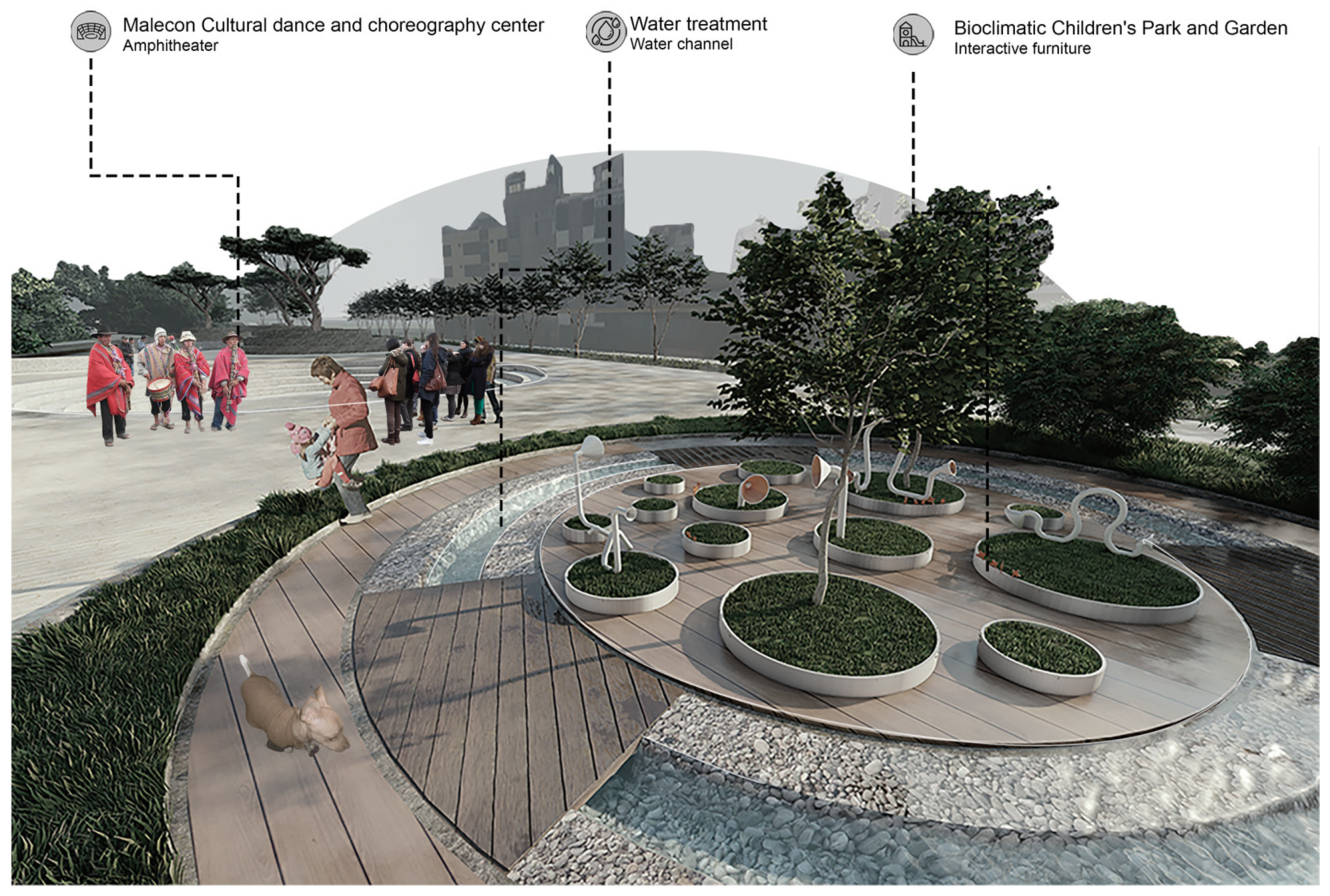
In Figure 17, the promenade of the dance and cultural choreography center can be observed, which is also part of the extensive urban retreat of the green corridor. It covers an area of 4100 m2 with 600 m2 of green areas. The spaces within this promenade include four amphitheaters for choreography exhibitions and artistic practices, two parks that include urban furniture and irrigation channels for the plants on the promenade, and ten seats with planters that provide shade to the users of Cuzco.
(b)
Botanical Garden
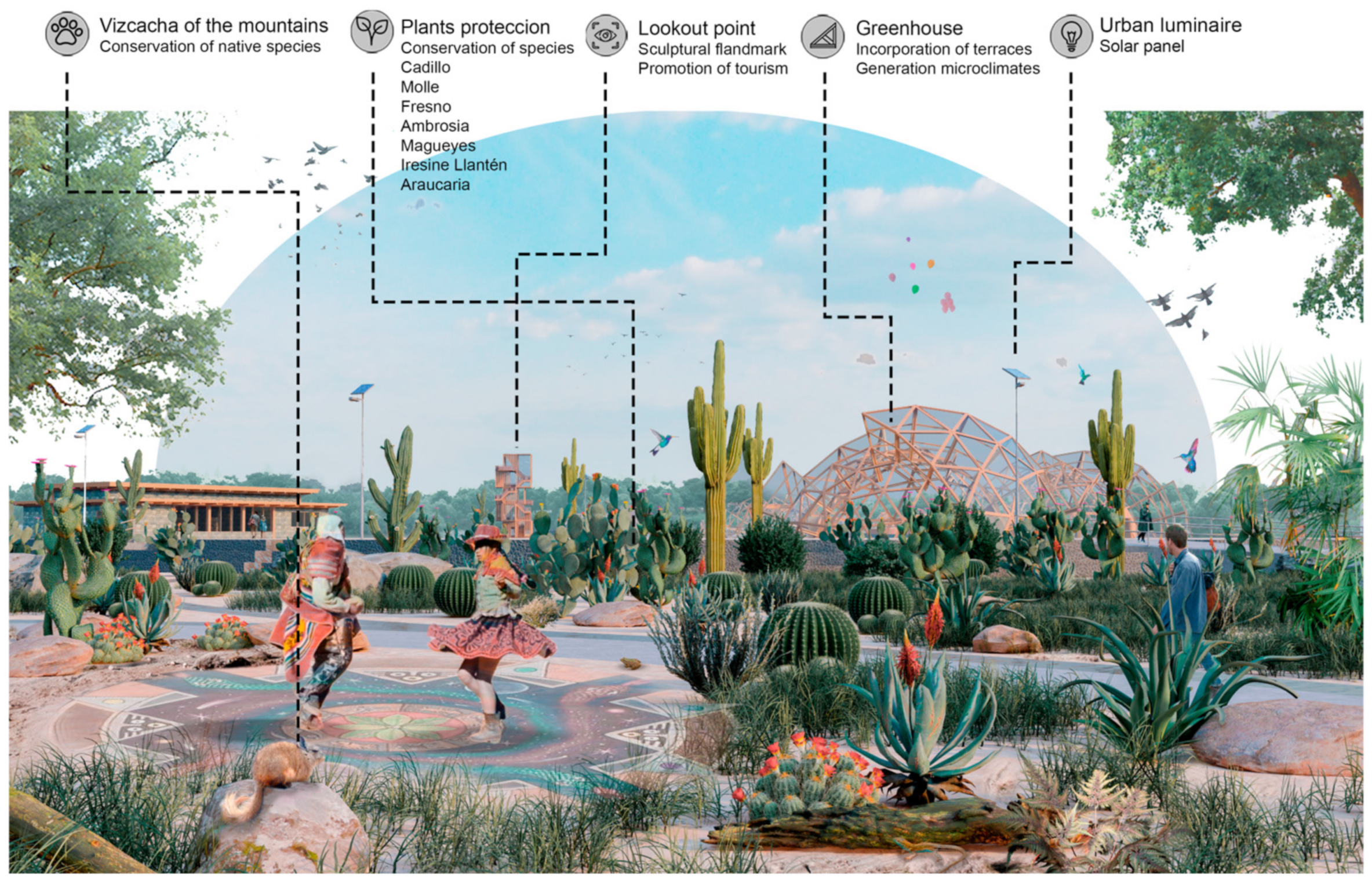
The design of the botanical garden in Cuzco is carried out with the intention of promoting the conservation of plant genetic resources, controlling the destruction of plant diversity, and providing education at various levels, while valuing the natural richness of the Cuzco region [48]. The botanical garden promotes the conservation of various plant species such as Cadillo, Molle, Fresno, Ambrosia, and Magueyes, among others. Additionally, there is an aim to address the planning of public space around the botanical garden in a way that both functions (public and private use) have a positive impact on social, environmental, and economic aspects in the surrounding area.
Figure 18 depicts the area of the botanical garden within the green corridor, offering a comprehensive view of a sustainable and multifunctional space. It covers an area of 232,146 m2, representing almost 18.14% of the terrain. Six greenhouses are highlighted, with areas ranging from 1661 m2 to 2463 m2 each, located 4 m below the level of the green corridor, as shown in the master plan. Beyond their conventional architectural function, the greenhouses play a fundamental role by incorporating the concept of “terraced fields” for the generation of a favorable microclimate, significantly impacting the thermal regulation of the interior environment of the greenhouses [49].
Additionally, space is allocated for nurseries (771 m2), three areas for urban gardens (452 m2 each), and three areas for biogas production (659 m2 each), using guinea pig excrement as raw material. This initiative not only aims to generate energy for lighting poles and restaurants within the garden but also produces biol as fertilizer, thus promoting sustainability [50].
In the educational framework, the figure includes buildings dedicated to the Botanical Research Center and an Agricultural and Ethnobotanical School, emphasizing the importance of education and scientific research in botany, biology, and ecology. This approach is further enriched by considering the information provided by INGEMMET (Geological, Mining, and Metallurgical Institute) and its National Vegetation Cover Map [51], since they become an essential tool for the selection of species, prioritizing those that require protection and conservation such as Cadillo (Cenchrus echinatus), Molle (Schinus molle), Fresno (Fraxinus), Ambrosia (Ambrosia peruviana), Magueyes (Agave americana), Iresine (Iresine herbstii), Llantén (Plantago major), and Araucaria (Araucaria araucana).
(c)
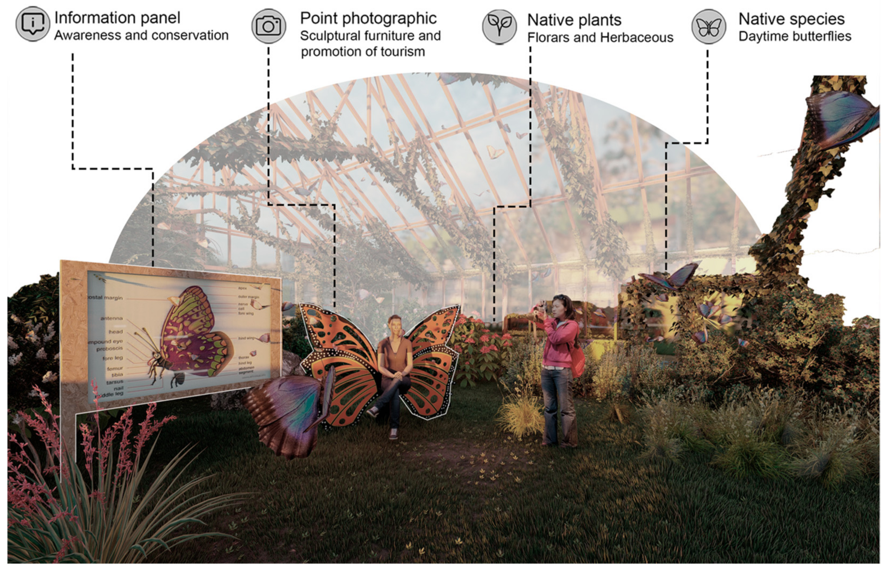
Butterfly House
Peru harbors 70% of the world’s biological diversity, highlighted by its position as the country with the highest number of species of diurnal butterflies in the world, totaling close to 4000 species [52]. That is why it is optimal to implement a butterfly house in the green corridor for the intensive production and conservation of butterflies, where live adults are obtained from early stages or early stages are produced from adults capable of continuing to reproduce in perfect condition in a controlled environment. This promotes the sustainability of biodiversity through research, training, and education, always seeking a balance between conservation and sustainable development [53].
Figure 19 highlights the presence of strategically distributed butterfly houses along the green corridor, with a total of three. These butterfly houses, covering an area of 175 m2 each, will initially house 220 butterflies classified into six different species: Morpho helenor, Heliconius doris, Phoebis philea, Caligo ilioneus, Battus polydamas, and Consul fabius.
As the project develops, a gradual increase in the number of species is expected, thus contributing to the diversification of the environment. Additionally, this space not only aims to be a sanctuary for butterflies but also an educational and environmental awareness tool for the population of Cuzco, strengthening their connection with the environment and promoting local identity through conservation and awareness panels, sculptural furniture, and photographic spots.
The butterfly house will also highlight the importance of host plants present in its environment. Among the included plant species are Aristolochia sp., Piper sp., Cassia sp., Senna elata, Asclepias sp., Passiflora auriculata, and Musa sp., among others. These host plants not only serve as landscape elements but they also provide the necessary habitat for the reproduction and development of butterflies, thus reinforcing the interrelationship between the flora and fauna of Cuzco [54].
(d)
Viewing Tower
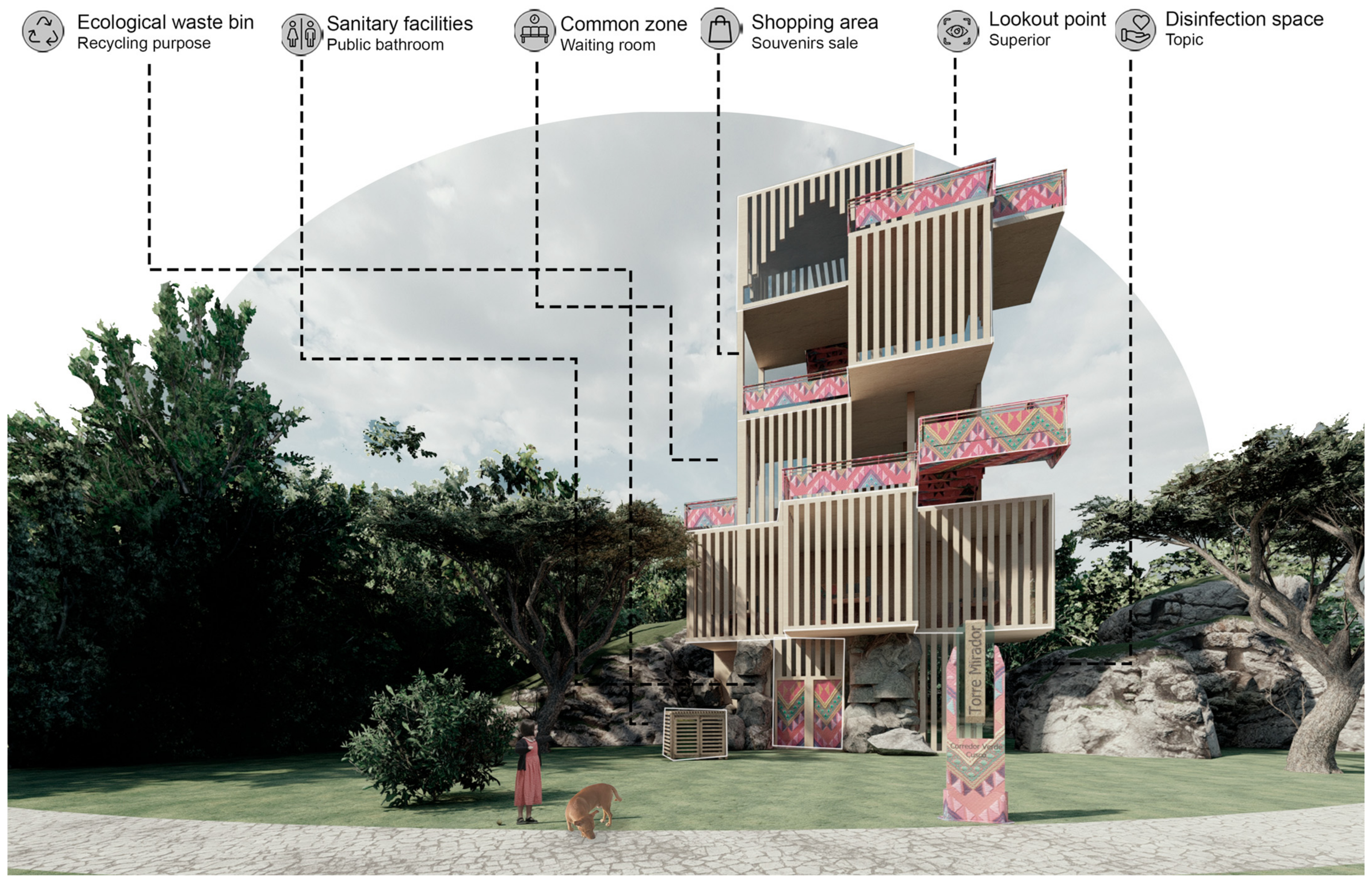
In addition to being a recreational spot for the residents of Cuzco, the viewing tower serves as an attraction for visitors, promoting the creation of public spaces in areas of the green corridor that may not have been fully utilized. The tower also provides amenities for visitors, such as resting areas, common zones, disinfection areas, and spaces for souvenir sales.
Figure 20 depicts the incorporation of viewing towers along the green corridor. These structures, each with an area of 100 m2, will be strategically distributed in six specific points of the terrain, allowing visitors to fully enjoy the landscape and various areas of the green corridor. Each viewing tower, with a height of 20 m and five floors of 4 m each, features a functional layout that addresses current needs.
In response to the COVID-19 pandemic, the ground floors of these towers will house disinfection spaces, sanitary services, and ecological containers to promote recycling practices. The intermediate floors will offer common resting areas and zones designated for local commerce, while the upper floors will be exclusively reserved as observation decks, providing unique experiences for appreciating the surroundings.
The choice of the “platform-based viewpoint” typology is justified by its effectiveness in flat terrain with visual obstacles, providing the necessary height to establish strategic observation points [55]. Additionally, these viewing towers conceived as public spaces not only offer improved opportunities for detailed observation of urban and natural landscapes but also significantly contribute to Cuzco’s tourism offerings.
(e)
Urban Gardens
The incorporation of urban gardens in the green corridor is an effective way to promote sustainability, community, and connection with nature. Additionally, the design of urban gardens accessible to people of all ages and abilities includes accessible pathways, resting areas, and raised beds to facilitate participation for all.
Sustainable gardening practices are integrated, such as efficient water use, composting, and the selection of crops that adapt to the local climate.
Figure 21 displays the urban gardens, which consist of seven cultivation spaces distributed along the green corridor, each covering an area of 600 m2. These urban gardens are established as small-scale crops adopting less intensive practices and encompassing mixed activities to ensure their sustainability. Various native foods of Peru will be planted in these urban gardens, including cereals, legumes, vegetables, and fruits emblematic for consumption in Cuzco, such as Maize, Quinoa, Qañihua, Kiwicha, Achis, Magu, Cazza, Beans, Pallares, Porotos, Pashuru, Tarwi, Achupalla, Awaimantu, Airampo, Akhana, Api-Tara, Caiguas, and Qochayuyo, among others [56]. These foods will be organically fertilized by the Biol produced by the cuyisea, which is a nutritional supplement that increases the natural fertility of the soil without contaminating water, air, or the products obtained [57].
Beyond their agricultural function, these urban gardens will have a positive impact on the communities of Cuzco, as they include sustainable production systems and present environmentally friendly characteristics, thus revitalizing public spaces and generating a productive landscape that contributes to various aspects of Cusco’s society. This sustainable approach harnesses the gaps in the green corridor to foster identity and a sense of belonging to the locality of Cuzco [58].
Beyond the environmental impact, they will also have an economic impact by offering additional sources of income, thus improving the dietary quality of families in Cuzco. Additionally, they play a crucial role in promoting education, developing social relationships, and reintegrating individuals into society and the productive sector. Thus, the implementation of urban gardens emerges as a multifaceted strategy that not only benefits food security but also contributes to the socio-economic and cultural development of the Cusco community [59].
(f)
Eco-farm
The eco-farm is an alternative that will allow users to learn about sustainable management through experiential learning in the interactive farm, composting center, and bio-gardens. In this space, visitors can interact with domestic animals, learn in a playful way about proper organic waste management, and participate in experiential workshops on plants. Additionally, they can learn about new alternatives such as hydroponics and aquaponics [60].
In Figure 22, the presence of an eco-farm is highlighted, covering an area of 2500 m2. This space is conceived as an educational center where the community of Cuzco can participate in various activities aimed at fostering knowledge and connection with nature. These activities include educational experiences with farm animals, teaching cultivation techniques in the bio-garden, understanding the functions of the nursery and composting, and providing instruction on the use of compost for a bio-garden.
In addition to its educational function, the eco-farm will house a variety of animals, from cows and calves to rabbits, guinea pigs, donkeys, alpacas, llamas, vicuñas, and horses. Following the model of urban gardens, agriculture will continue to be a priority on the eco-farm, but this time it will be implemented using terraced cultivation, taking advantage of a traditional and efficient terrace farming technique that has been used ancestrally in Cuzco.
The fundamental objective of the eco-farm is to apply the principles of permaculture and its ethics, inspiring a collective desire to adopt life alternatives aligned with harmonious coexistence with nature. Finally, through practical education and exposure to sustainable agricultural activities, the eco-farm will become a vital space for community development in Cuzco [61].
(g)
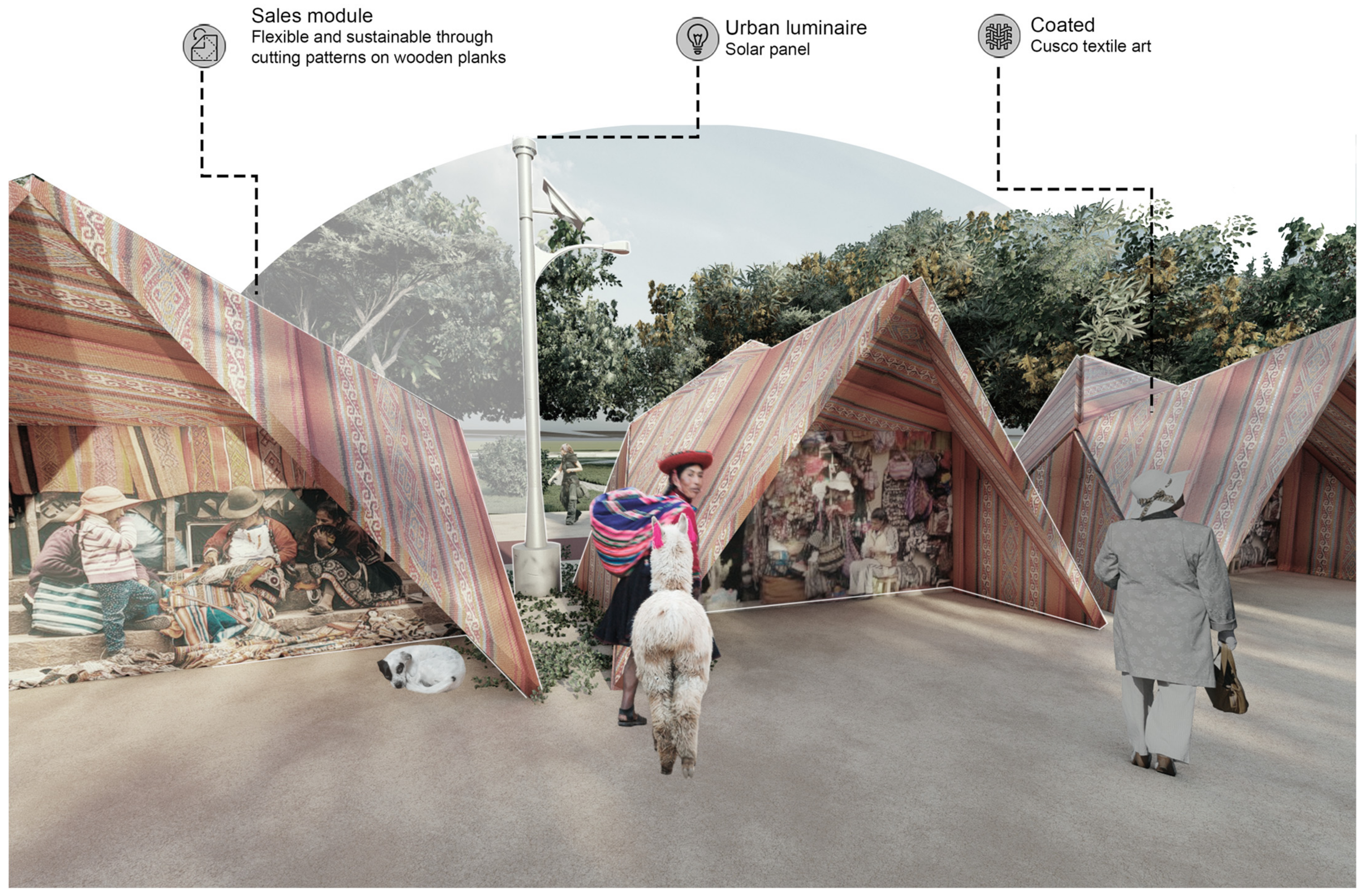
Commerce Modules
The inclusion of commercial spaces in the social housing project serves as a beneficial strategy to enhance the residents’ quality of life and foster the economic sustainability of the community.
Figure 23 showcases the commerce modules, comprising 38 units, each with an area of 20 m2, distributed along the cultural and commercial zone, specifically in the second stretch facing the tour bus lane. Each of these modules is designed by cutting patterns on a surface to provide greater flexibility, thus developing a new sustainable method that is easily adaptable to the environment. They are user-friendly as they require no assembly and will be covered by characteristic weavings from the city of Cuzco, produced by the same merchants of the green corridor.
These modules stand out for their architectural versatility, offering a broader creative and constructive solution. Their flexibility allows for reassessment and reconstruction with improvements and less waste if necessary, and even the possibility of being dismantled, thus reclaiming the land and respecting the surrounding landscape. Compared to conventional architecture, this approach tends to reduce costs due to the manufacturing process in a workshop, thereby reducing pollution and ecological impact [62].
(h)
Bus tour and Bike Lane
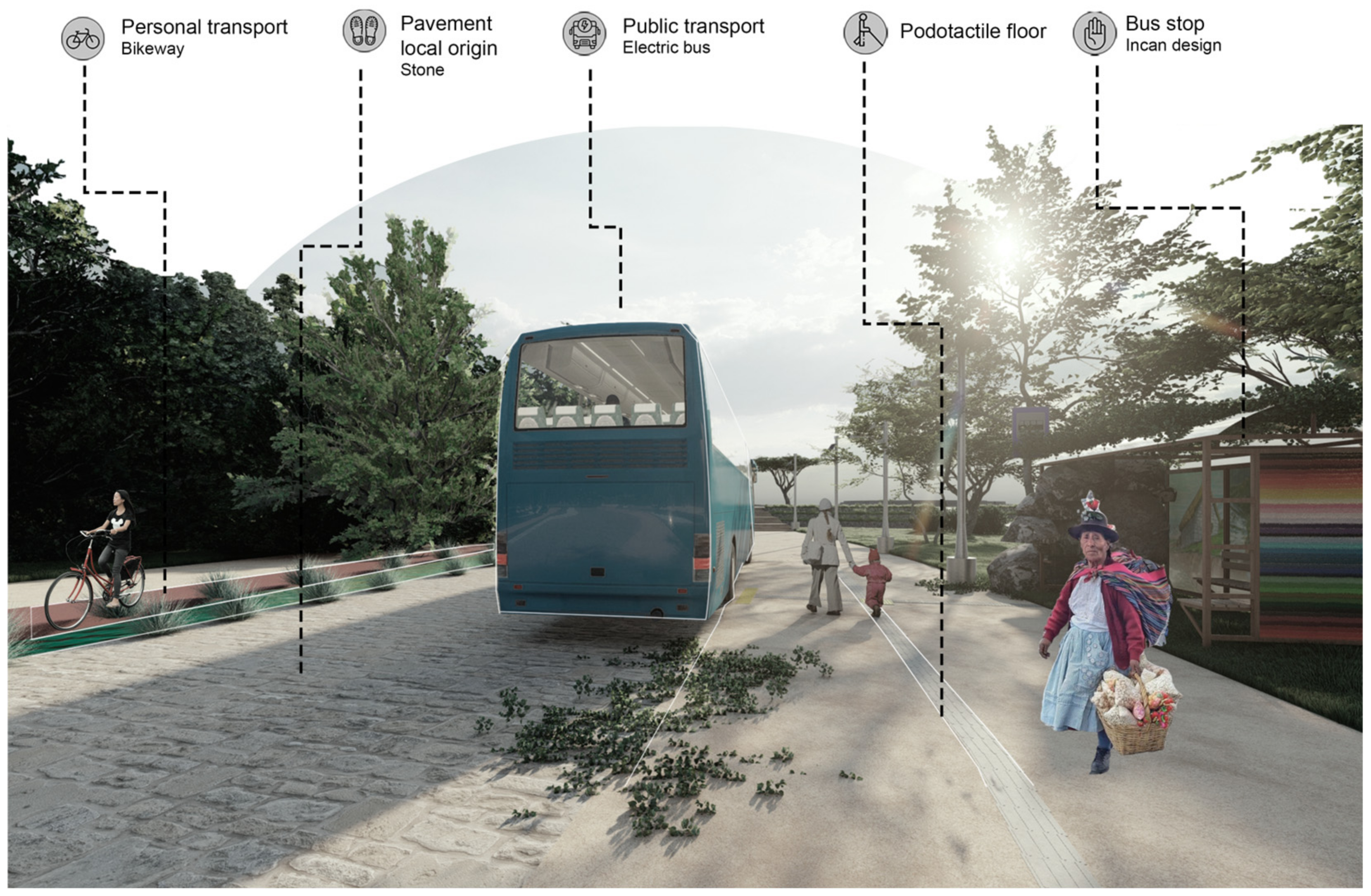
The combination of electric bus services and bike lanes that run through all sectors of the green corridor functions as an integrated strategy to promote sustainable mobility and improve transportation infrastructure in an urban environment.
Figure 24 shows the implementation of the bus tour and the cycle path as fundamental components of the project. The cycle path, with a width of 2 m and an extension of 15 km that will cover the entire green corridor, and the bus tour, with a width of 7 m and a route of 5 km from end to end of the corridor, are designed to offer sustainable and accessible transportation alternatives for the entire community. In addition, 13 bus stops, with an area of 50 m2 each, have been strategically established in the project, ensuring that all people have easy access to the bus stop from various sectors.
The incorporation of cycle paths not only promotes improved health due to the physical effort required for riding a bicycle, but also contributes significantly to the reduction in carbon dioxide by avoiding the use of motorized vehicles [63]. On the other hand, the tour bus responds to the active search to mitigate greenhouse gas emissions in Cusco. By running on stored energy, independent of fossil fuel, this transportation system is not only efficient, but is also environmentally friendly, avoiding air pollution [64]. The combination of the cycle path and the tour bus promotes sustainable mobility and the preservation of the environment in the green corridor.

3.4. Applied Design Strategies

3.4.1. Sewage Treatment

Wastewater is understood as water that has been manipulated to such an extent that its consumption is harmful to the average human; its is mostly used in activities of low risk, such as industrial, domestic, and municipal [65]. Its treatment is of vital importance in the proposed green corridor, as it is a constant water source. The use of non-conventional methods such as artificial wetlands and filtration channels is planned in order to enhance the river in an economical and sustainable manner.
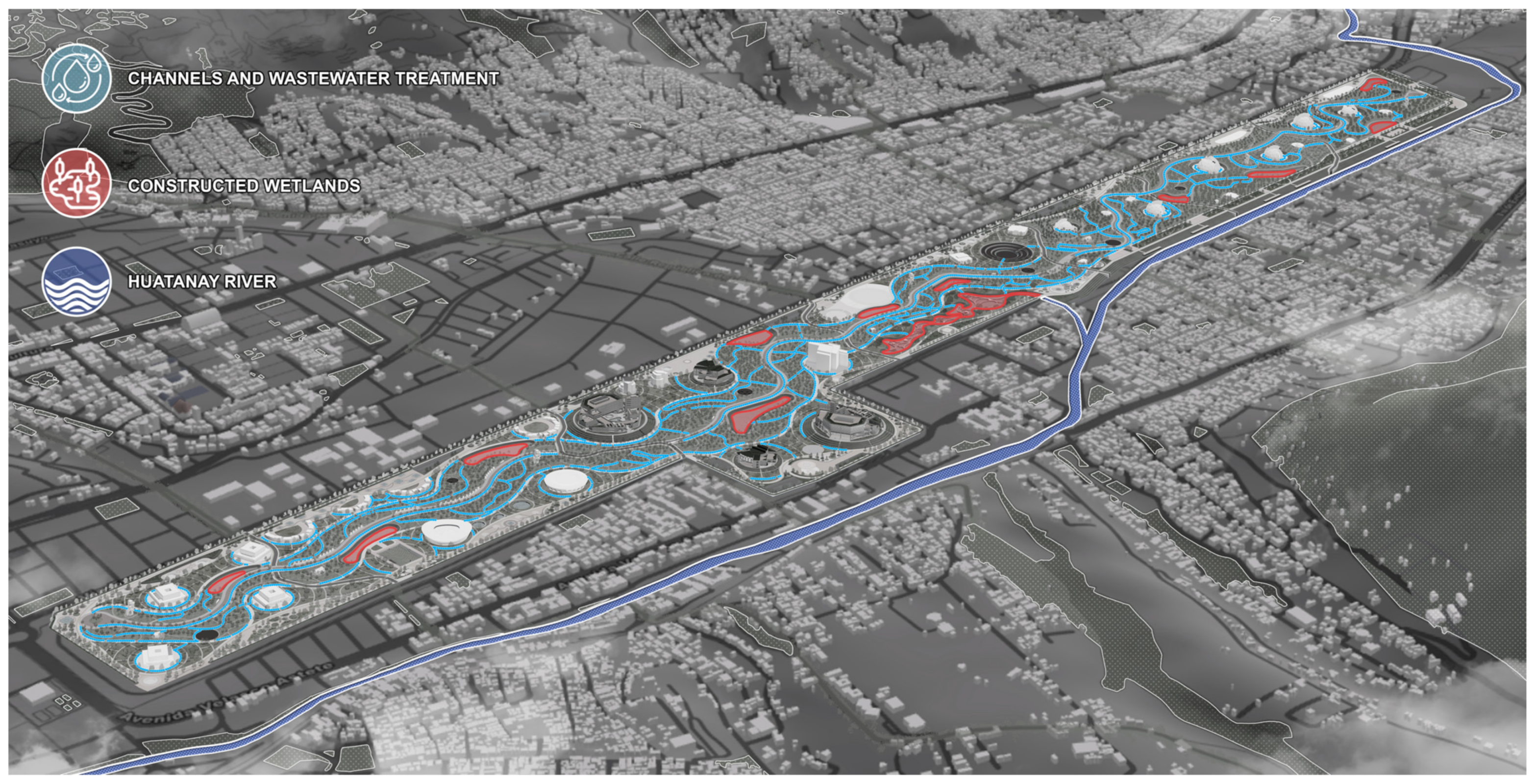
Figure 25 highlights the implementation of the sustainable urban drainage system in the project, represented by light blue channels that run throughout the green corridor. These channels, with a length of 2105 m2 per section, have a total of 21,287.671 m2 throughout the corridor; moreover, they are essential for filtering and treating the waters not only of the corridor itself but also of the surrounding areas, including commercial, cultural, sports, and botanical facilities. The importance of this lies in their ability to improve water quality due to the implementation of a filtration system that helps optimize irrigation performance in each of the green areas of each facility by removing sediments and undesirable particles [66].
In addition to Figure 25, the 12 artificial wetlands distributed throughout each sector of the green corridor are highlighted in red. With areas ranging from 1139.64 m2 to the largest with 12,817.24 m2, they together total 35,976.96 m2, representing almost 3% of the entirety of the green corridor. These surface flow artificial wetlands, with a depth of 0.5 m, play a vital role in water management, contributing to ecosystem preservation and the recovery of wastewater from the Huatanay River.
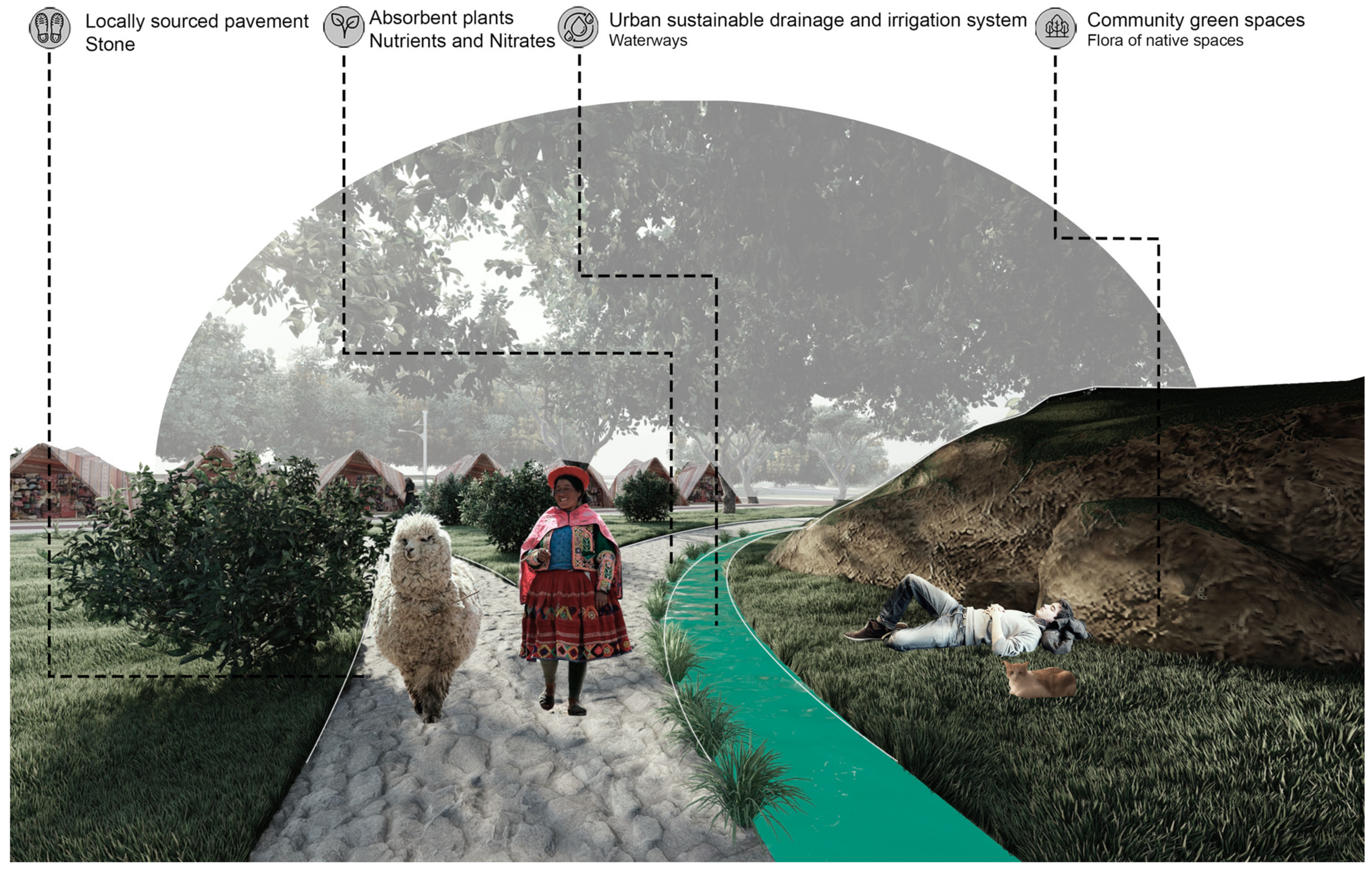
Figure 26 presents the sustainable urban drainage system, inspired primarily by the Inca irrigation canals of Tipón. This Inca system was constructed based on hundreds of walls, terraces, and corridors, made of carved stone to serve as irrigation conduits [67]. The channels in Figure 24 have a width of 1 m to 2 m, and the purpose of this is to reduce surface runoff to avoid the concentration of large volumes of water at a specific point. To achieve this, drainage is directed towards the green areas of the green corridor, emulating the Inca irrigation system. Additionally, the reuse of captured water for irrigation is proposed, thus providing a double benefit by saving water resources [68]. As this system is a green infrastructure, it requires the use of vegetation, particularly emergent macrophytes such as Scirpus lacustris, Phragmites australis, and Typha latifolia, plants that grow submerged in water with the water table at approximately 0.5 m below the surface [69]. These species play a key role in regulating stormwater and reinforce the sustainable approach of the drainage system.
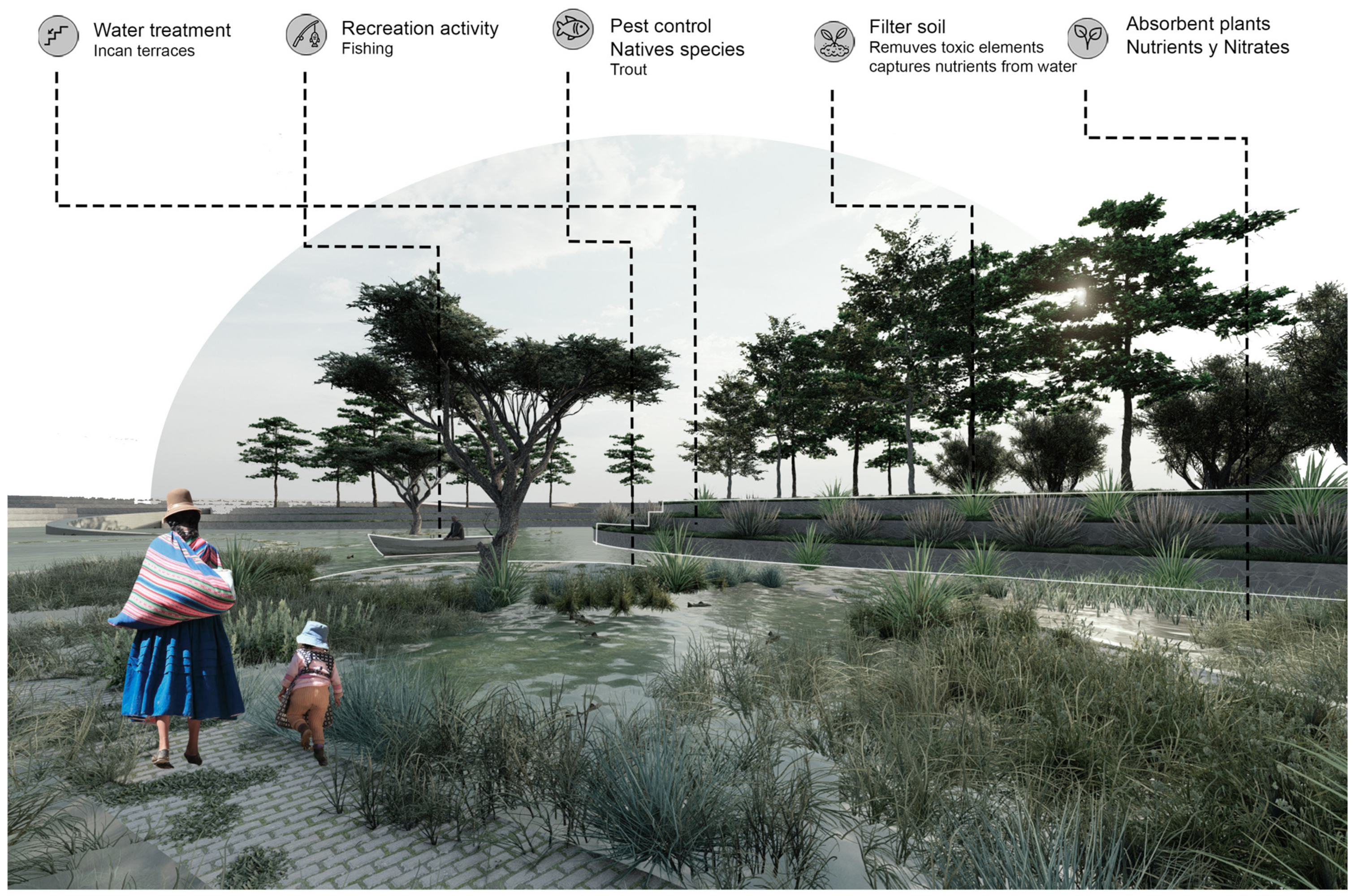
In Figure 27, the biofilters implemented in the artificial wetlands are depicted, configured as basins or excavated trenches filled with porous materials that act as a filtering medium and as a growing medium for planted vegetation. These biofilters must have good filtering properties, contaminant absorption capacity, and the ability to transform contaminants through the interaction of plants and associated microorganisms. This approach allows for the removal of a variety of contaminants, such as the simultaneous removal of organic matter, nitrogen, and phosphorus, thus contributing to the environmental quality of the green corridor [70,71].
The plants selected for the biofilters include emergent macrophytes, floating-leaved macrophytes, floating macrophytes, and submerged macrophytes, all present in the typology of surface flow artificial wetlands. Among these plants are Scirpus lacustris, Phragmites australis, Typha latifolia, Nymphaea alba, Potamogeton gramineus, Hydrocotyle vulgaris, Lemna minor, Eichhornia crassipes, Potamogeton crispus, and Littorella uniflora, each playing a crucial role in the water purification process [72].

3.4.2. Incan Terraces

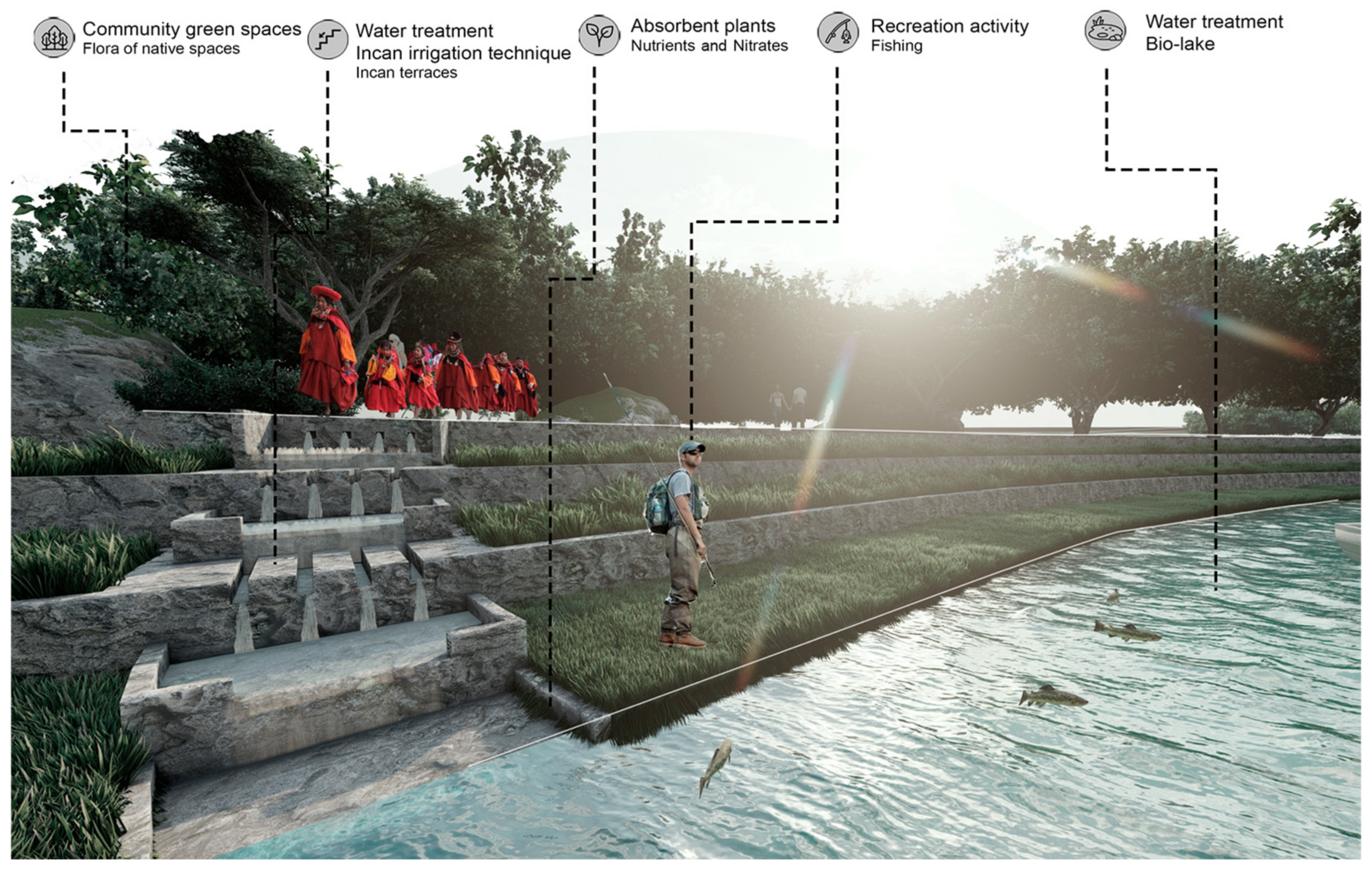
These terraces are directly inspired by the Moray terraces, which counteract erosion with their inclined retaining walls, distribution, and retention of moisture, while also facilitating drainage [73]. Within the project, it is intended for these terraces to be part of a network of greenhouses and butterfly gardens, aiming to create different microclimates to accommodate species that cannot adapt to the surrounding climate.
Figure 28 depicts the construction method of terraces located in the project, inspired by the Moray area, which served as a center for agricultural research but also had significant functions in Inca politics and religion [74]. These terraces, with an initial height of 1 m, progressively step up to reach heights of 3 to 5 m. This design is replicated in different areas of the project, including artificial wetlands, greenhouses, and the observation areas facing the Huatanay River. On the other hand, in the convention area, the terraces grow up to 1.5 m high and step up to 6 m in height, aiming to highlight the presence of the convention center buildings and the cultural theater. It is noteworthy that these terraces in the convention area rise above ground level, in contrast to the terraces in other areas, which adapt to the site’s topography, thus creating a distinctive element in the project’s landscape design.

3.4.3. Bamboo Farm

The inclusion of a bamboo farm in the project arises as a beneficial strategy to improve the quality of constructions and promote environmental sustainability in the green corridor.
In Figure 29, the area designated for bamboo farms is located next to the tree-lined promenade along the Huatanay River, covering an area of 18,982 m2. In this space, farms will cultivate the native bamboo species, Guadua angustifolia, also known as Guayaquil cane [75]. This species naturally grows at an altitude of 2000 m above sea level, making the farm’s location ideal, considering that Cusco is situated at an altitude of 3399 m above sea level [76].
Guadua angustifolia will be used in construction due to its notable physical properties, such as strength, flexibility, and lightness. This bamboo is recognized as “vegetable steel” [77]. These characteristics are fundamental in the design of earthquake-resistant constructions, including the farms intended for sustainable bamboo production.

3.4.4. Material

The chosen construction system is wood framing in dry construction, which is an open construction model where materials do not require wet additives for the realization of their structures. Other models include drywall and steel framing. It can be simplified as a set of blocks that fit together, generating spaces or modules that easily fit together. This presents advantages such as reduced construction times and labor, as well as a reduced carbon footprint [78].

4. Discussion

The global discussion on compact cities addresses the complexity of urban planning, particularly regarding the insufficient provision of green spaces due to rapid population growth. This situation results in a deficit of square meters of green space per person, posing challenges to the well-being and quality of life of urban residents. In response, research focuses on generating innovative solutions to address the growing demand for green spaces in a context of urban expansion that exceeds the development capacity of such areas. The bidirectional filtration system, SUTRANE, proposed in Mexico, demonstrates an innovative approach to addressing water management challenges in urban areas. Utilizing both anaerobic biodegradation and conventional filtration, this system successfully purifies water in abandoned areas near a lake, crucial for ensuring access to clean and safe water. This integrated filtration approach not only enhances water quality but also helps optimize water consumption in these areas, thus contributing to environmental sustainability and community well-being. Additionally, the implementation of sustainable urban drainage systems in the project highlights the importance of efficient water management in urban environments. The blue channels running through the green corridor not only serve to filter and treat water from surrounding areas but also improve the quality of water used for irrigating green spaces. Furthermore, the presence of twelve artificial wetlands distributed along the green corridor represents an effective strategy for water management, contributing to the preservation of local ecosystems and the recovery of wastewater, especially from the Huatanay River. These initiatives demonstrate how the integration of water treatment technologies can be fundamental in ensuring environmental sustainability and urban resilience in the context of accelerated urban development.
The Interpretation Center for the Valorization of Flora and Fauna in Cuzco, Peru, proposes an interpretation center as part of an urban proposal that designates 51% of the total land area as green space, incorporating a series of urban strategies aimed at ecology and self-sustainable change. It addresses topics such as the use of local materials, water reuse, and comfort, enabling them to propose an environmentally friendly project. The urban proposal stands out for its variety of public spaces and its focus on preserving the Huatanay River. A canal is implemented to act as a filter for river pollution, using oxidation ponds and wetlands, preserving endemic species and revaluing the river environment. Additionally, a residential area based on a circular economy model is integrated, with cultivation areas and greenhouses for food production, along with a commercial zone. On the other hand, the implementation of an ecogranja, which occupies an area of 2500 m2, is conceived as an educational center for the participation of the Cuzco community in various activities aimed at promoting knowledge of and connection with the natural environment. These activities include educational experiences with farm animals, teaching cultivation techniques in the bio-garden, understanding the functions of the nursery and composting, and instruction on compost use for bio-garden cultivation. In addition to its educational function, the ecogranja will host a variety of animals ranging from cows and calves to rabbits, guinea pigs, donkeys, alpacas, llamas, vicuñas, and horses. Inspired by urban gardens, agriculture will remain a priority in the ecogranja, but this time through terrace cultivation, leveraging a traditional and efficient technique that has been used ancestrally in Cuzco. The primary objective of the ecogranja is to apply the principles of permaculture and its ethics, fostering a collective interest in adopting lifestyles in harmony with nature. Ultimately, through practical education and exposure to sustainable agricultural activities, the ecogranja will become a vital space for community development in Cuzco. Peru harbors 70% of the world’s biological diversity, highlighting its position as the country with the highest number of diurnal butterfly species in the world, totaling around 4000 species. Therefore, it is optimal to implement a butterfly house in the green corridor for the intensive production and conservation of butterflies, where live adults from early stages are obtained or early stages are produced from adults capable of reproducing themselves in perfect conditions in a controlled environment. Likewise, this proposal exhibits the strategic location of three butterfly houses along the green corridor, each with an area of 175 m2 and an initial capacity of 220 butterflies belonging to six different species. A gradual increase in the number of species is projected as the project progresses, contributing to ecosystem diversification. These butterfly houses are conceived not only as shelters for butterflies but also as educational and environmental awareness tools for the Cuzco community. The aim is to strengthen the bond with the natural environment and promote local identity through the installation of informative panels, functional sculptures, and photographic points. Additionally, the importance of host plants in the butterfly house environment will be emphasized.
The proposed plan to address the integration of green spaces in compact cities, such as Cuzco, faces complex challenges, especially in historic environments. The green corridor proposal is presented as a fundamental strategy to overcome these difficulties, with the aim not only of integrating the city with nature but also of creating a space for social interaction. This approach is complemented by the implementation of advanced technologies such as biofilters and wetlands, designed to filter and revitalize the river, which has been affected by pollutants, especially from mining activity. Concern for the loss of local flora and fauna is addressed comprehensively in the green corridor proposal, which recognizes green areas as essential elements for the valorization of rivers and the restoration of ecosystems. This approach reflects a profound commitment to sustainability and environmental well-being, offering innovative technical solutions to improve the quality of the urban environment and promote harmony between the city and its natural surroundings.

5. Conclusions

Green corridors allow for the improvement of public spaces for the population and green areas for user connectivity through interrelated areas, as opposed to the notorious scarcity of green spaces. As a solution, a green element was proposed to not only be a public space but also to generate activities through its internal elements that relate the user to the city and nature. Likewise, local commerce activities were considered along the main axis of the land through a commercial promenade, generating the economic growth of local businesses and, therefore, of the city of Cuzco.
Through wastewater treatment, the aim was to revitalize one of the most important elements found in our immediate environment, the Huatanay River, which over the years has been neglected to the point of becoming a body of water where trash is dumped. Therefore, by incorporating ecological technologies such as biofilters and wetlands, the aim is to purify its waters and make them suitable for activities in the buildings or as a means of irrigation within the same green corridor.
Finally, through a green corridor, the aim is to counteract uncontrolled urban expansion and environmental degradation. This approach provides green spaces that allow for the development of the local flora and fauna and human connectivity with nature. It also allows for the preservation and restoration of local ecosystems, acting as a green lung in the city of Cuzco, contributing to the purification of air and water. Additionally, through these natural areas, biodiversity is encouraged, and the quality of life of citizens is improved by offering spaces for recreation and social interaction.

Author Contributions

Conceptualization, D.M. and S.R.; methodology, D.E. and V.V.; software, V.R.; validation, D.M., S.R. and D.E.; formal analysis, V.R.; investigation, D.M. and V.V.; resources, S.R. All authors have read and agreed to the published version of the manuscript.

Funding

This research received no external funding.

Data Availability Statement

All the data is in the manuscript.

Acknowledgments

We want to express our special thanks and appreciation to the colleagues who gave us the golden opportunity to carry out this wonderful project of Green Corridors and Social Connectivity with a Systemic/Sustainable Approach in the City of Cuzco, Peru-2023.

Conflicts of Interest

The authors declare no conflicts of interest.

References

  1. Artmann, M.; Inostroza, L.; Fan, P. Urban sprawl, compact urban development and green cities. How much do we know, how much do we agree? Ecol. Indic. 2019, 96, 3–9. [Google Scholar] [CrossRef]
  2. Lennon, M. Green space and the compact city: Planning issues for a ‘new normal’. Cities Health 2021, 5 (Suppl. S1), S212–S215. [Google Scholar] [CrossRef]
  3. Reyes Päcke, S.; Figueroa Aldunce, I.M. Distribución superficie y accesibilidad de las áreas verdes en Santiago de Chile. EURE. Rev. Latinoam. De Estud. Urbano Reg. 2020, 36, 89–110. [Google Scholar] [CrossRef]
  4. Du, M.; Zhang, X. Urban greening: A new paradox of economic or social sustainability? Land Use Policy 2020, 92, 104487. [Google Scholar] [CrossRef]
  5. Miranda, T.; Suset, A.; Cruz, A.; Machado, H.; Campos, M. El Desarrollo sostenible: Perspectivas y enfoques en una nueva época. Pastos Y Forrajes 2007, 30, 44–46. Available online: http://scielo.sld.cu/scielo.php?script=sci_arttext&pid=S0864-03942007000200001&lng=es&nrm=iso> (accessed on 20 June 2024).
  6. Sattele Gunther, V. El pensamiento sistémico para la vivienda sostenible en la Ciudad de México. Econ. Creat. 2019, 11, 8–37. [Google Scholar] [CrossRef]
  7. Hernández, J.R.H.; Fuentes, B.F.; Oviedo, J.A.-T. Enfoque sistémico como propuesta metodológica para el diseño de viviendas de interés social en estudiantes de arquitectura de la universidad de guayaquil. Opuntia Brava 2017, 9, 192–200. [Google Scholar]
  8. Redatam Development Centre. (s/f). INEI-REDATAM CENSOS 2017. Gob.pe. Available online: https://censos2017.inei.gob.pe/redatam/ (accessed on 24 June 2023).
  9. INEI. (s/f). Instituto Nacional de Estadistica e Informatica. Gob.pe. Available online: https://www.gob.pe/inei/ (accessed on 24 June 2023).
  10. Alfaro Aucca, C.; Corahua Ordoñez, J.; Cavero Hermoza, E.; Bernales Guzmán, Y.; Espetia Huamanga, H.; Pezúa Vásquez, R. Estudio del proceso de peatonalizacion de los ambientes urbanos en el Centro Historico del Cusco: Caso de la calle del medio(). Devenir 2023, 10, 133–152. [Google Scholar] [CrossRef]
  11. Núñez, S.; Rosa, C. Análisis del Impacto Vial en la Circulación Vehicular en la Av. Vía de Evitamiento del Cusco Debido a Prácticas Inadecuadas de Reducción de Velocidad; Universidad Andina del Cusco: Cuzco, Peru, 2013. [Google Scholar]
  12. Sosa, R.; Andrea, Y. Formulación de Recuperación de Espacio Público y Ambiental en el Río Jordán en Tunja, Mediante Infraestructuras Verdes; Editoral Universidad Pedagógica y Tecnológica de Colombia: Bogotá, Colombia, 2019. [Google Scholar]
  13. Tupayachi Trujillo, G. El espacio Público en la Ciudad del Cusco; Universidad Nacional de San Antonio Abad del Cusco: Cuzco, Peru, 2019. [Google Scholar]
  14. Ciprian Collantes, E.; Condori Castillo, I.F.; Delgado Gonzales, L.; Fernandez Molina, C.; Mendigure Sarmiento, V. Análisis de la gestión municipal provincial del Cusco 1999–2002, recuperación de los espacios públicos–Barrio de San Pedro. Devenir Rev. De Estud. Sobre Patrim. Edif. 2021, 8, 31–52. [Google Scholar] [CrossRef]
  15. Arcos Alarcón, F.; Calderón Cossio, C.A. Actividad minera artesanal en las regiones de Áncash y Cusco. Bol. Ingemmet 2019, 13, 14–15. Available online: https://hdl.handle.net/20.500.12544/2240 (accessed on 20 June 2024).
  16. Chavez Cruz, A. Identificación de Elementos Potencialmente Tóxicos en Residuos Mineros, Provenientes de la Minería Informal de las Provincias de Paucartambo y Quispicanchis de la Región del Cusco; Universidad Nacional de San Antonio Abad del Cusco: Cuzco, Peru, 2022. [Google Scholar]
  17. Robles, M.; Näslund-Hadley, E.; Ramos, M.C.; Paredes, J.R. Áreas Verdes de la Escuela; Inter-American Development Bank. 2015. Available online: https://publications.iadb.org/en/publications/english/viewer/School-Green-Areas.pdf (accessed on 20 June 2024).
  18. Zumelzu, A.; Barría, T.; Barrientos-Trinanes, M. Efectos de la forma urbana sobre la accesibilidad peatonal en barrios del sur de chile. Arquitetura Rev. 2019, 16, 17–19. [Google Scholar] [CrossRef]
  19. Vista de Habitabilidad Peatonal en la Franja Perimetral de Equipamientos Metropolitanos Públicos: El Caso del PARQUE de las Leyendas. (s/f). Edu.pe. Available online: https://revistas.pucp.edu.pe/index.php/investigaterritorios/article/view/16084/16508 (accessed on 17 January 2024).
  20. Sevtsuk, A.; Kalvo, R.; Ekmekci, O. Pedestrian Accessibility in Grid Layouts: The Role of Block, Plot and Street Dimensions. Voog.com. Available online: https://media.voog.com/0000/0036/2451/files/Pedestrian%20accessibility%20in%20grid%20layouts-%20the%20role%20of%20block%2C%20plot%20and%20street%20dimensions.pdf (accessed on 15 February 2024).
  21. Gutierrez, J. Planeación Urbana: Crítica y Tendencias Desde el Campo de la Teoría. El Caso del Estado de México. Bitácora Urbano Territ. 2014, 24, 19–26. Available online: http://www.scielo.org.co/scielo.php?script=sci_arttext&pid=S0124-79132014000100019&lng=en&nrm=iso (accessed on 20 June 2024).
  22. Escuaela Profesional De Ingeniería Civil. (s/f). Facultad de Ingeniería Y Arquitectura. Edu.pe. Available online: https://repositorio.uandina.edu.pe/bitstream/handle/20.500.12557/3508/Alvar_Edouard_Tesis_bachiller_2019_Part.1.pdf?sequence=4&isAllowed=y (accessed on 25 January 2024).
  23. Hurtado, I.; Mesclier, É.; Puerta, M.; Deler, J.-P. Capítulo 2. La Población. In Atlas de la Región del Cusco; Institut Français D’études Andines: Paris, Farnce, 1997; pp. 37–61. [Google Scholar]
  24. Escasez de Áreas Verdes en la Ciudad del Cusco. Conydes.org. Disponible en. Available online: https://www.conydes.org/es/publicaciones/escasez-de-areas-verdes-en-la-ciudad-del-cusco (accessed on 18 March 2024).
  25. Marapi, R. (Ed.) La Deforestación de Los Bosques: Un Proceso Indetenible. La Revista Agraria. 2013. Available online: https://go.gale.com/ps/i.do?p=AONE&u=anon~ff14106a&id=GALE|A464352555&v=2.1&it=r&sid=googleScholar&asid=b85eb872 (accessed on 20 June 2024).
  26. Wåtz, T.; Eriksson, E. Different Perspectives of Deforestation in the Peruvian Amazon: An Interview Study Based in Cusco and Pilcopata in the Cusco Region. Bachelor’s Thesis, Linköping University, Linköping, Sweden, 2019. [Google Scholar]
  27. Esenarro, D.; Vasquez, P.; Morales, W.; Raymundo, V. Interpretation Center for the revaluation of flora and fauna in Cusco, Perú. Buildings 2023, 13, 2345. [Google Scholar] [CrossRef]
  28. Esenarro, D.; Cho, A.; Vargas, N.; Calderon, O.; Raymundo, V. Chinchero as Tourism Hub and Green Corridor as a Social Integrator in Cusco Peru 2023. Sustainability 2024, 16, 3068. [Google Scholar] [CrossRef]
  29. Borkowski, A.S. A Literature Review of BIM Definitions: Narrow and Broad Views. Technologies 2023, 11, 176. [Google Scholar] [CrossRef]
  30. Kochański, Ł.; Borkowski, A.S. Automating the conceptual design of residental areas using visual and generative programming. J. Eng. Des. 2024, 35, 195–216. [Google Scholar] [CrossRef]
  31. Municipalidad Provincial del Cusco. Plan de Desarrollo Urbano Cusco al 2023.
  32. UNESCO World Heritage Centre. Centro del Patrimonio Mundial [Internet]. UNESCO World Heritage Centre. Available online: https://whc.unesco.org/es/list/273 (accessed on 18 May 2024).
  33. Instituto Nacional de Estadística e Informática (INEI). Conociendo Cusco [Internet]. 2001. Available online: https://www.inei.gob.pe/media/MenuRecursivo/publicaciones_digitales/Est/Lib0426/Libro.pdf (accessed on 26 June 2023).
  34. (S/f-b). Gob.pe. Available online: https://www.cusco.gob.pe/wp-content/uploads/2016/11/plan-desarrollo-provincial-concertado-2012.pdf (accessed on 26 March 2024).
  35. Google.com. Available online: https://earth.google.com/web/@0,-0.27619995,0a,22251752.77375655d,35y,0h,0t,0r (accessed on 28 June 2023).
  36. Sistema de Información para la Gestión del Riesgo de Desastres [Internet]. Gob.pe. Disponible en. Available online: https://sigrid.cenepred.gob.pe/sigridv3/mapa?xmin=-81.32823049&ymin=-18.350927736&xmax=-68.652279103&ymax=-0.0386059690000025 (accessed on 7 May 2023).
  37. El clima en el Perú: Cuzco–IGP. Instituto Geofísico del Perú. Ministerio de Agricultura, Senamhi, Instituto Geofísico del Perú. Available online: http://met.igp.gob.pe/clima/HTML/ (accessed on 20 June 2024).
  38. Climate Consultant 6.0; Energy Design Tools; Society of Building Science Educators: Moscow, ID, USA, 2020.
  39. Peru.travel. Available online: https://www.peru.travel/es/atractivos/machu-picchu (accessed on 28 May 2023).
  40. Vista de Composición de la Flora Arbórea y Arbustiva en Cinco Áreas Verdes del Centro Histórico del Cusco. (s/f). Up.ac.pa. Recuperado el 20 de Enero de 2024, de. Available online: https://revistas.up.ac.pa/index.php/guacamaya/article/view/1787/1357 (accessed on 15 June 2023).
  41. Astete Y José, M.; Bastante, F. Machupicchu Investigaciones Interdisciplinarias; Vol. Tomo ii. Calle Maruri 340, Palacio Inka del Kusikancha; GD Impactos: Cusco, Peru, 2020. [Google Scholar]
  42. Vista de FLORA Y FAUNA DE CUATRO BOSQUES DE Polylepis (ROSACEAE) EN LA CORDILLERA DEL VILCANOTA (CUSCO, PERU). (s/f). Edu.pe. Available online: https://revistas.lamolina.edu.pe/index.php/eau/article/view/226/222 (accessed on 30 September 2023).
  43. (S/f-c). Edu.pe. Available online: https://repositorio.lamolina.edu.pe/bitstream/handle/20.500.12996/5699/rojas-rios-julio-andre.pdf?sequence=1&isAllowed=y (accessed on 15 June 2023).
  44. Arévalo, N.; José, S. (s/f). Item Type, Info:eu-repo/Semantics/Bachelor Thesis Authors. Aeropuerto Internacional del Cuzco. Edu.pe. Available online: https://repositorioacademico.upc.edu.pe/bitstream/handle/10757/273370/SNovoa.pdf?sequence=2&isAllowed=y (accessed on 6 June 2023).
  45. Espósito, P.G. ¿Por qué se Celebra el Día de la Pachamama? [Internet]. National Geographic. 2023. Available online: https://www.nationalgeographicla.com/medio-ambiente/2022/07/por-que-se-celebra-el-dia-de-la-pachamama (accessed on 7 December 2023).
  46. Andén, D.; Significa, T. PARA LA VIDA [Internet]. Gob.pe. Available online: https://www.agrorural.gob.pe/wp-content/uploads/2021/02/Libros-Andenes-para-la-vida-PDF.pdf (accessed on 15 July 2023).
  47. Moyano, R.; Moralejo, R.A.; Couso, M.G. ¿Un Sistema de Ceques en El Shincal de Quimivil? Espacio Social y Arqueoastronomía en una Capital Incaica. Bol. Mus Chil. Arte Precolomb. 2020, 25, 165–184. Available online: https://www.scielo.cl/scielo.php?script=sci_arttext&pid=S0718-68942020000200165 (accessed on 8 June 2023). [CrossRef]
  48. Enrique Forero, Los Jardines Botanicos y la Conservacion de la Naturaleza [Internet]. Scielo.br. Available online: https://www.scielo.br/j/abb/a/wxY5tyy4ZGR3sDKHrgRCCqJ/ (accessed on 6 March 2024).
  49. Carlos, A.L.; Moshe, I.; María, A.B. Conservación Y Abandono de Andenes; Av. La Molina s/n, La Molina: PUBLIFOR; Universidad Nacional Agraria La Molina: Lima, Peru, 2004. [Google Scholar]
  50. Raymundo, V.; Esenarro, D.; Rodríguez, C.; Davila, S.; Prado, M.; Veliz, M. Biodigester Application to Generate Electricity and Improve the Quality of Life. In Proceedings of the 7th ASRES International Conference on Intelligent Technologies, ICIT 2022, Jakarta, Indonesia, 16–18 December 2022; Lecture Notes in Networks and Systems. Arya, K.V., Tripathi, V.K., Rodriguez, C., Yusuf, E., Eds.; Springer: Singapore, 2023; Volume 685. [Google Scholar] [CrossRef]
  51. Vilchez, M. “GA-44: Mapas de Riesgos Geológicos Región Cusco, Puno y Madre de Dios” [Internet]. INGEMMET. 2017. Available online: https://repositorio.ingemmet.gob.pe/bitstream/20.500.12544/2564/6/C074-Mapa_6.pdf (accessed on 16 September 2023).
  52. Biodiversidad en el Perú [Internet]. Lima 2019. Available online: https://www.lima2019.pe/biodiversidad-en-el-peru (accessed on 8 October 2023).
  53. Mariposario de Machupicchu. Mariposariodemachupicchu.com. Available online: https://www.mariposariodemachupicchu.com/index.html (accessed on 16 June 2023).
  54. Wilfredo, I.; Valenzuela, S. Plan de Manejo de Fauna Silvestre Invertebrada Mantenida: Zoocriadero Mariposario “Parque de las Leyendas” Responsables [Internet]. Gob.pe. Available online: https://leyendas.gob.pe/portal_transparencia/Mariposario_PATPAL.pdf (accessed on 6 July 2023).
  55. Luis, E.; Torres, L. Universidad Internacional del Ecuador–Loja [Internet]. Edu.ec. Available online: https://repositorio.uide.edu.ec/bitstream/37000/3069/1/T-UIDE-1122.pdf (accessed on 18 October 2023).
  56. Qosqo, Capital Sagrada de los Inkas-Cusco, Cuzco, Peru [Internet]. Qosqo.com. Available online: http://www.qosqo.com/qosqoes/agricultura.shtml (accessed on 14 February 2024).
  57. Biol: El Método Artesanal Preventivo Que Promueve Minagri Para Mejorar el Rendimiento Y Calidad de Los Productos Agropecuarios–AGRO RURAL [Internet]. Gob.pe. Available online: https://www.agrorural.gob.pe/biol-el-metodo-artesanal-preventivo-que-promueve-minagri-para-mejorar-el-rendimiento-y-calidad-de-los-productos-agropecuarios/ (accessed on 14 February 2024).
  58. En Arquitectura, B.; Ambiental, U.; Urrutia, B.; Nick, A.; Cáceres, D.C.; Manuel, J. Facultad de Ciencias Ambientales Carrera Profesional de Arquitectura Y Urbanismo Ambiental “Huertos Urbanos Como Revitalizador del Espacio Público Vacante: Caso Huertos en Línea en Villa María Del Triunfo Y Ayllu 21 en Villa El Salvador” Trabajo de Investigación Para Optar el Grado Académico de [Internet]. Edu.pe. Available online: https://repositorio.cientifica.edu.pe/bitstream/handle/20.500.12805/1692/TB-Bravo%20A-et%20al-Ext.pdf?sequence=2&isAllowed=y (accessed on 14 February 2024).
  59. De La Torre, J. Urban Agriculture as a Strategy for Urban Resilience in Developing Countries. Vivienda Y Comunidades Sustentables 2020, 8, 81–102. Available online: https://hdl.handle.net/20.500.12104/90037 (accessed on 20 June 2024).
  60. ECO GRANJA [Internet]. Parque de las Leyendas. Patronato del Parque de Las Leyendas. 2022. Available online: https://leyendas.gob.pe/eco-granja/ (accessed on 6 July 2023).
  61. Calle, A.S. Manos y Corazón en la Tierra: Granja Comunitaria y Ecoturística. Conciencia Ambiental y Lecciones de Desarrollo Sostenible Para la Sierra Nevada de Santa Marta [Internet]. Edu.co. Available online: https://repository.javeriana.edu.co/bitstream/handle/10554/60506/Trabajo%20de%20grado%20-%20Ana%20Sofia%20Calle%20Santamaria.pdf?sequence=1 (accessed on 3 February 2024).
  62. Pinto Campos, B.C. Arquitectura y Diseño Flexible: Una Revisión Para una Construcción Más Sostenible; Escoda Pastor, C., Bravo Farré, L., Eds.; Universitat Politècnica de Catalunya: Barcelona, Spain, 2023. [Google Scholar]
  63. Montoya, J.H.H. Importancia, Usos Y Características de la Ciclovía de la Avenida Salaverry: Entre la Avenida del Ejército Y la Avenida Faustino Sánchez Carrión; [Av. Universitaria 1801, San Miguel 15088]; Pontificia Universidad Católica Del Perú: San Miguel, Peru, 2023. [Google Scholar]
  64. de León Echegaray, C.F.P. Comparación del Uso de Buses con Motor Eléctrico, Motor Diésel y Motor Híbrido Para el Transporte Público; [Av. Universitaria 1801, San Miguel 15088]; Pontificia Universidad Católica Del Perú: San Miguel, Peru, 2020. [Google Scholar]
  65. Fiscalización Ambiental en Aguas Residuales, [Internet]. Gob.pe. Disponible en. Available online: https://www.oefa.gob.pe/?wpfb_dl=7827 (accessed on 17 March 2024).
  66. Castro Fresno, D.; Rodríguez Bayón, J.; Rodríguez Hernández, J.; Ballester Muñoz, F. Sistemas urbanos de drenaje sostenible (Suds). Interciencia 2005, 30, 255–260. Available online: https://ve.scielo.org/scielo.php?script=sci_arttext&pid=S0378-18442005000500004 (accessed on 27 January 2024).
  67. Tipón, Ciudadela Inca Destinada al Culto del Agua [Internet]. Peru.travel. Available online: https://www.peru.travel/es/masperu/tipon-ciudadela-inca-destinada-al-culto-del-agua (accessed on 5 July 2023).
  68. Andrea, P.; Monsalve, A.; Correa Montoya, S. Sistema de Drenaje Sostenible Para el Aprovechamiento del Agua Lluvia Como Recurso en Procesos Industriales [Internet]. Edu.co. Available online: https://repository.eia.edu.co/server/api/core/bitstreams/70c06c4d-dcc6-43aa-bfd6-e34c504b5b9b/content (accessed on 4 February 2024).
  69. Formulación de Una Propuesta de Rediseño de un Humedal Artificial de Flujo Subsuperficial para el Mejoramiento del Saneamiento Básico Ambiental del Sector el Porvenir, Vereda los Soches, USME. Cienciaa Unisaalle Cienciaa Unisaalle [Internet]. Edu.co. Available online: https://ciencia.lasalle.edu.co/cgi/viewcontent.cgi?article=1525&context=ing_ambiental_sanitaria (accessed on 27 January 2024).
  70. Oversby, B.; Payne, E.; Fletcher, T.; Byleveld, G.; Hatt, B. Vegetation Guidelines for Stormwater Biofilters in the South-West of Western Australia; Monash University Publishing: Clayton, VIC, Australia, 2014; 52p. [Google Scholar]
  71. Correa, M.; Andrés Sierra, J.; Completo, N. Revista Facultad de Ingeniería Universidad de Antioquia [Internet]. Redalyc.org. Available online: https://www.redalyc.org/pdf/430/43003101.pdf (accessed on 8 May 2024).
  72. Wilmer Antonio Herrera Velasquez, anyi Zuleima rey Calderon. Seminario de Profundización y Ordenamiento Ambiental [Internet]. 2018. Available online: https://repository.ucc.edu.co/server/api/core/bitstreams/5cd7c91c-034a-4bea-9a7a-b67b806a508f/content (accessed on 15 November 2023).
  73. Kendall, A.; Rodríguez, A. Capítulo 3. Tecnología de construcción de sistemas de andenería y el patrimonio vivo. In Desarrollo y Perspectivas de los Sistemas de Andenería de los Andes Centrales del Perú; Institut français d’études andines: Cuzco, Peru, 2009. [Google Scholar]
  74. Magistral, C.J.; Earls, C. Moray: Agua, Control y Biodiversidad de Los Andes [Internet]. Gob.pe. Available online: https://www.minam.gob.pe/diadiversidad/wp-content/uploads/sites/63/2015/01/resumen2.pdf (accessed on 20 December 2023).
  75. Obando, R.; Roxana, Y. Diseño en Adobe de Granja Ecológica en Cusco; Pontificia Universidad Católica del Perú: San Miguel, Peru, 2016. [Google Scholar]
  76. ÑÑÑ(S/f-e). Gob.pe. Recuperado el 21 de Enero de 2024. Available online: https://cdn.www.gob.pe/uploads/document/file/2366674/59%20E.100%20BAMB%C3%9A%20DS%20N%C2%B0%20011-2012.pdf (accessed on 18 September 2023).
  77. (S/f-f). Edu.ec. Recuperado el 21 de Enero de 2024. Available online: https://repositorio.ug.edu.ec/server/api/core/bitstreams/d0aacf4e-eed1-4f6e-ad4f-bd0b327e6978/content (accessed on 6 January 2024).
  78. De-Araujo, V.A.; Gutiérrez-Aguilar, C.M.; Cortez-Barbosa, J.; Gava, M.; Garcia, J.N. Disponibilidad de las técnicas constructivas de habitación en madera en Brasil. Rev. Arquit. (Bogotá) 2019, 21, 68–75. [Google Scholar] [CrossRef]
Figure 1. Teniente Alejandro Velsco International Airport and excessive urban overcrowding; Lack of urban quality and deficit of green areas (a); Lack of urban quality and green area deficit (b).
Urbansci 08 00079 g001
Figure 2. Chronological order of the city from 1500 to the present (a); Expansion of urban areas and green spaces (b).
Urbansci 08 00079 g002
Figure 4. Stages for the implementation of the proposal.
Urbansci 08 00079 g004
Figure 5. Location of the city of Cuzco.
Urbansci 08 00079 g005
Figure 6. Urban context of the intervention area.
Urbansci 08 00079 g006
Figure 7. Vulnerability and soil analysis in Cuzco.
Urbansci 08 00079 g007
Figure 8. Immediate environmental impact of Cuzco.
Urbansci 08 00079 g008
Figure 9. Solar chart graph in Cuzco.
Urbansci 08 00079 g009
Figure 10. Flora of the city of Cuzco.
Urbansci 08 00079 g010
Figure 11. Fauna of the city of Cuzco.
Urbansci 08 00079 g011
Figure 12. Location of the intervention area.
Urbansci 08 00079 g012
Figure 13. Longitudinal sections of the terrain (a) and transverse section of the terrain (b).
Urbansci 08 00079 g013
Figure 14. Design and zoning of the masterplan.
Urbansci 08 00079 g014
Figure 15. Urban design strategies.
Urbansci 08 00079 g015
Figure 16. Axonometries of urban retreat.
Urbansci 08 00079 g016
Figure 17. Urban retreat view.
Urbansci 08 00079 g017
Figure 18. Botanical garden view.
Urbansci 08 00079 g018
Figure 19. Butterfly house view.
Urbansci 08 00079 g019
Figure 20. View of the viewing tower.
Urbansci 08 00079 g020
Figure 21. View of the urban gardens.
Urbansci 08 00079 g021
Figure 22. View of the eco-farm.
Urbansci 08 00079 g022
Figure 23. View of commerce modules.
Urbansci 08 00079 g023
Figure 24. View of bus tour and bike lane.
Urbansci 08 00079 g024
Figure 25. Use of wastewater treatment in the project.
Urbansci 08 00079 g025
Figure 26. Use of sustainable urban drainage system in the project.
Urbansci 08 00079 g026
Figure 27. Use of biofilters in artificial wetlands.
Urbansci 08 00079 g027
Figure 28. Use of incan terraces in the project.
Urbansci 08 00079 g028
Figure 29. Sectorization of green areas, botanical garden, and bamboo farm in the green corridor.
Urbansci 08 00079 g029
Table 1. Comparison of national and foreign tourists.
DescriptionQuantity Arrivals DinceturN° of Visits to CuzcoN° of TouristsPercentage
National 503,872.0255,011.0290,712.031.5
Foreign897,572.0554,189.0631,775.068.5
TOTAL1,401,444.0809,200.0922,487.0100.0
Disclaimer/Publisher’s Note: The statements, opinions and data contained in all publications are solely those of the individual author(s) and contributor(s) and not of MDPI and/or the editor(s). MDPI and/or the editor(s) disclaim responsibility for any injury to people or property resulting from any ideas, methods, instructions or products referred to in the content.