
Urban Flora Structure and Carbon Storage Potential of Woody Trees in Different Land Use Units of Cotonou (West Africa)

 , ,
, ,  ,
,
Abstract
:1. Introduction
- Assess the structural parameters of trees in different urban land use units of Cotonou city;
- Determine the carbon stocks in the biomass of trees in the land use units of the city of Cotonou.
2. Methodology
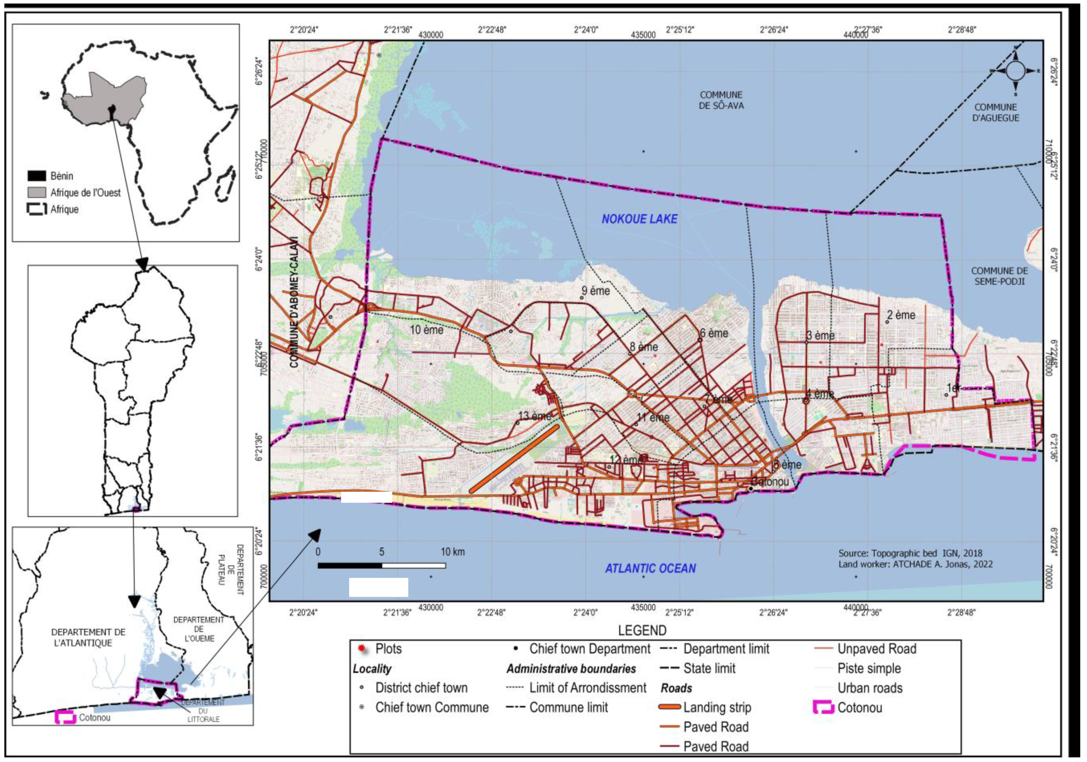
2.1. Area of Study
2.2. Data Collection
2.3. Statistical Analysis
3. Results
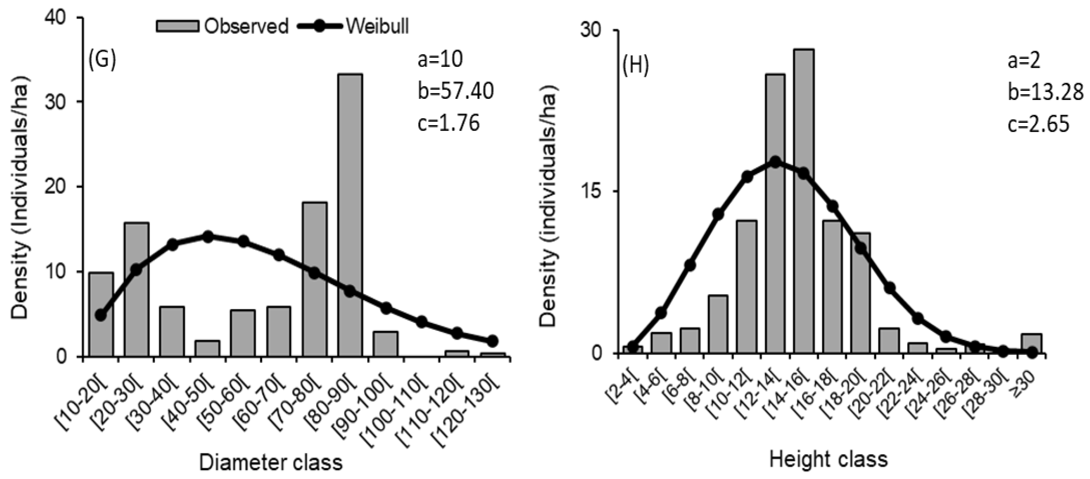
3.1. Diameter and Height Structures of Woody Plants
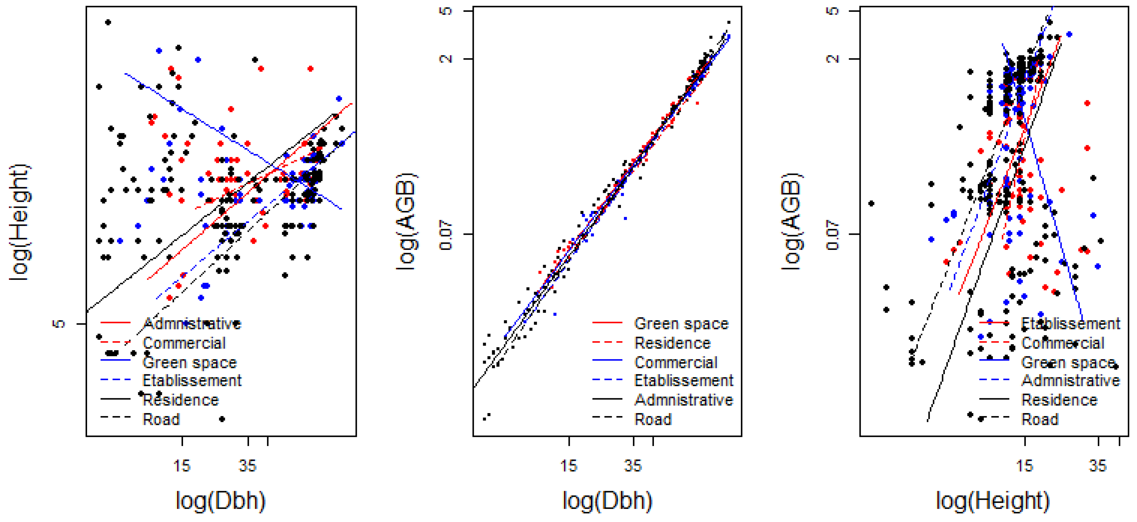
3.2. Similarity of Allometric Relationships and Aboveground Biomass Mobilization across Type of Land Use
3.3. Graphical Similarity of Allometric Relationships According to Type of Land Use
3.4. Structural Parameters and Aerial Carbon Density in the Different Land Use Units
3.5. Species with High Carbon Storage Potential
4. Discussion
4.1. Dendrometry Structure of Trees
4.2. Allometric Relationships and Aboveground Biomass Mobilization across Urban Types of Land Use
4.3. Structural Parameters and Tree Aboveground Carbon Storage Potential
5. Conclusions
Author Contributions
Funding
Institutional Review Board Statement
Informed Consent Statement
Data Availability Statement
Conflicts of Interest
References
- United Nations. Revision of World Urbanization Prospects. 2018. Available online: https://www.un.org/development/desa/en/news/population/2018-revision-of-world-urbanization-prospects.html (accessed on 4 April 2023).
- United Nations. World Urbanization Prospects. 2014. Demographic Research. 2023. Available online: https://esa.un.org/unpd/wup/publications/files/wup2014-report.pdf (accessed on 29 September 2023).
- Gnacadja, L. The cities of the Africa we want. Rise Africa, Inspiring Action for Sustainable Cities. In Discussion Series: Africa Is the 21st Century Global Gamechanger and the Role of Our Cities. 2022. Available online: https://riseafrica.iclei.org/wp-content/uploads/2022/04/The-AfricaWeWant_Luc-Gnacadja_pdf (accessed on 29 September 2023).
- Institut National de la Statistique et de l’Analyse Economique (INSAE). Rgph4: Que Retenir des Effectifs de Population en 2013; INSAE: Cotonou, Benin, 2015. [Google Scholar]
- Genete, M.M.; Bogale, W.B. Carbon storages and sequestration potentials in remnant forests of diferent patch sizes in northern Ethiopia: An implication for climate change mitigation. Agric. Food Secur. 2022, 11, 57. [Google Scholar] [CrossRef]
- Murtala, D.; Manaf, L.A.; Ramli, M.F.; Yacob, M.R.; Namadi, S. Exploring urban tree diversity and carbon stocks in Zaria Metropolis, North Western Nigeria. Appl. Geogr. 2021, 127, 102385. [Google Scholar]
- Wari, B.O.; Zakari, S.; Djaouga, M.; Imorou, I.T.; Yabi, I.; Tente, B.A.; Djego, J.G. Diversité et structure de la végétation ligneuse dans la ville de Malanville au Nord-Bénin. Int. J. Biol. Chem. Sci. 2021, 15, 129–143. [Google Scholar] [CrossRef]
- Lin, J.; Ma, Q.; Ju, Y.; Zhang, H.; Wang, Q.; Huang, B. Relationships between urbanization, tree morphology, and carbon density: An integration of remote sensing, allometric models, and field survey. Urban For. Urban Green. 2022, 76, 127725. [Google Scholar] [CrossRef]
- Schell, L.M.; Ulijaszek, S.J. Urbanism, Health and Human Biology in Industrialised Countries, Illustrate Ed.; Cambridge University Press: Cambridge, UK, 1999. [Google Scholar]
- Kroeger, T. Urban forests and pollution mitigation: Analyzing ecosystem services and disservices. Environ. Pollut. J. 2011, 159, 2078–2087. [Google Scholar]
- Moussa, S.; Boateng, K.; Shem, K.; Abasse, T.; Mahamane, S. Composition Floristique et Structure des Forêts Urbaines des Villes Sahéliennes: Cas de Niamey et Maradi, Niger. Sci. Vie Terre Agron. Rev. Ramres 2019, 7. [Google Scholar]
- Atchadé, A.J.; Kanda, M.; Folega, F.; Atela, J.; Dourma, M.; Wala, K.; Akpagana, K. Urban Ecosystem Services and Determinants of Stakeholders’ Perception for Sustainable Cities Planning in Cotonou (Benin). Sustainability 2023, 15, 9424. [Google Scholar] [CrossRef]
- Millennium Ecosystem Assessment. Ecosystems and Human Well Being: Desertification Synthesis, 2nd ed.; Island Press: New York, NY, USA, 2005. [Google Scholar]
- Wang, V.; Gao, J. Estimation of carbon stock in urban parks: Biophysical parameters, thresholds, reliability, and sampling load by plant type. Urban For. Urban Green. 2020, 55, 126852. [Google Scholar] [CrossRef]
- Gomez-Baggethun, E.; Barton, D.N. Classifying and valuing ecosystem services for urban planning. Ecol. Econ. 2013, 86, 235–245. [Google Scholar] [CrossRef]
- Nowak, D.J.; Greenfield, E.J.; Hoehn, R.E.; Lapoint, E. Carbon storage and sequestration by trees in urban and community areas of the United States. Environ. Pollut. 2013, 178, 229–236. [Google Scholar] [CrossRef]
- Shruti, L.; Lahoti, A.; Joshi, R.K.; Saito, O. Vegetation Structure, Species Composition, and Carbon Sink Potential of Urban Green Spaces in Nagpur City, India. Land 2020, 9, 107. [Google Scholar] [CrossRef]
- Useni, S.Y.; François, M.; Cabala, K.S.; Kalumba, M.A.; Mwana, Y.A.; Nkuku, K.C.; Jan, B.; Munyemba, K.F. Tree diversity and structure on green space of urban and peri-urban zones: The case of Lubumbashi City in the Democratic Republic of Congo. Urban For. Urban Green. 2019, 41, 67–74. [Google Scholar] [CrossRef]
- Fousséni, F.; Wouyo, A.; Madjouma, K.; Djibril, K.; Kissao, G.; Kperkouma, W. Flore des espaces verts urbains de la ville d’Atakpamé au Togo. Rev. Sci. Technol. Synthèse 2019, 25, 25–39. [Google Scholar]
- Nero, B.F.; Callo-concha, D. Structure, diversity, and carbon stocks of the tree community of Kumasi, Ghana. Forests 2018, 9, 519. [Google Scholar] [CrossRef]
- McPherson, E.G. Atmospheric carbon dioxide reduction by Sacramento’s urban forest. J. Arboric. 1998, 24, 215–223. [Google Scholar] [CrossRef]
- Dorney, J.R.; Guntenspergen, G.R.; Keough, J.R.; Stearns, F. Composition and structure of an urban woody plant community. J. Urban Ecol. 1984, 8, 69–90. [Google Scholar] [CrossRef]
- Sehoun, L.C.; Lougbegnon, T.O.; Codjia, J.C.T. Connaissances Et Perceptions Des Services Écosystémiques Des Espaces Verts Des Villes De Cotonou, Abomey-Calavi Et Allada Du Sud Bénin: Implications Pour La Gestion Durable Des Forêts Urbaines Et Péri-Urbaines. Eur. Sci. J. 2020, 16, 284. [Google Scholar] [CrossRef]
- Teka, O.; Togbe, C.E.; Djikpo, R.; Chabi, R.; Djossa, B. Effects of Urban Forestry on the Local Climate in Cotonou, Benin Republic. Agric. For. Fish. 2017, 6, 123–129. [Google Scholar] [CrossRef]
- Osseni, A.A. Diversite floristique et facteurs d’influence de la survie des jeunes arbres d’accompagnement de rue dans la ville de Cotonou. J. Rech. Sci. Univ. Lomé 2022, 24, 77–91. [Google Scholar]
- Atchadé, A.J.; Kanda, M.; Folega, F.; Yédomonhan, H.; Dourma, M.; Wala, K.; Akpagana, K. Trees Diversity and Species with High Ecological Importance for a Resilient Urban Area: Evidence from Cotonou City (West Africa). Climate 2023, 11, 182. [Google Scholar] [CrossRef]
- Amontcha, A.A.M. Typologie, Utilités et Contraintes à L’aménagement des Espaces Verts Dans les Villes du Grand Nokoué (sud-Bénin). Ph.D. Thesis, Université d’Abomey-Calavi, Abomey-Calavi, Benin, 2018. [Google Scholar]
- Vroh, B.; Tiebre, M.S.; N’guessan, K.E. Diversité végétale urbaine et estimation du stock de carbone: Cas de la commune du Plateau Abidjan, Côte d’Ivoire. Afr. Sci. Rev. Int. Des Sci. Technol. 2014, 10, 109751. [Google Scholar]
- Nero, B.F.; Campion, B.B.; Agbo, N.; Callo-Concha, D.; Denich, M. Tree and trait diversity, species coexistence, and diversity functional relations of green spaces in Kumasi, Ghana. Procedia Eng. 2017, 198, 99–115. [Google Scholar] [CrossRef]
- Muluneh, M.G.; Worku, B.B. Contributions of urban green spaces for climate change mitigation and biodiversity conservation in Dessie city, Northeastern Ethiopia. Urban Clim. 2022, 46, 101294. [Google Scholar] [CrossRef]
- Behera, S.K.; Mishra, S.; Sahu, N.; Manika, N.; Singh, S.N.; Anto, S.; Kumar, R.; Husain, R.; Verma, A.K.; Pandey, N. Assessment of carbon sequestration potential of tropical tree species for urban forestry in India. Ecol. Eng. 2022, 181, 106692. [Google Scholar] [CrossRef]
- Beatley, T. Green Urbanism: Learning from European Cities, revised ed.; Island Press: London, UK, 2012. [Google Scholar]
- Bekele, A. Useful Trees and Shrubs for Ethiopia: Identification, Propagation and Management in 17 Agro-Ecological Zones; RELMA in ICRAF Project, World Agroforestry Centre (ICRAF): Nairobi, Kenya, 2007. [Google Scholar]
- Davies, Z.G.; Edmondson, J.L.; Heinemeyer, A.; Leake, J.R.; Gaston, K.J. Mapping an urban ecosystem service: Quantifying above-ground carbon storage at a city-wide scale. J. Appl. Ecol. 2011, 48, 1125–1134. [Google Scholar] [CrossRef]
- Tang, Y.; Chen, A.; Zhao, S. Carbon storage and sequestration of urban street trees in Beijing, China. Front. Ecol. Evol. 2016, 4, 00053. [Google Scholar] [CrossRef]
- Agbani, B.S.; Vissoh, S.A.; Kadjegbin, T.R.G.; Bio Bigou, L.B. Gestion Des Espaces Verts Dans La Ville De Cotonou Au Sud Du Benin: Etat Des Lieux Et Perspectives. Int. J. Progress. Sci. Technol. 2021, 25, 639–649. [Google Scholar] [CrossRef]
- Institut National de la Statistique et de l’Analyse Economique (INSAE). Recensement Général de la Population et de L’habitat 4 (RGPH4); Rise Africa: Cape Town, South Africa, 2015. [Google Scholar]
- Boko, M. Climats et communautés rurales du Bénin: Rythmes climatiques et rythmes de développement. Ph.D. Thesis, University of Bourgogne, Dijon, France, 1988. Available online: https://www.persee.fr/doc/geo_0003-4010_1989_num_98_545_20895_t1_0117_0000_3 (accessed on 29 September 2023).
- FAO. Guidelines on Urban and Peri-Urban Forestry; Forestry Paper; FAO: Rome, Italy, 2016. [Google Scholar]
- Thiombiano, A.; Glele Kakaï, R.; Bayen, P.; Boussim, J.I.; Mahamane, A. Méthodes et dispositifs d’inventaires forestiers en afrique de l’ouest: État des lieux et propositions pour une harmonisation. Ann. Sci. Agron. 2016, 20, 15–31. [Google Scholar]
- Bailey, R.L.; Dell, T.R. Quantifying diameter distributions with the Weibull function. For. Sci. 1973, 19, 97–104. [Google Scholar]
- Husch, B.; Beers, T.; Kershaw, J., Jr. Forest Mensuration, 4th ed.; John Wiley & Sons: Hoboken, NJ, USA, 2003. [Google Scholar]
- Lucas, G.K.R.; Anne, M.L. Approche méthodologique de construction et d’interprétation des structures en diamètre des arbres. Ann. Sci. Agron. 2016, 20, 99–112. [Google Scholar]
- Warton, D.I.; Duursma, R.A.; Falster, D.S.; Taskinen, S. smatr 3—An R package for estimation and inference about allometric lines. Methods Ecol. Evol. 2012, 3, 257–259. [Google Scholar] [CrossRef]
- Henry, M.; Bombelli, A.; Trotta, C.; Alessandrini, A.; Birigazzi, L.; Sola, G.; Vieilledent, G.; Santenoise, P.; Longuetaud, F.; Valentini, R.; et al. GlobAllomeTree: International platform for tree allometric equations to support volume, biomass and carbon assessment. iForest 2013, 6, 326–330. [Google Scholar] [CrossRef]
- Konijnendijk, C.C.; Sadio, S.; Randrup, T.B.; Schipperijn, J. Urban and peri-urban forestry in a development context—Strategy and implementation. J. Arboric. 2004, 30, 269. [Google Scholar]
- Chave, J.; Mechain, M.R.; Burquez, A.; Chidumayo, E.; Colgan, M.S.; Delitti, W.B.; Duque, A.; Eid, T.; Fearnside, P.M.; Goodman, R.C.; et al. Improved allometric models to estimate the aboveground biomass of tropical trees. Glob. Chang. Biol. 2014, 20, 3177–3190. [Google Scholar] [CrossRef]
- Zanne, A.E.; Lopez-Gonzalez, G.; Coomes, D.A.; Ilic, J.; Jansen, S.; Lewis, S.L.; Miller, R.B.; Swenson, N.G.; Wiemann, M.C.; Chave, J. Global Wood Density Database. 2009. Available online: http://hdl.handle.net/10255/dryad.235 (accessed on 10 January 2023).
- IPCC. ANNEX 2: Summary of Equations: IPCC Guidelines for National Greenhouse Gas Inventories. 2006. pp. 1–34. Available online: www.ipcc-nggip.iges.or.jp/public/2006gl/vol4.html (accessed on 15 August 2023).
- de Mendiburu, F. Agricolae: Statistical Procedures for Agricultural Research; R package version 1.3-5. 2021. Available online: https://cran.r-project.org/web/packages/agricolae/agricolae.pdf (accessed on 29 September 2023).
- Moussa, S.; Boateng, K.; Abasse, T.; Shem, K.; Mahamane, S. West African Sahelian cities as source of carbon stocks: Evidence from Niger. Sustain. Cities Soc. 2019, 50, 101653. [Google Scholar] [CrossRef]
- Osseni, A.; Toko, M.; Tohozin, B.; Sinsin, B. SIG et gestion des espaces verts dans la ville de PortoNovo au Bénin. Tropicultura 2015, 33, 146–156. [Google Scholar]


| Type of Land Use | Statistics | Height vs. Dbh | AGB vs. Dbh | AGB vs. Height | |||
|---|---|---|---|---|---|---|---|
| Elevation | Slope | Elevation | Slope | Elevation | Slope | ||
| Administrative | Estimate | 0.36 | 0.48 | −3.64 | 2.00 | −5.15 | 4.16 |
| Liminf | 0.17 | 0.38 | −3.71 | 1.95 | −6.30 | 3.30 | |
| Limsup | 0.56 | 0.61 | −3.56 | 2.04 | −4.00 | 5.26 | |
| R2 = 0.99 | p < 0.001 | R2 = 0.99 | p < 0.001 | R2 = 0.01 | p = 0.339 | ||
| Commercial area | Estimate | 0.72 | 0.27 | −3.65 | 1.96 | −9.00 | 7.39 |
| Liminf | 0.57 | 0.18 | −3.71 | 1.92 | −12.20 | 5.09 | |
| Limsup | 0.88 | 0.39 | −3.58 | 2.00 | −5.81 | 10.73 | |
| R2 = 0.99 | p < 0.001 | R2 = 0.99 | p < 0.001 | R2 = 0.03 | p = 0.362 | ||
| Green spaces | Estimate | 1.77 | −0.35 | −3.61 | 1.96 | 6.48 | −5.69 |
| Liminf | 1.57 | −0.47 | −3,69 | 1.92 | 4.33 | −7.81 | |
| Limsup | 1.97 | −0.25 | −3.52 | 2.01 | 8.62 | −4.14 | |
| R2 = 0.99 | p < 0.001 | R2 = 0.99 | p < 0.001 | R2 = 0.00 | p = 0.583 | ||
| Establishments | Estimate | 0.30 | 0.46 | −3.83 | 2.08 | −5.19 | 4.51 |
| Liminf | 0.19 | 0.41 | −3.90 | 2.05 | −5.87 | 3.94 | |
| Limsup | 0.41 | 0.53 | −3.77 | 2.12 | −4.50 | 5.15 | |
| R2 = 0.99 | p < 0.001 | R2 = 0.99 | p < 0.001 | R2 = 0.25 | p = 0.060 | ||
| Residential area | Estimate | 0.45 | 0.44 | −3.74 | 2.04 | −5.83 | 4.62 |
| Liminf | 0.34 | 0.38 | −3.80 | 2.01 | −6.69 | 3.93 | |
| Limsup | 0.57 | 0.52 | −3.68 | 2.08 | −4.98 | 5.44 | |
| R2 = 0.99 | p < 0.001 | R2 = 0.99 | p < 0.001 | R2 = 0.02 | p = 0.095 | ||
| Roads | Estimate | 0.19 | 0.51 | −3.89 | 2.14 | −3.89 | 4.17 |
| Liminf | 0.06 | 0.44 | −3.94 | 2.11 | −3.94 | 3.62 | |
| Limsup | 0.32 | 0.59 | −3.83 | 2.17 | −3.83 | 4.80 | |
| R2 = 0.99 | p < 0.001 | R2 = 0.99 | p < 0.001 | R2 = 0.46 | p = 0.000 | ||
| Type of Land Use | G (m2 ha−1) | N (feet ha−1) | Dbh (cm) | H (m) | AGC × 103 (kg ha−1) | |||||
|---|---|---|---|---|---|---|---|---|---|---|
| Mean | ET | Mean | ET | Mean | ET | Mean | ET | Mean | ET | |
| Administrative area | 3.00 b | 4.91 | 10.0 d | 8.73 | 54.91 b | 28.14 | 15.20 a | 5.09 | 0.88 bc | 0.72 |
| Commercial area | 2.39 b | 3.31 | 15.00 b | 13.48 | 39.25 c | 22.54 | 13.6 ab | 2.03 | 0.39 d | 0.47 |
| Green spaces | 7.37 a | 8.35 | 15.60 b | 14.54 | 70.78 a | 27.05 | 14.96 ab | 4.89 | 1.21 a | 0.63 |
| Establishments | 5.65 ab | 4.75 | 13.87 c | 7.68 | 67.30 a | 25.06 | 13.68 ab | 3.16 | 1.10 ab | 0.62 |
| Residential area | 2.69 b | 3.74 | 9.60 d | 6.76 | 44.17 c | 31.94 | 13.84 ab | 5.83 | 0.65 c | 0.73 |
| Roads | 7.56 a | 6.23 | 18.73 a | 11.34 | 65.19 a | 26.61 | 12.91 b | 3.31 | 1.19 a | 0.76 |
| Globale | 4.5 | 5.24 | 12.72 | 9.42 | 57.94 | 29.71 | 13.86 | 4.42 | 0.94 | 0.73 |
| Fvalue/Deviance | 5.02 | 170.47 | 17.33 | 2.91 | 14.96 | |||||
| Probability | <0.001 | <0.001 | <0.001 | 0.01 | <0.001 | |||||
| Species | Family | Mean AGC × 103 (kg ha−1) | SE |
|---|---|---|---|
| Khaya senegalensis 1 | Meliaceae | 1.49 | 0.06 |
| Mangifera indica 2 | Anacardiaceae | 1.44 | 0.04 |
| Terminalia mantaly 2 | Combretaceae | 1.35 | 0.06 |
| Leucaena leucocephala 2 | Fabaceae | 1.23 | 0.23 |
| Terminalia cattapa2 | Combretaceae | 1.18 | 0.05 |
| Azadirachta indica 2 | Meliaceae | 0.56 | 0.20 |
| Tectona grandis 2 | Verbenaceae | 0.55 | 0.00 |
| Casuarina equisetifolia 2 | Casuarinaceae | 0.51 | 0.36 |
| Polyalthia longifolia 2 | Annonacées | 0.30 | 0.05 |
| Acacia auriculiformis 2 | Fabaceae | 0.26 | 0.03 |
Disclaimer/Publisher’s Note: The statements, opinions and data contained in all publications are solely those of the individual author(s) and contributor(s) and not of MDPI and/or the editor(s). MDPI and/or the editor(s) disclaim responsibility for any injury to people or property resulting from any ideas, methods, instructions or products referred to in the content. |
© 2023 by the authors. Licensee MDPI, Basel, Switzerland. This article is an open access article distributed under the terms and conditions of the Creative Commons Attribution (CC BY) license (https://creativecommons.org/licenses/by/4.0/).
Share and Cite
Atchadé, A.J.; Kanda, M.; Folega, F.; Diouf, A.A.; Agbahoungba, S.; Dourma, M.; Wala, K.; Akpagana, K. Urban Flora Structure and Carbon Storage Potential of Woody Trees in Different Land Use Units of Cotonou (West Africa). Urban Sci. 2023, 7, 106. https://doi.org/10.3390/urbansci7040106
Atchadé AJ, Kanda M, Folega F, Diouf AA, Agbahoungba S, Dourma M, Wala K, Akpagana K. Urban Flora Structure and Carbon Storage Potential of Woody Trees in Different Land Use Units of Cotonou (West Africa). Urban Science. 2023; 7(4):106. https://doi.org/10.3390/urbansci7040106
Chicago/Turabian StyleAtchadé, Assouhan Jonas, Madjouma Kanda, Fousseni Folega, Abdoul Aziz Diouf, Symphorien Agbahoungba, Marra Dourma, Kperkouma Wala, and Koffi Akpagana. 2023. "Urban Flora Structure and Carbon Storage Potential of Woody Trees in Different Land Use Units of Cotonou (West Africa)" Urban Science 7, no. 4: 106. https://doi.org/10.3390/urbansci7040106
APA StyleAtchadé, A. J., Kanda, M., Folega, F., Diouf, A. A., Agbahoungba, S., Dourma, M., Wala, K., & Akpagana, K. (2023). Urban Flora Structure and Carbon Storage Potential of Woody Trees in Different Land Use Units of Cotonou (West Africa). Urban Science, 7(4), 106. https://doi.org/10.3390/urbansci7040106