Spatiotemporal Analysis of Emergency Calls during the COVID-19 Pandemic: Case of the City of Vaughan
Abstract
1. Introduction and Background
2. Datasets and Methods
2.1. Study Area
2.2. Data Collection and Preparation
2.3. Methods
3. Analyses and Findings
3.1. Density Analyses/Findings
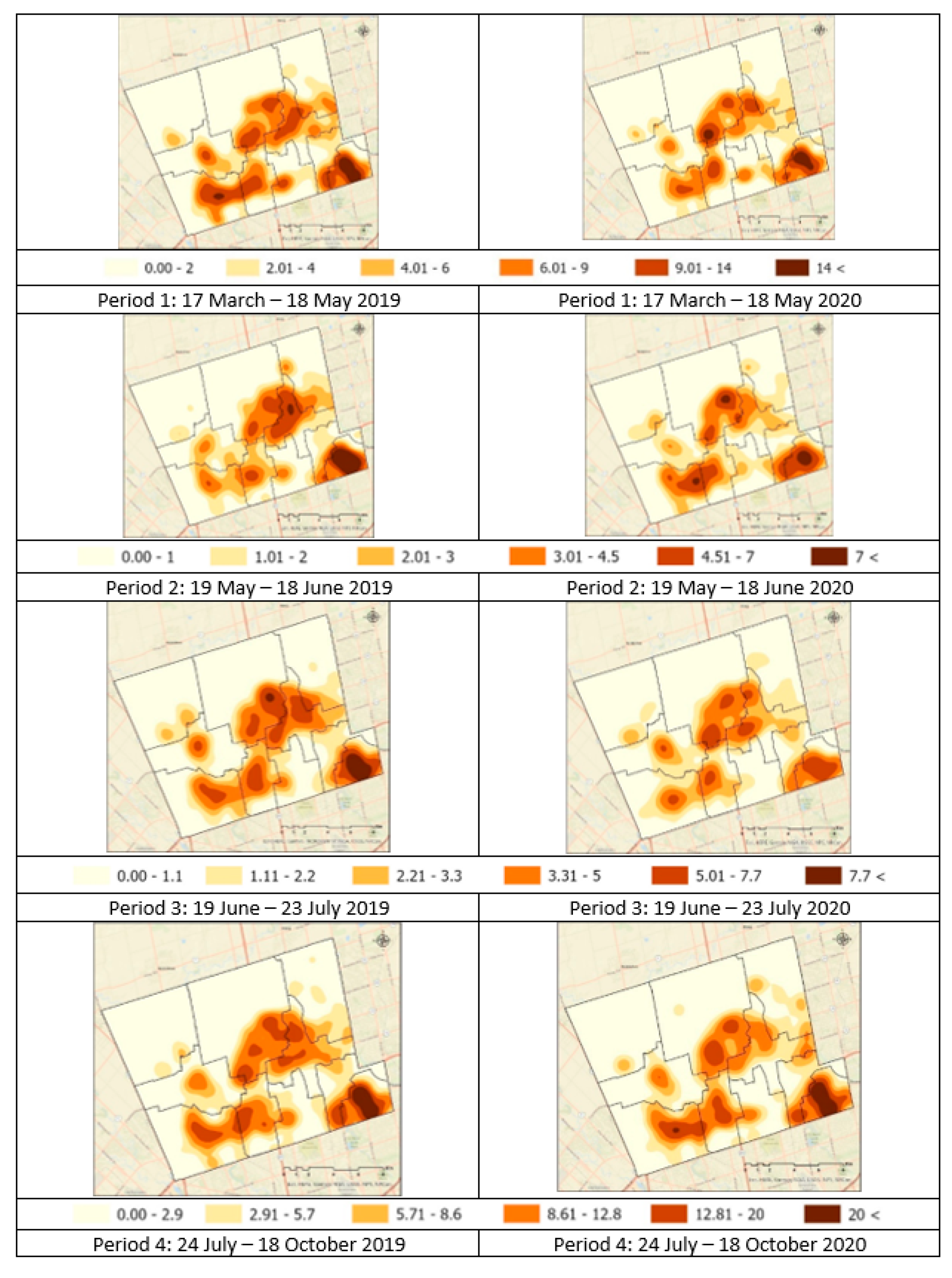
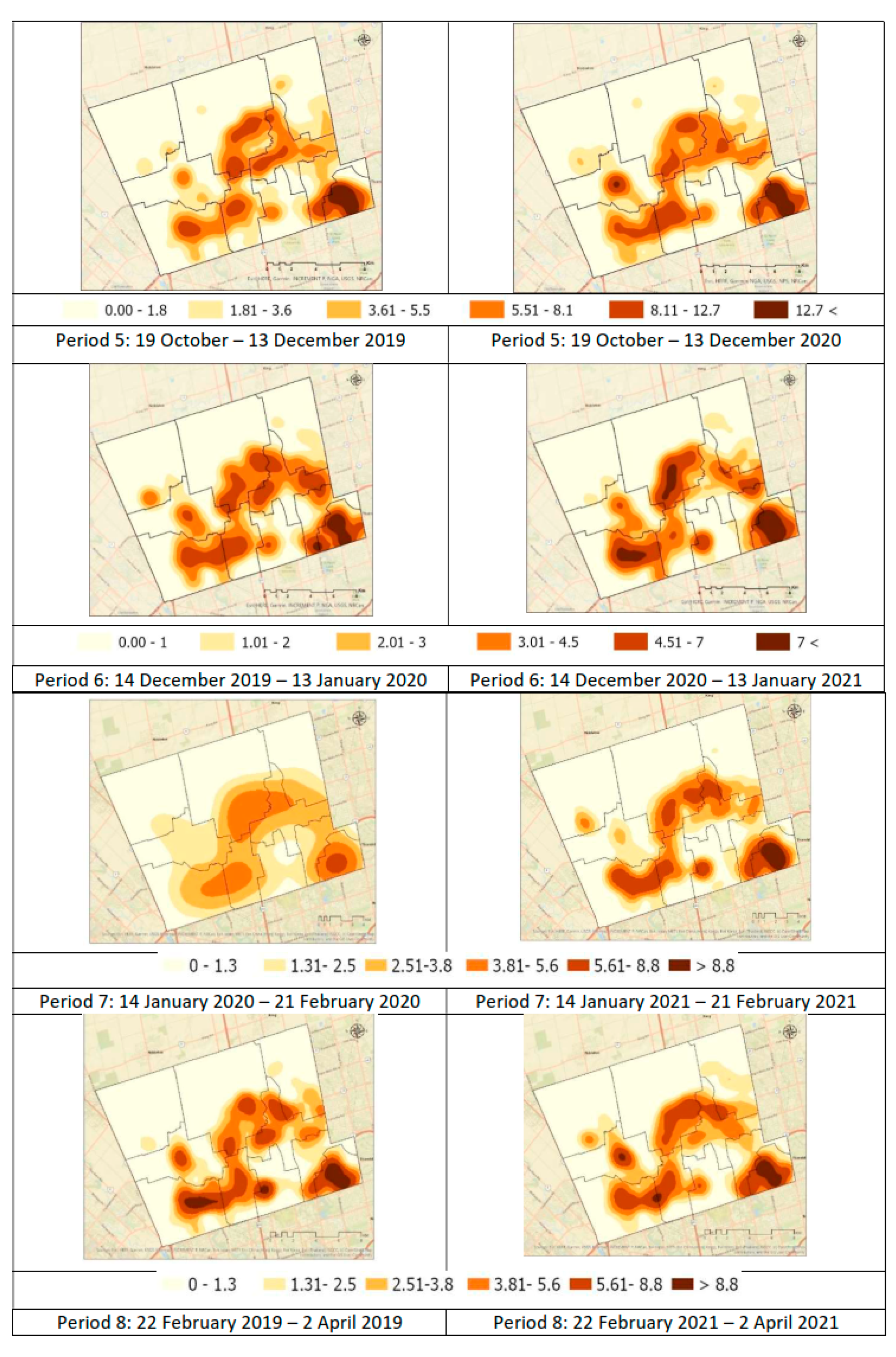
3.1.1. All Emergency Calls
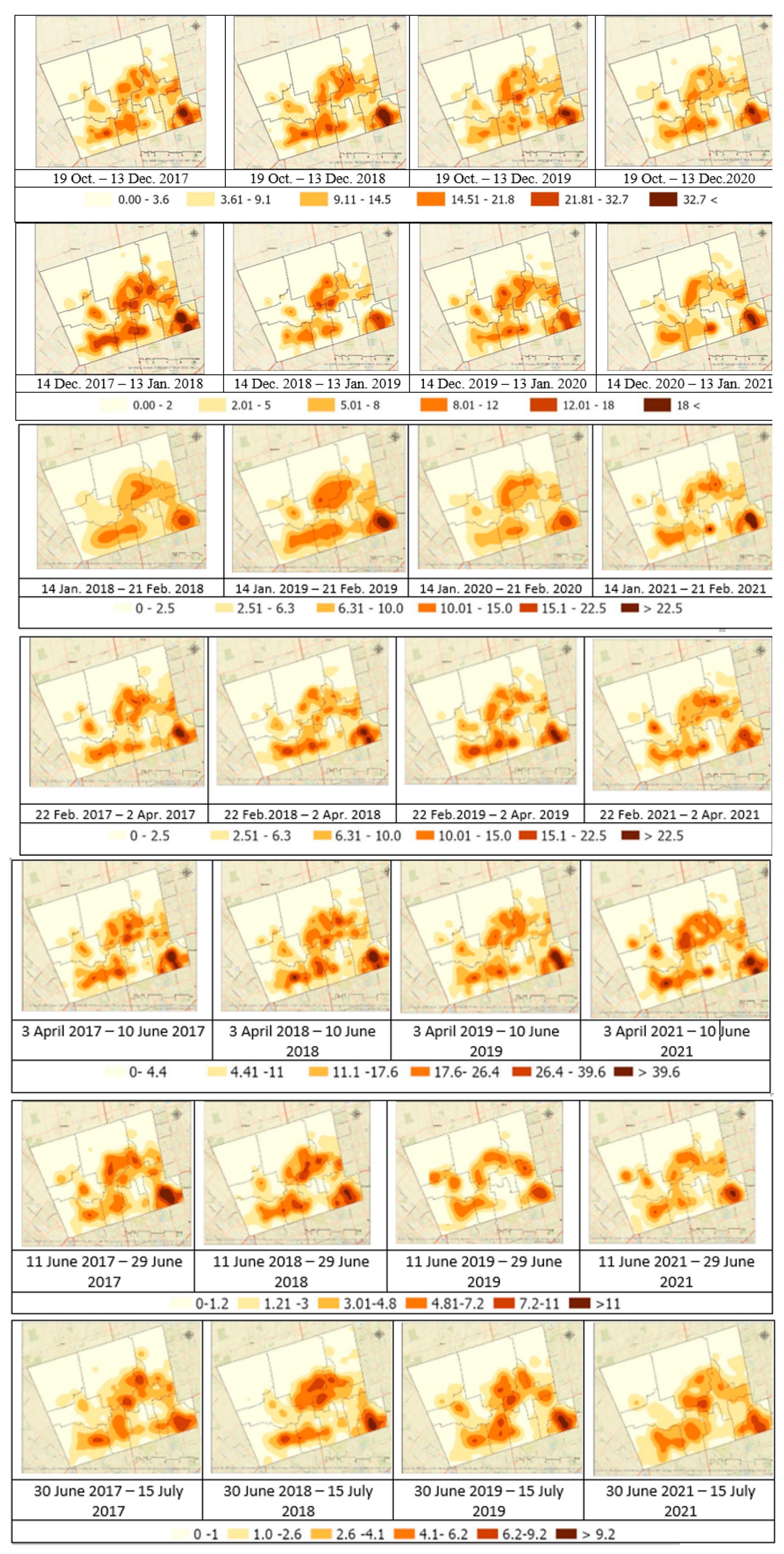
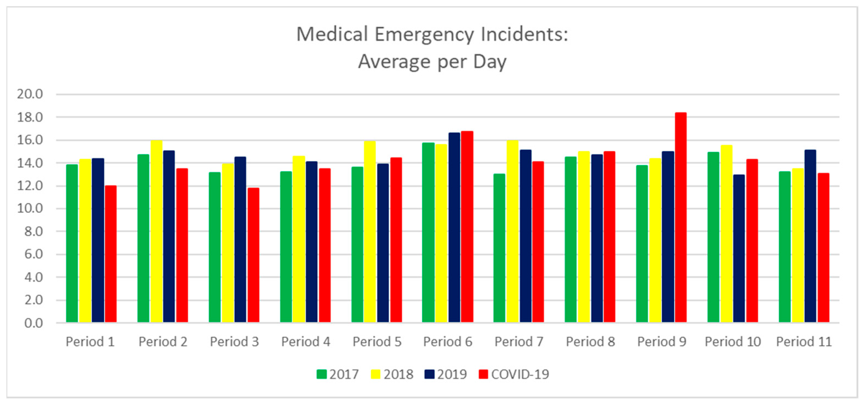
3.1.2. Medical Emergencies
3.1.3. Vehicle Collisions/Extrications
3.1.4. False Fire Calls
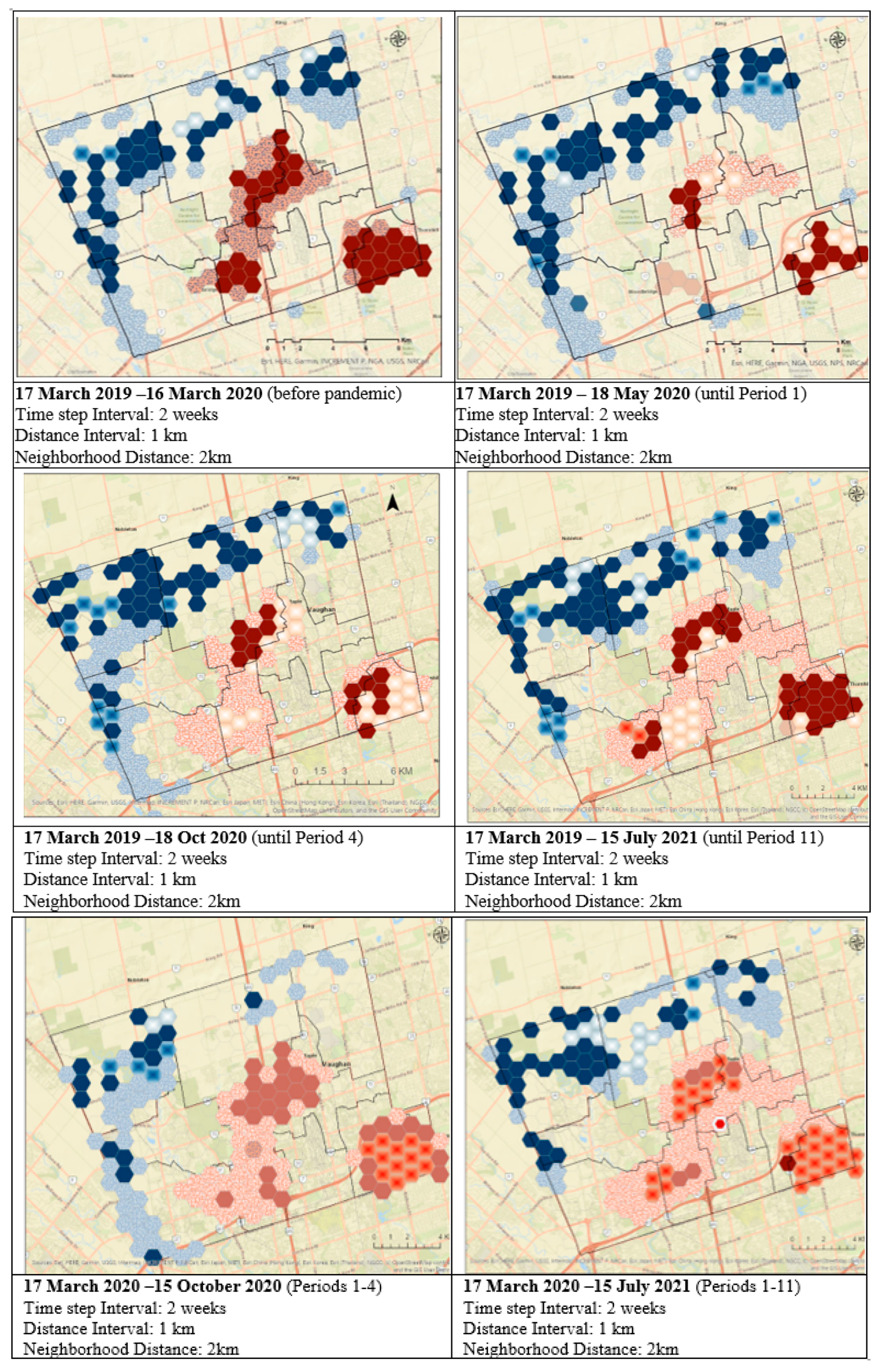
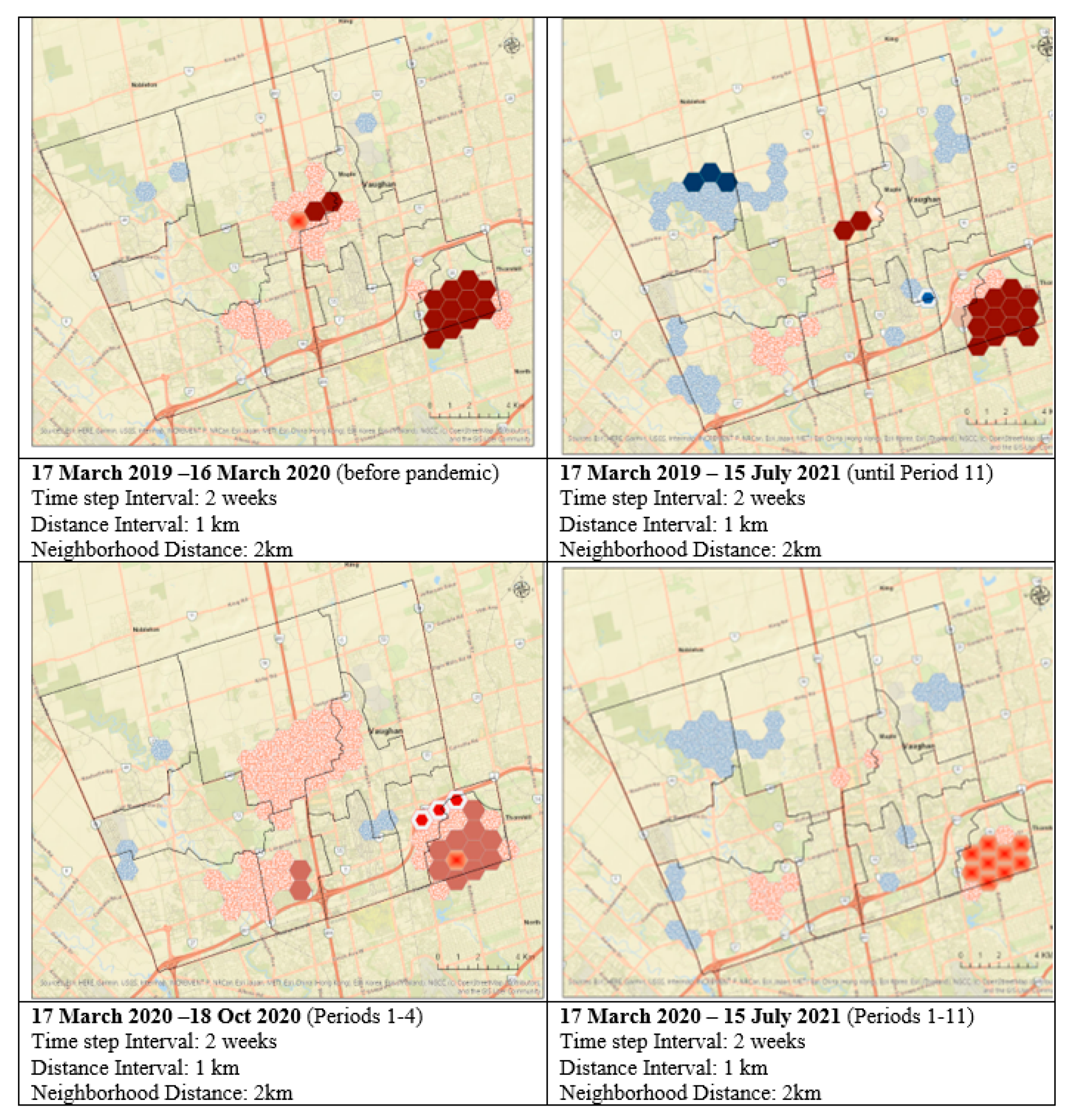
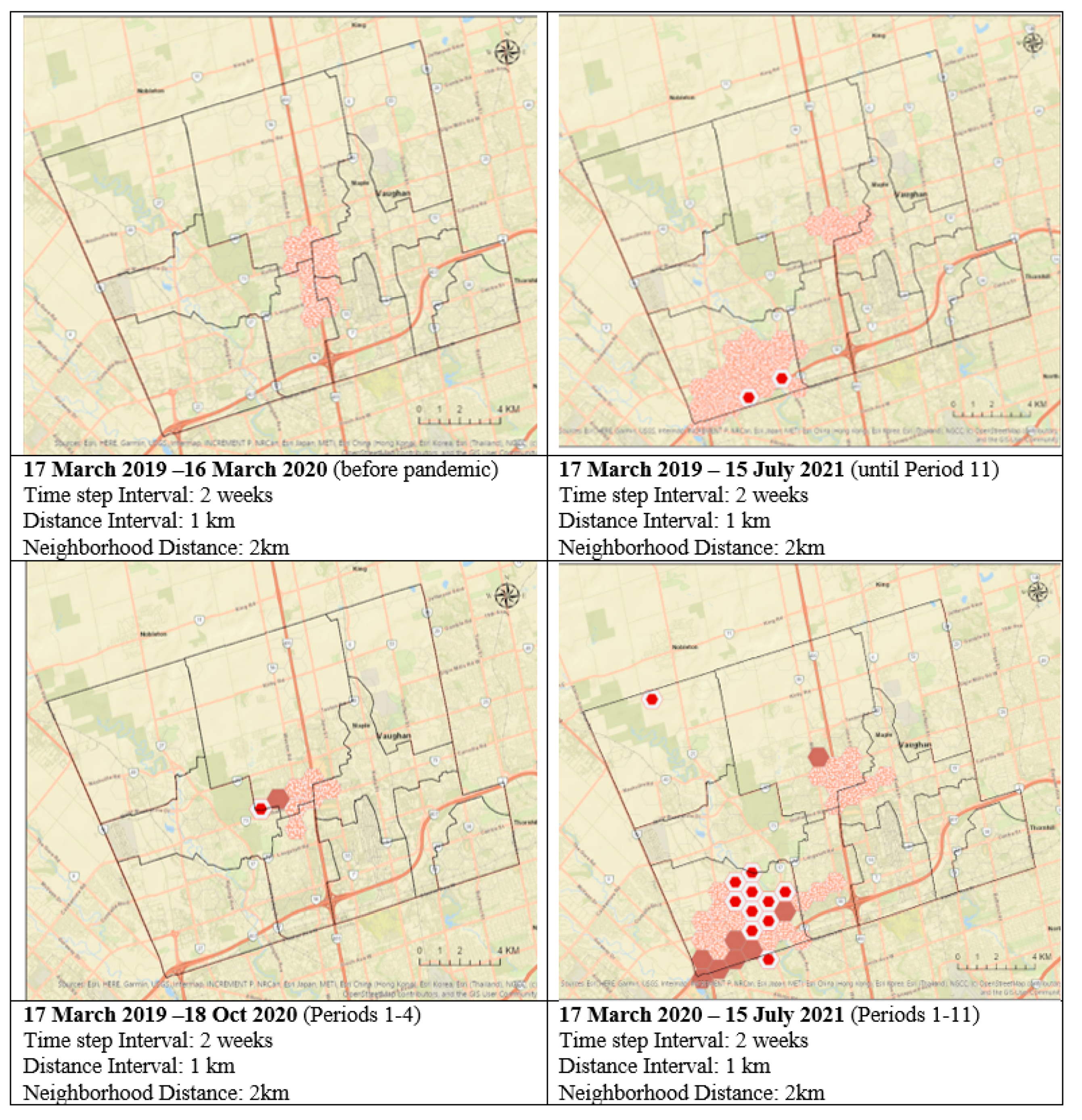
3.2. Emerging Hotspot Analysis
3.2.1. All Emergencies
3.2.2. Medical Emergencies
3.2.3. Vehicle Collisions/Extrications
4. Discussion
5. Conclusions
Author Contributions
Funding
Data Availability Statement
Conflicts of Interest
References
- Gudes, O.; Varhol, R.; Sun, Q.C.; Meuleners, L. Investigating articulated heavy-vehicle crashes in Western Australia using a spatial approach. Accid. Anal. Prev. 2017, 106, 243–253. [Google Scholar] [CrossRef] [PubMed]
- Rabiei-Dastjerdi, H.; McArdle, G. Identifying patterns of neighbourhood change based on spatiotemporal analysis of airbnb data in Dublin. In Proceedings of the 2020 4th International Conference on Smart Grid and Smart Cities (ICSGSC), Osaka, Japan, 18–21 August 2020. [Google Scholar] [CrossRef]
- Reddy, C.S.; Unnikrishnan, A.; Bird, N.G.; Faseela, V.S.; Asra, M.; Manikandan, T.M.; Rao, P.V.N. Characterizing vegetation fire dynamics in Myanmar and South Asian countries. J. Indian Soc. Remote Sens. 2020, 48, 1829–1843. [Google Scholar] [CrossRef]
- Hart, T.C. Investigating crime pattern stability at micro-temporal intervals: Implications for crime analysis and hotspot policing strategies. Crim. Justice Rev. 2021, 46, 173–189. [Google Scholar] [CrossRef]
- Adepeju, M.; Rosser, G.; Cheng, T. Novel evaluation metrics for sparse spatio-temporal point process hotspot predictions—A crime case study. Int. J. Geogr. Inf. Sci. 2016, 30, 2133–2154. [Google Scholar] [CrossRef]
- Mohler, G. Marked point process hotspot maps for homicide and gun crime prediction in Chicago. Int. J. Forecast. 2014, 30, 491–497. [Google Scholar] [CrossRef]
- Chainey, S.; Tompson, L.; Uhlig, S. The utility of hotspot mapping for predicting spatial patterns of crime. Secur. J. 2008, 21, 4–28. [Google Scholar] [CrossRef]
- Mollalo, A.; Vahedi, B.; Rivera, K.M. GIS-based spatial modeling of COVID-19 incidence rate in the continental United States. Sci. Total Environ. 2020, 728, 138884. [Google Scholar] [CrossRef] [PubMed]
- Mylona, E.K.; Shehadeh, F.; Kalligeros, M.; Benitez, G.; Chan, P.A.; Mylonakis, E. Real-Time spatiotemporal analysis of microepidemics of influenza and COVID-19 based on hospital network data: Colocalization of neighborhood-level hotspots. Am. J. Public Health 2020, 110, 1817–1824. [Google Scholar] [CrossRef] [PubMed]
- Andersen, L.M.; Harden, S.R.; Sugg, M.M.; Runkle, J.D.; Lundquist, T.E. Analyzing the spatial determinants of local Covid-19 transmission in the United States. Sci. Total Environ. 2021, 754, 142396. [Google Scholar] [CrossRef] [PubMed]
- Purwanto, P.; Utaya, S.; Handoyo, B.; Bachri, S.; Astuti, I.S.; Utomo, K.S.B.; Aldianto, Y.E. Spatiotemporal analysis of COVID-19 spread with emerging hotspot analysis and space–time cube models in East Java, Indonesia. ISPRS Int. J. Geo-Inf. 2021, 10, 133. [Google Scholar] [CrossRef]
- Achu, A.L.; Reghunath, R.; Thomas, J. Mapping of groundwater recharge potential zones and identification of suitable site-specific recharge mechanisms in a tropical river basin. Earth Syst. Environ. 2020, 4, 131–145. [Google Scholar] [CrossRef]
- Bulai, A.T.; Rosu, L.; Banica, A. Patterns of urban fire occurence in Iasi city (Romania). Present Environ. Sustain. Dev. 2019, 13, 87–102. [Google Scholar] [CrossRef]
- Špatenková, O.; Virrantaus, K. Discovering spatio-temporal relationships in the distribution of building fires. Fire Saf. J. 2013, 62, 49–63. [Google Scholar] [CrossRef]
- Yao, J.; Zhang, X. Spatial-Temporal Dynamics of Urban Fire Incidents: A Case Study of Nanjing, China. ISPRS Int. Arch. Photogramm. Remote Sens. Spat. Inf. Sci. 2016, XLI-B2, 63–69. [Google Scholar] [CrossRef]
- Yao, H.; Liu, Y.; Wei, Y.; Tang, X.; Li, Z. Learning from Multiple Cities: A Meta-Learning Approach for Spatial-Temporal Prediction. In Proceedings of the World Wide Web Conference, San Francisco, CA, USA, 13–17 May 2019; ACM Press: New York, NY, USA, 2019. [Google Scholar] [CrossRef]
- Bringula, R.; Balahadia, F. A spatiotemporal analysis of fire incidents in Manila from 2011-2016: Implications for fire prevention. Disaster Prev. Manag. Int. J. 2019, 28, 201–215. [Google Scholar] [CrossRef]
- Sabet, M.S.; Asgary, A.; Solis, A.O. Emergency calls during the 2013 southern Ontario ice storm: Case study of Vaughan. Int. J. Emerg. Serv. 2019, 8, 292–314. [Google Scholar] [CrossRef]
- Solis, A.O.; Wimaladasa, J.; Asgary, A.; Sabet, M.S.; Ing, M. Shifting patterns of emergency incidents during the COVID-19 pandemic in the City of Vaughan, Canada. Int. J. Emerg. Serv. 2022, 11, 1–37. [Google Scholar] [CrossRef]
- Office of the Premier. Ontario Enacts Declaration of Emergency to Protect the Public. Government of Ontario; 17 March 2020. Available online: https://news.ontario.ca/en/release/56356/ontario-enacts-declaration-of-emergency-to-protect-the-public (accessed on 16 May 2023).
- Province of Ontario. Reopening of Ontario in Stages, Archived. Available online: https://news.ontario.ca/en/release/1001600/ontario-moving-to-next-phase-of-reopening-on-february-17 (accessed on 16 May 2023).
- Office of the Premier. A Framework for Reopening Our Province: Stage 3. Government of Ontario; 13 July 2020. Available online: https://www.hawkesbury.ca/images/2020/mof-framework-reopening-province-stage-3-en-2020-07-13.pdf (accessed on 16 May 2023).
- Office of the Premier. Ontario Moving Additional Region to Modified Stage 2. Government of Ontario, News Release; 16 October 2020. Available online: https://news.ontario.ca/en/release/58842/ontario-moving-additional-region-to-modified-stage-2 (accessed on 16 May 2023).
- Office of the Premier. COVID-19 Response Framework: Keeping Ontario Safe and Open—Lockdown Measures. Government of Ontario; 22 November 2020. Available online: https://files.ontario.ca/moh-covid-19-response-framework-keeping-ontario-safe-and-open-en-2020-11-24.pdf (accessed on 16 May 2023).
- York Region. York Region Placed in Lockdown for Minimum 28 Days. Media Release. 11 December 2020. Available online: https://www.york.ca/newsroom/chairman-statement/york-region-placed-lockdown-minimum-28-days (accessed on 16 May 2023).
- Province of Ontario. O. Reg. 11/21: Stay-at-Home Order. Available online: https://www.ontario.ca/laws/regulation/210011 (accessed on 16 May 2023).
- York Region. ‘Hopefully It Doesn’t Backfire’: York Region Reacts to Moving into COVID-19 Red Zone Feb. 22. Available online: https://www.yorkregion.com/news/hopefully-it-doesnt-backfire-york-region-reacts-to-moving-into-covid-19-red-zone-feb/article_176977e4-543b-5f3d-98e1-8ba2ce244e56.html (accessed on 16 May 2023).
- Office of the Premier. Ontario Implements Provincewide Emergency Brake. Government of Ontario. Available online: https://news.ontario.ca/en/release/60986/ontario-implements-provincewide-emergency-brake (accessed on 16 May 2023).
- Office of the Premier. Ontario Enacts Provincial Emergency and Stay-at-Home Order. Government of Ontario. Available online: https://news.ontario.ca/en/release/61029/ontario-enacts-provincial-emergency-and-stay-at-home-order (accessed on 16 May 2023).
- Office of the Premier. Ontario to Move to Step One of Roadmap to Reopen on June 11. Government of Ontario. Available online: https://news.ontario.ca/en/release/1000279/ontario-to-move-to-step-one-of-roadmap-to-reopen-on-june-11 (accessed on 16 May 2023).
- Office of the Premier. Ontario Moving to Step Two of Roadmap to Reopen on June 30. Government of Ontario. Available online: https://news.ontario.ca/en/release/1000399/ontario-moving-to-step-two-of-roadmap-to-reopen-on-june-30 (accessed on 16 May 2023).
- Silverman, B.W. Density Estimation for Statistics and Data Analysis; Chapman and Hall: London, UK, 1986. [Google Scholar]
- ESRI. How Emerging Hot Spot Analysis Works. ESRI. 2023. Available online: https://pro.arcgis.com/en/pro-app/latest/tool-reference/space-time-pattern-mining/learnmoreemerging.htm (accessed on 16 May 2023).
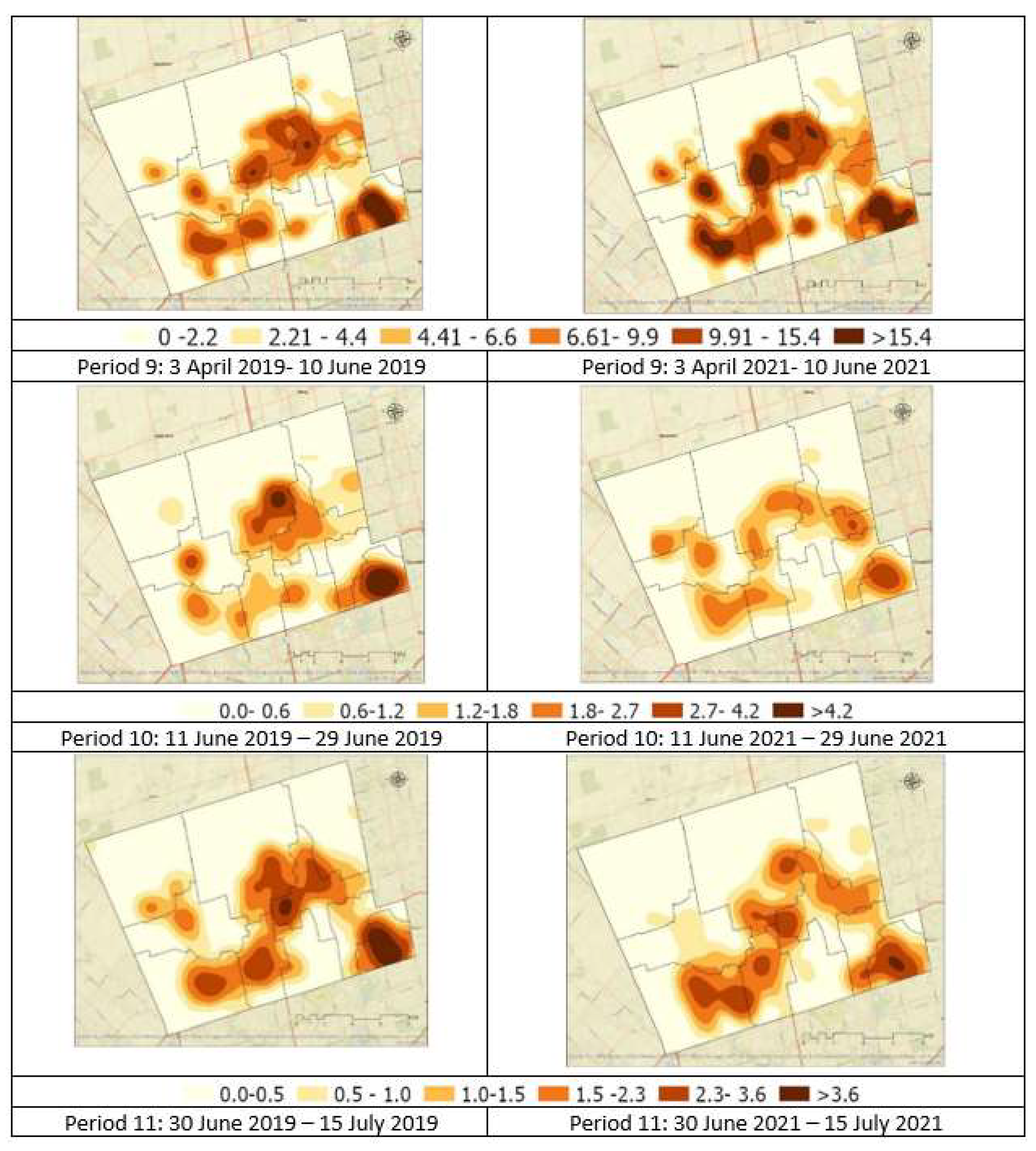
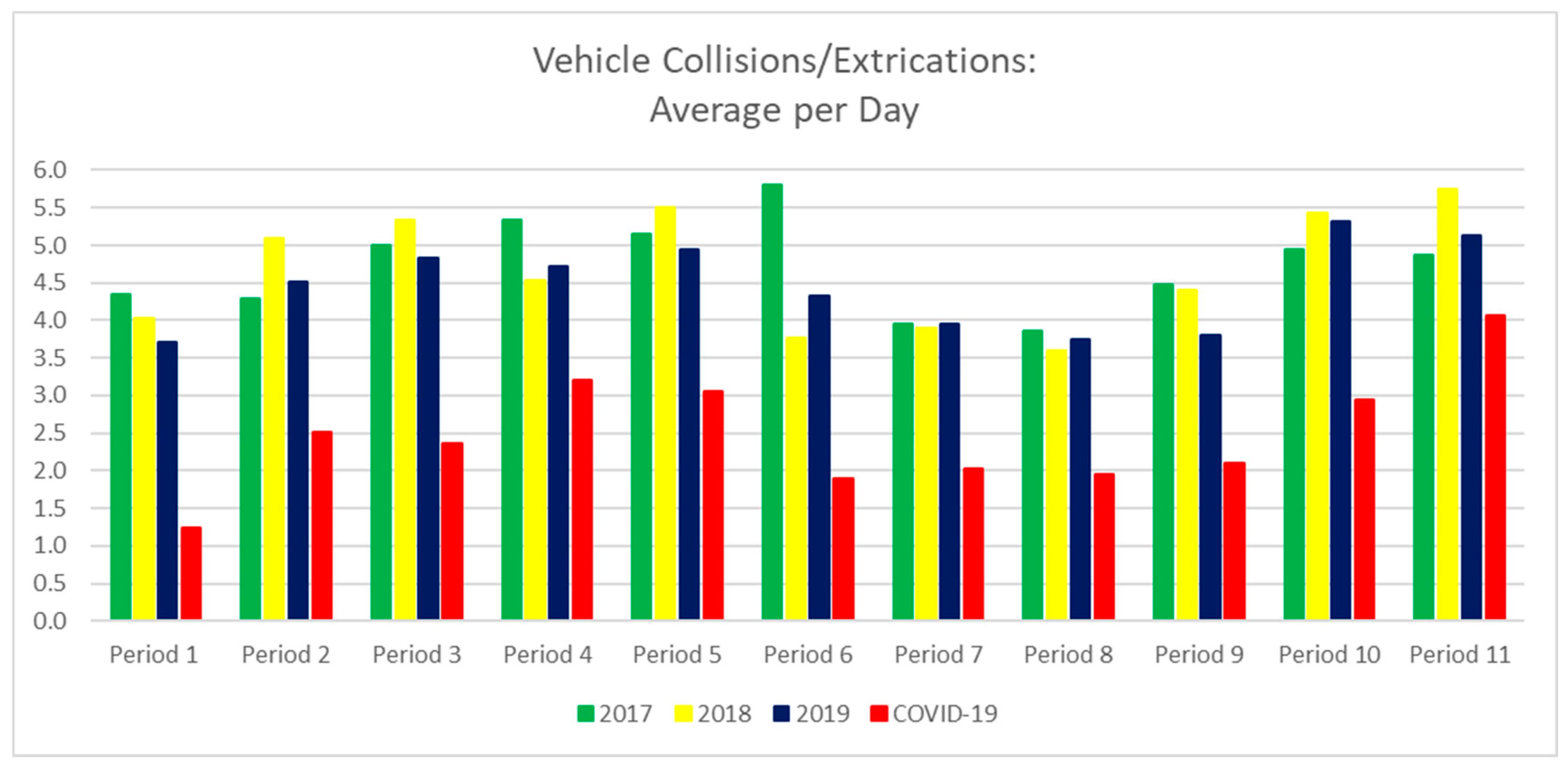
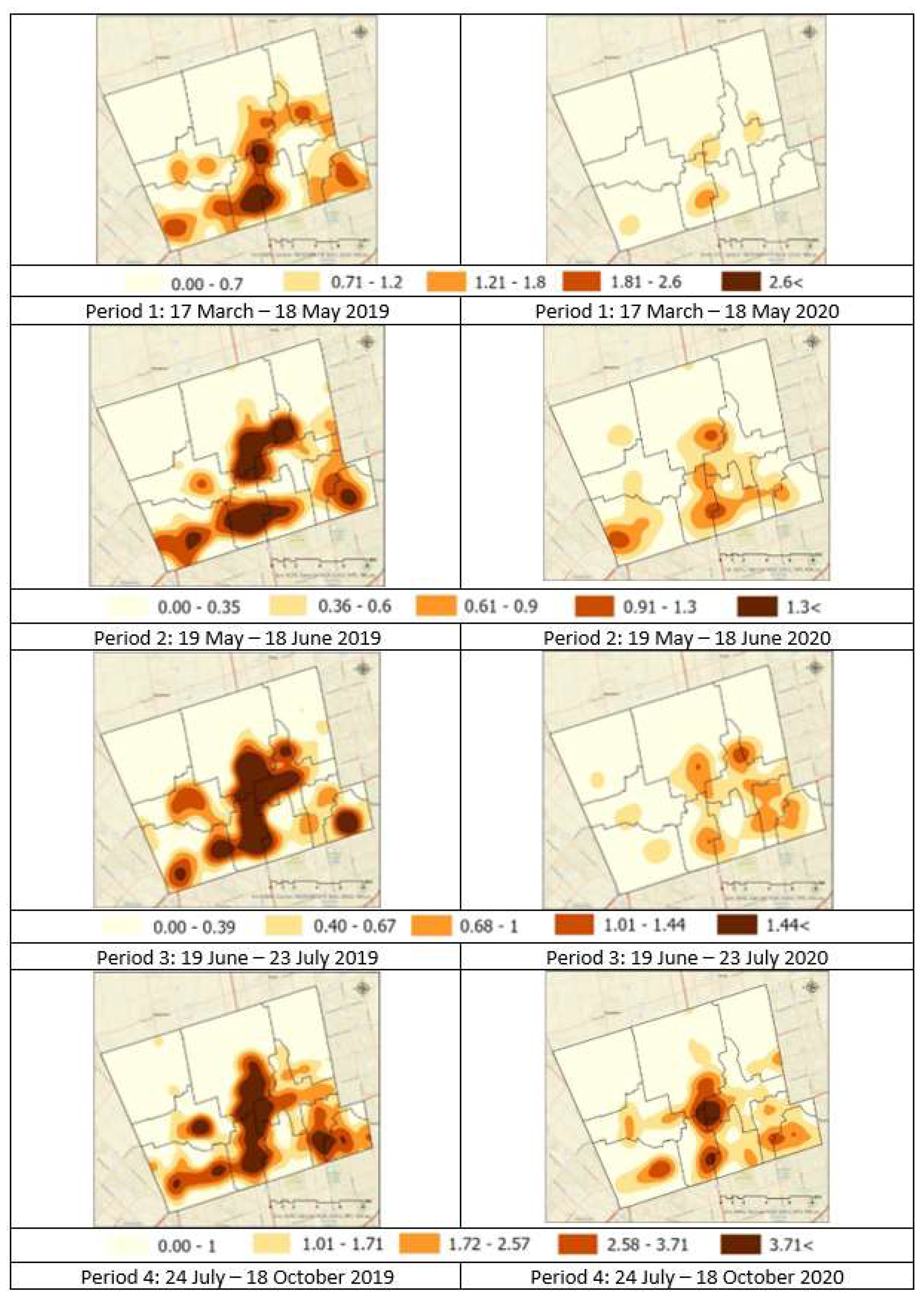

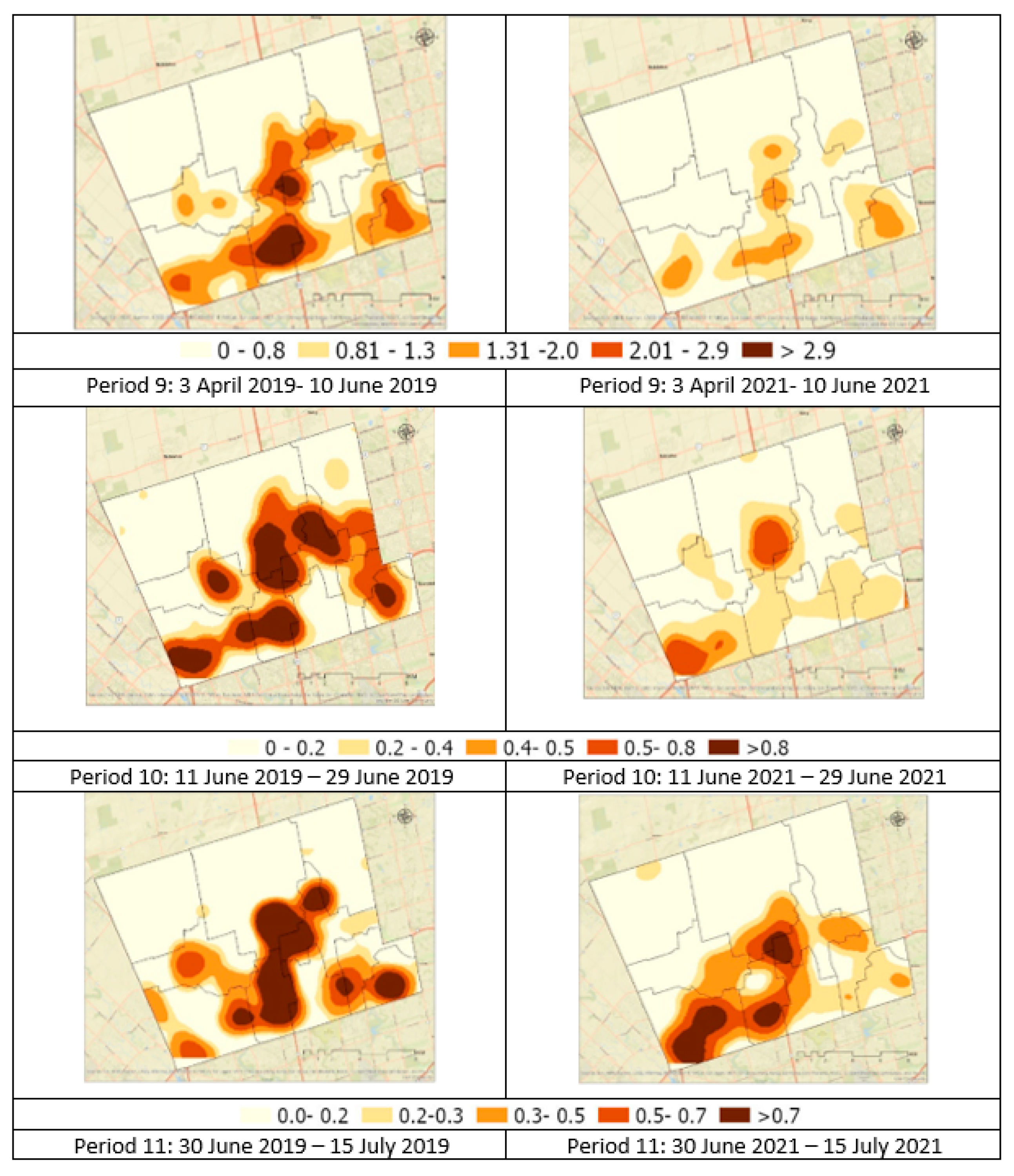
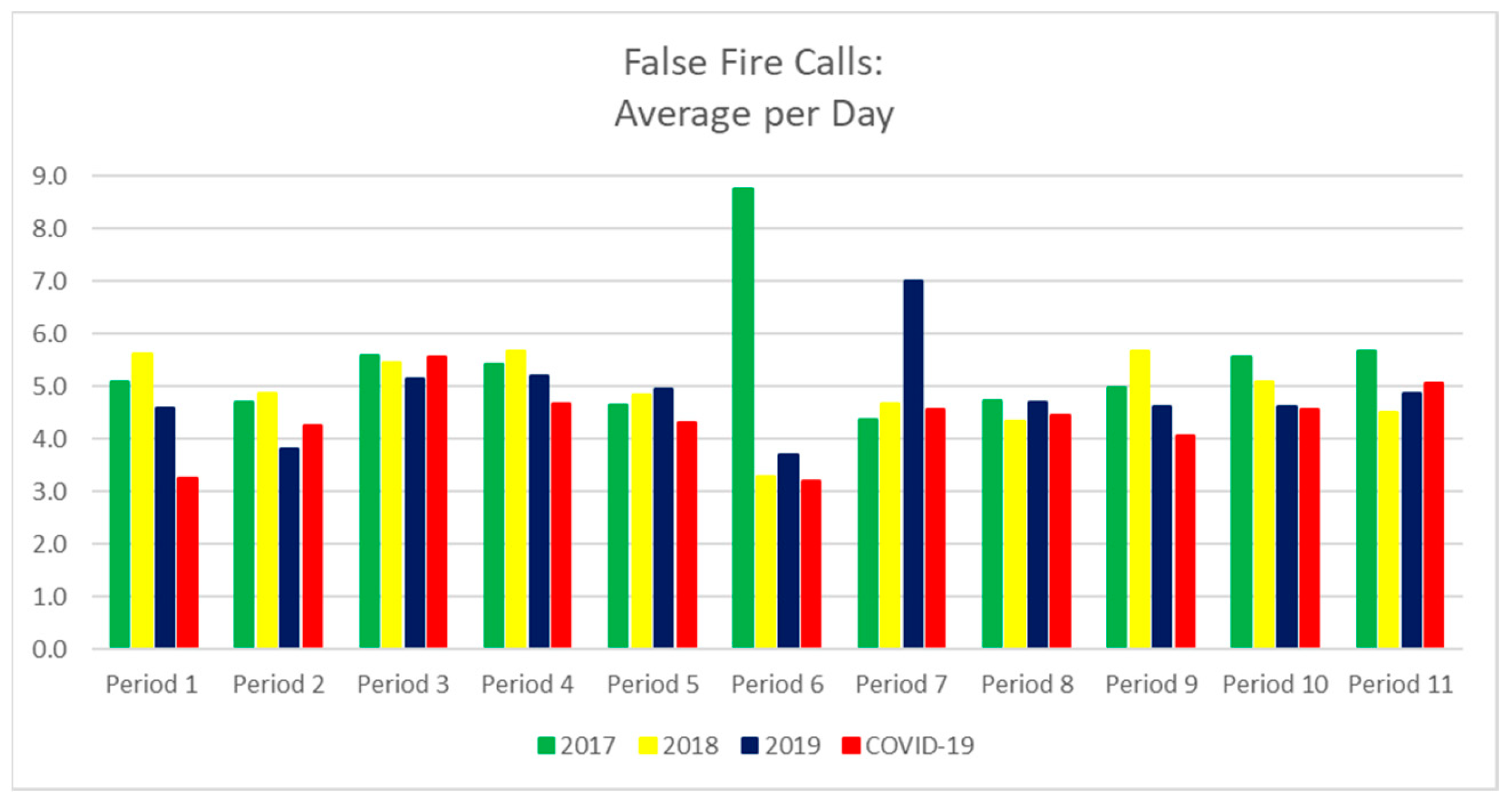
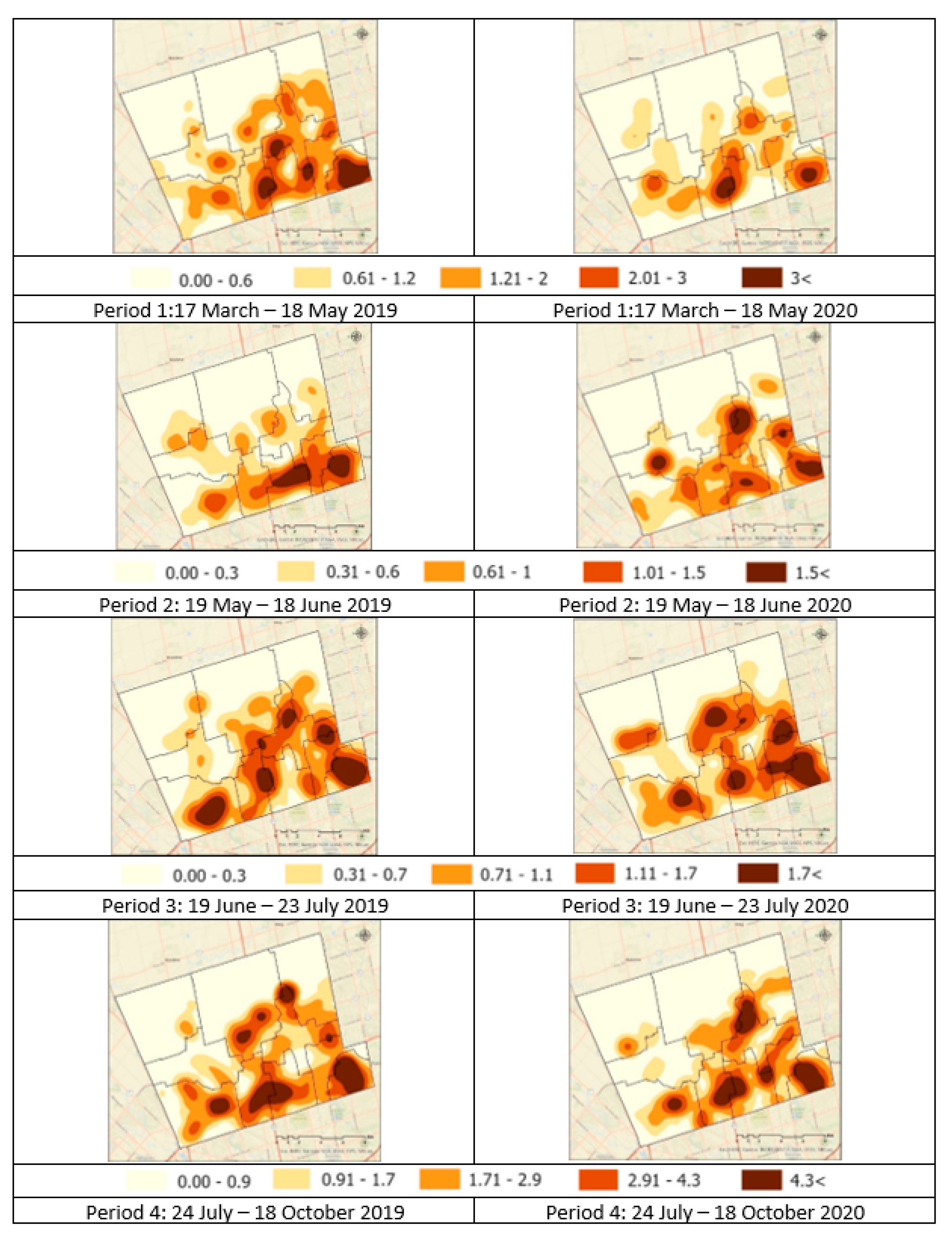
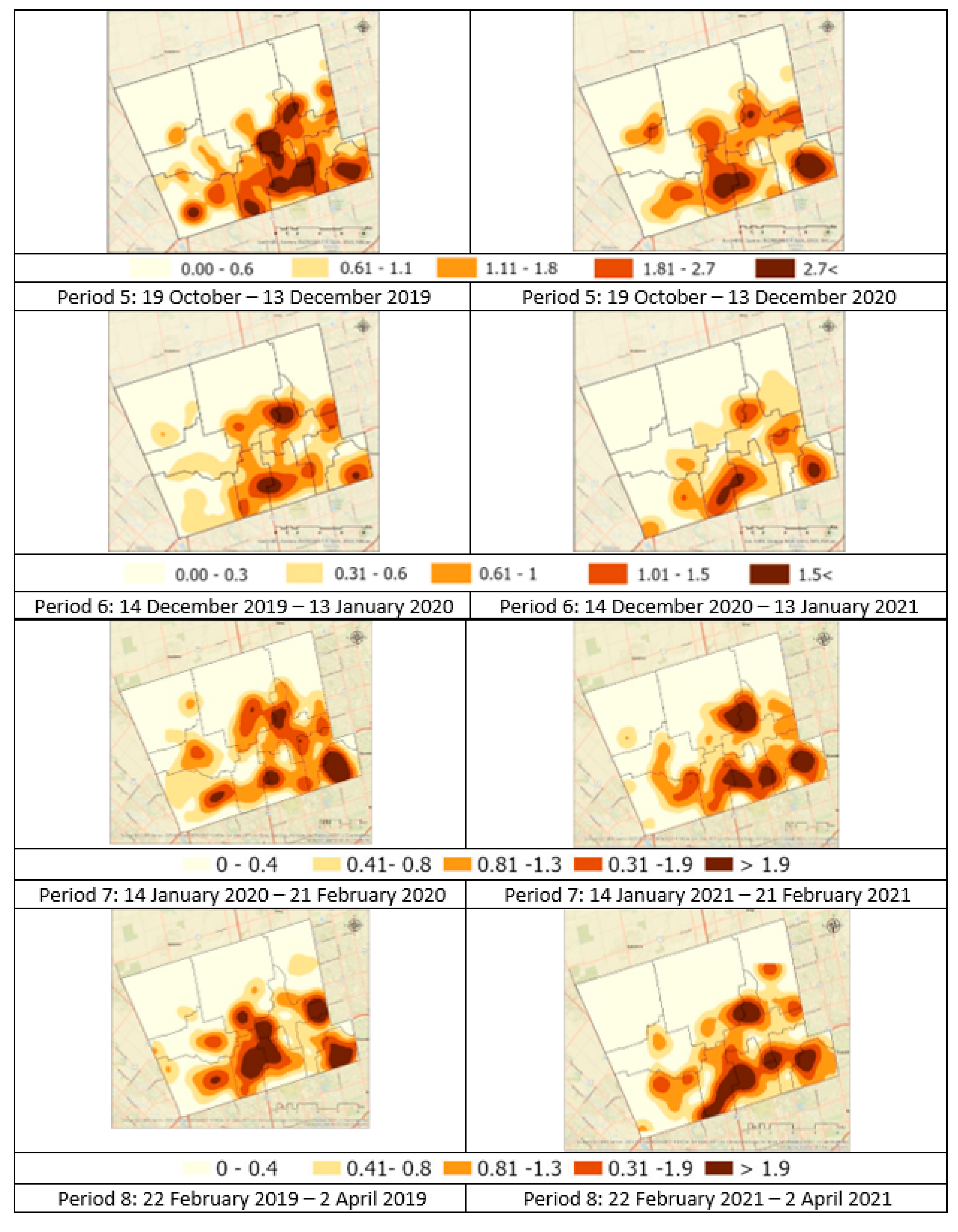
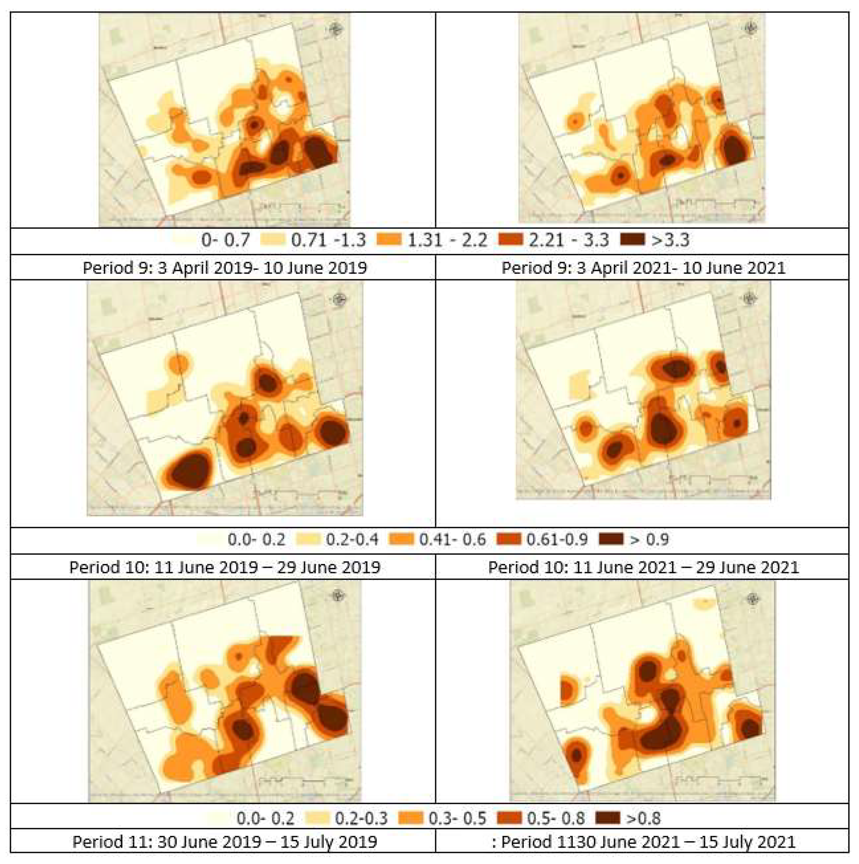
| Period | No. of Days | Brief Description of Period | Reference(s) |
|---|---|---|---|
| Period 1 (17 March–18 May 2020) | 63 | State of Emergency I (lockdown began) | [20] |
| Period 2 (19 May–18 June 2020) | 31 | Stage 1 reopening | [21] |
| Period 3 (19 June–23 July 2020) | 35 | Stage 2 reopening | [21] |
| Period 4 (24 July–18 October 2020) | 87 | Stage 3 reopening | [22] |
| Period 5 (19 October–13 December 2020) | 56 | Modified Stage 2 reopening | [23] |
| Period 6 (14 December 2020–13 January 2021) | 31 | York Region lockdown | [24,25] |
| Period 7 (14 January–21 February 2021) | 39 | State of Emergency II: Stay-at-home order | [26] |
| Period 8 (22 February–2 April 2021) | 40 | York Region as a ‘red zone’ | [27] |
| Period 9 (3 April–10 June 2021) | 69 | ‘Stay-at-home’ order; initially ‘emergency brake’ order | [28,29] |
| Period 10 (11 June–29 June 2021) | 19 | Step 1 of Province of Ontario’s Roadmap to Reopen | [30] |
| Period 11 (30 June–15 July 2021) | 16 | Step 2 of Province of Ontario’s Roadmap to Reopen | [31] |
| Pattern | Pattern Name | Pattern | Pattern Name |
|---|---|---|---|
 | New Hotspot |  | New Cold Spot |
 | Consecutive Hotspot |  | Consecutive Cold Spot |
 | Intensifying Hotspot |  | Intensifying Cold Spot |
 | Persistent Hotspot |  | Persistent Cold Spot |
 | Diminishing Hotspot |  | Diminishing Cold Spot |
 | Sporadic Hotspot |  | Sporadic Cold Spot |
 | Oscillating Hotspot |  | Oscillating Cold Spot |
 | Historical Hotspot |  | Historical Cold Spot |
 | No Pattern Detected |
| Period | No. of Days | 2017 | 2018 | 2019 | Average 2017–2019 | During COVID-19 |
|---|---|---|---|---|---|---|
| Period 1 (17 March–18 May 2020) | 63 | 1933 | 2013 | 1821 | 1922.3 | 1476 |
| Period 2 (19 May–18 June 2020) | 31 | 989 | 1073 | 974 | 1012.0 | 873 |
| Period 3 (19 June–23 July 2020) | 35 | 1094 | 1157 | 1139 | 1130.0 | 986 |
| Period 4 (24 July–18 October 2020) | 87 | 2790 | 2829 | 2705 | 2774.7 | 2466 |
| Period 5 (19 October–13 December 2020) | 56 | 1699 | 1822 | 1694 | 1738.3 | 1570 |
| Period 6 (14 December 2020–13 January 2021) * | 31 | 1223 | 861 | 957 | 1013.7 | 854 |
| Period 7 (14 January–21 February 2021) | 39 | 1084 | 1208 | 1363 | 1218.3 | 1044 |
| Period 8 (22 February–2 April 2021) | 40 | 1196 | 1153 | 1171 | 1173.3 | 1104 |
| Period 9 (3 April–10 June 2021) | 69 | 2122 | 2292 | 2099 | 2171.0 | 2236 |
| Period 10 (11 June–29 June 2021) | 19 | 654 | 628 | 589 | 623.7 | 549 |
| Period 11 (30 June–15 July 2021) | 16 | 501 | 517 | 515 | 511.0 | 484 |
Disclaimer/Publisher’s Note: The statements, opinions and data contained in all publications are solely those of the individual author(s) and contributor(s) and not of MDPI and/or the editor(s). MDPI and/or the editor(s) disclaim responsibility for any injury to people or property resulting from any ideas, methods, instructions or products referred to in the content. |
© 2023 by the authors. Licensee MDPI, Basel, Switzerland. This article is an open access article distributed under the terms and conditions of the Creative Commons Attribution (CC BY) license (https://creativecommons.org/licenses/by/4.0/).
Share and Cite
Asgary, A.; Solis, A.O.; Khan, N.; Wimaladasa, J.; Shafiei Sabet, M. Spatiotemporal Analysis of Emergency Calls during the COVID-19 Pandemic: Case of the City of Vaughan. Urban Sci. 2023, 7, 62. https://doi.org/10.3390/urbansci7020062
Asgary A, Solis AO, Khan N, Wimaladasa J, Shafiei Sabet M. Spatiotemporal Analysis of Emergency Calls during the COVID-19 Pandemic: Case of the City of Vaughan. Urban Science. 2023; 7(2):62. https://doi.org/10.3390/urbansci7020062
Chicago/Turabian StyleAsgary, Ali, Adriano O. Solis, Nawar Khan, Janithra Wimaladasa, and Maryam Shafiei Sabet. 2023. "Spatiotemporal Analysis of Emergency Calls during the COVID-19 Pandemic: Case of the City of Vaughan" Urban Science 7, no. 2: 62. https://doi.org/10.3390/urbansci7020062
APA StyleAsgary, A., Solis, A. O., Khan, N., Wimaladasa, J., & Shafiei Sabet, M. (2023). Spatiotemporal Analysis of Emergency Calls during the COVID-19 Pandemic: Case of the City of Vaughan. Urban Science, 7(2), 62. https://doi.org/10.3390/urbansci7020062


