Article

The Traditional Enjoyment of Noted Natural Places in Urban South Korea

Graduate School of Agricultural and Life Sciences, The University of Tokyo, 1-1-1, Yayoi, Bunkyo-ku, Tokyo 113-8657, Japan
*
Author to whom correspondence should be addressed.
Urban Sci. 2019, 3(3), 92; https://doi.org/10.3390/urbansci3030092
Submission received: 5 July 2019 / Revised: 31 July 2019 / Accepted: 13 August 2019 / Published: 16 August 2019

Abstract

:
Records indicate the existence of noted natural places, where several people from various classes used to enjoy the natural environment in a part of present-day city of Seoul during the Korean Dynasties period. This study aimed to clarify the traditional methods of enjoying noted natural places in South Korea’s urban areas by classifying the relationship between the method of enjoyment and the locations of the noted natural places, including their geomorphological features. Literature analysis was employed, and 29 noted natural places were extracted from the descriptions and pictures of old documents. The results revealed that six types of scenery—plants and mountain streams—were enjoyed and the ways of enjoying were classified into 15 subtypes. Additionally, the methods of enjoyment were related to five types of geomorphological features, including mountain streams and rivers, high grounds, etc. In conclusion, it was determined that a combination of scenery and geomorphological features determined the methods of enjoying noted natural places. Knowledge on the relationship between traditional methods of enjoyment and location types is considered to provide important findings to provide urban citizens with various methods of enjoyment and more effectively develop and utilize urban green spaces.

1. Introduction

The South Korean capital of Seoul has a large population, and its forests in the periphery of the city center are used extensively by its citizens. Contact between people and nature has existed since ancient times. This contact primarily occurs at valleys, the feet of mountains, rivers, and city squares. In the Korean Dynasties period (1392–1910), noted urban natural places [1] with great scenery were used, and several records remain of people from different classes and ranks enjoying a variety of activities throughout the four seasons. Not only did the urban citizens of that time admire the flowers, the mountain streams, the moon, and the winter landscapes of these noted natural places merely for their excellent scenery, but they also wrote poetry and enjoyed food and drink, and tried to plant flowering trees, as well as protect the trees and shrubs. Thus, urban South Korea’s noted natural places have a history of utilization and management.
However, in modern times, the potential value of topography is ignored, and the nature and greenery on offer are being homogenized [2]. Moreover, the methods of enjoying nature have been simplified to contact with nature in the urban and artificial environments [3].
In recent years, there have been movements to change the systems related to urban natural places, and opinions [4] that offer a deeper understanding of the integral value of these places are essential. Urban natural areas have various values depending on their location and condition, such as aesthetic value, historical value, scientific value, social value, communal value, and so on [5].
To determine the diversity of the population’s connectedness with nature, it is important to permit a variety of uses, grasp the usage of urban natural places diachronically, and understand the historical course of events, rather than offer a uniform way of using these spaces [6].
The roles of urban natural places have changed due to social conditions and historical contexts. Thus, it is necessary to understand the historic processes underlying how people enjoyed urban natural places. Then, it is necessary to identify the current problems and connect them to policy.
Above all, sustainably managing these environments requires that citizens plan for conservation and understand their various values while enjoying these familiar natural spaces. In this way, a virtuous circle in which urban residents deepen their awareness and understanding of the diverse values of urban natural areas and enjoy these areas in various ways, according to their locations and circumstances, thereby enhancing the quality of life of the people and the landscape’s quality [7].
It is possible that references to the enjoyment of natural places in city outskirts, with a focus on seasonal scenery, are a characteristic and important aspect in the relationship between people and nature in East Asia. To consider the modern issues surrounding urban green spaces in Japan, studies have been conducted since the 1990s on the spatial characteristics of, and people’s activities in, noted natural places in the Edo period (17th–19th Century), when there was an abundance of contact with nature. One of the best examples can be found in Ono [8]. Ono examined how and where people in the Edo period engaged with nature to discuss the topic of "how to spatialize the relations among nature, human, and culture", which is difficult to define in the framework of modern rationalism. The results of Ono’s study showed that scenery, such as flowers, insects, and grass, is what determines the enjoyment of a natural place. Ono also showed that there are various natural places for enjoyment in each season. Furthermore, other studies have been made to identify the attractiveness of such environments, as well as their locational or geographical characteristics, by focusing on the fact that attractions during the Edo period represented the unique cultural characteristics of Japan before the cityscape had been changed due to industrialization. These studies also provide implications for these changes and examine the original sights of nature while planning recreation sites in nature, such as forest areas near the cities [9,10,11].
In the context of existing knowledge of people’s traditional contact with nature in the noted natural places of Hanyang (part of present-day Seoul), the following studies exist. Hwang [3] and Park [12] defined the distribution of attractions from the Joseon dynasty to the present to understand the enjoyment culture and attractive characteristics in Korea and identified various changes of places for enjoyment, from nature in the past to more modern elements in the present, due to industrialization and urban development. Since the 2000s, there has been a continuous stream of studies [13,14] that define the types of natural landscapes and identify their values or original forms through an examination of old literature, to suggest the importance of conservation and provide implications for future urban development. There have also been studies [15,16] that seek to provide insights for urban planning and modern enjoyment by identifying the landscape, attraction points, and utilization behavior by analyzing old literature on attractions with particular themes or natural landscapes.
Understanding the ways in which Hanyang’s noted natural places were enjoyed historically can also be meaningful, by examining the national character elements of the urban citizens’ enjoyment in natural places and Seoul’s topographical and geographical features. With the above consideration and awareness of the issue, this study has the following two objectives: to understand and classify urban citizens’ enjoyment in natural places and to study the relationship between topography and enjoyment, with a focus on topography as the scenery in which noted natural places are established.

2. Research Methods

This study extracted urban citizens’ enjoyment, and the characteristics, of the environment in each of the noted places described in the old documents and clarified how people enjoyed these places in the late Joseon Dynasty. For descriptions of the noted places around the city where many people visit for recreation, old documents, including eight scenic poems, eight scenery maps, geographical descriptions, and Gasa Literature, were used. This research method, analyzing old documents as research materials, has been used to rationally understand how people enjoyed and used land in eras when people and nature coexisted. This method has been used in Korea and Japan.
Through this methodology, this study tried to understand the relationship between as citizen’s enjoyment and the topography in Hanyang, the capital of Korea, in the late Joseon period. Hanyang is a part of present-day Seoul and is said to have formed a city similar to the present one during the late Joseon period. In 1789, Hanyang was a city where 190,000 people lived in an area of about 20 km2. Many documents and materials describe the lives and the culture of the city residents in various hierarchies at that time. In addition, Hanyang features a variety of topographic environments, including many mountains and rivers and is a suitable place for this study.

2.1. The Extraction of Sites to Be Analyzed (Noted Natural Places)

In order to extract the locations for analysis, ten old documents, which introduce places for recreation, leisure, and play in Hanyang during the late Joseon Dynasty, were selected based previous studies [17,18,19,20], using the categories of “noted sights”, “scenic spots”, “landscape”, “recreation”, and “leisure” (Table 1). Then, based on previous studies and related books [3,21,22,23], analysis subjects were extracted using the following steps. Noted places with uncertain locations, or those whose relationship to the surrounding area could not be determined, were excluded from the list of analysis subjects. Furthermore, after removing noted places with no information about how they were enjoyed, as well as those used for specific purposes (such as imperial courts and markets) and those used by specific social classes for royal family events or military affairs, this study determined 29 famous places mentioned in ten works from the years 1740 to 1870 as the subjects of our analysis.

2.2. Analysis Methods

This study extracted old documents as research materials by utilizing the Korean Classics Comprehensive DB [24] to search for the name of each noted natural place. Then, previous studies [10,15,16,25,26,27] were used to conduct an analysis of the descriptions and paintings of the subject works, and poems were examined to grasp the characteristics of the scenery, usage, and position of the noted natural places selected as analysis subjects. These previous studies confirm how the people of the time enjoyed the scenery or culture by extracting and analyzing the entries on landscape elements, natural elements, behavior, and scenes from old documents. This analysis method was also most appropriate for this study. The following describes the procedure used for the analysis of scenery and usage characteristics.

2.2.1. Analysis of Scenery Characteristics

To grasp the scenery characteristics of the noted natural places, this study broadly used viewing objects, viewing methods, and seasons to understand the viewing activities in each place.
Regarding the first, the viewing object (a primary natural feature)—this study confirmed that viewpoints and visual objects are basic information. This study divided viewpoints into three categories: the cases where the names of the noted natural places are known as “viewpoints” in the old documents in Table 1, the cases where the name can be recognized from the title of literature or paintings, and the cases where the name can be recognized not from the title but from the text. This study sorted the scenic elements into artificial, natural, and climatic elements. Then, the visual object was extracted by using the title of the noted natural place or descriptions (such as “famous for____”). (Table 2c). The basis for extracting secondary natural features was using all the natural objects other than the primary natural feature that were also used as viewing objects. If more than one piece of scenery exists in a single noted natural place (such as “a” and “b” in Table 2), each piece of scenery was analyzed separately, even though the scenery belong to only one place.
As the second task of the viewing methods, this work studied and sorted the positioning of the primary natural feature and its distance from the viewer’s standpoint. The primary natural feature’s position and distance from the viewpoint were determined based on descriptions of the height of the viewpoint (Table 3) and the orientation of the line of sight in the paintings. As for the distance from the viewpoint, two different approaches were adopted. If it is possible to identify both the viewpoint and visual object (primary natural features) at this time, the actual distance was determined using Higuchi’s (1975) categorization [30] to classify the distance from the viewpoint to the visual object. If identification is not possible, descriptions on the distance (or how the scenery is seen (Table 3)) and the way the scenery is drawn in the paintings (detailed descriptions, patterned forms, etc.) were considered. If the position or the distance between the viewpoint and the visual object is clear and the interpretation of “low/level/high” or “near/middle/far” is possible, these category is counted, as in every case. Finally, regarding the third category of seasons, the specific season was identified and categorized as spring, summer, autumn, or winter when such information was available.

2.2.2. Analysis of Supplementary Activities to Grasp Usage Characteristics

Noted natural places are places that are famous for the appreciation of particular primary natural features. In such places, the actions of “looking at” the primary natural feature, such as flowers or the moon, are usually major activities. However, other activities, such as dining, drinking, and listening to music, are normally added to enrich the major activities, which are defined as ‘supplementary activities’ in this study.

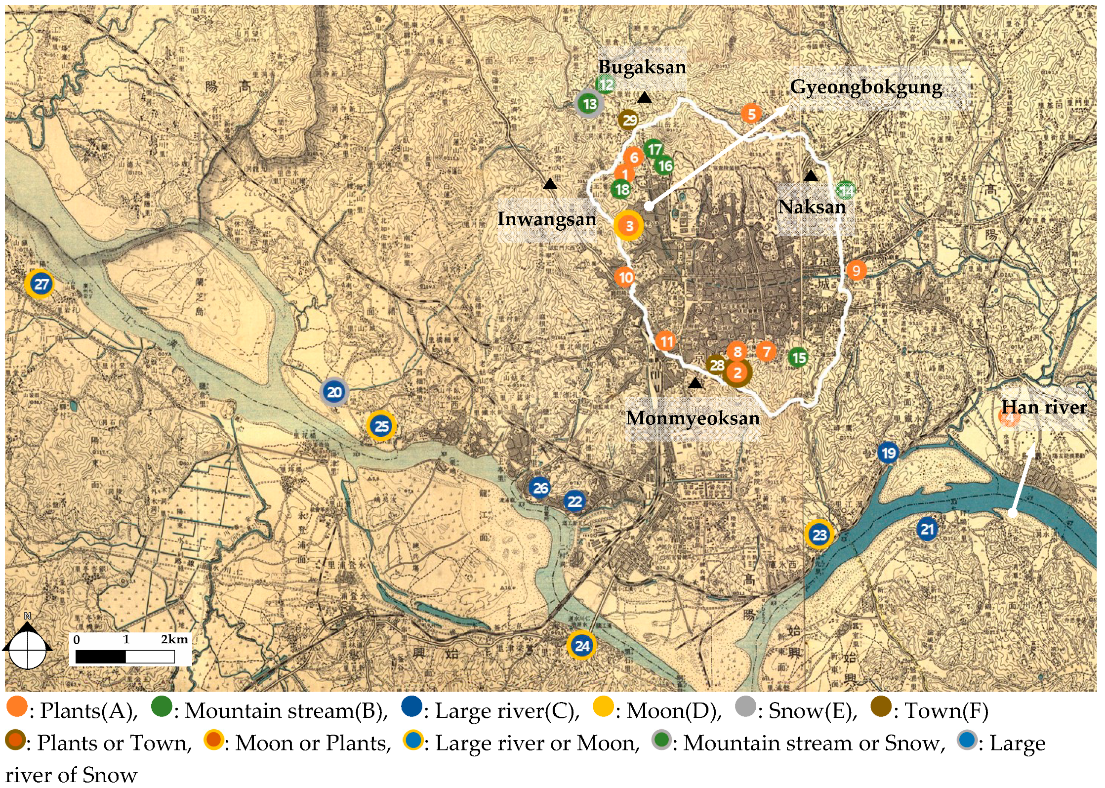
2.2.3. Distribution of Noted Natural Places and Analysis of Positioning Characteristics

To classify Hanyang’s topography, this study referred to information on the characteristics of Seoul’s mountains [31], the urban structure of Hanyang in the Korean Dynasties period [32], and the topographical classifications of landscape paintings [33,34]. In this study, based on the topographical division of previous studies, the location patterns of noted natural places were confirmed and reclassified by topographical type to understand the characteristics of the location. This study broadly categorizes the terrain as a mountain, hill, valley, river, etc. and considers the diversity of the topography, further categorizing the water scenery into more detailed categories of plains, high ground, or plateau. Finally, this research studied and sorted the correspondence between position and topography for the 29 noted natural places selected as the analysis subjects.
Through the above procedure, this study sorted the “enjoyment” of people in noted natural places and analyzed the relationships between the noted natural places and the topography in the scenery that forms them.

3. Results

3.1. Activities in the Viewing of Noted Natural Places

3.1.1. Viewing Activities

When sorting the viewing objects, this study identified and organized the natural features, separating them into primary and secondary natural features based on the description content. This resulted in six categories of primary natural features (Table 4): plants, such as apricots, peaches, willows, lotuses, other flowering trees, and autumn foliage (A), followed by mountain streams (B), rivers (C), the moon (D), snow (E), and towns (F). The categories for secondary natural features included mountains, towns, mountain streams, ponds, stones (rocks), forests, large rivers, and boats.
Upon examining the viewing method of the primary natural feature based on the relationship between the viewpoint and the viewing object, with the exception of the moon, the primary natural feature was often viewed with the viewpoint position at roughly the same height as the natural feature. Otherwise, there were many instances in which the viewpoint was relatively high, looking down on the noted natural place. However, the distance to the viewing object varied, with no uniformity, from near to middle and middle to far.
Organizing each noted natural place’s viewing object and viewing method resulted in 15 categories for viewing activities. Table 4 shows the classification of the viewing activities by primary natural feature, secondary natural feature, and viewing activity, and creates a ranking by broad categories for primary natural features (A–F), narrow categories for primary natural features (1–3), and viewing method (a–c). The most frequent viewing activity was C2-b, in which the primary natural feature was a large river, and the river scenery was viewed from a relatively high location at a middle to long distance. The next most frequent was D2, in which the moon was viewed as a primary natural feature from a high location near a large river.

3.1.2. Supplementary Activities

Regarding the usage forms of these noted natural places, in addition to activities related to seasonal customs, the activities were diverse, ranging from quiet ones, such as admiring nature, to dynamic one involving bodily movement, such as crafting and traditional games. These activities can be sorted into five categories: exercise, crafting, food, cultural, and solitary play. Specifically, the exercise category included water games, archery, playing in boats, and fishing; crafting included making willow flutes or flower buchimgae; food included eating, drinking, and banquets; cultural included composing poems, painting, reading, education, reciting, and music appreciation; and solitary play included seclusion and retiring from the world. Above all, food and cultural activities were carried out at most of the noted natural places, while exercise was carried out at places with large rivers as the primary natural feature and involved playing in boats or fishing.

3.2. Types of Enjoyment in Noted Natural Places

Upon examining the types of enjoyment in the noted natural places according to primary natural feature, if the primary natural feature was a plant and the activity was viewing flowers, two types were identified: viewing the plants at a distance and from a high viewpoint while also viewing mountains or towns (A1), and viewing the plants from a near distance, with water scenery such as mountain streams or ponds as secondary natural features (A2-a,b, A3). These viewing activities were related to seasonal changes, and flower-viewing was accompanied by food or cultural activities, such as composing poems.
For example, Bukdun (北 屯; Place 4) was selected as a noted place for viewing flowers in the spring in such works as Hangyeong-jiryak, Kyungdo-japji, and Donggook–seshigi, while it is depicted in Yoon ki (尹愭, 1741–1826)’s Mumyungjajip『無名子集』 with peach blossoms in full bloom and a mountain stream as the viewing target (洞裏桃花滿 村中澗水馳/拂枝香襲袂 臨石影搖池/眼醉何須酒 神癡未暇詩/遊人喧日夕 俱是樂平時).
Furthermore, noted places with mountain streams as the primary natural feature often involved listening to the sounds of the stream from a relatively close distance while also viewing stones and the stream (B1-a, b, c). For supplementary activities, cultural activities were common in addition to food. For example, in “Chunghuigak (晴暉閣)” by Nam Yong-ik (南龍翼, 1628–1692) in Hogok jip『壺谷集』, Chunghuigak (晴暉閣; Place 18)’s position is appreciated as a subtle, mysterious place because of the mist and evening glow and is depicted using lush mountain thunder as a metaphor for the sound of a waterfall, along with willow leaves, fish, and the song of a nightingale.
Additionally, three of the noted places have a large river as their primary natural feature, viewed from a high place far away, along with mountains, rocks, and boats, with food-filled banquets, cultural activities, and playing in boats as supplementary activities (C2-b). There was also a noted place in which rocks were viewed from a relatively nearby close- or middle-distance along with mountains viewed farther away, with fishing as an activity (C1). For example, Seo Geo-Jeong’s (徐 居 正, 1705) “立石釣魚” in Hando-sibyoung『漢都十詠』 depicts someone enjoying fishing while viewing stones along a riverbank (溪邊怪石如人立/秋水玲瓏照寒碧/把釣歸來籍綠蕪/百尺銀絲金鯉躍/細斫爲膾燖爲羹/沙頭屢臥雙玉甁... [abridged]).
Moreover, snow and the moon appear as temporary, passing pieces of scenery representing nature and time periods, as they can only be viewed depending on the season. In a noted place with the moon as the primary natural feature, the viewing activity occurs alone while on a boat, with the supplementary activities of drinking alcohol and composing poetry. Furthermore, in addition to a scene that primarily includes facilities like towers and pavilions on high ground near a large river, in which the viewing activity was looking up at the moon in the sky above as well as looking down at the reflection of the moon on the water, there were scenes in which the viewer was looking at a noted place (Places 23–27) afar from a high place on a mountain, or looking at the mountains and the moon from Pilundae (弼雲臺; Place 3). For example, in Jeong Yak-yong’s (丁 若 鏞; 18th–19th century) “同諸友乘舟至月波亭汎月” in Dasan’s anthology『茶山詩文集』, a figure is depicted as arriving at Place 24 in a boat with a close friend and enjoys playing in the boat at night, drinking alcohol, singing, and looking at fish (月波亭下扁舟泊/墟里煙生日初落/登樓飮酒下樓歌/時見潮頭大魚躍...中略...俄看天際玉輪涌/玻瓈碾碧澄泓長... [abridged]).
On the other hand, the noted places with snow as a primary natural feature involved viewing a snow-covered scene in a vast area from roughly the same height (E1) and viewing a frozen mountain stream (E2) from a nearby location or a higher viewpoint. In particular, the latter scene involved looking at the primary natural feature of snow from a high viewpoint in a pavilion, with the supplementary activities of eating, drinking, and cultural activities, while the former did not emphasize any particular secondary natural features, emphasizing instead the snow itself. Jeongjo, the 22nd ruler of the Korean Dynasties period, visited Saegumjeong (洗劍亭; Place 13), viewed a frozen waterfall, and bequeathed a composition (洗劍亭前百道氷 懸崖倒壑雪霜凝 琉璃錯布三千界). Furthermore, Yanghwajin (楊花津; Place 20) has been known for its snowy scenery since the time of the early Korean Dynasties, and it is said that people would enjoy stepping in the snow while looking out at the spacious, snow-covered riverbed (楊花踏雪).
Finally, in noted places where towns are the primary features, the city of Hanyang is the viewing object, with the mountains as the backdrop. In addition to the supplementary cultural activities, a bird’s-eye view of the everyday city was enjoyed without any specific supplementary activity. For example, Lee Yu-won’s (李裕元; 1814–1888) Imhapilgi『林下筆記』describes how “Chilsongjeong (七松亭; Place 29) is a perfect for climbing and gazing afar”.

4. Discussion: Relationship Between the Positioning, Scenic Structure, and Enjoyment of Noted Natural Places

4.1. Distribution and Positioning of Noted Natural Places

With mountains to its north, south, east, and west (Naksan is at 125 m above sea level, Inwangsan at 328 m, Monmyeoksan at 265 m, and Bugaksan at 342 m), Hanyang has a basin topography surrounded by the ridgelines of ranges formed by these continuous mountains. Outside of this, a ridge over 700 m high runs along the northern border, while a wide river runs from east to west along the south side. In addition to this, diverse types of land undulations create a variety of topographies, with noted places positioned within this terrain. Figure 1 plots the positions of each noted natural place on an enlarged section of a map published by the governor-general’s bureau in 1918 and illustrates the distribution of these places. On the whole, noted natural places were confirmed in the mountains surrounding Hanyang. Furthermore, there are many noted natural places distributed along the large river on the south side.
To classify topographical type, Hanyang’s topography was studied and sorted into plains, high ground or plateaus, valleys, rivers, and large rivers, with the additional classification of valleys into profound valleys or other types. Of the 29 noted natural places, 12 were positioned on high ground or plateaus, which were the largest categories. The next category was valleys, in which 11 noted natural places were located, with six of these places positioned in particularly profound valley topographies. The other categories were three places in plains, two close to rivers, and one close to a large river.

4.2. Relationship Between the Positioning, Scenic Structure, and Enjoyment of Noted Natural Places

Examining the relationship between the positions of each noted natural place and its viewing object, viewing method, and supplementary activities reveals that Hanyang has large and small mountains, as well as valleys, in its surroundings, and many of its noted natural places include water as a primary natural feature. Thus, several of its noted natural places have a scenic structure that includes a combination of natural features, along with stones, rocks and or water as a secondary natural feature. Table 5 shows the types of enjoyment by topographical categories.
Looking at the noted natural places by their positions, and beginning with places positioned on high ground or plateaus, the viewpoint did not involve movement but was set on a fixed high ground, and activities took place with the viewpoint and the viewpoint location were clearly established. Furthermore, the following viewing activities took place: looking down at flowers in the city during spring (A1); setting up facilities, such as towers or pavilions, at high places near a large river and viewing the natural scenery, including the river (C2-b); viewing the moon as a primary natural feature (D1,2); and viewing the town and mountains from afar (F1). Meanwhile, drinking alcohol, composing poetry, singing, and other cultural activities were conducted while viewing the scenery.
Next, in the noted places positioned in profound valleys, the nearby scenery of plants and mountain streams became the viewing objects due to the unique topography, featuring an intimate sense of nearness with the surrounding environment (A2-b, B1-c). In these types of places, there were buildings, such as towers and pavilions, and the supplementary activities included not only cultural but also solitary ones. On the other hand, noted places positioned close to streams at the foots of mountains allowed one to view the surrounding stones, with the stream itself forming the primary natural feature (B1-a,b). Furthermore, as wide valleys and rivers have features that are not found in the topography of profound valleys, the scenery was viewed from a moving standpoint, such as while walking (A2-a).
For noted places located in plains, plants in the foreground became the primary natural feature and were viewed along with stones (A3). In addition to food and cultural activities, the supplementary activity of crafting was carried out.
Additionally, in noted places with vast rivers, the river itself was viewed as the primary natural feature, with mountains and rocks forming viewing objects in the background (C2-a). As a seasonal natural feature, snow on the vast river also became a viewing object (E1). In addition to these, noted places near smaller rivers were viewed along with mountains and rocks (C1), and in noted places with fields spreading around the river, plants, and mountain streams were viewed (A2-a).

5. Conclusions

In this study, using the case of Hanyang, the traditional types of enjoyment of natural spaces for urban citizens were studied and sorted, and the relationship between topography and enjoyment was revealed. Seoul has an undulating landscape, located in a topographically diverse basin. In the former city of Hanyang, a part of present-day Seoul, it seems that nature was enjoyed by selecting the type of enjoyment activity to match the topographical characteristics. From the results, six types of natural features, such as plants, mountain streams, and large rivers, as well as 15 categories of enjoyment, were studied and categorized. The noted places were linked with five categories of positioning, including mountain streams, large rivers, and high grounds or plateaus. It is conceivable that the combination of natural features and topography determined the types of enjoyment activities in the noted natural places. In recent years, as mentioned in the introduction, fairness in opportunities and the homogeneity of residents have been considered more important than the potential of one’s location in nature and the maintenance of greenery. However, the results of this study show that during the late Joseon Dynasty, Hanyang citizens selected different noted natural places each season and had different ways of enjoying them according to the characteristics of the particular places. Such knowledge on the relationship between traditional methods of enjoyment and location type is considered to provide urban citizens with various methods of enjoyment and more effectively develop and utilize urban green spaces in the future. In addition, it is thought that the relationship between traditional methods of enjoyment and positioning characteristics are different from country to country. It is possible to compare and understand the prototypes and features of enjoyment in natural places of each country by confirming where and how people enjoyed nature traditionally. The methodology used in this study is considered to be effective in determining how to enjoy the urban green spaces in each country
Finally, this study would like to suggest some tasks for future research. Because of the difficulty in obtaining data for the everyday enjoyment of people, this study was unable to cover the topic of enjoyment according to social classe. Furthermore, more research will be needed to determine whether the results of a study focused on Hanyang can be generalized for Korea. However, in the space that was once called Hanyang, many people used the natural environment as it was without changing the topography. They encountered and fully enjoyed nature in various ways. This suggests a diversity of uses for these noted places. Further collection of data and proposals for system theories in the modern era are needed in order to develop a planning theory to develop functions for urban natural spaces. These are topics that we would like to address in the future.

Author Contributions

Conceptualization, E.P. and A.S.; methodology, E.P. and A.S.; software, E.P.; validation, A.S. and K.Y.; formal analysis, E.P.; investigation, E.P.; data curation, E.P.; writing—original draft preparation, E.P.; writing—review and editing, A.S., K.W.N., and K.Y.; supervision, A.S.

Funding

This research was funded by JSPS KAKENHI Grant Numbers JP18K05703.

Conflicts of Interest

The authors declare no conflict of interest.

References and Notes

  1. In this study, places considered as famous places in Hanyang were visited by numerous people to enjoy nature, go on excursions, experience leisure time, and play; places with exceptional scenery; and places that inspired poetry. These are referred to here as “noted natural places.”.
  2. Kuwano, S. Parks and communities in European civilization—A proposal for the growth of “citizens’ publicity” in Japan. Bull. Koriyama Women’s Univ. 2018, 54, 249–259. [Google Scholar]
  3. Hwang, K.W. The Leisure and Outdoor Recreation Culture of Korea; Seoul National University Press: Seoul, Korea, 2009. [Google Scholar]
  4. Chae, J.H. Change of Pluralistic Value in Mt. Gwanak as Suburban Mountain: Interdisciplinary Doctoral Program in Landscape Architecture Major; Graduate School, Seoul National University: Seoul, Korea, 2016. [Google Scholar]
  5. Dastgerdi, A.S.; De Luca, G. Specifying the significance of historic sites in heritage planning. Conserv. Sci. Cult. Herit. 2018, 18, 29–39. [Google Scholar]
  6. Yoshinaga, A. Urban Environment and Public Sphere—Implications for Environmental History Research. J. Public Aff. 2005, 2, 285–298. [Google Scholar]
  7. Grifoni, R.C.; D’Onofrio, R.; Sargolini, M. Quality of Life in Urban Landscapes; Springer: Berlin/Heidelberg, Germany, 2018. [Google Scholar]
  8. Ono, S. City People’s Recreation in the Edo Period. Jpn. Inst. Landsc. Archit. 1990, 57, 143–150. [Google Scholar]
  9. Taninaka, H. Fundamental Problems on the Planning of Suburban Recreational Woods. Jpn. Inst. Landsc. Archit. 1990, 53, 263–268. [Google Scholar] [CrossRef]
  10. Hanyu, F. A Study on the Formation and the Maturity of the Sights in Edo city—Through the analysis of the attraction and the special composition of the Sights. J. City Plan. Inst. Jpn. 2004, 39, 115–120. [Google Scholar]
  11. Mitsuke, M. Style of Japan Observed in The Public Park a Transition from Edo Period; Hosei University: Tokyo, Japan, 2018. [Google Scholar]
  12. Park, S.J. The Transitional Characteristics of Landscape & Attractions in Seoul, through Analysis of the Landscape Associated Texts; University of Seoul: Seoul, Korea, 2015. [Google Scholar]
  13. Park, C.W.; Lee, Y.H.; Kim, J.J. The Types and Characteristics of Natural Scenery in Landscape Painting during Joseon Dynasty. J. Korean For. Soc. 2014, 103, 687–695. [Google Scholar] [CrossRef] [Green Version]
  14. Kim, Y.H. Study on the Landscape Characteristics of Waterfront in Real Landscape Painting. Master’s Thesis, Dong-a University, Busan, Korea, 2017. [Google Scholar]
  15. Lee, J.I.; Sung, J.S. A Study on Landscape Characteristics of Flower-viewing Sites through Historical Literatures in the Late Joseon Dynasty. J. Korean Inst. Tradit. Landsc. Archit. 2016, 34, 35–44. [Google Scholar] [CrossRef] [Green Version]
  16. Gill, J.H.; Son, Y.H.; Hwang, K.W. A Study on the Cultural Landscape around Lotus Ponds of Fortress Wall of Seoul through Old Writings in the Joseon Dynasty. J. Korean Inst. Tradit. Landsc. Archit. 2016, 34, 1–17. [Google Scholar] [CrossRef] [Green Version]
  17. Park, S.J.; Kim, H.B.; Lee, S.H. The Comparative Study on the Landscape Attractions of Seoul in Joseon Dynasty: Focusing on the Eight Scenery Poems. True-View Landsc. Paint. Folk. Lit. Korea Res. Inst. Hum. Settl. 2014, 82, 17–35. [Google Scholar]
  18. Cho, K.H. Transition: Two Modes of Landscape Painting in Early Eighteenth-Century Korea. J. Art Hist. Vis. Cult. 2006, 5, 192–232. [Google Scholar]
  19. Cho, K.H. Late Joseon Pictures of Notable Sights of Hanyang and Eight Views of Hanyang Reassessed; Soongsil University: Seoul, Korea, 2012; Volume 10, pp. 147–194. [Google Scholar]
  20. Na, H.Y. A Study on the Hanyang Myung Seung Paintings; Ewha Womans University: Seoul, Korea, 1999. [Google Scholar]
  21. Kim, Y.S. Seoul’s Scenic and Historic Places; The Seoul Special Municipal Historical Compilation Committee: Seoul, Korea, 1958. [Google Scholar]
  22. Seoul City. The 600-Year History of Seoul Vol. 1, 2, and 3; The Seoul Special Municipal Historical Compilation Committee: Seoul, Korea, 1977. [Google Scholar]
  23. Yun, C.Y. Reviewing the noted places of the west village and a true-view landscape painting of late Joseong period. Inst. Seoul Stud. 2013, 50, 69–107. [Google Scholar] [CrossRef]
  24. Korean Classics Comprehensive DB. Available online: http://db.itkc.or.kr/ (accessed on 1 February 2019).
  25. Kim, S.H. A Study on the Placeness of Pavilion of the Han River in Seoul during Chosun Dynasty; Sangmyung University: Seoul, Korea, 2014. [Google Scholar]
  26. Jung, S.Y. A Typology of Experiencing the Scenic Site during the Joseon Dynasty Era: A Case Study of Yeongseo Area; Graduate School of Korea National University of Education: Chungcheongbuk-do, Korea, 2018. [Google Scholar]
  27. Seo, J.U. Interpreting Cultural Scenery in Hanson and the Surrounding Area as Expressed in the Realistic Landscape Paintings of Jeong Seon; Korea University: Seoul, Korea, 2012. [Google Scholar]
  28. Kansong Art and Culture Foundation. Available online: http://kansong.org/ (accessed on 3 July 2019).
  29. Samseong Museum of Publishing. Available online: http://ssmop.org/ (accessed on 3 July 2019).
  30. Higuchi, T. The Visual and the Spatial Structure of Landscapes; Gihodo: Tokyo, Japan, 1975. [Google Scholar]
  31. Seoul City. Seoul’s Mountains; The Seoul Special Municipal Historical Compilation Committee: Seoul, Korea, 1997. [Google Scholar]
  32. Kwon, Y.S. The Spatial Structure of ‘Hanseongbu’ in Late Joseon Dynasty; Seoul National University: Seoul, Korea, 2003. [Google Scholar]
  33. Kang, M.S. Pattern Classification and Characteristics Concerning Landscape on Mountainas and Hills by Using a Landscape Picture—The Case of Seoul City. J. Korean Inst. Tradit. Landsc. Archit. 2001, 29, 12–23. [Google Scholar]
  34. Kang, Y.J.; Bae, M.K. Prospect Behavior in the Analysis of Kyumjae Chung Sun’s One Hundred Scenes from the Real Landscape Painting. J. Korean Inst. Landsc. Archit. 2002, 30, 1–15. [Google Scholar]
  35. Encyclopedia of Korean Culture. Available online: http://encykorea.aks.ac.kr/ (accessed on 3 July 2019).
  36. National Museum of Korea. Available online: http://www.museum.go.kr/ (accessed on 3 July 2019).
Figure 1. Distribution of noted natural places.
Urbansci 03 00092 g001
Table 1. List of ten old documents.
Work NamePeriodCategoryDocument CharacteristicsNumber of Noted Places
1Album of Gyeonggyo myeongseung
(京校名勝帖 上, 下)
1740PaintingsPaintings depicting noted places around the Han River33
2Eight Sights of Yangcheon
(陽川八景帖)
1742PaintingsPaintings depicting noted places around Yangcheon8
3Eight Sights of Jangdong
(壯洞八景帖1,2)
1755PaintingsPaintings depicting noted places of Inwangsan and Bugakusan11
4Gukdo-palkyong
(国都八詠)
c. 1800PoemsPoems with themes of typical noted places of Hanyang8
5Hangyeong-jiryak
(漢京識略)
c. 1800Book of customsRecords of noted places in Hanyang19
6Kyungdo-japji
(京都雜志)
c. 1800Book of customsRecords of people’s lifestyles and seasonal customs in Hanyang8
7Yeolyang–Seshigi
(洌陽歳時記)
1819Book of customsRecords of seasonal customs and annual events in Hanyang3
8Hanyang-ga
(漢陽歌)
1844Gasa LiteratureRecords of attractions, festivals, and daily life in Hanyang23
9Donggook–seshigi
(東国歳時記)
1849Book of customsRecords of seasonal customs and yearly events18
10Donggukmunheonbigo
(東国輿地備考)
c. 1870Book of geographyRecords of geographical facts and noted places, such as pavilions20
Table 2. Analysis examples of the noted natural places’ scenic characteristics.
a. Primary Natural Feature: Moonb. Primary Natural Feature: Sandc. Primary Natural Features: Peach, Willow
Urbansci 03 00092 i001 Urbansci 03 00092 i002 Urbansci 03 00092 i003
Soakru (小岳樓)
Jeongseon (c. 1741), 「小岳候月」
Soakru (小岳樓)
Jeongseon (c. 1741), 「錦城平沙」
Pilundae (弼雲臺)
Im Deuk-myeong (c. 1786),「登高賞花」
Source: a, b: Kansong Art and Culture Foundation [28], c: Samseong Museum of Publishing [29].
Table 3. The categories of the viewing method for the scenery and the corresponding description in the text.
CategoryDescription
Position of Primary Natural FeaturesHighName of the place, including, words such as “tower” or “pole”, indicating a high place.
Descriptions of viewing the scenery including items such as “lookdown” or “a high place”.
LevelNo description such as “look up”, “overlook“, or height
LowDescriptions of viewing the scenery, including items such as “look up”.
MixedDescriptions of viewing the same scenery simultaneously, including items such as “lookdown” and “look up”.
Distance from ViewpointFarDescriptions related to open spatial features
Descriptions of viewing the scenery, including items such as “far.”, “wide.”, “opened”
MiddleNo description such as “far” or “near”
NearDescriptions of viewing the scenery, including items such as “near”, “narrow”, or ”closed”
Detailed description about the object
MixedDescriptions of “far” and “near” occurring together
Table 4. The enjoyment and position of each noted natural place.
Place NumberPlace NameViewing ActivitySupplementary ActivitiesPosition
Viewing ObjectViewing MethodSeasonCategoryLocations
Primary Natural FeatureSecondary Natural FeatureView
Point
Distance
1Sesimdae
(洗心臺)
Plants (peach, willow)Mountain, townHighMiddle, farSpringA13Exercise, food, culturalHigh ground or plateau
2Jamdoobong
(蠶頭峰)
Plants (peach, willow)Mountain, townHighMiddle, farSpringCulturalHigh ground or plateau
3Pilundae
(弼雲臺)
Plants (peach, willow)Mountain, townHighMiddle, farSpringFood, culturalHigh ground or plateau
4Salgoji Bridge
(箭串 橋)
Plants (apricot, willow)Mountain, streamLevel, highNear, middleSpringA2-a2Food, culturalRiver
5Bukdun
(北屯)
Plants (peach)Mountain, streamLevel, highNear, middleSpringCulturalValley
6Cheongpunggye
(淸風溪)
Plants (autumn foliage)Mountain, streamLevelNearAutumnA2-b3Food, culturalProfound valley
7Hujodang
(後彫堂)
Plants (autumn foliage)Mountain, streamLevelNearAutumnFood, culturalProfound valley
8雙檜亭Plants (autumn foliage)Mountain, streamLevelNearAutumnFood, culturalProfound valley
9Dongdaemun
(興仁門)
Plants (lotus, willow)PondLevelNearSummerA33Crafting, food, culturalPlain
10Cheonyunjeong
(天然亭)
Plants (lotus, willow)PondLevelNearSummerFood, culturalPlain
11Namji
(南池)
Plants (lotus, willow)PondLevelNearSummerFood, culturalPlain
12Tangchundae
(蕩春臺)
Mountain streamStonesHighMiddleSummerB1-a2Exercise, food, culturalValley
13Saegumjeong
(洗劍亭)
Mountain streamStonesHighMiddleSummerExercise, food, culturalValley
14Hyeopganjeong
(夾澗亭)
Mountain streamStonesLevel, highNear, middleSummerB1-b2Exercise, food, culturalValley
15Cheonugak
(泉雨閣)
Mountain streamStonesLevel, highNear, middleSummerExercise, food, culturalValley
16Dongrakjeong
(獨樂亭)
Mountain streamStonesLevelNear-B1-c3Cultural, solitary playProfound valley
17Cheongsongdang
(聽松堂)
Mountain streamStonesLevelNear-Cultural, solitary playProfound valley
18Chunghuigak
(晴暉閣)
Mountain streamStonesLevelNear-Cultural, solitary playProfound valley
19Ipseokpo
(立石浦)
Large riverrockLevelNear, middle-C11Exercise, foodRiver
20Yanghwajin
(楊花津)
Large riverMountain, rock, boatLevelFar-C2-a1UnknownLarge river
21Apgujeong
(狎鷗亭)
Large riverMountain, rock, boatHighMiddle, far-C2-b7Exercise, food, culturalHigh ground or plateau
22Eupcheongru
(挹淸樓)
Large riverMountain, rock, boatHighMiddle, far-Exercise, food, culturalHigh ground or plateau
23Jecheonjeong
(濟川亭)
Large riverMountain, rock, boatHighMiddle, far-Exercise, food, culturalHigh ground or plateau
24Wolpajeong
(月波亭)
Large riverMountain, rock, boatHighMiddle, far-Exercise, food, culturalHigh ground or plateau
25Mangwonjeong
(望遠亭)
Large riverMountain, rock, boatHighMiddle, far-Exercise, food, culturalHigh ground or plateau
26Damdamjeong
(淡淡亭)
Large riverMountain, rock, boatHighMiddle, far-CulturalHigh ground or plateau
27Soakru
(小岳樓)
Large riverMountain, rock, boatHighMiddle, far-Food, cultural, solitary playHigh ground or plateau
28Pilundae
(弼雲臺)
MoonMountainLowFar-D11Food, culturalHigh ground or plateau
29Jecheonjeong
(濟川亭)
MoonLarge river, mountainMixedMixed-D24Exercise, food, culturalHigh ground or plateau
30Wolpajeong
(月波亭)
MoonLarge river, mountainMixedMixed-Exercise, food, culturalHigh ground or plateau
31Mangwonjeong
(望遠亭)
MoonLarge river, mountainMixedMixed-Exercise, food, culturalHigh ground or plateau
32Soakru
(小岳樓)
MoonLarge river, mountainMixedMixed-Food, cultural, solitary playHigh ground or plateau
33Yanghwajin
(楊花津)
SnowMountainLevelMiddle, Far-E11UnknownLarge river
34Saegumjeong
(洗劍亭)
Snow (ice)StonesHighMiddleWinterE21Exercise, food, culturalValley
35Jamdoobong
(蠶頭峰)
TownMountainHighFar-F13CulturalHigh ground or plateau
36Chilsongjeong
(七松亭)
TownMountainHighFar-UnknownHigh ground or plateau
37Changuimun
(彰義門)
TownMountainHighFar-UnknownHigh ground or plateau
Note: To expedite the viewing activity categorization, a ranking was created with the category of the primary natural feature (A–F), the category of the secondary natural feature (1–3), and the viewing method (a–c).
Table 5. The topographical categories and types of enjoyment for the noted natural places.
TopographyApplicable PlaceTypeExample
Plain Urbansci 03 00092 i004A3 Urbansci 03 00092 i0051)
High ground or plateauMountain Urbansci 03 00092 i006A1
D1
F1
Urbansci 03 00092 i0072)
Urbansci 03 00092 i008
Large river area Urbansci 03 00092 i009C2-b Urbansci 03 00092 i0103)
ValleyProfound Urbansci 03 00092 i011A2-b Urbansci 03 00092 i0124)
Urbansci 03 00092 i013B1-c
Other Urbansci 03 00092 i014A2-a
B1-a
E2
Urbansci 03 00092 i0154)
Urbansci 03 00092 i016B1-b
River Urbansci 03 00092 i017A2-a
C1
-
Large River Urbansci 03 00092 i018C1
E1
-
Note: See Table 4 for the types of enjoyment. Source: Encyclopedia of Korean Culture [35] 1), Private Collection 2), Kansong Art and Culture Foundation [28] 3), National Museum of Korea [36] 4).

