Article

Spatio-Temporal Dynamics of Urban Greenery: A Comparative Analysis of Deciduous and Evergreen Performance in Pollution Abatement


by
Valeria Mammone
1,2 and
Carmine Massarelli
1,*
1
Construction Technologies Institute, Environment and Territory Research Unit, Italian National Research Council, 70124 Bari, Italy
2
Department of Earth and Geoenvironmental Sciences, University of Bari Aldo Moro, 70125 Bari, Italy
*
Author to whom correspondence should be addressed.
Urban Sci. 2026, 10(9), 533; https://doi.org/10.3390/urbansci10090533
Submission received: 18 July 2026 / Revised: 11 September 2026 / Accepted: 15 September 2026 / Published: 16 September 2026
(This article belongs to the Special Issue Human, Technologies, and Environment in Sustainable Cities)

Abstract

Nature-based solutions (NBSs) are increasingly integrated into urban planning to enhance climate resilience and mitigate atmospheric pollution. However, the efficiency of urban forests is heavily dictated by the spatio-temporal dynamics of the selected plant species. This study proposes a conceptual and methodological framework to evaluate the potential contribution of deciduous and evergreen vegetation to urban pollution mitigation under different urban and environmental conditions. The framework considers seasonal vegetation dynamics and functional characteristics in relation to urban morphology, atmospheric conditions, and pollution sources, accounting for potential trade-offs between pollutant interception and air circulation. The proposed workflow integrates multi-temporal Earth Observation data, GIS-based spatial analysis, vegetation characterization, and atmospheric dispersion modelling. The proposed framework supports a context-sensitive evaluation of vegetation strategies for more adaptive and evidence-based urban green infrastructure planning.

1. Introduction

Urbanization is accelerating worldwide, increasing the exposure of urban populations to multiple environmental pressures, including atmospheric pollution, urban heat islands, biodiversity loss, and climate change [1]. The rapid pace of global urbanization has severely compromised urban air quality [2], elevating public health risks associated with particulate matter (PM10, PM2.5) and gaseous pollutants (NOx, SO2).
As urban populations continue to grow, cities are increasingly required to provide multiple ecosystem services within limited spatial resources. Consequently, urban vegetation is no longer regarded solely as an aesthetic component of the urban landscape but as a multifunctional green infrastructure capable of simultaneously improving air quality, regulating urban microclimates, supporting biodiversity, sequestering carbon, and enhancing human well-being [3,4,5]. In light of this, identifying operational methodologies to characterize and protect highly natural areas under human pressure is essential to prevent the loss of such regulating and supporting ecosystem services [6].
This multifunctionality has become a central objective of sustainable urban planning and climate adaptation strategies.
Within this context, Nature-based Solutions (NBSs) have emerged as an effective strategy to enhance urban resilience by simultaneously providing environmental, social, and economic benefits [7,8,9]. In response, the strategic integration of Urban Green Infrastructure (UGI) has emerged as a critical, cost-effective Nature-Based Solution to mitigate atmospheric pollution through dry deposition and dispersion alteration [10]. Beyond air pollution mitigation, UGI contributes to a wide range of regulating ecosystem services, including urban heat island mitigation, stormwater regulation, carbon storage, and noise attenuation, while also delivering cultural benefits such as recreation and improved psychological well-being [11,12]. These multiple functions highlight the importance of selecting vegetation not only according to aesthetic criteria but also according to measurable ecological performance.
However, the optimization of UGI requires a nuanced understanding of vegetation functional traits, specifically the spatial distribution and temporal dynamics of different plant functional types [13]. While urban forestry planning historically prioritized aesthetic and recreational values—such as creating shaded parklands for psychological well-being and heat island mitigation—modern sustainable urban design demands a dual-functional approach that balances these cultural ecosystem services with regulated provisioning and regulating services, notably pollution abatement [14]. Although the environmental benefits of urban trees are widely recognized, their effectiveness is highly species-dependent and varies according to phenological cycles, canopy architecture, leaf morphology, and local climatic conditions [15]. Therefore, understanding how different functional groups respond across seasons has become a key challenge for designing resilient urban forests capable of maximizing ecosystem service delivery throughout the year.
A critical frontier in this domain is the comparative performance of deciduous versus evergreen species [16,17,18]. Deciduous trees offer significant seasonal dynamics; their high Leaf Area Index (LAI) and complex canopy structures maximize pollution capture during the spring and summer months, while concurrently providing vital solar access and recreational comfort during winter defoliation [19,20]. Conversely, evergreen species maintain a stable, year-round structural presence, offering continuous, non-interrupted pollution interception during late autumn and winter periods, often characterized by peak anthropogenic emissions from heating and stagnant meteorological conditions [19]. Consequently, optimizing urban air quality cannot rely on a homogeneous planting strategy [21].
Urban planners should strategically deploy vegetative barriers based on specific spatial constraints and functional objectives. For instance, dense, multi-layered evergreen belts are paramount along high-emission transit corridors to ensure continuous barrier effects. Meanwhile, strategic mixes of deciduous species are better suited for deep street canyons to prevent the trapping of pollutants while still enhancing the microclimate and recreational livability of the urban fabric.
Furthermore, the effectiveness of vegetation cannot be evaluated independently of the surrounding urban morphology. Street canyon geometry, building density, ventilation corridors, prevailing wind directions, and the spatial distribution of emission sources strongly influence pollutant dispersion and deposition processes. As a result, identical tree species may exhibit substantially different environmental performances depending on the physical characteristics of the urban environment in which they are planted [22,23].
On the other hand, such spatial recommendations often remain overgeneralized, as they rarely integrate site-specific microclimate, complex urban morphology, and local pollutant dispersion dynamics simultaneously. This limitation is particularly critical in contemporary urban planning, where NBSs must deliver multiple ecosystem services within highly heterogeneous environments [24,25,26].
Although numerous studies have investigated either pollutant deposition, urban cooling, or vegetation characteristics individually, relatively few have combined seasonal vegetation dynamics, remote sensing observations, GIS-based urban morphology, and atmospheric dispersion modelling into a single analytical framework. This lack of integration limits the development of evidence-based guidelines capable of supporting site-specific vegetation planning under different climatic and urban conditions [27,28,29].
To fill this gap, this paper addresses these complex spatio-temporal dynamics, evaluating the specific trade-offs and synergies between deciduous and evergreen performances under varying meteorological and morphological conditions to inform a truly site-specific and resilient urban forestry management [30].
Specifically, the proposed framework integrates multi-temporal satellite remote sensing, Geographic Information Systems (GISs), urban morphology characterization, and micro-meteorological atmospheric dispersion modelling to evaluate how different vegetation functional types influence air pollution mitigation across seasons. Representative urban typologies characterized by contrasting climatic conditions, emission sources, and urban morphologies are considered to demonstrate the applicability of the methodology under different environmental contexts.
The scope of the research is therefore to propose a transferable conceptual and methodological framework for analysing the spatio-temporal relationship between vegetation functional types, urban morphology, and atmospheric conditions, rather than to identify a universally optimal species or to provide results from a single case-study application.
Accordingly, the proposed framework is structured around three interconnected analytical questions: how seasonal vegetation dynamics and phenological variability affect the potential provision of ecosystem services; how vegetation performance is conditioned by urban morphology, atmospheric conditions, and emission sources; and how the integration of these dimensions can support context-sensitive vegetation selection and spatial configuration. These questions correspond to the sequential integration of vegetation characterization, urban morphological analysis, and atmospheric dispersion modelling within the proposed decision-support framework.

2. Materials and Methods

The proposed framework was developed to systematically evaluate the trade-offs between deciduous and evergreen vegetation in relation to atmospheric pollution mitigation under different urban environmental conditions. Rather than considering vegetation performance as an intrinsic species characteristic, the framework assumes that ecosystem service delivery results from the interaction between plant functional traits, seasonal phenological dynamics, urban morphology, and local pollution regimes.
Accordingly, the methodological workflow integrates complementary analytical components to characterize these interactions at multiple spatial scales. Vegetation functional traits are first assessed through multi-temporal Earth Observation (EO) data, while GIS-based spatial analysis is used to describe urban morphology and the spatial distribution of vegetation. These datasets are subsequently combined with atmospheric dispersion modelling to evaluate the seasonal effectiveness of deciduous and evergreen species in intercepting airborne pollutants and regulating urban microclimates.
The methodological components were selected based on their complementary roles in characterizing vegetation dynamics, urban spatial structure, and atmospheric processes. GIS supports the integration and spatial analysis of these datasets, while RF/SVM enables the classification of vegetation functional types from multi-temporal EO data. Dispersion models are included to assess vegetation–atmosphere interactions at different spatial scales. The framework synthesizes these complementary approaches identified in the existing literature into a sequential workflow, rather than introducing a single new analytical technique.
The outcome (Figure 1) of the framework is a decision-support approach that enables the comparison of vegetation functional groups under different environmental conditions, providing evidence-based guidance for species selection and the design of climate-adaptive UGI.
Specifically, the workflow integrates satellite remote sensing, high-resolution land-use/land-cover (LULC) classification, GIS spatial analysis, urban morphology characterization, micro-meteorological wind profiling, and atmospheric dispersion modeling.
The organization of the framework follows a sequential logic in which each methodological component provides the information required by the subsequent stage. Multi-temporal EO data are first used to characterize vegetation phenology and functional structure, providing the basis for distinguishing seasonal vegetation dynamics. GIS-based analysis then integrates these vegetation characteristics with urban morphology, land-use patterns, and the spatial distribution of emission sources, defining the physical context in which vegetation interacts with atmospheric processes. Atmospheric dispersion modelling is subsequently introduced to assess how these vegetation and morphological characteristics may influence pollutant transport, dispersion, and deposition at the appropriate spatial scale. The final integration of these outputs provides the basis for context-sensitive vegetation selection and spatial configuration. The choice of data inputs and modelling approaches is therefore determined by the need to represent the biological, spatial, and atmospheric dimensions of vegetation performance across multiple scales.

2.1. Environmental Data Collection

The proposed framework integrates multiple environmental datasets to characterize vegetation dynamics, urban morphology, atmospheric conditions, and anthropogenic emission sources to capture these processes across different spatial and temporal scales [31,32].
The framework is designed to be multi-scalar both in space and time. Spatially, it spans from city/regional macro-scales (assessed via Sentinel-2/Landsat EO data and regional plume dispersion tools) down to micro-scale urban street canyons (characterized via Digital Surface Models, building geometry, and micro-meteorological models such as ENVI-met v. 5). Temporally, rather than being bound to a specific calendar year, the analysis is structured around seasonal phenological dynamics (peak LAI during spring/summer vs. leaf senescence/defoliation in autumn/winter) coupled with seasonal pollution and meteorological cycles.
Sentinel-2 provides multispectral data at spatial resolutions suitable for urban-scale vegetation analysis, while Landsat imagery can provide complementary observations for the assessment of temporal vegetation dynamics. These datasets support the retrieval of biophysical information describing seasonal changes in canopy structure and vegetation activity [27].
The integration of raster and vector geospatial information allows a comprehensive representation of urban morphology, supporting the characterization of the physical environment in which vegetation interacts with atmospheric processes [33,34].
The framework relies on a multi-source geospatial data architecture designed to capture the structural, biological, and microclimatic dimensions of urban vegetation across scales (Table 1). High-resolution vector datasets (building footprints and cadastral street axes) are coupled with raster-based Digital Surface Models (DSMs) and Digital Terrain Models (DTMs)—ideally derived from aerial LiDAR surveys at sub-metric-to-metric resolutions—to model vertical urban geometry, aerodynamic obstacle layers, and canyon aspect ratios. When fine-scale LiDAR data are unavailable, medium-resolution global elevation models provide regional-scale boundary inputs. This multi-source baseline enables spatial harmonization between surface morphological features and the optical spectral parameters derived from satellite observations (Table 1).

2.2. Vegetation Functional Characterization

The spatial distribution and phenological dynamics of urban vegetation are monitored using multi-temporal satellite datasets (e.g., Sentinel-2 or Landsat-8/9). Multi-temporal image acquisition allows seasonal monitoring of vegetation phenology, enabling the identification of periods characterized by maximum canopy development and winter defoliation. This temporal component is essential for quantifying seasonal variations in ecosystem service provision, particularly regarding pollutant interception and urban cooling. Vegetation vitality and structural traits are quantified using the Normalized Difference Vegetation Index (NDVI) and the Enhanced Vegetation Index (EVI) to map canopy greenness [35,36,37].
Vegetation vitality, phenology, and structural dynamics are quantified from multi-temporal Bottom-of-Atmosphere (BOA) surface reflectance satellite imagery (primarily Sentinel-2 MSI Level-2A data at 10 m resolution). Rather than relying exclusively on pre-computed composite products, the framework calculates the Normalized Difference Vegetation Index (NDVI) and the Enhanced Vegetation Index (EVI) directly across contrasting seasonal windows (spring bloom, summer peak canopy, autumn senescence, and winter dormancy) using standard spectral formulations:
N D V I   =   ρ N I R ρ R e d ρ N I R + ρ R e d
E V I = 2.5 × ρ N I R ρ R e d ρ N I R + 6 × ρ R e d 7.5 × ρ B l u e + 1
where ρNIR (Band 8), ρRed (Band 4), and ρBlue (Band 2) represent surface reflectance values at 10 m resolution. While NDVI captures broad-scale canopy greenness and phenological shifts, EVI improves sensitivity in high-biomass urban canopies by mitigating atmospheric aerosol influences and canopy background signals.
Leaf Area Index (LAI, m2/m2) is subsequently derived via biophysical processor inversion (e.g., radiative transfer models embedded in the Sentinel Application Platform) or empirical radiometric calibrations to quantify seasonal changes in filtering capacity. It is useful to capture the precise structural differences between plant functional types. LAI represents one of the most relevant structural parameters influencing dry deposition processes, aerodynamic resistance, and pollutant interception. Seasonal LAI retrieval, therefore, provides a quantitative indicator of the temporal evolution of vegetation filtering capacity [38,39].
The comparison of multi-seasonal vegetation indicators enables the characterization of phenological differences between vegetation functional types. In particular, seasonal variations in canopy greenness and LAI can support the identification of vegetation characterized by marked seasonal dynamics, such as deciduous species, and vegetation maintaining a relatively stable canopy condition throughout the year, such as evergreen species. These temporal patterns are subsequently combined with spatial information on vegetation structure to support the definition of the functional vegetation layers used in the proposed framework.
To discriminate deciduous from evergreen functional groups across multi-seasonal spectral stacks, supervised classifiers such as Random Forest (RF) and Support Vector Machines (SVM) can be implemented. While both algorithms are well-suited for high-dimensional remote sensing data, they operate under fundamentally different mathematical paradigms. Random Forest (RF) is an ensemble non-parametric classifier based on bootstrap aggregation (bagging) of randomized decision trees; RF is computationally efficient, robust against spectral noise and outliers, and less prone to overfitting when handling correlated multi-temporal bands and spectral indices. SVM, a kernel-based optimization algorithm (typically employing a Radial Basis Function, RBF), seeks an optimal separating hyperplane maximizing the margin between functional classes in a transformed feature space.
SVM exhibits superior generalization performance when dealing with smaller or imbalanced training sets, though it is more sensitive to hyperparameter tuning. Within the operational workflow of this framework, training reference samples are derived from municipal tree cadastre inventories, field GPS surveys, or high-resolution orthophoto interpretation. The reference dataset must be randomly partitioned using a stratified 70/30 split (70% for model calibration and 30% for independent testing) coupled with k-fold cross-validation (k = 5 or 10) to prevent spatial autocorrelation bias. Model classification performance is subsequently validated using error matrices to compute Overall Accuracy (OA), Cohen’s Kappa coefficient, and class-specific F1-scores, ensuring rigorous quality control before morphological integration.
By leveraging supervised machine learning algorithms (e.g., Random Forest or Support Vector Machines) applied to multi-seasonal spectral bands [40,41], the urban canopy can be classified into distinct functional groups according to their seasonal spectral behaviour, distinguishing between deciduous and evergreen vegetation. The vertical structure of the identified vegetation is subsequently characterized through complementary spatial information, including DSM and, where available, DTM or other height-related datasets. This information allows the differentiation between high and low vegetation according to the vertical characteristics represented in the available geospatial data. The resulting functional layers are coupled with high-resolution local Land-Use/Land-Cover (LULC) maps and digital surface models (DSM) [42,43] within a GIS environment to characterize the exact geometric configuration of the urban fabric, such as street canyons and urban parks [44,45].
While leaf persistence represents an important component of seasonal vegetation dynamics, the proposed classification should not be interpreted as implying homogeneous pollutant removal performance within deciduous or evergreen groups. Their environmental effectiveness may vary according to species-specific functional and structural traits, canopy architecture, meteorological conditions, and local deposition processes.

2.3. Urban Morphology Characterization

Urban morphology is analysed through GIS-derived indicators describing both the built environment and vegetation distribution. Since the present study proposes a conceptual and transferable framework rather than its application to a single study area, the indicators are not intended to define a fixed calculation protocol. Instead, they represent a flexible set of morphological variables that can be derived from locally available geospatial datasets according to the spatial scale and characteristics of the selected urban context.
Parameters such as building density, street canyon geometry, canopy cover ratio, vegetation proximity to emission sources, and urban ventilation corridors are evaluated to characterize the physical context in which vegetation interacts with atmospheric flows. Building density is derived from building footprint and surface data, while street canyon geometry is characterized through parameters describing the relationship between building height and street width. Vegetation structure and canopy cover are derived from EO data, LULC datasets, and DSM information, whereas the spatial relationship between vegetation and emission sources is assessed using GIS-based proximity analysis.
These parameters are selected because urban geometry and vegetation configuration directly influence local airflow, atmospheric turbulence, pollutant transport, and deposition processes. In particular, dense built configurations and deep street canyons may reduce ventilation and promote pollutant accumulation, while the effects of vegetation may vary according to its position, canopy density, and interaction with prevailing airflow.
The integration of urban morphology with vegetation structure provides the geometric basis required to interpret pollutant transport, deposition processes, and ventilation efficiency under different urban configurations. Recent studies emphasize that the effectiveness of urban greening strongly depends on the interaction between vegetation characteristics and the surrounding built environment rather than on vegetation abundance alone [46].

Representative Urban Typologies

The urban contexts considered in this study are not treated as individual study areas in which the proposed methodology is applied. Instead, they are used as representative typologies to illustrate the range of climatic, morphological, and pollution conditions for which the conceptual framework is intended to be applicable.
To demonstrate the theoretical transferability of the framework without restricting its validity to a single local case study, four environmental archetypes were selected. Representative urban contexts were selected to demonstrate the applicability of the proposed framework under different environmental and urban conditions. These urban contexts are not investigated as empirical testbeds using localized measured datasets; rather, they represent contrasting macro-climatic, morphological, and atmospheric regimes commonly encountered in urban forestry planning. The selection is based on four complementary criteria: (a) climatic setting; (b) dominant emission sources; (c) urban morphology; and (d) UGI challenge. These typologies (Table 2) are not intended as case studies but rather as reference environmental scenarios illustrating the range of conditions under which the proposed workflow can be applied.
The selected typologies include: Mediterranean industrial coastal cities, exemplified by Taranto (Italy), where industrial activities, port operations, and road traffic interact with sea–land breeze circulation to influence pollutant dispersion; Mediterranean metropolitan areas, represented by Madrid (Spain), characterized by dense urbanization, intense traffic emissions, and pronounced Urban Heat Island (UHI) effects, where vegetation phenology plays a key role in regulating both thermal conditions and air quality; regional pollution basins, represented by the Po Valley (Northern Italy), where complex topography, frequent winter thermal inversions, and multiple anthropogenic emission sources promote persistent accumulation of particulate matter; and high-density megacities, exemplified by Beijing (China), where severe air pollution episodes result from the interaction between industrial activities, traffic emissions, residential heating, and unfavorable meteorological conditions.
These representative urban typologies encompass environmental conditions in which the seasonal performance of deciduous and evergreen vegetation is expected to vary substantially. Consequently, they provide a conceptual basis for illustrating how the proposed framework can support context-specific species selection and UGI planning under different climatic, morphological, and pollution scenarios.

2.4. Wind Field Analysis and Atmospheric Dispersion Modeling

To model how this spatial distribution impacts pollution abatement, the proposed framework incorporates a micro-meteorological analysis together with atmospheric dispersion modelling. Local wind roses and historical climate data are processed to determine the prevailing dominant wind directions and aerodynamic roughness lengths across the study area.
Rather than prescribing a single numerical dispersion solver, the proposed framework defines a hierarchical and multi-scale modeling architecture tailored to the spatial domain and aerodynamic complexity of the investigation (Table 3). The choice of the dispersion model is dictated by the specific interaction scale between vegetation matrices (LAI, canopy height, crown porosity) and local atmospheric dynamics according to this domain division:
  • Micro-Scale Prognostic CFD Modeling (ENVI-met) applied at spatial domains ≤ 1–2 km2 and spatial resolution 0.5–2 m to resolve explicit 3D aerodynamic obstacles, microclimate thermal, street canyon vortex patterns, and leaf-level aerodynamic drag and dry deposition;
  • Urban Scale Dispersion (ADMS-Urban) utilized for neighborhood and city-wide road network modeling (domains up to 100–400 km2 with resolution 10–50 m) incorporating street canyon modules to simulate traffic-related NOx and PM10/PM2.5 dispersion;
  • Regional Steady-State Plume Dispersion (AERMOD) employed for regional and industrial buffer assessments (domains > 10–50 km with resolution 50–500 m), where Gaussian plume formulations model long-range transport and ground-level concentrations without resolving 3D vegetative turbulence at leaf level.
These aerodynamic parameters, combined with the spatially explicit vegetation matrices (LAI, canopy height, and vegetation distribution), constitute critical inputs for advanced atmospheric dispersion models. Depending on the spatial scale and application context, the framework may integrate ENVI-met for micro-scale aerodynamic interactions [52,53], or ADMS-Urban and AERMOD for regional plume dispersion [54].
The proposed modelling approach enables the estimation of pollutant dispersion and dry deposition processes affecting particulate matter (PM2.5 and PM10) and gaseous pollutants (e.g., NO2 and O3). By running the models across contrasting seasonal scenarios (winter peak-emissions vs. summer peak-canopy), the framework is designed to quantify the aerodynamic obstruction and filtering efficiency of evergreen belts against the highly variable, seasonal performance of deciduous stands under prevailing wind regimes. This approach provides a quantitative basis for evaluating the different aerodynamic behaviour and pollutant removal potential of deciduous and evergreen vegetation under contrasting meteorological conditions.

2.5. Decision-Support Framework

The final stage of the proposed framework integrates the outputs derived from environmental data collection, vegetation functional characterization, urban morphology analysis, and atmospheric dispersion modelling into a unified decision-support approach. Rather than identifying universally optimal species, the framework is designed to evaluate the suitability of deciduous and evergreen vegetation according to specific environmental objectives and local urban conditions.
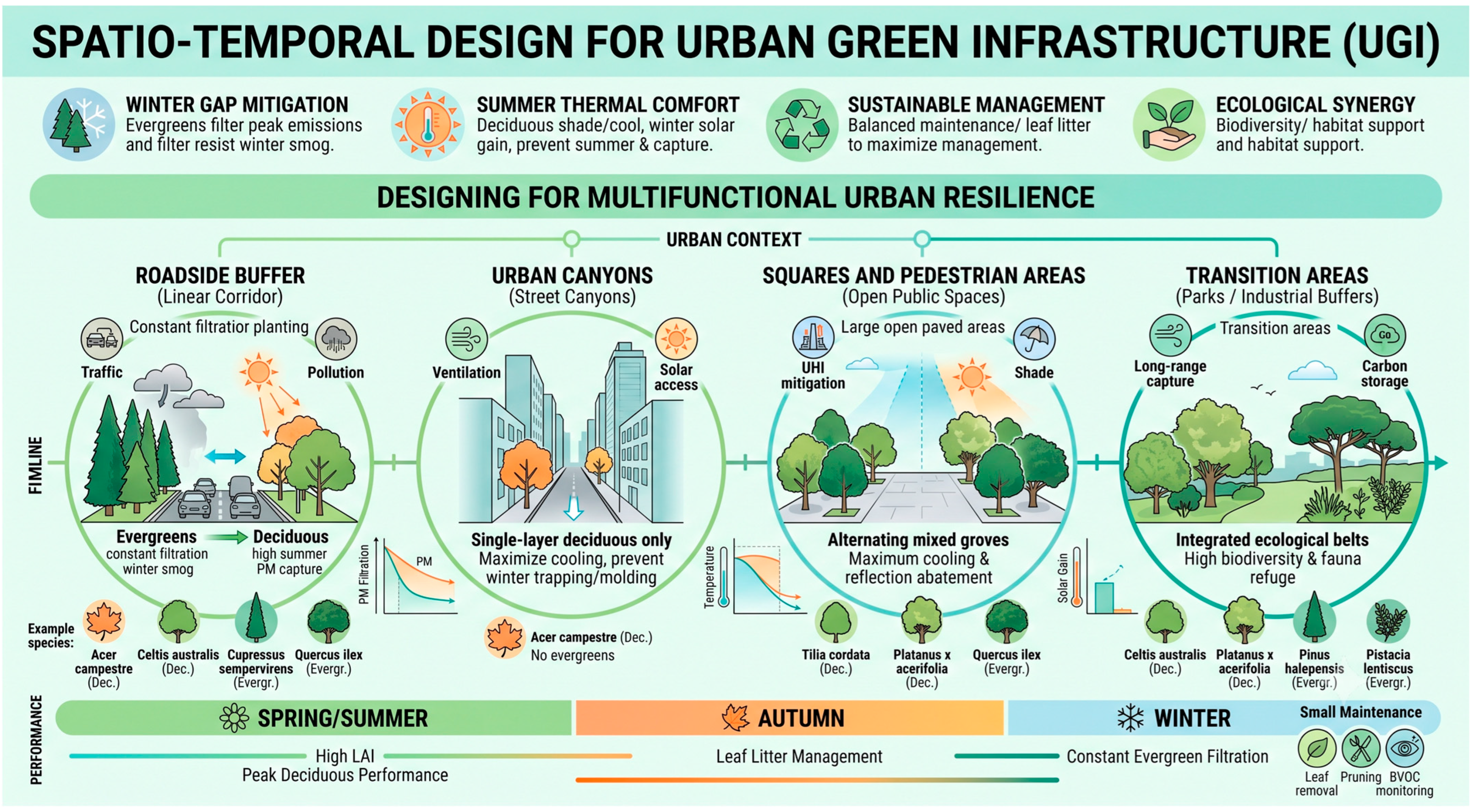
Based on existing evidence on vegetation–atmosphere interactions and urban planting strategies, the general design schema provides illustrative examples of context-specific vegetation configurations (Figure 2). These recommendations should be interpreted as literature-informed design guidance rather than as direct outcomes of the proposed analytical framework.
The integration of multi-source datasets enables the assessment of the relationships between vegetation phenology, urban morphology, pollutant dynamics, and ecosystem service provision. By considering seasonal variations in canopy development together with prevailing atmospheric conditions and urban spatial configuration, the framework supports the identification of vegetation strategies that maximize air pollution mitigation while preserving complementary ecosystem services, including thermal regulation, biodiversity enhancement, and urban climate resilience.
The role of the proposed framework is therefore not to prescribe a predefined planting solution for each urban typology, but to provide an analytical basis through which such literature-informed strategies can be evaluated and refined according to site-specific morphological, atmospheric, and environmental conditions. Thus, rather than promoting a single vegetation type, the framework could facilitate the selection of species assemblages capable of balancing the complementary functional roles of deciduous and evergreen trees [55]. In this perspective, the proposed approach contributes to a more performance-oriented design of urban forests, where species selection is driven by measurable ecosystem services instead of purely aesthetic or traditional landscaping criteria.
Overall, the proposed framework provides a structured methodology for evaluating the complementary roles and seasonal trade-offs of deciduous and evergreen vegetation, supporting the design of resilient Urban Green Infrastructure tailored to diverse environmental contexts.

3. Methodological Potential and Synthetic Demonstration

The proposed framework is expected to provide a comprehensive assessment of the complementary ecosystem services supplied by deciduous and evergreen vegetation across different urban environments.
Applying the integrated workflow typically yields multi-seasonal NDVI trajectories ranging from 0.65–0.85 in summer to <0.25 in winter for deciduous canopies, compared to stable year-round values (0.50–0.70) for evergreens. Supervised classification (RF/SVM) applied to multi-temporal Sentinel-2 stacks routinely achieves Overall Accuracies > 88% (Kappa > 0.82) in discriminating high/low deciduous and evergreen plant functional types (PFTs) against urban backgrounds [56,57]. In coupled dispersion simulations (e.g., ENVI-met), these classified layers translate into distinct mitigation dynamics: dense evergreen street buffers can sustain continuous winter PM2.5/PM10 concentration reductions of 12–25% during peak emission stagnation, whereas deciduous street canyons exhibit peak summer cooling (1.5–3.0 °C surface temperature reduction) while avoiding the severe winter pollutant entrapment and solar blockage associated with perennial evergreen barriers [58,59].

3.1. Spatio-Temporal Pollution Abatement and the Winter Gap

The atmospheric dispersion and dry deposition models reveal a stark contrast in pollution abatement dynamics across different seasons. During the summer months, the retrieved LAI for deciduous species peaks, demonstrating an exceptionally high capacity for particulate matter (PM2.5, PM10) and gaseous pollutant filtration. This high efficiency is further enhanced by the rapid biomass accumulation characteristic of deciduous trees.
However, during late autumn and winter, coinciding with the seasonal spike in anthropogenic emissions from domestic heating and unfavorable atmospheric inversion layers, the models highlight a critical “winter gap” in air quality mitigation for areas dominated by deciduous canopies [60]. Upon defoliation, the pollution trapping capacity of these species drops to near zero.
Conversely, evergreen species maintain a constant, uninterrupted filtering performance 365 days a year. Conifers (e.g., Pinus spp.), characterized by a complex needle-like structure and a waxy cuticle layer, exhibit high aerodynamic roughness, which significantly enhances the mechanical interception and immobilization of fine particulate matter during peak winter smog periods [61].

3.2. Microclimate Regulation and Building Energy Implications

GIS-coupled micro-meteorological simulations underscore opposing thermal and energy-saving behaviours between the two functional groups. In summer, deciduous species maximize evapotranspirative cooling and shading, blocking up to 80–90% of incident solar radiation [62,63,64].
This significantly mitigates the Urban Heat Island (UHI) effect and lowers building cooling loads [65,66,67]. Crucially, their winter defoliation allows for passive solar gain, permitting solar radiation to heat building facades and lowering winter heating demands.
On the other hand, while evergreen species offer steady perennial cooling, their permanent canopy poses challenges within deep, narrow street canyons (urban canyons). Micro-scale climate modeling indicates that dense evergreen configurations in restricted urban geometries obstruct winter wind ventilation and block critical solar access. This lack of sunlight maintains low ground temperatures and high winter humidity, occasionally promoting ice formation on sidewalks or biological molding on building envelopes [68].

3.3. Operational Trade-Offs: Maintenance, Biodiversity, and Secondary Pollutants

From an urban management and planning perspective, the results point to clear operational trade-offs, which are summarized below (Table 4).
While deciduous trees require high operational maintenance due to massive autumn leaf litter, which poses urban safety risks like slippery roads and clogged drainage systems [69], evergreens exhibit a lower, more distributed maintenance profile.
Furthermore, environmental costs must be accounted for: certain evergreen conifers act as high emitters of Biogenic Volatile Organic Compounds, such as monoterpenes. In highly polluted environments rich in anthropogenic NOx, these biogenic emissions can undergo photochemical reactions, leading to the formation of secondary organic aerosols (SOAs) and ground-level ozone (O3) [70], a factor that must be strictly monitored during species selection.
Finally, ecological mapping shows that while deciduous species foster high structural biodiversity by providing seasonal food and nesting habitats, evergreens offer indispensable winter micro-refuges for urban wildlife during harsh weather conditions.

3.4. Strengths and Limitations of the Proposed Framework

A defining characteristic of this work is its conceptual and methodological nature. While the four urban typologies illustrate the theoretical flexibility and adaptability of the workflow across diverse boundary conditions, this paper does not present empirical simulation runs or in-situ field sensor validation for each specific city. Fully deploying and calibrating the combined EO–GIS–CFD modeling chain across distinct urban domains represents a computationally demanding task that constitutes the logical subsequent phase of this research. The main strength of the proposed framework lies in the integration of complementary spatial, environmental, and functional information to support a context-sensitive assessment of urban vegetation. Rather than considering vegetation performance independently from its surrounding environment, the framework combines seasonal vegetation dynamics, urban morphology, atmospheric conditions, and the spatial distribution of potential emission sources. This integrated perspective can support the identification of vegetation configurations that are better aligned with specific environmental conditions and ecosystem service objectives.
At the same time, the proposed approach presents some operational limitations that should be considered in future applications. Its implementation depends on the availability and spatial resolution of EO, GIS, meteorological, and emission-related datasets, which may vary across urban contexts. In particular, the representation of heterogeneous urban environments and vegetation structure may be influenced by the resolution and quality of the available input data.
Additional uncertainties may arise from the modelling of microscale atmospheric processes, as local airflow and pollutant dispersion are influenced by complex interactions between urban geometry, vegetation structure, and changing meteorological conditions. Moreover, the integration of multiple datasets and modelling approaches may require significant computational resources depending on the spatial extent and level of detail of the analysis.
These limitations do not affect the conceptual objective of the framework but highlight the need to adapt its implementation to local data availability, computational capacity, and the specific objectives of each application. Future applications and case-study implementations will therefore be necessary to evaluate its performance under different urban and climatic conditions and to further refine the methodological workflow.

4. Conclusions

The multi-methodological evaluation of urban vegetation dynamics emphasizes that neither deciduous nor evergreen species can independently address the complex socio-environmental challenges of modern cities. Instead, the cornerstone of resilient urban forestry planning lies in strategic diversification.
By deploying a heterogeneous matrix of plant functional types, urban planners can successfully balance the seasonal thermal benefits and microclimate regulation offered by deciduous canopies with the perennial, uninterrupted air-filtering capacity of evergreen species. Importantly, the proposed framework does not consider species diversification as an objective in itself, nor does it assume that the same combination of vegetation types is equally effective in all urban environments. Rather, the selection and spatial configuration of plant species should be evaluated in relation to the specific conditions of the planting context, including urban morphology, proximity to emission sources, prevailing atmospheric conditions, and seasonal functional requirements. From this perspective, the proposed approach shifts the focus from the intrinsic characteristics of individual species towards their context-dependent performance and their interaction with the surrounding urban environment.
To maximize the cost–benefit ratio of UGI—minimizing maintenance costs (such as water consumption, safety risks from leaf litter, and infrastructure damage) while maximizing ecosystem services (pollution abatement, thermal comfort, and biodiversity support)—species selection must be tailored to specific climate regimes. Accordingly, the proposed framework is intended to support the selection of species not only based on their general ecological characteristics, but also according to their expected functional performance under specific urban and climatic conditions. As an illustrative application, a preliminary selection of species (Table 5) suitable for Mediterranean urban environments (characterized by hot, dry summers and mild, wet winters, yet prone to high summer ozone and winter particulate peaks) is proposed.
The proposed species assemblage illustrates how complementary functional characteristics can be combined to maximize year-round ecosystem service provision. By integrating deciduous species that provide seasonal cooling and winter solar access with evergreen species, ensuring continuous pollutant interception, urban planners can develop diversified and climate-adaptive UGI strategies tailored to local environmental conditions.
Ultimately, by transitionally shifting from monospecific green spaces to multi-layered, functional species assemblies, future urban design can move beyond simple aesthetic greening toward quantified, resilient environmental engineering. For example, in current climate change scenarios, this approach could be further developed by integrating dynamic climate suitability assessments into the species selection process. While this illustrative selection focuses on species suited to Mediterranean urban environments, future applications of the framework could explore a broader range of climate-adapted species and provenances where changing environmental conditions could progressively alter the performance of currently established urban vegetation. Such assessments should complement, rather than replace, the use of locally appropriate species and should carefully consider ecological compatibility and potential environmental risks.

Author Contributions

Conceptualization, V.M. and C.M.; methodology, V.M. and C.M.; software, V.M. and C.M.; validation, V.M. and C.M.; formal analysis, V.M. and C.M.; investigation, V.M. and C.M.; resources, V.M. and C.M.; data curation, V.M. and C.M.; writing—original draft preparation, V.M.; writing—review and editing, V.M. and C.M.; visualization, V.M. and C.M.; supervision, C.M.; project administration, C.M.; funding acquisition, C.M. All authors have read and agreed to the published version of the manuscript.

Funding

This research received no external funding.

Institutional Review Board Statement

Not applicable.

Informed Consent Statement

Not applicable.

Data Availability Statement

The original contributions presented in the study are included in the article; further inquiries can be directed to the corresponding author.

Acknowledgments

Authors used Gemini Pro v.3 to improve the quality of English.

Conflicts of Interest

The authors declare no conflicts of interest.

References

  1. Calvin, K.; Dasgupta, D.; Krinner, G.; Mukherji, A.; Thorne, P.W.; Trisos, C.; Romero, J.; Aldunce, P.; Barret, K.; Blanco, G.; et al. IPCC, 2023: Climate Change 2023: Synthesis Report, Summary for Policymakers. Contribution of Working Groups I, II and III to the Sixth Assessment Report of the Intergovernmental Panel on Climate Change [Core Writing Team, H. Lee and J. Romero (Eds.)]; Arias, P., Bustamante, M., Elgizouli, I., Flato, G., Howden, M., Méndez-Vallejo, C., Pereira, J.J., Pichs-Madruga, R., Rose, S.K., Saheb, Y., et al., Eds.; IPCC: Geneva, Switzerland, 2023. [Google Scholar]
  2. Zhang, X.; Han, L.; Wei, H.; Tan, X.; Zhou, W.; Li, W.; Qian, Y. Linking Urbanization and Air Quality Together: A Review and a Perspective on the Future Sustainable Urban Development. J. Clean. Prod. 2022, 346, 130988. [Google Scholar] [CrossRef] [Scilit]
  3. Babí Almenar, J.; Elliot, T.; Rugani, B.; Philippe, B.; Navarrete Gutierrez, T.; Sonnemann, G.; Geneletti, D. Nexus between Nature-Based Solutions, Ecosystem Services and Urban Challenges. Land Use Policy 2021, 100, 104898. [Google Scholar] [CrossRef] [Scilit]
  4. Chausson, A.; Turner, B.; Seddon, D.; Chabaneix, N.; Girardin, C.A.J.; Kapos, V.; Key, I.; Roe, D.; Smith, A.; Woroniecki, S.; et al. Mapping the Effectiveness of Nature-Based Solutions for Climate Change Adaptation. Glob. Change Biol. 2020, 26, 6134–6155. [Google Scholar] [CrossRef] [Scilit] [PubMed]
  5. Kumar, P.; Debele, S.E.; Sahani, J.; Rawat, N.; Marti-Cardona, B.; Alfieri, S.M.; Basu, B.; Basu, A.S.; Bowyer, P.; Charizopoulos, N.; et al. Nature-Based Solutions Efficiency Evaluation against Natural Hazards: Modelling Methods, Advantages and Limitations. Sci. Total Environ. 2021, 784, 147058. [Google Scholar] [CrossRef] [Scilit] [PubMed]
  6. Massarelli, C.; Campanale, C. Climatic, Bioclimatic, and Pedological Influences on the Vegetation Classification of “Bosco Dell’Incoronata” in Southern Italy. Rend. Lincei Sci. Fis. Nat. 2023, 34, 537–552. [Google Scholar] [CrossRef] [Scilit]
  7. Cohen-Shacham, E.; Walters, G.; Janzen, C.; Maginnis, S. Nature-Based Solutions to Address Global Societal Challenges; Cohen-Shacham, E., Walters, G., Janzen, C., Maginnis, S., Eds.; IUCN International Union for Conservation of Nature: Gland, Switzerland, 2016. [Google Scholar]
  8. Lozano, J.E.; Nainggolan, D.; Kofler, V.; Kernitzkyi, M.; Staccione, A.; Bidoli, C.; Mysiak, J.; Zandersen, M. Nature-Based Solutions: Typologies, Ecological Processes and Benefit Valuation Approaches across Landscapes. Nat.-Based Solut. 2025, 8, 100268. [Google Scholar] [CrossRef] [Scilit]
  9. Costadone, L.; Zhang, S. Integrated Valuation of the Ecological, Social and Economic Benefits Provided by a Multifunctional Nature-Based Solution. Nat.-Based Solut. 2025, 8, 100256. [Google Scholar] [CrossRef] [Scilit]
  10. Manzueta, R.; Kumar, P.; Ariño, A.H.; Martín-Gómez, C. Strategies to Reduce Air Pollution Emissions from Urban Residential Buildings. Sci. Total Environ. 2024, 951, 175809. [Google Scholar] [CrossRef] [Scilit] [PubMed]
  11. Sokolova, M.V.; Fath, B.D.; Grande, U.; Buonocore, E.; Franzese, P.P. The Role of Green Infrastructure in Providing Urban Ecosystem Services: Insights from a Bibliometric Perspective. Land 2024, 13, 1664. [Google Scholar] [CrossRef] [Scilit]
  12. Wu, Q.; Huang, Y.; Irga, P.; Kumar, P.; Li, W.; Wei, W.; Shon, H.K.; Lei, C.; Zhou, J.L. Synergistic Control of Urban Heat Island and Urban Pollution Island Effects Using Green Infrastructure. J. Environ. Manag. 2024, 370, 122985. [Google Scholar] [CrossRef] [Scilit] [PubMed]
  13. Andrew, H.; Sjöman, H. Tree Species Selection for Green Infrastructure: A Guide for Specifiers; Trees & Design Action Group: London, UK, 2019. [Google Scholar]
  14. Moura, B.B.; Zammarchi, F.; Manzini, J.; Yasutomo, H.; Brilli, L.; Vagnoli, C.; Gioli, B.; Zaldei, A.; Giordano, T.; Martinelli, F.; et al. Assessment of Seasonal Variations in Particulate Matter Accumulation and Elemental Composition in Urban Tree Species. Environ. Res. 2024, 252, 118782. [Google Scholar] [CrossRef] [Scilit] [PubMed]
  15. Liang, D.; Huang, G. Influence of Urban Tree Traits on Their Ecosystem Services: A Literature Review. Land 2023, 12, 1699. [Google Scholar] [CrossRef] [Scilit]
  16. Chen, X.; Li, Z.; Wang, Z.; Li, J.; Zhou, Y. The Impact of Different Types of Trees on Annual Thermal Comfort in Hot Summer and Cold Winter Areas. Forests 2024, 15, 1880. [Google Scholar] [CrossRef] [Scilit]
  17. Zhao, D.; Lei, Q.; Shi, Y.; Wang, M.; Chen, S.; Shah, K.; Ji, W. Role of Species and Planting Configuration on Transpiration and Microclimate for Urban Trees. Forests 2020, 11, 825. [Google Scholar] [CrossRef] [Scilit]
  18. Park, B.B.; Ko, Y.; Hernandez, J.O.; Byambadorj, S.O.; Han, S.H. Growth of Deciduous and Evergreen Species in Two Contrasting Temperate Forest Stands in Korea: An Intersite Experiment. Plants 2022, 11, 841. [Google Scholar] [CrossRef] [Scilit] [PubMed]
  19. Joshi, R.K.; Gupta, R.; Mishra, A.; Garkoti, S.C. Seasonal Variations of Leaf Ecophysiological Traits and Strategies of Co-Occurring Evergreen and Deciduous Trees in White Oak Forest in the Central Himalaya. Environ. Monit. Assess. 2024, 196, 634. [Google Scholar] [CrossRef] [Scilit] [PubMed]
  20. Ishida, A.; Yamaji, K.; Nakano, T.; Ladpala, P.; Popradit, A.; Yoshimura, K.; Saiki, S.T.; Maeda, T.; Yoshimura, J.; Koyama, K.; et al. Comparative Physiology of Canopy Tree Leaves in Evergreen and Deciduous Forests in Lowland Thailand. Sci. Data 2023, 10, 601. [Google Scholar] [CrossRef] [Scilit] [PubMed]
  21. Schwaab, J.; Meier, R.; Mussetti, G.; Seneviratne, S.; Bürgi, C.; Davin, E.L. The Role of Urban Trees in Reducing Land Surface Temperatures in European Cities. Nat. Commun. 2021, 12, 6763. [Google Scholar] [CrossRef] [Scilit] [PubMed]
  22. Calhoun, Z.D.; Willard, F.; Ge, C.; Rodriguez, C.; Bergin, M.; Carlson, D. Estimating the Effects of Vegetation and Increased Albedo on the Urban Heat Island Effect with Spatial Causal Inference. Sci. Rep. 2024, 14, 540. [Google Scholar] [CrossRef] [Scilit] [PubMed]
  23. Buraerah, M.F.; Patandjengi, B.; Suryani, S.; Hamzah, A.; Demmalino, E.B. The Effect of Vegetation in Reducing Air Pollution in an Urban Environment: A Review. In Proceedings of the IOP Conference Series: Earth and Environmental Science; Institute of Physics: Singapore, 2023; Volume 1253. [Google Scholar]
  24. Kabisch, N.; Frantzeskaki, N.; Hansen, R. Principles for Urban Nature-Based Solutions. Ambio 2022, 51, 1388–1401. [Google Scholar] [CrossRef] [Scilit] [PubMed]
  25. Kabisch, N.; Korn, H.; Stadler, J.; Bonn, A. Nature-Based Solutions to Climate Change Adaptation in Urban Areas—Linkages Between Science, Policy and Practice. In Theory and Practice of Urban Sustainability Transitions; Springer: Cham, Switzerland, 2017; pp. 1–11. [Google Scholar] [CrossRef] [Scilit]
  26. Mammone, V.; Massarelli, C. Evaluating the Effectiveness of Nature-Based Solutions: Tech-2 Nical, Economic, and Managerial Insights from Case Studies Comparisons. Appl. Sci. 2026, 16, 2686. [Google Scholar] [CrossRef] [Scilit]
  27. García-Pardo, K.A.; Moreno-Rangel, D.; Domínguez-Amarillo, S.; García-Chávez, J.R. Remote Sensing for the Assessment of Ecosystem Services Provided by Urban Vegetation: A Review of the Methods Applied. Urban For. Urban Green. 2022, 74, 127636. [Google Scholar] [CrossRef] [Scilit]
  28. Hu, M.; Li, X.; Xu, Y.; Huang, Z.; Chen, C.; Chen, J.; Du, H. Remote Sensing Monitoring of the Spatiotemporal Dynamics of Urban Forest Phenology and Its Response to Climate and Urbanization. Urban Clim. 2024, 53, 101810. [Google Scholar] [CrossRef] [Scilit]
  29. Sharma, G.; Morgenroth, J.; Richards, D.R.; Ye, N. Advancing Urban Forest and Ecosystem Service Assessment through the Integration of Remote Sensing and I-Tree Eco: A Systematic Review. Urban For. Urban Green. 2025, 104, 128659. [Google Scholar] [CrossRef] [Scilit]
  30. Xu, Y.; Xu, W.; Mo, L.; Heal, M.R.; Xu, X.; Yu, X. Quantifying Particulate Matter Accumulated on Leaves by 17 Species of Urban Trees in Beijing, China. Environ. Sci. Pollut. Res. 2018, 25, 12545–12556. [Google Scholar] [CrossRef] [Scilit] [PubMed]
  31. Neyns, R.; Canters, F. Mapping of Urban Vegetation with High-Resolution Remote Sensing: A Review. Remote Sens. 2022, 14, 1031. [Google Scholar] [CrossRef] [Scilit]
  32. Ernst, M.; Le Mentec, S.; Louvrier, M.; Loubet, B.; Personne, E.; Stella, P. Impact of Urban Greening on Microclimate and Air Quality in the Urban Canopy Layer: Identification of Knowledge Gaps and Challenges. Front. Environ. Sci. 2022, 10, 924742. [Google Scholar] [CrossRef] [Scilit]
  33. Singh, S.; Jain, K. Geospatial approach for urban environmental quality assessment. Int. Soc. Photogramm. Remote Sens. 2022, 43, 705–711. [Google Scholar] [CrossRef] [Scilit]
  34. Wu, X.; Liu, J.; Hou, Y. Data and Methods for Assessing Urban Green Infrastructure Using GIS: A Systematic Review. PLoS ONE 2025, 20, e0324906. [Google Scholar] [CrossRef] [Scilit] [PubMed]
  35. Ocón, J.; Stavros, E.; Steinberg, S.; Robertson, J.; Gillespie, T. Remote Sensing Approaches to Identify Trees to Species-Level in the Urban Forest: A Review. Prog. Phys. Geogr. Earth Environ. 2024, 48, 438–453. [Google Scholar] [CrossRef] [Scilit]
  36. Yel, S.G.; Özmen, H.B.; Öney Birol, S.; Tunç Görmüş, E.; Kaplan, G. Remote Sensing Applications for Assessing Climate Change Impacts on Deciduous Forests—A Systematic Review. Phys. Chem. Earth Parts A/B/C 2026, 143, 104321. [Google Scholar] [CrossRef] [Scilit]
  37. Binetti, M.S.; Uricchio, V.F.; Massarelli, C. Isolation Forest for Environmental Monitoring: A Data-Driven Approach to Land Management. Environments 2025, 12, 116. [Google Scholar] [CrossRef] [Scilit]
  38. Le Saint, T.; Nabucet, J.; Hubert-Moy, L.; Adeline, K. Estimation of Urban Tree Chlorophyll Content and Leaf Area Index Using Sentinel-2 Images and 3D Radiative Transfer Model Inversion. Remote Sens. 2024, 16, 3867. [Google Scholar] [CrossRef] [Scilit]
  39. Sebastiani, A.; Salvati, R.; Manes, F. Comparing Leaf Area Index Estimates in a Mediterranean Forest Using Field Measurements, Landsat 8, and Sentinel-2 Data. Ecol. Process. 2023, 12, 28. [Google Scholar] [CrossRef] [Scilit]
  40. Kumari, A.; Karthikeyan, S. Sentinel-2 Data for Land Use/Land Cover Mapping: A Meta-Analysis and Review. SN Comput. Sci. 2023, 4, 815. [Google Scholar] [CrossRef] [Scilit]
  41. Zhao, S.; Tu, K.; Ye, S.; Tang, H.; Hu, Y.; Xie, C. Land Use and Land Cover Classification Meets Deep Learning: A Review. Sensors 2023, 23, 8966. [Google Scholar] [CrossRef] [Scilit] [PubMed]
  42. Fellini, S.; Marro, M.; Del Ponte, A.V.; Barulli, M.; Soulhac, L.; Ridolfi, L.; Salizzoni, P. High Resolution Wind-Tunnel Investigation about the Effect of Street Trees on Pollutant Concentration and Street Canyon Ventilation. Build. Environ. 2022, 226, 109763. [Google Scholar] [CrossRef] [Scilit]
  43. Jato-Espino, D.; Manchado, C.; Roldán-Valcarce, A.; Moscardó, V. ArcUHI: A GIS Add-in for Automated Modelling of the Urban Heat Island Effect through Machine Learning. Urban Clim. 2022, 44, 101203. [Google Scholar] [CrossRef] [Scilit]
  44. Díaz-Borrego, J.; Escandón, R.; Alonso, A. Optimized Workflow for High-Resolution Urban Microclimate Modeling. Urban Sci. 2025, 9, 513. [Google Scholar] [CrossRef] [Scilit]
  45. Guerri, G.; Crisci, A.; Morabito, M. Urban Microclimate Simulations Based on GIS Data to Mitigate Thermal Hot-Spots: Tree Design Scenarios in an Industrial Area of Florence. Build. Environ. 2023, 245, 110854. [Google Scholar] [CrossRef] [Scilit]
  46. Massarelli, C. Developing a Calculation Workflow for Designing and Monitoring Urban Ecological Corridors: A Case Study. Urban Sci. 2024, 8, 169. [Google Scholar] [CrossRef] [Scilit]
  47. Cavazzin, B.; MacDonell, C.; Green, N.; Rothwell, J.J. Air Pollution Biomonitoring in an Urban-Industrial Setting (Taranto, Italy) Using Mediterranean Plant Species. Atmos. Pollut. Res. 2024, 15, 102105. [Google Scholar] [CrossRef] [Scilit]
  48. Mammone, V.; Binetti, M.S.; Massarelli, C. Digital Twin in Territorial Planning: Comparative Analysis for the Development of Adaptive Cities. Urban Sci. 2026, 10, 80. [Google Scholar] [CrossRef] [Scilit]
  49. Galán Díaz, J.; Gutiérrez-Bustillo, A.M.; Rojo, J. Influence of Urbanisation on the Phenology of Evergreen Coniferous and Deciduous Broadleaf Trees in Madrid (Spain). Landsc. Urban Plan. 2023, 235, 104760. [Google Scholar] [CrossRef] [Scilit]
  50. Schilirò, T.; Costa, S.; Marangon, D.; Bardi, L.; Pitasi, F.A.; Sacco, M.; Gea, M.; D’Amore, G.; Bernardi, M.; Fontana, M.; et al. Integrating Effect-Based Monitoring Tools into PM10 Assessment: Insights from an Air Quality Network in the Po Valley (Northern Italy), a Major European Air Pollution Hotspot. Environ. Res. 2026, 296, 124057. [Google Scholar] [CrossRef] [Scilit] [PubMed]
  51. Zhang, Y.; Yin, P.; Li, X.; Niu, Q.; Wang, Y.; Cao, W.; Huang, J.; Chen, H.; Yao, X.; Yu, L.; et al. The Divergent Response of Vegetation Phenology to Urbanization: A Case Study of Beijing City, China. Sci. Total Environ. 2022, 803, 150079. [Google Scholar] [CrossRef] [Scilit] [PubMed]
  52. Lieber, J.; Chen, X.; Chen, L.; Yang, J. Comparative Analysis of Microclimate Simulations: Assessing the Single-Layer Urban Canopy Model and ENVI-Met in Hong Kong. Urban Clim. 2025, 64, 102621. [Google Scholar] [CrossRef] [Scilit]
  53. Jing, L.; Liang, Y. The Impact of Tree Clusters on Air Circulation and Pollutant Diffusion-Urban Micro Scale Environmental Simulation Based on ENVI-Met. In Proceedings of the IOP Conference Series: Earth and Environmental Science; IOP Publishing Ltd.: Bristol, UK, 2021; Volume 657. [Google Scholar]
  54. Rezaali, M.; Fouladi-Fard, R.; O’Shaughnessy, P.; Naddafi, K.; Karimi, A. Assessment of AERMOD and ADMS for NOx Dispersion Modeling with a Combination of Line and Point Sources. Stoch. Environ. Res. Risk Assess. 2025, 39, 813–827. [Google Scholar] [CrossRef] [Scilit]
  55. Massarelli, C.; Binetti, M.S. Improving Urban Resilience Through a Scalable Multi-Criteria Planning Approach. Urban Sci. 2025, 9, 309. [Google Scholar] [CrossRef] [Scilit]
  56. Liu, P.; Ren, C.; Wang, Z.; Jia, M.; Yu, W.; Ren, H.; Xia, C. Evaluating the Potential of Sentinel-2 Time Series Imagery and Machine Learning for Tree Species Classification in a Mountainous Forest. Remote Sens. 2024, 16, 293. [Google Scholar] [CrossRef] [Scilit]
  57. Yao, Y.; Wang, X.; Qin, H.; Wang, W.; Zhou, W. Mapping Urban Tree Species by Integrating Canopy Height Model with Multi-Temporal Sentinel-2 Data. Remote Sens. 2025, 17, 790. [Google Scholar] [CrossRef] [Scilit]
  58. Buccolieri, R.; Gatto, E.; Manisco, M.; Ippolito, F.; Santiago, J.L.; Gao, Z. Characterization of Urban Greening in a District of Lecce (Southern Italy) for the Analysis of CO2 Storage and Air Pollutant Dispersion. Atmosphere 2020, 11, 967. [Google Scholar] [CrossRef] [Scilit]
  59. Gatto, E.; Ippolito, F.; Rispoli, G.; Carlo, O.S.; Santiago, J.L.; Aarrevaara, E.; Emmanuel, R.; Buccolieri, R. Analysis of Urban Greening Scenarios for Improving Outdoor Thermal Comfort in Neighbourhoods of Lecce (Southern Italy). Climate 2021, 9, 116. [Google Scholar] [CrossRef] [Scilit]
  60. Nersisyan, G.; Przybysz, A.; Vardanyan, Z.; Sayadyan, H.; Muradyan, N.; Grigoryan, M.; Ktrakyan, S. Peculiarities of Particulate Matter Absorption by Urban Tree Species in the Major Cities of Armenia. Sustainability 2024, 16, 217. [Google Scholar] [CrossRef] [Scilit]
  61. Diener, A.; Mudu, P. How Can Vegetation Protect Us from Air Pollution? A Critical Review on Green Spaces’ Mitigation Abilities for Air-Borne Particles from a Public Health Perspective—With Implications for Urban Planning. Sci. Total Environ. 2021, 796, 148605. [Google Scholar] [CrossRef] [Scilit] [PubMed]
  62. Susca, T.; Gaffin, S.R.; Dell’Osso, G.R. Positive Effects of Vegetation: Urban Heat Island and Green Roofs. Environ. Pollut. 2011, 159, 2119–2126. [Google Scholar] [CrossRef] [Scilit] [PubMed]
  63. Zardo, L.; Geneletti, D.; Pérez-Soba, M.; Van Eupen, M. Estimating the Cooling Capacity of Green Infrastructures to Support Urban Planning. Ecosyst. Serv. 2017, 26, 225–235. [Google Scholar] [CrossRef] [Scilit]
  64. Stache, E.E.; Schilperoort, B.B.; Ottelé, M.M.; Jonkers, H.M.H. Comparative Analysis in Thermal Behaviour of Common Urban Building Materials and Vegetation and Consequences for Urban Heat Island Effect. Build. Environ. 2022, 213, 108489. [Google Scholar] [CrossRef] [Scilit]
  65. Environmental Protection Agencys Office of Atmospheric Programs, U.S. Reducing Urban Heat Islands: Compendium of Strategies—Urban Heat Island Basics. Available online: https://www.epa.gov/heat-islands/heat-island-compendium (accessed on 6 September 2026).
  66. Soltanifard, H.; Amani-Beni, M. The Cooling Effect of Urban Green Spaces as Nature-Based Solutions for Mitigating Urban Heat: Insights from a Decade-Long Systematic Review. Clim. Risk Manag. 2025, 49, 100731. [Google Scholar] [CrossRef] [Scilit]
  67. Yu, H.; Zahidi, I.; Fai, C.M. Mitigating Urban Heat Islands (UHI) Through Vegetation Restoration: Insights From Mining Communities. Glob. Chall. 2025, 9, 2400288. [Google Scholar] [CrossRef] [Scilit] [PubMed]
  68. Nemitz, E.; Vieno, M.; Carnell, E.; Fitch, A.; Steadman, C.; Cryle, P.; Holland, M.; Morton, R.D.; Hall, J.; Mills, G.; et al. Potential and Limitation of Air Pollution Mitigation by Vegetation and Uncertainties of Deposition-Based Evaluations: Air Pollution Mitigation by Vegetation. Philos. Trans. R. Soc. A Math. Phys. Eng. Sci. 2020, 378, 20190320. [Google Scholar] [CrossRef] [Scilit] [PubMed]
  69. Kumar, K.; Kumar, B.; Krishna, S.B.N.; Patil, D.S. Leaf Litter Management in Urban Landscape Management: Recent Approaches. In Solid Waste Management: A Roadmap for Sustainable Environmental Practices and Circular Economy; Springer: Cham, Switzerland, 2025; pp. 45–61. [Google Scholar]
  70. Yang, Y.; Sun, F.; Hu, C.; Gao, J.; Wang, W.; Chen, Q.; Ye, J. Emissions of Biogenic Volatile Organic Compounds from Plants: Impacts of Air Pollutants and Environmental Variables. Curr. Pollut. Rep. 2025, 11, 10. [Google Scholar] [CrossRef] [Scilit]
  71. Khan, R.; Wheeler, P.; Gowing, D. Comparative Analysis of Diurnal Thermal Stress Responses and Lag Effects in Acer Campestre Using Chlorophyll Fluorescence During UK Summers 2022–2023. Earth Syst. Environ. 2026, 10, 7393–7408. [Google Scholar] [CrossRef] [Scilit] [PubMed]
  72. Porcu, F.; Fusaro, L.; Scartazza, A.; Traversari, S.; Pallozzi, E.; Stefanoni, W.; Di Palma, A.; Iozia, L.M.; Crescente, M.F.; Varone, L. Assessing Mediterranean Tree Species Suitability for Urban Environments: Insights from Experimental Data Including 23 Leaf Functional Traits. Plant Physiol. Biochem. 2025, 229, 110453. [Google Scholar] [CrossRef] [Scilit] [PubMed]
  73. Muscas, D.; Petrucci, R.; Orlandi, F.; Torre, L.; Fornaciari, M. Life Cycle Assessment of Common Urban Trees—The Environmental Performance of Three Mediterranean Cities. Sci. Total Environ. 2024, 954, 176690. [Google Scholar] [CrossRef] [Scilit] [PubMed]
  74. Sgrigna, G.; Baldacchini, C.; Dreveck, S.; Cheng, Z.; Calfapietra, C. Relationships between Air Particulate Matter Capture Efficiency and Leaf Traits in Twelve Tree Species from an Italian Urban-Industrial Environment. Sci. Total Environ. 2020, 718, 137310. [Google Scholar] [CrossRef] [Scilit] [PubMed]
  75. Abhijith, K.V.; Kumar, P.; Gallagher, J.; McNabola, A.; Baldauf, R.; Pilla, F.; Broderick, B.; Di Sabatino, S.; Pulvirenti, B. Air Pollution Abatement Performances of Green Infrastructure in Open Road and Built-up Street Canyon Environments—A Review. Atmos. Environ. 2017, 162, 71–86. [Google Scholar] [CrossRef] [Scilit]
  76. Tsaktsira, M.; Tsoulpha, P.; Economou, A.; Scaltsoyiannes, A. Mitigation of Global Climate Change through Genetic Improvement of Resin Production from Resinous Pines: The Case of Pinus Halepensis in Greece. Sustainability 2023, 15, 52. [Google Scholar] [CrossRef] [Scilit]
  77. Guarino, R.; Catalano, C.; Pasta, S. Beyond Urban Forests: The Multiple Functions and the Overlooked Role of Semi-Natural Ecosystems in Mediterranean Cities. Diversity 2024, 16, 447. [Google Scholar] [CrossRef] [Scilit]
  78. Esposito, F.; Memoli, V.; Panico, S.C.; Di Natale, G.; Trifuoggi, M.; Giarra, A.; Maisto, G. Leaf Traits of Quercus ilex L. Affect Particulate Matter Accumulation. Urban For. Urban Green. 2020, 54, 126780. [Google Scholar] [CrossRef] [Scilit]
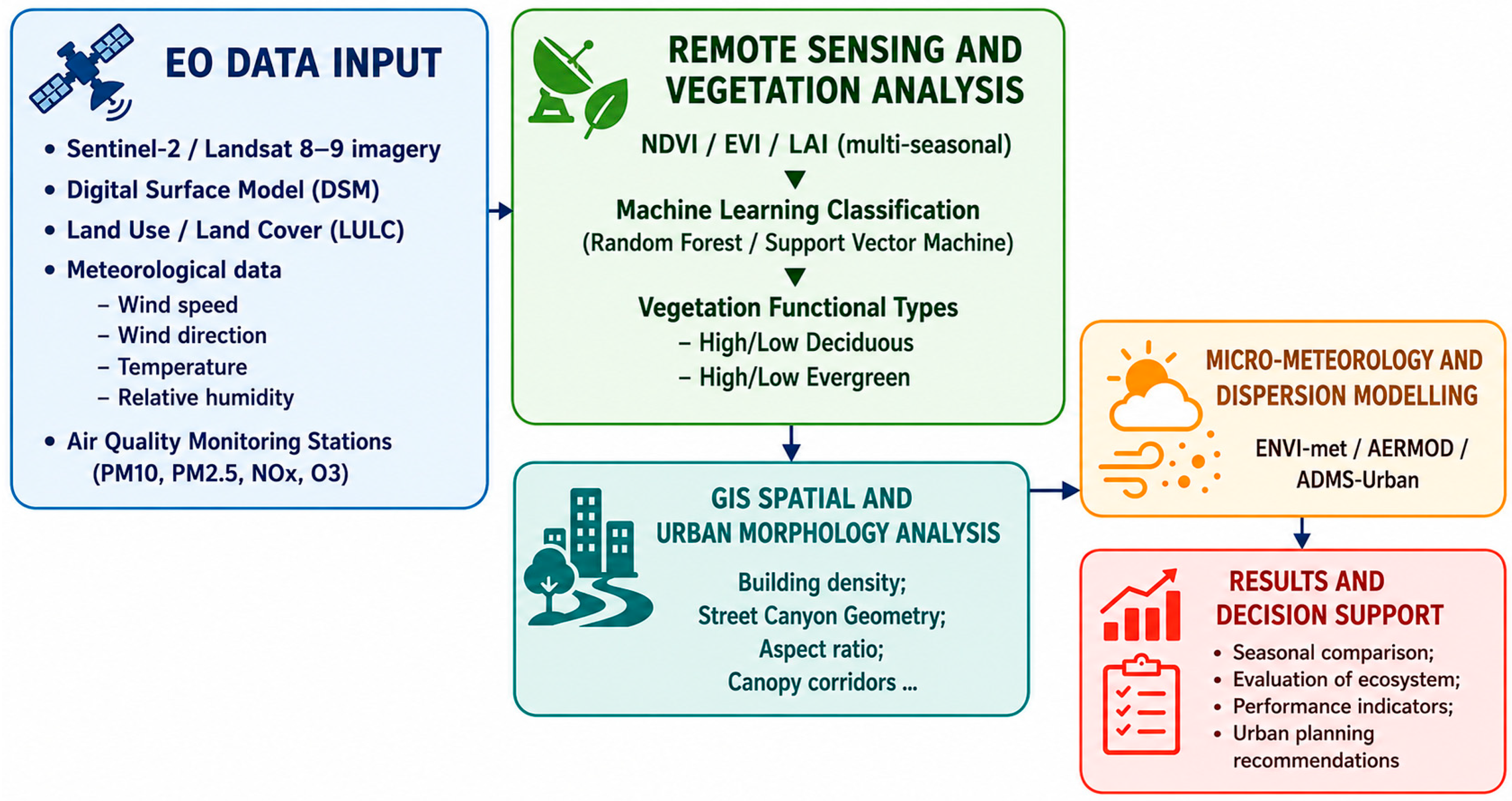
Figure 1. Conceptual workflow of the proposed methodological framework.
Urbansci 10 00533 g001
Figure 2. Conceptual illustration of literature-informed vegetation strategies for different urban contexts. The proposed planting configurations and example species are intended as illustrative design references and do not represent results directly generated or validated by the proposed analytical framework.
Urbansci 10 00533 g002
Table 1. Summary of input geospatial datasets, operational sources, spatial resolutions, and temporal specifications within the proposed framework.
Data CategoryTypical Data SourceSpatial
Resolution
Temporal
Frequency
Role in the
Framework
Multispectral EO DataSentinel-2 MSI (Level-2A BOA), Landsat-8/9 OLI (Level-2)10 m–20 m (Sentinel-2); 30 m (Landsat)Multi-seasonal (Spring flush, Summer maximum LAI, Autumn senescence, Winter dormancy)Direct calculation of spectral vegetation indices (NDVI, EVI, LAI) and machine-learning phenological classification
Elevation Models (DSM/DTM)Regional LiDAR Airborne Surveys, High-Resolution Photogrammetry, or Copernicus DEM1 m–5 m (LiDAR);
30 m (Copernicus DEM)
Static baseline (updated periodically)Extraction of building heights, vertical canopy profiles, street canyon aspect ratios, and aerodynamic roughness
Land Use/Land Cover (LULC)Copernicus Urban Atlas, Corine Land Cover (CLC), Local Municipal GIS layersVector (1:10,000) or Raster (10 m)Multi-annual baselineSpatial delimitation of urban fabric, green infrastructure, road networks, and proximity to emission sources
Meteorological & Air Quality DataGround monitoring networks (ARPA/EPA), WMO synoptic stations, ECMWF ERA5 reanalysisPoint measurements/0.1–0.25° gridHourly to seasonal aggregatesLocal wind fields, atmospheric boundary layer stability, and calibration/boundary conditions for dispersion models (ENVI-met, AERMOD)
Table 2. Representative urban typologies considered for the application of the proposed methodological framework.
Urban ContextClimateDominant Emission SourcesUrban MorphologyUGI ChallengeRefs.
Taranto (Southern Italy)Mediterranean coastalIndustry, port activities, road trafficCompact coastal city influenced by sea–land breeze circulationMitigation of industrial and traffic-related pollution[47,48]
Madrid (Spain)Mediterranean continentalRoad traffic, urban activitiesDense urban fabric with pronounced Urban Heat Island effectSeasonal vegetation dynamics and thermal regulation[49]
Po Valley (Northern Italy)Temperate basinAgriculture, industry, and road trafficRegional urban basin with frequent atmospheric stagnationPersistent winter accumulation of PM2.5 and PM10[50]
Beijing (China)Temperate monsoonIndustry, traffic, residential heatingHigh-density megacity affected by recurrent winter hazeAir pollution mitigation under extreme atmospheric conditions[51]
Table 3. Selection criteria, operational scales, and vegetation parameterization capabilities of the atmospheric dispersion models supported by the proposed framework.
ModelApproachSpatial Domain & ResolutionKey Vegetation Parameterization InputsApplication ScopeReferences
ENVI-met3D Non-hydrostatic CFD/Prognostic microclimateMicro-scale (<2 km2); Δx, Δy = 0.5–2 mSpatially explicit 3D LAD (Leaf Area Density), foliage aerodynamic drag coefficient, albedo, stomatal resistanceDeep street canyons, urban squares, localized buffer design, and microclimate thermal comfort evaluation.[52,53]
ADMS-UrbanQuasi-3D Gaussian/Boundary-layer turbulenceUrban/City scale (1–20 km; Δx = 10–50 mAerodynamic surface roughness length, canopy displacement height, street canyon porosity/aspect ratioHigh-density road transport corridors, multi-source urban network screening, and municipal-scale mitigation plans[54]
AERMODSteady-state Gaussian plume/PBL similarity theoryMeso/Regional scale (10–50 km); Δx = 50–500 mGrid-averaged surface roughness, surface albedo, Bowen ratioIndustrial buffer zones, broad peri-urban green belts, and regional air quality baseline assessment.[54]
Table 4. Comparison of key functional characteristics and ecosystem service trade-offs associated with deciduous and evergreen vegetation in urban environments.
Performance IndicatorDeciduous SpeciesEvergreen Species
Pollution FiltrationHigh in summer, minimal/absent in winterConstant year-round (critical for winter smog)
Thermal regulationMaximum summer cooling; allows winter solar gainConstant cooling may increase winter building heating loads
Maintenance requirementsHigh seasonal load (leaf litter management)Low, evenly distributed throughout the year
Growth dynamicsGenerally, rapid biomass accumulationGenerally slower development
Biodiversity supportSeasonal food sources (fruits/seeds) and habitatsPerennial winter shelter and protection for fauna
Table 5. Illustrative selection of Mediterranean urban tree species according to their expected ecosystem services and management characteristics within the proposed framework.
Botanical GroupSpeciesMain Ecosystem ServicesMain ConsiderationsReferences
DeciduousAcer campestreModerate canopy density, low BVOC emissions, good tolerance to pruning, and ozoneParticularly suitable for narrow streets and medium-density urban areas.[71]
Celtis australisExcellent summer shading, high drought tolerance, effective particulate matter interception, resilience to urban stressSuitable for streets and avenues exposed to traffic; low risk of branch failure due to flexible architecture.[72,73]
Platanus x acerifoliaHigh carbon sequestration capacity, rapid growth, and excellent particulate interceptionRequires careful management because of leaf litter and allergenic pollen; best suited for large urban spaces.[74]
Tilia cordataHigh evapotranspirative cooling, efficient PM capture, and significant Urban Heat Island mitigationRequires adequate soil volume and water availability under prolonged drought conditions.[73]
EvergreenCupressus sempervirensVertical filtering barrier, low spatial footprint, effective dust interceptionParticularly suitable for linear infrastructures and narrow urban corridors.[75]
Pinus halepensisPermanent aerodynamic barrier, tolerance to drought, and coastal environmentsHigh BVOC emissions should be considered in areas with elevated NOx concentrations.[76]
Pistacia lentiscusYear-round pollutant interception, high drought resistance, biodiversity support, and low maintenance requirementsParticularly suitable for roadside green barriers, buffer zones, and Mediterranean urban landscapes; highly tolerant of salinity and prolonged water stress.[77]
Quercus ilexContinuous PM2.5 and PM10 interception, year-round canopy, excellent drought resistanceOne of the most suitable species for Mediterranean urban environments and industrial areas.[78]
Disclaimer/Publisher’s Note: The statements, opinions and data contained in all publications are solely those of the individual author(s) and contributor(s) and not of MDPI and/or the editor(s). MDPI and/or the editor(s) disclaim responsibility for any injury to people or property resulting from any ideas, methods, instructions or products referred to in the content.