Article

River Corridors and River Engineering Works as Critical Infrastructure for Flood Resilience: Case Study of the Gradaščica River in Ljubljana, Slovenia


1
Faculty of Civil and Geodetic Engineering, University of Ljubljana & UNESCO Chair on Water-Related Disaster Risk Reduction, Jamova Cesta 2, 1000 Ljubljana, Slovenia
2
Department of Landscape, Water and Infrastructure, Institute of Mountain Risk Engineering, BOKU University, Peter-Jordan-Straße 82, 1190 Vienna, Austria
*
Author to whom correspondence should be addressed.
Infrastructures 2026, 11(9), 330; https://doi.org/10.3390/infrastructures11090330 (registering DOI)
Submission received: 23 July 2026 / Revised: 19 August 2026 / Accepted: 15 September 2026 / Published: 17 September 2026
(This article belongs to the Special Issue Nature-Based Solutions and Resilience of Infrastructure Systems)

Abstract

Climate and land-use change are increasing flood risk worldwide highlighting the need for more resilient and adaptive approaches to river management. While conventional flood-protection approaches rely primarily on grey infrastructure, Nature-based Solutions (NbSs) are gaining recognition for their ability to support more resilient and adaptive river systems. However, river corridors themselves are rarely considered and managed as critical infrastructure. This paper argues that river corridors should be recognised as critical infrastructure for flood resilience and demonstrates how a comprehensive monitoring framework can support their assessment and management. The monitoring framework is presented for the Gradaščica River restoration project in the City of Ljubljana, Slovenia, where a wide-range NbSs were implemented. A preliminary critical infrastructure condition assessment based on the RAMSSHEEP methodology was used to evaluate the river corridor under current and hazard-exposed conditions and to compare the contribution of grey, nature-based, and hybrid measures. The results indicate that NbSs and hybrid approaches provide the greatest overall improvement in the condition of the river corridor across the assessed performance indicators. Preliminary water-temperature measurements further suggest that restored riparian sections may help moderate additional downstream warming, although no direct cooling effect was observed. The study highlights the potential of treating river corridors as critical infrastructure and demonstrates how integrated monitoring can support more informed planning, management, and long-term resilience of river systems.

1. Introduction

In the past decade, the global hydrological cycle was heavily altered due to changes in climate and land cover. Extreme weather events are, amongst other, influencing the frequency and magnitude of fluvial (riverine) flooding, which are exacerbated by land use land cover changes [1,2,3,4]. Historically, flood protection heavily relied on grey infrastructure and river training measures, e.g., concrete embankments, channelised watercourses, retention dams. However, such structures have design-level structural vulnerabilities, as they are designed at a certain threshold design capacity. Once the threshold is exceeded, traditional flood-protection infrastructure can fail catastrophically [4,5]. Structural vulnerabilities arise when flood-protection infrastructure is exposed to water levels or hydraulic loads beyond its design capacity, that can result in overtopping, erosion, piping, or structural collapse of levees, embankments, or floodwalls. To transit towards systemic flood resilience rather than just traditional (grey) flood protection, Nature-based Solutions (NbSs) and hybrid (grey and green) infrastructure approaches are emerging [5,6]. As the performance of NbSs and hybrid approaches depends on site-specific environmental conditions and evolves over time, a comprehensive monitoring is needed to evaluate their long-term effectiveness, support adaptive management, and verify the delivery of expected environmental, social, and flood-risk reduction benefits. Nevertheless, monitoring is often insufficiently integrated into the planning, implementation, and management of NbSs, limiting the evidence base for assessing their performance and supporting their wider uptake [7,8,9]. NbSs and hybrid infrastructure approaches focus on slowing, storing, and filtering floodwaters within the river corridor, in contrast to fast channelling of water downstream. This is especially true for rivers flowing through cities, that have been historically regarded as hazards to be controlled or regulated rather than as ecological, social, and water-resource assets to be managed [10,11]. Beyond flood-risk reduction, NbSs and hybrid approaches can provide multiple co-benefits, including thermal regulation, biodiversity enhancement, water-quality improvement, carbon sequestration, and recreational opportunities. At the same time, they may involve trade-offs between different ecosystem functions and management objectives. For example, river restoration measures that increase channel width and reconnect floodplains may enhance flood resilience, while changes in channel geometry and shallower water depths can influence river thermal regimes and potentially increase water temperatures during warm periods. Therefore, monitoring should capture not only flood-resilience outcomes but also relevant co-benefits and trade-offs to support informed decision-making and adaptive management (e.g., [12]).
Recently, adaptive and flexible NbS elements (e.g., restored wetlands, riparian zones) have been recognised to help detain hydro-meteorological shocks [6,9,13]. In Europe, this technical shift is reflected in and supported by EU legislative framework. The EU Water Framework Directive, 2000/60/EC, mandates all member states to achieve good ecological status of their aquatic ecosystems (by protection and restoration) [14]. Furthermore, the EU Floods Directive 2007/60/EC [15] mandates the transition from local, small-scale flood protection towards larger-scale, basin-scale flood risk management and increasing of flood resilience. The Floods Directive explicitly promotes and encourages the synergies between risk management and ecological functionality by leveraging NbSs and hybrid approaches. Ultimately, the European Green Deal COM/2019/640 [16] and the EU Strategy on Adaptation to Climate Change COM (2021) 82 [14] act as the overarching umbrella bringing these directives under a common framework, placing NbSs and hybrid solutions as integral part of climate-adaptive infrastructure [16,17].
To turn these policies into actions, we must reconsider how to define and manage river systems. Traditional engineering practices limit the definition of infrastructure (and critical infrastructure) to man-made, grey structures. This traditional recognition of (critical) infrastructure ignores the foundational infrastructure that prevents flooding of the wider surrounding area of the river corridor. In a systemic flood resilience approach, if the primary flood protection structures (riverbanks, levees, floodplains, and riparian buffer zones) can withstand the flood-wave, the whole surrounding area, including all existing infrastructure in the area, is protected. Therefore, from the flood resilience point of view, it is imperative to reframe and recognise river systems, more specifically river corridors, including all their elements, not only as passive geographical features, but as active critical infrastructure [18,19].
This paper aims to demonstrate the concept for considering river corridors with its associated river engineering works as critical infrastructure for flood protection and flood resilience and demonstrate how a comprehensive monitoring framework can support their assessment, management, and resilience. This paper addresses the following objectives: (I) advocates the concept of river corridors as critical infrastructure for flood resilience, (II) presents a monitoring framework for evaluating their performance and resilience in a case study, (III) applies a preliminary assessment of critical infrastructure condition based on the RAMSSHEEP methodology [20,21], and (IV) investigates whether implemented measures yield co-benefits or trade-offs between flood protection and thermal regulation, according to preliminary short-term water temperatures measurements.

2. Flood Resilience and Critical Infrastructure Concepts

2.1. River Engineering Works as Critical Infrastructure

River engineering works for flood risk management, such as levees, dams, channelization, and bypasses, can be categorised as critical infrastructure (CI) to a very high extent, principally because they function as a “foundational layer” upon which other critical sectors (e.g., energy, transport, communication, water and wastewater) rely for operability. The extent of this categorisation is not uniform worldwide—it varies from explicit legal designation in some jurisdictions to functional reliance in others.
The United States of America is an example of high extent, they formally designate “Dams sector” as one of 16 critical infrastructure sectors (explicitly include levees, navigation locks, and flood control dams) [22,23]. These river works are treated in the USA with the same national security priority as nuclear power plants or the financial grid.
The European Union with its Critical Entities Resilience Directive [24,25] is an example of directive-based extent, where the directive classifies entities that provide essential services as critical entities. While flood protection is often managed by public bodies and it is not directly covered by the CER Directive, the operators of major river works are designated as critical entities because their failure would disrupt essential services across borders.
The UK is an example of a function-based approach, as they classify infrastructure according to its role in maintaining essential services (i.e., “criticality” to the network). Flood defences are often termed “essential infrastructure” in UK planning policy [26], while not always a standalone sector like energy, flood defences are afforded the highest protection levels because they are a prerequisite for the safety of other sectors.
River engineering works are critical to the extent that they constitute a single point of failure for multiple interconnected systems. Failure of a flood-protection structure may expose critical infrastructure and essential services to flooding, resulting in cascading disruptions across sectors. In the energy sector, power plants (nuclear and thermal) are frequently sited at a riverside for cooling. Floodwalls and intake structures are essential to prevent plant shutdown during high water events. In transport sector, bridges, rail embankments, and tunnels often rely on river channelisation (i.e., dredging or stabilisation) to prevent scour and inundation. A levee breach can endanger national or transnational transport arteries. In the water sector, drinking water intakes and wastewater treatment plants are typically at the lowest elevations in a catchment. Flood defences prevent the contamination of potable water supplies during floods. However, it is worth noting that river engineering works (river training) aimed exclusively at solving local flood problems, without considering impacts across the entire catchment, may result in negative effects. For example, channelizing rivers into narrow or concrete-lined channels can increase flow velocities and exacerbate flooding downstream.
When assessing which river works are critical, we may take the consequence-based approach developed for dams [27] that uses three consequence categories; (i) human impacts—quantified via total population at risk (i.e., flooding of a dense urban centre), (ii) economic impacts—including asset replacement value, remediation costs, and business interruption, and (iii) impacts on critical functions (i.e., cascading and systemic functional impacts on other sectors).
In Slovenia, as an EU member state, the EU Critical Entities Resilience Directive [24,25] was transferred into the national legislation [28]. After heavy floodings in Slovenia in August 2023 [29], a new flood regulation was adopted [30] that introduced the term of flood resilience for the first time in Slovenian legislation. A consequent step to increase flood resilience in Slovenia would be to recognise parts of the river engineering works built to increase flood safety as functional critical infrastructure. The case study of flood safety of the SW part of the City of Ljubljana, described in this paper, is a well-documented example of this approach to increase flood resilience in Slovenia using hybrid (grey and green) infrastructure as a solution.
The examples above are not intended to provide a quantitative comparison of flood-failure consequences across jurisdictions, but rather to illustrate different legislative and governance approaches to recognising river engineering works as critical infrastructure. Despite differences in regulatory frameworks, all examples acknowledge that the failure of key flood-protection assets can disrupt essential services and trigger cascading impacts across multiple sectors.

2.2. River Corridor as Critical Infrastructure

River corridors, which include the active water channel, the surrounding riparian vegetation, and the floodplain, are increasingly subjected to overlapping pressures from urbanisation, climate change, flood risk, ecological degradation, and land-use change [31]. Existing research shows that river corridors are increasingly recognised as resilience-building components of urban infrastructure that sustain ecosystem services and adaptive capacity [32]. Multiple sources now place river corridors within urban ecology planning and as essential components of infrastructure networks that help cities adapt to climate change while fostering biodiversity [33]. Current critical infrastructure frameworks, however, tend to focus on engineered water assets such as treatment, distribution, and drainage systems. In this context, the status of the river corridor itself as critical infrastructure remains underdeveloped in policy and planning. In this paper, therefore, we argue that river corridors should be conceptualised more explicitly as critical infrastructure. Also, we argue that this reframing could have direct advantages for how it is funded, monitored, maintained, managed, and protected in urban and regional planning.
River infrastructure, encompassing natural river systems, traditional river engineering elements, and integrated NbSs, serves as a primary component of critical infrastructure. Rivers are highly complex, multi-functional assets: they act as vital transport routes, generate hydropower, and provide essential water sources. However, if they are poorly managed, inadequately designed, or insufficiently regulated, they can pose severe risk. For this reason, the entire river infrastructure must be designed, operated, and maintained in a robust way that ensures its resilience to withstand heavy hydraulic loads during high-flow events, and to remain intact to protect the broader area. The recognition of river corridors as critical infrastructure has recently gained momentum, with numerous international organisations emphasising the urgency of this approach. It aligns with global disaster risk reduction strategies, such as the UN’s Sendai Framework [34], which explicitly categorises green and natural ecosystems as critical infrastructure. Furthermore, contemporary engineering literature increasingly recognises whole river corridors and river infrastructure as natural critical infrastructure or “super-infrastructure” that dictates the safety of the entire built environment [35,36].

3. Methodological and Monitoring Framework

3.1. Study Area

The study area includes river corridor where systematic flood protection works have been carried out, along the Gradaščica River—Mali graben within the City of Ljubljana, Slovenia. The study area is relatively highly urbanised. Mali graben (Gradaščica River) restoration was part of the wider national flood resilience project. The main objective of the Gradaščica River restoration project was hydraulic regulation with a focus on ensuring higher discharge (flow) capacity and stability of the watercourse. The Gradaščica River catchment is in central Slovenia and lies within the pre-alpine region. The river and its tributaries run through the Municipality of Dobrova-Polhov Gradec and the Municipality of the City of Ljubljana, where Gradaščica River drains into the karstic Ljubljanica River. The Gradaščica River springs in the hilly area of “Polhograjski dolomiti” to the west of the City of Ljubljana and has a total stream length of around 30 km with approximately 160 km2 catchment area [37]. The Gradaščica River has a torrential character river regime and drains a hilly terrain with highest peaks over 1000 m a.s.l. As the Gradaščica River enters the City of Ljubljana, it splits into two channels at the Bokalce weir, i.e., smaller “Mestna Gradaščica” (constructed urbanised channel) and larger “Mali graben” channel. Both, Mestna Gradaščica and Mali graben flow into the Ljubljanica River. Annual rainfall in the Gradaščica catchment ranges between 1600 and 1800 mm [38]. For the 1981–2010 period, the Bežigrad meteorological station in the City of Ljubljana recorded an average annual rainfall of approx. 1360 mm and mean air temperature of 10.9 °C with July peaking as the warmest month with average air temperature of 21.3 °C, followed by August and June [39].
This case study was selected because it provides a well-documented example of a flood-risk management project integrating hybrid measures (grey and NbSs). The south-western part of the City of Ljubljana is one of the most flood-prone areas in Slovenia due to its dense population and present damage potential. The combination of dense urbanisation and inadequate drainage and hydraulic conductivity of the pre-restoration channel of the Mali graben exacerbated the risk of flooding, causing high waters to inundate sub-urban and urban areas of the south-western and southern parts of Ljubljana. In the past, south-western part of the City of Ljubljana has been hit by severe flooding on several occasions. In the last 25 years, 10 significant floods have been recorded in the area, most recently in September 2010, October 2014 and again in August 2023 [29,40,41].
Although the specific hydraulic and institutional conditions are unique to Ljubljana, the case illustrates a broader conceptual perspective whereby river corridors and associated river-engineering works function as critical infrastructure due to their role in protecting interconnected systems and services. The findings are therefore intended to be analytically generalizable at the conceptual level rather than directly transferable as technical solutions.

3.2. River Restoration Works

To increase flood resilience and flood safety of the area, national flood resilience project was carried out. Overall, the river restoration works included reshaping of the river cross section, bank and bed stabilisation, and construction of protective infrastructure (levees, floodwalls, etc.). In the scope of the restoration works, a relief channel was built, as an additional safety measure to highly urbanised area. The relief channel serves as a by-pass to reduce pressure on the main channel during peak flows by diverting excess water towards the Ljubljana Marshes (Ljubljansko Barje) and later flows into the Ljubljanica River [42,43]. Within the study area, numerous NbSs were employed and incorporated into the river restoration works (Figure 1). The measures described in continuation are in line with NbS typology presented in Kuschel et al. [9] and NATURE-DEMO Catalogue of Suitable NbSs for Climate-Resilient Infrastructure [44], that were synthesised in the scope of the NATURE-DEMO Horizon Europe project [45].
The main measure implemented to improve hydraulic conveyance capacity during peak-flow conditions was channel reprofiling, primarily through channel widening. To maintain adequate ecological and hydraulic conditions during low-flow periods, the channel was designed as a two-stage channel system, consisting of a narrower inner channel that conveys normal and low flows, and a wider outer channel that is progressively inundated during high-flow events, thereby providing additional conveyance capacity while supporting ecological functions across a range of flow conditions.
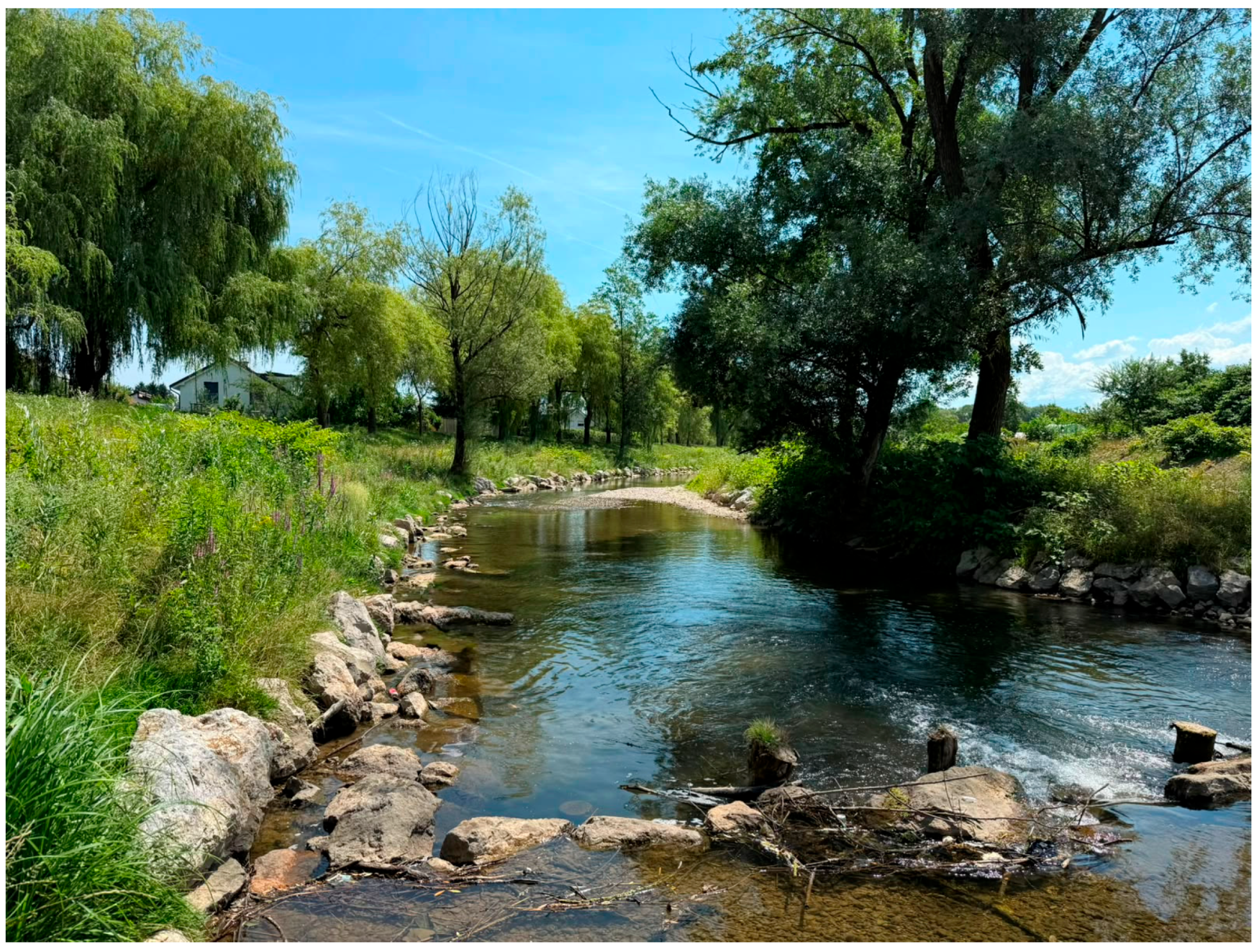
Due to high-urbanisation and urban confinement at some reaches, securing the channel conveyance by channel widening was not possible; therefore, traditional, grey measures had to be used. At those reaches, high-water flood protection walls were constructed. For additional safety against high-water flows, vegetated levees were established at some sections. River channel was stabilised by a combination of NbSs (vegetated riprap, live staking, root wad, vegetated crib wall, and rock sills) and traditional grey infrastructure used for river training (retaining walls, floodwalls). In the mid-section of the considered study area, a riparian buffer zone was established. Furthermore, along most of the river course, riverbanks, floodplains, and levees were additionally protected by establishing tree rows, bushes and shrubs in different spatial arrangements, depending on the local conditions (Figure 2). For the vegetation planting, only native species were used, such as willow, sedges, and alder. Riparian vegetation is mainly planted to stabilise banks, but it also provides shade to the watercourse, reducing water temperatures during summer.
In addition to the NbSs that contribute to hydraulic regulation, NbSs with a sole purpose of co-benefits provisioning were implemented along the study site to further enhance hydromorphological diversity and improve ecological condition of the river, especially by establishing habitats for diverse species. Examples of such NbSs include gravel bars, in-stream boulders, pools and still-water zones, and fish refugium.

3.3. Flood Risk and RAMSSHEEP-Based Resilience Assessment

In the study area, additional to the flood risk, associated risks are present. During high flows, water exerts higher stresses on riverbanks that lead to increased bank erosion, and ultimately can cause bank, levee, or embankment failure, which further contributes to the floods. Water-flow stresses on the bed of the channel can cause bed erosion, causing unsteady river (channel) bed. Both types of erosion contribute to turbidity of water in Gradaščica. Later, in the downstream reaches, the suspended sediment settles, causing sedimentation.
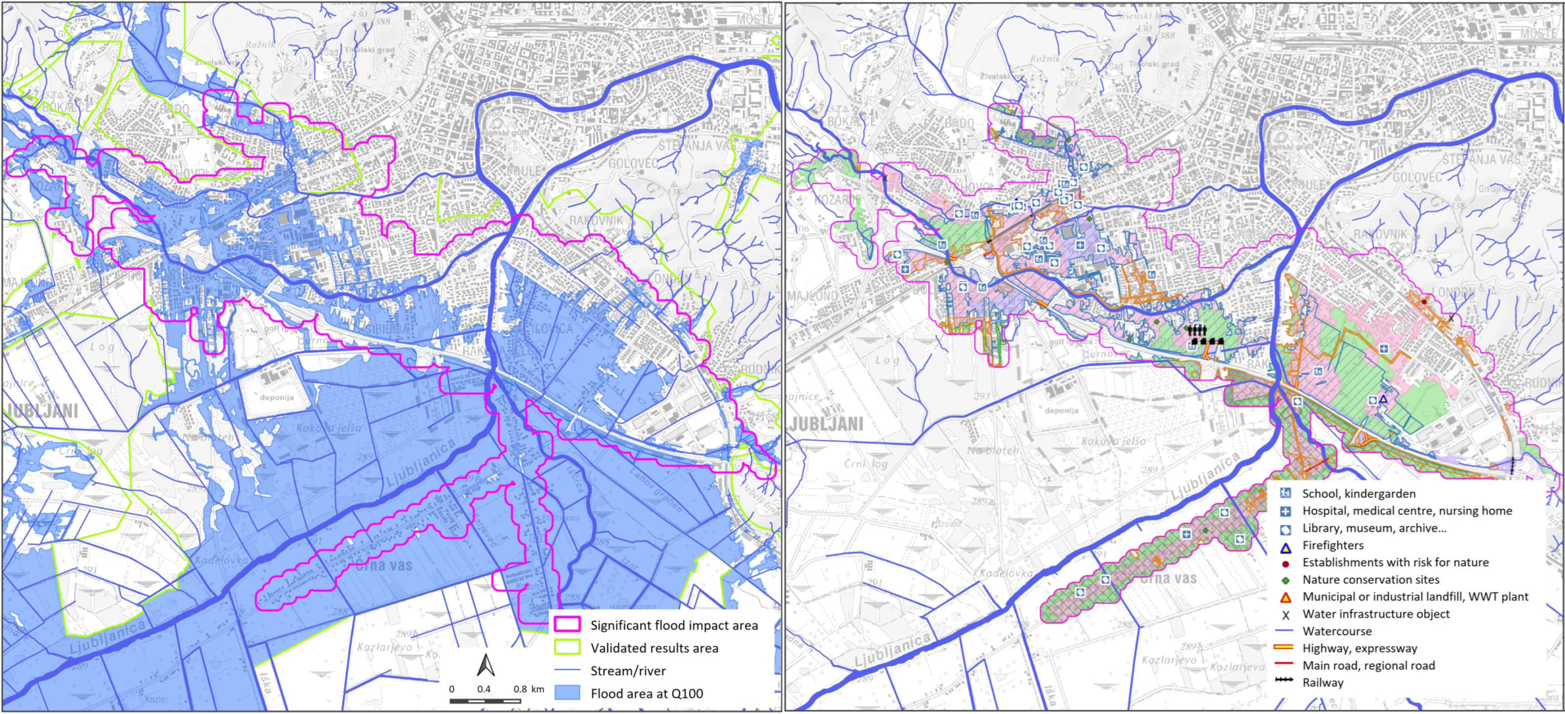
Whereas the whole area is at risk of flooding, some infrastructure elements of a strategic importance are also present in the area (Figure 3). Namely, a section of highway “Ljubljana ring road”, a part of the TEN-T core Mediterranean network and Baltic-Adriatic network [47], interconnecting (Maribor) Ljubljana-Koper (A1) highway and Karavanke-Zagreb (A2) highway. The main alternative to the mentioned highway section is Tržaška cesta (road Ljubljana-Vrhnika R409), which is also in the flood prone area. Other critical point-objects are also situated in the area, including volunteer firefighting headquarters Ljubljana-Vič, several elementary schools and kinder gardens, community health centres, nursing homes, and pharmacies [48,49]. Ultimately, as described, the river corridor itself constitutes the primary functional critical infrastructure. With the goal of providing systemic flood resilience, the Gradaščica–Mali graben corridor safeguards a wide array of other, above-mentioned, critical infrastructure.
To evaluate the performance of the river restoration measures on the river itself (as a critical infrastructure), an NbS-adapted RAMSSHEEP framework proposed by and detailly described in Fernandes et al. [20,21] was applied. This framework allows for a comprehensive evaluation of flood-resilience measures across different dimensions, accounting for infrastructure performance, natural hazards, and NbSs [20,21]. The framework assesses measures across multiple resilience dimensions, namely Reliability (R), Availability (A), Maintainability (M), Safety (S), Security (S), Health (H), Environment (E), Economics (E), and Politics (P), allowing a comprehensive assessment of infrastructure resilience when exposed to natural hazards. The assessment was carried out through an evaluation process. Five Key Performance Indicators (KPIs) are scored, according to expert judgement, available technical information, and local conditions. KPIs include Safety, Reliability and Security (SRS), Availability and Maintainability (AM), Economy (EC), Environment (EV), and Health and Politics (HP). The five KPIs were adopted from the NbS-adapted RAMSSHEEP framework [20,21] and represent aggregated resilience dimensions. Scores were assigned through comparative expert assessment based on available technical documentation, hydraulic studies, field observations, and local knowledge. The scoring scale ranges from 1 (very good) to 5 (very poor), reflecting the relative resilience performance of the river corridor under the considered hazard conditions. The resulting scores were visualised using spider-web diagrams. The scores range from 1 to 5, where 1 refers to very good and 5 to very poor (Appendix A).
In the assessment, the condition of observed river corridor (study area) is carried out for pre-restoration state, without measures (in RAMSSHEEP template called “current state”). This is followed by assessing the effect of natural hazard on infrastructure condition. The assessment considered the principal hazards affecting the Gradaščica-Mali graben river corridor, namely fluvial flooding and associated erosion and sedimentation processes. Hazard impacts were evaluated using available flood-risk studies, technical documentation, observations from past flood events, and expert knowledge of local river conditions. Then, the protective measures are added to the assessment, namely, grey protective infrastructure, NbSs, and combination of grey and NbSs (hybrid measures). In the present study, evaluated hybrid measures correspond to the measures implemented in the Gradaščica-Mali graben restoration project. Assessment of the grey-only and NbS-only scenarios assumes that the respective measures are implemented independently and exclusively, allowing the individual contributions of grey infrastructure and NbSs to flood resilience to be evaluated separately.
Finally, a comparation of measure approaches and their impact across observed dimensions is presented. In contrast to the full RAMSSHEEP procedure [20,21], the analysis was limited to the multi-criteria evaluation and graphical representation stage. The subsequent prioritisation and ranking steps were not performed, as the objective of this study was to illustrate the overall performance of the river restoration works, rather than to establish an implementation prioritisation of different measures approaches. The presented assessment represents a structured expert-based comparative evaluation and therefore includes uncertainties associated with subjective evaluation by experts. The results should be interpreted as descriptive indicators of the expected resilience of the evaluated options rather than precise quantitative measures. Future applications of the framework could be strengthened through stakeholder validation, multi-expert scoring, and sensitivity or uncertainty analyses.

3.4. Monitoring Framework

Considering river corridors as critical infrastructure, leads to a need for systematic monitoring. River’s condition and capacity to store, convey, and attenuate water directly influences its role in flood resilience of the safeguarded area. Strategically established monitoring provides information on the performance but also gives information about the condition and potential degradation of the river corridor. Since NbSs are favoured in contrast to grey infrastructure mainly due to the ecosystem services and co-benefits they provide, monitoring should extend beyond risk-associated parameters to the measurable co-benefit parameters. On the other hand, NbSs might entail trade-offs in some respects, depending on the site-specific conditions; what is considered a benefit in one setting may be a trade-off in another.
With the purpose of evaluating and assessing the area of river restoration in Gradaščica-Mali graben, within the scope of the NATURE-DEMO project [45], a complex monitoring system is planned for the study area. The establishment of monitoring is focused on capturing physical and measurable parameters relevant to the flow characteristics, while also capturing additional ecosystem services (co-benefits) provided. Regarding the later, in this paper, we provide the first insight into water temperature measurements at the study area, and the evaluation if the water-temperature behaviour can be considered as an additional ecosystem service (co-benefit) or, on the other hand, as a trade-off due to channel profile modifications, resulting in an increased river-water surface area along certain river reaches.
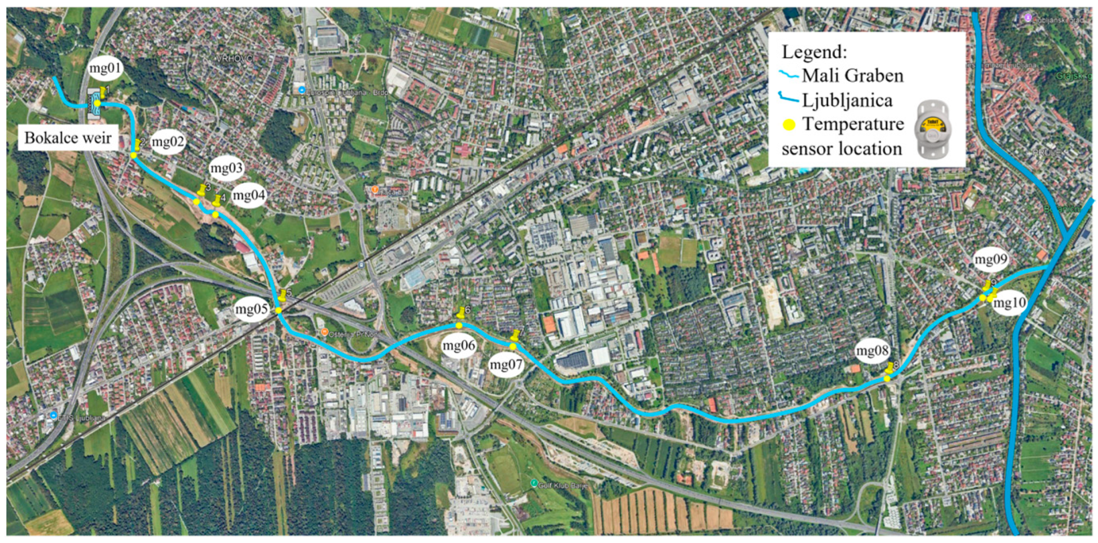
The main monitoring efforts at the study site will focus on hydraulic monitoring, including water levels and establishing the relation with discharge of the Mali graben. For this purpose, the installation of pressure sensors is planned for the continuous monitoring of water levels in the channel, and determination of the new rating curve. It should be noted that establishing a precise and reliable rating curve is a gradual process, as it requires field flow measurements captured across a wide range of hydrological and discharge conditions. Therefore, the flow calculation results are not presented at this stage. The focus of geomorphological monitoring is on capturing and evaluating major changes in riverbanks; mainly related to erosion hotspots and eroded sediment volumes using an unmanned aerial vehicle (UAV–LiDAR). LiDAR is also the primary method for determining the establishment and preservation of vegetation as part of the ecological monitoring of the demonstration area. In addition to riparian vegetation dynamics, ecological monitoring will include assessing water quality (using a multi-parameter probe) and thermal conditions in the water and the immediate vicinity of the study area. Temperatures of the water and surroundings are determined using UAV-based thermal imaging and button-type temperature sensors installed in June 2026 at multiple locations along the investigated river corridor (Figure 4). From geomorphological aspect, also localised changes in the riverbed and suspended sediment transport dynamics and properties will be investigated. Later will be monitored continuously using multi-parameter probe and occasionally on point water samples.
Urban rivers and waterways are increasingly acknowledged as vital parts of a city’s natural and climate infrastructure, delivering a range of hydrological, ecological, and social benefits, from flood mitigation, thermal regulation to recreational opportunities [50]. Hence, restoring and revitalising urban rivers/streams can create blue-green corridors that cool cities and mitigate heat islands, but the magnitude depends on the size, width, shape, and network form of the river and the surrounding land use and imperviousness [51]. However, these benefits are being undermined by a counteracting trend: rivers are warming due to climate change, with this effect amplified by compounded pressures from land use change and water usage, thus affecting aquatic ecosystems [52]. McBean et al. [53] pointed out that water temperature is a key variable as it determines habitat suitability for flora and fauna and mediates physical, chemical, and biological processes.
The water temperature in Mali graben is monitored using HOBO TidbiT MX Temperature 400-ft Data Logger MX2203 sensors installed at multiple locations along the study reach (Figure 4). The upstream sensor (mg01) was installed in the headwater of the Bokalce weir, while the remaining sensors were distributed downstream (mg02–mg09) to capture the longitudinal thermal pattern along the stream. Sensors were installed approximately 10–15 cm above the riverbed. Air temperature was also monitored using the same sensor type at the downstream section of the reach close to mg09, installed at the bridge pier (Figure 4). Temperature data is logged at 10 min intervals.
The present analysis considered the period from 10 June 2026, to 7 July 2026, to examine the stream temperature patterns during a continuous summer observation window and assess the response of Mali graben to sustained warm conditions, including the heatwave event observed during the study period [54]. All analyses and visualisations were performed in R version 4.4.3 [55]. Given that the present dataset covers only one month of monitoring, the results should be considered preliminary and interpreted primarily as an initial assessment of stream thermal patterns rather than as a robust quantification of the thermal regulation co-benefits of riparian vegetation. Longer-term monitoring across multiple seasons and years, encompassing a wider range of hydrological and meteorological conditions, is planned to strengthen the assessment of the thermal ecosystem services provided by the riparian corridor.

4. Results and Discussion

4.1. RAMSSHEEP-Based Resilience Assessment

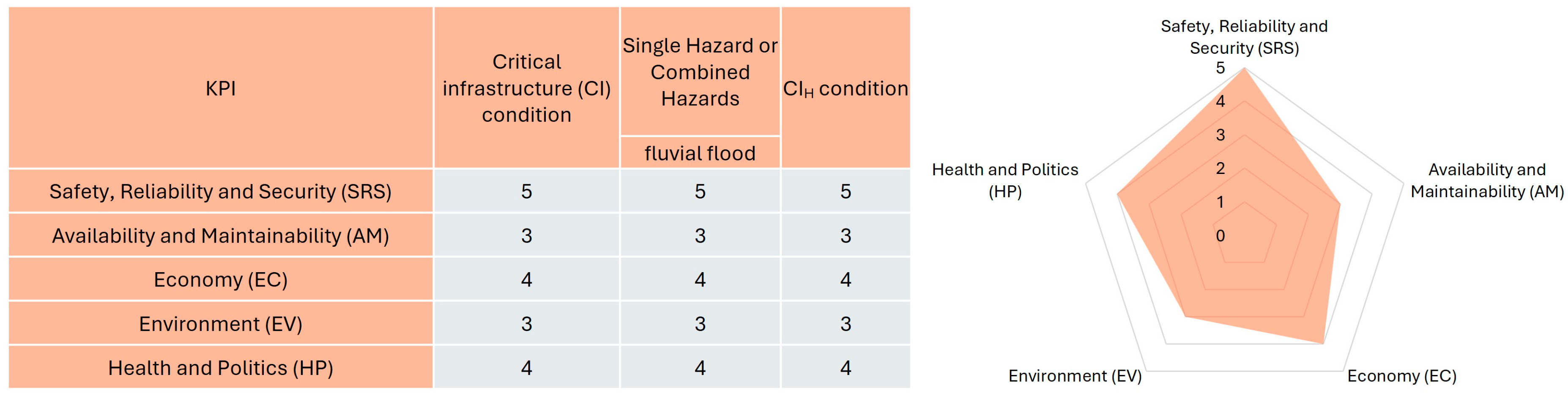
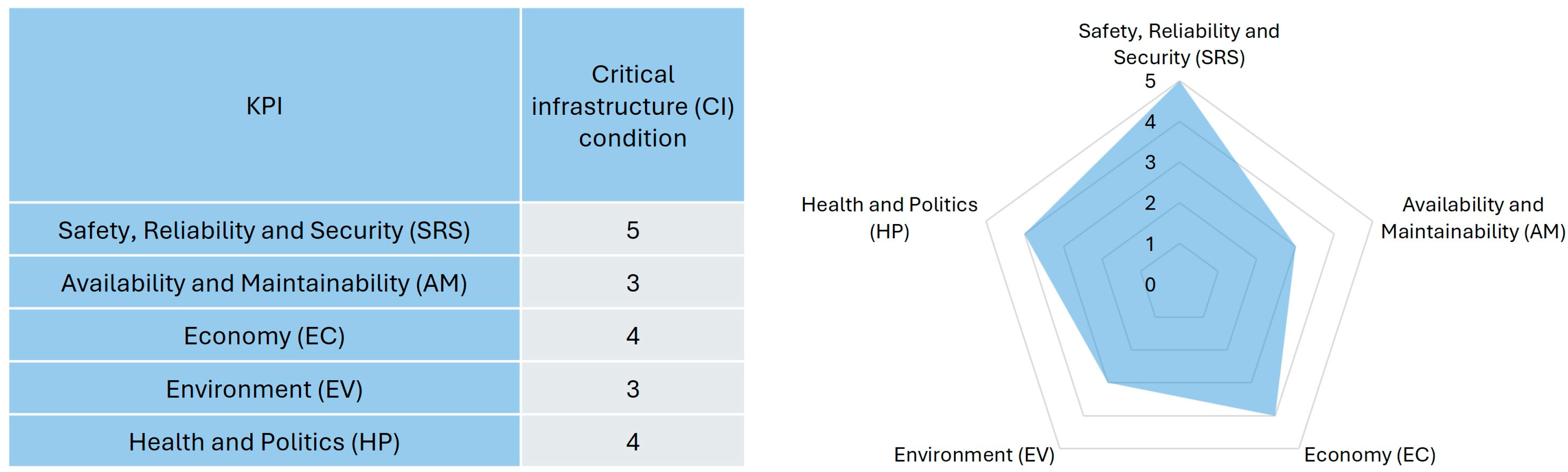
The assessed “current” condition of the critical infrastructure (river corridor), before any restoration measures were implemented (CI), is shown in Figure 5. Score 1 refers to very good condition, while 5 to very poor. The condition of the river corridor was relatively poor, resulting in frequent flooding (as described in “Study area”), which reflects in the scores assigned. For Safety, Reliability, and Security (SRS) it was scored with 5, due to insufficient hydraulic conveyance. The estimated insufficiency was for one-third lower than designed. This was only exacerbated by changes in hydrometeorological conditions (e.g., intensity and frequency of heavy rainfall and high flows), overgrowth of the riparian vegetation, and siltation. For Economy (EC) and Health and Politics (HP) score 4 was assigned. The reasons for this were high direct and indirect costs after flooding, and public perception of the frequent floods in SW part of Ljubljana affecting the pressure on the policymakers. Score fair (3) was assigned to Availability and Maintainability (AM) and Environment (EV). The reason for both mainly lies in the need for increased maintenance works after flooding. However, although negatively affecting the hydraulic conveyance, overgrowth of vegetation provided ecosystem services, mainly habitat creation.
In the next step, the assessment, according to RAMSSHEEP methodology [20,21], focuses on the impact of selected climate-related hazards on the critical infrastructure—river corridor. For each KPI, an estimation is given of the condition of the pre-restoration river corridor after exposure to given hazards (CIH) (Figure 6). Essentially, the scoring of the infrastructure condition when exposed to hazards is the same as the “current condition”, due to the frequent flooding of the area.
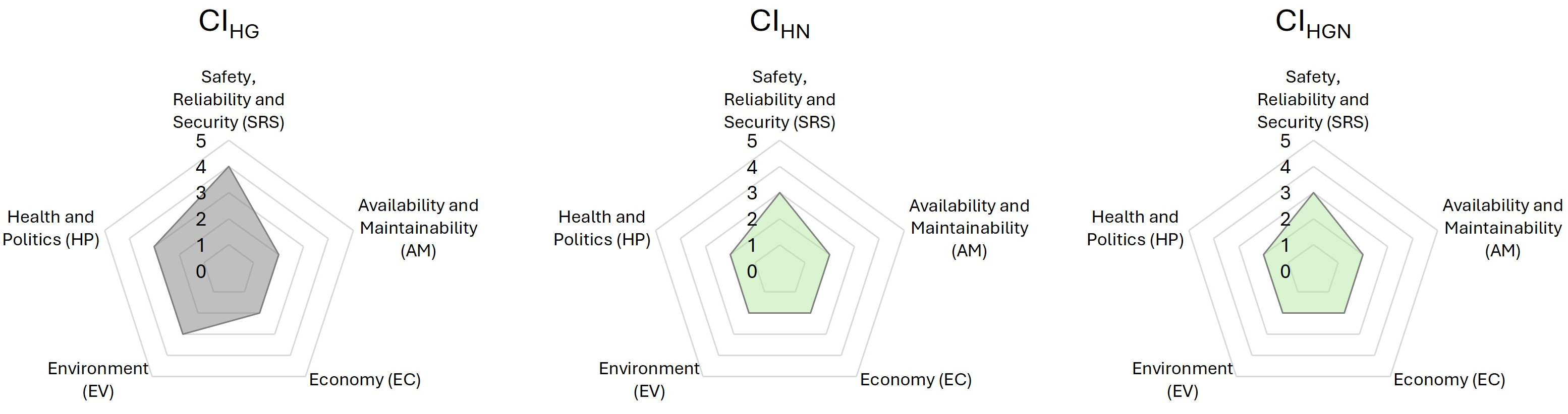
After the assessment of the hazard impact, evaluation of the effect (benefits) of different protective measure approaches (grey, NbSs, and combination) is carried out. The measures considered in this stage of assessment were those implemented in the Gradaščica–Mali graben river restoration project. Evaluation of the effect of grey infrastructure on critical infrastructure (CIHG) (Figure 7 left), showed noticeable improvements of the CI conditions across all KPIs, apart from Environment (EV) that stays the same (3). SRS, AM, and HP improved for one score, while EC increased for two scores (to “Good”, 2). These results underscore the positive impact of traditional, grey protective in mitigating flood-related degradation and highlight their relevance in climate adaptation planning for (linear) river engineering infrastructure systems. However, evaluation of the NbS effect on CI condition (CIHN) identified higher improvement in KPI scores (Figure 7 middle). More specifically, SRS KPI improved for two scores (“Fair”, 3), while all the other KPIs were assigned with score 2 (“good”). Finally, an assessment of the hybrid solution, a combination of GPI and NbSs (CIHGN) is presented (Figure 7 right). This solution corresponds to the measures implemented in the study area. It is evident that the results are identical as for CIHN. This is because in the observed section of the river, i.e., in the study area, the main measure to secure hydraulic conveyance was channel widening (NbSs), while additional grey measures targeted protecting housing and more critical urban areas. However, the assessment was carried out only for the river corridor that was regarded as critical infrastructure; therefore, the external infrastructure was not assessed. Thus, it should be noted that without GPI in a given specific local condition, an SRS grade better than 3 is hardly reachable. This is especially true because of urban confinement, which requires traditional measures for bank protection and channel stabilisation.

4.2. Water Temperature as an Indicator of Ecosystem Services

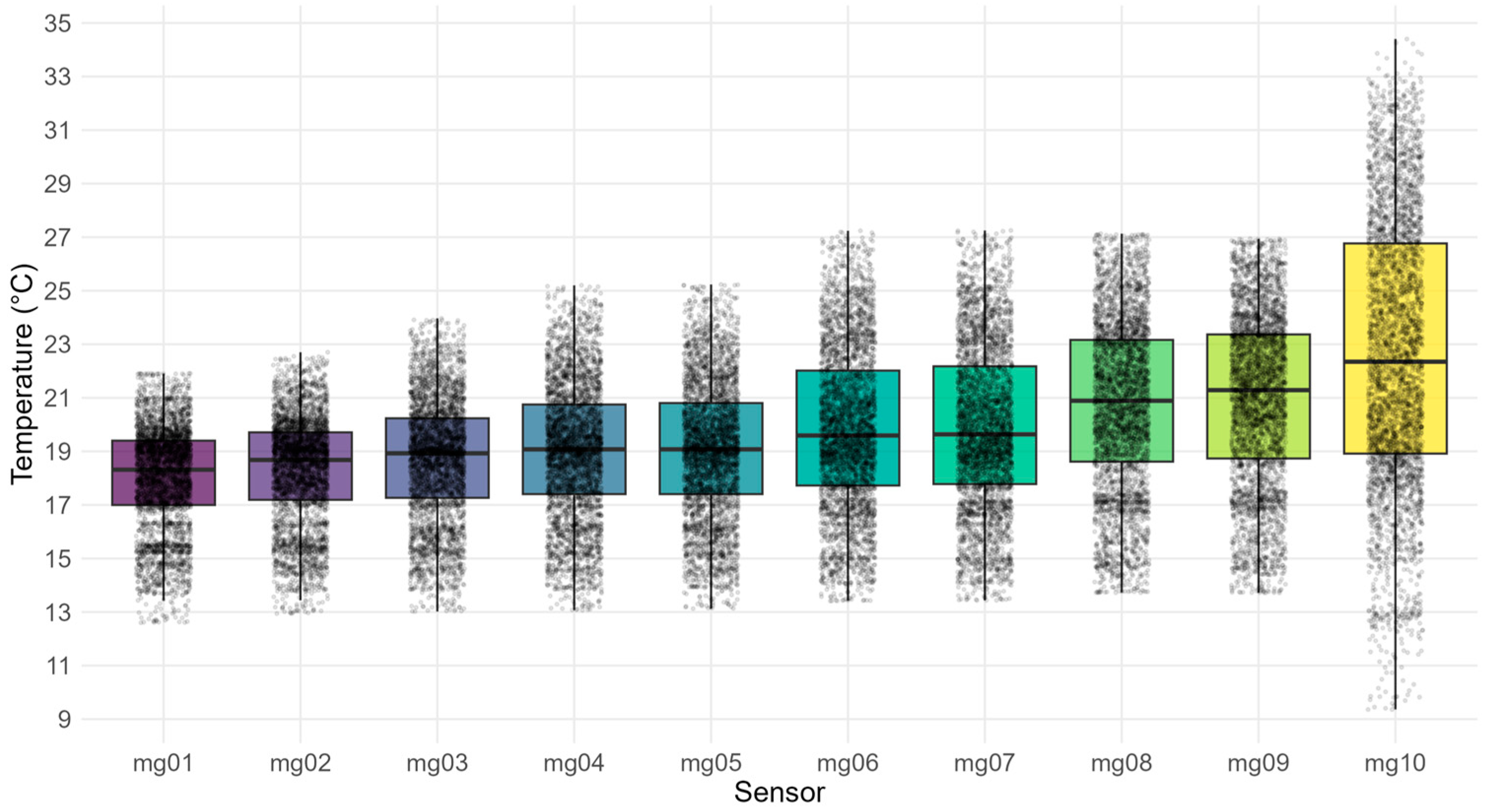
The temperature measurements from Mali graben (Figure 8 and Figure 9) reveal how ecological concerns are expressed in an urban stream during a period of strong summer warming. Water temperature shows a clear downstream warming pattern where temperatures (Table 1) are generally lower (18 °C) at the upstream of Bokalce weir (mg01) and become progressively warmer toward downstream locations at mg08–mg09, up to 21 °C. The boxplots (Figure 8) suggest that this longitudinal warming occurs in a stepwise manner rather than a smooth gradient, as mg01–mg05 form a relatively cooler cluster, mg06 and mg07 form a warmer and more variable cluster, and mg08–mg09 form the warmest group. The lower temperature at mg01 reflects the upstream backwater conditions created by the weir, which drives hyporheic exchange (the movement of surface water through the streambed sediments) and increases water depth [56,57]. On the other hand, the reach, where mg06 and mg07 sensors were installed, has the most NbSs implemented during the restoration works, specifically in terms of the introduction of vegetation, yet are warmer than the less-vegetated reaches upstream (like mg03 and mg05). It is counterintuitive, but as explained by Durfee et al. [58], Garner et al. [59], and Trimmel et al. [60], vegetation does not cool the river directly, only by blocking the solar radiation; therefore, its effect depends on whether the canopy actually shades the wetted channel (or where the sensor was installed) at the time of peak heating. Riparian buffers (as implemented around mg06 and mg07) primarily reduce incoming solar radiation and limit further warming of the water, rather than actively cooling it [59,60]. The warming gradient between mg05 and mg07 showed to be smaller than for the whole reach, which could suggest that the riparian buffer is attenuating additional warming, even though the absolute temperature is higher. This is consistent with previous studies of Seyedhashemi et al. [61], that found reduced rates of stream temperature increase in areas with riparian vegetation. Additionally, shade effectiveness varies with tree height, canopy density, shading geometry, bank position, stream orientation, and width, and can be weak if vegetation is present but poorly aligned to cast effective shade, which is especially true at the early maturity of NbS vegetation [62].
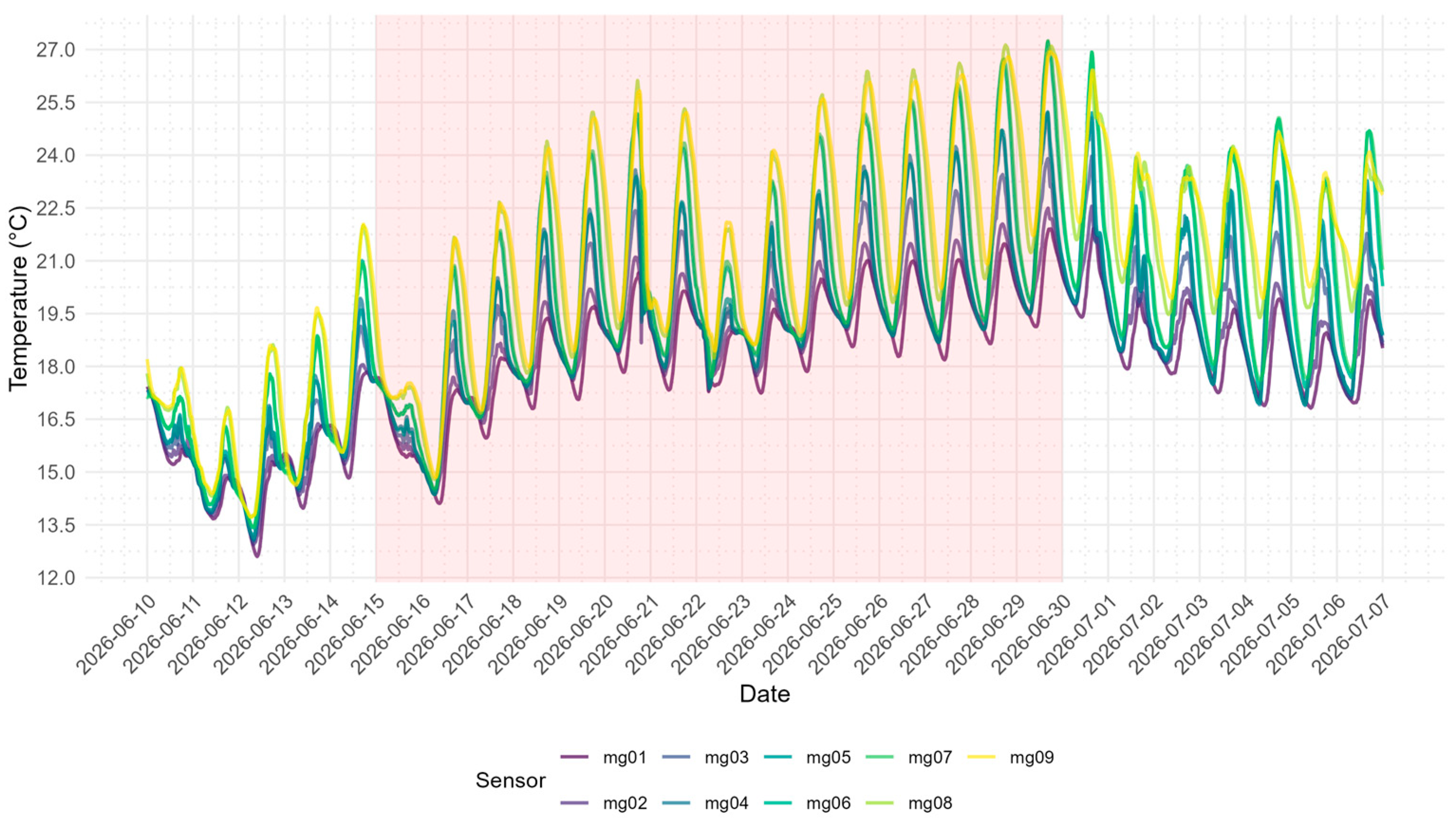
Figure 9 shows the same spatial ordering repeated on a nearly every date across the roughly four-week record, with a distinct temporal warming trend during the sustained warm spell in the second half of June. It also shows that the upstream sections remain relatively cooler than the downstream reach even during the heatwave (marked with red shading). Furthermore, it adds the diel component where downstream sites show higher daytime maxima, indicating that both the mean water temperature and day-to-day amplitude of the thermal signal increase along the reach. This observation is consistent with previous studies (e.g., [63,64,65,66]), which reported downstream warming of stream temperature along the flow path, where cumulative heat exchange with the atmosphere, longer residence time, and reduced thermal buffering can cause progressively warmer conditions. As water flows downstream, it accumulates heat input, so temperature often rises with distance [63,64]. Longitudinal warming is stronger where water has more time to absorb solar heat energy, so longer residence time promotes downstream temperature increase. Sections with slower velocity allow water to remain longer in a reach, which enhances heat accumulation and raises maximum temperature [59]. Hence, widening a channel for a similar discharge during low flows mechanically reduces average depth and velocity. Both changes increase the sensitivity of the reach to atmospheric heating, where a shallower column has less thermal mass to absorb before its temperature rises for a given net heat input. Even with the presence of vegetation, reaches can have higher mean or minimum temperatures if shading reduces daytime heating but also limits night-time heat loss [60]. The study of Fuller et al. [67] found that streams with bankfull widths under 10 m exhibit higher cooling rates and greater responsiveness to riparian shade restoration than wider channels.
Based on the preliminary, one-month temperature monitoring data, no clear cooling effect of the implemented NbS can be concluded. Nevertheless, the attenuated warming trend within the riparian buffer reach suggests that vegetation may contribute to limiting further water temperature increases as the water flows downstream, highlighting the potential for thermal co-benefits. However, further, long-term investigation of thermal regulating functioning is required.

5. Conclusions

This paper argues for a reconceptualization of river corridors in river management by reframing them as active critical infrastructure rather than only passive geomorphological features on landscape. By recognising the entire river corridor, including its active channel, riparian vegetation, and floodplains, as a functional critical infrastructure, planners can better ensure the flood resilience of the broader area. The application of the RAMSSHEEP methodology to the Gradaščica–Mali graben restoration project in Ljubljana demonstrates the practical advantages of such an approach. The assessment reveals that while traditional grey flood measures improve safety and economic indicators, Nature-based Solutions (NbSs) and hybrid approaches provide the most systematic improvements across all key performance indicators of river engineering works for flood safety and resilience. Specifically, the study shows that NbS elements like channel widening and riparian buffers not only enhance hydraulic conveyance but also restore ecological functionality that grey infrastructure usually neglects. Furthermore, the implementation of an integrated monitoring framework is essential for managing river corridors as critical assets. Preliminary water temperature data from the study site in Slovenia highlight the complexity of managing co-benefits, such as thermal regulation to mitigate the negative effects of heat islands in urban areas. While initial water temperature measurements did not show a direct cooling effect from newly implemented NbSs, the attenuated warming trend observed within riparian buffer reaches suggests that it may reduce the warming of the river water downstream. This underscores the need for long-term monitoring to fully capture the performance, co-benefits, and potential trade-offs of NbSs. Ultimately, recognising river corridors as functional critical infrastructure can support more informed decision-making throughout planning, implementation, and maintenance phases. This conceptual transition, supported by comprehensive monitoring, is vital for achieving systemic flood resilience.

Author Contributions

Conceptualisation, T.K., M.M. and E.K.; methodology, T.K., M.B.A., K.L., M.M. and E.K.; formal analysis, M.B.A.; data curation, T.K. and M.B.A.; writing—original draft preparation, T.K., M.B.A., K.L. and M.M.; writing—review and editing, T.K., M.B.A., K.L., M.M. and E.K.; visualisation, M.B.A., T.K., M.M. and E.K.; funding acquisition, M.M. All authors have read and agreed to the published version of the manuscript.

Funding

NATURE-DEMO (“Nature-Based Solutions for Demonstrating Climate-Resilient Critical Infrastructure”; https://www.nature-demo.eu/) is an innovation action funded under the European Union’s Horizon Europe Programme, Grant Agreement No. 101157448. The project is further co-funded by the Slovenian Research and Innovation Agency, core programme No. P2-0180.

Data Availability Statement

The original contributions presented in this study are included in the article. Further inquiries can be directed to the corresponding author.

Conflicts of Interest

The authors declare no conflicts of interest.

Abbreviations

The following abbreviations are used in this manuscript:
NATURE-DEMONature-based Solutions for Demonstrating Climate-Resilient Critical Infrastructure
DRSVSlovenian Water Agency (orig. Direkcija Republike Slovenije za vode)
KPIKey Performance Indicator
RAMSSHEEPReliability, Availability, Maintainability, Safety, Security, Health, Environment, Economics, Politics

Appendix A

Table A1. Key performance indicators of RAMSSHEEP methodology.
AbbreviationDescription
SRSSafety, Reliability and Security
AMAvailability and Maintainability
ECEconomy
EVEnvironment
HPHealth and Politics
Table A2. Rating scale for evaluation of key performance indicators of RAMSSHEEP methodology.
ScoreInterpretation
1Very good performance, high resilience
2Good performance, minor deficiencies
3Fair, moderate performance
4Poor performance, significant deficiencies
5Very poor performance, high vulnerability

References

  1. Blöschl, G.; Hall, J.; Viglione, A.; Perdigão, R.A.P.; Parajka, J.; Merz, B.; Lun, D.; Arheimer, B.; Bilat, M.; van Beethoven, O.; et al. Changing climate both increases and decreases European river floods. Nature 2019, 573, 108–111. [Google Scholar] [CrossRef] [Scilit] [PubMed]
  2. Intergovernmental Panel on Climate Change (IPCC). Water Cycle Changes. In Climate Change 2021: The Physical Science Basis; Douville, H., Raghavan, K., Renwick, J., Allan, R.P., Arias, P.A., Barlow, M., Cerezo-Mota, R., Cherchi, A., Gan, T.Y., Gergis, J., et al., Eds.; Contribution of Working Group I to the Sixth Assessment Report of the Intergovernmental Panel on Climate Change; Cambridge University Press: Cambridge, UK, 2021; pp. 1055–1210. [Google Scholar] [CrossRef] [Scilit]
  3. Intergovernmental Panel on Climate Change (IPCC). Weather and Climate Extreme Events in a Changing Climate. In Climate Change 2021: The Physical Science Basis; Seneviratne, S.I., Zhang, X., Adnan, M., Badi, W., Dereczynski, C., Di Luca, A., Ghosh, S., Iskandar, I., Kossin, J., Lewis, S., et al., Eds.; Contribution of Working Group I to the Sixth Assessment Report of the Intergovernmental Panel on Climate Change; Cambridge University Press: Cambridge, UK, 2021; pp. 1513–1766. [Google Scholar] [CrossRef] [Scilit]
  4. Zhang, W.; Lin, P.; Ding, M.; Ross, M.W.; Song, C.; He, B.; Lu, H.; Gao, S.; Yamazaki, D.; Wood, E.F.; et al. Reversal of the levee effect towards sustainable floodplain management. Nat. Sustain. 2023, 6, 1578–1586. [Google Scholar] [CrossRef] [Scilit]
  5. Kundzewicz, Z.W.; Licznar, P. Climate change adjustments in engineering design standards: European perspective. Water Policy 2021, 23, 85–105. [Google Scholar] [CrossRef] [Scilit]
  6. Knox, R.L.; Wohl, E.E.; Morrison, R.R. Levees don’t protect, they disconnect: A critical review of how artificial levees impact floodplain functions. Sci. Total Environ. 2022, 837, 155773. [Google Scholar] [CrossRef] [Scilit] [PubMed]
  7. IUCN. Global Standard for Nature-Based Solutions, 1st ed.; A User-Friendly Framework for the Verification, Design and Scaling Up of NbS; Tech. Rep.; IUCN: Gland, Switzerland, 2020; 21p, Available online: https://portals.iucn.org/library/sites/library/files/documents/2020-020-En.pdf (accessed on 11 August 2026).
  8. UNaLab. Nature-Based Solutions Implementation Handbook; Tech. Rep.; Deliverable 5.5; Urban Nature Labs Project: Tampere, Finland, 2022; 366p, Available online: https://unalab.eu/system/files/2024-01/d55-nbs-implementation-handbook2024-01-04.pdf (accessed on 15 July 2026).
  9. Kuschel, E.; Obriejetan, M.; Kuzmanić, T.; Mikoš, M.; Seifert, L.; Conevski, S.; Wirth, M.; Canga, E.; Fernandes, S.; Hübl, J.; et al. A Systematic Framework for Assessing the Temporally Variable Protective Capacity of Nature-Based Solutions Against Natural Hazards. Infrastructures 2025, 10, 318. [Google Scholar] [CrossRef] [Scilit]
  10. Bell, S. Water and the city: Risk, resilience and planning for a sustainable future: By Iain White, Abingdon, Routledge, 220 pp., 2010, ISBN 0-203-84831-4. Int. J. Urban Sustain. Dev. 2011, 3, 134–136. [Google Scholar] [CrossRef] [Scilit]
  11. Faccin, A.; Voltolina, A.; Carrer, G.M.; Dalla Bona, R.; Smania, D.; Palmeri, L.; Barausse, A. Integrated environmental monitoring in the canals of Padova (Italy) shows the need for trade-off solutions in water resources management in complex historical cities. J. Environ. Manag. 2026, 401, 128784. [Google Scholar] [CrossRef] [Scilit] [PubMed]
  12. Barker, M.I.; Burnett, J.D.; Arismendi, I.; Wing, M.G. Assessing Heterogeneity of Surface Water Temperature Following Stream Restoration and a High-Intensity Fire from Thermal Imagery. Remote Sens. 2025, 17, 1254. [Google Scholar] [CrossRef] [Scilit]
  13. Ansari, A.H.; Mejia, A.; Cibin, R. Flood teleconnections from levees undermine disaster resilience. npj Nat. Hazards 2024, 1, 2. [Google Scholar] [CrossRef] [Scilit]
  14. European Parliament; Council of the European Union. Directive 2000/60/EC of the European Parliament and of the Council of 23 October 2000 establishing a framework for Community action in the field of water policy. Off. J. Eur. Communities 2000, L 327, 1–73. [Google Scholar]
  15. European Parliament; Council of the European Union. Directive 2007/60/EC of the European Parliament and of the Council of 23 October 2007 on the assessment and management of flood risks. Off. J. Eur. Union 2007, L 288, 27–34. [Google Scholar]
  16. European Commission. The European Green Deal; COM(2019) 640 Final; European Commission: Brussels, Belgium, 2019. [Google Scholar]
  17. European Commission. Forging a Climate-Resilient Europe—The New EU Strategy on Adaptation to Climate Change; COM(2021) 82 Final; European Commission: Brussels, Belgium, 2021. [Google Scholar]
  18. United Nations Office for Disaster Risk Reduction (UNDRR). Critical Infrastructure; Sendai Framework Terminology on Disaster Risk Reduction; UNDRR: Geneva, Switzerland, 2017; Available online: https://www.undrr.org/terminology/critical-infrastructure (accessed on 1 July 2026).
  19. Fekete, A. Critical infrastructure and flood resilience: Cascading effects beyond water. WIREs Water 2020, 7, e1370. [Google Scholar] [CrossRef] [Scilit]
  20. PPD 21. Critical Infrastructure Security and Resilience. Presidential Policy Directive 21; The White House: Washington, DC, USA, 2013. Available online: https://obamawhitehouse.archives.gov/the-press-office/2013/02/12/presidential-policy-directive-critical-infrastructure-security-and-resil (accessed on 14 July 2026).
  21. Administration of Joseph R. Biden, Jr. National Security Memorandum on Critical Infrastructure Security and Resilience; NSM-22; The White House: Washington, DC, USA, 2024; 22p. Available online: https://www.govinfo.gov/content/pkg/DCPD-202400358/pdf/DCPD-202400358.pdf (accessed on 15 July 2026).
  22. CER. Directive (EU) 2022/2557 of the European Parliament and of the Council of 14 December 2022 on the resilience of critical entities and repealing Council Directive 2008/114/EC. Off. J. Eur. Union 2022, L 333, 164–198. [Google Scholar]
  23. CER. Critical Entities Resilience Directive (CER)—Updates, Compliance. Available online: https://www.critical-entities-resilience-directive.com/ (accessed on 12 July 2026).
  24. NPPF. National Planning Policy Framework; Ministry of Housing, Communities & Local Government: London, UK, 2024; 82p. Available online: https://assets.publishing.service.gov.uk/media/67aafe8f3b41f783cca46251/NPPF_December_2024.pdf (accessed on 17 July 2026).
  25. CISA. Dams Sector Consequence-Based Top Screen Methodology; Cybersecurity & Infrastructure Security Agency (CISA): Arlington, VA, USA, 2024; 27p. Available online: https://www.cisa.gov/sites/default/files/2024-03/dams-cts-guide-031324-508.pdf (accessed on 18 July 2026).
  26. Zakon o Kritični Infrastrukturi (ZKI-1) (Critical Infrastructure Act—ZKI-1). Uradni List RS 102/24. 2024, pp. 10664–10671. Available online: https://pisrs.si/pregledPredpisa?id=ZAKO9003 (accessed on 1 July 2026).
  27. Bezak, N.; Panagos, P.; Liakos, L.; Mikoš, M. Brief communication: A first hydrological investigation of extreme August 2023 floods in Slovenia, Europe. Nat. Hazards Earth Syst. Sci. 2023, 23, 3885–3893. [Google Scholar] [CrossRef] [Scilit]
  28. Regulation. Uredba o pogojih in omejitvah za poseganje v prostor ter za izvajanje dejavnosti na območjih ogroženih zaradi poplav in z njimi povezane erozije celinskih voda in morja (Regulation on conditions and restrictions for spatial interventions and for the implementation of activities in areas at risk from floods and related erosion of inland waters and the sea). Off. Gazzette Repub. Slov. 2025, 34, 3705–3713. [Google Scholar]
  29. Lin, S.; Maruthaveeran, S.; Yusof, M.J.M. The Usage and Constraints of Urban River Corridor from a Socio-ecological Perspective: A Systematic Review. Landsc. Online 2024, 99, 1121. [Google Scholar] [CrossRef] [Scilit]
  30. Zhu, L.; Wei, Y.; Zhao, J.; Yu, D.; Zhang, W.; Yan, M.; Xu, X. Segmented optimization for river ecological corridor width based on ecosystem services: A case study of the North Canal River, China. Sci. Rep. 2026, 16, 43293. [Google Scholar] [CrossRef] [Scilit] [PubMed]
  31. Huang, Y.; Wang, D. Study on the Function and Planning of Urban River Ecological Corridor. Glob. Environ. Eng. 2024, 11, 1–12. [Google Scholar] [CrossRef] [Scilit]
  32. United Nations Office for Disaster Risk Reduction (UNDRR). Sendai Framework for Disaster Risk Reduction 2015–2030; UNDRR: Geneva, Switzerland, 2015; Available online: https://www.undrr.org/publication/sendai-framework-disaster-risk-reduction-2015-2030 (accessed on 1 July 2026).
  33. Chung, M.G.; Frank, K.A.; Pokhrel, Y.; Dietz, T.; Liu, J. Natural infrastructure in sustaining global urban freshwater ecosystem services. Nat. Sustain. 2021, 4, 1030–1038. [Google Scholar] [CrossRef] [Scilit]
  34. Ranger, N.; Philip, T.; Tayler, T.; O’Donnell, E. Too Big to Fail: Critical Natural Systems as Macro-Critical Infrastructure; Grantham Research Institute on Climate Change and the Environment, London School of Economics and Political Science: London, UK, 2026. [Google Scholar] [CrossRef]
  35. Fernandes, S.; Kuschel, E.; Obriejetan, M.; Stangl, R.; Hübl, J.; Strauss, A. Decision making framework for nature-based solutions to protect critical infrastructure against natural hazards. ce/papers 2025, 8, 208–215. [Google Scholar] [CrossRef] [Scilit]
  36. Fernandes, S.; Kuschel, E.; Obriejetan, M.; Stangl, R.; Hübl, J.; Ionescu, F.D.; Bigaj-van Vliet, A.; Matos, J.; Strauss, A. Resilience-Oriented Extension of the RAMSSHEEP Framework to Address Natural Hazards Through Nature-Based Solutions: Insights from an Alpine Infrastructure Study. Infrastructures 2026, 11, 35. [Google Scholar] [CrossRef] [Scilit]
  37. Bezak, N.; Šraj, M.; Rusjan, S.; Kogoj, M.; Vidmar, A.; Sečnik, M.; Brilly, M.; Mikoš, M. Comparison between two adjacent experimental torrential watersheds: Kuzlovec and Mačkov Graben. Acta Hydrotech. 2013, 26, 85–97. [Google Scholar]
  38. Šraj, M.; Bezak, N.; Rusjan, S.; Mikoš, M. Review of Hydrological Studies Contributing to the Advancement of Hydrological Sciences in Slovenia. Acta Hydrotech. 2016, 29, 1–42. [Google Scholar]
  39. ARSO (Slovenian Environment Agency). Klimatološka Povprečja 1981–2010 (Climatological Means 1981–2010): Ljubljana Bežigrad. Available online: https://meteo.arso.gov.si/met/sl/climate/tables/normals_81_10/ (accessed on 1 July 2026).
  40. Fazarinc, R. Zagotavljanje poplavne varnosti na območju Dobrove in Ljubljane pred visokimi vodami Gradaščice [Ensuring flood safety in the area of Dobrova and Ljubljana against high waters of the Gradaščica]. In 21. Mišičev Vodarski Dan: Zbornik Referatov; Vodnogospodarski Biro Maribor: Maribor, Slovenia, 2010; pp. 31–38. Available online: https://mvd20.com/LETO2010/R5.pdf (accessed on 18 July 2026).
  41. Fazarinc, R. Poplave oktobra 2014 na območju Ljubljane [The October 2014 Floods in the Ljubljana Area]. In 25. Mišičev Vodarski Dan: Zbornik Referatov; Vodnogospodarski Biro Maribor: Maribor, Slovenia, 2014; pp. 111–118. Available online: https://www.mvd20.com/LETO2014/R15.pdf (accessed on 18 July 2026).
  42. Udovč, M. Protipoplavna zaščita porečij Gradaščice in Selške Sore—Prvih deset let po sprejetju obeh državnih prostorskih načrtov [Flood Protection of the Gradaščica and Selška Sora River Basins—The First Ten Years after the Adoption of Both National Spatial Plans]. In 35. Mišičev Vodarski Dan: Zbornik Referatov; Vodnogospodarski Biro Maribor: Maribor, Slovenia, 2024; pp. 296–302. Available online: https://www.mvd20.com/LETO2024/R32.pdf (accessed on 18 July 2026).
  43. Direkcija Republike Slovenije za Vode (DRSV). Gradaščica—Protipoplavna ureditev porečja Gradaščice [Gradaščica—Flood Protection of the Gradaščica River Basin]. Available online: https://gradascica.si/ (accessed on 20 June 2026).
  44. NATURE-DEMO Consortium. Catalogue of Suitable NbS for Climate-Resilient Infrastructure; Deliverable D1.1; NATURE-DEMO Project Consortium: Liberec, Czech Republic, 2025; Available online: https://zenodo.org/records/18812283 (accessed on 29 June 2026).
  45. NATURE-DEMO Consortium. Nature-Based Solutions for Demonstrating Climate-Resilient Critical Infrastructure (Horizon Europe Grant Agreement No. 101157448); European Climate, Infrastructure and Environment Executive Agency (CINEA): Brussels, Belgium, 2024; Available online: https://nature-demo.eu/ (accessed on 30 June 2026).
  46. Esri. World Imagery Wayback; Environmental Systems Research Institute: Redlands, CA, USA, 2026. Available online: https://livingatlas.arcgis.com/wayback/ (accessed on 11 August 2026).
  47. TEN-T. Trans-European Transport Network (TEN-T). Available online: https://transport.ec.europa.eu/transport-themes/infrastructure-and-investment/trans-european-transport-network-ten-t_en (accessed on 1 July 2026).
  48. Ministry of Natural Resources and Spatial Planning (MNVP); Slovenian Water Agency. Flood Hazard Map for Q100: Area of Significant Flood Impact Ljubljana-Jug; Ministry of Natural Resources and Spatial Planning: Ljubljana, Slovenia, 2020. Available online: https://www.gov.si/assets/ministrstva/MNVP/Dokumenti/Voda/NZPO/Karte-poplavne-nevarnosti/Ljubljana-jug/Ljubljana-jug_d_Q100.pdf (accessed on 28 June 2026).
  49. Ministry of Natural Resources and Spatial Planning (MNVP); Slovenian Water Agency. Flood Risk Map for Q100: Area of Significant Flood Impact Ljubljana-Jug; Ministry of Natural Resources and Spatial Planning: Ljubljana, Slovenia, 2020. Available online: https://www.gov.si/assets/ministrstva/MNVP/Dokumenti/Voda/NZPO/Karte-poplavne-ogrozenosti/Ljubljana-jug/Ljubljana-jug_o_Q100.pdf (accessed on 29 June 2026).
  50. Sousa, M.C.; Martins, R.; Simões, N.E.; Feio, M.J. Ecosystem services of urban rivers: A systematic review. Aquat. Sci. 2025, 87, 10. [Google Scholar] [CrossRef] [Scilit]
  51. Jandaghian, Z.; Colombo, A. The role of water bodies in climate regulation: Insights from recent studies on urban heat island mitigation. Buildings 2024, 14, 2945. [Google Scholar] [CrossRef] [Scilit]
  52. Johnson, M.F.; Albertson, L.K.; Algar, A.C.; Dugdale, S.J.; Edwards, P.; England, J.; Gibbins, C.; Kazama, S.; Komori, D.; MacColl, A.D.C.; et al. Rising water temperature in rivers: Ecological impacts and future resilience. WIREs Water 2024, 11, e1724. [Google Scholar] [CrossRef] [Scilit]
  53. McBean, E.; Bhatti, M.; Singh, A.; Mattern, L.; Murison, L.; Delaney, P. Temperature modeling, a key to assessing impact on rivers due to urbanization and climate change. Water 2022, 14, 1994. [Google Scholar] [CrossRef] [Scilit]
  54. Copernicus Climate Change Service (C3S). Copernicus: Record Heatwave Brings Hottest June in Western Europe During Second Warmest June Globally. 2026. Available online: https://climate.copernicus.eu/copernicus-record-heatwave-brings-hottest-june-western-europe-during-second-warmest-june-globally (accessed on 12 July 2026).
  55. R Core Team. R: A Language and Environment for Statistical Computing; R Foundation for Statistical Computing: Vienna, Austria, 2025; Available online: https://www.R-project.org/ (accessed on 11 July 2026).
  56. Feng, J.; Luo, J.; Liu, Y.; Defu, L.; Li, L.; Lu, Z.; Jiang, W. The influence of in-stream structures on temperature dynamics via induced hyporheic exchange. J. Freshw. Ecol. 2024, 39, 2307032. [Google Scholar] [CrossRef] [Scilit]
  57. Surfleet, C.; Louen, J. The influence of hyporheic exchange on water temperatures in a headwater stream. Water 2018, 10, 1615. [Google Scholar] [CrossRef] [Scilit]
  58. Durfee, N.; Ochoa, C.G.; Jones, G. Stream temperature and environment relationships in a semiarid riparian corridor. Land 2021, 10, 519. [Google Scholar] [CrossRef] [Scilit]
  59. Garner, G.; Malcolm, I.A.; Sadler, J.P.; Hannah, D.M. The role of riparian vegetation density, channel orientation and water velocity in determining river temperature dynamics. J. Hydrol. 2017, 553, 471–485. [Google Scholar] [CrossRef] [Scilit]
  60. Trimmel, H.; Weihs, P.; Leidinger, D.; Formayer, H.; Kalny, G.; Melcher, A. Can riparian vegetation shade mitigate the expected rise in stream temperatures due to climate change during heat waves in a human-impacted pre-alpine river? Hydrol. Earth Syst. Sci. 2018, 22, 437–461. [Google Scholar] [CrossRef] [Scilit]
  61. Seyedhashemi, H.; Vidal, J.-P.; Diamond, J.S.; Thiéry, D.; Monteil, C.; Hendrickx, F.; Maire, A.; Moatar, F. Regional, multi-decadal analysis on the Loire River basin reveals that stream temperature increases faster than air temperature. Hydrol. Earth Syst. Sci. 2022, 26, 2027–2050. [Google Scholar] [CrossRef] [Scilit]
  62. Jackson, F.L.; Hannah, D.M.; Ouellet, V.; Malcolm, I.A. A deterministic river temperature model to prioritize management of riparian woodlands to reduce summer maximum river temperatures. Hydrol. Process. 2021, 35, e14314. [Google Scholar] [CrossRef] [Scilit]
  63. Bray, E.N.; Modar, N.; Dozier, J. Atmospheric controls on river temperature: Sensitivity of river temperature downstream of a dam to changes in a Mediterranean climate. J. Hydrol. Reg. Stud. 2025, 60, 102500. [Google Scholar] [CrossRef] [Scilit]
  64. Daniels, M.E.; Danner, E.M. The drivers of river temperatures below a large dam. Water Resour. Res. 2020, 56, e2019WR026751. [Google Scholar] [CrossRef] [Scilit]
  65. Roon, D.A.; Dunham, J.B.; Torgersen, C.E. A riverscape approach reveals downstream propagation of stream thermal responses to riparian thinning at multiple scales. Ecosphere 2021, 12, e03775. [Google Scholar] [CrossRef] [Scilit]
  66. Zaidel, P.A.; Roy, A.H.; Houle, K.M.; Lambert, B.; Letcher, B.H.; Nislow, K.H.; Smith, C. Impacts of small dams on stream temperature. Ecol. Indic. 2021, 120, 106878. [Google Scholar] [CrossRef] [Scilit]
  67. Fuller, M.; Leinenbach, P.; Detenbeck, N.; Labiosa, R.; Isaak, D. Riparian vegetation shade restoration and loss effects on recent and future stream temperatures. Restor. Ecol. 2022, 30, e13626. [Google Scholar] [CrossRef] [Scilit] [PubMed]
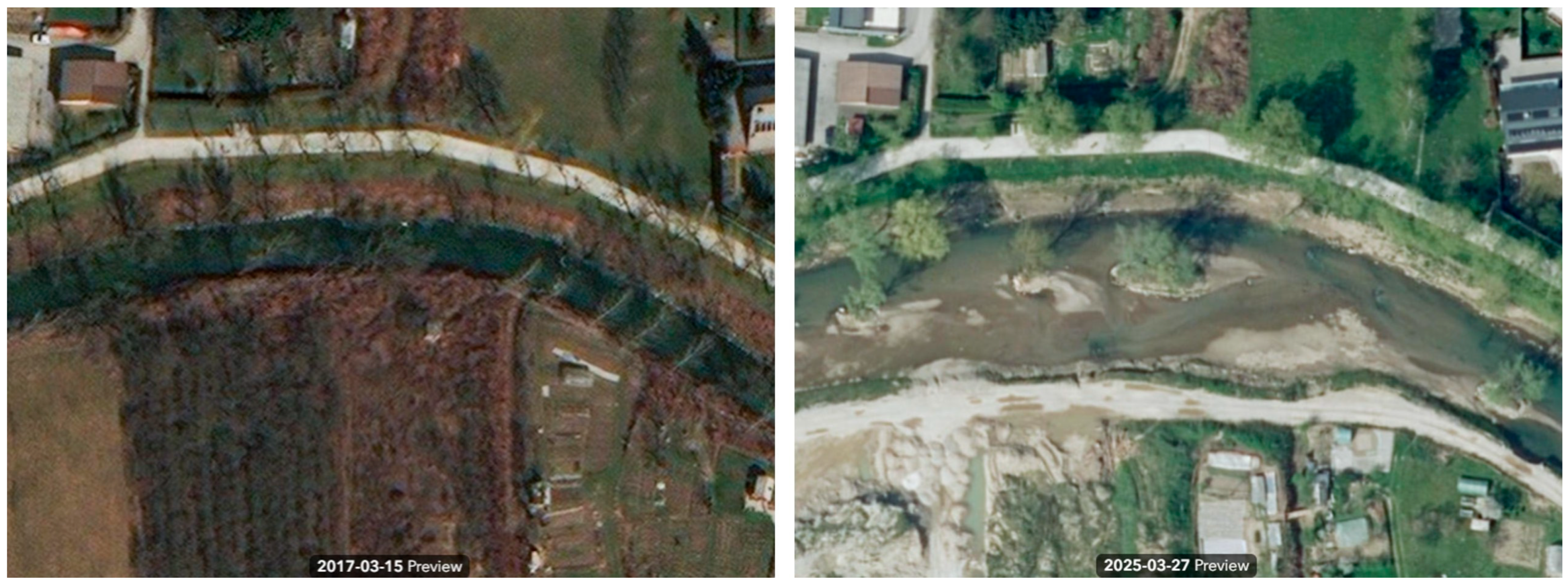
Figure 1. A section of the Mali graben before the restoration works in 2017 (left) and during the finalisation of restoration works in 2025 (right) (source: Esri [46]).
Infrastructures 11 00330 g001
Figure 2. Mali graben after restoration works in July 2026 (foto: Mark Bryan Alivio).
Infrastructures 11 00330 g002
Figure 3. Flood hazard map for Q100 (left) [48] and flood risk map for Q100 (right) [49] for SW part of the City of Ljubljana.
Infrastructures 11 00330 g003
Figure 4. Spatial map of the locations of the water temperature sensors installed in Mali graben (Ljubljana, Slovenia).
Infrastructures 11 00330 g004
Figure 5. Assessment of the condition of the Gradaščica-Mali graben (as critical infrastructure) before river restoration works.
Infrastructures 11 00330 g005
Figure 6. Assessment of the effect of natural hazard on the condition of the Gradaščica–Mali graben (as critical infrastructure) before river restoration works.
Infrastructures 11 00330 g006
Figure 7. Assessment of the effect of different protective measure approaches on the Gradaščica-Mali graben (as critical infrastructure). Namely, grey protective measures (left), NbSs (middle), and hybrid (right).
Infrastructures 11 00330 g007
Figure 8. Boxplots showing the distribution of water temperatures (°C) recorded at each location from 10 June 2026 to 7 July 2026, ordered from Bokalce weir (mg01) to downstream (mg09). Boxplot mg10 shows air temperature for comparison purposes. The boxplots illustrate the median, interquartile range, and full data range (whiskers).
Infrastructures 11 00330 g008
Figure 9. Time series of water temperature (°C) in Mali graben measured at nine locations from Bokalce weir (mg01) to downstream (mg09) from 10 June 2026 to 7 July 2026. Red-highlighted period indicates the considered June 2026 heatwave.
Infrastructures 11 00330 g009
Table 1. Descriptive statistics of water temperature data in Mali graben (mg01–mg09) and air temperature (mg10) from 10 June 2026 to 7 July 2026.
SensorMeanMedianStd. Dev.MinMax
mg0118.0118.321.9212.6021.91
mg0218.3018.682.0012.9422.70
mg0318.6818.932.2613.0223.97
mg0419.0219.082.5013.0725.20
mg0519.0519.082.5413.1225.23
mg0619.8419.593.0113.4127.24
mg0719.9019.643.0513.4427.25
mg0820.7520.893.1513.7227.13
mg0920.9721.293.1613.7126.94
mg1022.6222.355.049.3634.40
Disclaimer/Publisher’s Note: The statements, opinions and data contained in all publications are solely those of the individual author(s) and contributor(s) and not of MDPI and/or the editor(s). MDPI and/or the editor(s) disclaim responsibility for any injury to people or property resulting from any ideas, methods, instructions or products referred to in the content.