
A Digital Twin-Driven System for Road Maintenance: Integrating UAVs and AMRs for Automated Inspection and Measurement

 , , , , , , , , and
Abstract
1. Introduction
1.1. Context and Motivation
1.2. Current Challenges
1.3. State of the Art
1.3.1. Digital Twins in Infrastructure Asset Management
1.3.2. UAV-Based Inspection and Maintenance
1.3.3. Autonomous Mobile Robots for Road Assessment
1.3.4. Integration of Digital Twins, UAVs, and AMRs
1.4. Paper Contributions
1.5. Paper Structure
2. System Architecture
2.1. Digital Twin Framework
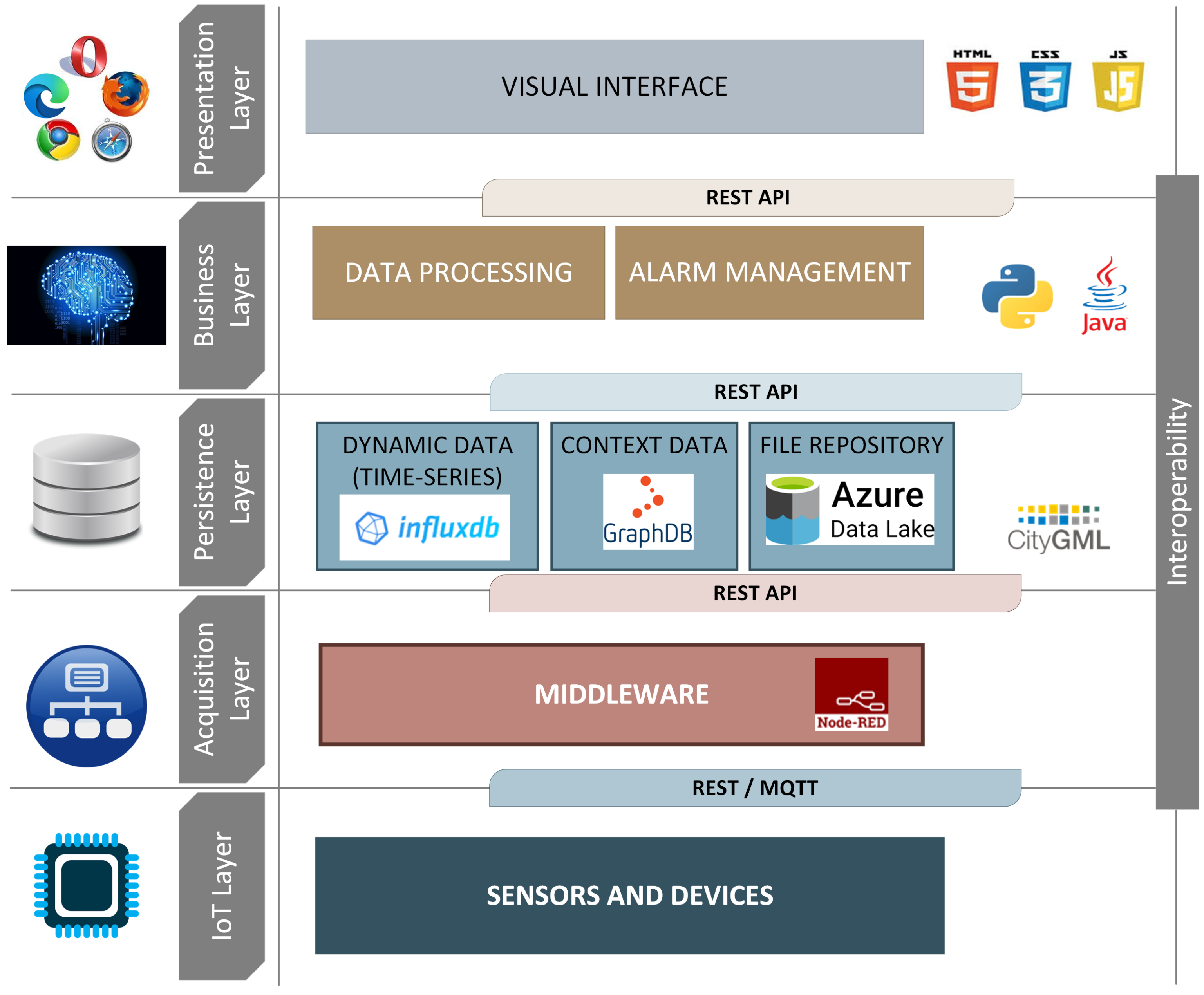
Architectural Overview and Implementation
2.2. UAV Component
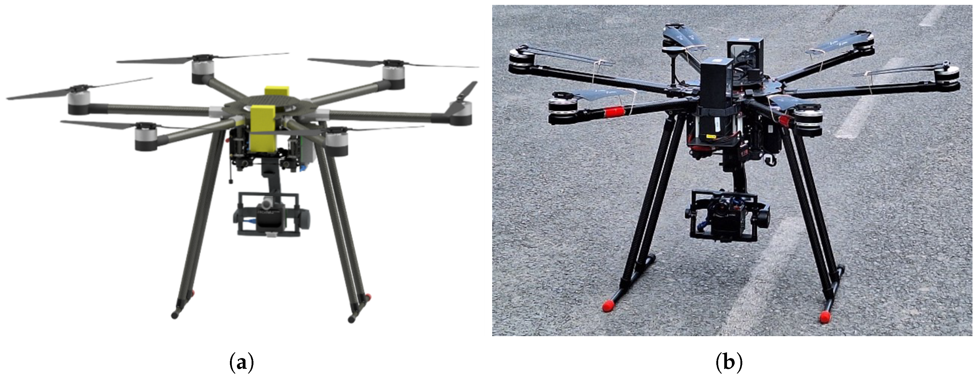
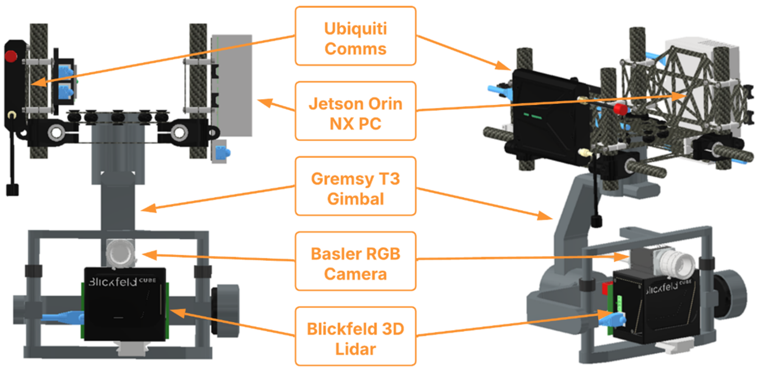
- It must be a UAV able to operate in outdoor road environments with sufficient payload capacity and flight endurance to carry the required perception sensors and complete inspection missions over extended road sections.
- It must have autonomous capabilities to self-localise, navigate along pre-planned routes, detect and analyse vertical traffic signs, identify obstacles and vegetation encroaching onto the road surface, and process sensor data in real time using onboard deep learning algorithms.
- It must be able to communicate with the DT, sending telemetry, detection results, retro-reflectivity measurements, and alarm notifications while receiving mission commands to execute autonomously.
UAV Systems Integration
2.3. AMR Component
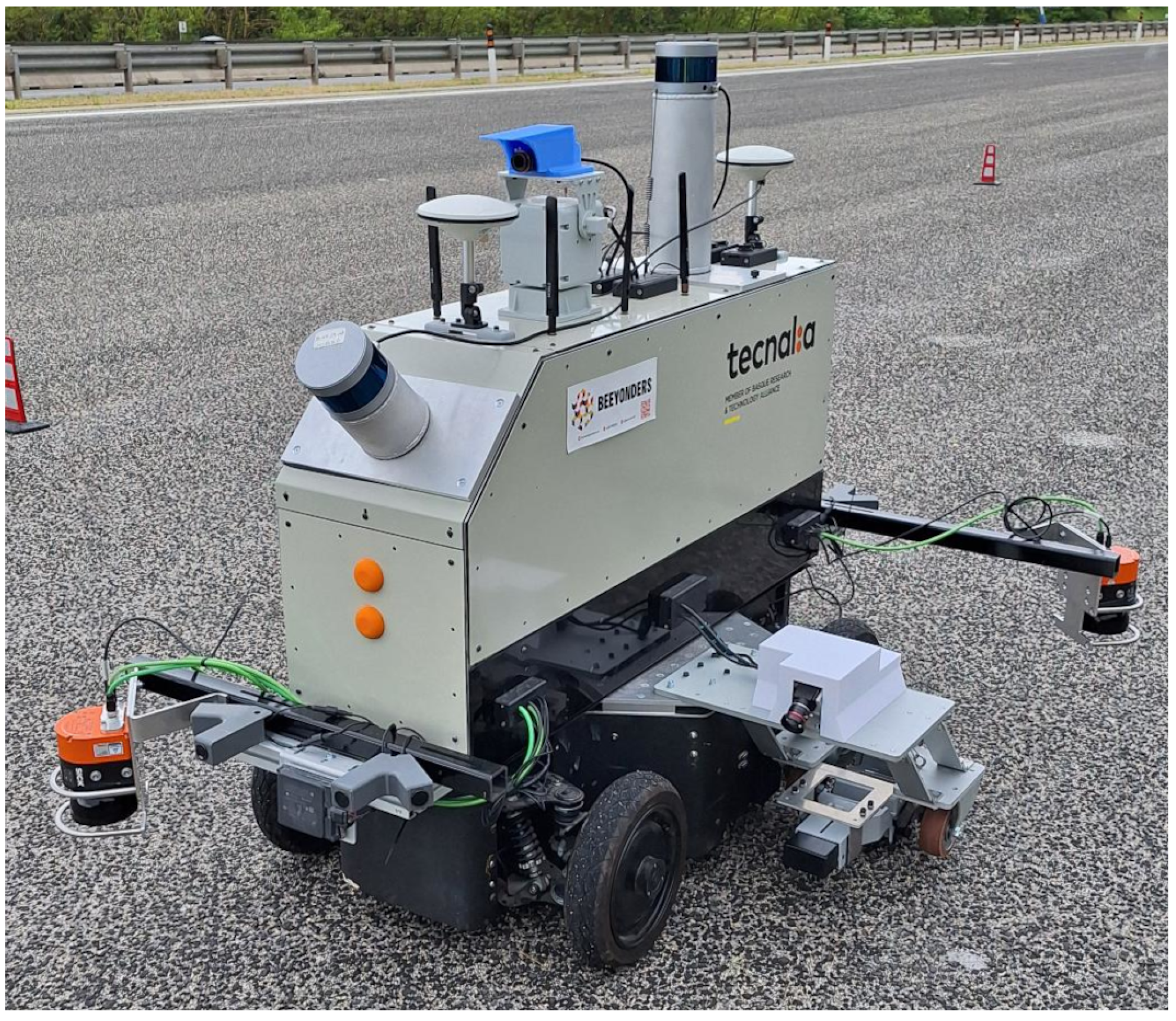
- It must be an AMR able to operate in outdoor road environments, so a car-like vehicle should be preferred as the base for the AMR.
- It must have autonomous capabilities to self-localise, navigate, detect and measure horizontal road signs, integrating the required sensors.
- It must be able to communicate with the DT, sending telemetry and measurements and receiving missions that must be carried out autonomously.
AMR Systems Integration
2.4. Operator Interface
2.5. Methodology and Workflow
3. System’s Autonomous Capabilities
3.1. UAV Autonomous Capabilities
3.1.1. Perception Module
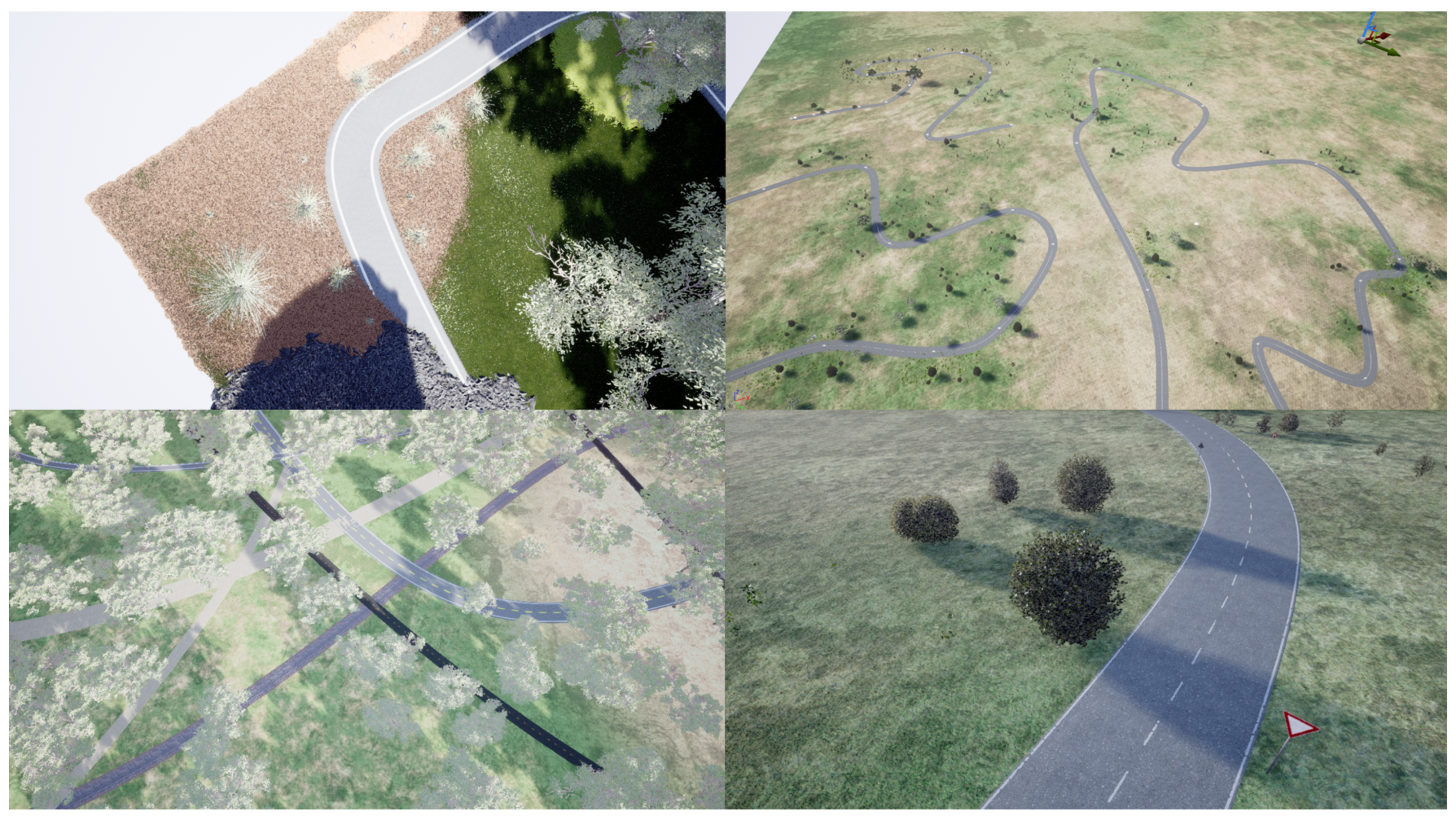
Synthetic Dataset Generation
Deep Learning Inference Pipeline
3.1.2. Control Module
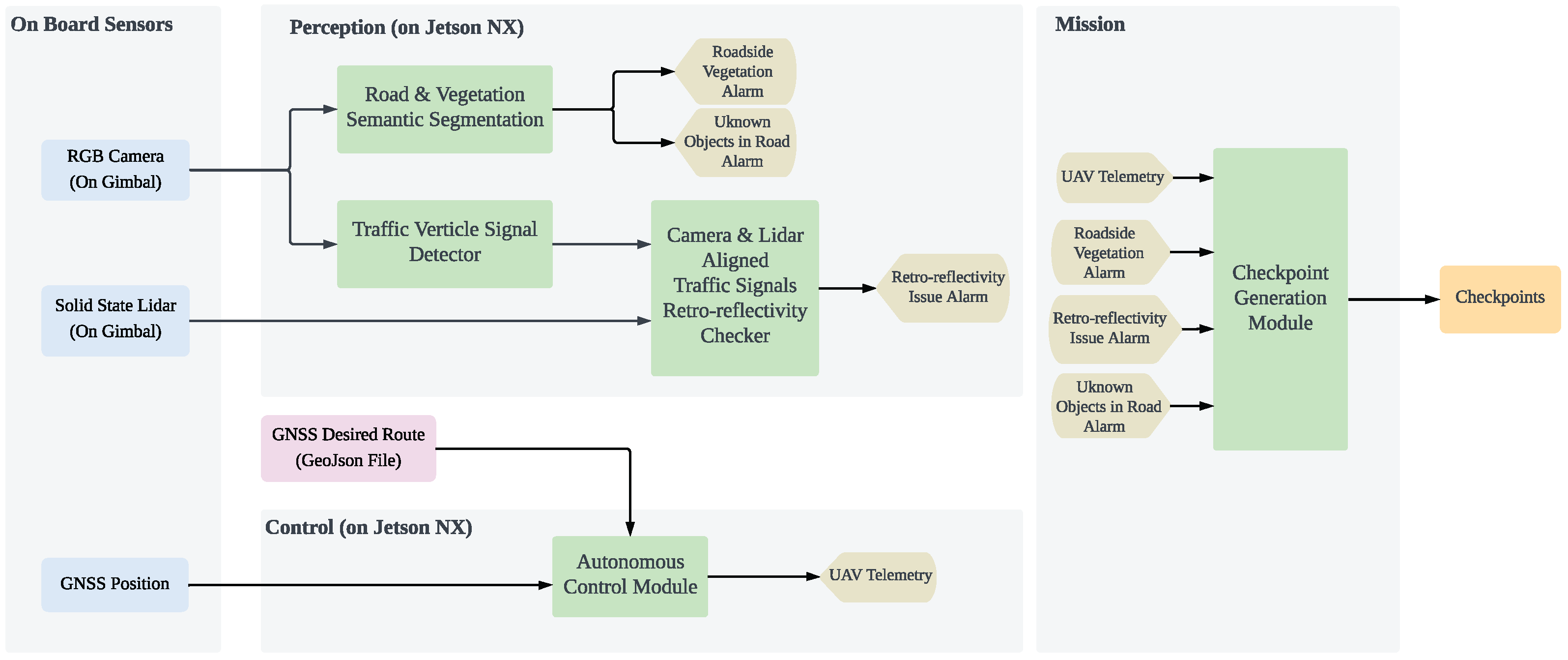
3.1.3. Mission Module
3.2. AMR Autonomous Capabilities
3.2.1. Outdoor Localisation and Navigation
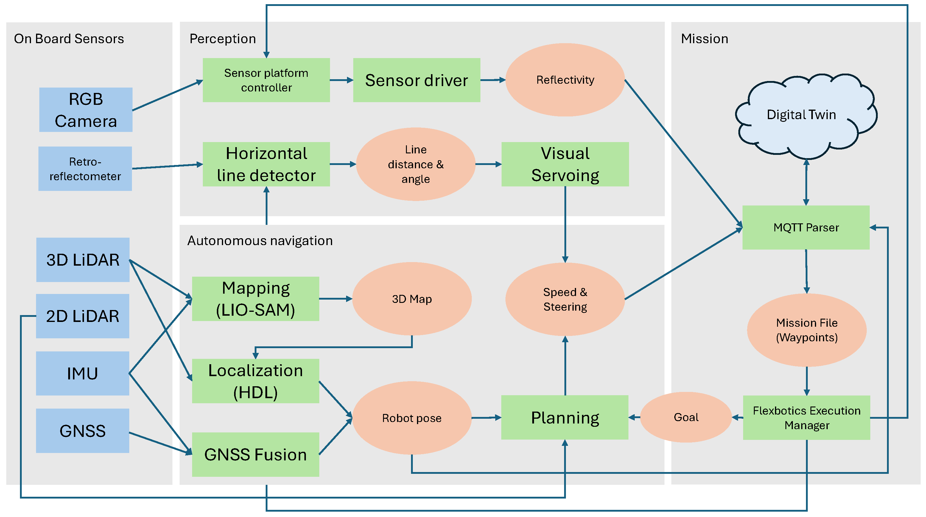
- 3D mapping and localisation: This solution is provided by a 3D navigation suite compiled by TECNALIA by integrating different off-the-shelf ROS components into a single, easily deployable localisation and navigation solution. This solution has been previously used successfully in different indoor industrial applications, including localisation and navigation in constrained spaces [27]. The suite is composed of two main components:
- –
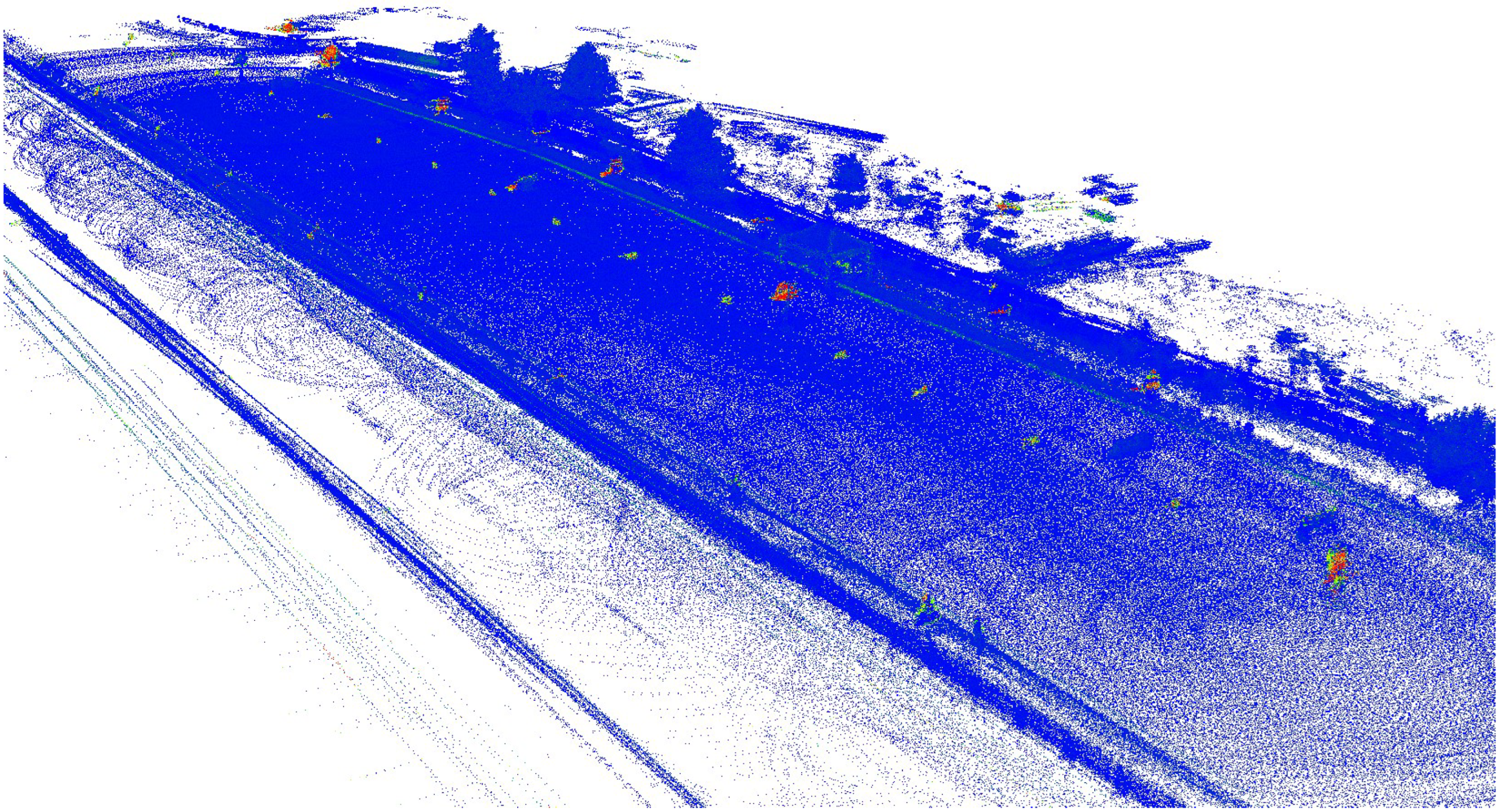
- Mapping module: The mapping process is performed using the LIO-SAM library [28]. LIO-SAM is a state-of-the-art odometry generation library based on LiDAR and IMU sensors. Sensor movement is accurately estimated by combining point-cloud matching with inertial measurement. The point-cloud matching is performed against a 3D representation created from invariant points detected in the point clouds. This 3D representation is dense enough to be used as a 3D map for later navigation.
- –
- Localisation module: For the 3D localisation part, the suite incorporates the HDL_localization library [29]. The localisation done by this library is based on a variant of the Normal Distribution Transform (NDT) point-cloud matching method against a global map. The system keeps track of the estimated position using an Unscented Kalman Filter. At each step, the estimated pose is updated using inertial measurement and then is refined using the mentioned NDT method. Since the maps generated by LIO-SAM are not geolocalised, a GPS fusion method is used to obtain the transformation between the local map poses and global UTM coordinates. This fusion is provided by the ROS robot_localization module [30], which provides an implementation of a Extended Kalman Filter (EKF), fusing GPS and IMU inputs for continuous global positioning of the robot in UTM coordinates.
- Inertial + GPS map-less localisation: In this approach, the 3D map used for localisation is replaced by a continuous pose estimator fusing odometry, inertial and GPS measurements. Odometry information is calculated using a custom fusion of GPS and vehicle speed provided by the CAN interface. The localisation, also based on the robot_localization pacakge, allows us to accurately estimate the robot’s relative pose in a local framework from its starting position. As in the 3D map-based system, an additional GPS integration layer provides the transformation from the local reference system to UTM coordinates.
- Planning: Basic planning functionality is provided by the standard ROS navigation stack. However, the map used for this planning is different depending on the localisation used:
- –
- In the case of the GPS localisation, planning is done on an empty map with only customised “lanes”, but no environment obstacles.
- –
- Planning over the 3D map module requires us to know the parts of the map that represent unsalvable obstacles. This is achieved by estimating the floor from the 3D map as an elevation map using the ROS grid_map library [31]. This 2.5D representation of the environment is then used to estimate the “transitable” space of the environment in the form of a “transitability” map that represents the areas of the environment that the robot can reach by its own means. This transitability map is the occupancy grid used by the standard ROS navigation stack for planning.
3.2.2. Horizontal Sign Detection and Sampling
3.2.3. Mission Management
4. Case Study: Application in Road Maintenance
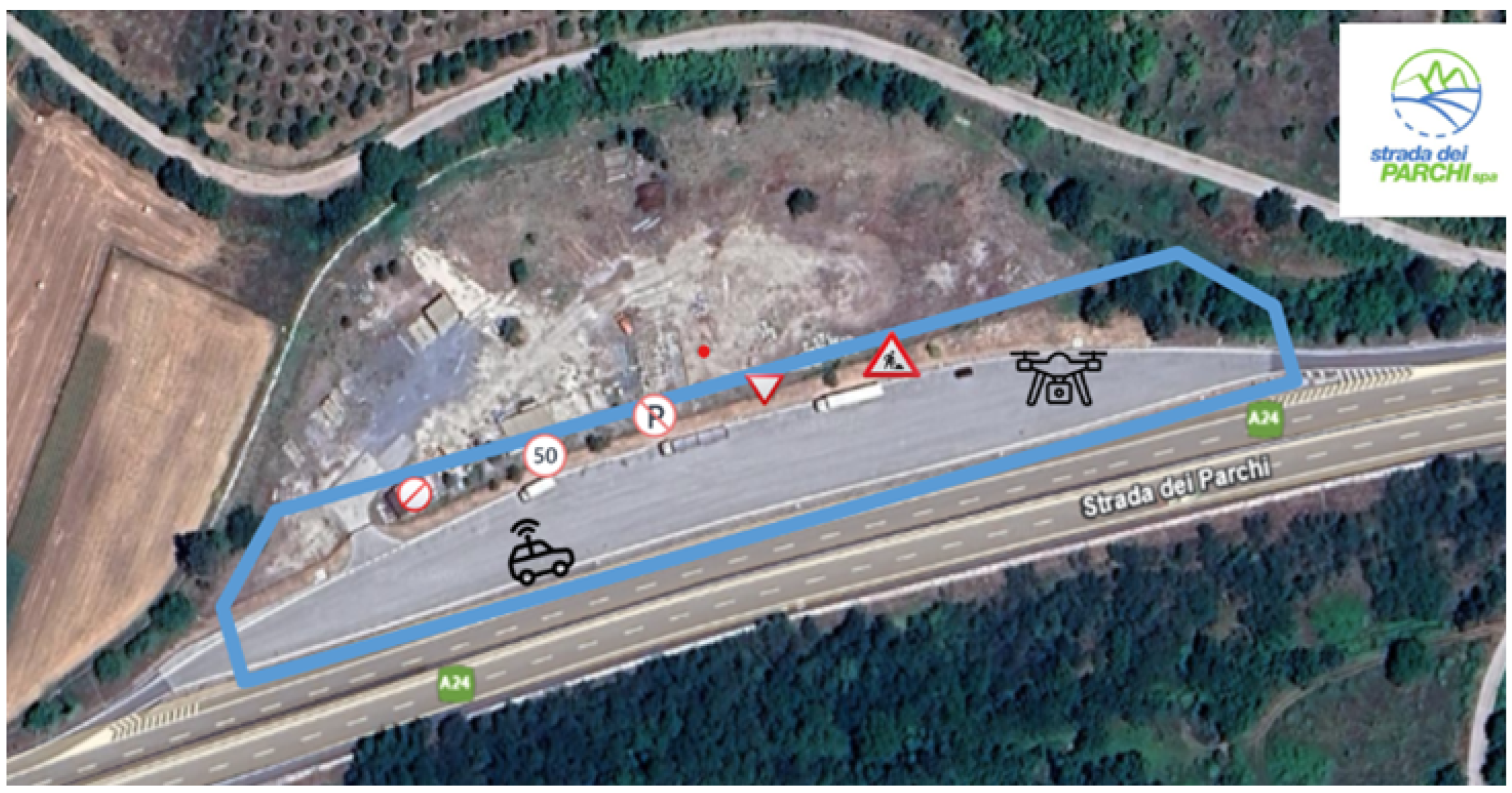
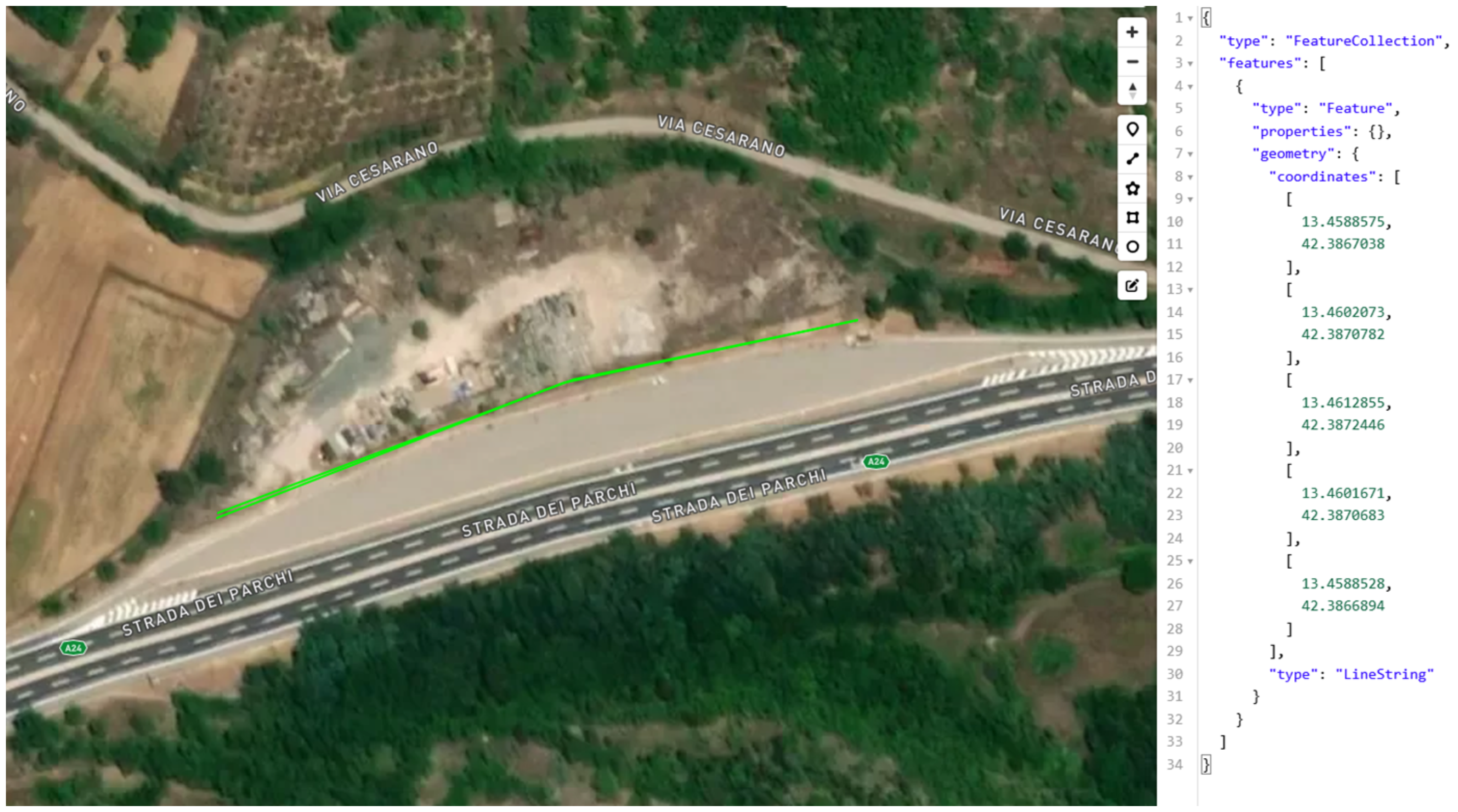
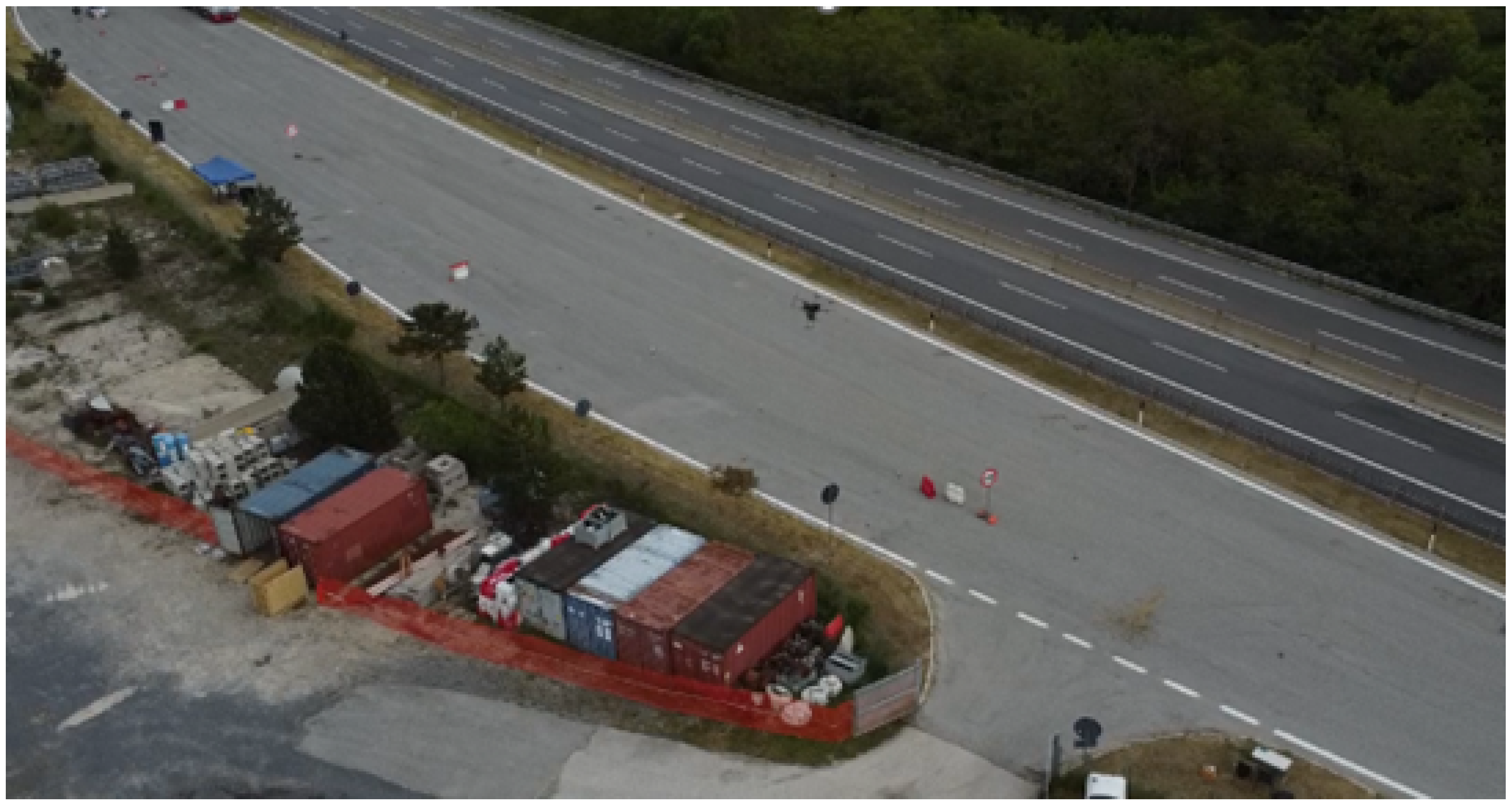
4.1. Study Area
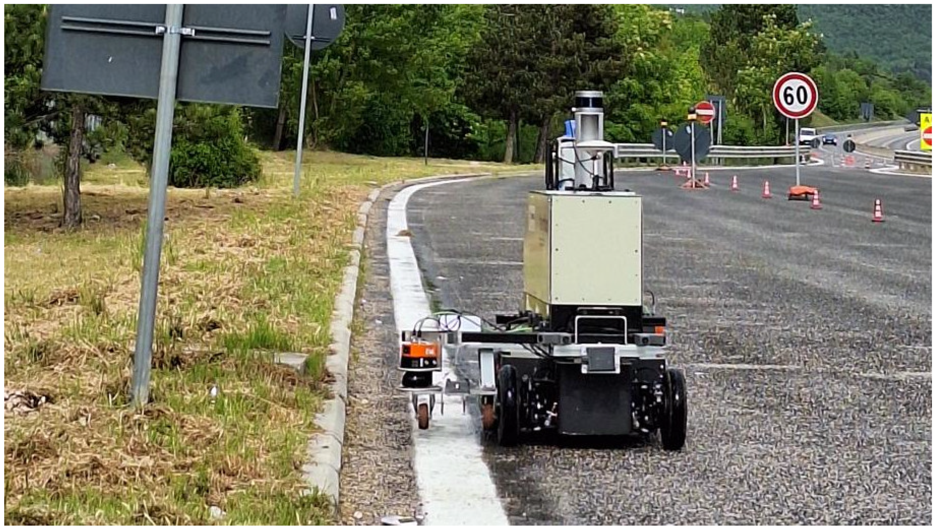
- An AMR for autonomous horizontal marking retro-reflectivity assessment.
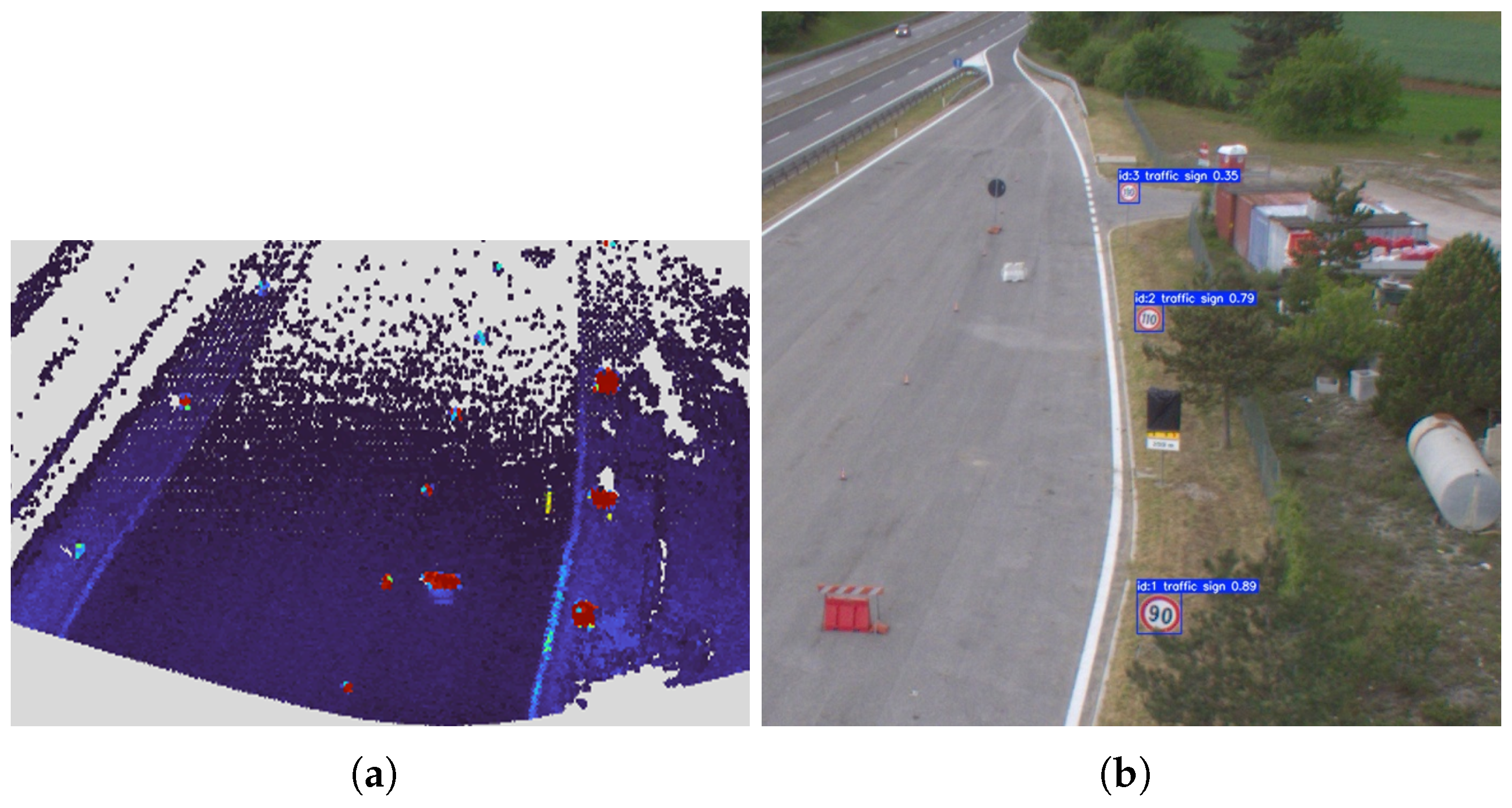
- A UAV for road obstacle detection, roadside vegetation detection, and vertical signage retro-reflectivity assessment.
- A DT for gathering and presenting data to operators, enabling them to manage maintenance and inspection tasks.
- Select the road section to be inspected and plan the autonomous agents’ routes using the DT’s tools.
- Deploy the UAV over the defined section to detect vegetation and obstacles and to assess vertical signs. Acquired data are uploaded to the DT.
- Deploy the AMR with a list of points or horizontal markings to inspect. Acquired measurements are uploaded to the DT.
- Analyse the uploaded data, validating retro-reflectivity measurements, identifying vegetation and obstacles, and assessing KPIs.
- Update the maintenance status with the newly acquired data.
4.2. System Deployment
4.2.1. Aerial Robot Deployment
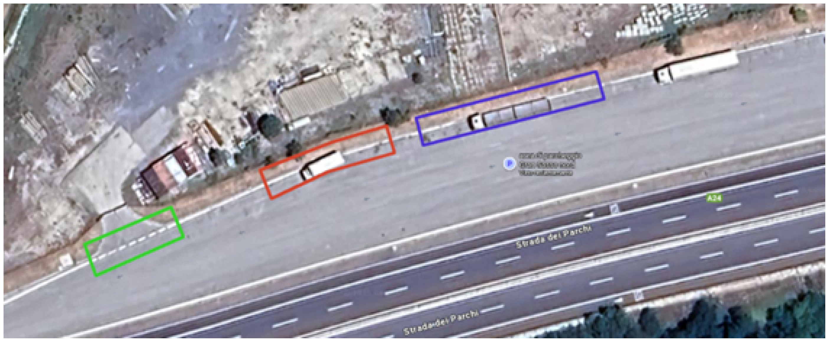
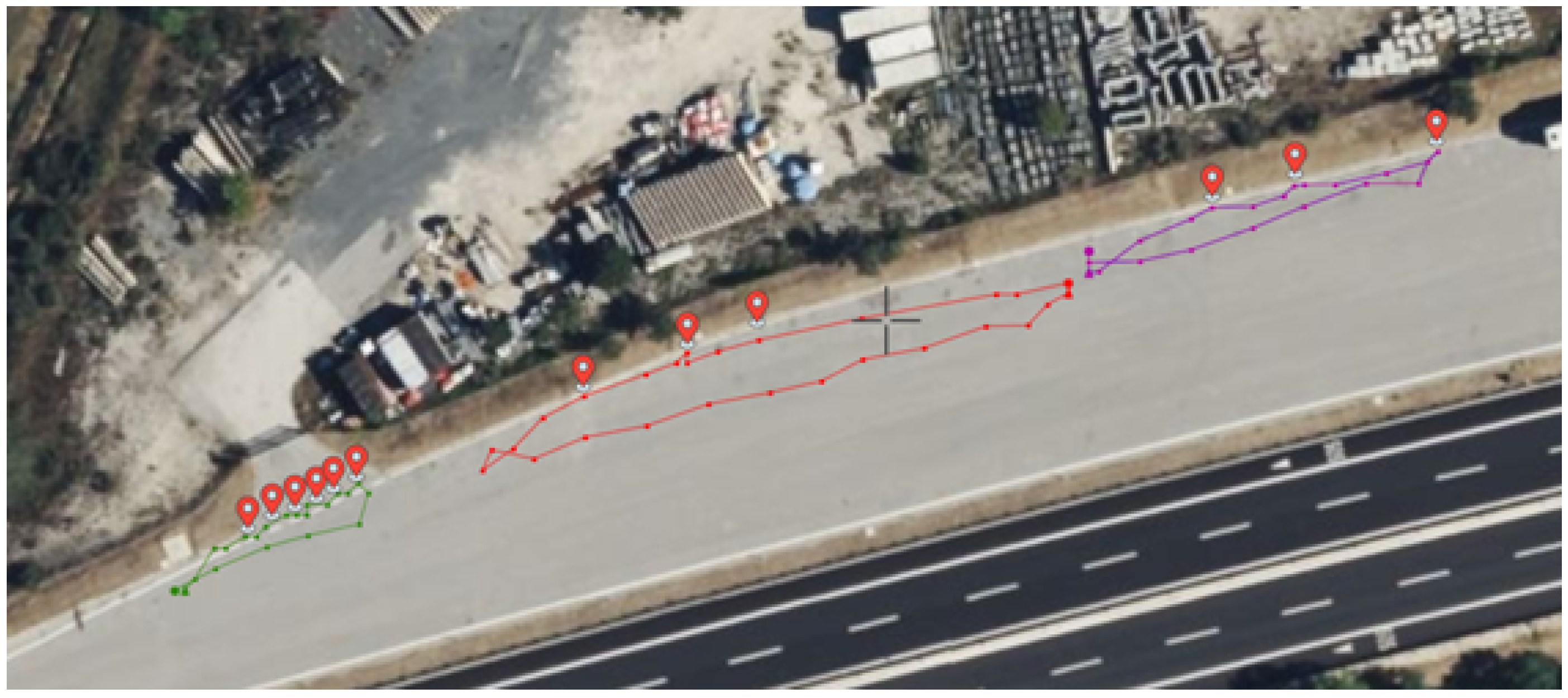
4.2.2. AMR Deployment
- Testing the autonomous localisation and navigation capabilities for both systems, based on 3D maps and GPS + inertial data.
- Testing the bidirectional communication with the DT, including the transmission of telemetry and retro-reflectivity measurements to the DT and the reception of missions from it.
- Testing the system’s capability to effectively measure the retro-reflectivity of horizontal road markings, including accurate sensor positioning over them.
- Testing the capability to autonomously complete missions composed of several arbitrary measurement locations.
- A mission measuring several points in a continuous line along a straight section of the road.
- A mission measuring several points in a continuous line along a curved section of the road.
- A mission measuring a discontinuous-line section.
4.3. Technical Results
4.3.1. UAV Surveillance Results
Traffic Sign Detection Validation
Semantic Segmentation Performance
Retro-Reflectivity Analysis
4.3.2. AMR Localisation, Navigation, and Measurement Results
5. Impact Assessment
5.1. Scope and Objective
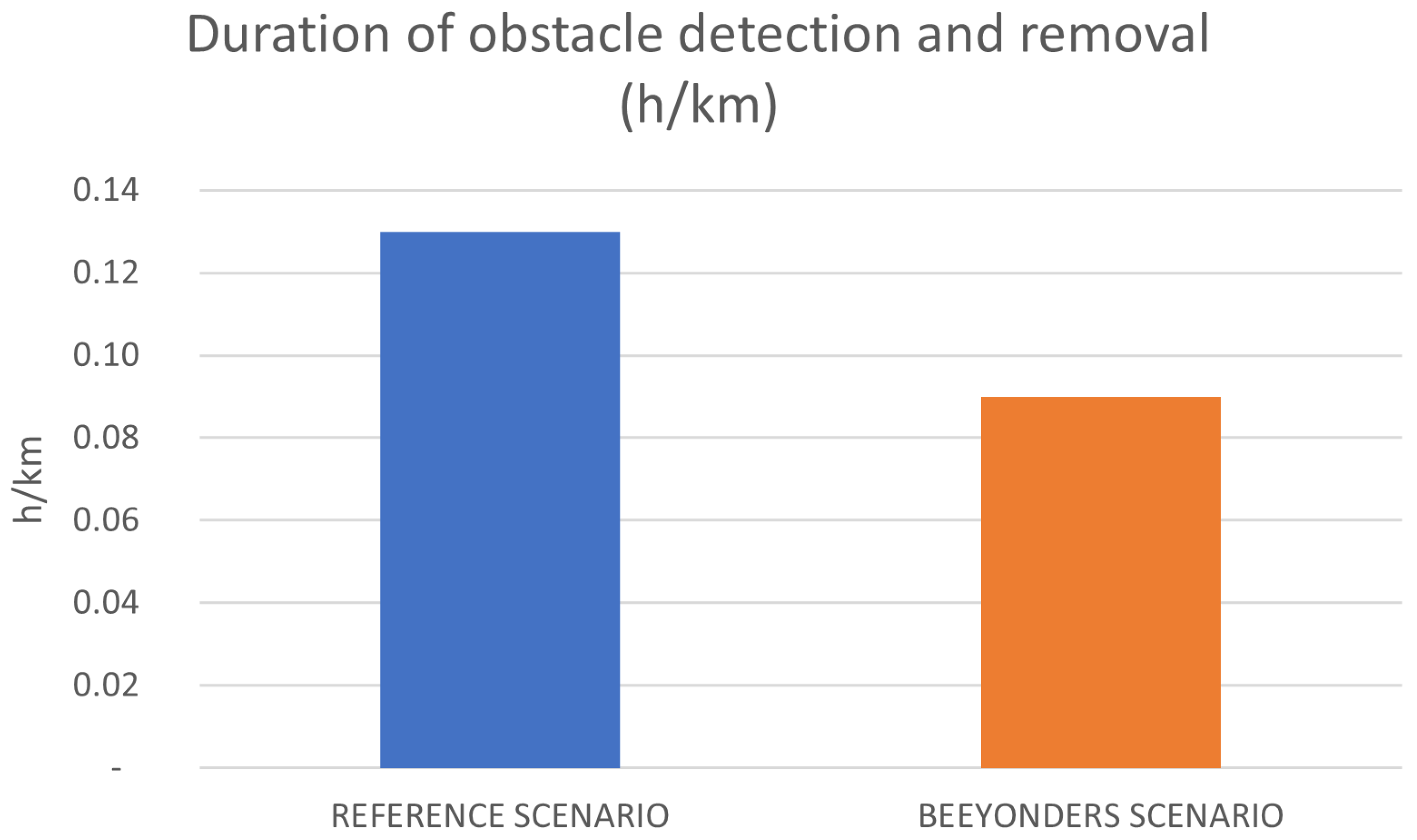
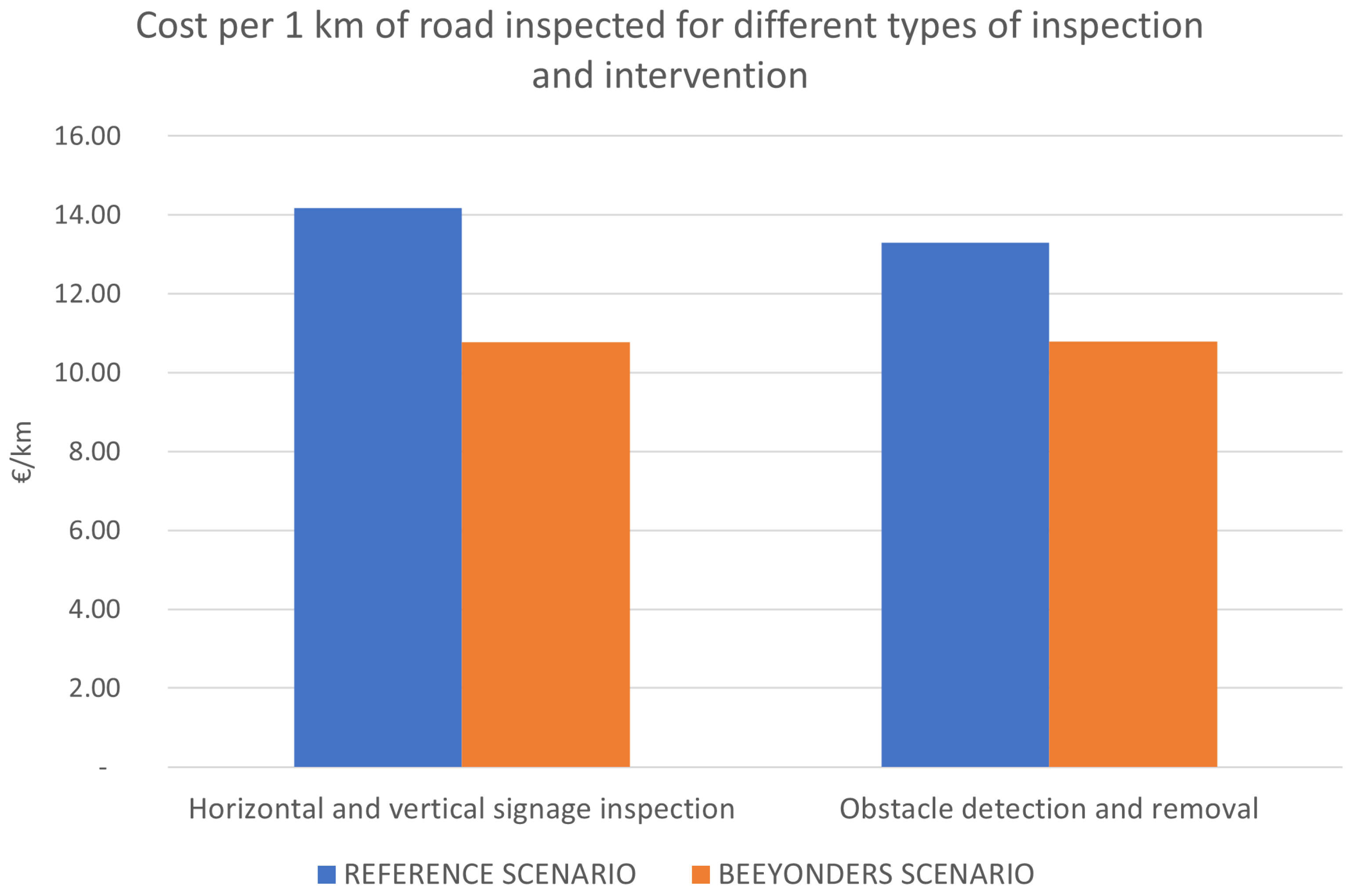
- In the reference scenario, inspections rely on patrol vehicles and manual visual observations. Obstacle detection is carried out through daily patrols using four vehicles (two per traffic direction), each operated by a two-person crew covering approximately 150 km per day. When obstacles or hazards are detected, a mobile work site—comprising signalling vehicles and a removal crew—is deployed to secure the area and perform the intervention. Vertical signage inspections are conducted once per year using visual checks, supported by portable retro-reflectometers when necessary, typically carried out by two operators using a patrol vehicle. Horizontal road marking retro-reflectivity is measured using a dedicated inspection vehicle equipped with measurement instrumentation and operated by a single driver during periodic inspection campaigns.
- The BEEYONDERS scenario introduces an automated inspection system integrating UAVs, an autonomous inspection vehicle, and a digital twin platform. UAVs perform aerial monitoring of roadside infrastructure, enabling the detection of obstacles and assessment of vertical signage conditions. Horizontal road markings are inspected using the AMR equipped with retro-reflectivity sensors, operating autonomously along the roadway. Inspection data from both platforms are transmitted to the digital twin environment, enabling centralised data processing, performance monitoring, and data-driven maintenance planning, while reducing the need for continuous on-road patrols.
5.2. Functional Unit and System Boundaries
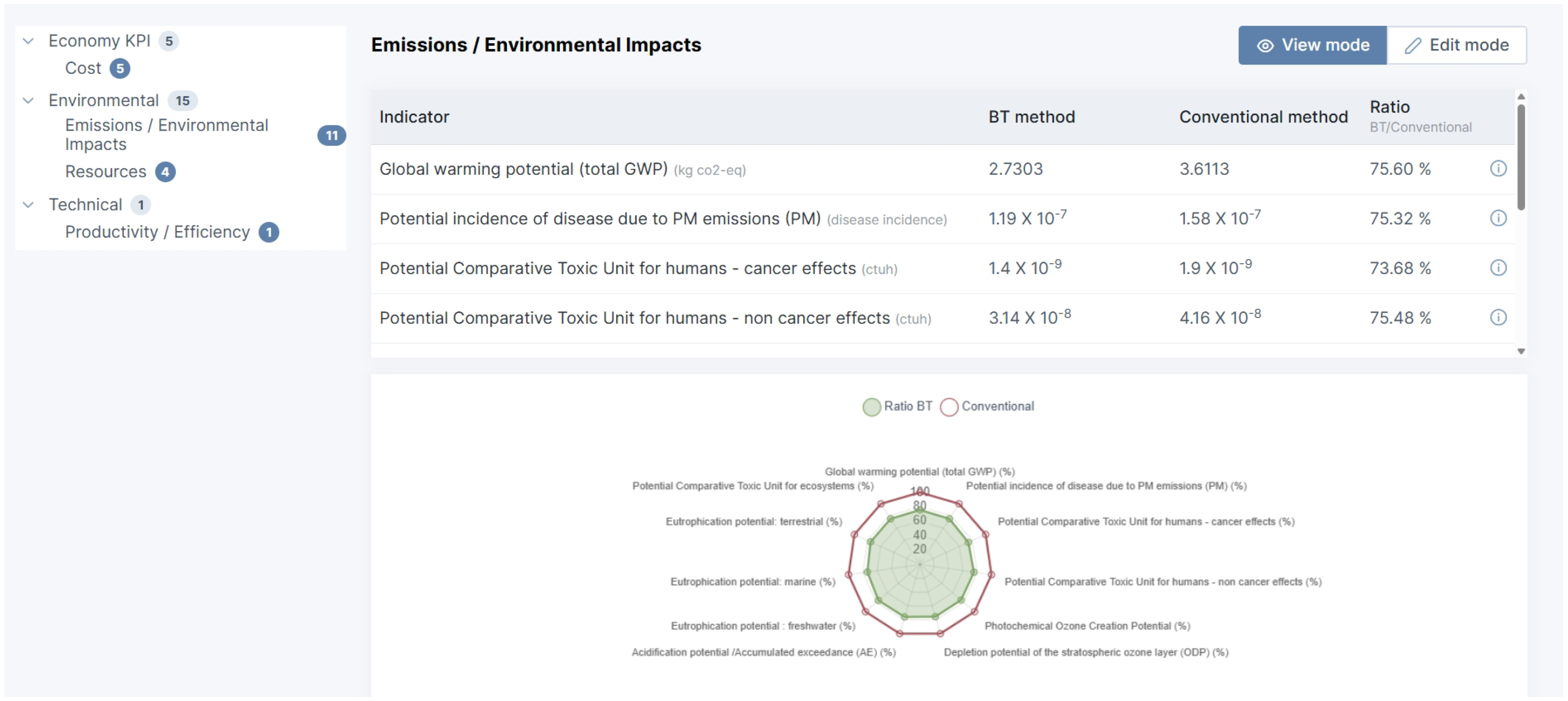
5.3. Environmental Analysis
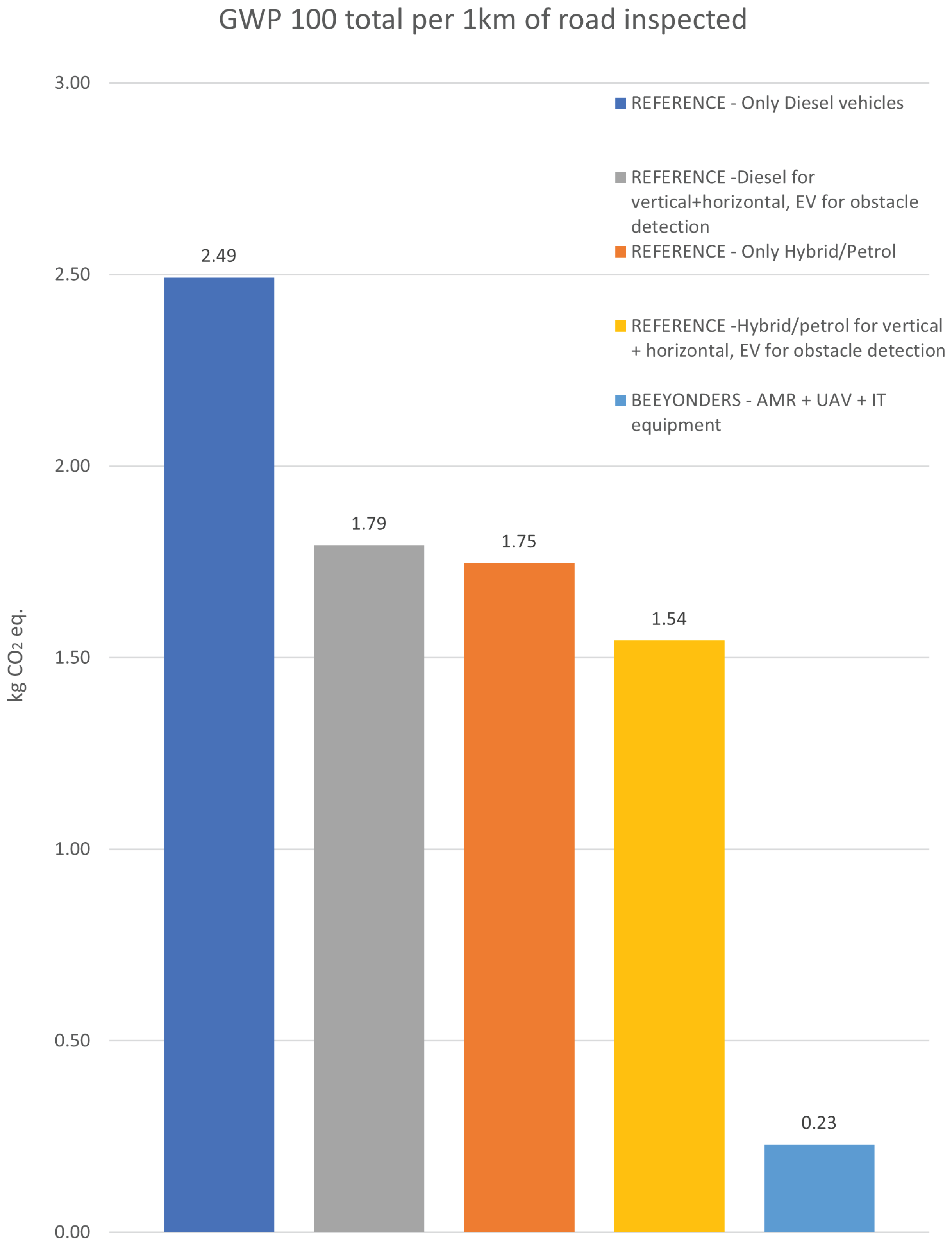
- Only diesel vehicles used (EURO 5 standard);
- Only hybrid/petrol vehicles used (EURO 5 standard);
- Diesel for vertical and horizontal inspection, EV for obstacle detection;
- Hybrid/petrol for vertical and horizontal inspection, EV for obstacle detection.
5.4. Economic and Productivity Analysis
6. Discussion
6.1. Technical Advantages
6.2. Limitations and Challenges
6.2.1. UAV Sensor Accuracy in Adverse Weather
6.2.2. UAV Computational Demands of Real-Time Data Processing
6.2.3. AMR General Limitations
7. Conclusions and Future Work
Author Contributions
Funding
Data Availability Statement
Acknowledgments
Conflicts of Interest
Abbreviations
| AEC | Architecture, Engineering, and Construction |
| AI | Artificial Intelligence |
| AMR | Autonomous Mobile Robot |
| API | Application Programming Interface |
| BIM | Building Information Modelling |
| CAD | Computer-Aided Design |
| CAN | Controller Area Network |
| DT | Digital Twin |
| EKF | Extended Kalman Filter |
| ETSC | European Transport Safety Council |
| EU | European Union |
| FEM | Flexbotics Execution Manager |
| FSM | Finite State Machine |
| GDP | Gross Domestic Product |
| GNSS | Global Navigation Satellite System |
| GPS | Global Positioning System |
| GTSDB | German Traffic Sign Detection Benchmark |
| IMU | Inertial Measurement Unit |
| IoT | Internet of Things |
| KPI | Key Performance Indicator |
| LCIA | Life Cycle Impact Assessment |
| LiDAR | Light Detection And Ranging |
| MTOW | Maximum Take-Off Weight |
| NDT | Normal Distribution Transform |
| NEMA | National Electrical Manufacturers Association |
| PID | Proportional–Integral–Derivative |
| RGB | Red–Green–Blue |
| ROS | Robot Operating System |
| RTK-GPS | Real-Time Kinematics Global Positioning System |
| SLAM | Simultaneous Localisation And Mapping |
| SSMs | Smach State Machines |
| UAV | Unmanned Aerial Vehicle |
| UTM | Universal Transverse Mercator |
References
- Brons, M.; Dijkstra, L.; Ibáñez, J.N.; Poelman, H. Road Infrastructure in Europe: Road Length and Its Impact on Road Performance; Number WP 03/2022; Publications Office of the European Union: Luxembourg, 2022. [Google Scholar]
- Eurostat. Expenditure on Road Transport Vehicles and Road Infrastructure. 2026. Available online: https://ec.europa.eu/eurostat/databrowser/view/road_ec_invest/default/table?lang=en (accessed on 11 March 2026).
- European Comission—Directorate-General for Mobility and Transport. EU Road Fatalities Drop by 3% in 2024, but Progress Remains Slow. 2025. Available online: https://transport.ec.europa.eu/news-events/news/eu-road-fatalities-drop-3-2024-progress-remains-slow-2025-03-18_en (accessed on 11 March 2026).
- European Transport Safety Council. Up to 40% of Road Deaths in Europe Are Work-Related. 2017. Available online: https://etsc.eu/up-to-40-of-road-deaths-in-europe-are-work-related/ (accessed on 11 March 2026).
- Xu, J.; N’Zebo, R.A.; Taha-Abdalgadir, H.; d’Avigneau, A.M.; Palin, D.; Wei, R.; Hadjidemetriou, G.; Schaefer, S.; de Silva, L.; Al-Tabbaa, A.; et al. Highway digital twin-enabled Autonomous Maintenance Plant: A perspective. Data-Centric Eng. 2024, 5, e24. [Google Scholar] [CrossRef] [Scilit]
- Yan, Y.; Ni, L.; Sun, L.; Wang, Y.; Zhou, J. Digital twin enabling technologies for advancing road engineering and lifecycle applications. Engineering 2025, 44, 184–206. [Google Scholar] [CrossRef] [Scilit]
- Adibfar, A.; Razkenari, M.; Costin, A. Review and assessment of technical and legal challenges in application of unmanned aerial vehicles in monitoring and inspection of bridges. Intell. Transp. Infrastruct. 2023, 2, liad023. [Google Scholar] [CrossRef] [Scilit]
- Soni, S. DROIDS—Information Maintenance and Availability. 2024. Available online: https://www.cedr.eu/docs/view/67bf3ab3bf2a1-en (accessed on 11 March 2026).
- Omrany, H.; Al-Obaidi, K.M.; Husain, A.; Ghaffarianhoseini, A. Digital Twins in the Construction Industry: A Comprehensive Review of Current Implementations, Enabling Technologies, and Future Directions. Sustainability 2023, 15, 908. [Google Scholar] [CrossRef] [Scilit]
- Opoku, D.G.J.; Perera, S.; Osei-Kyei, R.; Rashidi, M. Digital twin application in the construction industry: A literature review. J. Build. Eng. 2021, 40, 102726. [Google Scholar] [CrossRef] [Scilit]
- Chen, X.; Liu, C.; Chen, L.; Zhu, X.; Zhang, Y.; Wang, C. A Pavement Crack Detection and Evaluation Framework for a UAV Inspection System Based on Deep Learning. Appl. Sci. 2024, 14, 1157. [Google Scholar] [CrossRef] [Scilit]
- Aldoski, Z.N.; Koren, C. Assessment of traffic sign retroreflectivity for autonomous vehicles: A comparison between handheld retroreflectometer and LiDAR data. Arch. Transp. 2024, 70, 7–26. [Google Scholar] [CrossRef] [Scilit]
- Yang, X.; Zhang, J.; Liu, W.; Jing, J.; Zheng, H.; Xu, W. Automation in road distress detection, diagnosis and treatment. J. Road Eng. 2024, 4, 1–26. [Google Scholar] [CrossRef] [Scilit]
- Huang, X.; Houshangi, N. A vision-based autonomous lane following system for a mobile robot. In 2009 IEEE International Conference on Systems, Man and Cybernetics; IEEE: Piscataway, NJ, USA, 2009; pp. 2344–2349. [Google Scholar] [CrossRef] [Scilit]
- Khanmohamadi, M.; Guerrieri, M. Advanced Sensor Technologies in CAVs for Traditional and Smart Road Condition Monitoring: A Review. Sustainability 2024, 16, 8336. [Google Scholar] [CrossRef] [Scilit]
- Munasinghe, I.; Perera, A.; Deo, R.C. A Comprehensive Review of UAV-UGV Collaboration: Advancements and Challenges. J. Sens. Actuator Netw. 2024, 13, 81. [Google Scholar] [CrossRef] [Scilit]
- Hakimi, O.; Liu, H.; Abudayyeh, O.; Houshyar, A.; Almatared, M.; Alhawiti, A. Data Fusion for Smart Civil Infrastructure Management: A Conceptual Digital Twin Framework. Buildings 2023, 13, 2725. [Google Scholar] [CrossRef] [Scilit]
- Node-RED. Available online: https://nodered.org/ (accessed on 11 March 2026).
- GraphDB. Available online: https://graphdb.ontotext.com/ (accessed on 11 March 2026).
- InfluxDB. Available online: https://www.influxdata.com/ (accessed on 11 March 2026).
- Quigley, M.; Gerkey, B.; Conley, K.; Faust, J.; Foote, T.; Leibs, J.; Berger, E.; Wheeler, R.; Ng, A. ROS: An open-source Robot Operating System. In ICRA Workshop on Open Source Software; IEEE: Piscataway, NJ, USA, 2009; Volume 3, p. 5. [Google Scholar]
- Epic Games. Unreal Engine. Available online: https://www.unrealengine.com (accessed on 11 March 2026).
- Shah, S.; Dey, D.; Lovett, C.; Kapoor, A. AirSim: High-Fidelity Visual and Physical Simulation for Autonomous Vehicles. arXiv 2017, arXiv:1705.05065. [Google Scholar]
- Xiao, T.; Liu, Y.; Zhou, B.; Jiang, Y.; Sun, J. Unified Perceptual Parsing for Scene Understanding. In Proceedings of the Computer Vision—ECCV 2018; Ferrari, V., Hebert, M., Sminchisescu, C., Weiss, Y., Eds.; Springer: Cham, Switzerland, 2018; pp. 432–448. [Google Scholar]
- Ge, Z.; Liu, S.; Wang, F.; Li, Z.; Sun, J. YOLOX: Exceeding YOLO Series in 2021. arXiv 2021, arXiv:2107.08430. [Google Scholar] [CrossRef] [Scilit]
- Ai, C.; Tsai, Y.J. An automated sign retroreflectivity condition evaluation methodology using mobile LIDAR and computer vision. Transp. Res. Part C Emerg. Technol. 2016, 63, 96–113. [Google Scholar] [CrossRef] [Scilit]
- Villaverde, I.; Urquiza, A.; Outón, J.L. A Reconfigurable UGV for Modular and Flexible Inspection Tasks in Nuclear Sites. Robotics 2024, 13, 110. [Google Scholar] [CrossRef] [Scilit]
- Shan, T.; Englot, B.; Meyers, D.; Wang, W.; Ratti, C.; Daniela, R. LIO-SAM: Tightly-coupled Lidar Inertial Odometry via Smoothing and Mapping. In IEEE/RSJ International Conference on Intelligent Robots and Systems (IROS); IEEE: Piscataway, NJ, USA, 2020; pp. 5135–5142. [Google Scholar]
- Koide, K.; Miura, J.; Menegatti, E. A portable three-dimensional LIDAR-based system for long-term and wide-area people behavior measurement. Int. J. Adv. Robot. Syst. 2019, 16, 1729881419841532. [Google Scholar] [CrossRef] [Scilit]
- Moore, T.; Stouch, D. A Generalized Extended Kalman Filter Implementation for the Robot Operating System. In Proceedings of the 13th International Conference on Intelligent Autonomous Systems (IAS-13); Springer: Cham, Switzerland, 2014. [Google Scholar]
- Fankhauser, P.; Hutter, M. A Universal Grid Map Library: Implementation and Use Case for Rough Terrain Navigation. In Robot Operating System (ROS)—The Complete Reference (Volume 1); Koubaa, A., Ed.; Springer: Cham, Switzerland, 2016; Chapter 5. [Google Scholar] [CrossRef] [Scilit]
- Community, S.D.M. Smart Data Models. 2023. Available online: https://github.com/smart-data-models (accessed on 30 March 2026).
- Herrero, H.; Outón, J.L.; Puerto, M.; Sallé, D.; López de Ipiña, K. Enhanced Flexibility and Reusability through State Machine-Based Architectures for Multisensor Intelligent Robotics. Sensors 2017, 17, 1249. [Google Scholar] [CrossRef] [Scilit] [PubMed]
- Bohren, J.; Cousins, S. The SMACH High-Level Executive [ROS News]. IEEE Robot. Autom. Mag. 2010, 17, 18–20. [Google Scholar] [CrossRef] [Scilit]
- Ministero delle Infrastrutture edei Trasporti. Codice della Strada. 2024. Available online: https://www.mit.gov.it/documentazione/codice-della-strada (accessed on 11 March 2026).
- UNI EN 1436:2018; Materiali Per Segnaletica Orizzontale—Prestazioni della Segnaletica Orizzontale per gli Utenti della Strada e Metodi di Prova. UNI—Ente Italiano di Normazione: Milan, Italy, 2018.
- UNI EN 12899-1:2008; Segnaletica Verticale Permanente—Requisiti per Segnali Nuovi Fissi non Retroriflettenti e Retroriflettenti, Inclusi Quelli Illuminati Esternamente e Quelli Transilluminati. UNI—Ente Italiano di Normazione: Milan, Italy, 2008.
- Stipanovic, I.; Skaric, S.; Kucinic, L. D2.3 LCA/LCC KPIs, BEEYONDERS. 2023. Available online: https://beeyonders.eu/wp-content/uploads/2025/12/D2.3-LCALCC-KPIs.pdf (accessed on 11 March 2026).
- ISO 14044:2006; Environmental Management—Life Cycle Assessment—Requirements and Guidelines. International Organization for Standardization: Geneva, Switzerland, 2006.
- EN 15804; Sustainability of Construction Works—Environmental Product Declarations—Core Rules for the Product Category of Construction Products. European Committee for Standardization (CEN): Brussels, Belgium, 2012.
- Wernet, G.; Bauer, C.; Steubing, B.; Reinhard, J.; Moreno-Ruiz, E.; Weidema, B. The ecoinvent database version 3 (part I): Overview and methodology. Int. J. Life Cycle Assess. 2016, 21, 1218–1230. [Google Scholar] [CrossRef] [Scilit]
- Castel-Branco, A.P.; Ribau, J.P.; Silva, C.M. Taxi Fleet Renewal in Cities with Improved Hybrid Powertrains: Life Cycle and Sensitivity Analysis in Lisbon Case Study. Energies 2015, 8, 9509–9540. [Google Scholar] [CrossRef] [Scilit]
- RICS. Life Cycle Costing, 1st ed.; Technical Report; RICS Royal Institution of Chartered Surveyors: London, UK, 2016. [Google Scholar]
- istat.it. Italy’s Economic Outlook 2025–2026. Available online: https://www.istat.it/en/press-release/italys-economic-outlook-2025-2026-2/ (accessed on 14 March 2026).
- istat.it. Hourly Wages by Employees Class. 2023. Available online: https://esploradati.istat.it/databrowser/#/en/dw/categories/{I}{T}1,{Z}0500{L}{A}{B},1.0/{L}{A}{B}_{E}{M}{P}{L}{W}{A}{G}{E}/{D}{C}{S}{C}_{R}{A}{C}{L}{I}/{I}{T}1,533_957_{D}{F}_{D}{C}{S}{C}_{R}{A}{C}{L}{I}_6,1.0 (accessed on 14 March 2026).










| Training Data | Recall | mAP@0.5 |
|---|---|---|
| Synthetic only | 0.928 | 0.899 |
| Hybrid (Synthetic + real) | 0.959 | 0.895 |
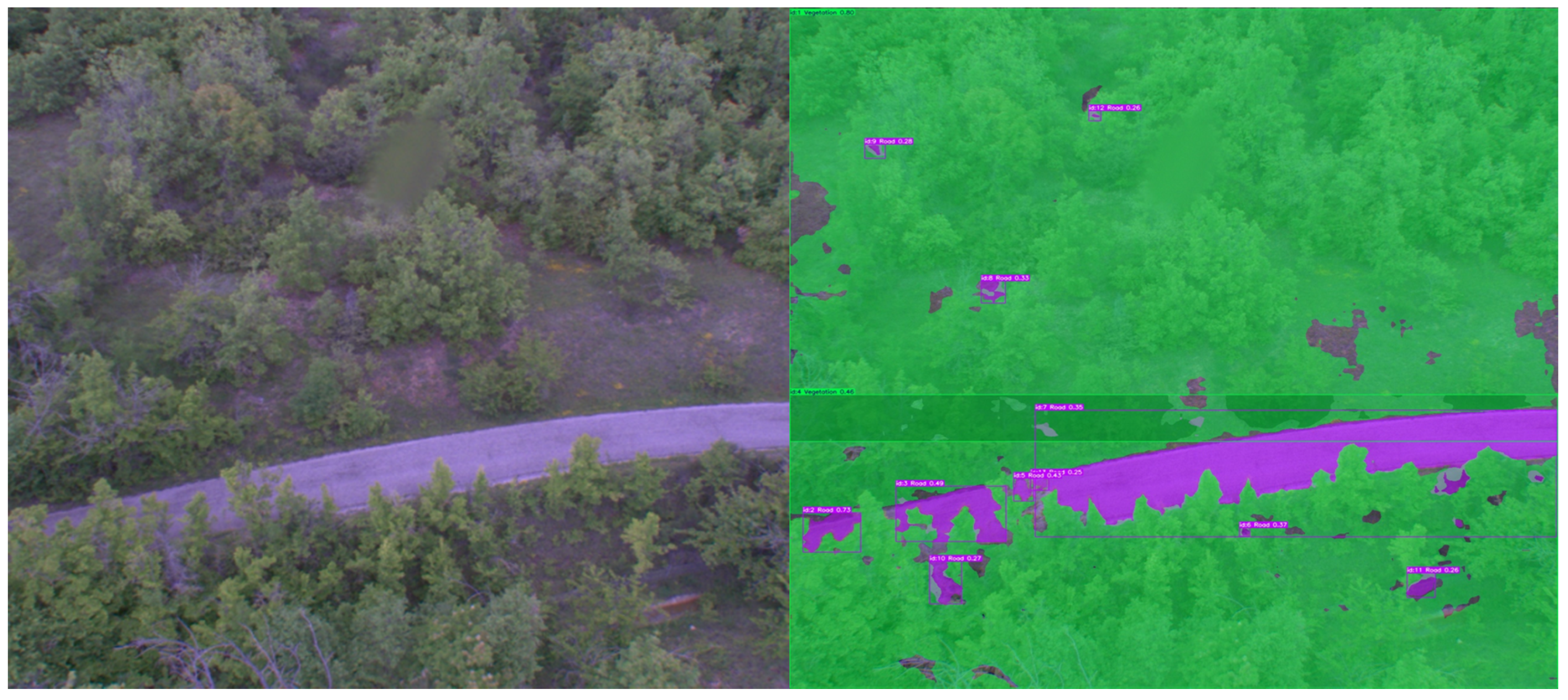
| Class | IoU (%) | Acc (%) |
|---|---|---|
| Background | 99.11 | 99.53 |
| Road | 96.61 | 98.04 |
| Vegetation | 76.51 | 87.63 |
| Indicator | REFERENCE (Conventional Process) | BEEYONDERS (Automated Inspection Process) | Indicative Impact |
|---|---|---|---|
| Safety Exposure | Medium–high (routine work near live lanes) | Very low (remote operations, no roadside presence) | Substantial reduction in worker exposure |
| Environmental Impact | Diesel/hybrid fleet → fuel consumption and CO2 emissions | Electric AMRs & UAVs → low-carbon operation | Potential reduction in operational emissions |
| Data Integration | Manual or semi-automatic upload; separate systems | Fully automatic cloud sync to digital twin | Improved real-time integration & traceability |
| Inspection Frequency | Annual + targeted repeats | Annual + on-demand or continuous digital checks | Increased temporal monitoring capability |
| Cost Drivers | Labour, fuel, vehicle maintenance | Equipment amortisation, energy, software | Shift from operational to capital cost; potential long-term savings |
| Operational Characteristics | High throughput but labour-intensive; moderate safety; fragmented data chain | Lower per-unit speed but scalable, safe, and digitally integrated | Operational procedure shifts from labour-intensive to technology-driven operations |
| Inspection Type | Horizontal Signage | Vertical Signage | Obstacle Detection | ||||
|---|---|---|---|---|---|---|---|
| Diesel | Hybrid/ Petrol | Diesel | Hybrid/ Petrol | Diesel | Hybrid/ Petrol | Electric | |
| Distance covered (vehicles·km) | 1 | 1 | 1 | 1 | 4 | 4 | 4 |
| Fuel consumption rate (L /100 km) | 8 | 5.6 | 8 | 5.6 | 8 | 5.6 | n/a |
| Total fuel per 1 km (L) | 0.08 | 0.056 | 0.08 | 0.056 | 0.32 | 0.224 | n/a |
| Energy consumption rate per km (kWh) | 0.80 | 0.54 | 0.80 | 0.54 | 3.20 | 2.17 | 0.80 |
| Total energy consumption per km (kWh): | |||||||
| Only diesel vehicles: 4.8 | |||||||
| Only hybrid/petrol vehicles: 3.26 | |||||||
| Diesel for vertical + horizontal, EV for obstacle detection: 2.4 | |||||||
| Hybrid/petrol for vertical + horizontal, EV for obstacle detection: 1.88 | |||||||
| Inspection Type | Horizontal Signage (1 AMR) | Vertical Signage (1 UAV) | Obstacle Detection (3 UAVs) | IT Equipment (Laptop) |
|---|---|---|---|---|
| Electricity consumption per km (kWh) | 0.12 | 0.11 | 0.33 | 0.03 |
| Total electricity consumption per km (kWh): 0.59 | ||||
| Impact Indicator | Only Diesel Vehicles | Only Hybrid/ Petrol | Diesel for Vertical + Horizontal, EV for Obstacle Detection | Hybrid/Petrol for Vertical + Horizontal, EV for Obstacle Detection | Unit |
|---|---|---|---|---|---|
| Global Warming Potential total (GWP-total) | 2.49 | 1.75 | 1.79 | 1.54 | kg CO2 eq./km |
| Global Warming Potential fossil fuels (GWP-fossil) | 2.49 | 1.75 | kg CO2 eq./km | ||
| Global Warming Potential biogenic (GWP-biogenic) | kg CO2 eq./km | ||||
| Global Warming Potential land use and land use change (GWP-luluc) | kg CO2 eq./km | ||||
| Abiotic depletion potential fossil resources (ADPF) | MJ/km | ||||
| Abiotic depletion potential non-fossil resources (ADPE) | kg Sb eq./km | ||||
| Acidification potential Accumulated Exceedance (AP) | mol H+ eq./km | ||||
| Depletion potential of the stratospheric ozone layer (ODP) | kg CFC-11 eq./km | ||||
| Eutrophication potential freshwater (EP-freshwater) | kg P eq./km | ||||
| Eutrophication potential marine (EP-marine) | kg N eq./km | ||||
| Eutrophication potential terrestrial (EP-terrestrial) | mol N eq./km | ||||
| Photochemical Ozone Creation Potential (POCP) | kg NMVOC eq./km | ||||
| Water (user) deprivation potential (WDP) | m3 World eq./km |
| Impact Indicator | Horizontal, Vertical and Obstacle Detection | Unit |
|---|---|---|
| Global Warming Potential total (GWP-total) | kg CO2 eq./km | |
| Global Warming Potential fossil fuels (GWP-fossil) | kg CO2 eq./km | |
| Global Warming Potential biogenic (GWP-biogenic) | kg CO2 eq./km | |
| Global Warming Potential land use and land use change (GWP-luluc) | kg CO2 eq./km | |
| Abiotic depletion potential fossil resources (ADPF) | 3.65 | MJ/km |
| Abiotic depletion potential non-fossil resources (ADPE) | kg Sb eq./km | |
| Acidification potential, Accumulated Exceedance (AP) | mol H+ eq./km | |
| Depletion potential of the stratospheric ozone layer (ODP) | kg CFC-11 eq./km | |
| Eutrophication potential freshwater (EP-freshwater) | kg P eq./km | |
| Eutrophication potential marine (EP-marine) | kg N eq./km | |
| Eutrophication potential terrestrial (EP-terrestrial) | mol N eq./km | |
| Photochemical Ozone Creation Potential (POCP) | kg NMVOC eq./km | |
| Water (user) deprivation potential (WDP) | m3 World eq./km |
Disclaimer/Publisher’s Note: The statements, opinions and data contained in all publications are solely those of the individual author(s) and contributor(s) and not of MDPI and/or the editor(s). MDPI and/or the editor(s) disclaim responsibility for any injury to people or property resulting from any ideas, methods, instructions or products referred to in the content. |
© 2026 by the authors. Licensee MDPI, Basel, Switzerland. This article is an open access article distributed under the terms and conditions of the Creative Commons Attribution (CC BY) license.
Share and Cite
Villaverde, I.; Sallé, D.; Montes-Grova, M.A.; Jiménez-Cámara, P.; Castelruiz-Aguirre, A.; Pastorelly, N.; Jimenez Fernandez, J.C.; Stipanovic, I.; Skaric, S.; Rodik, D. A Digital Twin-Driven System for Road Maintenance: Integrating UAVs and AMRs for Automated Inspection and Measurement. Infrastructures 2026, 11, 124. https://doi.org/10.3390/infrastructures11040124
Villaverde I, Sallé D, Montes-Grova MA, Jiménez-Cámara P, Castelruiz-Aguirre A, Pastorelly N, Jimenez Fernandez JC, Stipanovic I, Skaric S, Rodik D. A Digital Twin-Driven System for Road Maintenance: Integrating UAVs and AMRs for Automated Inspection and Measurement. Infrastructures. 2026; 11(4):124. https://doi.org/10.3390/infrastructures11040124
Chicago/Turabian StyleVillaverde, Ivan, Damien Sallé, Marco Antonio Montes-Grova, Pablo Jiménez-Cámara, Amaia Castelruiz-Aguirre, Nicolas Pastorelly, Jose Carlos Jimenez Fernandez, Irina Stipanovic, Sandra Skaric, and Daniel Rodik. 2026. "A Digital Twin-Driven System for Road Maintenance: Integrating UAVs and AMRs for Automated Inspection and Measurement" Infrastructures 11, no. 4: 124. https://doi.org/10.3390/infrastructures11040124
APA StyleVillaverde, I., Sallé, D., Montes-Grova, M. A., Jiménez-Cámara, P., Castelruiz-Aguirre, A., Pastorelly, N., Jimenez Fernandez, J. C., Stipanovic, I., Skaric, S., & Rodik, D. (2026). A Digital Twin-Driven System for Road Maintenance: Integrating UAVs and AMRs for Automated Inspection and Measurement. Infrastructures, 11(4), 124. https://doi.org/10.3390/infrastructures11040124