Technical Note

A Geospatial Approach to Improving Fish Species Detection in Maumee Bay, Lake Erie

1
Alpena Fish and Wildlife Conservation Office–Detroit River Substation, U.S. Fish and Wildlife Service, 28403 Old North Gibraltar Road, Gibraltar, MI 48173, USA
2
Lake St. Clair Fisheries Research Station, Michigan Department of Natural Resources, 33135 South River Road, Harrison Township, MI 48045, USA
3
Alpena Fish and Wildlife Conservation Office, U.S. Fish and Wildlife Service, 480 W. Fletcher Street, Alpena, MI 49707, USA
*
Author to whom correspondence should be addressed.
Submission received: 29 November 2022 / Revised: 12 December 2022 / Accepted: 19 December 2022 / Published: 21 December 2022
(This article belongs to the Special Issue Advances in Ecology and Management of Aquatic Invasive Species)

Abstract

:
Maumee Bay of western Lake Erie is at high risk for invasion by aquatic invasive species due to large urban and suburban populations, commercial shipping traffic, recreational boating, and aquaculture ponds. The U.S. Fish and Wildlife Service’s Early Detection and Monitoring (EDM) program has been monitoring for new invasive species since 2013 and is continually looking to adapt sampling methods to improve efficiency to increase the chance of detecting new aquatic invasive species at low abundances. From 2013–2016, the program used a random sampling design in Maumee Bay with three gear types: boat electrofishing, paired fyke nets, and bottom trawling. Capture data from the initial three years was used to spatially explore fish species richness with the hot spot analysis (Getis-Ord Gi*) in ArcGIS. In 2017, targeted sites in areas with high species richness (hot spots) were added to the randomly sampled sites to determine if the addition of targeted sampling would increase fish species detection rates and detection of rare species. Results suggest that this hybrid sampling design improved sampling efficiency as species not detected or were rare in previous survey years were captured and species were detected at a faster rate (i.e., in less sampling effort), particularly for shallow-water gear types. Through exploring past data and experimenting with targeted sampling, the EDM program will continue to refine and adapt sampling efforts to improve efficiency and provide valuable knowledge for the early detection of aquatic invasive species. The use of geospatial techniques such as hot spot analysis is one approach fisheries researchers and managers can use to incorporate targeted sampling in a non-subjective way to improve species detection.

1. Introduction

The detection of rare species is important for managing invasive and endangered species and enhances knowledge of species richness [1]. Detecting endangered species can help identify critical habitats that should be protected to enhance survival or reproductive success [2]. Detecting newly introduced nonnative species at low abundance and limited distribution is critical for possible eradication [3]. Because rare species are usually found in low abundance, detection in any environment presents challenges. In aquatic systems, detection probabilities for traditional sampling gears can be even lower because of low capture probabilities for individual fish [4]. Detecting rare species requires extensive surveillance, considerable time and effort, and oftentimes the effort required to achieve high detection probability is not possible on limited budgets [2,5].
Sampling designs created for the early detection of aquatic invasive species rarely are statistically based and may require exploring many habitat types and using several capture methods [5,6]. In the Laurentian Great Lakes (Great Lakes for the remainder of paper), over 180 species have been introduced through several vectors and the threat of new invaders such as Bighead Carp Hypophthalmichthys nobilis and Silver Carp H. molitrix remain high [7,8]. Trebitz et al. [9], and Hoffman et al. [5] examined invasive species early detection strategies, and the U. S. Fish and Wildlife Service (USFWS) adopted those efforts into a strategic framework [10] to implement an Aquatic Invasive Species Early Detection and Monitoring (AIS EDM) program in the Great Lakes with the goal of detecting newly introduced aquatic invasive species at low abundances [11].
Locations across Lake Erie and the entire Great Lakes have been evaluated for their risk of invasion by new invasive species [12,13]. Maumee Bay was identified as the highest risk location in Lake Erie due to high human population, commercial shipping traffic, recreational boating, and aquaculture activity [12]. Aquatic invasive species early detection sampling was initiated in Maumee Bay in 2013 when the USFWS implemented a comprehensive Great Lakes EDM program to improve the early detection of aquatic invasive species by attempting to detect the entire fish community – including rare or unique species [9]. Species accumulation theory [14] was used as a metric to evaluate the effort of the EDM program, with the goal to detect 95% of all known and available fish species to obtain high probability of early detection [5].
The USFWS was able to achieve an estimated 94% detection rate (as determined by species accumulation analysis) after four years of random sampling in Maumee Bay [15]. Even so, efforts to move toward targeted sampling would increase the likelihood of detecting a new species and may increase the rate and likelihood that a 95% detection rate could be achieved. Following an adaptive management process (implement, evaluate, refine), the sampling strategy was evaluated to identify areas where gear sampling efficiencies and species detection rates could be improved. The adaptive approach spatially examined past sampling data to identify and target species-rich areas. Geospatial techniques such as the hot spot analysis (Getis-Ord Gi*) may be used to identify spatial clusters with similar values [16]. Areas with high species richness may harbor beneficial habitats for many species, including those that are rare or newly introduced, and thus may be beneficial areas to implement targeted sampling [5,17].
To explore the use of targeted sites to increase sampling efficiency, a hot spot analysis was conducted using fish sampling data collected by the USFWS’s EDM program from 2013–2016 for three gear types to examine fish species richness patterns in Maumee Bay. In 2017, species-rich areas were targeted in addition to randomly selected sites (e.g., a hybrid approach) as a part of the EDM program. The objective of this study was to determine if the incorporation of targeted sampling in species-rich areas would (1) increase the number of rare species detected and (2) improve species detection efficiency for each gear type.

2. Methods

2.1. Study Area

Maumee Bay is in the southwest corner of Lake Erie’s western basin near Toledo, Ohio, USA, and covers both Michigan and Ohio waters of Lake Erie (Figure 1). Toledo is the fourth largest city by population size in Ohio and is a major commercial shipping port. Maumee Bay supports tourism, including recreational boating and fishing. The Maumee River, the largest tributary to Lake Erie, was named an Area of Concern as part of the Great Lakes Water Quality Agreement of 1987 due to sediment contamination and agricultural runoff. The study area starts in the Maumee River approximately 1 km upstream from the river mouth in Maumee Bay and extends into Maumee Bay northeast approximately 26 km to a parallel boundary extending north from the outer boundary of Cedar Point National Wildlife Refuge northwest to Grand View, Michigan. The total surface area of the survey location is approximately 9200 ha (Figure 1).

2.2. Fish Sampling

From 2013–2016 a target of 15 “traditional” sampling sites per year for each gear type, electrofishing, paired fyke nets, and bottom trawling, were sampled using randomly generated locations determined with ArcGIS 10.1/10.2 in Maumee Bay. Gear types and site selection procedures were based on recommendations from Trebitz et al. [9], USFWS [18], and Hayer [19]. Five “hot spot” sites were added to the 15 traditional sites (20 sites total) for each gear type in 2017 to evaluate the addition of targeted sampling locations (Figure 1). The methods to determine the hot spot sites are detailed in Section 2.3. When a site was unable to be sampled (e.g., wrong depth, inaccessible), the site could be moved up to 1 km to a more suitable location, or a new site was selected from a list of previously allocated randomized alternate locations.
Electrofishing was conducted from a boat at night (between one hour after sunset and one hour before sunrise), in water depths of 1–3 m. Electrofishing occurred along the shoreline, for a total electrofishing time of 10 min per sampling site. Multiple electrofishing boats were used over the course of the study with two boats using a Smith-Root (5.0 and 7.5 GPP [generator powered pulsator]) electrofishing system, and one boat using a Midwest Lake Electrofishing System (MLES; Infinity 40 amp) with a 60-Hz pulsed DC and 40% duty cycle. Electrofishing was not conducted in 2013 and 2015 due to logistical constraints.
Paired fyke nets with 4.7 mm stretch-mesh netting were created by attaching two 0.9 m × 1.2 m fyke nets to a 15.0 m × 0.9 m lead. Individual nets consisted of two rectangular frames 0.9 m × 1.2 m, followed by four circular rings 0.9 m in diameter. Paired fyke nets were set parallel to the shoreline in water depths of 1–2 m. Nets were set during the day and remained in the water overnight for a period of 12–24 hours.
Bottom trawling was conducted using a Marinovich design otter trawl with a 4.9 m head rope, 3.8 cm stretch mesh body, and a 3.1 mm stretch mesh cod end. Trawl tows were performed at depths greater than 2 m along contours at a speed of approximately 4 km/h for 5 min.
Sampling occurred from 27 August–18 September 2013; 25 August–27 October 2014; 31 August–15 September 2015; 29 August–5 October 2016; and 14 August–27 September 2017. All fish were identified to species. If a fish could not be identified in the field, the specimen was preserved in 95% ethanol or frozen and morphologically identified in the laboratory. When morphological identification was not possible, a fin clip was preserved in 95% ethanol for genetic identification at the USFWS Whitney Genetics Lab.

2.3. Geospatial Analysis

The spatial distribution of fish species richness by gear type was analyzed using spatial statistics in ArcGIS 10.5. All distance methods were set to Euclidean distance (i.e., straight line distance). Moran’s I, a spatial autocorrelation analysis, was used to evaluate the presence of spatial clustering between the sampling locations [20,21]. The zone of indifference was the spatial relationship used for Moran’s I and the hot spot analysis (Getis-Ord Gi*). The zone of indifference treats features within a specified area as neighbors, features outside the area are also neighbors but they are assigned a smaller and smaller weight as distance increases. The Moran’s I distance band threshold (i.e., search radius) setting was the ArcGIS default value ensuring every feature had at least one neighbor. The hot spot analysis distance band threshold was determined using the first significant peak from the incremental spatial autocorrelation analysis, which represents a distance where spatial clustering was pronounced [20].
The number of fish species caught at a sampling location by gear type from 2013–2016 were input into the hot spot analysis to determine high or low spatial clustering. The output from the hot spot analysis provides z-scores and p values that identify significance of clustering at a given distance [16]. Z-scores greater than 1.96 or below −1.96 indicate statistically significant hot or cold spots with p values ≤ 0.05. The z-scores from the hot spot analysis were interpolated using the inverse distance weighed (IDW) tool to generate gradient layers of potential fish species richness to better visualize patterns and identify areas for targeted sampling in Maumee Bay (Figure 1).

2.4. Species Accumulation Curve

To determine if the addition of targeted sampling in hot spot areas in 2017 increased species richness with equal sampling effort, species accumulation curves were constructed using the iNEXT package [22] in RStudio (version 1.0.1530) [23], along with sampling efficiency percentages. Sample size-based interpolation and extrapolation of species diversity data were performed using incidence-frequency data. Ten of the traditional sites were randomly chosen using the sample function with no replacement in RStudio for all three gear types, separately. Five hot spot sites were then substituted for the five traditional sites that were removed to equal 15 sites total for 2017, allowing for the comparison of the traditional and hybrid sampling approaches. Species richness estimates were determined by 50 bootstrap iterations performed at 40 knots to generate 95% confidence intervals. Sampling efficiency is described as the observed species richness divided by the estimated species richness and reported as a percentage. These results were then compared to running the same analysis using the 15 traditional sites. The catch was also examined for the presence of rare species to learn whether hot spot areas held more rare species relative to randomly selected sites. Unique and duplicate species (i.e., species that only occur in one and two samples, respectively; [24]) from 2013–2016 that were caught in 2017 were noted and used as proxies for rare species.

3. Results

3.1. Hot Spot Determination

Areas with high species richness were determined for all three gear types using 2013–2016 sampling data and the significance of species richness clustering varied among gear types (Table 1). Data for electrofishing (n = 24) was below the recommended minimum number of samples (n = 30) and should be interpreted with caution. Additionally, bottom trawl data from 2014 was not included because sampling took place much later in the year and may have influenced the number of fish captured. The number of species captured by any gear type ranged from 0 to 25 with a mean number of species by gear type ranging from 4.2 to 10.2 (Table 1). Paired fyke nets generally captured more species relative to the other gear types (Table 1). The Moran’s I statistic indicated clustering among species richness locations for paired fyke nets (p = 0.02) and bottom trawls (p < 0.01), but not significantly for electrofishing (p = 0.08). The search distance radius (first peak) used for the hot spot analysis varied among gear types and decreased in length when the number of samples increased (Table 1).
With a limited number of exploratory samples for electrofishing, a small targeted hot spot zone was determined near the one significant (p ≤ 0.05) identified hot spot in the western portion of Maumee Bay (Figure 1) so that targeted sampling could still occur using this gear type despite nonsignificant clustering. Paired fyke nets had five significant hot spots and two significant cold spots (i.e., low species richness). The sites with high species richness were located nearshore in the western portion of the bay, while the cold spots were clustered offshore (Figure 1). Bottom trawls had six significant hot spots and 21 significant cold spots. Sites with high species richness were clustered in the southeastern portion of the bay, while the cold spots were clustered in the northern portion of the bay (Figure 1). The targeted hot spot zones for 2017 sampling were in similar locations for electrofishing and paired fyke nets in the western portion of the bay, and offshore near the mouth of the shipping channel for bottom trawls (Figure 1).

3.2. Random vs. Hybrid Sampling

In 2017, five species were detected at hot spot sites (combining all gear types) that were not detected at traditional sites despite the comparatively low effort at hot spot sites (three times more effort at traditional sites): Bowfin Amia calva, Golden Shiner Notemigonus crysoleucas, Northern Pike Esox lucius, Shorthead Redhorse Moxostoma macrolepidotum, and Smallmouth Bass Micropterus dolomieu (Table 2). Traditional sampling sites captured seven species that were not detected at hot spot sites: Black Crappie Pomoxis nigromaculatus, Common Carp Cyprinus carpio, Common Shiner Luxilus cornutus, Longnose Gar Lepisosteus osseus, Rock Bass Ambloplites rupestris, Tadpole Madtom Noturus gyrinus, and White Sucker Catostomus commersonii. Fourteen species were caught at the five electrofishing hot spot sites that were not caught at the 15 traditional electrofishing sites, while one species was caught at the traditional sites that was not caught at the hot spot sites (Table 2). Nine total species were caught at the 15 traditional electrofishing sites while 22 were caught at the five hot spot sites. Five species were caught at the five fyke net hot spot sites that were not caught at the 15 traditional sites, while five species were caught at the traditional sites that were not caught at the hot spot sites (Table 2).
Twenty-two total species were caught at the 15 traditional fyke net sites and 22 were caught at the five hot spot sites. One species was caught at one of the five bottom trawling hot spot sites that was not caught at the 15 traditional sites, while six species were caught at the traditional sites that were not caught at the hot spot sites (Table 2). Eighteen total species were caught at the 15 traditional bottom trawling sites while 13 were caught at the five hot spot sites. A total of 12 unique or duplicate species (based on 2013–2016 data) were collected in 2017 (Table 2). Six of these species were collected at hot spot sites and seven were collected at traditional sites. No previously undocumented nonnative species were collected during the study period.

3.3. Species Accumulation

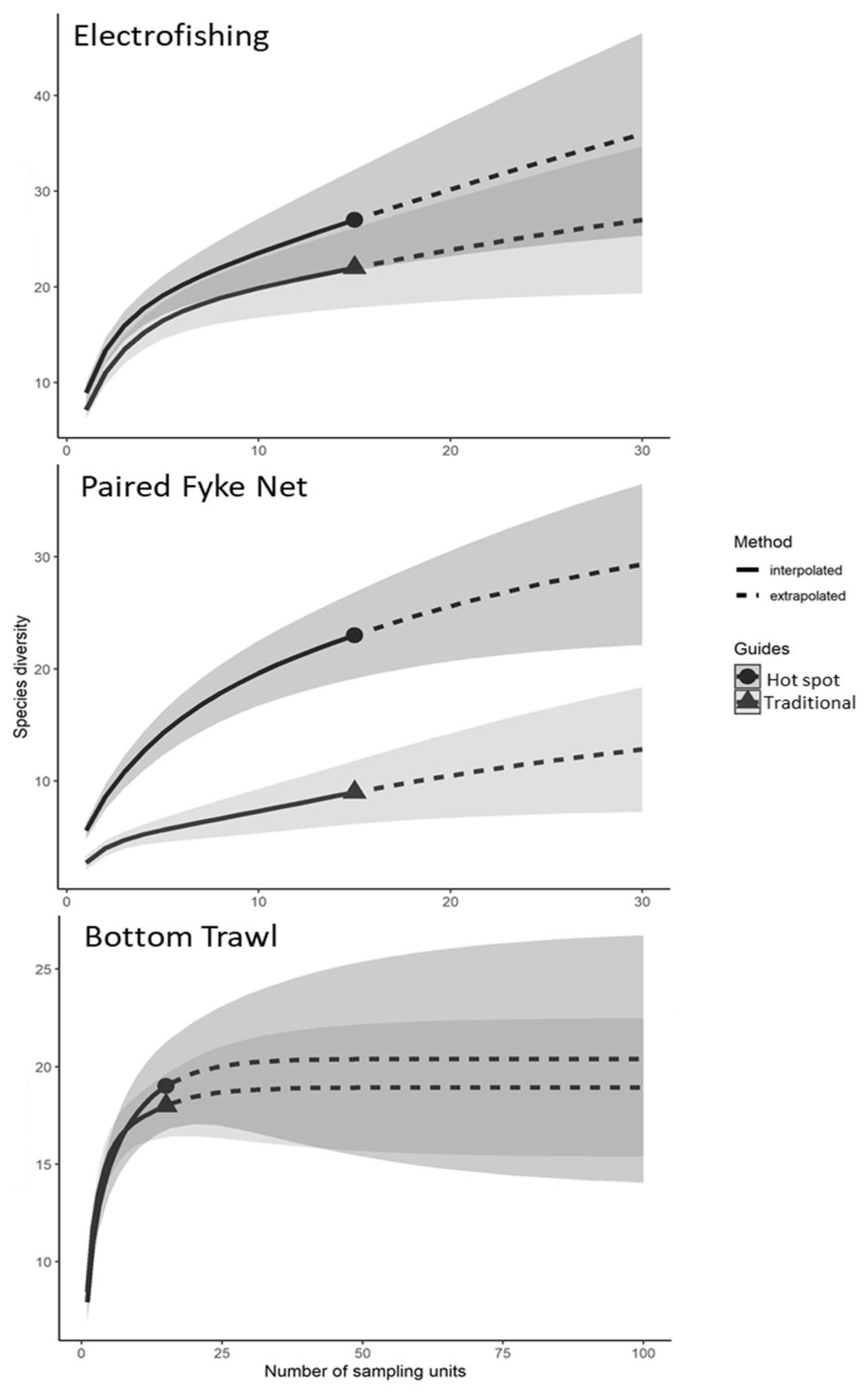
Species accumulation curve analysis showed improvements in performance for 2017 electrofishing and paired fyke net sampling after including targeted sites in hot spot areas (i.e., the hybrid sampling approach) versus traditional random site locations (Figure 2). The steepness of the initial rise in the curves indicated that species were accumulated faster (i.e., more efficiently) when including targeted sampling in hot spot areas for electrofishing and paired fyke nets but not for bottom trawling (Figure 2). Estimates of asymptotic species richness for traditional random sampling in 2017 were 18.3 (95% CI: 10.8–57.7) for electrofishing, 38.8 (95% CI: 24.4–141.6) for fyke nets, and 18.9 (95% CI: 18.1–31.4) for bottom trawling. Estimates of asymptotic species richness for traditional sites combined with targeted sampling at hot spot sites were 32.0 (95% CI: 24.0–70.9) for electrofishing, 39.9 (95% CI: 27.8–104.3) for fyke nets, and 19.4 (95% CI: 18.1–30.2) for bottom trawling. Overall, asymptotic species richness increased with the addition of hot spot sites, although the large 95% confidence intervals did overlap (not surprising due to high variability in catch among sites).
Sampling efficiency based on observed versus asymptotic species richness of traditional random sampling in 2017 was 49% for electrofishing, and 56% for paired fyke nets, and 95% for bottom trawling. Sampling efficiency of ten traditional sites with five hot spot sites were 69% for electrofishing, 62% for paired fyke nets, and 93% for bottom trawling. It was also estimated based on 2017 data that reaching 95% sampling efficiency with traditional random sampling would require approximately 85 samples for electrofishing and 105 samples for paired fyke nets while using the hybrid sampling approach would require 55 samples for electrofishing and 70 samples for paired fyke nets.

4. Discussion

Incorporation of a hot spot analysis and subsequent hybrid sampling was beneficial to the EDM program in Maumee Bay in 2017 but success varied by gear. The resulting hot spots were a better predictor of species-rich areas for the shallow water gears, electrofishing and paired fyke nets, compared to bottom trawling. Random site selection by depth strata for shallow waters may often select sites away from the shore in sand or mudflat areas that lack structure and are ecological deserts, leading to lower catch and species diversity. Many species use nearshore habitat as cover for protection from predators, for feeding, or traverse along shorelines as they move to new locations [25]. Past samples that collected diverse catches identified by the hot spot analysis may have been associated with vegetative cover or other areas where fish can take refuge (e.g., woody debris). Unfortunately, the EDM program did not consistently record substrate, vegetation, or woody debris during these survey years, so we are unable to validate this hypothesis. However, the use of this analysis to identify species-rich areas may be a proxy for locating preferred fish habitats. Bottom trawl sampling efficiency likely was not improved by incorporating this analysis because trawl locations were in waters greater than 2 m, where heavy vegetation is less likely due to the turbidity of the area and could not be conducted over structured areas such as rocks and woody debris due to risk of net hang ups. Additionally, many of the 2017 traditional bottom trawl sites were coincidentally located in hot spot areas (7 out of 15) and may have contributed to the similar species accumulation and sampling efficiency of traditional sampling compared to hybrid sampling.
Including targeted sampling effort in shallow water locations designated as “hot spots” improved species accumulation (detected species at a faster rate) and sampling efficiency (detected a higher proportion of estimated total species present) for boat electrofishing and paired fyke nets. The difference in the number of sites required to reach 95% species detection was estimated to be considerably lower when including targeted sampling for electrofishing and paired fyke netting as well. However, species accumulation and sampling efficiency were not improved at deeper sites using bottom trawling. Despite three times as much effort being allocated to traditional sites, several species were collected at hot spot sites in 2017 that were not collected at the traditional random sites. Additionally, there were numerous rare species (i.e., unique and duplicate species) collected from 2013 to 2016 using random sampling that were collected at hot spot sites in 2017. Incorporating targeted sampling during bottom trawling did not improve species detection.
Incorporating targeted sampling into survey designs yields improved efficiencies in both species detection and detection of rare species. This is especially true in instances where resources (i.e., personnel and funding) are limited, and habitat assessments cannot be conducted to inform a targeted or stratified sampling design by habitat type. Targeted sampling can improve species detection [5,9] but determining areas to target may not be possible without prior knowledge of or adequate resources to determine habitats present. Using a random sampling design for several years to inform a hot spot analysis is an example of using an adaptive evaluation approach to sampling design, which has been shown to improve species detection [6,26]. Additionally, using the hot spot analysis allows for statistical justification of targeted sampling sites rather than subjective choices that may be inconsistent among sampling crews or individuals.
Although targeting hot spot sites was beneficial for species detection, and thus increasing the likelihood of detecting any newly introduced aquatic invasive species, including random sites or sites outside of the targeted areas is still beneficial. Only utilizing targeted sampling could result in “false negatives” as some habitats may contain fewer, but unique species [9,26]. Additionally, in the case of early detection monitoring for aquatic invasive species, it is often difficult to predict what habitat new species will prefer [27]. It is possible they may prefer or have improved chances of establishment in habitats that have lower species richness [28].
Although successful, one downside to the hot spot analysis was that it required ample spatial coverage and sample size (minimum of 30 sites) to successfully determine hot spots. For the EDM program, that meant numerous years of effort since only 15 samples per gear type per year were targeted in Maumee Bay during the study period. Although electrofishing only had 24 of the minimum 30 sites for determining hot spots in our study, the resulting hot spot area was in a similar location as the paired fyke net (another shallow water gear) hot spot area and suggests it was an actual high species richness area. If other monitoring programs can dedicate effort to a single or fewer locations, they could likely get adequate coverage in much less time. This study only examined the success of applying the hot spot analysis for one season due to changes in the sampling strategy of the EDM program in subsequent years, but results suggest using a hot spot analysis to select and incorporate non-subjective targeted sampling sites can result in improved species detection and sampling efficiency.

5. Conclusions

Incorporation of the hot spot analysis as a tool to select targeted sampling sites improved species detection for boat electrofishing and paired fyke nets. While improving detection rates and detection of rare species, it also allowed for the statistical justification of targeted sites and served as an adaptive approach after several years of using a random sampling design. Although the data suggests using a sampling design that includes targeted sites with high biodiversity improves species detection and detection of rare species (thus increasing the likelihood of detecting newly introduced aquatic invasive species), we recommend maintaining some level of random sampling outside of targeted areas to provide greater spatial coverage and to aid with the detection of new aquatic invasive species that may prefer or more easily invade habitats that are not species-rich.

Author Contributions

Conceptualization, A.S.B., P.T. and A.B.; methodology, A.S.B., P.T. and A.B.; formal analysis, J.B., P.T. and M.M.; investigation, J.B., A.S.B., P.T., M.M. and A.B.; data curation, J.B., A.S.B., P.T., M.M. and A.B.; writing—original draft preparation, J.B.; writing—review and editing, J.B., A.S.B., P.T., M.M. and A.B. All authors have read and agreed to the published version of the manuscript.

Funding

This project was funded in part by the Great Lakes Restoration Initiative.

Institutional Review Board Statement

All fishes were collected and handled following the rules of fish collection permits issued by the Michigan Department of Natural Resources and Ohio Department of Natural Resources. Ethical approval from an Institutional Review Board was not required as fishes were released back into the water after identifying to species.

Data Availability Statement

Data are available upon request.

Acknowledgments

We would like to thank our partners and staff who assisted with the planning, sampling, and analysis associated with this effort. We also thank Kristen Towne for providing a review of this manuscript. We also thank the journal reviewers for providing comments for the paper’s improvement. The findings and conclusions in this document are those of the authors and do not necessarily represent the views of the U.S. Fish and Wildlife Service.

Conflicts of Interest

The authors declare no conflict of interest.

References

  1. Cao, Y.; Williams, D.D.; Williams, N.E. How important are rare species in aquatic community ecology and bioassessment? Limnol. Oceanogr. 1998, 43, 1403–1409. [Google Scholar] [CrossRef]
  2. Jerde, C.L.; Mahon, A.R.; Chadderton, W.L.; Lodge, D.M. “Sight-unseen” detection of rare aquatic species using environmental DNA. Conserv. Lett. 2011, 4, 150–157. [Google Scholar] [CrossRef]
  3. Harvey, R.G.; Mazzotti, F.J. The Invasion Curve: A Tool for Understanding Invasive Species Management in South Florida. IFAS Publication Number; WEC347. University of Florida: Gainesville, FL, USA, 2014. Available online: https://edis.ifas.ufl.edu/publication/UW392 (accessed on 18 December 2022).
  4. Magnuson, J.J.; Benson, B.J.; McLain, A.S. Insights on species richness and turnover from long-term ecological research: Fishes in north temperate lakes. Am. Zool. 1994, 34, 437–451. [Google Scholar] [CrossRef] [Green Version]
  5. Hoffman, J.C.; Kelly, J.R.; Trebitz, A.S.; Peterson, G.S.; West, C.W. Effort and potential efficiencies for aquatic non-native species early detection. Can. J. Fish. Aquat. Sci. 2011, 68, 2064–2079. [Google Scholar] [CrossRef]
  6. Trebitz, A.S.; Hoffman, J.C.; Darling, J.A.; Pilgrim, E.M.; Kelly, J.R.; Brown, E.A.; Chadderton, W.L.; Egan, S.P.; Grey, E.K.; Hashsham, S.A.; et al. Early detection monitoring for aquatic non-indigenous species: Optimizing surveillance, incorporating, advanced technologies, and identifying, research needs. J. Environ. Manage. 2017, 202, 299–310. [Google Scholar] [CrossRef]
  7. MICRA (Mississippi Interstate Cooperative Resource Association). Asian carp threat to the Great Lakes. River Crossings Newsl. Miss. Interstate Coop. Resour. Assoc. 2002, 11, 1–2. [Google Scholar]
  8. Ricciardi, A. Patterns of invasion in the Laurentian Great Lakes in relation to changes in vector activity. Divers. Distrib. 2006, 12, 425–433. [Google Scholar] [CrossRef]
  9. Trebitz, A.S.; Kelly, J.R.; Hoffman, J.C.; Peterson, G.S.; West, C.W. Exploiting habitat and gear patterns for efficient detection of rare and non-native benthos and fish in Great Lakes coastal ecosystems. Aquat. Invasions 2009, 4, 651–667. [Google Scholar] [CrossRef]
  10. USFWS. Strategic framework for the early detection in monitoring of non-native fishes and select benthic macroinvertebrates in the Great Lakes. In Great Lakes Comprehensive Aquatic Invasive Species Early Detection Monitoring Plan; U. S. Fish and Wildlife Service: Bloomington, MN, USA, 2014. [Google Scholar]
  11. Harris, B.S.; Smith, B.J.; Hayer, C.A. Development and implementation of an adaptive management approach for monitoring non-indigenous fishes in lower Green Bay, Lake Michigan. J. Great Lakes Res. 2018, 44, 960–969. [Google Scholar] [CrossRef]
  12. Tucker, A.J.; Chadderton, W.L.; Annis, G.; Davidson, A.D.; Hoffman, J.; Bossenbroek, J.; Hensler, S.; Hoff, M.; Jensen, E.; Kashian, D.; et al. A framework for aquatic species surveillance site selection and prioritization in the US waters of the Laurentian Great Lakes. Manag. Biol. Invasions 2020, 11, 607–632. [Google Scholar] [CrossRef]
  13. USFWS. Lake Erie Implementation Plan for the Early Detection of Non-Native Fishes and Select Benthic Macroinvertebrates; U. S. Fish and Wildlife Service, Alpena Fish and Wildlife Conservation Office, Alpena, Michigan and Lower Great Lakes Fish and Wildlife Conservation Office: Basom, NY, USA, 2016.
  14. Soberon, J.; Llorente, J. The use of species accumulation functions for the prediction of species richness. Conserv. Biol. 1993, 3, 480–488. [Google Scholar] [CrossRef]
  15. USFWS. Early Detection and Monitoring of Non-Native Fishes and Benthic Macroinvertebrates in Lake Erie, 2016; U. S. Fish and Wildlife Service, Alpena Fish and Wildlife Conservation Office, Alpena, Michigan and U. S. Fish and Wildlife Service, Lower Great Lakes Fish and Wildlife Conservation Office: Basom, NY, USA, 2017.
  16. Ord, J.K.; Getis, A. Local Spatial Autocorrelation Statistics: Distributional Issues and an Application. Geogr. Anal. 1995, 27, 286–306. [Google Scholar] [CrossRef]
  17. Stohlgren, T.J.; Binkley, D.; Chong, G.W.; Kalkhan, M.A.; Schell, L.D.; Bull, K.A.; Otsuki, Y.; Newman, G.; Bashkin, M.; Son, Y. Exotic plant species invade hot spots of native plant diversity. Ecol. Monogr. 1999, 69, 25–46. [Google Scholar] [CrossRef]
  18. USFWS. Recommended Sampling Gear Types and Standard Operating Procedures for the Early Detection of Non-Native Fishes and Select Benthic Macroinvertebrates in the Great Lakes; U. S. Fish and Wildlife Service: Bloomington, MN, USA, 2014.
  19. Hayer, C.-A. Recommended Sampling Gear Types and Standard Operating Procedures for the Early Detection of Non-native Fishes and Select Benthic Macroinvertebrates in the Great Lakes. U.S. Fish and Wildlife Service, Green Bay Fish and Wildlife Conservation Office Report Number: 2017-014; Green Bay Fish and Wildlife Conservation Office: New Franken, WI, USA, 2018.
  20. Jalali, M.A.; Ierodiaconou, D.; Gorfine, H.; Monk, J.; Rattray, A. Exploring spatiotemporal trends in commercial fishing effort of an Abalone fishing zone: A GIS-based hotspot model. PLoS ONE 2015, 10, e0122995. [Google Scholar] [CrossRef] [PubMed] [Green Version]
  21. Sanchez-Cuervo, A.M.; Aide, T.M. Identifying hotspots of deforestation and reforestation in Colombia (2001-2010): Implications for protected areas. Ecosphere 2013, 4, 1–21. [Google Scholar] [CrossRef]
  22. Hsieh, T.C.; Ma, K.H.; Chao, A. iNext: An R package for rarefaction and extrapolation of species diversity (Hill numbers). Methods Ecol. Evol. 2016, 7, 1451–1456. [Google Scholar] [CrossRef]
  23. RStudio Team. RStudio: Integrated Development for R. RStudio. PBC: Boston, MA, USA, 2020. Available online: http://www.rstudio.com(accessed on 18 December 2022).
  24. Chao, A.; Colwell, R.K.; Lin, C.-W.; Gotelli, N.J. Sufficient sampling for asymptotic minimum species richness estimators. Ecology 2009, 90, 1125–1133. [Google Scholar] [CrossRef]
  25. Francis, J.T.; Chiotti, J.A.; Boase, J.C.; Thomas, M.V.; Manny, B.A.; Roseman, E.F. A description of the nearshore fish communities in the Huron-Erie Corridor using multiple gear types. J. Great Lakes Res. 2014, 40, 52–61. [Google Scholar] [CrossRef]
  26. Hoffman, J.C.; Schloesser, J.; Trebitz, A.S.; Peterson, G.S.; Gutsch, M.; Quinlan, H.; Kelly, J.R. Sampling design for early detection of aquatic invasive species in Great Lakes ports. Fisheries 2016, 41, 27–37. [Google Scholar] [CrossRef]
  27. Hickley, P.; Chare, S. Fisheries for non-native species in England and Wales: Angling or the environment? Fish. Manage. Ecol. 2004, 11, 203–212. [Google Scholar] [CrossRef]
  28. Paavola, M.; Olenin, S.; Leppakoski, E. Are invasive species most successful in habitats of low native species richness across European brackish water seas? Estuar. Coast. Shelf. Sci. 2005, 64, 738–750. [Google Scholar] [CrossRef]
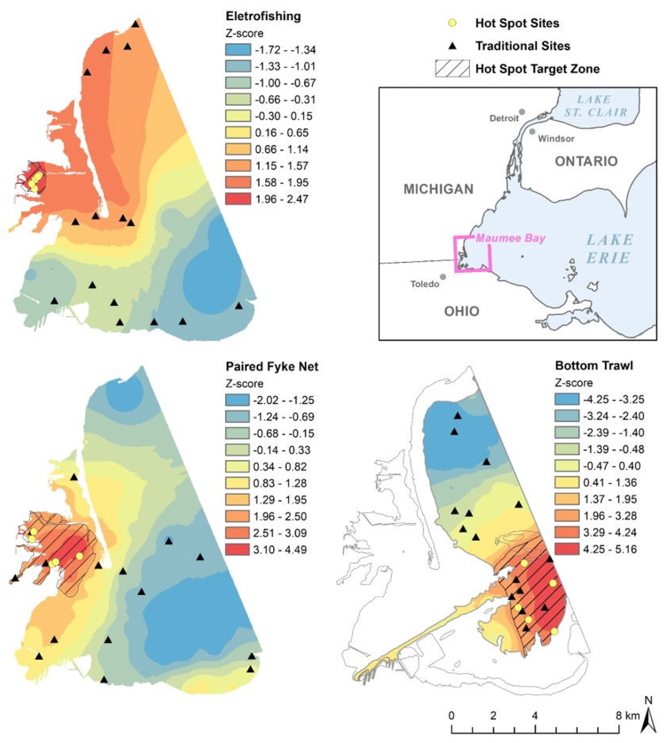
Figure 1. Maumee Bay showing 2017 sampling sites (both traditional and hot spot) by gear type and gradients of interpolated fish species richness z-scores from the hot spot analysis using randomly sampled data from 20132016 (see Section 2.3). Warm colors indicate higher species richness and cool colors indicate areas with lower species richness. The bottom trawl interpolated surface in the bottom right is within the 2 m or greater depth contour. The hot spot target zone, black diagonal lines, contains z-scores ≥ 1.96.
Fishes 08 00003 g001
Figure 2. Species accumulation curves for sampling gears at Maumee Bay in 2017. The triangle symbol indicates the species accumulation curve for traditional sampling sites (n = 15), while the circle symbol indicates the species accumulation curve for combined hot spot (n = 5) and selected traditional (n = 10) sampling sites. The solid lines represent the interpolated data while the dashed lines represent the extrapolated data. The shaded areas show 95% confidence intervals for each line.
Fishes 08 00003 g002
Table 1. Summary of Maumee Bay sampling results from 2013–2016.
ElectrofishingPaired Fyke NetBottom Trawl
Years2014, 20162013–20162013, 2015, 2016
# Sites246045
Range of Species0–174–253–11
Mean of Species (SD)4.2 (4.2)10.2 (4.0)7.4 (1.7)
Moran’s I p = 0.08p = 0.02p < 0.01
First Peak (m)3490.551627.782547.81
Table 2. Fish species captured (indicated by an “X”) in Maumee Bay during 2017 by gear type and site type (traditional n = 15, hot spot n = 5).
ElectrofishingPaired Fyke NetBottom Trawl
Fish SpeciesScientific NameTraditionalHot spot TraditionalHot spot TraditionalHot spot
Black Crappie *Pomoxis nigromaculatus X
BluegillLepomis macrochirus XXX
Bluntnose MinnowPimephales notatus XXX
Bowfin **Amia calva X
Brook SilversideLabidesthes sicculusXX
Brown BullheadAmeiurus nebulosusXXXX
Channel CatfishIctalurus punctatus XXX
Common Carp *Cyprinus carpio carpio X
Common ShinerLuxilus cornutus X
Emerald ShinerNotropis atherinoidesXXXXX
Freshwater DrumAplodinotus grunniens XXXXX
Gizzard ShadDorosoma cepedianumXXXXXX
Golden Shiner **Notemigonus crysoleucas X X
GoldfishCarassius auratus auratusXX X
Johnny DarterEtheostoma nigrum XX
Largemouth BassMicropterus salmoides XXX
LogperchPercina caprodes XXXXX
Longnose Gar *Lepisosteus osseusX
Mimic ShinerNotropis volucellusXXXXXX
Northern Pike **Esox lucius X X
PumpkinseedLepomis gibbosus XXXX
Rock Bass *Ambloplites rupestris X
Round GobyNeogobius melanostomus XXXX
Sand ShinerNotropis stramineus XXX
Shorthead Redhorse **Moxostoma macrolepidotum X X
Silver Chub **Macrhybopsis storeriana X XX
Smallmouth Bass *Micropterus dolomieu X
Spottail ShinerNotropis hudsonius XXXX
Tadpole Madtom *Noturus gyrinus X
Trout-PerchPercopsis omiscomaycus XX
WalleyeSander vitreusXX XXX
White BassMorone chrysops XXXXX
White PerchMorone americana XXXXX
White Sucker *Catostomus commersonii X
Yellow PerchPerca flavescensXXXXXX
* Unique species, a species collected at one location; ** Duplicate species, a species collected at two locations.
Disclaimer/Publisher’s Note: The statements, opinions and data contained in all publications are solely those of the individual author(s) and contributor(s) and not of MDPI and/or the editor(s). MDPI and/or the editor(s) disclaim responsibility for any injury to people or property resulting from any ideas, methods, instructions or products referred to in the content.